

Page 1
Rikaline
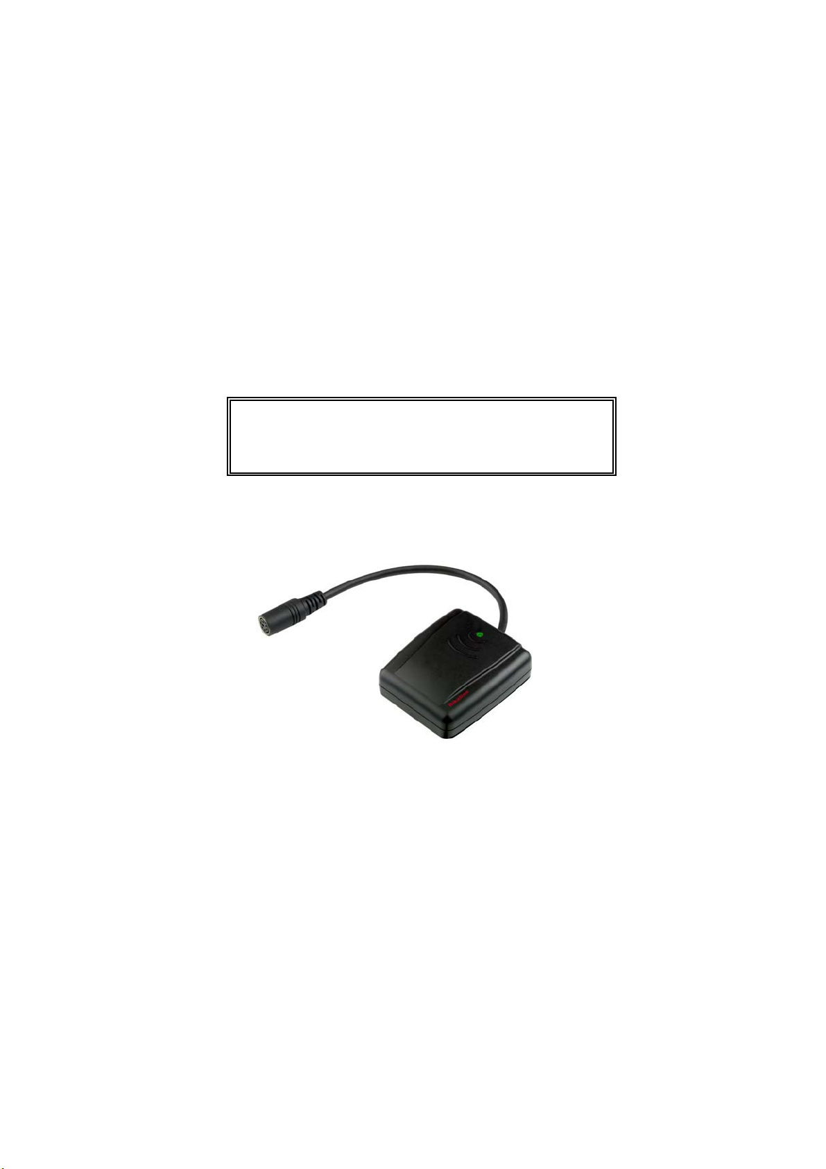
GPS-6011
GPS Receiver
User’s Guide
Oct. 06, 2002
High Accuracy --Low Power --------
Attractive Price --
Rikaline
5F-1, 125, Roosevelt Rd., Sec. 5, Taipei 116, Taiwan, R.O.C.
Phone: +886-2-2934-5456 Fax: +886-2-2934-4373
E-Mail: info@rikaline.com.tw Web: www.rikaline.com.tw
All Right Reserved
3 Meters (50%) or Meters (90%)
26mA at 3.3V in Continuous Mode and
With Active Antenna
Better Price than ordinary GPS Receiver
Marketing Corp.
Page 2

TABLE OF CONTENTS
1. Introduction
1.1 Overview
1.2 Features
1.3 FirstGPS
1.4 Technical Specifications
2. Operational Characteristics
2.1 Initialization
2.2 Navigation
3. Hardware Interface
3.1 Dimension
3.2 Hardware Interface
3.3 Connector
3.4 Accessories
4. USB Driver
4.1 System Requirement
4.2 Installation
4.3 Important
5. Software Interface
5.1 NMEA Transmitted Sentences
5.2 RTCM Received Data
6. Earth Datums
6.1 Earth Datums
6.2 Setting Syntax
7. Ordering Information
7.1 Product Options
7.2 Accessories
7.3 Products Combination
8. Warranty
………………………………………………………………………………………..
……………………………………………………………………………………..
……………………………………………………………………………………..
TM
Architecture Highlights
………………………………………………………………..
……………………………………………………………….…
………………………………………………………………………………….
………………………………………………………………………………….
………………………………………………………………………….……
……………………………………………….……………………………….…
….……………………………………………………………….……
………………………………………………………………………………….…
………………………………………………………………………………….
……………………………………………………………………………………….…
………………………………………………………………………
………………….…………………………………………………………….…
…………….……………………………………………………………………….
…………………………………………………………………………….…
…………………………………………………………………..
……………………………………………………………………………………….
………………………………………………………………………………..
…………………………………………………………………………….…
………………………………………………………………………..…
………………………………………………………………….…………
………………………………………………………………………….………
………….…………………………………………………………
………………………………………………………………………………………………
………………………………………………….
……………………………………………………..…
Rikaline
3
3
3
3
3
5
5
5
6
6
6
6
6
10
10
10
10
11
11
14
15
15
17
18
18
18
18
19
Specifications subject to change without prior notice
Rikaline Marketing Corp.
Tel: ++886 2 2934 5456 Fax: ++886 2 2934 4373 E-mail: info@rikaline.com.tw Web: www.rikaline.com.tw
5F-1, 125, Roosevelt Rd., Sec. 5, Taipei, Taiwan 116
2
Page 3

Rikaline
1. INTRODUCTION
1.1 Overview
The GPS-6011 GPS Receiver features the revolutionary FirstGPS™ architecture. This complete enabled
GPS receiver provides high position and speed accuracy performances as well as high sensitivity and tracking
capabilities in urban canyon conditions. The GPS-6011 delivers major advancements in GPS performances,
accuracy, integration, computing power and flexibility. This positioning application meets strict needs such as car
navigation, mapping, surveying, security, agriculture and so on. Only clear view of sky and certain power supply
are necessary to the unit.
1.2 Features
1. Facilitating FirstGPS
2. High sensitivity: to -143 dBm tracking, superior urban canyon performances
3. High positioning accuracy: < 3m CEP (50%), OR <5M CEP (90%) without SA (horizontal)
4. Ultra low power: 17mA typical (without antenna) -- tracking at 3.3 Volts, full power
5. Optional communication levels, RS-232 and TTL meet ordinary use and future application.
6. A rechargeable battery sustains internal clock and memory and is recharged during normal operation.
7. Dual communication channels and user selectable baud rates allow maximum interface capability and
flexibility.
8. LED display status: The LED provides users visible positioning status. LED “ON” when power connected
and “BLINKING” when GPS-6011 got positioned. No more extra device needed.
9. Low Cost.
1.3 FirstGPS
1.3.1 Industry Leading GPS Performance
1. Builds on high performance FirstGPS
2. Satellite signal tracking engine to perform GPS acquisition and tracking functions without CPU intervention
3. High sensitivity: to -143 dBm tracking, superior urban canyon performances
4. Position accuracy: < 3m CEP (50%) or < 5m (90%) without SA (horizontal)
5. Warm Start is under 42 seconds (90%)
6. Hot Start is under 10 seconds (90%)
1.3.2 Low Power
1. Ultra low power integrated circuit design, optimized RF and DSP architectures
2. Further power saving thanks to 4 different power down mode
1.4 Technology specifications
1.4.1 Physical Dimension
Single construction integrated antenna and receiver.
Size: 59.0(W) x 51.0 (47.3)(D) x 20.6(H) (mm)
2.32"(W) x 2.00"(1.86)(D) x 0.81"(H).
1.4.2 Environmental Characteristics
1) Operating temperature: -40oC to +85oC(internal temperature).
2)
Storage temperature: -55oC to +100oC
1.4.3 Environmental Characteristics
1) Operating temperature: -40oC to +85oC(internal temperature).
2) Storage temperature: -55
1.4.4 Electrical Characteristics
1) Input voltage: +4.75 ~ 5.5 VDC without accessories.
2) Backup power: 3V Rechargeable Lithium cell battery, up to 1,000 hours (41.7 days) discharge.
Remark: FirstGPS™ is a trademark from Trimble.
Rikaline Marketing Corp.
Tel: ++886 2 2934 5456 Fax: ++886 2 2934 4373 E-mail: info@rikaline.com.tw Web: www.rikaline.com.tw
TM
core technology.
TM
Architecture Highlights
TM
core
.
o
C to +100oC
.
5F-1, 125, Roosevelt Rd., Sec. 5, Taipei, Taiwan 116
Specifications subject to change without prior notice
3
Page 4

1.4.5 Performance
1) Tracks up to 8 satellites.
2) Update rate: 1 second.
3) Acquisition time
Reacquisition 1 sec.,
Hot start 10 sec. (90%)
Warm start 42 sec. (90%)
Cold start 120 sec. (90%)
4) Position accuracy:
NON-DGPS
Position <3 meter (50%) or <5 meter (90%)
Velocity 0.05 meters/second, typical
DGPS (Differential GPS)
Position <1 meter, typical
Velocity 0.05 meters/second, typical
5) Dynamic Conditions:
Altitude 18,000 meters (60,000 feet) max
Velocity 515 meters / second (1000 knots) max
Acceleration 4 G, max
Jerk 20 meters/second, max
1.4.6 Important Characters
Rikaline
Receiver L1, C/A code
Channels 8
Update Rate 1/second down to 1/min
Satellite Reacquisition Time < 1 second
Hot Start < 10 seconds (90%)
Warm Start
Cold Start < 120 seconds (90%)
Tracking Sensitivity -173 dBW
Power Consumption (Full Power) < 20 mA at 3.3 Volts (Typically: 17 mA)
Voltage Supply 3.0 – 3.65 Volts
Protocol NMEA 0183 V2.1
Position Accuracy 3 meters CEP (50%) horizontal, SA off
< 42 seconds (90%)
< 1 meter, DGPS corrected
1.4.7 Interfaces
1) Dual channel RS-232 or TTL compatible level, with user selectable baud rate (4800-Default, 9600, 19200,
38400).
2) NMEA 0183 Version 2.1 ASCII output (GPGGA, GPGLL, GPGSA, GPGSV, GPRMC, GPVTG, GPZDA).
3) Real-time Differential Correction input (RTCM SC-104 message types 1, 5 and 9).
Specifications subject to change without prior notice
Rikaline Marketing Corp.
Tel: ++886 2 2934 5456 Fax: ++886 2 2934 4373 E-mail: info@rikaline.com.tw Web: www.rikaline.com.tw
5F-1, 125, Roosevelt Rd., Sec. 5, Taipei, Taiwan 116
4
Page 5

Rikaline
2. Operational characteristics
2.1 Initialization
As soon as the initial self-test is complete, the GPS-6011 begins the process of satellite acquisition and
tracking automatically. Under normal circumstances, it takes approximately 120 seconds to achieve a position fix,
42 seconds if ephemeris data is known. After a position fix has been calculated, information about valid position,
velocity and time is transmitted over the output channel.
The GPS-6011 utilizes initial data, such as last stored position, date, time and satellite orbital data, to
achieve maximum acquisition performance. If significant inaccuracy exists in the initial data, or the orbital data is
obsolete, it may take more time to achieve a navigation solution. The FirstGPS™ feature is to provide fast and
accurate position. However, acquisition performance can be improved when the host system initializes the
GPS-6011 in the following situation:
1) Moving further than 500 kilometers.
2) Failure of data storage due to the inactive internal memory battery.
2.2 Navigation
After the acquisition process is complete, the GPS-6011 sends valid navigation information over output
channels. These data include:
1) Latitude/longitude/altitude
2) Velocity
3) Date/time
4) Error estimates
5) Satellite and receiver status
The GPS-6011 sets the default of auto-searching for real-time differential corrections in RTCM SC-104
standard format, with the message types 1, 5, or 9. It accomplishes the satellite data to generate a differential
(DGPS) solution. The host system, at its option, may also command the GPS-6011 to output a position
whenever a differential solution is available.
Specifications subject to change without prior notice
Rikaline Marketing Corp.
Tel: ++886 2 2934 5456 Fax: ++886 2 2934 4373 E-mail: info@rikaline.com.tw Web: www.rikaline.com.tw
5F-1, 125, Roosevelt Rd., Sec. 5, Taipei, Taiwan 116
5
Page 6
Rikaline
3. Hardware interface
3.1 Dimension
Size: 59.0(W) x 51.0 (47.3)(D) x 20.6(H) (mm)
2.32"(W) x 2.00"(1.86)(D) x 0.81"(H).
3.2 Hardware Interface
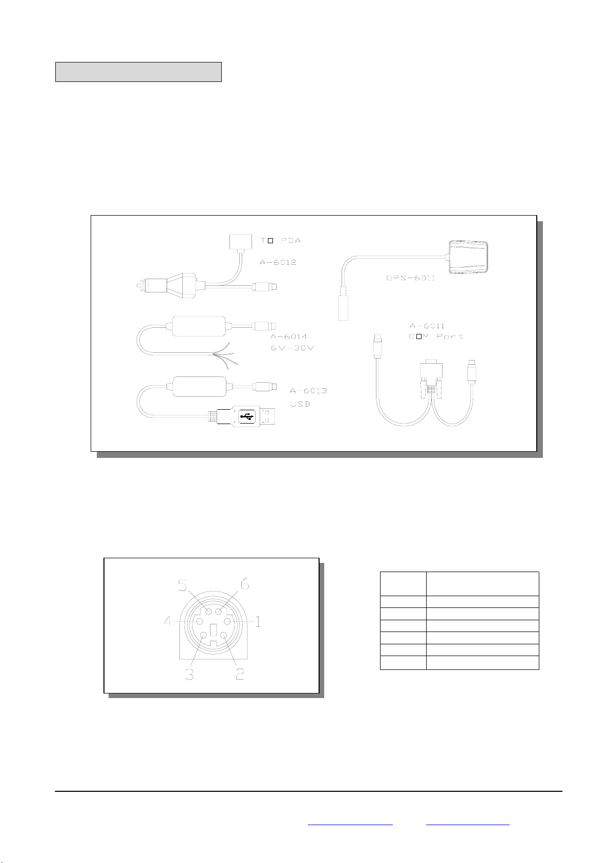
The GPS-6011 includes an antenna in a unique style waterproof gadget. Simply connect PS-2 female
connector to one of the accessories linking to your notebook PC, PDA or other devices. The one-piece cigarette
adapter allows you to connect GPS-6011 to your PDAs. Optional color, input voltage and output connector are
listed and described below:
3.3 Connector
Standard cable: 2 meters with female PS-2 connector.
The GPS-6011 is also equipped with optional connectors cigarette adapter for PDAs.
3.3.1 Function definition of standard PS-2 composite connector
3.4 Accessories
3.4.1 A-6011 Mini Din Female and PS-2 male connector:
Cable Length: To GPS-6011: 1 meter
RS-232 to PS-2: 45 cm
Specifications subject to change without prior notice
Rikaline Marketing Corp.
Tel: ++886 2 2934 5456 Fax: ++886 2 2934 4373 E-mail: info@rikaline.com.tw Web: www.rikaline.com.tw
5F-1, 125, Roosevelt Rd., Sec. 5, Taipei, Taiwan 116
Pin Signal
1 Tx (RS-232)
2 +5VDC
3 Tx (TTL)
4 Ground
5 Rx (TTL)
6 Rx (RS-232)
6
Page 7

Rikaline
g
g
3.4.1.1 Mini Din Female connector function definition:
Pin Si
1 N.C
2 Tx
3 Rx
4 N.C
5 Ground
6 N.C
7 N.C
8 N.C
9 DGPS in
N.C = No connection
3.4.1.2 PS2 composite connector function definition (to PC):
Pin Si
1 +5V
2 N.C
3 N.C
4 Ground
5 N.C
6 N.C
N.C = No connection
3.4.2 A-6012 Cigarette adapter and PDA connector:
Part No. Application Part No. Application
A-6017-A ASUA A-6012-P Palm
A-6017-B BESTA I-WINNA A-6012-Q I-Paq
A-6012-H HP Jornada A-6012-S Sony Series
A-6017-L Siemens LOOX A-6017-T Toshiba Series
A-6017-M Mitac Mio A-6017-X O2-XDA / T-Mobile - MDA
A-6017-N NEC
Specifications subject to change without prior notice
Rikaline Marketing Corp.
Tel: ++886 2 2934 5456 Fax: ++886 2 2934 4373 E-mail: info@rikaline.com.tw Web: www.rikaline.com.tw
5F-1, 125, Roosevelt Rd., Sec. 5, Taipei, Taiwan 116
nal Name
nal Name
7
Page 8

3.4.3 A-6013 USB connector
on Magnet pad
The function definition of the A Type USB connector is as follows:
3.4.4 A-6014 High power connector
Rikaline
Pin Signal Name
1 +5V
2 D +
3 D 4 Ground
Color Signal
Black Ground
Red +6~30 VDC
Green Tx
White Rx
Orange DGPS IN
3.4.5 A-6015 Magnetic Pad (and Mounting Bracket)
The GPS-6011 is also equipped with a standard magnetic pad (Mounting Bracket), A-6015 for being put
on top of the car, a plan surface or mounting on a base used as Mounting Bracket. Fasten 3 screws (Enclosed)
through the magnet pad as a fixed holder.
Top View
Push GPS-6011
Front View
Specifications subject to change without prior notice
Rikaline Marketing Corp.
Tel: ++886 2 2934 5456 Fax: ++886 2 2934 4373 E-mail: info@rikaline.com.tw Web: www.rikaline.com.tw
5F-1, 125, Roosevelt Rd., Sec. 5, Taipei, Taiwan 116
8
Page 9

Rikaline
3.4.6 A-6016 Optional Cigarette Adapter
The optional cigarette adapter with 2-meter core cable is for using in a car or boat. It must be used together
with A-6011.
Input voltage: DC12V - 26V
Specifications subject to change without prior notice
Rikaline Marketing Corp.
Tel: ++886 2 2934 5456 Fax: ++886 2 2934 4373 E-mail: info@rikaline.com.tw Web: www.rikaline.com.tw
5F-1, 125, Roosevelt Rd., Sec. 5, Taipei, Taiwan 116
9
Page 10

Rikaline
4. USB Driver
4.1 System Requirements
IBM, Pentium or above and other compatible PC; 16 MB and above memory; Windows 98/Me/2000; VGA
Graphic Adapter.
4.2 Installation
1. Copy entire <GPS-6011 USB> folder from CD to hard disk.
2. Connect GPS-6011 USB connector to computer. While the computer automatically starts the installation
program, please direct the driver to the <GPS-6011 USB> folder.
3. After the installation is complete, go to <Device Manager> and select <Ports (COM & LPT)> to verify if a
virtual COM port <USB to Serial Port> was created.
4.3 Important
Verify the COM port # to start using your own navigating software.
1. Click <Start> menu, select <Settings>, then enter <Control Panel>.
2. After entering <Control Panel>, select <System>.
3. Select <Device Manager>.
4. Find the <Connect Port> and check the Virtual COM Port, which was created by the USB driver. Please
note that the Virtual COM Port number might be different from every computer. Before using navigating
software, please confirm the COM Port numbers created by your computer and provided by your navigation
software. They must be the same Com Port numbers. Otherwise, the navigating software won’t receive the
satellite signal for the un-match COM Port setting.
Specifications subject to change without prior notice
Rikaline Marketing Corp.
Tel: ++886 2 2934 5456 Fax: ++886 2 2934 4373 E-mail: info@rikaline.com.tw Web: www.rikaline.com.tw
5F-1, 125, Roosevelt Rd., Sec. 5, Taipei, Taiwan 116
10
Page 11

Rikaline
5. Software Interface
The GPS-6011 interface protocol is based on the National Marine Electronics Association's NMEA 0183
ASCⅡ interface specification, which is defined in NMEA 0183, Version 2.2 and the Radio Technical Commission
for Maritime Services (RTCM Recommended Standards For Differential Navstar GPS Service, Version 2.1,
RTCM Special Committee No.104).
5.1 NMEA Transmitted Messages
The GPS-6011 outputs data in NMEA-0183 format as defined by the National Marine Electronics
Association (NMEA), Standard.
The default communication parameters for NMEA output are 4800 baud, 8 data bits, stop bit, and no parity.
Table 5-1 NMEA-0183 Output Messages
NMEA Sentence Description
GPGGA Global positioning system fixed data
GPGLL Geographic position latitude \ longitude
GPGSA GNSS DOP and active satellites
GPGSV GNSS satellites in view.
GPRMC Recommended minimum specific GNSS data
GPVTG Coruse over ground and ground speed
GPZDA Date and Time
5.1.1 Global Positioning System Fix Data (GGA)
Table 5-2 contains the values for the following example:
$GPGGA,161229.487,3723.2475,N,12158.3416,W,1,07,1.0,9.0,M, , , ,0000*18
Table 5-2 GGA Data Format
Name Example Units Description
Message ID $GPGGA GGA protocol header
UTC Time 161229.487 Hhmmss.sss
Latitude 3723.2475 ddmm.mmmm
N/S Indicator N N=north or S=south
Longitude 12158.3416 dddmm.mmmm
E/W Indicator W E=east or W=west
Position Fix Indicator 1 See Table 5-3
Satellites Used 07 Range 0 to 12
HDOP 1.0 Horizontal Dilution of Precision
MSL Altitude 9.0 Meters
Units M Meters
Geoid Separation Meters
Units M Meters
Age of Diff. Corr. second Null fields when DGPS is not used
Diff. Ref. Station ID 0000
Checksum *18
<CR> <LF> End of message termination
Table 5-3 Position Fix Indicator
Value Description
0 0 Fix not available or invalid
1 GPS SPS Mode, fix valid
2 Differential GPS, SPS Mode, fix valid
3 GPS PPS Mode, fix valid
Specifications subject to change without prior notice
Rikaline Marketing Corp.
Tel: ++886 2 2934 5456 Fax: ++886 2 2934 4373 E-mail: info@rikaline.com.tw Web: www.rikaline.com.tw
5F-1, 125, Roosevelt Rd., Sec. 5, Taipei, Taiwan 116
11
Page 12

Rikaline
5.1.2 Geographic Position with Latitude/Longitude (GLL)
Table 5-4 contains the values for the following example:
$GPGLL,3723.2475,N,12158.3416,W,161229.487,A*2C
Table 5-4 GLL Data Format
Name Example Units Description
Message ID $GPGLL GLL protocol header
Latitude 3723.2475 ddmm.mmmm
N/S Indicator N N=north or S=south
Longitude 12158.3416 dddmm.mmmm
E/W Indicator W E=east or W=west
UTC Position 161229.487 hhmmss.sss
Status A A=data valid or V=data not valid
Checksum *2C
<CR> <LF> End of message termination
5.1.3 GNSS DOP and Active Satellites (GSA)
Table 5-5 contains the values for the following example:
$GPGSA,A,3,07,02,26,27,09,04,15, , , , , ,1.8,1.0,1.5*33
Table 5-5 GSA Data Format
Name Example Units Description
Message ID $GPGSA
Mode 1 A See Table 5-6
Mode 2 3
Satellite Used (1) 07 Sv on Channel 1
Satellite Used (1) 02 Sv on Channel 2
…… ….
Satellite Used Sv on Channel 12
PDOP 1.8 Position Dilution of Precision
HDOP 1.0 Horizontal Dilution of Precision
VDOP 1.5 Vertical Dilution of Precision
Checksum *33
<CR> <LF> End of message termination
(1) Satellite used in solution.
Table 5-6 Mode 1
Value Description
M Manual—forced to operate in 2D or 3D mode
A 2D Automatic—allowed to automatically switch 2D/3D
Table 5-7 Mode 2
Value Description
1 Fix Not Available
2 2D
3 3D
5.1.4 GNSS Satellites in View (GSV)
Table 5-8 contains the values for the following example:
$GPGSV,2,1,07,07,79,048,42,02,51,062,43,26,36,256,42,27,27,138,42*71
Rikaline Marketing Corp.
Tel: ++886 2 2934 5456 Fax: ++886 2 2934 4373 E-mail: info@rikaline.com.tw Web: www.rikaline.com.tw
5F-1, 125, Roosevelt Rd., Sec. 5, Taipei, Taiwan 116
GSA protocol header
See Table 5-7
Specifications subject to change without prior notice
12
Page 13

Rikaline
$GPGSV,2,2,07,09,23,313,42,04,19,159,41,15,12,041,42*41
Table 5-8 GSV Data Format
Name Example Units Description
Message ID $GPGSV GSV protocol header
Number of Messages 2 Range 1 to 3
Message Number 1 Range 1 to 3
Satellites in View 07 Range 1 to 12
Satellite ID 07 Channel 1 (Range 1 to 32)
Elevation 79 degrees Channel 1 (Maximum 90)
Azimuth 048 degrees Channel 1 (True, Range 0 to 359)
SNR (C/No) 42 dBHz Range 0 to 99, null when not tracking
.... ....
Satellite ID 27 Channel 4 (Range 1 to 32)
Elevation 27 degrees Channel 4 (Maximum 90)
Azimuth 138 degrees Channel 4 (True, Range 0 to 359)
SNR (C/No) 42 dBHz Range 0 to 99, null when not tracking
Checksum *71
<CR> <LF> End of message termination
NOTE: Items <4>,<5>,<6> and <7> repeat for each satellite in view to a maximum of four (4) satellites per
sentence. Additional satellites in view information must be sent in subsequent sentences. These fields will be
null if unused.
5.1.5 Recommended Minimum Specific GNSS Data (RMC)
Table 5-9 contains the values for the following example:
$GPRMC,161229.487,A,3723.2475,N,12158.3416,W,0.13,309.62,120598, ,*10
Table 5-9 RMC Data Format
Name Example Units Description
Message ID $GPRMC
UTC Time 161229.487 hhmmss.sss
Status A A=data valid or V=data not valid
Latitude 3723.2475 ddmm.mmmm
N/S Indicator N N=north or S=south
Longitude 12158.3416 dddmm.mmmm
E/W Indicator W E=east or W=west
Speed Over Ground 0.13 Knots
Course Over Ground 309.62 Degrees True
Date 120598 ddmmyy
Magnetic Variation Degrees E=east or W=west
Checksum *10
<CR> <LF> End of message termination
5.1.6 Course Over Ground and Ground Speed (VTG)
Table 5-10 contains the values for the following example:
$GPVTG,309.62,T, ,M,0.13,N,0.2,K*6E
Table 5-10 VTG Data Format
Name Example Units Description
Message ID $GPVTG VTG protocol header
Course 309.62 Degrees Measured heading
Reference T True
RMC protocol header
Specifications subject to change without prior notice
Rikaline Marketing Corp.
Tel: ++886 2 2934 5456 Fax: ++886 2 2934 4373 E-mail: info@rikaline.com.tw Web: www.rikaline.com.tw
5F-1, 125, Roosevelt Rd., Sec. 5, Taipei, Taiwan 116
13
Page 14

Rikaline
Course Degrees Measured heading
Reference M Magnetic (1)
Speed 0.13 Knots Measured horizontal speed
Units N Knots
Speed 0.2 Km/hr Measured horizontal speed
Units K Kilometers per hour
Checksum *6E
<CR> <LF> End of message termination
(1) All “course over ground” data are geodetic WGS84 directions.
5.1.7 Time & Date (ZDA)
Table 5-11 contains the values for the following example:
$GPVTG,114523.62,12,04,2001,10,34*6E
Table 5-11 zda Data Format
Name Example Units Description
Message ID $GPZDA ZDA protocol header
Hour, Min, Sec, Sub
Sec
Day 12 Day in UTC, 01to 12
Month 04 Month in UTC, 01 to 12
Year 2001 Year in UTC
Local Zone Hours 10 Local zone hours, +/- 13 hours
Local Zone Minutes 34
Checksum *6E
<CR> <LF> End of message termination
5.2 RTCM Received Data
The default communication parameters for DGPS Input are 9600 baud, 8 data bits, stop bit, and no parity.
Position accuracy of less than 5 meters can be achieved with the GPS-6011 by using Differential GPS (DGPS)
real-time pseudo-range correction data in RTCM SC-104 format, with message types 1, 5, or 9. As using
DGPS receiver with different communication parameters, GPS-6011 may decode the data correctly to generate
accurate messages and save them in battery-back SRAM for later computing.
114523.62 Hhmmss.ss
Local zone minutes, 0 to +59
Specifications subject to change without prior notice
Rikaline Marketing Corp.
Tel: ++886 2 2934 5456 Fax: ++886 2 2934 4373 E-mail: info@rikaline.com.tw Web: www.rikaline.com.tw
5F-1, 125, Roosevelt Rd., Sec. 5, Taipei, Taiwan 116
14
Page 15

6. Earth Datums
6.1 Earth Datums
The following is a list of the GPS-6011 earth datum index
Item Datum Reference Ellipsoid
0 ADINDAN Ethiopia, Mali, Senegal, Sudan
1 AFGOOYE Somalia
2 AIN EL ABD 1970 Bahrain Island, Saudi Arabia
3 ANNA 1 ASTRO 1965 Cocos Island
4 ARC 1950 Botswana, Lesotho, Malawi, Swaziland, Zaire, Zaire,
5 ARC 1960 Kenya, Tanzania
6 Ascension Island 1958 Ascension Island
7 ASTRO BEACON “E” Iwo Jima Island
8 AUSTRALIAN GEODETIC 1966 Australia, Tasmania Island
9 AUSTRALIAN GEODETIC 1984 Australia, Tasmania Island
10 ASTRO DOS 71/4 St. Helena Island
11 ASTRONOMIC STATION 1952 Marcus Island
12 ASTRO B4 SOROL ATOLL Tern Island
13 BELLEVUE (IGN) Efate and Erromango Islands
14 BERMUDA 1957 Bermuda Islands
15 BOGOTA OBSERVATORY Colombia
16 CAMPO INCHAUSPE Argentina
17 CANTON ASTRO 1966 Phoenix Islands
18 CAPE CANAVERAL Florida, Bahama Islands
19 CAPE South Africa
20 CARTHAGE Tunisia
21 CHATHAM 1971 Chatham Island (New Zealand)
22 CHUA ASTRO Paraguay
23 CORREGO ALEGRE Brazil
24 DJAKARTA (BATAVIA) Sumatra Island (Indonesia)
25 DOS 1968 Gizo Island (New Georgia Islands)
26 EASTER ISLAND 1967 Easter Island
27 EUROPEAN 1950 Austria, Belgium, Denmark, Finland, France, Germany,
28 EUROPEAN 1979 Austria, Finland, Netherlands, Norway, Spain, Sweden
29 FINLAND HAYFORD 1910 Finland
30 GANDAJIKA BASE Republic of Maldives
31 GEODETIC DATUM 1949 New Zealand
32 ORDNANCE SURVEY OF
GREAT BRITAIN 1936
33 GUAM 1963 Guam Island
34 GUX 1 ASTRO Guadalcanal Island
35 HJORSEY 1955 Iceland
36 HONG KONG 1963 Hong Kong
37 INDIAN Bangladesh, India, Nepal
38 INDIAN Thailand, Vietnam
39 IRELAND 1965 Ireland
40 ISTS 073 ASTRO 1969 Diego Garcia
41 JOHNSTON ISLAND 1961 Johnston Island
42 KANDAWALA Sri Lanka
43 KERGUELEN ISLAND Kerguelen Island
44 KERTAU 1948 West Malaysia, Singapore
Rikaline
Zambia, Zimbabwe
Gibraltar, Greece, Italy, Luxembourg, Netherlands,
Norway, Portugal, Spain, Sweden Switzerland
Switzerland
England, Isle of Man, Scotland, Shetland Islands, Wales
Specifications subject to change without prior notice
Rikaline Marketing Corp.
Tel: ++886 2 2934 5456 Fax: ++886 2 2934 4373 E-mail: info@rikaline.com.tw Web: www.rikaline.com.tw
5F-1, 125, Roosevelt Rd., Sec. 5, Taipei, Taiwan 116
15
Page 16

Rikaline
45 L.C. 5 ASTRO Cayman Brac Island
46 LIBERIA 1964 Liberia
47 LUZON Mindanao Island
48 LUZON Philippines (excluding Mindanao Island)
49 MAHE 1971 Mahe Island
50 MARCO ASTRO Salvage Islands
51 MASSAWA Eritrea (Ethiopia)
52 MERCHICH Morocco
53 MIDWAY ASRTO 1961 Midway Island
54 MINNA Nigeria
55 NORTH AMERICAN 1927 Alaska
56 NORTH AMERICAN 1927 Bahamas (excluding San Salvador Island)
57 NORTH AMERICAN 1927 Central America (Belize, Costa Rica, El Salvador,
Guatemala, Honduras, Nicaragua)
58 NORTH AMERICAN 1927 Canal Zone
59 NORTH AMERICAN 1927 Canada (including Newfoundland Island)
60 NORTH AMERICAN 1927 Caribbean (Barbados, Caicos Islands, Cuba, Dominican
Republic, Grand Cayman, Jamaica, Leeward Islands,
Turks Islands)
61 NORTH AMERICAN 1927 Mean Value (CONUS)
62 NORTH AMERICAN 1927 Cuba
63 NORTH AMERICAN 1927 Greenland (Hayes Peninsula)
64 NORTH AMERICAN 1927 Mexico
65 NORTH AMERICAN 1927 San Salvador Island
66 NORTH AMERICAN 1983 Alaska, Canada, Central America, CONUS, Mexico
67 NAPARIMA, BWI Trinidad and Tobago
68 NAHRWAN Masirah Island (Oman)
69 NAHRWAN Saudi Arabia
70 NAHRWAN United Arab Emirates
71 OBSERVATORIO 1966 Corvo and Flores Islands (Azores)
72 OLD EGYPTIAN Egypt
73 OLD HAWAIIAN Mean Value
74 OMAN Oman
75 PICO DE LAS NIEVES Canary Islands
76 PITCAIRN ASTRO 1967 Pitcairn Island
77 PUERTO RICO Puerto Rico, Virgin Islands
78 QATAR NATIONAL Qatar
79 QORNOQ South Greenland
80 REUNION Mascarene Island
81 ROME 1940 Sardinia Island
82 RT 90 Sweden
83 PROVISIONAL SOUTH
AMERICAN 1956
84 SOUTH AMERICAN 1969 Argentina, Bolivia, Brazil, Chile, Colombia, Ecuador,
85 SOUTH ASIA Singapore
86 PROVISIONAL SOUTH CHILEAN
1963
87 SANTO (DOS) Espirito Santo Island
88 SAO BRAZ Sao Miguel, Santa Maria Islands (Azores)
89 SAPPER HILL1943 East Falkland Island
90 SCHWARZECK Namibia
91 SOUTHEAST BASE Porto Santo and Madeira Islands
92 SOUTHWEST BASE Faial, Graciosa, Pico, Sao Jorge, and Terceira Islands
93 TIMBALAI 1948 Brunei and East Malaysia (Sarawak and Sabah)
94 TOKYO Japan, Korea, Okinawa
Bolivia, Chile, Colombia, Ecuador, Guyana, Peru,
Venezuela
Guyana, Paraguay, Peru, Venezuela, Trinidad and Tobago
South Chile
(Azores)
Specifications subject to change without prior notice
Rikaline Marketing Corp.
Tel: ++886 2 2934 5456 Fax: ++886 2 2934 4373 E-mail: info@rikaline.com.tw Web: www.rikaline.com.tw
5F-1, 125, Roosevelt Rd., Sec. 5, Taipei, Taiwan 116
16
Page 17

95 TRISTAN ASTRO 1968 Tristan da Cunha
96 USER DEFINED EARTH DATUM
97 VITI LEVU 1916 Viti Levu Island (Fiji Islands)
98 WAKE-ENIWETOK 1960 Marshall Islands
99 WORLD GEODETIC SYSTEM
1972
100 WORLD GEODETIC SYSTEM
1984
101 ZANDERIJ Surinam
102 CH-1903 Switzerland
103 HU-TZU Shan
104 INDONESIA 74
105 AUSTRIA
106 POTSDAM
107 TAIWAN (Modified Hu-Tzu-Shan)
6.2 Setting Syntax
6.2.1 Manufacturing Default:
Datum: WGS84.
Baud Rate: 4800.
Output: GGA, GSA, GSV, RMC.
6.2.2 Datum change syntax:
Please refer separate instruction.
Rikaline
Specifications subject to change without prior notice
Rikaline Marketing Corp.
Tel: ++886 2 2934 5456 Fax: ++886 2 2934 4373 E-mail: info@rikaline.com.tw Web: www.rikaline.com.tw
5F-1, 125, Roosevelt Rd., Sec. 5, Taipei, Taiwan 116
17
Page 18

7. Ordering Information
7.1 Product Options
7.1.1 Output Level (or Data)
GPS-6011: RS-232 & TTL
7.1.2 Color Option
BK Black (Standard)
Other Color: by demand
7.2 Accessories
A-6011 Com Port connector (Standard, packed in color box)
A-6013 USB connector
A-6014 High power connector, 6-30VDC
A-6015 Magnetic pad
A-6016 Cigarette adapter
A-6012 / 6017 PDA connector with Cigarette Adapter
Part No. PDA
1 A-6017-A ASUS A-600
2 A-6017-B BESTA I-WINNA
3 A-6012-C Casio E-115
4 A-6012-C1 Casio E-125
5 A-6012-C2 Casio E-200
6 A-6012-H HP Jornada 565/568
7 A-6012-HS HandSpring Treo
8 A-6012-HS1 HandSpring Visor\Prism
9 A-6012-HS2 HandSpring Edge
10 A-6017-L Siemens LOOX
11 A-6017-M Mitac Mio 528
12 A-6017-N NEC 300E
13 A-6012-P Palm Vx
14 A-6012-P1 Palm / IBM WorkPad 500/505
15 A-6012-Q I-Paq 36xx
16 A-6012-Q1 I-Paq 38xx
17 A-6017-Q1 I-Paq 38xx
18 A-6012-S Sony N-7xx
19 A-6012-S1 Sony T-6xx
20 A-6017-SM Siemens SX-45
21 A-6012-T1 Toshiba E-570
22 A-6017-T2 Toshiba E-330/740
23 A-6017-X O 2 – XDA / T-Mobiles – MDA
Remarks: A-6012 series is 500mA
A-6017 series is 2A
7.3 Products Combination
7.3.1 Standard package
GPS-6011 (GPS Receiver) + A-6011 (ComPort & PS-2 Connector)
7.3.2 Other Combination for GPS Application
7.3.2.1 Popular GPS Application
GPS-6011 + GPS system for Tracking, Security, Fleet Management…and so on
7.3.2.2 Navigation
Rikaline
Specifications subject to change without prior notice
Rikaline Marketing Corp.
Tel: ++886 2 2934 5456 Fax: ++886 2 2934 4373 E-mail: info@rikaline.com.tw Web: www.rikaline.com.tw
5F-1, 125, Roosevelt Rd., Sec. 5, Taipei, Taiwan 116
18
Page 19

Rikaline
GPS-6011 Notebook PC Navigation (COM version)
GPS-6011 + A-6013 Notebook Notebook PC Navigation (USB version)
GPS-6011 + A-6012 PDA Navigation
8. Warranty
The GPS-6011 is warranted to be free from defects in material and functions for one year from the date of
purchase. Any failure of this product within this period under normal conditions will be replaced at no charge to
the customers.
Specifications subject to change without prior notice
Rikaline Marketing Corp.
Tel: ++886 2 2934 5456 Fax: ++886 2 2934 4373 E-mail: info@rikaline.com.tw Web: www.rikaline.com.tw
5F-1, 125, Roosevelt Rd., Sec. 5, Taipei, Taiwan 116
19
 Loading...