

Garmin Oregon 200, Oregon 300, Oregon 400c, Oregon 400i, Oregon 400t Owner Manual
...
OREGON
200, 300, 400t, 400c, 400i, 550, 550t
owner’s manual
™
series

© 2009 Garmin Ltd. or its subsidiaries
Garmin International, Inc.
1200 East 151st Street,
Olathe, Kansas 66062, USA
Tel. (913) 397.8200 or
(800) 800.1020
Fax (913) 397.8282
Garmin (Europe) Ltd.
Liberty House
Hounsdown Business Park,
Southampton, Hampshire,
SO40 9RB UK
Tel. +44 (0) 870.8501241 (outside the UK)
0808 2380000 (within the UK)
Garmin Corporation
No. 68, Jangshu 2nd
Road,
Shijr, Taipei County,
Taiwan
Tel. 886/2.2642.9199
Fax 886/2.2642.9099
Fax +44 (0) 870.8501251
All rights reserved. Except as expressly provided herein, no part of this manual may be reproduced,
copied, transmitted, disseminated, downloaded or stored in any storage medium, for any purpose without
the express prior written consent of Garmin. Garmin hereby grants permission to download a single copy
of this manual onto a hard drive or other electronic storage medium to be viewed and to print one copy of
this manual or of any revision hereto, provided that such electronic or printed copy of this manual must
contain the complete text of this copyright notice and provided further that any unauthorized commercial
distribution of this manual or any revision hereto is strictly prohibited.
Information in this document is subject to change without notice. Garmin reserves the right to change
or improve its products and to make changes in the content without obligation to notify any person
or organization of such changes or improvements. Visit the Garmin Web site (www.garmin.com) for
current updates and supplemental information concerning the use and operation of this and other Garmin
products.
Garmin® , MapSource
USA and other countries. Oregon™, Colorado™, and myGarmin™ are trademarks of Garmin Ltd. or its
subsidiaries. These trademarks may not be used without the express permission of Garmin.
The Geocaching 4-box logo and the Wherigo logo are registered trademarks of Groundspeak Inc., in the
United States and other countries. Used with permission. Use of geocaching.com data is subject to the
Geocaching.com Terms of Use Agreement located at www.geocaching.com/about/termsofuse.aspx. The
Wherigo application is covered by patent 6,691,032 and US and foreign patents pending. Windows® is a
registered trademark of Microsoft Corporation in the United States and/or other countries. Mac
®,
BlueChart® g2 are trademarks of Garmin Ltd. or its subsidiaries, registered in the
®
OS is a
registered trademarks of Apple Computer, Inc. microSD™ is a trademark of SanDisk or its subsidiaries.
April 2009 Part Number 190-01070-00 Rev. C Printed in Taiwan
Introduction
Introduction
This manual provides instructions for
using the following products:
Oregon™ 200
•
Oregon 300
•
Oregon 400t, 400c, and 400i
•
Oregon 550 and 550t
•
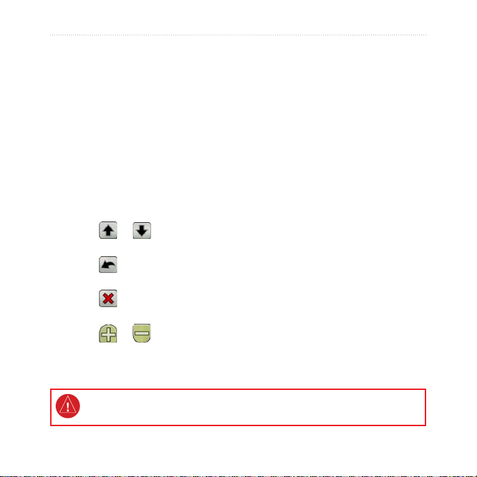
Tips and Shortcuts
Touch or to scroll and
•
see more choices.
Touch to return to the
•
previous screen.
Touch to return to the Main
•
menu.
Touch or on the Map
•
page to zoom in or zoom out.
See the Important Safety and Product Information guide in the product box for
product warnings and other important information.
Oregon Series Owner’s Manual i
Manual Conventions
When you are instructed to “touch”
something, use your nger to touch
that item on the screen.
The small arrows (>) used in the
text indicate that you should touch a
series of items in order. For example,
if you see, “Touch Where To?
> Tracks,” you should touch the
Where To? button on the screen, and
then touch Tracks.
Product Registration
Help us better support you by
completing our online registration
today. Connect to our Web site at
http://my.garmin.com. Keep the
original sales receipt, or a photocopy,
in a safe place.

Contact Garmin
Contact Garmin Product Support if
you have any questions while using
your Oregon. In the USA, go to
www.garmin.com/support, or contact
Garmin USA by phone at (913)
397.8200 or (800) 800.1020.
In the UK, contact Garmin (Europe)
Ltd. by phone at 0808 2380000.
In Europe, go to www.garmin.com
/support and click Contact Support
for in-country support information,
or contact Garmin (Europe) Ltd. by
phone at +44 (0) 870.8501241.
If needed, the serial number of your
Oregon is located in the battery
compartment. Remove batteries as
indicated on page 2.
ii Oregon Series Owner’s Manual
Optional Accessories
For a list of available accessories and
maps, refer to the Garmin Web site at
http://buy.garmin.com.

Oregon Series Features
Features 200 300 400t 400c 400i 550 550t
US Inland Lakes
Mapping
US, UK, or Aus
BlueChart
Mapping
US, European,
Aus, or Canada
Topography
Altimeter No Yes Yes Yes Yes Yes Yes
Audio Tones No Yes Yes Yes Yes Yes Yes
Wireless
Communication
RS-232/NMEA
Serial
Alarm Clock No Yes Yes Yes Yes Yes Yes
3-Axis Compass
2-Axis CompassNoNo
Camera No No No No No Yes Yes
High-Speed USB No No No No No Yes Yes
Optional Optional Optional Optional Yes Optional Optional
Optional Optional Optional Yes Optional Optional Optional
Optional Optional Yes Optional Optional Optional Yes
No Yes Yes Yes Yes Yes Yes
No Yes Yes Yes Yes Yes Yes
No
Yes
No
Yes
No
Yes
No
Yes
YesNoYes
No
Oregon Series Owner’s Manual iii

Table of Contents
Introduction .......................... i
Tips and Shortcuts .......................i
Manual Conventions ....................i
Product Registration ....................i
Contact Garmin ..........................ii
Optional Accessories ..................ii
Oregon Series Features ............ iii
Caring for the Oregon ................vi
Getting Started .................... 1
Battery Information .................... 2
Turning On and
Off the Oregon ........................ 2
Adjusting the Backlight Level..... 3
Acquiring GPS
Satellite Signals ...................... 3
Locking the Screen .................... 3
Basic Navigation................. 4
Accessing Applications from the
Main menu .............................. 4
Creating Waypoints ................... 4
Navigating to a Destination........ 5
Stop Navigating ......................... 7
iv Oregon Series Owner’s Manual
Using the Map .......................... 7
Using the Compass ................... 9
Bearing and Course
Pointers ..................................11
Managing Waypoints,
Routes, and Tracks........... 13
Modifying Waypoints ............... 13
Creating Routes....................... 14
Viewing Stored Routes ............ 14
Editing and Deleting Routes .... 14
Viewing the Active Route ......... 15
Managing Tracks ..................... 15
Additional Tools ................ 17
Elevation Plot........................... 17
Sharing Information
Wirelessly .............................. 18
Using the Camera.................... 19
Viewing Images ....................... 20
Calculating the
Size of an Area ...................... 20
Other Tools .............................. 21
Monitoring Satellite
Reception .............................. 21

Trip Computer .......................... 22
GPS Games ....................... 23
Geocaches .............................. 23
Wherigo™ ................................ 23
Customizing the Oregon .. 24
Changing the Prole ................ 24
Setting Up Proles ................... 24
Using System Setup ................ 25
Customizing the Display .......... 26
Map Setup ............................... 26
Tracks Setup ........................... 27
Customizing the Main menu .... 28
Routing Setup .......................... 28
Changing the Camera
Settings ................................. 29
Changing Marine Settings ....... 29
Changing Time Settings .......... 30
Changing Measurement
Units ...................................... 30
Position Format ....................... 31
Modifying the Compass ........... 31
Altimeter Setup ........................ 32
Pairing the Oregon .................. 33
Oregon Series Owner’s Manual v
Reset ....................................... 34
Viewing Your Oregon
Information ............................ 34
Appendix ........................... 35
Specications .......................... 35
Using Demo Mode ................... 36
Connecting Your Oregon to a
Computer .............................. 37
Installing a microSD™ Card ...... 37
Transferring Tracks, Routes, or
Waypoints ............................. 38
Loading and Deleting Files ...... 39
Optimizing Battery Life ............ 39
Restoring Factory Default
Settings ................................. 40
Attaching the Carabiner ........... 41
Calibrating the
Touchscreen .......................... 41
Software License
Agreement ............................ 42
Declaration of
Conformity (DoC) .................. 42
Index .................................. 43

Caring for the Oregon
Cleaning the case
Use a cloth dampened with a mild
detergent solution, and then wipe it
dry. Avoid cleaners that may damage
Cleaning the camera lens
Clean the lens only when necessary.
Use a soft lens cloth. Apply lens
cleaning uid to the cloth and gently
wipe the screen with the cloth.
the plastic components.
Cleaning the screen
Use a soft, clean, lint-free cloth. Use
water, isopropyl alcohol, or eyeglass
lens cleaner. Apply the liquid to the
cloth and then gently wipe the screen
with the cloth.
vi Oregon Series Owner’s Manual
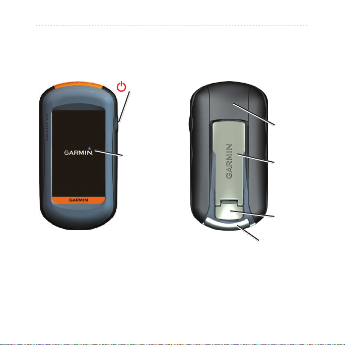
Getting Started
Power key
Getting Started
Battery
cover
Touchscreen
mini-USB connector
(under weather cap)
Oregon Series Owner’s Manual 1
Mounting
spine
Latch
Getting Started
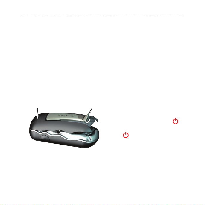
Battery Information
Oregon units operate on two AA
batteries. Use alkaline, NiMH, or
lithium batteries. Use precharged
NiMH or lithium batteries for best
results. Standard alkaline batteries
are not recommended for Oregon 550
units when using the camera feature.
To install the batteries:
1.
Lift the latch and remove the
battery cover.
Battery cover
Latch
To select the battery type:
1. Touch Setup > System > Battery
Type.
2. Touch
Alkaline, Lithium,
Rechargeable NiMH, or
Pre-Charged NiMH.
Long-Term Storage
Remove batteries when you do not
plan to use the Oregon for several
months. Stored data is not lost when
batteries are removed.
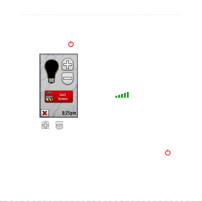
Turning On and Off the Oregon
1. To turn on the Oregon, press .
2. To turn off the Oregon, press and
hold .
2. Insert the batteries, observing
polarity.
3. Replace the battery cover and
push the latch down.
2 Oregon Series Owner’s Manual
Getting Started
Adjusting the Backlight Level
1. While the Oregon is on, press
and quickly release .
Acquiring GPS Satellite Signals
Before the Oregon can nd your
current location and navigate a route,
you must acquire GPS signals.
1. Go outdoors to an open area,
away from tall buildings and trees.
2. Turn on the Oregon. Acquiring
satellite signals can take a few
minutes.
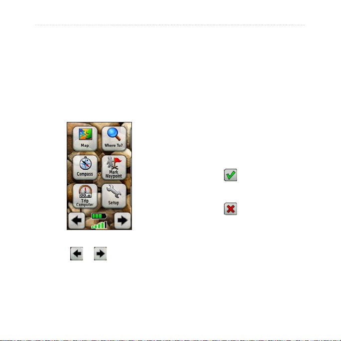
The bars on the Main menu
indicate satellite strength. When
the bars are green, the Oregon has
acquired satellite signals.
2. Touch or to adjust the
brightness levels.
See (page 26) to change the
backlight timeout.
Oregon Series Owner’s Manual 3
Locking the Screen
Lock the screen to prevent
inadvertent screen touches.
1. Press and quickly release .
2. Touch
Lock Screen (or Unlock
Screen).
Basic Navigation
Basic Navigation
Creating Waypoints
Waypoints are locations you record
Accessing Applications from the Main menu
You can access all Oregon
applications from the Main menu.
Main menu
Touch or to access
additional applications.
4 Oregon Series Owner’s Manual
and store in the Oregon.
To mark your current location as
a waypoint:
1. Touch Mark Waypoint.
2. Touch
3. Touch an item from the list to
Save and Edit.
change.
Touch letters, numbers, or
•
symbols to make the changes.
Touch (except when
•
changing a symbol). Change
other attributes, if necessary.
Touch to discard the
•
changes.
To edit or delete a waypoint, see
page 13.

Navigating to a Destination
You can use Where To? or choose
a point on the map to navigate to a
destination with the Oregon.
NOTE: Depending on your
device, you may not see all of the
options listed below. See page
(page iii) for a list of features
available on your device.
To navigate to a destination
using Where To?:
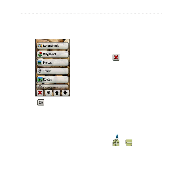
1. Touch Where To?.
2. Touch a category.
3. Touch one of the following items:
Recent Finds—items you
•
have recently found.
Waypoints—a list of
•
waypoints (page 4).
Photos—a list of geotagged
•
pictures (the pictures contain
location data) (page 19).
Basic Navigation
Tracks—a list of tracks
•
(page 15).
Geocaches—a list of
•
downloaded geocaches
(page 23).
Routes—a list of routes
•
(page 14).
All POI (Points of Interest)—if
•
supported by the preloaded
or optional mapping, various
Points of Interest may be
listed.
Cities—a list of the 50 closest
•
cities to your current location.
4. Touch
5. Touch
6. Use the compass to navigate to
Go. A colored line indicates
your course.
> Compass.
your destination.
Oregon Series Owner’s Manual 5
Basic Navigation
To nd a destination by spelling
the name:
1. On the Main menu, touch Where
To? > All POI.
2. Touch
.
3. Touch characters to spell a part of
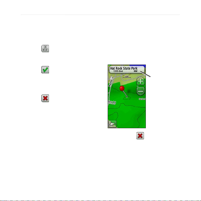
To navigate to a point on the
map:
1. Touch Map.
2. Touch a point on the map.
3. Touch the information button at
the top of the screen.
the name of your destination.
4. Touch
5. Touch the destination.
6. Touch
.
Go. A colored line indicates
Information
button
your course.
7. Touch
> Compass.
8. Use the compass to navigate to
your destination as indicated on
page 9.
4. Touch
Go > > Compass.
5. Use the compass to navigate to
your destination as indicated on
page 9.
6 Oregon Series Owner’s Manual
Basic Navigation
To navigate to a destination near
a waypoint or a recent nd:
1. Touch Where To?.
5. Touch a category. Items are listed
in order of distance from the
location you selected.
6. Touch a destination.
7. Touch
8. Touch
9. Use the compass to navigate to
Go. A colored line indicates
your course.
> Compass.
your destination as indicated on
page 9.
Stop Navigating
To stop navigating, touch Where
2. Touch .
3. Select from the following options:
A Recent Find
•
A Waypoint.
•
My Current Location
•
A Map Point
•
4. Touch the location you want to
search near.
Oregon Series Owner’s Manual 7
To? > Stop Navigation.
Using the Map
To use the map:
1. Touch Map. Your current location
is indicated by a location
marker .
2. Touch
3. Touch and drag the screen to pan
or to zoom.
the map.
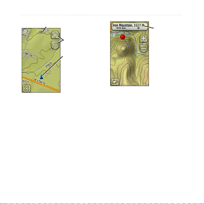
Basic Navigation
Zoom range
Information
button
Zoom buttons
Location marker
Map Page
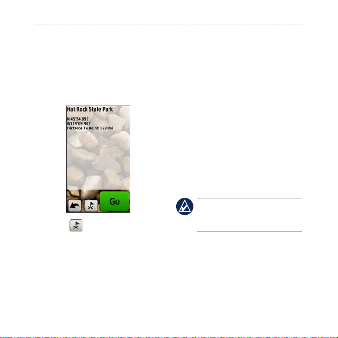
To review detailed information
about a point on the map:
1. If necessary, pan to the location
you want to review.
2. Touch the location.
3. Touch the information button at
the top of the screen for additional
information.
To show or hide data elds at
the top of the screen:
1. Touch Setup > Map > Show Data
Fields.
2. Touch
Never, When Navigating,
or Always.
To change the Map page data
elds:
1. On the Map page, touch one of
the data elds.
2. Touch a data type.
8 Oregon Series Owner’s Manual
Basic Navigation
To save a waypoint on the Map
page:
1. On the Map page, touch the point
you want to save.
2. Touch the information button at
the top of the screen.
as current speed, distance to the next
point on the route, and estimated
arrival time.
The electronic compass (Oregon 300,
400t, 400c, 400i, 550, and 550t) is
similar to a magnetic compass when
you are stationary or walking. If you
maintain a higher speed, such as
traveling in automobile, the compass
uses GPS signals to determine your
direction. To turn the electronic
compass off, see page 31. Hold the
compass level when navigating to
ensure maximum accuracy.
NOTE: Holding the compass
level is not necessary if you are
3. Touch to save the waypoint.
Using the Compass
The Compass page guides you to
using an Oregon 550 or 550t.
To open the Compass page:
Touch Compass.
your destination by displaying a
compass and a bearing pointer.
It also provides navigation data such
Oregon Series Owner’s Manual 9
 Loading...