

Owner’s Manual

© Copyright 2005 Garmin Ltd. or its subsidiaries
Garmin International, Inc.
1200 East 151st Street,
Olathe, Kansas 66062, U.S.A.
Tel. 913/397.8200 or 800/800.1020
Fax 913/397.8282
All rights reserved. Except as expressly provided herein, no part of this manual may be reproduced, copied, transmitted, disseminated, downloaded or
stored in any storage medium, for any purpose without the express prior written consent of DaimlerChrysler Motors Company, LLC and Garmin.
Information in this document is subject to change without notice. DaimlerChrysler Corporation reserves the right to change or improve its products and
to make changes in the content without obligation to notify any person or organization of such changes or improvements. Visit the Garmin Web site at
www.garmin.com/products/navus for current updates and supplemental information concerning the use and operation of this unit.
Garmin® and AutoLocate® are registered trademarks of Garmin Ltd. or its subsidiaries and may not be used without the express permission of Garmin.
Navus™ is a trademark of DaimlerChrysler Corporation.
March 2005 Part Number 190-00539-00 Rev. A Printed in Taiwan
Unit 5, The Quadrangle, Abbey Park Industrial
Garmin (Europe) Ltd.
Estate, Romsey, SO51 9DL, U.K.
Tel. 44/0870.8501241
Fax 44/0870.8501251
Garmin Corporation
No. 68, Jangshu 2nd Road, Shijr, Taipei County,
Taiwan
Tel. 886/2.2642.9199
Fax 886/2.2642.9099

INTRODUCTION > PREFACE
INTRODUCTION
Congratulations on purchasing the Navus™! To get the most out of
your new navigation system, take the time to go through this Owner’s
Manual and learn the operating procedures for your unit.
Contact Garmin
If you should encounter any difficulty while using your Navus, or
if you have any questions, in the U.S.A. contact Garmin Product
Support at 913/397.8200 or 800/800.1020, Monday–Friday, 8 AM–5
PM Central Time; or by e-mail at sales@garmin.com. In Europe,
contact Garmin (Europe) Ltd. at 44/0870.8501241.
Your Navus Uses Safe Mode Technology
The Navus is equipped with a Safe Mode feature to improve driver
safety. When your vehicle is moving, Safe Mode disables all
functions that require significant operator attention and could become
a distraction while driving.
Quick Tips
• To find an address, page 26.
• To understand information on the Map page, pages 9–17.
• To use the Navus in “practice” (simulator) mode, page 8.
• To learn more about GPS, page 56.
• To learn safety information, pages 1–2.
i
For replacement parts or accessories, visit www.garmin.com
/products/navus.
Keep Your Navus’s Serial Number
Record the serial number in case your unit is lost, stolen, or needs
service. This 8-digit number is located below the Compact Flash (CF)
card on the passenger’s side of the unit. Open the CF door to view the
number. See page 61 for more information.
Serial Number: ___ ___ ___ ___ ___ ___ ___ ___

INTRODUCTION > TABLE OF CONTENTS
Introduction ........................................................................................... i
Your Navus Uses Safe Mode Technology ...................................................................i
Quick Tips ...................................................................................................................
Contact Garmin ...........................................................................................................i
Keep Your Navus’s Serial Number ..............................................................................i
Caring for Your Navus ...................................................................................................
Cleaning the Touchscreen ..........................................................................................4
Cleaning the Casing ...................................................................................................4
Safety Guidelines ..........................................................................................................1
Getting Started ..................................................................................... 3
Introducing the Navus ....................................................................................................3
Navigation at a Glance ..................................................................................................4
Navus Basics .................................................................................................................6
Turning the Navus On and Off ...................................................................................
Using the Keys ...........................................................................................................6
Using the Touchscreen ...............................................................................................
Adjusting the Speaker Volume ...................................................................................7
Using the On-screen Keyboard ..................................................................................8
Practice Using the Navus in Simulator Mode .............................................................8
Navus Operation .................................................................................. 9
Learning How to Use the Map Page ..............................................................................9
Viewing the Map Page for the First Time ...................................................................
ii
i
4
6
7
9
Map Page Features .................................................................................................10
Driving and Routing Modes ......................................................................................16
Changing the Map View While Driving .....................................................................17
Looking Ahead on the Map Page .............................................................................
Next Turn Page ............................................................................................................
Current Route Page .....................................................................................................19
Trip Information Page ..................................................................................................
Data Displayed on the Trip Information Page ..........................................................22
17
18
20
Finding Places and Routing to Them .............................................. 23
Finding Places to Visit .................................................................................................23
Route Preference Window .......................................................................................24
Other Ways to Find
Filtering Results .......................................................................................................25
Finding Addresses or Intersections .............................................................................26
Refining Your Search ...............................................................................................
Finding Cities ...............................................................................................................28
Finding Exits ................................................................................................................28
Other Ways to Find Exits .........................................................................................29
Finding Waypoints .......................................................................................................
Finding “Recent Finds” ................................................................................................30
Other Ways to find “Recent Finds” ...........................................................................30
Deleting Recent Finds ..............................................................................................30
Places ......................................................................................24
27
29

INTRODUCTION > TABLE OF CONTENTS
Planning a Trip Using Find Features ...........................................................................31
Planning and Modifying Routes ....................................................... 32
Planning a Route .........................................................................................................32
Saving a Route ........................................................................................................33
Deleting or Renaming a Saved Route .....................................................................34
Modifying a Route ........................................................................................................35
Recalculating a Route ..............................................................................................35
Adding a Detour .......................................................................................................35
Adding Extra Stops (Trip Itinerary) ...........................................................................36
Adding Avoidances ...................................................................................................38
Setting a HOME Waypoint ...........................................................................................40
Changing Your HOME Waypoint ..............................................................................
41
Customizing Your Navus .................................................................. 42
Customizing the Map Page .........................................................................................42
Map Tab ...................................................................................................................43
Line, Point, City, and Area Tabs ...............................................................................
Resetting Map Setup Default Settings .....................................................................44
Changing the Data Tabs ..............................................................................................45
Customizing the Overall Setup ....................................................................................48
Restoring your Navus’s
General Tab ..............................................................................................................
Guidance Tab ...........................................................................................................
Original Settings ................................................................. 48
43
49
50
iii
Routing Tab ..............................................................................................................
Time Tab ..................................................................................................................
Language Tab ..........................................................................................................
Display Tab ...............................................................................................................54
Customizing the Trail Logs ..........................................................................................55
Appendix ............................................................................................ 56
What is GPS? ..............................................................................................................56
The GPS Information Page ......................................................................................56
Satellite Status .........................................................................................................58
“Poor Satellite Reception” Menu ..............................................................................59
GPS Information Page Options ................................................................................59
Driving with Dead Reckoning ...................................................................................60
Installing the CF Card ..................................................................................................61
Viewing
Map Information .............................................................................................62
Purchasing Additional Map Data .............................................................................
Viewing
Software Information ......................................................................................63
FCC Compliance ........................................................................................................64
Software License Agreement .......................................................................................
The Mopar Warranty Difference ..................................................................................
50
53
54
63
65
66

INTRODUCTION > CARING FOR YOUR NAVUS
Caring for Your Navus
The Navus is constructed of high quality materials and does not
require user maintenance other than cleaning.
Cleaning the Touchscreen
The Navus touchscreen is intended primarily for finger operation.
Although a PDA stylus may also be used to operate the touchscreen,
never attempt this while operating a vehicle. Never use a hard or
sharp object to operate the touchscreen or damage may result. Use a
clean, dry lens cloth to remove dust from the touchscreen. Carefully
wipe the display to prevent scratches. Water, isopropyl alcohol, or
eyeglass cleaner can be used if needed. If they are used, apply the
liquid to the cloth and then gently wipe the touchscreen with the
moistened cloth.
iv
Cleaning the Casing
The outer casing of your Navus is constructed of high quality
materials and does not require user maintenance other than cleaning.
Clean the outer casing using a cloth dampened with a mild detergent
solution and then wipe dry. Avoid chemical cleaners and solvents that
may damage plastic components.

INTRODUCTION > SAFETY GUIDELINES
Safety Guidelines
Ensure that all persons read this manual carefully before using the
navigation system. It contains instructions on how to use the system
in a safe and effective manner.
WARNING: Please read and obey the following safety
precautions. Failure to do so may result in an accident
involving injury or property damage.
• Consider practicing the unit’s operation by using the “simulator
mode” prior to actual use. See page 8 for instructions.
• When in actual use, carefully compare indications from the Navus
to all available navigation sources, including the information from
other street signs, visual sightings, and maps. For safety, always
resolve any discrepancies before continuing navigation.
• Do not input destinations, change settings, or access any functions
that require prolonged use of the unit’s controls or remote control
while you are driving. Pull over in a safe and legal manner and
location before you attempt such operations.
1
• Do not use the navigation system to route you to emergency
services such as police and fire stations or hospitals and clinics.
Not all emergency service locations are contained in the database.
Please use your judgment and ask for directions in such situations.
• When driving, minimize the amount of time you spend viewing
the screen. Glance at the screen only when necessary and safe to
do so. If prolonged viewing of the screen is necessary, pull over at
a safe location.
• Road conditions and regulations take precedence over information
contained on the map display. Observe actual traffic restrictions
and circumstances while driving.
• Situations may occur where the navigation system erroneously
displays the vehicle’s location. Use your own driving judgment
in this situation, taking into account current driving conditions.
Please be aware that in this situation, the navigation system
should automatically correct the vehicle’s position within a few
minutes.

INTRODUCTION > SAFETY GUIDELINES
• Stop use immediately if a problem occurs. Failure to do so
may cause injury or damage to the product. Return it to your
authorized DaimlerChrysler dealer for service.
• Make certain the volume level of the monitor is set to a level that
still allows you to hear outside traffic and emergency vehicles.
• The map database is designed to provide you with route
suggestions and does not take into account the relative safety of
a suggested route or factors that may affect the time required to
reach your destination. The system does not reflect road closures
or construction, road characteristics (such as type of road surface,
slope or grade, weight or height restrictions), traffic congestion,
weather conditions, or any other factors that may affect the safety
or timing of your driving experience. Use your own personal
judgment if the navigation system is unable to provide you with
an alternate route.
• The map database supplied with the product contains the most
inaccurate or incomplete data to some degree. Because the map
data may not be perfect, consider verifying the unit’s map with
your actual surroundings to confirm that you are arriving at the
exact destination.
• The Global Positioning System (GPS) is operated by the United
States government, which is solely responsible for its accuracy
and maintenance. The system is subject to changes which could
affect the accuracy and performance of all GPS equipment. The
Navus is a precision navigation system; any navigation system
can be misused or misinterpreted and, therefore, become unsafe.
• This product is intended to be used only as a navigational aid and
must not be used for any purpose requiring precise measurement
of direction, distance, location, or topography.
If you have any questions about the operation of the navigation
system, please contact a local DaimlerChrysler dealer or call 1-800800-1020.
recent map data that was available to us at the time of production.
We use Navteq data sources. Some communities may contain
2
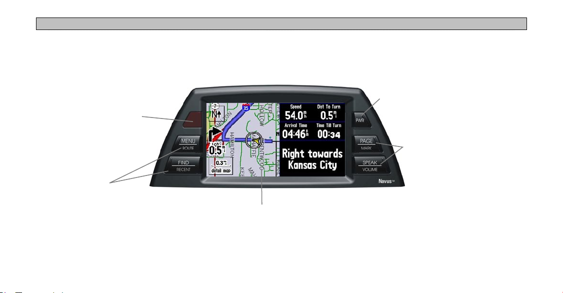
GETTING STARTED > INTRODUCING THE NAVUS
GETTING STARTED
Introducing the Navus
Infrared Window
Receives signals from the
optional remote control.
Do not block if you are
using a remote.
Feature Keys
Used to perform specific tasks
such as opening the Menu
page and finding places. See
page 6 for more information.
3
TFT Color LCD Touchscreen Display
Provides detailed, on-screen mapping
information.
Power Key
Press to turn the Navus
on or off.
Feature Keys
Used to perform specific
tasks such as opening a
page or activating the voice
announcement. See page 6
for more information.
GETTING STARTED > NAVIGATION AT A GLANCE
Navigation at a Glance
The tutorial below guides you through the steps for finding a
restaurant in your area and then creating a route to it. If you have
never used the Navus or a navigation unit before, try this simple task.
You will see that using your Navus is fast and easy!
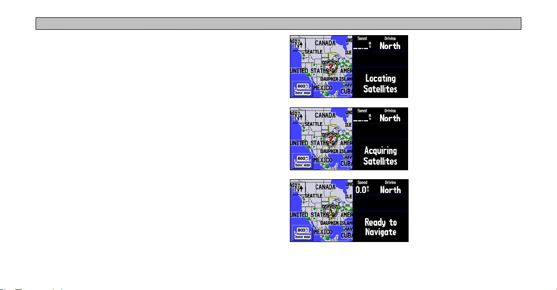
Step 1: Start up your vehicle or turn the key to the Accessory
position so that your Navus will turn on automatically. Once on,
the Navus looks for satellites. Make certain your Navus has an
unobstructed view of the sky as it looks for satellites. For example,
it cannot establish a fix if your vehicle is parked in a garage. When
your Navus has established a satellite fix, it displays a “Ready to
Navigate” message, as shown below.
4
Step 2: Press the FIND key. The Find menu appears.
Step 3: Touch Food & Drink, shown above. A list of eating
establishments near your current location appears on a page similar to
the one shown below:
Scroll bar
GETTING STARTED > NAVIGATION AT A GLANCE
Step 4: Move down the list of restaurants by tapping the down arrow
on the scroll bar. When you see a restaurant you like, touch its name.
Information about the restaurant appears on a Food/Drink page
similar to the one shown below:
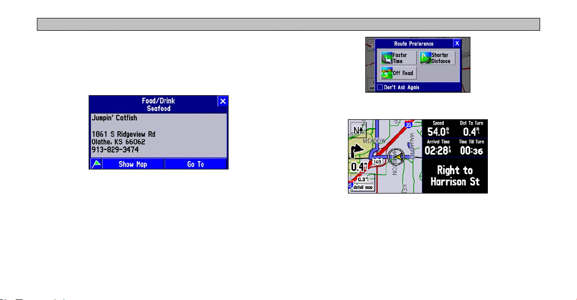
Step 6: View your route to the restaurant.
Step 5: To create a route to this restaurant, touch Go To, which is
located at the bottom of the Food/Drink page. A Route Preference
window appears. Touch Faster Time.
5
What’s Next?
The following pages introduce you to the many features available
on your Navus. In addition, this manual shows you how find a
destination, add detours or extra stops to your route, and customize
your Navus.

GETTING STARTED > NAVUS BASICS
Navus Basics
Turning the Navus On and Off
Your Navus turns on as soon as you start your vehicle or turn the key
to the ACC position. The Navus displays various screens briefly and
then the Safe Driving Warning. Read the warning and touch OK to
display the Map Information page appears. Touch OK once more or
wait until the Map page appears.
Using the Keys
Use the keys on the Navus to perform specific tasks such as finding
places and creating routes. Each key’s primary function appears in
larger text above the secondary function. Always press and release a
key to perform its primary function. Press and hold a key to activate
its secondary function (if available). For example, if you press the
MENU/ROUTE key, a Menu page appears. If you press and hold
the MENU/ROUTE key for more than two seconds, a Route page
appears.
6
PAGE/
you can view on your Navus. It also returns you to a main page if you
have previously selected an option page or window. If you want to
exit out of a current page option, press PAGE. MARK captures your
present position and saves it as a waypoint. See page 15.
MENU/ROUTE Key: MENU displays a menu of options for your
current page. It also displays sub-menu options. ROUTE displays a
menu of available route navigation features.
FIND/RECENT Key: FIND allows you to search for cities, hotels,
restaurants, addresses, and a variety of other places. RECENT allows
you to view a list of places you have recently found.
SPEAK/VOLUME Key: SPEAK triggers your Navus’s “voice” to
repeat the next turn or current destination while you are navigating a
route. VOLUME displays an adjustment slider on the page to change
the speaker volume.
MARK Key: PAGE switches between a variety of pages that
GETTING STARTED > NAVUS BASICS
Using the Touchscreen
The touchscreen on the Navus allows you to make menu selections,
position the map pointer, scroll through menu selections, and enter
data with the touch of your finger.
To use the touchscreen, touch the desired object on the screen with
your finger, applying just enough pressure to activate the function. It
is not necessary to apply excessive pressure to the touchscreen.
If you sense that the touchscreen is not responding properly, it may
need to be calibrated.
To calibrate the touchscreen:
1. Press the unit’s MENU key. Select Options.
2. Touch the
3. Press the unit’s
screen instructions.
7
Display tab.
FIND key to begin calibration. Follow the on-
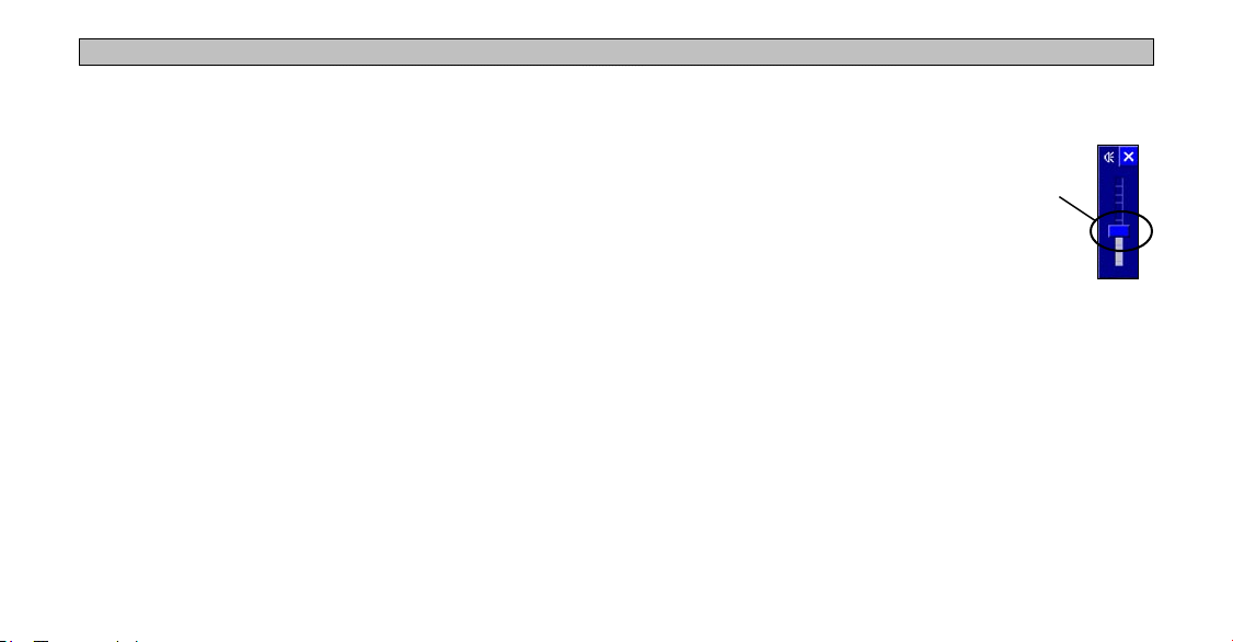
Adjusting the Speaker Volume
To adjust the speaker volume:
1. Press and hold the SPEAK/VOLUME
key. A speaker volume adjustment page
appears.
2. Adjust the speaker volume by moving
the slider up or down with your finger (on
the touchscreen). The loudest setting is
ten; the softest setting is one. Pushing
the slider all the way down turns off the speaker. (Alternatively,
volume can be cycled between three settings by repeatedly
pressing the SPEAK/VOLUME key from this screen. The three
settings are volume off, user setting, and maximum volume.)
3. When finished, touch the
X on the touchscreen.
Slider
GETTING STARTED > NAVUS BASICS
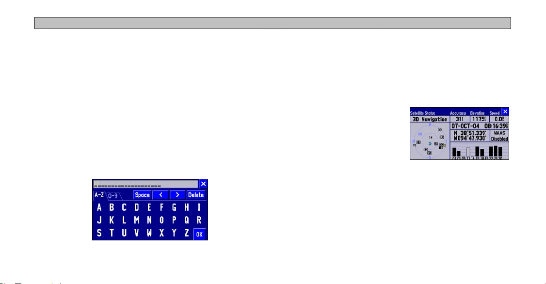
Using the On-screen Keyboard
The on-screen keyboard appears when you need to enter text for such
items as street names, locations, and waypoints. When the keyboard
Practice Using the Navus in Simulator Mode
Consider practicing the unit’s operation by using the simulator mode
prior to actual use.
appears, touch the letters to spell out a name. To use numbers, touch
the 0-9 tab and a number pad appears. The Space, <, >, and Delete
buttons function like standard word processing keys. When you have
entered all text, touch OK.
The on-screen keyboard is used in a variety of places. Its appearance
may alter, depending on your purpose for using it. On some on-screen
keyboards, letters or numbers that are not needed do not appear on
the keyboard.
To turn on Simulator Mode:
1. Make certain the unit is turned on. Press the MENU key.
2. Select the
the Main Menu page.
3. Select the
from the Information page.
4. Press the
GPS Information page.
5. Select
When you create a route, the Navus asks if you want to simulate
driving the route. Select Yes, and the Navus provides driving
instructions for the entire route. To turn on GPS navigation, repeat
the above steps and select Use Outdoors in Step 5.
8
Information icon from
GPS Information icon
MENU key from the
GPS Information page
Use Indoors.
NAVUS OPERATION
NAVUS OPERATION > LEARNING HOW TO USE THE MAP PAGE
Learning How to Use the Map Page
The Map page is one of your Navus’s main operating pages. This is
the first page to appear after the startup pages, and it provides street
detail as you navigate to a destination. The Map page contains many
features, and most are available whether you are navigating a route
or simply driving with your Navus turned on. Practice using these
features before navigating an actual route so that you can quickly
understand what you are seeing on the Map page and reduce the time
spent looking away from the road while driving.
The images to the left
show the sequence of
messages that appear
on the data tabs as the
Navus locates satellites.
The Navus might take
a little longer to locate
satellites when you turn
it on for the first time.
Viewing the Map Page for the First Time
When you turn on your Navus, you see a map image and a tab that
shows the Navus is attempting to locate satellites. Once your Navus
locates the satellites, it establishes a “fix” on your location, and you
are ready to navigate.
9
NAVUS OPERATION > LEARNING HOW TO USE THE MAP PAGE
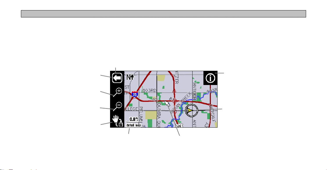
Map Page Features
The Map page contains many useful features to help you view items
on the map and navigate routes. If you are a new Navus owner,
practice using these features while your vehicle is stationary.
Map Toolbar
Show/Hide Toolbar
Zoom In
Map Toolbar
You can display a map toolbar on the left side of the map. The tools
(icons) enable you to zoom in and out of the map. To view the map
toolbar, simply touch any part of the map and the toolbar appears.
See the next page for a description of the tools.
Information
Icon
10
Zoom Out
Panning Hand/“Box” Zoom
Position Icon; shows
your current location
Map Scale Map Pointer
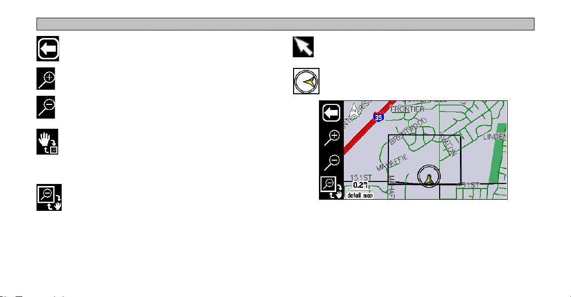
Press the white arrow to toggle between showing and
hiding the map toolbar.
NAVUS OPERATION > LEARNING HOW TO USE THE MAP PAGE
Touch the screen to move the “map pointer,” which serves
as a target marker.
Press the “+” magnifying glass to zoom in to an area and
view it with greater detail.
The “position” icon shows your current physical location
on the map.
Press the “-” magnifying glass to zoom out of an area and
view more area of the map.
Press panning hand and then user your finger to “move”
the viewing area on the map and view areas not currently
visible. This action is called “panning.” While in panning
mode, the data tabs on the right of the screen are hidden.
Press the box zoom to activate it and then draw a “box” on
the touchscreen. When you lift your finger from the screen,
the map will zoom into the selected area. Refer to the
image to the right.
11
Use your finger to draw a box on the Map page. The Navus
zooms in on the boxed-in area to show greater detail.
NAVUS OPERATION > LEARNING HOW TO USE THE MAP PAGE
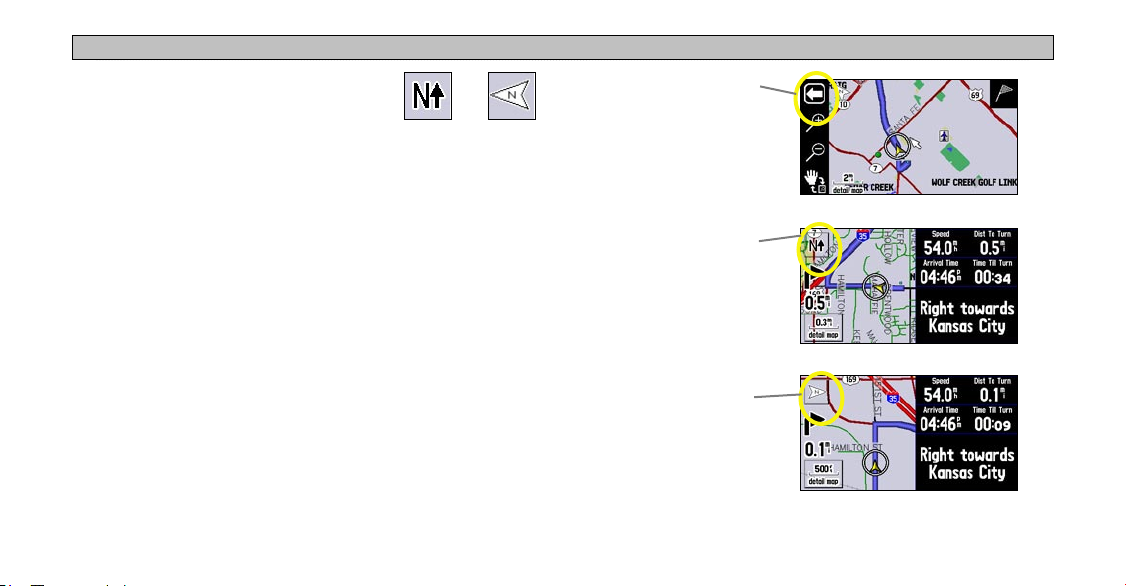
North Up and Track Up
Map orientation icons appear at the top
left side of the Map page. They show how
roads appear on your Map page. “North Up”
shows your Map page with North always at the top, as if you were
reading a paper map. As you are driving, the position icon on your
Map page moves to the left if you are going West or right if you are
going East.
With “Track Up,” your Map page shifts so that your direction of
travel always appears at the top of the Map page. If you are headed
South, the Map page shifts so that South appears at the top of the
Map page. Change the orientation from North Up to Track Up (or
vice versa) by touching the orientation icon. The map toolbar must be
hidden before you can change these icons.
12
North Up Track Up
Touch the arrow, and the
map toolbar disappears.
The middle image shows
“North Up.” Touch the N
and the direction changes
The presence of the
arrow shown at right
indicates that the map
toolbar is activated.
An orientation icon
appears.
an N with an arrow
pointing upwards, or
to “Track Up.”
Map page showing map toolbar
Map page showing “North Up”
Map page showing “Track Up”
NAVUS OPERATION > LEARNING HOW TO USE THE MAP PAGE
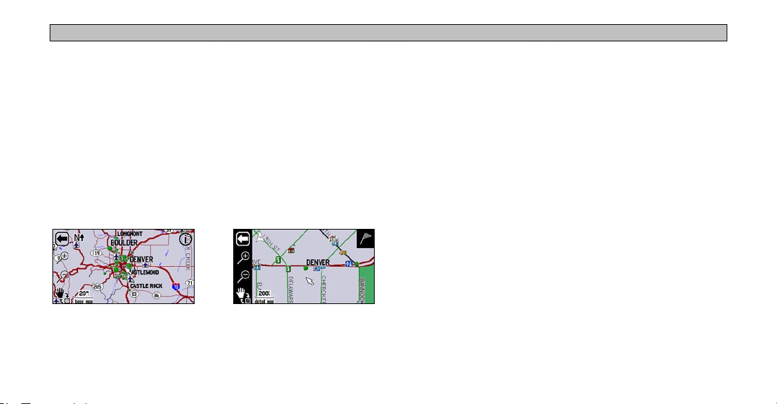
Map Scale
A map scale appears in the lower left corner of the map. It shows the
current zoom level of the map (such as 500 miles, 0.8 miles, or 200
feet) as well as what map your Navus is using. Your Navus includes a
“base map” and a “detail map.” The base map provides only general
Data Tabs
The right side of the Map page displays data tabs, which display a
variety of information about your trip, such as your speed and the
next turn or street ahead. You can quickly collapse the data tabs to
have a larger view of the map.
information such as city names and highway exits. The detail map
includes specific details such as businesses, parks, and other points
of interest. If you are viewing the map at a scale of 20 miles, your
Navus displays information from the base map. The map scale
switches from “base map” to “detail map” as you zoom in.
To show/hide all data tabs:
1. From the Map page, touch the individual tab to hide it. The tab is
replaced by a blue placeholder on the right side of the display.
2. Touch the placeholder to show the tab again. A tab turns red
when it is selected.
3. To show/hide multiple tabs, touch and hold on the left side of the
topmost group of tabs you want to hide, hold and slide your finger
in an “L” shape down and right to the side of the display. Repeat
the process in reverse to redisplay the tabs.
Detail map at 200-foot zoomBase map at 20-mile zoom
13

NAVUS OPERATION > LEARNING HOW TO USE THE MAP PAGE
Information Icon “i”
As was discussed earlier in this section, you can pan across the Map
page by touching the screen with your finger. As you pan, the map
pointer appears, which serves as a target marker. If you change the
scale, the map is redrawn with the pointer at the center. When you
place the pointer on a map object, the name of that object is displayed
and an “i” (Information) icon appears in the upper right corner.
When the i
icon appears,
touch it to view
information
about the
selected object
or location.
The panning arrow (circled) is highlighting a
point of interest.
14
In the example on the right, the
University of North Carolina at
Greensboro has been highlighted.
Touch the i icon, and a tab of
available points of interest at this
location appears. Select UNC-
Greensboro from the list, and the
information page appears.
Select the green flag icon (lower
left) if you wish to save this
location as a waypoint (see page
15 for more information).
Select Show Map to view a map,
which also displays coordinates
and the university’s distance
and bearing from your current
physical location.
NAVUS OPERATION > LEARNING HOW TO USE THE MAP PAGE
From the information page, you can also select Go To to create a
route to the university. (See page 23 for more information on the “Go
To” feature.)
To view the Map page without
the coordinates bar, press the
MENU key and select Locate on
Main Map.
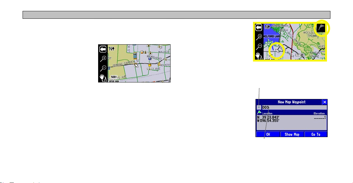
Waypoints
You can save any item on the map our find menu as a waypoint. As
these saved locations are stored in a common place, you can easily
retrieve them at a later date. You can also mark your present position
as a waypoint.
As discussed previously, an i icon appears when the map pointer
hovers over an existing map object. When the map pointer points to
an area where no map data exists, a flag icon appears in the upper
right side of the Map page.
15
To save this area as a waypoint,
touch the flag icon and a New
Map Waypoint page appears.
The coordinates for the marked
area are displayed. A default
name (number) also appears. If
you wish to name it something
else, touch the current name
(003) and an on-screen
keyboard appears, allowing you
to type in a new name. You can
also touch the icon to the left of
the name to change the icon.
To mark your current position
as a waypoint, press and hold
MARK. Then follow the
instructions above.
display a list of colorful icons to
Touch the blue square icon to
mark your waypoint.
Touch the 003 text to display
the on-screen keyboard
NAVUS OPERATION > LEARNING HOW TO USE THE MAP PAGE
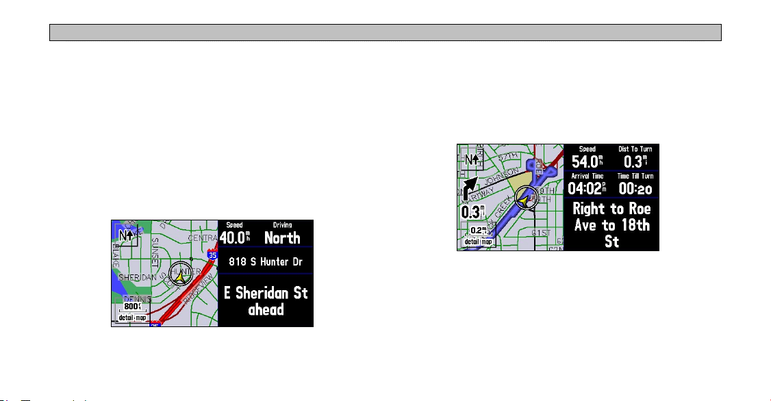
Driving and Routing Modes
While driving, the map will appear in one of two modes. “Driving”
mode appears when you have the Navus turned on but you are not
navigating a route. “Routing” mode appears when you are currently
navigating.
In routing mode, the map displays map details, your current
location, your route is marked a blue-colored route line, and driving
directions. Customizable data tabs are pre-set to display information
such as your speed, distance to the next turn, and the time remaining
before reaching the next turn.
In driving mode, the map shows map details, the map scale, and
your current location. Customizable data tabs are pre-set to show
your speed, current direction of travel, address of your current
position, and the name of the next road ahead.
Both modes display a position icon that indicates your present
position and direction of movement. Depending upon your map scale
Map Page in Driving Mode
16
setting, you can see a variety of geographic detail such as lakes,
rivers, highways, and towns.
Map Page in Routing Mode
NAVUS OPERATION > LEARNING HOW TO USE THE MAP PAGE
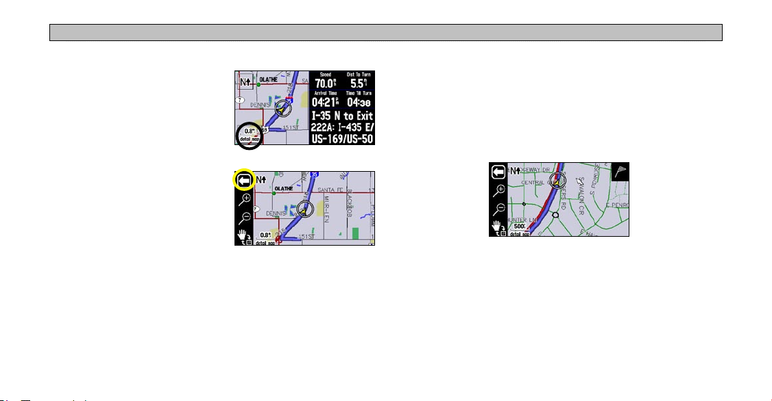
Changing the Map View While Driving
To see more detail at your current
driving position or to see a broader
view of the area, you can change the
map scale to zoom in or out on your
current position. Simply touch the
map scale.
The map toolbar appears. Use the
zoom icons (+ or - magnifying
glasses) to select your new detail
level. To close the map toolbar,
simply touch the white arrow. You
can use this feature in driving mode
and routing mode.
17
Looking Ahead on the Map Page
In the example at left, your current driving position always appears
on the map. You can also “look ahead” on the map to view areas
beyond your current position without interrupting the function of the
Map page. Touch any area on the map and drag your finger to “look
ahead” to a different area on the map.
Notice that the map pointer also appears on the map, and the map
itself stays stationary until you move (pan) the map. The position
icon continues to move along your route. To center the map on the
position icon, touch the arrow in the top left corner.

NAVUS OPERATION > NEXT TURN PAGE
Next Turn Page
As you are driving during an active route, the Map page continues to
display in routing mode until your Navus alerts you that you are near
a turn. When this happens, a Next Turn page appears. It provides a
graphic visual and gives text instructions.
An added bonus to the Navus is that the “voice” announces
upcoming turns. If you cannot safely view the screen, you can hear
the directions. The Navus announces the same instructions for an
upcoming turn three times:
18
• Immediately after you make a turn, the Navus announces the next
upcoming turn, as well as the distance to that turn.
• As you are close to approaching the upcoming turn, the Next Turn
page appears. The message is announced to alert you in case you
need to change lanes and start looking for signs in anticipation of
the upcoming turn.
• Just before the upcoming turn, the Next Turn page appears again
for that particular turn. You should be in view of the turn. The
message is announced on last time.
The Next Turn page disappears after a few seconds and then the page
that you were previously viewing reappears. If you wish to clear the
Next Turn page and return to the previous page, press PAGE. If you
wish to see the Next Turn page again, simply press SPEAK and it
reappears along with the voice announcement.
When you are not navigating a route, the Next Turn page is no longer
available.

NAVUS OPERATION > CURRENT ROUTE PAGE
Current Route Page
Another page that is visible when navigating is the Current Route
page, which provides step-by-step route instructions from start to
finish. Simply press PAGE on your Navus and the Current Route
page appears.
The numbered column shows how many miles until the next turn.
The text column explains the
upcoming driving instructions.
Estimated time enroute (time
until you reach the turn) and
Direction of turn
19
the estimated time of arrival at
the turn.
The Current Route page keeps a log of your entire route. You can
look beyond the next turn and even get an estimated idea of what
time you will reach an upcoming turn, provided you do not make
stops along the way.
You can scroll through the entire list by moving the scroll bar up or
down. Highlight and touch any of the turns on the list to view the
Next Turn page for that turn.

NAVUS OPERATION > TRIP INFORMATION PAGE
Trip Information Page
If you are making a long trip, you may find the Trip Information page
To reset the trip information or the maximum speed:
1. From the Trip Information page, press the MENU key. You can
to be very useful. It indicates your current speed and many helpful
statistics about your trip. To open the Trip Information page, press
PAGE. See page 22 for a list of the information displayed on the Trip
2. From the Menu page, select Reset Trip to reset the Trip
Information page.
3. Select Yes at the verification page to complete the reset.
Be certain to reset the Trip Information page before beginning a trip.
20
also select the blue square buttons to the right of the main
odometer or Max Speed (in which case you can skip to step 3).
Computer or Reset Max Spd to reset the Maximum Speed.

NAVUS OPERATION > TRIP INFORMATION PAGE
To select a Mileage Log:
1. Select the Job 1 (or None) field on the Trip Information page. A
box containing various log names (Job 1, Job 2, Job 3, Other,
None) appears.
2. Select the desired
this log.
Mileage Log name. All mileage is recorded in
To rename a Mileage Log:
1. Make certain the desired Mileage Log name is displayed. Then,
press the unit’s
2. Select
3. Enter the new name by using the on-screen keyboard that
Rename Log.
appears.
MENU key to display a Menu page.
To reset a Mileage Log:
1. Make certain the desired Mileage Log name is displayed. Then,
press the unit’s MENU key to display a Menu page. You can also
select the blue square button to the right of the Mileage log.
2. Select
21
Reset Log and select Yes at the verification page to
complete the reset.

NAVUS OPERATION > TRIP INFORMATION PAGE
Data Displayed on the Trip Information Page
The following information is displayed on the Trip Information page:
Time of Day: Shows the current time on the top left side of the page.
Compass Ribbon: Shows your current compass heading while
moving with a red indicator arrow.
Speed: The current vehicle speed, displayed in miles or kilometers
per hour.
Odometer: A running total of distance traveled since the Trip
Computer was last reset.
Mileage Log: Allows you to use up to four different mileage
odometers for recording trip distances. You can also rename each
mileage log (see the previous page).
22
Driving Avg: Your average speed of travel during the time the
vehicle has been in motion since the Trip Computer was last reset.
Overall Avg: Your average speed of travel (including time stopped)
during the time the Navus has been tracking your location since the
Trip Computer was last reset.
Max Speed: The maximum speed recorded since the Trip Computer
was last reset. Max Speed can also be reset individually without
resetting other Trip Computer information.
Driving Time: The length of time that the vehicle has been in motion
since the Trip Computer was last reset.
Stopped Time: The length of time that the vehicle has been stopped
(or stationary) during the time the Navus has been tracking your
location since the Trip Computer was last reset.
Total Time: The total length of time that the Navus has been tracking
your location since the Trip Computer was last reset. This is always
equal to Driving Time plus Stopped Time.

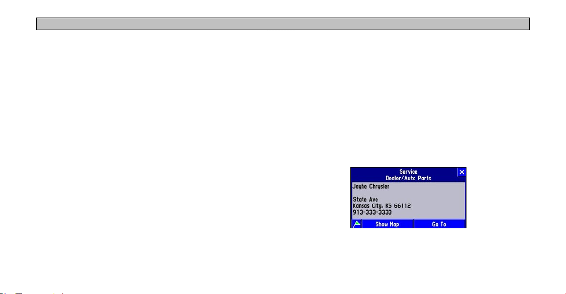
FINDING PLACES AND ROUTING TO THEM > FINDING PLACES TO VISIT
FINDING PLACES AND ROUTING TO THEM
Finding Places to Visit
Your Navus includes thousands of businesses and attractions that
are provided by the mapping software. To view a complete list of
places that are near you, select All Points of Interest from the Find
menu. If you want a more specific list, select from the additional
options located on the Find menu: Food & Drink, Lodging, Services,
Entertainment, Attractions, Shopping, Transportation, and Emergency
& Government. You can also search for Chrysler Dealers.
To find a place and route to it:
your current location (Near Here)
appears.
3. Select the place you wish to visit.
An information page appears.
4. Select Go To
page. A Route Preference
window appears.
5. Select Faster Time
Distance, or Off Road (see the
following page).
on the information
, Shorter
A route calculation icon appears in
the lower left corner of the Map
page as the unit calculates the route.
1. Press the FIND key. The Find
menu appears.
2. Select an option that will help
you find your destination such
as Food & Drink or Chrysler
Dealers. A list of places near
23
When the route is calculated, a
voice prompt sounds and a blue
route line appears. The Navus is
now ready to navigate the route.

FINDING PLACES AND ROUTING TO THEM > FINDING PLACES TO VISIT
Route Preference Window
Each time you create a route, the Navus asks you your route
preference using the Route Preference window.
Faster Time: Choose this option if
you want the Navus to use time as
the criteria to calculate the route. The
driving time will be shorter but the
distance might be longer.
Shorter Distance: Choose this option if you want your Navus to use
distance as the criteria for calculating your route. The distance might
be shorter but the route may take more time to navigate.
Off Road: Choose this option to view a direct-line route to your
destination. This option does not provide a turn-by-turn route. It
merely displays a straight line from your end point to your start
point; the voice guidance tells you the direction and distance to your
destination. Use this option if you are travelling on obscure roads or
off-road.
24
Other Ways to Find Places
When you are in driving mode, the Navus finds places that are near
your current physical location (Near Here). Here are other options:
Near Current Route: Lists places
along your entire route. This option
is available when you search for a
place during an active route. Near
Current Route finds and lists places
that are within a 1/2 mile search area
of any point on your route.
If your search does not reveal very many places because you are in
a sparsely-populated area, consider widening the search area along
your route. From the list of places that appeared under the Near
Current Route tab, press the unit’s MENU key. From the Menu page
that appears, select Search Within. You can then elect to expand
your search up to 1, 2, 5, or 15 miles along your current route. A new
list appears.
FINDING PLACES AND ROUTING TO THEM > FINDING PLACES TO VISIT
Near [Destination]: Use Near [Destination] to find places that
are located at the end of your active route. For example, if you are
travelling to Phoenix, the Near Phoenix tab returns places that are
within the vicinity of Phoenix.
Near Map Pointer: Use Near Map Pointer to find places that are
near the area where you have placed the map pointer while panning.
By Name: Use By Name to spell out the name of the place you are
searching for with the on-screen keyboard. Note that when you use
By Name, all regions loaded in your mapping software are searched.
Near Other: Use Near Other to find a place that is not in your
immediate location. For example, if you are physically in Kansas and
you want to find a hotel in Colorado, select Near Other, and a map
of the U.S. appears. Touch an area in Colorado that is close to the
area where you wish to find a hotel, and then touch the check mark
that appears in the upper right corner of your Map page. A new list of
hotels in this area of Colorado appears.
25
Filtering Results
To reduce the number of results in a search, use the Filter tab to type
in the entire name or part of the name of the place you seek.
When you find the place you are searching for, touch the name, and
the place’s address and telephone number appear. Touch the green
flag in the lower left side of the window if you want to mark the place
as a waypoint. Touch Show Map if you want to see it on the map.
Touch Go To if you want to navigate to the place you found.

FINDING PLACES AND ROUTING TO THEM > FINDING ADDRESSES OR INTERSECTIONS
Finding Addresses or Intersections
5. Select
Select Street Address or Street Intersection from the Find menu.
In both case a page appears that allows you to enter pertinent street
information.
6. Select
Tip: If you do not want to type the city or zip code using the on-
To find an address or intersection and route to it:
1. Press the FIND key. The Find menu appears.
2. Select Street Address. A Find Address page appears.
3. Touch the Limit To
wish to limit your search to
an option other than the state
where the Navus is currently
located, or the state where
the map pointer is currently
located.
4. Select Enter a City, type the name of the city using the on-screen
keyboard.
26
box if you
7. Touch the
8. Touch the
Enter a State/Province and select your desired state or
province from the list that appears.
Postal Code to type the zip code.
screen keyboard, touch OK (in the lower right of the keyboard)
and a list of all preinstalled cities and zip codes appears.
Number box and type the number portion of the
address using the on-screen keyboard. Leave this box blank if
necessary. Touch
screen keyboard. Do not enter directional words such as West or
street types such as Avenue. Touch OK when finished. From the
list of names that appears, select your street. A completed Find
Address page appears.
OK when finished.
Street box and type the street name using the on-

FINDING PLACES AND ROUTING TO THEM > FINDING ADDRESSES OR INTERSECTIONS
9. Touch Find. A Select Address
page appears. Scroll down
the list and select your
address. An Address page
appears.
10. Touch Go To
calculates the route. Select an option from the Route Preference
window, if necessary. See page 24 for more information.
and the Navus
When you find the address or intersection you are searching for,
an information page appears. Touch the green flag in the lower left
corner of the page if you want to mark the address or intersection as a
Refining Your Search
Always try to narrow your search as much as possible to return fewer
results. Entering the city name or zip code significantly narrows
your list.
If your search returns too many addresses, touch the X in the top
right corner of the Select Address page to return to the Find Address
page. Press the MENU key and select Refine Street. Enter additional
information in the boxes provided and then select OK. A new Find
Address page appears. Touch Find, and select your address from the
list of names that appears.
waypoint. Touch Show Map if you want to see it on the Map page.
27

FINDING PLACES AND ROUTING TO THEM > FINDING CITIES AND EXITS
Finding Cities
Select City Center from the Find menu to locate cities.
To find a city and route to it:
1. Press the FIND key on your Navus. The Find menu appears.
2. Select
3. Select the desired city. An information page about that city
4. Touch Go To
When you find the city you are searching for, an information page
appears. Touch the green flag in the lower left corner of the page if
you want to mark the city as a waypoint. Touch Show Map if you
want to see it on the Map page.
28
City Center. A list of cities near your current location
appears.
appears.
from the information page and the Navus calculates
a route to that city. Select an option from the Route Preference
window, if necessary. See page
50 for more information.
Finding Exits
Select Exit from the Find menu to search for highways, freeways,
and interstates throughout the U.S. This information is useful if you
are travelling and need to stop at an exit with a service station or
when you need to find the nearest rest area.
To find an exit and route to it:
1. Press the FIND key on your Navus. The Find menu appears.
2. Select
3. Select the exit you are looking for. Information about that exit
4. Touch the name of the service to display an information page.
5. Touch Go To
Exit. A list of exits near your current location appears.
appears, including a list of services that are located at that exit.
Press X to go back to the main exit information page.
from the information page and the Navus calculates
a route to that city. Select an option from the Route Preference
window, if necessary. See page
24 for more information.

FINDING PLACES AND ROUTING TO THEM > FINDING WAYPOINTS
Other Ways to Find Exits
• You can refine your search by touching the down arrow (▼)
on the All Exits tab to view only a list of Exits with Services,
Rest Areas, or Other Exits such as weigh stations and Welcome
Finding Waypoints
You can search for waypoints that you have created and stored in
your Navus by selecting Waypoints from the Find menu. See page
15 for more information on creating waypoints.
centers.
• If you want to see what exits are available on upcoming highways
or intersections, touch the down arrow (▼) on the On [Current
Interstate/Hwy] tab and touch Change Highway. Then, spell out
the name of the interstate or highway you are searching for.
29
To find a waypoint and route to it:
1. Press the FIND key on your Navus. The Find menu appears.
2. Select Waypoints. A list of waypoints near your current location
appears.
3. Select the waypoint you are looking for. A Waypoint Review page
appears.
4. Touch Go To from the Waypoint Review page and the Navus
calculates a route to it. Select an option from the Route
Preference window, if necessary. See page 24 for more
information.

FINDING PLACES AND ROUTING TO THEM > FINDING “RECENT FINDS”
Finding “Recent Finds”
Your Navus keeps track of the places you find and stores the 30
most recent finds in memory. The Navus only stores places that you
actually view. Suppose you do a search for restaurants and five names
appear. If you view information on two of them, then these two
restaurants are stored in your Recent Finds list.
To find a recent find and route to it:
1. Press the FIND key on your Navus. The Find menu appears.
2. Select
3. Select the
4. Touch Go To
30
Recent Finds. A list of recent finds near your current
location appears.
Recent Find you are searching for. An information
page appears.
from the information page and the Navus calculates
a route to it. Select an option from the Route Preference window,
if necessary. See page
24 for more information.
Other Ways to find “Recent Finds”
To refine your search, touch the All tab and narrow your search by
selecting Points of Interest, Addresses & Intersections, or Other.
Deleting Recent Finds
You can manage the amount of items in your Recent Finds list by
deleting the ones you no longer want.
To delete a recent find:
1. From the Recent Finds list, select the item you wish to remove.
An information page appears.
2. Touch
3. To delete the list or delete all points, press
Note: Deleting information from the Recent Finds list does not delete the
actual city from your detail map, nor does it remove waypoints you created.
Remove and then select Yes at the verification window.
MENU and select
Delete List or Delete All Finds.

FINDING PLACES AND ROUTING TO THEM > PLANNING A TRIP USING FIND FEATURES
Planning a Trip Using Find Features
As you have discovered while reading this section, you can search for
places by using a variety of “find” methods. If you are planning a trip
and would like to find lodging, restaurants, and other places ahead of
time, consider using the “chain find” method below. Do NOT follow
these instructions while driving.
1. Find the city you plan to visit. For example, we chose Fraser, CO.
2. While still on the information page for Fraser, press the
and select Lodging to look for a place to stay in Fraser. In our
example, we chose Karen’s Bed & Breakfast.
3. From the information page for Karen’s Bed & Breakfast
the FIND key and select Food & Drink to look for a place to eat
near your lodging selection.
You can also find entertainment, services, and other places near your
chosen lodging area in the city of your choice. When you are ready to
take your trip, simply find these places in your Recent Finds list. You
can also save places you find as waypoints. See page 15.
31
FIND key
, press

PLANNING AND MODIFYING ROUTES > PLANNING A ROUTE
PLANNING AND MODIFYING ROUTES
The quickest way to navigate to a place using your Navus is to find
your destination using the FIND key and route to it. But if you want
to plan trips where your starting location is not your current physical
location, use the Route feature. Once you plan, create, and save the
route, you can retrieve it when you need it and you will not have to
stop and ask for directions.
The Route Menu lists many options for creating routes. To access the
menu, press and hold the MENU/ROUTE key on your Navus for
two seconds. You can also press MENU, then select Route.
32
Planning a Route
Planning routes is fast and easy once you become familiar with and
understand the various steps and options.
To plan a new route:
1. Press and hold the MENU key. A Route Menu page appears.
2. From the Route Menu page, select
appears.
3. From the Start Point window, select one of the three options:
Current Location, Use Map, or Find. Then select the start point.
4. Once you select an option, the Start Point window disappears
and an End Point window appears. Repeat the previous step.
5. The End Point window disappears and a Route Preference
window appears. Select one of the three options.
A route calculation icon appears in the lower left corner
of the Map page as the unit calculates the route. A voice
prompt sounds and a blue route line appears. The unit is
now ready to navigate the new route.
New. A Start Point window

PLANNING AND MODIFYING ROUTES > PLANNING A ROUTE
As soon as your route is created, your Navus begins to navigate the
route. If at any time you wish to stop a route, select Stop Route from
the Route menu. To resume the route, select Resume Route.
Saving a Route
Your Navus always remembers the last route you created. You can
save a route either while you are navigating it or after you have
navigated the route.
To save a route:
1. Press and hold the MENU key. A Route menu appears.
2. Select
33
Save. A Route Saved window appears. It includes the
name of your current/completed route.
3. If necessary, change the name of the route to something more
meaningful to you by touching the route’s current name. Enter the
new name using the on-screen keyboard that appears.
4. Touch
OK to save the route.
Your Navus can hold up to 50
saved routes. To select a saved,
select Route List from the Route
menu. A list of your saved routes
appears. Touch the name of your
desired route. A new page appears
which allows you to rename,
delete, or activate the route. You can also advance to the next route or
move back to your previous route on the route list.

PLANNING AND MODIFYING ROUTES > PLANNING A ROUTE
Deleting or Renaming a Saved Route
You can delete a single route or all of the saved routes that exist in
your Navus. You can also rename a saved route.
To delete or rename a single route:
1. Press MENU and select Route.
2. Select
3. Select Rename to personalize the route name (if necessary) by
4. Select
5. Select
34
Route List and highlight the intended route. Information
about that route appears.
using the on-screen keyboard.
Delete to remove the route from your Route List.
Activate to navigate this route.
To delete all routes:
1. Press MENU and select Route.
2. Select
3. When the Route List is displayed, press
4. Sel
Route List.
MENU.
ect Delete All to delete all routes in your Route List.

PLANNING AND MODIFYING ROUTES > MODIFYING A ROUTE
Modifying a Route
After you have practiced creating and saving simple routes, you are
ready to learn how to modify them to suit more specific needs.
Recalculating a Route
If you decide to temporarily part from your current route, you
can select Recalculate from the Route menu to calculate a new
route from your current location to your destination. The Navus
recalculates and updates your route.
Adding a Detour
While you are navigating a route,
you might come to a roadblock
or other obstruction and want to
detour from your current route.
If this happens, simply select
Detour from the Route menu. A
Detour Distance window appears.
35
You can alter your route for either 1/2, 1, 2, 5, or 15 miles. If you are
in New York City, for example, and you see that the next few blocks
are unusually congested with traffic, you might want to opt for a
1/2-mile detour.
Once you select a distance, your Navus calculates a new route and
provides you with new instructions. On some routes, the route you
are currently taking might be the only reasonable option. In this
case, you will not be able to take a detour. Also, your Navus makes
every possible attempt to get you back on the original route at your
requested distance; however, the distance may be longer if no other
roads exist that can get you back to the original route.
Your Navus remembers detours you set until you stop the current
navigation or until you turn off the unit.
To cancel the detour, select Detour from the Route menu. Then select
Cancel Detour.

PLANNING AND MODIFYING ROUTES > MODIFYING A ROUTE
Adding Extra Stops (Trip Itinerary)
3. Select an option from the Add
You can add up to 250 extra stops on your way to a final destination
via the Trip Itinerary feature. When you have entered all of the stops,
your Navus can arrange them in the most efficient order (“auto
arrange”) so that you can visit each stop without extra driving.
You can add extra stops to an active route that you have previously
4. Select
saved (which you can retrieve and activate from the Route List), or
one that you have just created.
5. Select
To add an extra stop to the active route:
1. Press and hold the MENU key
for two seconds to view the
Active Route menu. Select Trip
Itinerary. The Trip Itinerary page
listing your current destination
appears.
2. Select
36
Add Extra Stop. An Add Extra Stop page appears with
two options for finding your location: Use Map or Find.
6. To add more extra stops, select Add Another from the Trip
Extra Stop page. For more help
on using these options, see
“Finding Places and Routing
to Them” beginning on page 23. When you have entered the
desired location, an information page about this location appears.
Add Stop. The new stop is added to the Trip Itinerary
page.
Done on the Trip Itinerary
page. Your original route is
automatically recalculated to
include the newly added point.
(Note: If you touch the X in the
top right corner of the Trip Itinerary page, your Navus removes
the newly-created extra stops and uses the original route.)
Itinerary page and repeat steps 3–5 above.

PLANNING AND MODIFYING ROUTES > MODIFYING A ROUTE
Arranging Extra Stops
3. Select the stop you want to move and press the
If you add more than one extra stop, you may want to arrange the
order of the stops on the route to minimize route length.
4. Select
arrow to change the order of the stop in the route. Repeat until
the stops are in the desired order.
Done when finished.
Up or Down
To create a route through all extra stops that is optimized for
distance, simply select Auto Arrange from the Trip Itinerary page.
A window appears that asks if you also want your destination point
to be reordered. Answer Yes, and the unit arranges all of your stops,
including the destination point. Answer No, and the unit arranges all
If you have a definite order for the places you would like to visit, you
of your stops EXCEPT the destination point.
can arrange the order by highlighting an extra stop and moving it up
or down by using the up/down arrows on the Trip Itinerary page.
Deleting Extra Stops
If you want to remove one of your extra stops from your route,
To arrange your stops:
1. Press and hold the MENU key for two seconds to view the
Active Route menu. Select Trip Itinerary. The Trip Itinerary page
appears.
2. Select the
37
arrow icon.
simply touch that stop to display its information page. Select Remove
and select Yes to verify. The extra stop is removed from your route.
PLANNING AND MODIFYING ROUTES > MODIFYING A ROUTE
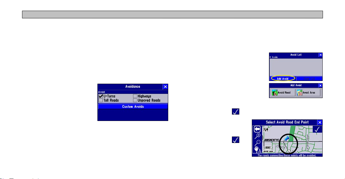
Adding Avoidances
You can add areas and certain road types you want avoid on your
route. For example, if you encounter roads that are highly congested,
you can add that area to your Avoid List.
To add an avoidance to your route:
1. Press and hold the MENU key for two seconds to view the Active
Route menu. Select Routing Setup. The Routing tab opens.
2. Select Avoidance. The
Avoidance page appears.
3. Select the road type you want
to avoid. The Navus avoids all
roads types that have a check
mark in the Avoid box.
38
To avoid a road:
1. Press and hold the MENU key for two seconds to view the Active
Route menu. Select Routing Setup. The Routing tab opens.
2. Select Avoidance. The Avoidance page appears.
3. Select Custom Avoids. The
Avoid List page opens. To add an
avoidance, select Add Avoid.
4. Select Avoid Road
to avoid on your routes. A map
appears, enabling you to mark a “start
point” on a road.
5. Touch the beginning point of the road you want to avoid and
touch the check mark in the right corner. A blue push pin
marks the start point.
6. Touch the end of the road
area you want to avoid and
touch the check mark .
to select a street

PLANNING AND MODIFYING ROUTES > MODIFYING A ROUTE
A map of the avoided road
appears with a default name (the
street names). You can change
this name by touching it and
entering a new name using the
on-screen keyboard.
6. Touch the second corner of
the area you want to avoid.
A gray box covers the area
you have selected. Touch the
check mark to accept the
area.
A map of the avoided road
To avoid an area:
1. Press and hold the MENU key for two seconds to view the Active
Route menu. Select Routing Setup. The Routing tab opens.
2. Select Avoidance. The Avoidance page appears.
3. Select Custom Avoids. The Avoid List page opens. To add an
avoidance, select Add Avoid.
4. Select Avoid Area
routes. A Map page appears, enabling you to mark a “start point.”
5. Touch the first corner of the area you want to avoid and touch
the check mark in the right corner. A blue push pin marks the
start point.
39
to select a rectangular area to avoid on your
appears with a default name
(Area 000). You can change this
name by touching it and entering
a new name using the on-screen
keyboard.
Once entered, your Navus avoids
these roads/areas unless no other
roads are available. The Navus
will avoid these area until you
remove them from the Avoid List
or uncheck them.

PLANNING AND MODIFYING ROUTES > SETTING A HOME WAYPOINT
Setting a HOME Waypoint
Your Navus includes a special feature that allows you to set a HOME
waypoint, which can be your home, office, or any other place to
which you return most often. Once set, you can opt to go “HOME.”
For example, if you are driving in a new city or down an unknown
street and you want to easily find your way home, simply press the
FIND key two times. A window asking you to verify that you want to
route home appears. Select Yes, and your Navus directs you to your
HOME waypoint.
40
To set a HOME waypoint:
1. Press and hold the MENU key. A Route Menu page appears. (As
an alternative, simply press the FIND key two times. Then, go to
Step 3 below.)
2. From the Route Menu page, select Set HOME Waypoint. A Set
HOME Waypoint page appears.
3. Select one of the three options:
Find.
4. Once you select an option, find your HOME location using this
option. Then touch
5. From the New Waypoint page, touch
set.
Current Location, Use Map, and
OK. A New Waypoint page appears.
OK. Your Home waypoint is

PLANNING AND MODIFYING ROUTES > SETTING A HOME WAYPOINT
Changing Your HOME Waypoint
If you travel frequently, you may want to change your HOME
waypoint to a new location, such as a hotel or your meeting place, so
you can find your was in unfamiliar surroundings.
To change your HOME waypoint:
To route HOME:
1. Press the FIND key two times.
2. Select Yes
Your Navus creates a route to your HOME waypoint.
41
from the window that appears.
1. Press FIND and select Waypoints.
2. Find your HOME waypoint and touch it. Then touch
Select Yes to confirm.
3. Follow the instructions on the previous page to reset your HOME
waypoint.
Delete.

CUSTOMIZING YOUR NAVUS > CUSTOMIZING THE MAP PAGE
CUSTOMIZING YOUR NAVUS
If you’ve experimented with creating routes and finding places using
your Navus, you may feel you’re ready to customize it to enhance
your navigational needs. Take a moment to look at the options in this
section and decide which features you’d like to customize.
To customize many features of your Navus, press the MENU key.
The menu below appears.
Note: Your Navus’s factory settings (or default settings) do not need to be
changed in order for your unit to function completely. If you do not like the
settings, you can change some or all of them. See the page 48 for instructions
on resetting the Navus to default settings.
42
Customizing the Map Page
You can customize the way information appears on the Map page.
For example, you can change the color of the Map page, show
more or less detail on the Map page, or even prevent items such as
railroads from appearing on the Map page.
To customize the Map page:
1. Press MENU and select Map Setup.
2. Touch each tab and make changes as necessary.
3. Touch the
X when you are finished.
Map Setup page

CUSTOMIZING YOUR NAVUS > CUSTOMIZING THE MAP PAGE
Map Tab
Map Detail: Adjusts the amount of detail that is displayed on your
Map page. Most shows maximum detail and Least shows minimum
detail. A higher detail level causes the map to redraw slowly. For
everyday use, keep the view level set to Normal.
Orientation: Selecting North Up displays the map with North at the
top. Selecting Track Up automatically rotates the map to keep your
current direction of travel at the top of the page. See page 12 for more
information.
Color Mode: Select between Day, Night, or Automatic for best
viewing conditions. Day shows a mostly yellow background. Night
shows a black background, which provides easier viewing while
driving at night. Auto allows your Navus to automatically switch
between the two at sunrise and sunset.
43
AutoZoom: When On, the Map page zooms in and out as you travel.
As you approach a turn, the Map page progressively zooms in. After
the turn is completed, it zooms out to show you the entire route.
Line, Point, City, and Area Tabs
Line tab: Controls how the track log, railroads, and street labels
appear on the Map page. By default, railroad names are not displayed
on the map.
Point tab: Controls how waypoints, exits, and POIs (points of
interest) appear on the map.
City tab: Controls how cities of various sizes appear on the map.
Area tab: Controls how rivers, lakes, parks, and other areas such as
airports, shopping malls, and hospitals appear on the map.

CUSTOMIZING YOUR NAVUS > CUSTOMIZING THE MAP PAGE
The Line, Point City, and Area Tabs contain two common settings:
Text Size and Max Zoom:
Text Size: Specifies how large or small the names of items on
your Map page appear. If you do not want the name of an item to
appear on the Map page, select Off in the Text Size field.
Resetting Map Setup Default Settings
You may reset (restore) map settings for each individual setup tab, or
you can reset map settings for all five tabs at once.
To reset the map setup default settings:
1. While on the Map Setup page, select the tab (Map, Line, Point,
Max Zoom: Specifies the maximum map scale at which a map
item displays. If Auto is selected, the maximum map scale is
determined by the Map Detail setting on the Map tab (see page
43) to prevent the map from becoming too cluttered. If Off is
2. Press the
3. To restore the settings for the
selected, the item does not display.
Some map data is only visible at certain zoom scale ranges. For
To restore the settings for all
example, you may set Street Label (from the Line tab) to a Max
Zoom of 200 miles, but the street names would not show above a 0.8
mile zoom scale. Setting the Max Zoom to Auto generally gives the
best display performance.
44
etc.) you wish to restore to the original settings.
MENU key. A reset menu appears.
current tab selection, select
Reset Settings.
tabs on the Map Setup page,
select Reset All Settings.

CUSTOMIZING YOUR NAVUS > CHANGING THE DATA TABS
Changing the Data Tabs
As you have discovered while using your Navus, the data tabs on
the Map page display offer a variety of useful information. You can
customize what type of information appears in each data tab, and you
can change the color of the data fields. You can even hide the data
tabs if you do not want them to appear while you are driving.
Your Navus includes three tab styles that contain pre-set information.
You can choose from one of these three tab styles, or you can create
your own customized tab style.
To change the information that appears in the data tabs, press MENU
Information displayed while you are just driving
45
to access the Menu page. Then, select Tab Setup. A Tab Setup page
that displays both a Mapping and a Routing tab appears. Follow the
instructions on the next page.
Information displayed while you are routing

CUSTOMIZING YOUR NAVUS > CHANGING THE DATA TABS
To choose from one of the three pre-set data tabs:
1. From the Tab Setup page,
select either the Mapping (for
when you are just driving) or
Routing (for when you are
following a route) tab.
2. Select the Tab Style
down box to reveal a list of
styles: Wide Tabs, Narrow
Tabs
, or Compact Tabs.
3. Choose a style. A preview of the layout and type of data appears
on the right side of the page. Select a style for the Mapping tab,
and then for the Routing tab.
46
drop-
The Tab Setup page features three
pre-set tab styles.
To create your own customized data tabs:
1. From the Tab Setup page, select the Mapping or Routing tab.
2. Press the
3. From the Menu page, select
4. Select the tab button you wish to customize (Tab 1
5. Select the name of data you
MENU key on the unit. The Menu page appears.
Custom Setup.
, Tab 2…).
A Select Information list
appears, which includes the
data you can include in a tab.
wish to display. A Select
Tab page appears. It shows
a variety of tab sizes (if
available) from which to
select as well as other data
types that can be displayed
(if possible) with the data type
you selected.

CUSTOMIZING YOUR NAVUS > CHANGING THE DATA TABS
6. Select Prev (Previous ) or
Next to cycle through the
available tab types.
7. When the desired tab
appears, select OK. When
you have selected types for
all tabs, touch the X in the
upper right corner.
47
To change the data tab color:
From the Tab Setup page, select the color box to display a list of
optional tab colors. The
same shade.
Mapping and Routing tabs must be the
To restore the original tab settings:
The Wide Tabs setting for both the Mapping and Routing tabs
contain the original tab settings. If you wish to review the original
tab settings, select Wide Tabs for both.

CUSTOMIZING YOUR NAVUS > CUSTOMIZING THE OVERALL SETUP
Customizing the Overall Setup
Your Navus allows you to customize the unit’s overall system. Even
though your unit is designed to perform well without changing any
of these settings, feel free to customize as you become more familiar
with your Navus.
Customize the overall setup by pressing the MENU key. From the
Menu page that appears, select Options. An Options page appears
with a number of tabs. The settings on each tab are described in the
following pages of this manual.
Select any tab by touching the
desired tab’s name (such as
General or Guidance). To change
Restoring your Navus’s Original Settings
At some point, you may want to restore the default settings for one
or more tabs on the Options menu. Note that you can only restore the
original settings one tab at a time (such as all settings for the Time
tab or all settings for the Routing tab).
To restore the original settings:
1. From the Options page, select the desired tab you wish to restore
to the original settings by touching the tab name.
2. Press the unit’s
3. Select
are restored.
4. Repeat steps 1-3 to restore original settings to other tabs.
a setting within each tab, simply
touch the down arrow associated
with that setting. A drop-down
box of options appears. Touch the
option you desire
48
MENU key. A Menu page appears.
Reset Settings. The original settings for that particular tab

CUSTOMIZING YOUR NAVUS > CUSTOMIZING THE OVERALL SETUP
General Tab
Units: Allows you to measure distance in miles (Statute) or
kilometers (Metric). If you select Statute, speed is shown in miles
per hour and elevation is shown in feet. Metric shows speed in
kilometers per hour and elevation in meters. Note: If you change
your Data Tabs (page 45) to show Elevation, Feet or Elevation,
Meter, these settings still appear despite your Units setting.
Voice: This setting determines when the Navus “speaks.”
Guidance and Status: The unit speaks guidance and status
messages during route navigation. Guidance messages include
such route navigation
messages as “drive point eight
miles west, then turn right.”
Status messages include
phrases such as “lost satellite
reception.”
49
Route Guidance: The unit speaks guidance messages during
route navigation, as described above. It does not give status
messages.
SPEAK Key Only: The unit only speaks when the SPEAK key is
pressed (it does not talk otherwise).
Attention Tone: Determines whether the voice prompts are preceded
by a chime. This is turned on by default.
Power-Off Clock: In some vehicles, a clock appears on the Navus
screen when you turn off the unit. If you do not want the clock to
appear, set this to Off.
Touchscreen Tone: Allows you to turn the touchscreen click sounds
On or Off.
Keypress Tone: Allows you to turn the keypress beeper sounds On
or Off. A beep confirms that a key (such as MENU, FIND, SPEAK)
on the unit has been pressed.

CUSTOMIZING YOUR NAVUS > CUSTOMIZING THE OVERALL SETUP
Guidance Tab
Off-Route Recalculation: Controls how the Navus recalculates the
route when you depart from its original instructions.
Prompted: You are asked if you want the unit to recalculate the
route.
Automatic - Announced: The unit automatically recalculates and
announce to the user it is recalculating.
Automatic - Silent: The unit automatically recalculates the route,
but it does not announce to the user it is recalculating.
Off: The unit does not recalculate when you go off route.
Next Turn Pop-Up: Controls when the Next Turn page is displayed.
Recall that the Next Turn page only appears during an active (or
simulated) route as you are approaching a turn.
Off: The Next Turn page never appears.
SPEAK Key Only: The Next Turn page appears when you press
the SPEAK key.
50
Automatic Only: The Next Turn page automatically appears as
Both: The Next Turn page automatically appears as you approach
Routing Tab
Route Preference: Determines which criteria are used for calculating
your route. The following options are available:
Faster Time: Time is used as the criterion for calculating your
Shorter Distance: Distance is used as the criterion for calculating
Off Road: A direct line from your current physical location to
you approach a turn.
a turn, and if you wish to hear the instructions again, press the
unit’s SPEAK key.
route. Routes calculated with this setting are faster to drive but
may be longer in distance.
your route. Routes calculated with this setting are shorter in
distance but may take more time to drive.
your destination is displayed. This may be useful when you are

CUSTOMIZING YOUR NAVUS > CUSTOMIZING THE OVERALL SETUP
travelling outside of detailed map coverage areas, or where no
roads exist.
Custom: Route calculations are based on the settings you create
on the Custom Road Preferences page. Select the Custom Roads
Prefs button on the Routing tab. For information on customizing
this page, see page 52.
Ask Me My Preference
: Determines whether you are asked to select
a Route Preference (Faster Time, Shorter Distance, Off Road, or
Custom) before the unit calculates routes.
Better Route: This generates an even better quality route, but
uses a longer calculation time than the Quick Calculation method.
Best Route: This generates the most optimal route, but takes the
longest time to calculate.
Calculate Routes for: Lets you take full advantage of the routing
information built into the Navus’s mapping software. Some roads
have vehicle-based restrictions. For example, a street or gate may be
accessible by emergency vehicles only, or a residential street may not
allow commercial trucking traffic.
By specifying which vehicle type
Calculation Method: Allows you to control how thoroughly the
Navus searches for the perfect route.
Quickest Calculation: This calculation returns the fastest results,
but it might not find the best route.
Quick Calculation: This takes a bit more time to calculate than
you are driving, you optimize the
route for your vehicle type. The
Navus may give you access to
roads or turns that wouldn’t be
available to normal traffic.
the Quickest Calculation method, but generates a better quality
route.
51

CUSTOMIZING YOUR NAVUS > CUSTOMIZING THE OVERALL SETUP
Custom Road Preferences
The Custom Road Preferences button appears on the Routing tab and
allows you to create a customized preference for route calculation.
From here, you can set which
roads you would like to avoid
Select the Reset button if you want the original settings to display.
Note: When you customize this page or use Auto Set, these settings appear
as a Custom option on the Route Preference window (see page 50). If you
select Custom, the Custom Road Preferences page reappears, giving you an
opportunity to further customize the settings.
and which roads you prefer. Use
the sliders to set your preference.
If you do not change any of the
Road Category settings (Major,
Medium, Minor), the overall
Custom Road Preferences setting is equivalent to the Faster Time
setting on the Route Preference window (see page 50).
As you continue to drive with your Navus, it remembers and stores
your driving habits. If you want your unit to automatically optimize
the custom route preferences based on your driving habits, simply
select the Auto Set button.
52

CUSTOMIZING YOUR NAVUS > CUSTOMIZING THE OVERALL SETUP
Time Tab
Time Format: Allows you to choose either a 12- or 24-hour format.
Time Zone: Can be set to one of the U.S. time zones, or you can
choose from a list of cities all over the world. If your time zone is
not on the list, select Other. If you select Other, a UTC Offset
field appears in the Time Zone field. Touch UTC Offset and then
manually enter the difference between UTC and the local time zone
by using the on-screen keyboard that appears.
53
If you are not certain what the offset is between UTC and the local
time zone, experiment. Simply enter incremental offset values until
the correct local time appears.
Daylight Savings: Can be turned On, Off, or set to Automatic.
Time, Date, Sunrise, Sunset: Determined by the satellite
information being received; these settings cannot be changed.

CUSTOMIZING YOUR NAVUS > CUSTOMIZING THE OVERALL SETUP
Language Tab
The Navus language setup feature allows you to change the language
used for on-screen text and for voice prompting.
The Navus offers text language
in the following three languages:
English, French, and Spanish.
Changing the Language setting
does not affect the display of map
data or user-entered data. Map
data such as city, street, and point
of interest names is always displayed in the language in which it is
stored in the map.
54
Display Tab
You can let your vehicle control the brightness of your Navus or you
can adjust it yourself by setting Match Panel Intensity to Off. Once
off, slide the Brightness bar to your preferred level.
Use the Display tab to calibrate your touchscreen. Press the FIND
key and follow the on-screen instructions.

CUSTOMIZING YOUR NAVUS > CUSTOMIZING THE TRAIL LOGS
Customizing the Trail Logs
The Navus automatically records a history of your locations in the
Trail Log, creating an electronic “bread crumb” trail of the path you
have traveled. Once the log is full, new track points replace the oldest
track points. The beginning of the log contains the earliest points
while the end contains the most
recent ones. The display of the
trail log on the map can be turned
on and off from the Main Menu
page (the default is Off). This
is primarily for users who are
driving off road.
Clear: Clears all of the points of the trail log from memory. To clear
the log, select Clear and then select Yes.
55
Stop Recording / Record: Controls whether or not the Navus is
recording a history of your travels.
Display on Map / Hide on Map: Trail logs can be viewed or hidden
on the map. When displayed, trails appear as blue dots along your
route, as shown below.
Percentage Full: Shows the percentage of log memory used.

APPENDIX > WHAT IS GPS?
APPENDIX
satellites, the receiver can determine your position and display it on
the Navus’s Map page.
What is GPS?
The Global Positioning System (GPS) is a satellite-based navigation
system made up of a network of 24 satellites, that were placed
into orbit by the U.S. Department of Defense. GPS was originally
intended for military applications, but the government made the
system available for civilian use in the 1980s. GPS works in any
weather condition, anywhere in the world, 24 hours a day. There are
no subscription fees or setup charges to use GPS.
GPS satellites circle the earth twice a day in a very precise orbit
and transmit signal information to Earth. The GPS receiver that is
located in your Navus takes this information and uses triangulation to
calculate your exact location. Essentially, the GPS receiver compares
the time a signal was transmitted by a satellite with the time it was
received. The time difference tells the GPS receiver how far away
the satellite is. Now, with distance measurements from a few more
56
A GPS receiver must be locked on to the signal of at least three
satellites to calculate a 2 Dimensional position (latitude and
longitude) and track movement. With four or more satellites in view,
the receiver can determine your 3 Dimensional position (latitude,
longitude, and altitude). Once your position has been determined, the
unit can calculate other information such as speed, bearing, track, trip
distance, distance to destination, and sunrise and sunset times.
The GPS Information Page
The GPS Information page provides a visual reference of GPS
receiver functions, including current satellite coverage, receiver
status, and position accuracy. To access this page, press the Navus
MENU key. From the Menu page, select Information. Then, select
GPS Information. The GPS Information page appears.

APPENDIX > WHAT IS GPS?
GPS satellites are positioned throughout the sky. As soon as you turn
on your Navus, it begins acquiring satellite signals. From the sky
view area on the GPS Information page, you can see which satellites
are currently in your area; each satellite has its own number.
satellite and is collecting data. The corresponding number(s) on
the sky view is faintly highlighted.
Solid signal strength bar: The GPS receiver has collected
the necessary data and the satellite(s) is ready for use. The
corresponding number(s) on the sky view is solidly highlighted.
Sky View
Satellites
Signal
strength
bars
Once a fix has been calculated, the Navus updates your position,
ground track, and ground speed by using the best satellites in view.
The sky view provides a “bird’s eye” view of the satellites’ position
relative to your last known position. The outer circle represents the
horizon in all directions (with cardinal heading references). The
A signal strength bar appears for each satellite in view; the
satellite’s number appears beneath each bar. The progress of satellite
acquisition is shown in three stages:
No signal strength bar: The GPS receiver in your Navus
is looking for the satellite(s) indicated. The corresponding
inner circle represents an elevation of 45° above the horizon. Any
satellite depicted near the center is directly overhead. You can set
the sky view to a “Track Up” instead of “North Up” (default setting)
orientation; this causes the top of the sky view to align to your
current track heading.
number(s) appears on the sky view.
Hollow signal strength bar: The GPS receiver has found the
57

APPENDIX > WHAT IS GPS?
Satellite Status
As soon as the GPS receiver in your Navus has collected the
necessary data to calculate a fix, the status field indicates a 2D or 3D
status. Satellite Status is indicated at the top left corner of the page.
The status is shown as one of the following conditions:
Searching Sky: The GPS receiver is looking for any available
satellites in view.
AutoLocate: The GPS receiver is initializing and collecting new
almanac data. This process can take up to five minutes, depending on
the satellites currently in view.
Acquiring Sats: The GPS receiver is collecting data from available
satellites but has not collected enough data to calculate a position fix.
2D Navigation: At least three satellites have been acquired with good
geometry have been locked onto; a two-dimensional position fix is
being calculated. (Reads 2D Diff Nav if WAAS-enabled)
3D Navigation: At least four satellites with good geometry have been
58
locked onto; a three-dimensional position fix is being calculated.
(Reads 3D Diff Nav if WAAS-enabled)
Lost Reception: The GPS receiver has temporarily lost satellite
reception.
Poor GPS Coverage: The GPS receiver is not tracking enough
satellites for a 2D or 3D fix due to bad satellite geometry or a shaded
antenna (such as driving between buildings).
Not Usable: The Navus is unusable, possibly due to incorrect
initialization or abnormal satellite conditions. Turn the unit off and
back on to reset and re-initialize the receiver.
GPS is Off: The Navus is being used indoors and cannot be used for
navigation.
Dead Reckoning: The Navus is not tracking enough satellites for
a 2D or 3D fix and is using Dead Reckoning. See page 60 for more
information.

APPENDIX > WHAT IS GPS?
“Poor Satellite Reception” Menu
If not enough satellites are received for several minutes, a “Poor
Satellite Reception” message appears. The message may appear
when you first use your Navus or during normal use if the antenna is
shaded or when the unit is used indoors.
You can turn off the GPS for using the unit indoors for practice,
update your approximate location (quicker), or have the unit
automatically search for the satellites (takes longer). Updating your
approximate location ensures that the Navus is searching for the
correct satellites and is useful if you have traveled over 500 miles
with the unit turned off.
59
GPS Information Page Options
To display the GPS Information page options, display the GPS
Information page and press MENU. The following options are
available:
Track Up/North Up: Changes the sky view display from a North Up
orientation to Track Up. You can also touch the sky view to toggle
between Track Up and North Up.
Enable WAAS: Allows you to improve position accuracy by using
Wide Area Augmentation System (WAAS). WAAS is a system of
satellites and ground stations that provide GPS signal corrections,
giving you even better position accuracy. WAAS corrects for GPS

APPENDIX > WHAT IS GPS?
signal errors caused by ionospheric disturbances, timing, and satellite
orbit errors, and it provides vital integrity information regarding the
health of each GPS satellite.
View the GPS Information page to see which GPS satellites are
receiving position corrections from the WAAS satellites. A “D”
appears on the signal strength bar for GPS satellites that have been
“Differentially corrected” by the WAAS satellites.
Note: Because WAAS information is broadcast from fixed satellites
over the equator, it is possible for obstructions commonly found
in vehicles to block the view of these satellites. When this occurs,
WAAS reception may be unavailable even though normal GPS
60
reception remains unaffected and fully operational.
Information: Opens the Information page, which allows you to view
GPS information (see page 56), Map information (see page 62), and
Software information (see page 63).
Driving with Dead Reckoning
The Navus comes with Dead Reckoning capabilities, which means
that you continue to receive accurate navigation guidance even if
you lose GPS reception, such as when you are traveling through
tunnels or in dense urban environments with tall buildings. With
Dead Reckoning, navigation guidance is provided by your vehicle’s
electronic sensors. Driving with Dead Reckoning is so seamless, you
will not even know that you do not have GPS reception.

APPENDIX > INSTALLING THE CF CARD
Installing the CF Card
The Navus comes with a preprogrammed Compact Flash (CF) data
card. The CF card is located on the passenger’s side of the unit,
behind a door. When removing the CF card, avoid pinching the card
in the middle; instead, grab the card by the top and bottom edges.
To remove the preprogrammed CF card:
1. Gently pull the CF Door toward you to open it.
2. Push the eject button to the left of the CF card. Continue to push
the eject button until the CF card ejects.
3. Gently slide the card out of the unit.
Front
of your
Navus
To insert the preprogrammed CF card:
1. Face the top of the CF card (which contains the holes) to the front
of the Navus.
2. Slide the CF card into the card slot. Continue pushing the CF
card into the slot until the eject button extends out to the end of
the CF card. Do not apply excessive force.
3. Close the CF card door.
61
CF Door
Eject Button
Compact Flash (CF) Card Slot

APPENDIX > VIEWING MAP INFORMATION
Viewing Map Information
You can view a list of your maps on the Detail Maps Info page. To
access this page, press the MENU key and select the Information
icon from the Main Menu page. Touch Map Information and the
Detail Maps Information page appears.
In the example above, City Navigator North American v7 is the
current map region on the Compact Flash data card. The Navus also
includes a database of all Chrysler Dealers. When the Enabled box is
checked, your Navus uses the map data from the source to build the
map in your Navus. To disable a map, uncheck the box by touching
the map name.
62
If the maps loaded in your Navus overlap, you might need to disable
one or more maps.
Each map region (map family) is made up of numerous smaller maps.
You can see what smaller maps make up the larger map family by
pressing your unit’s MENU key while you are on the Detail Maps
Info page. From the new Menu page that appears, select Show All
Maps. A list of all maps within all map families appears.

APPENDIX > VIEWING SOFTWARE INFORMATION
Purchasing Additional Map Data
You can purchase additional Navus Compact Flash map data
cards that include different geographic regions. Consult your local
DaimlerChrysler dealer or visit www.garmin.com/products/navus.
Viewing Software Information
The Software Information page displays the software version that
is currently loaded in the Navus. It also shows the Navus’s unit ID
number, which is used for registration and identification purposes.
To find the Navus’s ID number and software version:
1. Press the MENU key. The Main Menu page displays.
2. Select
3. Select
63
Information from the Menu page. An Information page
appears.
Software Information.

APPENDIX > FCC COMPLIANCE
FCC Compliance
The Navus complies with Part 15 of the FCC interference limits for
Class B digital devices FOR HOME OR OFFICE USE. These limits
are designed to provide more reasonable protection against harmful
interference in a residential installation, and are more stringent than
“outdoor” requirements.
Operation of this device is subject to the following conditions:
(1) This device may not cause harmful interference, and (2) this
device must accept any interference received, including interference
that may cause undesired operation.
This equipment generates, uses, and can radiate radio frequency
energy and, if not installed and used in accordance with
the instructions, may cause harmful interference to radio
communications. However, there is no guarantee that interference
will not occur in a particular installation. If this equipment does cause
harmful interference to radio or television reception, which can be
determined by turning the equipment off and on, contact your local
64
DaimlerChrysler dealer.
The Navus does not contain any user-serviceable parts. Repairs
should only be made by an authorized DaimlerChrysler dealer.
Unauthorized repairs or modifications could result in permanent
damage to the equipment, and void your warranty and your authority
to operate this device under Part 15 regulations.

APPENDIX > SOFTWARE LICENSE AGREEMENT
Software License Agreement
BY USING THE NAVUS, YOU AGREE TO BE BOUND BY THE
TERMS AND CONDITIONS OF THE FOLLOWING SOFTWARE
LICENSE AGREEMENT. PLEASE READ THIS AGREEMENT
CAREFULLY.
Mopar grants you a limited license to use the software embedded in
this device (the “Software”) in binary executable form in the normal
operation of the product. Title, ownership rights, and intellectual
property rights in and to the Software remain in Garmin.
65
You acknowledge that the Software is the property of Garmin and
is protected under the United States of America copyright laws and
international copyright treaties. You further acknowledge that the
structure, organization, and code of the Software are valuable trade
secrets of Garmin and that the Software in source code form remains
a valuable trade secret of Garmin. You agree not to decompile,
disassemble, modify, reverse assemble, reverse engineer, or reduce
to human readable form the Software of any part thereof or create
any derivative works based on the Software. You agree not to export
or re-export the Software to any country in violation of the export
control laws of the United States of America.

APPENDIX > THE MOPAR WARRANTY DIFFERENCE
The Mopar Warranty Difference
When installed in a DaimlerChrysler Corporation vehicle that is
within the New Vehicle Limited Warranty period, Mopar Accessories
are covered by either the 3-year/36,000-mile new Vehicle Limited
Warranty, or the 12-month/12,000-mile Mopar Basic Limited
Warranty, whichever is more favorable to you. These warranties are
backed by thousands of DaimlerChrysler Motors Company, LLC,
dealerships throughout the country.
See your DaimlerChrysler dealer for full details and a copy of the
limited warranties.
This product, its packaging, and its components contain chemicals
known to the State of California to cause cancer, birth defects, or
reproductive harm. This Notice is being provided in accordance with
California’s Proposition 65. If you have any questions or would like
additional information, please refer to our Web site at www.garmin.
com/prop65.
66
The Navus has no user-serviceable parts. Should you ever encounter
a problem with your unit, take it to a local DaimlerChrysler dealer for
repairs.
The Navus is fastened shut with screws. Any attempt to open the case
to change or modify the unit in any way voids your warranty and may
result in permanent damage to the equipment.

INDEX
Symbols
2D Navigation 58
3D Navigation 58
A
Acquiring Satellites 58
Ask Me My Preference 51
Attention Tone 49
AutoLocate 58
AutoZoom 43
Auto Set 52
Avoid
Area 39
Road 38
Road Type 38
B
Backlight, Adjusting 7
Brightness 54
By Name Tab 25
67
C
Calculate Routes for 51
Calculation Method 51
Calibrating the Touchscreen 7
Color Mode 43
Compass Ribbon 22
Custom Routing Tab 51
D
Data Tabs
Changing 45–47
Changing Colors 47
Showing/Hiding 13–17
Date 53
Daylight Savings 53
Defaults 48
Detail Maps 62
Detail Maps Info 62
Detours, Adding 35
Differentially Corrected 60
Driving Mode 16
F
FIND Key 6
G
General Tab 49
GPS is Off 58
H
Hide the Data Tabs 13
HOME Waypoint 40
I
Information Icon “i” 14
K
Keypad Usage 6
Keypress Tone 49
L
Language 54
Lost Reception 58
M
Magnifying Glass, + and - 11
Map Detail, Changing 43
Map Family 62
Map Page 9
Customizing 42–44
Data Tabs 13
Information Icon “i” 14
Magnifying Glass, + and - 11
North Up and Track Up 12
Vehicle Icon 11
Viewing 9
Map Pointer 11
Map Scale 13
Map Toolbar 10
MARK Key 6
MENU Key 6
Mileage Log 22
Mini Keyboard, Using 8

INDEX
N
Near Here Tab 24
Near Map Pointer Tab 25
New Location 59
Next Turn Page 18, 50
North Up 12, 43, 59
Not Usable 58
O
Odometer 22
Off-Route Recalculation 50
Off Road 50
On-screen Keyboard 8
Orientation 12, 43
P
PAGE Key 6
Panel Intensity 54
Pan Ahead 17
Poor GPS Coverage 58
Poor Satellite Reception 59
68
R
Recalculating a Route 35
Receiver Status 58
RECENT Key 6
Restore Settings 44, 48
Data Tabs 47
Map Setup 44
Routes
Deleting 34
Detours 35
Modifying 35
Recalculating 35
Renaming 34
Resuming 33
Saving 34
Stopping 33
Via Points 36
ROUTE Key 6
Route Preference 50
Custom 51
Off Road 50
Routing Mode 16
S
Searching Sky 58
Serial Number i
Show the Tabs 13
Speaker Volume 7
SPEAK Key 6
Speed 22
Sunrise and Sunset 53
T
Tabs.
See
Data Tabs
Time Format 53
Time of Day 22
Time Zone 53
Touchscreen
Calibrating 7
Cleaning 4
Tone 49
Track Percentage Full 55
Track Recording 55
Track Up 12, 43, 59
Trail Logs 55
Trip Computer 20
V
Via Point
Arranging 37
Deleting 37
Volume, Adjusting 7
VOLUME Key 6
W
WAAS 59, 60
Waypoints 15
HOME 40
Z
Zoom 10, 11, 13, 17


All information contained in this literature was correct at the time it was prepared and printed. Specifications and availability are subject to change without notice.
© 2005 DaimlerChrysler Motors Company, LLC. Chrysler, Jeep, Dodge and Mopar are registered trademarks and Navus is a trademark of DaimlerChrysler Corporation.
Garmin is a registered trademark of Garmin Ltd. NAVTEQ ON BOARD
TM
is the symbol of quality among navigation databases.
190-00539-00 Rev. A 00PM4358
 Loading...