

Page 1
Loran TD
position
format
handbook
Page 2

© 1999 GARMIN Corporation
GARMIN International, Inc.
1200 East 151st Street, Olathe, Kansas 66062, U.S.A.
Tel. 913/397.8200 or 800/800.1020
Fax 913/397.8282
GARMIN (Europe) Ltd.
Unit 5, The Quadrangle, Abbey Park Industrial Estate, Romsey, SO51 9AQ, U.K.
Tel. 44/1794.519944
Fax 44/1794.519222
GARMIN (Asia) Corporation
No. 68, Jangshu 2nd Road, Shijr, Taipei County, Taiwan
Tel. 886/2.2642.9199
Fax 886/2.2642.9099
All rights reserved. Except as expressly provided herein, no part of this manual may be reproduced, copied, transmitted, disseminated, downloaded
or stored in any storage medium, for any purpose without prior written consent of GARMIN Corporation. GARMIN Corporation hereby grants
permission to download a single copy of this manual onto a hard drive or other electronic storage medium to be viewed for personal use, provided
that such electronic or printed copy of this manual contains the complete text of this copyright notice and provided further that any unauthorized
commercial distribution of this manual is strictly prohibited.
Information in this manual is subject to change without notice. GARMIN
Corporation reserves the right to change or improve its products and to make changes in the content without obligation to notify any person or
organization of such changes. Visit the GARMIN website (www.garmin.com) for current updates and supplemental information concerning the use
and operation of this and other GARMIN products.
GARMIN is registered trademark of GARMIN Corporation and may not be used without the express permission of GARMIN Corporation.
December 1999 Part Number 190-00190-00 Rev. A
Page 3
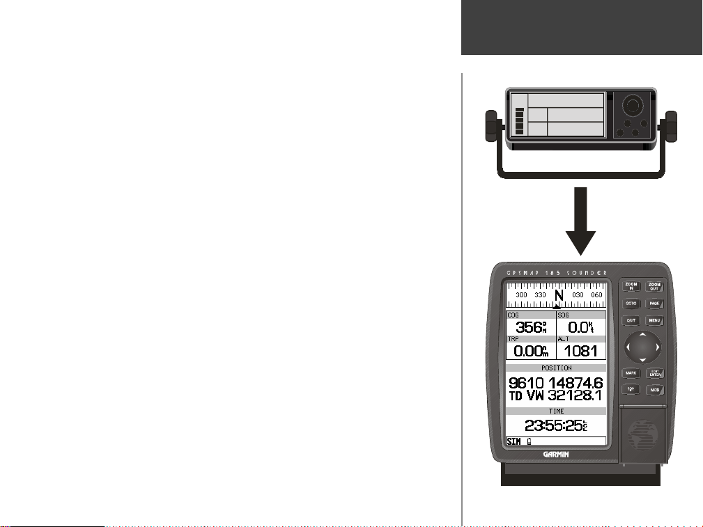
As a convenience to our customers that have used Loran C as
their primary source of navigation, we are now including a
Loran TD Position Format
Loran TD position format in our marine GPS products.
The new Loran TD Position Format will allow our customers to
enter Time Difference (TD) coordinates into their GARMIN GPS.
When a Loran C, TD coordinate is entered in a GARMIN GPS, the
coordinate will go through a conversion that makes it GPS friendly.
The converted coordinate can be used for immediate navigation
and/or stored for future use.
For those unfamiliar with Loran C, but want to use TD coordinates in your GARMIN GPS, it will help to have a basic understanding of Loran C and it’s components. This booklet is designed
to provide you with enough basic knowledge of Loran C to allow
you to setup and use the GARMIN Loran TD Position Format.
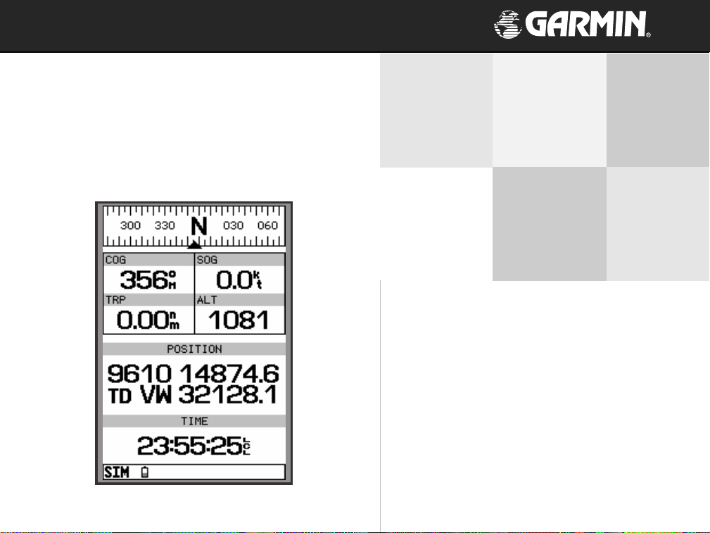
SIGNAL
GRI
9610
SEC
TD
14874.6
V
SEC
TD
32128.1
W
1
Page 4
Loran TD Position Format
9940 (W)
9940 (X)
9940 (X)
9940 (W)
9940
9940 (M)
9610 (W)
9940 (Y)
9940 (Y)
9610 (V)
(M)
9610 (X)
8970 (Y)
8970 (M)
9960 (Z)
8970 (Z)
9610 (Z)
9610 (Y)
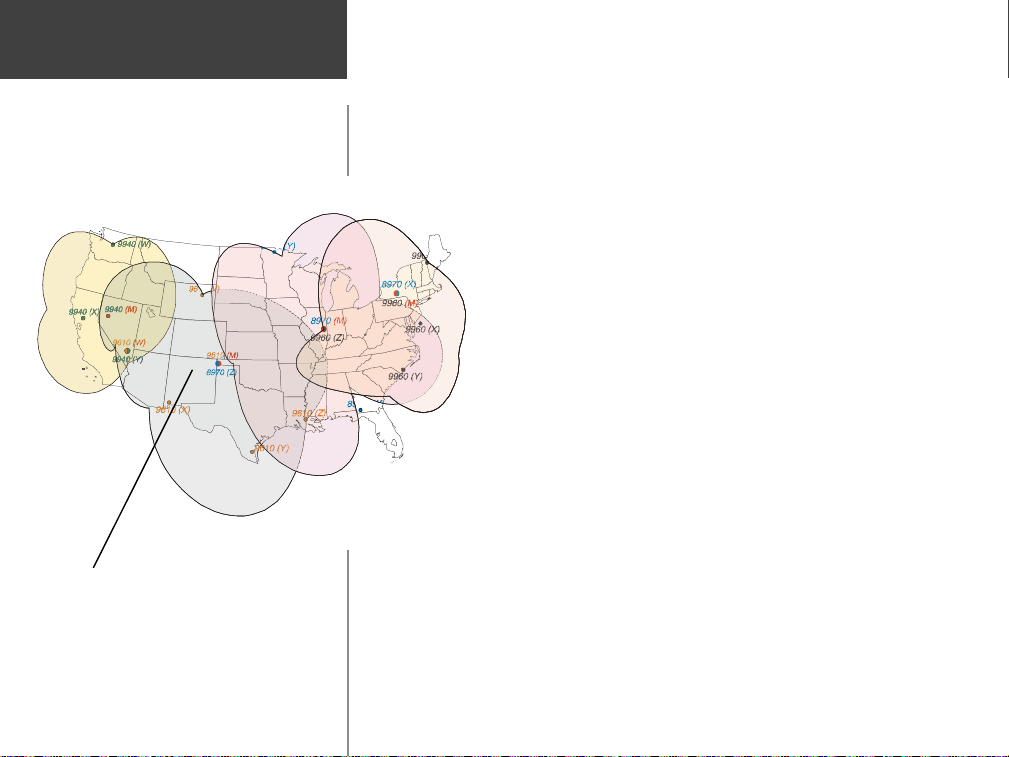
Loran C is a radio navigation system, operated and maintained
in the United States by the Untied States Coast Guard. The name
Loran is an acronym for ‘LOng RAnge Navigation’.
The Loran C system covers the entire United States and the U.S.
Coastal Confluence Zone. From a mariner’s perspective, the Loran C
system is used primarily for ocean and coastal navigation. It can be
used as a supplemental system for harbor and harbor
approach navigation, and for inland navigation by
9960 (W)
8970 (X)
9960 (M)
9960 (X)
9960 (Y)
8970 (W )
recreational vehicles. Loran C will be phased out as a
primary source of navigation, but should remain active
until after the turn of the century. It will be replaced by
GPS. The Global Positioning System provides greater
accuracy and world wide coverage.
The Loran C system consists of groups of land based
transmitter stations called chains. A chain contains a Master
station (M) and at least two, but more commonly 4 or 5 Secondary stations designated (V) Victor, (W) Whiskey, (X) Xray, (Y) Yankee,
and (Z) Zulu. These stations are separated by several hundred miles.
9610 Master Station and 8970 (Z) Zulu
Station share a common transmitter.
2
Many of the Loran C transmitter stations serve multiple roles.
A transmitter can serve as a Master Station for one chain and a
secondary station for multiple chains. An example would be chain
9610’s Master Station and chain 8970’s Zulu Station. These operate
from the same transmitter located in Boise City, OK.
Page 5

Each Master Station transmits a pulsed radio frequency (RF)
signal at a set time interval. This time interval is referred to as the
Group Repetition Interval or GRI. The GRI is used to identify the
different Loran C transmitter chains. It is not important to understand how this number is determined, just that it represents the
Master Station and chain.
After a Master Station transmits it’s pulsed RF signal, each
Secondary station after recieving the master station signal, transmits a pulsed RF signal at a set time delay. As the signals are
processed by the Loran C receiver, the master signal is separated
and used to measure the difference in time with each secondary
signal. The time interval is very short, measured in millionths of a
second or micro seconds. This time difference is how the Loran C
determines a location.
To determine a location, a Loran C must receive signals from a
Master and two Secondary Stations of the same chain. From those
three signals, a set of two TD’s are constructed and using the TD’s a
location can be plotted.
Loran TD Position Format
Loran C Chart
3
Page 6

Loran TD Position Format
Position Format Field
Rocker Keypad
Loran C users can now use their TD’s in GARMIN GPS systems.
The new Loran TD position format provides users with the ability
to create waypoints using TD’s. When a waypoint is created using
the Loran TD position format, a background conversion is performed on the TD’s. This conversion allows the GPS to navigate to
the TD’s location. Don’t worry, this conversion process will maintain the integrity of the TD location and has proven to be accurate
to within 30 meters most of the time. The new waypoint can be
used for immediate navigation and/or stored for future use.
Let’s take a look at how to select and setup the Loran TD
Position Format. The Position Format field is located in the
Navigation Setup menu. Refer to your GPS Owner’s Manual for
directions on locating the Navigation Setup Menu.
Selecting the Loran TD Position Format:
1. Highlight the Position Format field and press ENTER.
2. Using the Arrows or Rocker Keypad highlight
Loran TD
and press ENTER.
After the Loran TD format is selected, a new field will appear to
the right of the Position Format. This field, called Setup TD
provides access to the Loran Setup page. The Loran Setup page
contains fields where the GRI-Chain Number and Secondary
Stations are set. To activate the Loran Setup page, highlight the
Setup TD field and press ENTER.
4
Page 7

The GRI-Chain Number and Secondary Station Identifiers that
are set in the Loran Setup page will be used as a reference for the
TD’s when creating waypoints using the Loran TD Position Format.
Loran TD Position Format
Note: If you do not have the correct GRI-Chain or Secondary stations
set the waypoint will not be accurate.
The first setting is the Loran Chain Number. Accessing the
field activates a dropdown menu containing the 28 available
GRI-Chain numbers.
Setting the GRI-Chain Number:
1. Highlight the Loran Chain Number field and press ENTER.
2 Using the Arrows or Rocker Keypad, highlight the desired chain number and
press ENTER.
The next settings are Secondary Stations 1 and 2. Accessing
these fields activates a dropdown menu containing the 5 Secondary
Station Identifiers.
To set a Secondary Station:
1. Highlight either Secondary Station 1 or 2 field and press ENTER.
2. Using the Arrows or Rocker Keypad select the desired identifier and press
ENTER.
If a Secondary Station is selected, but the identifier is not
valid for the active GRI-chain, the corresponding TD field on the
Position Page will be filled with zeros. To remedy this, select a
valid Secondary Station Identifier.
Loran Chain Number Field
Secondary Station Fields
5
Page 8

Loran TD Position Format
These two screens show the same
waypoint. You can see that when the Loran
Chain Number or Secondary Stations are
changed, all waypoints stored in the GPS’s
memory will reference the new settings.
Remember that when you created the
waypoint the GPS converted the TD’s to a
GPS friendly Position Format and stored
that converted location in memory. The
converted location is used for navigation.
This allows the GPS to reference any Loran
Chain or Secondary Station and still
navigate to the original location.
Creating Waypoints
When creating a waypoint using the Loran TD Position Format
there are some things to be aware of and look for.
1. Verify that the correct Loran Chain Number and Secondary Stations are
displayed. If not they will need to be changed using the
2. If 000000 is displayed in a TD field, that Secondary Station Identifier is not a
valid selection for the chain. To remedy, select a valid Secondary Station
Identifier.
Setup TD
page.
When the new waypoint is saved, the TD’s are converted to a
GPS friendly Position Format and stored in the units memory.
When the Loran Chain Number and/or the Secondary Stations
are changed, all waypoints stored in memory will reflect that
change. The side-bar will help to explain how that affects the
waypoints.
Navigating
While the Loran TD Position Format is selected the unit will
display the Loran Chain Number and Secondary Stations selected
in the Setup TD page and the TD’s for the current location.
It is important to remember that the unit is not using the Loran
C signal for navigation, but can display TD’s as a current location.
The GPS uses the same process that it used to create a waypoint, in
reverse. The GPS takes that GPS friendly position format and
converts it to a TD for display.
6
Page 9

Remember, it is a good practice to update any waypoint created
using TD’s while you are actually at the waypoint location. Consult
your GPS Owner’s Manual for directions on updating a waypoint.
Loran TD Position Format
For more information, visit the
U.S. Coast Guard web site at:
www.navcen.uscg.mil
7
Page 10

Loran TD Position Format
Notes
8
Page 11

© 1999 GARMIN Corporation
GARMIN International, Inc.
1200 East 151st Street, Olathe, Kansas 66062, U.S.A.
GARMIN (Europe) Ltd.
Unit 5, The Quadrangle, Abbey Park Industrial Estate, Romsey, SO51 9AQ, U.K.
GARMIN (Asia) Corporation
No. 68, Jangshu 2nd Road, Shijr, Taipei County, Taiwan
www.garmin.com
Part Number 190-00190-00 Rev. A
 Loading...