

Page 1
D2™ DELTA/DELTA S/DELTA PX
Owner’s Manual
Page 2

© 2018 Garmin Ltd. or its subsidiaries
All rights reserved. Under the copyright laws, this manual may not be copied, in whole or in part, without the written consent of Garmin. Garmin reserves the right to change or improve its
products and to make changes in the content of this manual without obligation to notify any person or organization of such changes or improvements. Go to www.garmin.com for current updates
and supplemental information concerning the use of this product.
Garmin®, the Garmin logo, ANT+®, Auto Lap®, Auto Pause® ,Connext®, Edge®, TracBack®, VIRB®, and Virtual Partner® are trademarks of Garmin Ltd. or its subsidiaries, registered in the USA and
other countries. Connect IQ™, D2™, Garmin Connect™, Garmin Explore™, Garmin Express™, Garmin Golf™, Garmin Move IQ™ , Garmin Pay™, Garmin Pilot™, HRM-Run™, HRM-Tri™, QuickFit™,
tempe™, TruSwing™, Varia™, Varia Vision™, and Vector™ are trademarks of Garmin Ltd. or its subsidiaries. These trademarks may not be used without the express permission of Garmin.
American Heart Association® is a registered trademark of American Heart Association, Inc. Android™ is a trademark of Google Inc. Apple® and Mac® are trademarks of Apple Inc., registered in the
U.S. and other countries. The Bluetooth® word mark and logos are owned by the Bluetooth SIG, Inc. and any use of such marks by Garmin is under license. The Cooper Institute®, as well as any
related trademarks, are the property of The Cooper Institute. Di2™ is a trademark of Shimano, Inc. Shimano® is a registered trademark of Shimano, Inc. STRAVA and Strava™ are trademarks of
Strava, Inc. Advanced heartbeat analytics by Firstbeat. Training Stress Score™ (TSS), Intensity Factor™ (IF), and Normalized Power™ (NP) are trademarks of Peaksware, LLC. Wi‑Fi® is a
registered mark of Wi-Fi Alliance Corporation. Windows® is a registered trademark of Microsoft Corporation in the United States and other countries. Other trademarks and trade names are those
of their respective owners.
This product is ANT+® certified. Visit www.thisisant.com/directory for a list of compatible products and apps.
Page 3

Table of Contents
Introduction.....................................................................1
Device Overview......................................................................... 1
Viewing the Controls Menu.................................................... 1
Viewing Widgets.................................................................... 1
Charging the Device................................................................... 1
Updating the Aviation Database................................................. 1
Pairing Your Smartphone with Your Device............................... 1
Product Updates......................................................................... 2
Setting Up Garmin Express................................................... 2
Flying............................................................................... 2
Setting the Altitude Alert............................................................. 2
Setting the Barometric Pressure Manually................................. 2
Viewing NEXRAD Weather Radar.............................................. 2
Flying Activity.............................................................................. 2
Setting the Auto Fly Value..................................................... 2
Starting a Flight...................................................................... 2
Viewing Your SpO2 Readings in Flight.................................. 2
Navigating to the Nearest Airport........................................... 3
Nearest Airport.................................................................. 3
Navigating to an Aviation Waypoint by Its Identifier............... 3
Viewing Waypoint Information............................................... 3
Horizontal Situation Indicator................................................. 3
Stopping Navigation............................................................... 3
Disabling the Automatic Flight Timer..................................... 3
Routes and Flight Plans..............................................................3
Finding a Waypoint................................................................ 3
Creating a Flight Plan on Your Device................................... 3
Following a Flight Plan........................................................... 4
Viewing a Flight Plan on the Map.......................................... 4
Reversing and Following a Flight Plan.................................. 4
Editing a Flight Plan............................................................... 4
Deleting a Flight Plan............................................................. 4
Activities and Apps........................................................ 4
Starting an Activity...................................................................... 4
Tips for Recording Activities.................................................. 4
Stopping an Activity.................................................................... 4
Adding or Removing a Favorite Activity...................................... 4
Creating a Custom Activity......................................................... 5
Indoor Activities.......................................................................... 5
Recording a Strength Training Activity...................................5
Outdoor Activities........................................................................5
Viewing Your Ski Runs.......................................................... 5
Using the Metronome.............................................................5
Playing Audio Prompts During an Activity..............................5
Jumpmaster........................................................................... 6
Multisport.................................................................................... 6
Creating a Multisport Activity................................................. 6
Tips for Triathlon Training or Using Multisport Activities........ 6
Swimming................................................................................... 6
Swim Terminology................................................................. 6
Stroke Types.......................................................................... 6
Tips for Swimming Activities.................................................. 6
Resting During Pool Swimming............................................. 6
Training with the Drill Log...................................................... 6
Golfing........................................................................................ 7
Playing Golf............................................................................7
Hole Information.....................................................................7
Moving the Flag..................................................................... 7
Viewing Hazards.................................................................... 7
Measuring a Shot................................................................... 7
Viewing Layup and Dogleg Distances................................... 7
Keeping Score....................................................................... 7
Updating a Score................................................................... 7
TruSwing™
Using the Golf Odometer....................................................... 7
Tracking Statistics.................................................................. 7
............................................................................ 7
Connected Features....................................................... 7
Enabling Bluetooth Notifications................................................. 8
Viewing Notifications.............................................................. 8
Receiving an Incoming Phone Call........................................ 8
Replying to a Text Message.................................................. 8
Managing Notifications...........................................................8
Turning Off the Bluetooth Smartphone Connection.................... 8
Turning On and Off Smartphone Connection Alerts................... 8
Locating a Lost Mobile Device.................................................... 8
Garmin Connect..........................................................................9
Updating the Software Using Garmin Connect Mobile.......... 9
Updating the Software Using Garmin Express...................... 9
Using Garmin Connect on Your Computer....................... 9
Manually Syncing Data with Garmin Connect Mobile............ 9
Garmin Golf™ App.................................................................9
Starting a GroupTrack Session...................................................9
Tips for GroupTrack Sessions............................................... 9
Garmin Explore™..................................................................... 10
Connext.................................................................................... 10
Connecting to the Garmin Pilot App.................................... 10
Pairing a Connext Device.................................................... 10
Wi‑Fi Connected Features........................................... 10
Setting Up Wi‑Fi Connectivity................................................... 10
Connect IQ Features.................................................... 10
Downloading Connect IQ Features.......................................... 10
Downloading Connect IQ Features Using Your Computer....... 10
Garmin Pay................................................................... 10
Setting Up Your Garmin Pay Wallet......................................... 11
Paying for a Purchase Using Your Watch................................ 11
Adding a Card to Your Garmin Pay Wallet............................... 11
Managing Your Garmin Pay Wallet......................................11
Changing Your Garmin Pay Passcode..................................... 11
Music............................................................................. 11
Connecting to a Third-Party Provider....................................... 11
Downloading Audio Content from a Third-Party Provider.... 12
Disconnecting from a Third-Party Provider.......................... 12
Downloading Personal Audio Content...................................... 12
Listening to Music..................................................................... 12
Music Playback Controls.......................................................... 12
Connecting Headphones using Bluetooth Technology............. 12
Heart Rate Features..................................................... 12
Wrist-based Heart Rate............................................................ 12
Wearing the Device..............................................................12
Tips for Erratic Heart Rate Data...........................................13
Viewing the Heart Rate Widget............................................ 13
Broadcasting Heart Rate Data to Garmin Devices.............. 13
Broadcasting Heart Rate Data During an Activity........... 13
Turning Off the Wrist-based Heart Rate Monitor................. 13
Putting On the Heart Rate Monitor........................................... 13
Tips for Erratic Heart Rate Data...........................................13
Caring for the Heart Rate Monitor........................................ 14
Running Dynamics....................................................................14
Training with Running Dynamics......................................... 14
Color Gauges and Running Dynamics Data........................ 14
Ground Contact Time Balance Data............................... 15
Vertical Oscillation and Vertical Ratio Data.....................15
Tips for Missing Running Dynamics Data............................ 15
Performance Measurements.................................................... 15
Turning Off Performance Notifications................................. 16
Detecting Performance Measurements Automatically......... 16
Training Status..................................................................... 16
Table of Contents i
Page 4

Tips for Getting Your Training Status.............................. 16
About VO2 Max. Estimates.................................................. 16
Getting Your VO2 Max. Estimate for Running................ 16
Getting Your VO2 Max. Estimate for Cycling.................. 17
Recovery Time..................................................................... 17
Viewing Your Recovery Time.......................................... 17
Recovery Heart Rate........................................................... 17
Training Load....................................................................... 17
Viewing Your Predicted Race Times................................... 17
About Training Effect........................................................... 17
Heart Rate Variability and Stress Level............................... 18
Viewing Your Heart Rate Variability and Stress Level.... 18
Performance Condition........................................................ 18
Viewing Your Performance Condition............................. 18
Lactate Threshold................................................................ 18
Performing a Guided Test to Determine Your Lactate
Threshold
Getting Your FTP Estimate.................................................. 18
Conducting an FTP Test................................................. 19
........................................................................ 18
Pulse Oximeter............................................................. 19
Viewing the Pulse Oximeter Widget......................................... 19
Turning On All-Day Acclimation Mode...................................... 19
Turning On Manual Acclimation Mode..................................... 19
Tips for Erratic Pulse Oximeter Data........................................ 19
Training......................................................................... 19
Setting Up Your User Profile.....................................................19
Fitness Goals....................................................................... 19
About Heart Rate Zones...................................................... 20
Setting Your Heart Rate Zones....................................... 20
Letting the Device Set Your Heart Rate Zones............... 20
Heart Rate Zone Calculations......................................... 20
Setting Your Power Zones................................................... 20
Activity Tracking........................................................................20
Auto Goal............................................................................. 20
Using the Move Alert............................................................21
Sleep Tracking..................................................................... 21
Using Automated Sleep Tracking....................................21
Using Do Not Disturb Mode............................................ 21
Intensity Minutes.................................................................. 21
Earning Intensity Minutes................................................ 21
Garmin Move IQ™............................................................... 21
Activity Tracking Settings..................................................... 21
Turning Off Activity Tracking........................................... 21
Workouts...................................................................................21
Following a Workout From the Web.....................................21
Starting a Workout............................................................... 21
About the Training Calendar................................................ 22
Using Garmin Connect Training Plans............................ 22
Interval Workouts...................................................................... 22
Creating an Interval Workout............................................... 22
Starting an Interval Workout................................................ 22
Stopping an Interval Workout...............................................22
Segments..................................................................................22
Strava™ Segments.............................................................. 22
Viewing Segment Details..................................................... 22
Racing a Segment............................................................... 22
Setting a Segment to Adjust Automatically.......................... 23
Using Virtual Partner®.............................................................. 23
Setting a Training Target.......................................................... 23
Cancelling a Training Target................................................ 23
Racing a Previous Activity........................................................ 23
Personal Records..................................................................... 23
Viewing Your Personal Records.......................................... 23
Restoring a Personal Record............................................... 23
Clearing a Personal Record................................................. 23
Clearing All Personal Records............................................. 23
Clock.............................................................................. 24
Setting an Alarm....................................................................... 24
Deleting an Alarm................................................................ 24
Starting the Countdown Timer.................................................. 24
Using the Stopwatch................................................................. 24
Adding Alternate Time Zones................................................... 24
Setting Clock Alerts.................................................................. 24
Syncing the Time with GPS...................................................... 24
Navigation..................................................................... 24
Saving Your Location............................................................... 24
Editing Your Saved Locations.............................................. 24
Projecting a Waypoint............................................................... 24
Navigating to a Destination....................................................... 24
Navigating to a Point of Interest............................................... 25
Points of Interest.................................................................. 25
Creating and Following a Course on Your Device.................... 25
Creating a Round-Trip Course..................................................25
Marking and Starting Navigation to a Man Overboard
Location.................................................................................... 25
Navigating with Sight 'N Go...................................................... 25
Navigating to Your Starting Point During an Activity................ 25
Navigating to the Starting Point of Your Last Saved Activity.... 25
Stopping Navigation................................................................. 26
Map........................................................................................... 26
Viewing the Map.................................................................. 26
Saving or Navigating to a Location on the Map................... 26
Navigating with the Around Me Feature.............................. 26
Compass...................................................................................26
Altimeter and Barometer........................................................... 26
Altimeter Readings...............................................................26
History........................................................................... 26
Using History............................................................................ 26
Multisport History................................................................. 27
Viewing Your Time in Each Heart Rate Zone...................... 27
Viewing Data Totals.................................................................. 27
Using the Odometer..................................................................27
Deleting History........................................................................ 27
Customizing Your Device............................................ 27
Aviation Settings....................................................................... 27
Activities and App Settings....................................................... 27
Customizing the Data Screens............................................ 28
Adding a Map to an Activity................................................. 28
Alerts.................................................................................... 28
Setting an Alert................................................................28
Activity Map Settings............................................................29
Routing Settings...................................................................29
Auto Lap...............................................................................29
Marking Laps by Distance............................................... 29
Enabling Auto Pause........................................................... 29
Enabling Auto Climb............................................................ 29
3D Speed and Distance....................................................... 30
Turning On and Off the Lap Key.......................................... 30
Using Auto Scroll................................................................. 30
UltraTrac.............................................................................. 30
Power Save Timeout Settings..............................................30
Changing the Order of an Activity in the Apps List................... 30
Widgets..................................................................................... 30
Customizing the Widget Loop.............................................. 31
Altimeter............................................................................... 31
Temperature........................................................................ 31
METAR................................................................................ 31
VIRB Remote....................................................................... 31
Controlling a VIRB Action Camera.................................. 31
Controlling a VIRB Action Camera During an Activity..... 31
Using the Stress Level Widget............................................. 32
ii Table of Contents
Page 5

Customizing the Controls Menu................................................32
Watch Face Settings.................................................................32
Default Watch Face............................................................. 32
Customizing the Watch Face............................................... 32
Sensors Settings.......................................................................32
Compass Settings................................................................ 32
Calibrating the Compass Manually................................. 32
Setting the North Reference............................................33
Altimeter Settings................................................................. 33
Calibrating the Barometric Altimeter............................... 33
Barometer Settings.............................................................. 33
Calibrating the Barometer............................................... 33
Elevation Settings................................................................ 33
Map Settings............................................................................. 33
Marine Map Settings............................................................ 33
Showing and Hiding Map Data............................................ 34
GroupTrack Settings................................................................. 34
Navigation Settings................................................................... 34
Customizing Map Features.................................................. 34
Setting Up a Heading Bug................................................... 34
Setting Navigation Alerts......................................................34
System Settings........................................................................ 34
Time Settings....................................................................... 34
Changing the Backlight Settings.......................................... 34
Customizing the Hot Keys....................................................34
Changing the Units of Measure........................................... 35
Viewing Device Information...................................................... 35
Viewing E-label Regulatory and Compliance Information.... 35
Wireless Sensors......................................................... 35
Pairing Your Wireless Sensors................................................. 35
Using an Optional Bike Speed or Cadence Sensor.................. 35
Training with Power Meters...................................................... 35
Using Electronic Shifters...........................................................35
Situational Awareness.............................................................. 35
Foot Pod................................................................................... 35
Improving Foot Pod Calibration........................................... 35
Calibrating Your Foot Pod Manually.................................... 35
Setting Foot Pod Speed and Distance................................. 36
tempe........................................................................................ 36
Device Information....................................................... 36
D2 Delta/Delta S/Delta PX Specifications................................ 36
Battery Information...............................................................36
Data Management.................................................................... 36
Disconnecting the USB Cable..............................................36
Deleting Files....................................................................... 36
Device Maintenance..................................................... 36
Device Care.............................................................................. 36
Cleaning the Device............................................................. 37
Cleaning the Leather Bands................................................ 37
Changing the QuickFit™ Bands............................................... 37
Metal Watch Band Adjustment................................................. 37
Troubleshooting........................................................... 37
My device is in the wrong language......................................... 37
Is my smartphone compatible with my device?........................ 37
My phone will not connect to the device................................... 37
Can I use my Bluetooth sensor with my watch?....................... 37
My headphones will not connect to the device......................... 37
My music cuts out or my headphones do not stay connected.. 37
Resetting Your Device.............................................................. 37
Resetting All Default Settings................................................... 37
Acquiring Satellite Signals........................................................ 38
Improving GPS Satellite Reception......................................38
The temperature reading is not accurate.................................. 38
Maximizing the Battery Life.......................................................38
Activity Tracking........................................................................38
My daily step count does not appear
My step count does not seem accurate............................... 38
The step counts on my device and my Garmin Connect
account don't match............................................................. 38
The floors climbed amount does not seem accurate........... 38
My intensity minutes are flashing......................................... 38
Contacting Garmin Aviation Product Support........................... 38
Getting More Information.......................................................... 38
................................... 38
Appendix....................................................................... 39
Data Fields................................................................................39
VO2 Max. Standard Ratings..................................................... 42
FTP Ratings.............................................................................. 42
Wheel Size and Circumference................................................ 42
Symbol Definitions.................................................................... 43
Index.............................................................................. 44
Table of Contents iii
Page 6

Page 7
Introduction
WARNING
See the Important Safety and Product Information guide in the
product box for product warnings and other important
information.
Always consult your physician before you begin or modify any
exercise program.
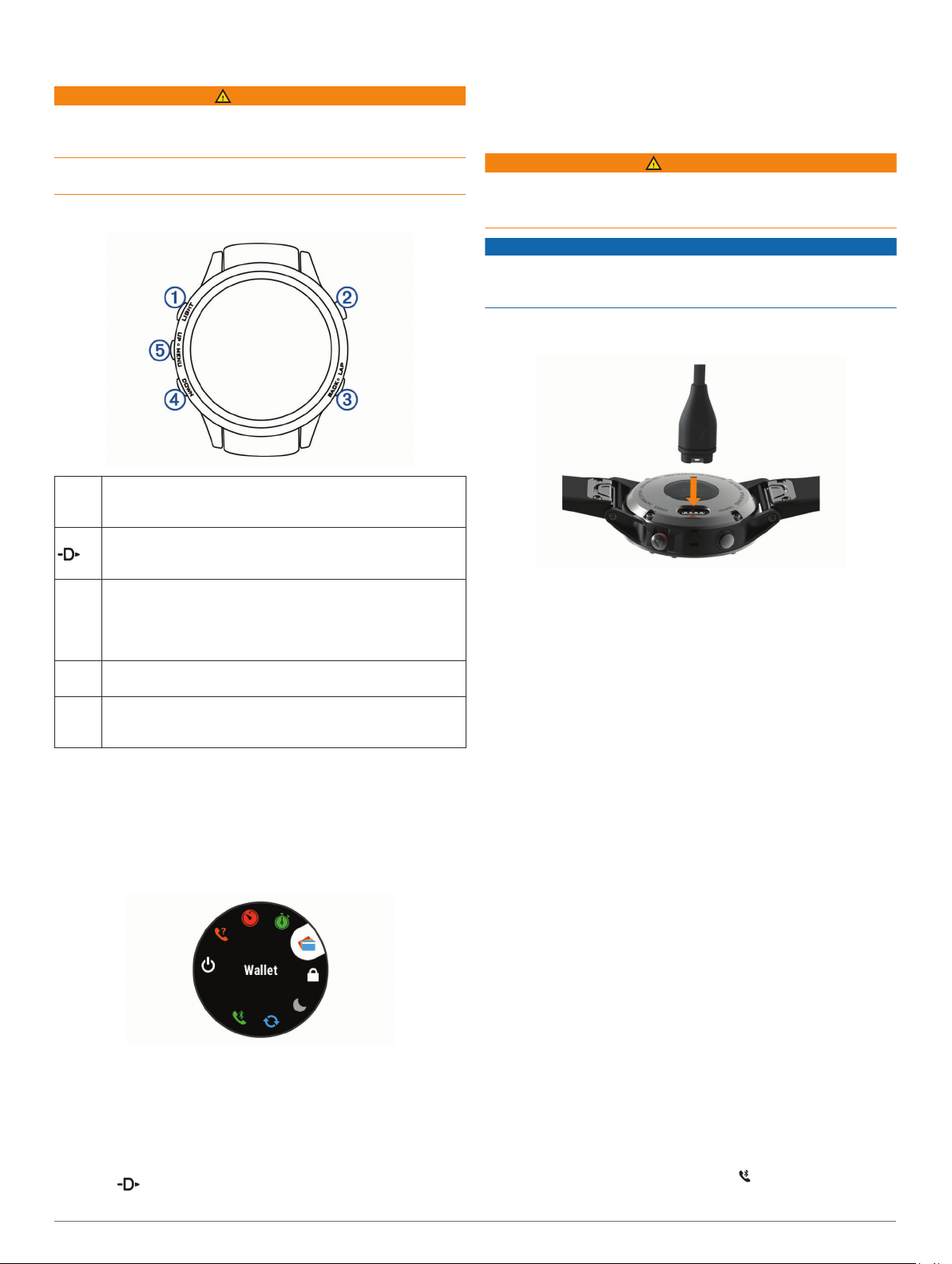
Device Overview
Select to turn the backlight on and off.
À
LIGHT
Hold to view the controls menu.
Hold to turn the device on.
Select to view the activity list and start or stop an activity.
Á
Select to choose an option in a menu.
Hold to navigate to an aviation waypoint by its identifier.
Select to return to the previous screen.
Â
BACK
Select to record a lap, rest, or transition during a multisport
activity.
LAP
Hold to view the watch face from any screen.
Hold to navigate to the nearest airport.
Select to scroll through the widget loop and menus.
Ã
DOWN
Hold to view the music controls from any screen.
Select to scroll through the widget loop and menus.
Ä
UP
Hold to view the menu.
MENU
Viewing the Controls Menu
The controls menu contains options, such as turning on do not
disturb mode, locking the keys, and turning the device off. You
can also open the Garmin Pay™ wallet.
NOTE: You can add, reorder, and remove the options in the
controls menu (Customizing the Controls Menu, page 32).
From any screen, hold LIGHT.
1
• From any screen, hold BACK to return to the watch face.
• If you are recording an activity, select BACK to return to the
activity data pages.
Charging the Device
WARNING
This device contains a lithium-ion battery. See the Important
Safety and Product Information guide in the product box for
product warnings and other important information.
NOTICE
To prevent corrosion, thoroughly clean and dry the contacts and
the surrounding area before charging or connecting to a
computer. Refer to the cleaning instructions in the appendix.
Plug the small end of the USB cable into the charging port on
1
your device.
Plug the large end of the USB cable into a USB port on your
2
computer.
Charge the device completely.
3
Updating the Aviation Database
Before you can update the aviation database, you must create a
Garmin® account and add your device. You can view your unit ID
on the device information screen (Viewing Device Information,
page 35).
The aviation database is valid for 28 days at a time and includes
worldwide airport locations, navigational aids, and intersection
data.
Go to www.flyGarmin.com.
1
Log in to your Garmin account.
2
Select an option:
3
• Connect your device to a computer using the included
USB cable.
• Connect your device to a Wi‑Fi® wireless network.
Follow the on-screen instructions to update the aviation
4
database.
When your device is connected to a Wi‑Fi wireless network,
database updates are downloaded automatically overnight.
Pairing Your Smartphone with Your Device
To use the connected features of the D2 device, it must be
paired directly through the Garmin Connect™ Mobile app,
Select UP or DOWN to scroll through the options.
2
Viewing Widgets
Your device comes preloaded with several widgets, and more
are available when you pair your device with a smartphone.
• Select UP or DOWN.
The device scrolls through the widget loop.
• Select to view additional options and functions for a
widget.
Introduction 1
instead of from the Bluetooth® settings on your smartphone.
From the app store on your smartphone, install and open the
1
Garmin Connect Mobile app.
Bring your smartphone within 10 m (33 ft.) of your device.
2
Select LIGHT to turn on the device.
3
The first time you turn on the device, it is in pairing mode.
TIP: You can hold LIGHT and select to manually enter
pairing mode.
Page 8
Select an option to add your device to your Garmin Connect
4
account:
• If this is the first time you are pairing a device with the
Garmin Connect Mobile app, follow the on-screen
instructions.
• If you already paired another device with the Garmin
Connect Mobile app, from the or menu, select
Garmin Devices > Add Device, and follow the on-screen
instructions.
Product Updates
On your computer, install Garmin Express™ (www.garmin.com
/express). On your smartphone, install the Garmin Connect
Mobile app.
This provides easy access to these services for Garmin devices:
• Software updates
• Map updates
• Data uploads to Garmin Connect
• Product registration
Setting Up Garmin Express
Connect the device to your computer using a USB cable.
1
Go to www.garmin.com/express.
2
Follow the on-screen instructions.
3
Flying
WARNING
Do not use this device as a primary means of navigation. See
the Important Safety and Product Information guide in the
product box for product warnings and other important
information prior to use.
Setting the Altitude Alert
You can set an alarm to vibrate when you reach a specified
altitude.
NOTE: The altitude alert is not available in watch mode.
Hold MENU.
1
Select Settings > Aviation > Altimeter > Altitude Alert >
2
Status > On.
Select Altitude.
3
Select UP to select an altitude.
4
Setting the Barometric Pressure Manually
You can set the current barometric pressure manually. This can
help to improve the accuracy of the pressure altitude reading.
Hold MENU.
1
Select Settings > Aviation > Altimeter > Barometer >
2
Manual.
Select UP or DOWN to set the current barometric pressure.
3
NOTE:
see all applicable radar data.
If necessary, hold DOWN and to download new data.
2
If you are near the border of the square, you may not
Flying Activity
A flying activity starts automatically when your detected climb
rate exceeds the value you set in the auto fly settings. The
default auto fly value is 500 fpm.
You can set up your D2 device to automatically connect to a
paired Connext® device when a flying activity starts. This allows
your D2 device to display aircraft information.
Setting the Auto Fly Value
Hold MENU.
1
Select Settings > Activities & Apps > FLY.
2
Select the activity settings.
3
Select Auto Fly.
4
Select the auto fly value.
5
A flying activity starts automatically when your detected climb
rate exceeds this value.
Starting a Flight
From the clock, select .
1
Select FLY.
2
If necessary, go outside and wait while the device locates
3
satellites.
Select to start the flight timer.
4
NOTE: Your activity data is recorded only while the flight
timer is running.
Start your activity.
5
After you complete your activity, select > Save.
6
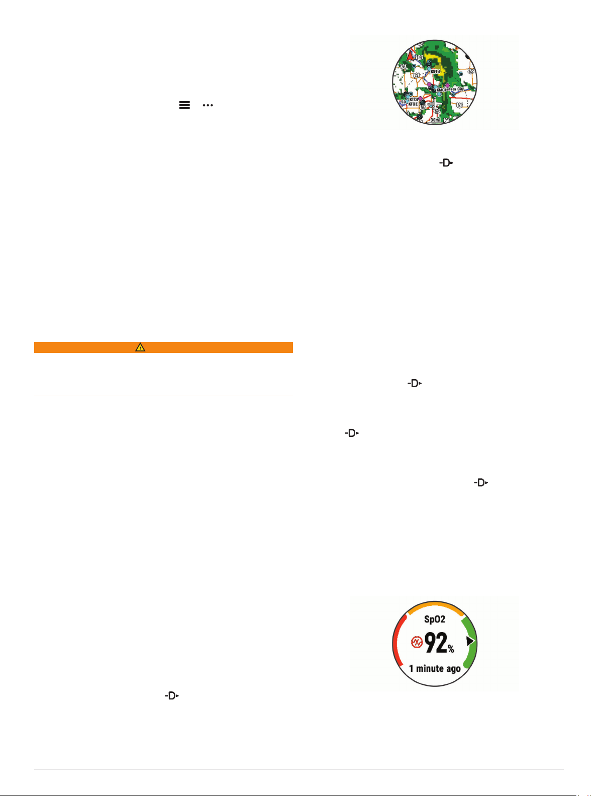
Viewing Your SpO2 Readings in Flight
The D2 Delta PX device has a wrist-based pulse oximeter to
gauge the saturation of oxygen in your blood (SpO2). During a
flight, the device automatically takes pulse oximeter readings
more frequently, so you can monitor your SpO2 percentage.
During a flight, scroll up or down to view the SpO2 data
screen.
Your most recent reading appears as an oxygen saturation
percentage and position on the color gauge.
Viewing NEXRAD Weather Radar
Before you can view NEXRAD weather radar, you must pair
your device with your smartphone (Pairing Your Smartphone
with Your Device, page 1).
You can view the weather radar image associated with your
current location.
At any time, hold DOWN and at the same time.
1
The device downloads a square of radar data for your current
GPS position, outlined in magenta. The radar data is active
for 5 minutes.
2 Flying
NOTE: If you are too active for the device to determine your
oxygen saturation, dashes appear instead of a percentage.
You should remain stationary for up to 30 seconds while the
device reads your blood oxygen saturation.
Page 9
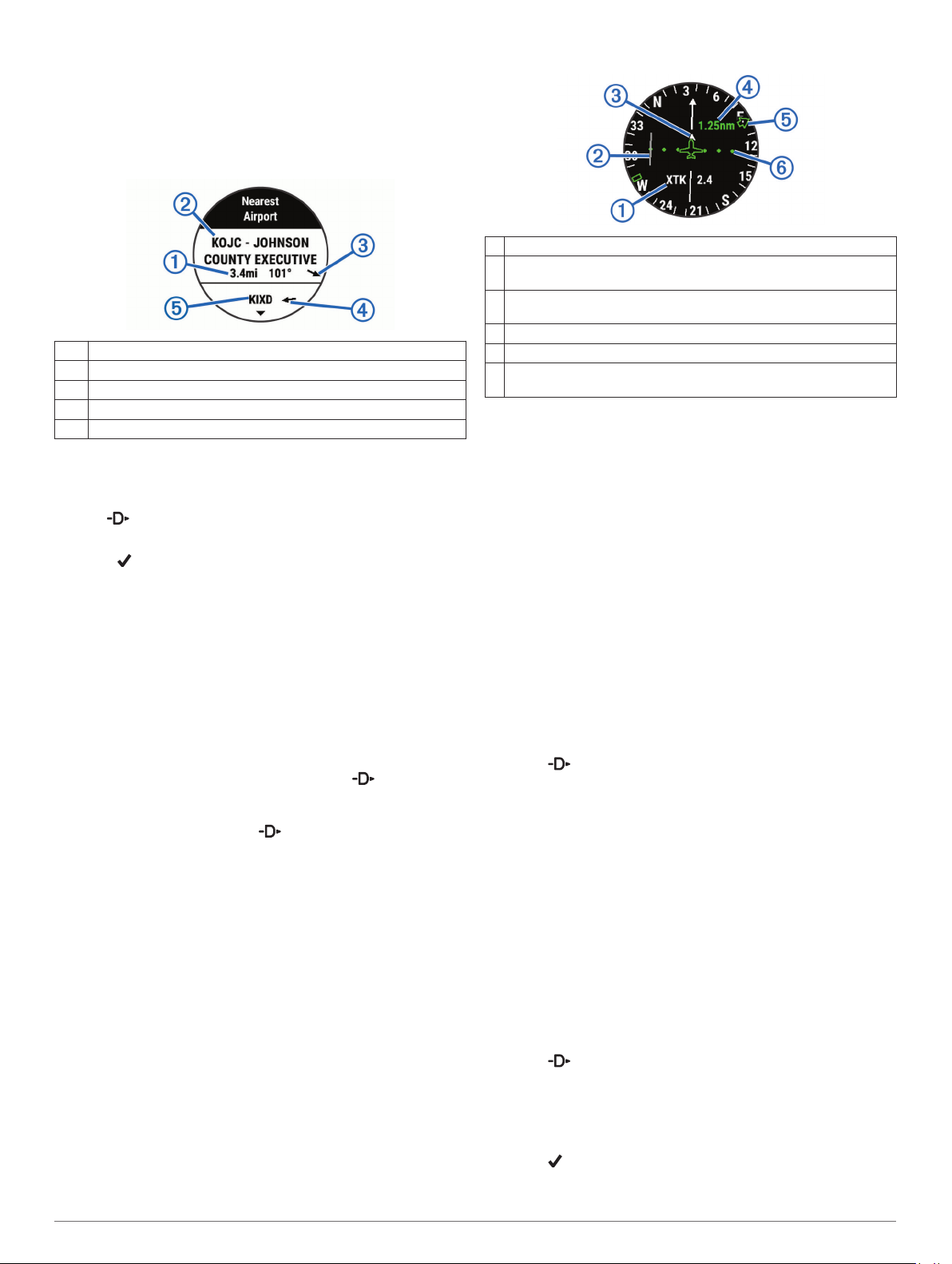
Navigating to the Nearest Airport
Hold BACK.
1
A list of the nearest airports appears.
Select an airport.
2
Select Direct-To to begin navigation.
3
Nearest Airport
Distance to the nearest airport
À
Nearest airport identifier
Á
Bearing to the nearest airport
Â
Bearing to the second nearest airport
Ã
Second nearest airport identifier
Ä
Navigating to an Aviation Waypoint by Its Identifier
You can navigate directly to an aviation waypoint by searching
for an alphanumeric identifier.
Hold .
1
Enter all or part of the alphanumeric identifier.
2
Select .
3
A list of matching waypoints appears.
Select the waypoint.
4
Select Direct-To to begin navigation.
5
Viewing Waypoint Information
You can view information about a location from the list of
nearest airports, list of aviation waypoints, or list of waypoints in
a flight plan.
Select an option to view a list of waypoints:
1
• To view a list of the nearest airports, hold BACK
(Navigating to the Nearest Airport, page 3).
• To view a list of aviation waypoints, hold , and enter all
or part of the alphanumeric identifier (Navigating to an
Aviation Waypoint by Its Identifier, page 3).
• To find a waypoint, select > FLY, hold MENU, select
Navigation > Flight Planning > Find Waypoint, and
select an option (Finding a Waypoint, page 3).
Select a waypoint.
2
Select an option:
3
NOTE: Options vary by the selected waypoint type.
• To navigate directly to the selected location, select Direct-
To.
• To download the NEXRAD weather radar image
associated with the selected location, select NEXRAD
(Viewing NEXRAD Weather Radar, page 2).
• To show the waypoint on the map, select Show Map.
• To view general information, such as the distance and
bearing from your current location, select General Info.
• To show radio frequencies, select Frequencies.
• To show runway information, such as the runway length
and surface material, select Runways.
• To show METAR and TAF information, select METARs/
TAFs.
Horizontal Situation Indicator
Cross-track distance.
À
Course deviation indicator (CDI). Indicates the location of the
Á
desired course line in relation to your location.
To-and-from indicator. Indicates whether you are headed toward or
Â
away from the waypoint.
Course deviation distance scale.
Ã
Bearing to the nearest airport.
Ä
Course deviation distance. The dots indicate your distance off
Å
course.
Stopping Navigation
Hold MENU, and select Stop Course.
Disabling the Automatic Flight Timer
You can disable the automatic flight timer so your device does
not automatically record flight data when your ground speed
exceeds 30 kn.
Hold MENU.
1
Select Settings > Activities & Apps > FLY.
2
Select the activity settings.
3
Select Flight Timer > Manual.
4
Routes and Flight Plans
A route is a sequence of waypoints or locations that leads you to
your final destination. Flight plans are routes that use direct
routing optimized for aviation. You can create flight plans on
your device or by using the Garmin Pilot™ app for mobile
devices.
Finding a Waypoint
Select > FLY.
1
Hold MENU.
2
Select Navigation > Flight Planning > Find Waypoint.
3
Select an option:
4
• To find a waypoint by name, select Search by Ident..
• To select from a list of the nearest airports, select Nearest
Airports.
• To select from a list of the nearest navigational aids,
select Nearest Navaids.
• To select from a list of the nearest intersections, select
Nearest Intersection.
Select a location.
5
If necessary, select an option to view additional waypoint
6
details (Viewing Waypoint Information, page 3).
Creating a Flight Plan on Your Device
Select > FLY.
1
Hold MENU.
2
Select Navigation > Flight Planning > Saved Plans >
3
Create New.
Enter the name of the flight plan.
4
Select .
5
Select Add Location.
6
Flying 3
Page 10
Select a category.
7
Select the first point on the route.
8
Repeat steps 6 through 8 until the route is complete.
9
Select Done to save the route.
10
Following a Flight Plan
Select > FLY.
1
Hold MENU.
2
Select Navigation > Flight Planning > Saved Plans.
3
Select a flight plan.
4
Select Set Active to begin following the flight plan.
5
Viewing a Flight Plan on the Map
Select > FLY.
1
Hold MENU.
2
Select Navigation > Flight Planning > Saved Plans.
3
Select a flight plan.
4
Select Map.
5
Reversing and Following a Flight Plan
Select > FLY.
1
Hold MENU.
2
Select Navigation > Flight Planning > Saved Plans.
3
Select a flight plan.
4
Select Invert and Save Copy to reverse the route and save
5
it as a copy of the original flight plan.
Select the copy of the flight plan.
6
Select Set Active to begin following the flight plan.
7
Editing a Flight Plan
Select > FLY.
1
Hold MENU.
2
Select Navigation > Flight Planning > Saved Plans.
3
Select a flight plan.
4
Select Edit.
5
Select an option:
6
• To view detailed information about a location, select a
location, and select Details.
• To change the order of a location on the route, select a
location, and select Move Up or Move Down.
• To edit the name of a location, select a location, and
select Name.
• To remove a location from the route, select a location, and
select Remove.
• To add a location to the route, select Add Location.
Deleting a Flight Plan
Select > FLY.
1
Hold MENU.
2
Select Navigation > Flight Planning > Saved Plans.
3
Select a flight plan.
4
Select Delete > Yes.
5
Activities and Apps
Your device can be used for indoor, outdoor, athletic, and fitness
activities. When you start an activity, the device displays and
records sensor data. You can save activities and share them
with the Garmin Connect community.
You can also add Connect IQ™ activities and apps to your
device using the Connect IQ Mobile app (Connect IQ Features,
page 10).
For more information about activity tracking and fitness metric
accuracy, go to garmin.com/ataccuracy.
Starting an Activity
When you start an activity, GPS turns on automatically (if
required). When you stop the activity, the device returns to
watch mode.
From the watch face, select .
1
Select an activity.
2
If necessary, follow the on-screen instructions to enter
3
additional information.
If necessary, wait while the device connects to your ANT+
4
sensors.
If the activity requires GPS, go outside, and wait while the
5
device locates satellites.
Select to start the timer.
6
NOTE: The device does not record your activity data until
you start the timer.
Tips for Recording Activities
• Charge the device before starting an activity (Charging the
Device, page 1).
• Select LAP to record laps.
• Select UP or DOWN to view additional data pages.
Stopping an Activity
Select .
1
Select an option:
2
• To resume your activity, select Resume.
• To save the activity and return to watch mode, select
Save.
• To suspend your activity and resume it at a later time,
select Resume Later.
• To mark a lap, select Lap.
• To navigate back to the starting point of your activity along
the path you traveled, select Back to Start > TracBack.
NOTE: This feature is available only for activities that use
GPS.
• To navigate back to the starting point of your activity by
the most direct path, select Back to Start > Route.
NOTE: This feature is available only for activities that use
GPS.
• To discard the activity and return to watch mode, select
Discard > Yes.
NOTE: After stopping the activity, the device saves it
automatically after 30 minutes.
Adding or Removing a Favorite Activity
The list of your favorite activities appears when you press
from the watch face, and it provides quick access to the
activities you use most. The FLY activity appears in the list by
default. The first time you press to start an activity, the
device prompts you to select additional activities. You can add
or remove favorite activities at any time.
Hold MENU.
1
Select Settings > Activities & Apps.
2
Your favorite activities appear at the top of the list with a
white background. Other activities appear with a black
background.
Select an option:
3
• To add a favorite activity, select the activity, and select
Set as Favorite.
®
4 Activities and Apps
Page 11

• To remove a favorite activity, select the activity, and select
Remove from Favorites.
Creating a Custom Activity
From the watch face, select > Add.
1
Select an option:
2
• Select Copy Activity to create your custom activity
starting from one of your saved activities.
• Select Other to create a new custom activity.
If necessary, select an activity type.
3
Select a name or enter a custom name.
4
Duplicate activity names include a number, for example:
Bike(2).
Select an option:
5
• Select an option to customize specific activity settings. For
example, you can select an accent color or customize the
data screens.
• Select Done to save and use the custom activity.
Select Yes to add the activity to your list of favorites.
6
Indoor Activities
The D2 device can be used for training indoors, such as running
on an indoor track or using a stationary bike. GPS is turned off
for indoor activities.
When running or walking with GPS turned off, speed, distance,
and cadence are calculated using the accelerometer in the
device. The accelerometer is self-calibrating. The accuracy of
the speed, distance, and cadence data improves after a few
outdoor runs or walks using GPS.
TIP: Holding the handrails of the treadmill reduces accuracy.
You can use an optional foot pod to record pace, distance, and
cadence.
When cycling with GPS turned off, speed and distance are not
available unless you have an optional sensor that sends speed
and distance data to the device (such as a speed or cadence
sensor).
Recording a Strength Training Activity
You can record sets during a strength training activity. A set is
multiple repetitions (reps) of a single move.
From the watch face, select > Strength.
1
The first time you record a strength training activity, you will
select which wrist your watch is on.
Select to start the set timer.
2
Start your first set.
3
The device counts your reps. Your rep count appears when
you complete at least six reps.
TIP: The device can only count reps of a single move for
each set. When you want to change moves, you should finish
the set and start a new one.
Select LAP to finish the set.
4
The watch displays the total reps for the set. After several
seconds, the rest timer appears.
If necessary, hold MENU, select Edit Last Set, and edit the
5
number of reps.
TIP: You can also add the weight used for the set.
When you are done resting, select LAP to start your next set.
6
Repeat for each strength training set until your activity is
7
complete.
After your last set, select to stop the set timer.
8
Select Save.
9
Outdoor Activities
The D2 device comes preloaded with outdoor activities, such as
running and cycling. GPS is turned on for outdoor activities. You
can add new activities based on default activities, such as
walking or rowing. You can also add custom activities to your
device (Creating a Custom Activity, page 5).
Viewing Your Ski Runs
Your device records the details of each downhill skiing or
snowboarding run using the auto run feature. This feature is
turned on by default for downhill skiing and snowboarding. It
automatically records new ski runs based on your movement.
The timer pauses when you stop moving downhill and when you
are on a chairlift. The timer remains paused during the chairlift
ride. You can start moving downhill to restart the timer. You can
view run details from the paused screen or while the timer is
running.
Start a skiing or snowboarding activity.
1
Hold MENU.
2
Select View Runs.
3
Select UP and DOWN to view details of your last run, your
4
current run, and your total runs.
The run screens include time, distance traveled, maximum
speed, average speed, and total descent.
Using the Metronome
The metronome feature plays tones at a steady rhythm to help
you improve your performance by training at a faster, slower, or
more consistent cadence.
NOTE: This feature is not available for all activities.
From the watch face, select .
1
Select an activity.
2
Hold MENU.
3
Select the activity settings.
4
Select Metronome > Status > On.
5
Select an option:
6
• Select Beats / Minute to enter a value based on the
cadence you want to maintain.
• Select Alert Frequency to customize the frequency of the
beats.
• Select Sounds to customize the metronome tone and
vibration.
If necessary, select Preview to listen to the metronome
7
feature before you run.
Go for a run (Starting an Activity, page 4).
8
The metronome starts automatically.
During your run, select UP or DOWN to view the metronome
9
screen.
If necessary, hold MENU to change the metronome settings.
10
Playing Audio Prompts During an Activity
You can enable your D2 device to play motivational status
announcements during a run or other activity. Audio prompts
play on your connected headphones using Bluetooth
technology, if available. Otherwise, audio prompts play on your
smartphone paired through the Garmin Connect Mobile app.
During an audio prompt, the device or smartphone mutes the
primary audio to play the announcement.
NOTE: This feature is not available for all activities.
Hold MENU.
1
Select Settings > Audio Prompts.
2
Select an option:
3
• To hear a prompt for each lap, select Lap Alert.
NOTE: The Lap Alert audio prompt is enabled by default.
Activities and Apps 5
Page 12
• To customize prompts with your pace and speed
information, select Pace/Speed Alert.
• To customize prompts with your heart rate information,
select Heart Rate Alert.
• To hear prompts when you start and stop the timer,
including the Auto Pause® feature, select Timer Events.
• To change the language or the dialect of the voice
prompts, select Dialect.
Jumpmaster
WARNING
The jumpmaster feature is for use by experienced skydivers
only. The jumpmaster feature should not be used as a primary
skydiving altimeter. Failure to input the appropriate jump related
information can lead to serious personal injury or death.
The jumpmaster feature follows military guidelines for
calculating the high altitude release point (HARP). The device
detects automatically when you have jumped to begin navigating
toward the desired impact point (DIP) using the barometer and
electronic compass.
Stroke: A stroke is counted every time your arm wearing the
device completes a full cycle.
Swolf: Your swolf score is the sum of the time for one pool
length and the number of strokes for that length. For
example, 30 seconds plus 15 strokes equals a swolf score of
45. For open water swimming, swolf is calculated over 25
meters. Swolf is a measurement of swimming efficiency and,
like golf, a lower score is better.
Stroke Types
Stroke type identification is available only for pool swimming.
Your stroke type is identified at the end of a length. Stroke types
appear when you are viewing interval history. You can also
select stroke type as a custom data field (Customizing the Data
Screens, page 28).
Free Freestyle
Back Backstroke
Breast Breaststroke
Fly Butterfly
Mixed More than one stroke type in an interval
Drill Used with drill logging (Training with the Drill Log, page 6)
Multisport
Triathletes, duathletes, and other multisport competitors can
take advantage of the multisport activities, such as Triathlon or
Swimrun. During a multisport activity, you can transition
between activities and continue to view your total time and
distance. For example, you can switch from biking to running
and view your total time and distance for biking and running
throughout the multisport activity.
You can customize a multisport activity, or you can use the
default triathlon activity set up for a standard triathlon.
Creating a Multisport Activity
From the watch face, select > Add > Multisport.
1
Select a multisport activity type, or enter a custom name.
2
Duplicate activity names include a number. For example,
Triathlon(2).
Select two or more activities.
3
Select an option:
4
• Select an option to customize specific activity settings. For
example, you can select whether to include transitions.
• Select Done to save and use the multisport activity.
Select Yes to add the activity to your list of favorites.
5
Tips for Triathlon Training or Using Multisport Activities
• Select to start your first activity.
• Select LAP to transition to the next activity.
If transitions are turned on, the transition time is recorded
separately from the activity times.
• If necessary, select LAP to start the next activity.
• Select UP or DOWN to view additional data pages.
Swimming
NOTICE
The device is intended for surface swimming. Scuba diving with
the device may damage the product and will void the warranty.
NOTE: The device cannot record wrist heart rate data while
swimming.
Swim Terminology
Length: One trip down the pool.
Interval: One or more consecutive lengths. A new interval starts
after a rest.
Tips for Swimming Activities
• Before starting a pool swimming activity, follow the on-screen
instructions to select your pool size or enter a custom size.
The next time you start a pool swimming activity, the device
uses this pool size. You can hold MENU, select the activity
settings, and select Pool Size to change the size.
• Select LAP to record a rest during pool swimming.
The device automatically records swim intervals and lengths
for pool swimming.
• Select LAP to record an interval during open water
swimming.
Resting During Pool Swimming
The default rest screen displays two rest timers. It also displays
time and distance for the last completed interval.
NOTE: Swim data is not recorded during a rest.
During your swim activity, select LAP to start a rest.
1
The display reverses to white text on a black background,
and the rest screen appears.
During a rest, select UP or DOWN to view other data screens
2
(optional).
Select LAP, and continue swimming.
3
Repeat for additional rest intervals.
4
Training with the Drill Log
The drill log feature is available only for pool swimming. You can
use the drill log feature to manually record kick sets, one-arm
swimming, or any type of swimming that is not one of the four
major strokes.
During your pool swim activity, select UP or DOWN to view
1
the drill log screen.
Select LAP to start the drill timer.
2
After you complete a drill interval, select LAP.
3
The drill timer stops, but the activity timer continues to record
the entire swim session.
Select a distance for the completed drill.
4
Distance increments are based on the pool size selected for
the activity profile.
Select an option:
5
• To start another drill interval, select LAP.
• To start a swim interval, select UP or DOWN to return to
the swim training screens.
6 Activities and Apps
Page 13
Golfing
Playing Golf
Before you play golf, you should charge the device (Charging
the Device, page 1).
From the watch face, select > Golf.
1
Go outside, and wait while the device locates satellites.
2
Select a course from the list of available courses.
3
Select Yes to keep score.
4
Select UP or DOWN to scroll through the holes.
5
The device automatically transitions when you move to the
next hole.
After you complete your activity, select > End Round >
6
Yes.
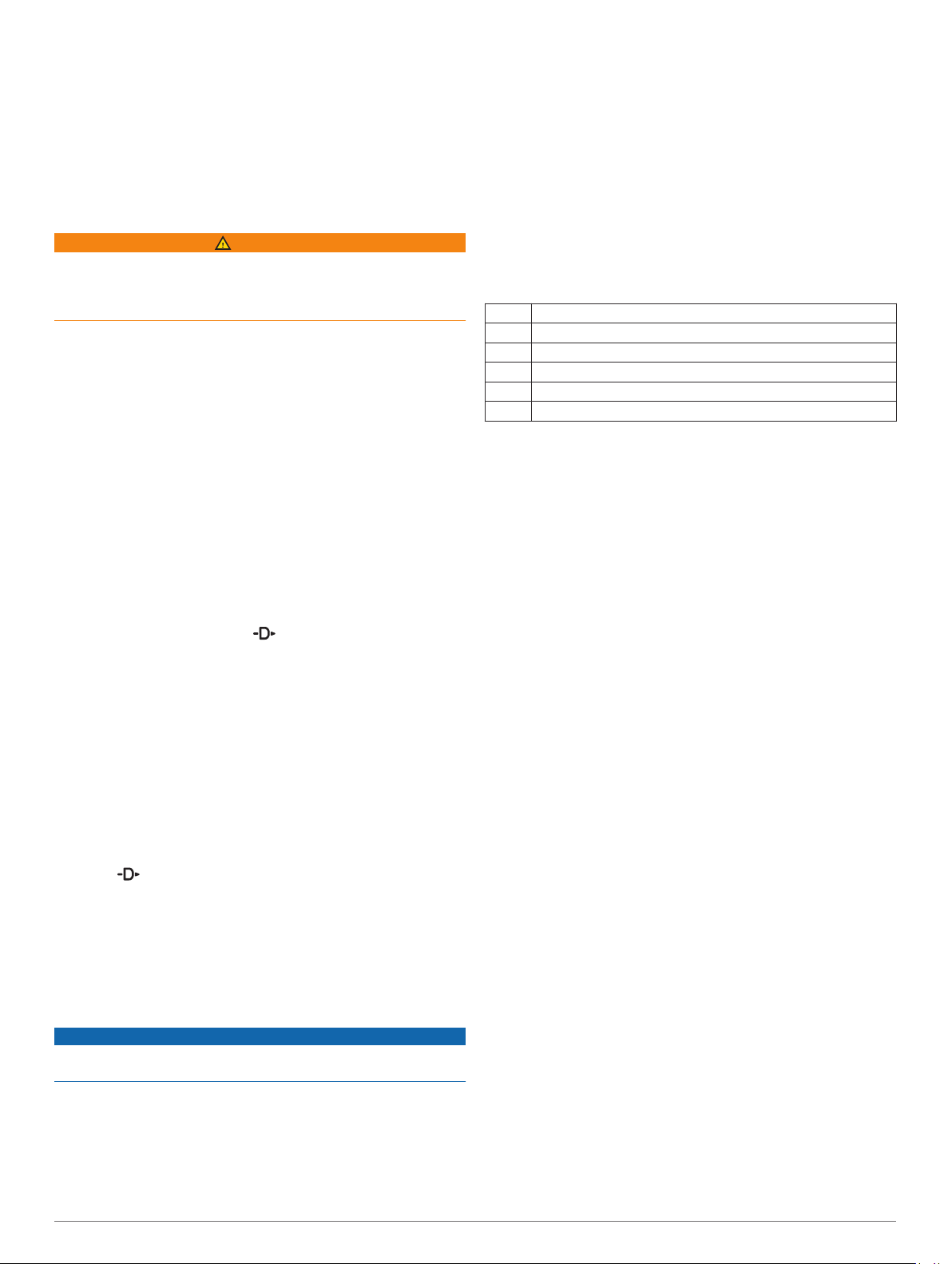
Hole Information
The device calculates the distance to the front and back of the
green, and to the selected pin location (Moving the Flag,
page 7).
Current hole number
À
Distance to the back of the green
Á
Distance to the selected pin location
Â
Distance to the front of the green
Ã
Par for the hole
Ä
Map of the green
Å
Moving the Flag
You can take a closer look at the green and move the pin
location.
From the hole information screen, select > Move Flag.
1
Select UP or DOWN to move the pin position.
2
Select .
3
The distances on the hole information screen are updated to
show the new pin location. The pin location is saved for only
the current round.
Viewing Hazards
You can view distances to hazards along the fairway for par 4
and 5 holes. Hazards that affect shot selection are displayed
individually or in groups to help you determine the distance to
layup or carry.
From the hole information screen, select > Hazards.
1
• The green is represented as a half circle à at the top of
the screen. The line below the green represents the center
of the fairway.
• Hazards Ä are shown below the green in approximate
locations relative to the fairway.
Select UP or DOWN to view other hazards for the current
2
hole.
Measuring a Shot
Take a shot, and watch where your ball lands.
1
Select > Measure Shot.
2
Walk or drive to your ball.
3
The distance automatically resets when you move to the next
hole.
If necessary, select Reset to reset the distance at any time.
4
Viewing Layup and Dogleg Distances
You can view a list of layup and dogleg distances for par 4 and 5
holes.
Select > Layups.
Each layup and the distance until you reach each layup
appear on the screen.
NOTE: Distances are removed from the list as you pass
them.
Keeping Score
From the hole information screen, select > Scorecard.
1
The scorecard appears when you are on the green.
Select UP or DOWN to scroll through the holes.
2
Select to select a hole.
3
Select UP or DOWN to set the score.
4
Your total score is updated.
Updating a Score
From the hole information screen, select > Scorecard.
1
Select UP or DOWN to scroll through the holes.
2
Select to select a hole.
3
Select UP or DOWN to change the score for that hole.
4
Your total score is updated.
TruSwing
The TruSwing feature allows you to view swing metrics recorded
from your TruSwing device. Go to www.garmin.com/golf to
purchase a TruSwing device.
™
Using the Golf Odometer
You can use the odometer to record the time, distance, and
steps traveled. The odometer automatically starts and stops
when you start or end a round.
Select > Odometer.
1
If necessary, select Reset to reset the odometer to zero.
2
Tracking Statistics
The Stat Tracking feature enables detailed statistics tracking
while playing golf.
From the hole information screen, hold MENU.
1
Select the activity settings.
2
Select Stat Tracking to enable tracking statistics.
3
Connected Features
• The distances to the front À and back Á of the nearest
hazard appear on the screen.
• The hazard type  is listed at the top of the screen.
Connected Features 7
Connected features are available for your D2 device when you
connect the device to a compatible smartphone using Bluetooth
wireless technology. Some features require you to install the
Garmin Connect Mobile app on the connected smartphone. Go
Page 14

to www.garmin.com/apps for more information. Some features
are also available when you connect your device to a wireless
network.
Phone notifications: Displays phone notifications and
messages on your D2 device.
LiveTrack: Allows friends and family to follow your races and
training activities in real time. You can invite followers using
email or social media, allowing them to view your live data on
a Garmin Connect tracking page.
GroupTrack: Allows you to keep track of your connections
using LiveTrack directly on screen and in real time.
Activity uploads to Garmin Connect: Automatically sends
your activity to your Garmin Connect account as soon as you
finish recording the activity.
Connect IQ: Allows you to extend your device features with new
watch faces, widgets, apps, and data fields.
Software Updates: Allows you to update your device software.
Weather: Allows you to view current weather conditions and
weather forecasts. You can also view weather radar on the
map.
Bluetooth sensors: Allows you to connect Bluetooth
compatible sensors, such as a heart rate monitor.
Find my phone: Locates your lost smartphone that is paired
with your D2 device and currently within range.
Find my device: Locates your lost D2 device that is paired with
your smarphone and currently within range.
Enabling Bluetooth Notifications
Before you can enable notifications, you must pair the D2 device
with a compatible mobile device (Pairing Your Smartphone with
Your Device, page 1).
Hold MENU.
1
Select Settings > Phone > Smart Notifications > Status >
2
On.
Select During Activity.
3
Select a notification preference.
4
Select a sound preference.
5
Select Not During Activity.
6
Select a notification preference.
7
Select a sound preference.
8
Select Privacy.
9
Select a privacy preference.
10
Select Timeout.
11
Select the amount of time the alert for a new notification
12
appears on the screen.
Viewing Notifications
From the watch face, select UP to view the notifications
1
widget.
Select , and select a notification.
2
Select DOWN for more options.
3
Select BACK to return to the previous screen.
4
Receiving an Incoming Phone Call
When you receive a phone call on your connected smartphone,
the D2 device displays the name or phone number of the caller.
You can accept or decline the call. If your device is connected to
a smartphone with Android™, you can also decline with a text
message by selecting from a list of messages on your D2
device.
• To accept the call, select Accept.
• To decline the call, select Decline.
• To decline the call and immediately send a text message
reply, select Reply, and select a message from the list.
Replying to a Text Message
NOTE: This feature is available only for smartphones with
Android.
When you receive a text message notification on your D2
device, you can send a quick reply by selecting from a list of
messages. You can customize messages in the Garmin
Connect Mobile app.
NOTE: This feature sends text messages using your phone.
Regular text message limits and charges from your carrier and
phone plan may apply. Contact your mobile carrier for more
information about text message charges or limits.
From the watch face, select UP to view the notifications
1
widget.
Select , and select a text message notification.
2
Select DOWN > Reply.
3
Select a message from the list.
4
Your phone sends the selected message as an SMS text
message.
Managing Notifications
You can use your compatible smartphone to manage
notifications that appear on your D2 Delta/Delta S/Delta PX
device.
Select an option:
• If you are using an Apple® smartphone, use the
notifications settings on your smartphone to select the
items to show on the device.
• If you are using a smartphone with Android, from the
Garmin Connect Mobile app, select Settings > Smart
Notifications.
Turning Off the Bluetooth Smartphone Connection
Hold LIGHT to view the controls menu.
1
Select to turn off the Bluetooth smartphone connection on
2
your D2 device.
Refer to the owner's manual for your mobile device to turn off
Bluetooth wireless technology on your mobile device.
Turning On and Off Smartphone Connection Alerts
You can set the D2 Delta/Delta S/Delta PX device to alert you
when your paired smartphone connects and disconnects using
Bluetooth wireless technology.
NOTE: Smartphone connection alerts are turned off by default.
Hold MENU.
1
Select Settings > Phone > Alerts.
2
Locating a Lost Mobile Device
You can use this feature to help locate a lost mobile device that
is paired using Bluetooth wireless technology and currently
within range.
Hold LIGHT to view the controls menu.
1
Select .
2
The D2 device begins searching for your paired mobile
device. An audible alert sounds on your mobile device, and
the Bluetooth signal strength displays on the D2 device
screen. The Bluetooth signal strength increases as you move
closer to your mobile device.
Select BACK to stop searching.
3
8 Connected Features
Page 15
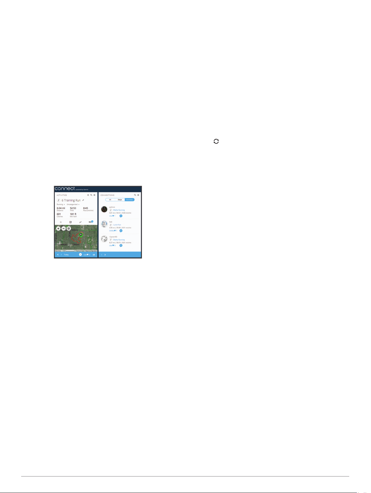
Garmin Connect
Your Garmin Connect account allows you to track your
performance and connect with your friends. It gives you the tools
to track, analyze, share, and encourage each other. You can
record the events of your active lifestyle, including runs, walks,
rides, swims, hikes, golf games, and more. It is also your online
statistics tracker, where you can analyze and share all your
rounds of golf.
You can create your free Garmin Connect account when you
pair your device with your phone using the Garmin Connect
Mobile app, or you can go to garminconnect.com.
Store your activities: After you complete and save a timed
activity with your device, you can upload that activity to your
Garmin Connect account and keep it as long as you want.
Analyze your data: You can view more detailed information
about your fitness and outdoor activities, including time,
distance, heart rate, calories burned, cadence, an overhead
map view, and pace and speed charts. You can view more
detailed information about your golf games, including
scorecards, statistics, and course information. You can also
view customizable reports.
NOTE: To view some data, you mus pair an optional wireless
sensor with your device (Pairing Your Wireless Sensors,
page 35).
Using Garmin Connect on Your Computer
The Garmin Express application connects your device to your
Garmin Connect account using a computer. You can use the
Garmin Express application to upload your activity data to your
Garmin Connect account and to send data, such as workouts or
training plans, from Garmin Connect website to your device. You
can also install device software updates and manage your
Connect IQ apps.
Connect the device to your computer using the USB cable.
1
Go to www.garmin.com/express.
2
Download and install the Garmin Express application.
3
Open the Garmin Express application, and select Add
4
Device.
Follow the on-screen instructions.
5
Manually Syncing Data with Garmin Connect Mobile
Hold LIGHT to view the controls menu.
1
Select .
2
Garmin Golf™ App
The Garmin Golf app allows golfers to compete with each other
at different courses. More than 41,000 courses have a weekly
leaderboard that anyone can join. You can set up a tournament
event and invite players to compete. You can upload scorecards
from your compatible Garmin device to view detailed statistics
and shot analyses.
The Garmin Golf app syncs your data with your Garmin Connect
account. You can download the Garmin Golf app from the app
store on your smartphone.
Track your progress: You can track your daily steps, join a
friendly competition with your connections, and meet your
goals.
Share your activities: You can connect with friends to follow
each other's activities or post links to your activities on your
favorite social networking sites.
Manage your settings: You can customize your device and
user settings on your Garmin Connect account.
Updating the Software Using Garmin Connect Mobile
Before you can update your device software using the Garmin
Connect Mobile app, you must have a Garmin Connect account,
and you must pair the device with a compatible smartphone
(Pairing Your Smartphone with Your Device, page 1).
Synchronize your device with the Garmin Connect Mobile
app (Manually Syncing Data with Garmin Connect Mobile,
page 9).
When new software is available, the Garmin Connect Mobile
app automatically sends the update to your device.
Updating the Software Using Garmin Express
Before you can update your device software, you must
download and install the Garmin Express application and add
your device (Using Garmin Connect on Your Computer,
page 9).
Connect the device to your computer using the USB cable.
1
When new software is available, the Garmin Express
application sends it to your device.
After the Garmin Express application finishes sending the
2
update, disconnect the device from your computer.
Your device installs the update.
Starting a GroupTrack Session
Before you can start a GroupTrack session, you must have a
Garmin Connect account, a compatible smartphone, and the
Garmin Connect Mobile app.
These instructions are for starting a GroupTrack session with D2
Delta/Delta S/Delta PX devices. If your connections have other
compatible devices, you can see them on the map. The other
devices may not be able to display GroupTrack riders on the
map.
Go outside, and turn on the D2 Delta/Delta S/Delta PX
1
device.
Pair your smartphone with the D2 Delta/Delta S/Delta PX
2
device (Pairing Your Smartphone with Your Device, page 1).
On the D2 Delta/Delta S/Delta PX device, hold MENU, and
3
select Settings > GroupTrack > Show on Map to enable
viewing connections on the map screen.
In the Garmin Connect Mobile app, from the settings menu,
4
select LiveTrack > GroupTrack.
If you have more than one compatible device, select a device
5
for the GroupTrack session.
Select Visible to > All Connections.
6
Select Start LiveTrack.
7
On the D2 Delta/Delta S/Delta PX device, start an activity.
8
Scroll to the map to view your connections.
9
TIP: From the map, you can hold MENU and select Nearby
Connections to view distance, direction, and pace or speed
information for other connections in the GroupTrack session.
Tips for GroupTrack Sessions
The GroupTrack feature allows you to keep track of other
connections in your group using LiveTrack directly on the
screen. All members of the group must be your connections in
your Garmin Connect account.
• Ride outside using GPS.
• Pair your D2 Delta/Delta S/Delta PX device with your
smartphone using Bluetooth technology.
Connected Features 9
Page 16

• In the Garmin Connect Mobile app, from the settings menu,
select Connections to update the list of connections for your
GroupTrack session.
• Make sure all of your connections pair to their smartphones
and start a LiveTrack session in the Garmin Connect Mobile
app.
• Make sure all your connections are in range (40 km or
25 mi.).
• During a GroupTrack session, scroll to the map to view your
connections (Adding a Map to an Activity, page 28).
Garmin Explore
The Garmin Explore website allows you to plan trips and use
cloud storage for your waypoints, routes, and tracks. It offers
advanced planning, allowing you to share and sync data with
your compatible Garmin device.
You can go to explore.garmin.com.
™
Connext
Connext devices deliver a connected cockpit solution. You can
wirelessly upload databases and flight plans from your mobile
device to your Connext device, and pair your device with your
watch to view aircraft information at a glance.
Garmin Pilot app: The Garmin Pilot app allows you to create
flight plans and send them to your watch (Connecting to the
Garmin Pilot App, page 10).
Connext devices: You can pair your watch with compatible
Connext devices, such as a Flight Stream 510 device, to
display data from your avionics on your watch. For example,
weather, GPS position data, and backup altitude information
(Pairing a Connext Device, page 10).
Connecting to the Garmin Pilot App
You can use the Garmin Pilot app to create flight plans and send
them to your D2 device. The Garmin Pilot app is available for
some mobile devices. See the app store for your mobile device
for availability and compatibility information.
Your D2 device connects to the Garmin Pilot app using
Bluetooth technology. Go to www.garmin.com/ble for
compatibility information.
Pair your smartphone with your D2 device (Pairing Your
1
Smartphone with Your Device, page 1).
From the app store on your smartphone, install and open the
2
Garmin Pilot app.
The Garmin Pilot app detects your device and connects to it
automatically.
Pairing a Connext Device
The first time you connect your D2 watch to a compatible
Connext device, you must pair them using Bluetooth technology.
Enter pairing mode on your Connext device.
1
Bring your watch within 10 m (33 ft.) of your device.
2
Hold MENU.
3
Select Settings > Aviation > Connext > Pair Connext >
4
Status > On.
A prompt appears on your Connext device. After the watch is
paired with your device, a message appears on your watch.
Aircraft information from the Connext device appears in the
data screen loop or custom data fields.
Select Start with FLY (optional).
5
Your Connext device connects automatically when you start
a flying activity on the watch, and the device is active and
within range.
Wi‑Fi Connected Features
The D2 Delta/Delta S/Delta PX device has Wi‑Fi connected
features. The Garmin Connect Mobile app is not required for you
to use Wi‑Fi connectivity.
Activity uploads to your Garmin Connect account:
Automatically sends your activity to your Garmin Connect
account as soon as you finish recording the activity.
Workouts and training plans: Allows you to browse for and
select workouts and training plans on the Garmin Connect
site. The next time your device has a Wi‑Fi connection, the
files are wirelessly sent to your device.
Software updates: Your device downloads and installs the
latest software update automatically when a Wi‑Fi connection
is available.
Setting Up Wi‑Fi Connectivity
Select an option:
1
• Download the Garmin Connect Mobile app, and pair your
smartphone (Pairing Your Smartphone with Your Device,
page 1).
• Go to www.garmin.com/express, and download the
Garmin Express application.
Follow the on-screen instructions to set up Wi‑Fi connectivity.
2
Connect IQ Features
You can add Connect IQ features to your watch from Garmin
and other providers using the Connect IQ Mobile app. You can
customize your device with watch faces, data fields, widgets,
and apps.
Watch Faces: Allow you to customize the appearance of the
clock.
Data Fields: Allow you to download new data fields that present
sensor, activity, and history data in new ways. You can add
Connect IQ data fields to built-in features and pages.
Widgets: Provide information at a glance, including sensor data
and notifications.
Apps: Add interactive features to your watch, such as new
outdoor and fitness activity types.
Downloading Connect IQ Features
Before you can download features from the Connect IQ Mobile
app, you must pair your D2 Delta/Delta S/Delta PX device with
your smartphone.
From the app store on your smartphone, install and open the
1
Connect IQ Mobile app.
If necessary, select your device.
2
Select a Connect IQ feature.
3
Follow the on-screen instructions.
4
Downloading Connect IQ Features Using Your Computer
Connect the device to your computer using a USB cable.
1
Go to apps.garmin.com, and sign in.
2
Select a Connect IQ feature, and download it.
3
Follow the on-screen instructions.
4
Garmin Pay
The Garmin Pay feature allows you to use your watch to pay for
purchases in participating stores using credit or debit cards from
a participating financial institution.
10 Wi‑Fi Connected Features
Page 17

Setting Up Your Garmin Pay Wallet
You can add one or more participating credit or debit cards to
your Garmin Pay wallet. Go to garmin.com/garminpay/banks to
find participating financial institutions.
From the Garmin Connect Mobile app, select or .
1
Select Garmin Devices, and select your device.
2
Select Garmin Pay > Create Your Wallet.
3
Follow the on-screen instructions.
4
Paying for a Purchase Using Your Watch
Before you can use your watch to pay for purchases, you must
set up at least one payment card.
You can use your watch to pay for purchases in a participating
store.
Hold LIGHT.
1
Select .
2
Enter your four-digit passcode.
3
NOTE: If you enter your passcode incorrectly three times,
your wallet locks, and you must reset your passcode in the
Garmin Connect Mobile app.
Your most recently used payment card appears.
If you have added multiple cards to your Garmin Pay wallet,
4
select DOWN to change to another card (optional).
Within 60 seconds, hold your watch near the payment reader,
5
with the watch facing the reader.
The watch vibrates and displays a check mark when it is
finished communicating with the reader.
If necessary, follow the instructions on the card reader to
6
complete the transaction.
TIP: After you successfully enter your passcode, you can make
payments without a passcode for 24 hours while you continue to
wear your watch. If you remove the watch from your wrist or
disable heart rate monitoring, you must enter the passcode
again before making a payment.
Adding a Card to Your Garmin Pay Wallet
You can add up to ten credit or debit cards to your Garmin Pay
wallet.
From the D2 Delta/Delta S/Delta PX device page in the
1
Garmin Connect Mobile app, select Garmin Pay > .
Follow the on-screen instructions to enter the card
2
information and add the card to your wallet.
After the card is added, you can select the card on your watch
when you make a payment.
Managing Your Garmin Pay Wallet
You can view detailed information about each of your payment
cards, and you can suspend, activate, or delete a card. You can
also suspend or delete your whole Garmin Pay wallet.
NOTE: In some countries, participating financial institutions may
restrict the wallet features.
From the D2 Delta/Delta S/Delta PX device page in the
1
Garmin Connect Mobile app, select Garmin Pay > Manage
Your Wallet.
Select an option:
2
• To suspend a specific card, select the card, and select
Suspend.
The card must be active to make purchases using your D2
Delta/Delta S/Delta PX device.
• To temporarily suspend all cards in your wallet, select
Suspend Wallet.
You cannot pay using your D2 Delta/Delta S/Delta PX
device until you unsuspend at least one card using the
app.
• To unsuspend your suspended wallet, select Unsuspend
Wallet.
• To delete a specific card, select the card, and select
Delete.
The card is completely deleted from your wallet. If you
want to add this card to your wallet in the future, you must
enter the card information again.
• To delete all cards in your wallet, select Delete Wallet.
Your Garmin Pay wallet and all the card information
associated with it are deleted. You cannot pay using your
D2 Delta/Delta S/Delta PX device until you create a new
wallet and add a card.
Changing Your Garmin Pay Passcode
You must know your current passcode to change it. Your
passcode cannot be recovered. If you forget your passcode, you
must delete your wallet, create a new one, and reenter your card
information.
You can change the passcode required to access your
Garmin Pay wallet on your D2 Delta/Delta S/Delta PX device.
From the D2 Delta/Delta S/Delta PX device page in the
1
Garmin Connect Mobile app, select Garmin Pay > Reset
Passcode.
Follow the on-screen instructions.
2
The next time you pay using your D2 Delta/Delta S/Delta PX
device, you must enter the new passcode.
Music
You can download audio content to your device from your
computer or from a third-party provider, so you can listen when
your smartphone is not nearby. To listen to audio content stored
on your device, you must connect headphones with Bluetooth
technology.
You can use the music controls to control music playback on
your smartphone or to play music stored on your device.
Connecting to a Third-Party Provider
Before you can download music or other audio files to your
compatible watch from a supported third-party provider, you
must connect to the provider using the Garmin Connect Mobile
app.
From the Garmin Connect Mobile app, select or .
1
Select Garmin Devices, and select your device.
2
Select Music.
3
Select an option:
4
• Select a third-party provider, and follow the on-screen
instructions.
• Select Get Music Apps, locate a provider, and follow the
on-screen instructions.
Music 11
Page 18

Downloading Audio Content from a Third-Party Provider
Before you can download audio content from a third-party
provider, you must connect to a Wi‑Fi network (Setting Up Wi‑Fi
Connectivity, page 10).
Hold DOWN from any screen to open the music controls.
1
Select > Music Providers.
2
Select a connected provider.
3
Select a playlist or other item to download to the device.
4
Select BACK until you are prompted to sync with the service,
5
and select Yes.
The selected playlists and other items are downloaded to the
device.
Connect the device to an external power source.
6
Downloading audio content can drain the battery.
Disconnecting from a Third-Party Provider
From the Garmin Connect Mobile app, select or .
1
Select Garmin Devices, and select your device.
2
Select Music.
3
Select an installed third-party provider, and follow the on-
4
screen instructions to disconnect the third-party provider from
your device.
Downloading Personal Audio Content
Before you can send your personal music to your device, you
must install the Garmin Express application on your computer
(www.garmin.com/express).
You can load your personal audio files, such as .mp3 and .aac
files, to a D2 device from your computer.
Connect the device to your computer using the included USB
1
cable.
On your computer, open the Garmin Express application,
2
select your device, and select Music.
TIP: For Windows® computers, you can select and browse
to the folder with your audio files. For Apple computers, the
Garmin Express application uses your iTunes® library.
In the My Music or iTunes Library list, select an audio file
3
category, such as songs or playlists.
Select the checkboxes for the audio files, and select Send to
4
Device.
If necessary, in the D2 list, select a category, select the
5
checkboxes, and select Remove From Device to remove
audio files.
Listening to Music
Hold DOWN from any screen to open the music controls.
1
Connect your headphones with Bluetooth technology
2
(Connecting Headphones using Bluetooth Technology,
page 12).
Select , and select an option:
3
• To listen to music downloaded to the watch from your
computer, select My Music (Downloading Personal Audio
Content, page 12).
• To listen to music from your smartphone, select Control
Music on Phone.
• To listen to music from a third-party provider, select the
name of the provider.
Select the music you want to play.
4
TIP: Select Play All Songs to start playing all the songs
downloaded to the device in shuffle mode.
Music Playback Controls
Select to manage content from third-party providers.
Select to switch between playing audio from the device and
controlling music on a connected smartphone.
When playing audio from the device, select to browse the
available audio files and playlists in your library.
Select to adjust the volume.
Select to play and pause the current audio file.
Select to skip to the next audio file in the playlist.
Hold to fast forward through the current audio file.
Select to restart the current audio file.
Select twice to skip to the previous audio file in the playlist.
Hold to rewind through the current audio file.
Select to change the repeat mode.
Select to change the shuffle mode.
Connecting Headphones using Bluetooth Technology
To listen to music loaded onto your D2 device, you must
connect headphones using Bluetooth technology.
Bring the headphones within 2 m (6.6 ft.) of your device.
1
Enable pairing mode on the headphones.
2
Hold MENU.
3
Select Settings > Sensors & Accessories > Add New >
4
Headphones.
Select your headphones to complete the pairing process.
5
Heart Rate Features
The D2 Delta/Delta S/Delta PX device has a wrist-based heart
rate monitor and is also compatible with chest heart rate
monitors (sold separately). You can view heart rate data on the
heart rate widget. If both wrist-based heart rate and chest heart
rate data are available, your device uses the chest heart rate
data.
Wrist-based Heart Rate
Wearing the Device
• Wear the device above your wrist bone.
NOTE: The device should be snug but comfortable. For more
accurate heart rate readings on the D2 Delta/Delta S/Delta
PX device, it should not move while running or exercising.
For more accurate pulse oximeter readings on the D2 Delta
PX device, you should remain motionless.
12 Heart Rate Features
Page 19

NOTE: The optical sensor is located on the back of the
device.
• See Tips for Erratic Heart Rate Data, page 13 for more
information about wrist-based heart rate.
• See Tips for Erratic Pulse Oximeter Data, page 19 for more
information about the pulse oximeter sensor.
• For more information about accuracy, go to garmin.com
/ataccuracy.
Tips for Erratic Heart Rate Data
If the heart rate data is erratic or does not appear, you can try
these tips.
• Clean and dry your arm before putting on the device.
• Avoid wearing sunscreen, lotion, and insect repellent under
the device.
• Avoid scratching the heart rate sensor on the back of the
device.
• Wear the device above your wrist bone. The device should
be snug but comfortable.
• Wait until the icon is solid before starting your activity.
• Warm up for 5 to 10 minutes and get a heart rate reading
before starting your activity.
NOTE: In cold environments, warm up indoors.
• Rinse the device with fresh water after each workout.
• While exercising, use a silicone band.
Viewing the Heart Rate Widget
The widget displays your current heart rate in beats per minute
(bpm) and a graph of your heart rate for the last 4 hours.
From the watch face, select DOWN.
1
Select to view your average resting heart rate values for
2
the last 7 days.
NOTE: Broadcasting heart rate data decreases battery life.
From the heart rate widget, hold MENU.
1
Select Options > Broadcast During Activity.
2
Begin an activity (Starting an Activity, page 4).
3
The D2 Delta/Delta S/Delta PX device starts broadcasting
your heart rate data in the background.
NOTE: There is no indication that the device is broadcasting
your heart rate data during an activity.
If necessary, pair your D2 Delta/Delta S/Delta PX device with
4
your Garmin ANT+ compatible device.
NOTE: The pairing instructions differ for each Garmin
compatible device. See your owner's manual.
TIP: To stop broadcasting your heart rate data, stop the
activity (Stopping an Activity, page 4).
Turning Off the Wrist-based Heart Rate Monitor
The default value for the Wrist Heart Rate setting is Auto. The
device automatically uses the wrist-based heart rate monitor
unless you pair an ANT+ heart rate monitor to the device.
NOTE: Disabling the wrist-based heart rate monitor also
disables the on-wrist detection feature for Garmin Pay
payments, and you must enter a passcode before making each
payment (Garmin Pay, page 10).
NOTE: Disabling the wrist-based heart rate monitor also
disables the wrist-based pulse oximeter sensor.
From the heart rate widget, hold MENU.
1
Select Options > Status > Off.
2
Putting On the Heart Rate Monitor
You should wear the heart rate monitor directly on your skin, just
below your sternum. It should be snug enough to stay in place
during your activity.
If necessary, attach the strap extender to the heart rate
1
monitor.
Wet the electrodes À on the back of the heart rate monitor to
2
create a strong connection between your chest and the
transmitter.
Broadcasting Heart Rate Data to Garmin Devices
Wear the heart rate monitor with the Garmin logo facing right-
You can broadcast your heart rate data from your D2 Delta/
Delta S/Delta PX device and view it on paired Garmin devices.
NOTE: Broadcasting heart rate data decreases battery life.
From the heart rate widget, hold MENU.
1
Select Options > Broadcast Heart Rate.
2
The D2 Delta/Delta S/Delta PX device starts broadcasting
your heart rate data, and appears.
NOTE: You can view only the heart rate widget while
broadcasting heart rate data from the heart rate widget.
Pair your D2 Delta/Delta S/Delta PX device with your Garmin
3
ANT+ compatible device.
NOTE: The pairing instructions differ for each Garmin
compatible device. See your owner's manual.
TIP: To stop broadcasting your heart rate data, select any
key, and select Yes.
Broadcasting Heart Rate Data During an Activity
You can set up your D2 Delta/Delta S/Delta PX device to
broadcast your heart rate data automatically when you begin an
activity. For example, you can broadcast your heart rate data to
an Edge® device while cycling, or to a VIRB® action camera
during an activity.
Heart Rate Features 13
3
side up.
The loop Á and hook  connection should be on your right
side.
Wrap the heart rate monitor around your chest, and connect
4
the strap hook to the loop.
NOTE: Make sure the care tag does not fold over.
After you put on the heart rate monitor, it is active and sending
data.
Tips for Erratic Heart Rate Data
If the heart rate data is erratic or does not appear, you can try
these tips.
Page 20

• Reapply water to the electrodes and contact patches (if
applicable).
• Tighten the strap on your chest.
• Warm up for 5 to 10 minutes.
• Follow the care instructions (Caring for the Heart Rate
Monitor, page 14).
• Wear a cotton shirt or thoroughly wet both sides of the strap.
Synthetic fabrics that rub or flap against the heart rate
monitor can create static electricity that interferes with heart
rate signals.
• Move away from sources that can interfere with your heart
rate monitor.
Sources of interference may include strong electromagnetic
fields, some 2.4 GHz wireless sensors, high-voltage power
lines, electric motors, ovens, microwave ovens, 2.4 GHz
cordless phones, and wireless LAN access points.
Caring for the Heart Rate Monitor
NOTICE
A buildup of sweat and salt on the strap can decrease the ability
of the heart rate monitor to report accurate data.
• Rinse the heart rate monitor after every use.
• Hand wash the heart rate monitor after every seven uses or
one pool swim, using a tiny amount of mild detergent, such
as dishwashing liquid.
NOTE: Using too much detergent may damage the heart rate
monitor.
• Do not put the heart rate monitor in a washing machine or
dryer.
• When drying the heart rate monitor, hang it up or lay it flat.
Running Dynamics
You can use your compatible D2 device paired with the
HRM-Run™ accessory or other running dynamics accessory to
provide real-time feedback about your running form. If your D2
device was packaged with the HRM-Run accessory, the devices
are already paired.
The running dynamics accessory has an accelerometer that
measures torso movement in order to calculate six running
metrics.
Cadence: Cadence is the number of steps per minute. It
displays the total steps (right and left combined).
Vertical oscillation: Vertical oscillation is your bounce while
running. It displays the vertical motion of your torso,
measured in centimeters.
Ground contact time: Ground contact time is the amount of
time in each step that you spend on the ground while
running. It is measured in milliseconds.
NOTE: Ground contact time and balance are not available
while walking.
Ground contact time balance: Ground contact time balance
displays the left/right balance of your ground contact time
while running. It displays a percentage. For example, 53.2
with an arrow pointing left or right.
Stride length: Stride length is the length of your stride from one
footfall to the next. It is measured in meters.
Vertical ratio: Vertical ratio is the ratio of vertical oscillation to
stride length. It displays a percentage. A lower number
typically indicates better running form.
Training with Running Dynamics
Before you can view running dynamics, you must put on a
running dynamics accessory, such as the HRM-Run accessory,
and pair it with your device (Pairing Your Wireless Sensors,
page 35). If your D2 Delta/Delta S/Delta PX was packaged with
the accessory, the devices are already paired, and the D2 Delta/
Delta S/Delta PX is set to display running dynamics data
screens.
Select an option:
1
• If your running dynamics accessory and D2 Delta/Delta S/
Delta PX device are already paired, skip to step 7.
• If your running dynamics accessory and D2 Delta/Delta S/
Delta PX device are not already paired, complete all the
steps in this procedure.
Hold MENU.
2
Select Settings > Activities & Apps.
3
Select an activity.
4
Select the activity settings.
5
Select Data Screens > Add New.
6
Select a running dynamics data screen.
7
NOTE: The running dynamics screens are not available for
all activities.
Go for a run (Starting an Activity, page 4).
8
Select UP or DOWN to open a running dynamics screen to
9
view your metrics.
Color Gauges and Running Dynamics Data
The running dynamics screens display a color gauge for the primary metric. You can display cadence, vertical oscillation, ground
contact time, ground contact time balance, or vertical ratio as the primary metric. The color gauge shows you how your running
dynamics data compare to those of other runners. The color zones are based on percentiles.
Garmin has researched many runners of all different levels. The data values in the red or orange zones are typical for less
experienced or slower runners. The data values in the green, blue, or purple zones are typical for more experienced or faster
runners. More experienced runners tend to exhibit shorter ground contact times, lower vertical oscillation, lower vertical ratio, and
higher cadence than less experienced runners. However, taller runners typically have slightly slower cadences, longer strides, and
slightly higher vertical oscillation. Vertical ratio is your vertical oscillation divided by stride length. It is not correlated with height.
Go to www.garmin.com/runningdynamics for more information on running dynamics. For additional theories and interpretations of
running dynamics data, you can search reputable running publications and websites.
Color Zone Percentile in Zone Cadence Range Ground Contact Time Range
Purple >95 >183 spm <218 ms
Blue 70–95 174–183 spm 218–248 ms
Green 30–69 164–173 spm 249–277 ms
14 Heart Rate Features
Page 21

Color Zone Percentile in Zone Cadence Range Ground Contact Time Range
Orange 5–29 153–163 spm 278–308 ms
Red <5 <153 spm >308 ms
Ground Contact Time Balance Data
Ground contact time balance measures your running symmetry and appears as a percentage of your total ground contact time. For
example, 51.3% with an arrow pointing left indicates the runner is spending more time on the ground when on the left foot. If your
data screen displays both numbers, for example 48–52, 48% is the left foot and 52% is the right foot.
Color Zone Red Orange Green Orange Red
Symmetry Poor Fair Good Fair Poor
Percent of Other Runners 5% 25% 40% 25% 5%
Ground Contact Time Balance >52.2% L 50.8–52.2% L 50.7% L–50.7% R 50.8–52.2% R >52.2% R
While developing and testing running dynamics, the Garmin team found correlations between injuries and greater imbalances with
certain runners. For many runners, ground contact time balance tends to deviate further from 50–50 when running up or down hills.
Most running coaches agree that a symmetrical running form is good. Elite runners tend to have quick and balanced strides.
You can watch the color gauge or data field during your run or view the summary on your Garmin Connect account after your run.
As with the other running dynamics data, ground contact time balance is a quantitative measurement to help you learn about your
running form.
Vertical Oscillation and Vertical Ratio Data
The data ranges for vertical oscillation and vertical ratio are slightly different depending on the sensor and whether it is positioned at
the chest (HRM-Tri™ or HRM-Run accessories) or at the waist (Running Dynamics Pod accessory).
Color Zone Percentile in Zone Vertical Oscillation Range at
Chest
Purple >95 <6.4 cm <6.8 cm <6.1% <6.5%
Blue 70–95 6.4–8.1 cm 6.8–8.9 cm 6.1–7.4% 6.5–8.3%
Green 30–69 8.2–9.7 cm 9.0–10.9 cm 7.5–8.6% 8.4–10.0%
Orange 5–29 9.8–11.5 cm 11.0–13.0 cm 8.7–10.1% 10.1–11.9%
Red <5 >11.5 cm >13.0 cm >10.1% >11.9%
Vertical Oscillation Range at
Waist
Vertical Ratio at Chest Vertical Ratio at Waist
Tips for Missing Running Dynamics Data
If running dynamics data does not appear, you can try these
tips.
• Make sure you have a running dynamics accessory, such as
the HRM-Run accessory.
Accessories with running dynamics have on the front of the
module.
• Pair the running dynamics accessory with your D2 device
again, according to the instructions.
• If the running dynamics data display shows only zeros, make
sure the accessory is worn right-side up.
NOTE: Ground contact time and balance appears only while
running. It is not calculated while walking.
Performance Measurements
These performance measurements are estimates that can help
you track and understand your training activities and race
performances. The measurements require a few activities using
wrist-based heart rate or a compatible chest heart rate monitor.
Cycling performance measurements require a heart rate monitor
and a power meter.
These estimates are provided and supported by Firstbeat. For
more information, go to www.garmin.com/physio.
NOTE: The estimates may seem inaccurate at first. The device
requires you to complete a few activities to learn about your
performance.
Training status: Training status shows you how your training
affects your fitness and performance. Your training status is
based on changes to your training load and VO2 max. over
an extended time period.
VO2 max.: VO2 max. is the maximum volume of oxygen (in
milliliters) you can consume per minute per kilogram of body
weight at your maximum performance.
Recovery time: The recovery time displays how much time
remains before you are fully recovered and ready for the next
hard workout.
Training load: Training load is the sum of your excess post-
exercise oxygen consumption (EPOC) over the last 7 days.
EPOC is an estimate of how much energy it takes for your
body to recover after exercise.
Predicted race times: Your device uses the VO2 max. estimate
and published data sources to provide a target race time
based on your current state of fitness. This projection also
presumes you have completed the proper training for the
race.
HRV stress test: The HRV (heart rate variability) stress test
requires a Garmin chest heart rate monitor. The device
records your heart rate variability while standing still for 3
minutes. It provides your overall stress level. The scale is 1 to
100, and a lower score indicates a lower stress level.
Performance condition: Your performance condition is a real-
time assessment after 6 to 20 minutes of activity. It can be
added as a data field so you can view your performance
condition during the rest of your activity. It compares your
real-time condition to your average fitness level.
Heart Rate Features 15
Page 22

Functional threshold power (FTP): The device uses your user
profile information from the initial setup to estimate your FTP.
For a more accurate rating, you can conduct a guided test.
Lactate threshold: Lactate threshold requires a chest heart rate
monitor. Lactate threshold is the point where your muscles
start to rapidly fatigue. Your device measures your lactate
threshold level using heart rate data and pace.
Turning Off Performance Notifications
Performance notifications are turned on by default. Some
performance notifications are alerts that appear upon completion
of your activity. Some performance notifications appear during
an activity or when you achieve a new performance
measurement, such as a new VO2 max. estimate.
Hold MENU.
1
Select Settings > Physiological Metrics > Performance
2
Notifications.
Select an option.
3
Detecting Performance Measurements Automatically
The Auto Detection feature is turned on by default. The device
can automatically detect your maximum heart rate, and lactate
threshold during an activity. When paired with a compatible
power meter, the device can automatically detect your functional
threshold power (FTP) during an activity.
NOTE: The device detects a maximum heart rate only when
your heart rate is higher than the value set in your user profile.
Hold MENU.
1
Select Settings > Physiological Metrics > Auto Detection.
2
Select an option.
3
Training Status
Training status shows you how your training affects your fitness
level and performance. Your training status is based on changes
to your training load and VO2 max. over an extended time
period. You can use your training status to help plan future
training and continue improving your fitness level.
Peaking: Peaking means that you are in ideal race condition.
Your recently reduced training load is allowing your body to
recover and fully compensate for earlier training. You should
plan ahead, since this peak state can only be maintained for
a short time.
Productive: Your current training load is moving your fitness
level and performance in the right direction. You should plan
recovery periods into your training to maintain your fitness
level.
Maintaining: Your current training load is enough to maintain
your fitness level. To see improvement, try adding more
variety to your workouts or increasing your training volume.
Recovery: Your lighter training load is allowing your body to
recover, which is essential during extended periods of hard
training. You can return to a higher training load when you
feel ready.
Unproductive: Your training load is at a good level, but your
fitness is decreasing. Your body may be struggling to
recover, so you should pay attention to your overall health
including stress, nutrition, and rest.
Detraining: Detraining occurs when you are training much less
than usual for a week or more, and it is affecting your fitness
level. You can try increasing your training load to see
improvement.
Overreaching: Your training load is very high and
counterproductive. Your body needs a rest. You should give
yourself time to recover by adding lighter training to your
schedule.
No Status: The device needs one or two weeks of training
history, including activities with VO2 max. results from
running or cycling, to determine your training status.
Tips for Getting Your Training Status
To get the most out of the training status feature, you can try
these tips.
• Run outdoors with heart rate at least two times per week, or
ride with heart rate and power at least two times per week.
After using the device for one week, your training status
should be available.
• Record all of your fitness activities on this device, allowing it
to learn about your performance.
About VO2 Max. Estimates
VO2 max. is the maximum volume of oxygen (in milliliters) you
can consume per minute per kilogram of body weight at your
maximum performance. In simple terms, VO2 max. is an
indication of athletic performance and should increase as your
level of fitness improves. The D2 Delta/Delta S/Delta PX device
requires wrist-based heart rate or a compatible chest heart rate
monitor to display your VO2 max. estimate. The device has
separate VO2 max. estimates for running and cycling. You must
run either outside with GPS or ride with a compatible power
meter at a moderate level of intensity for several minutes to get
an accurate VO2 max. estimate.
On the device, your VO2 max. estimate appears as a number,
description, and position on the color gauge. On your Garmin
Connect account, you can view additional details about your
VO2 max. estimate, including your fitness age. Your fitness age
gives you an idea of how your fitness compares with a person of
the same gender and different age. As you exercise, your fitness
age can decrease over time.
Purple Superior
Blue Excellent
Green Good
Orange Fair
Red Poor
VO2 max. data is provided by FirstBeat. VO2 max. analysis is
provided with permission from The Cooper Institute®. For more
information, see the appendix (VO2 Max. Standard Ratings,
page 42), and go to www.CooperInstitute.org.
Getting Your VO2 Max. Estimate for Running
This feature requires wrist-based heart rate or a compatible
chest heart rate monitor. If you are using a chest heart rate
monitor, you must put it on and pair it with your device (Pairing
Your Wireless Sensors, page 35). If your D2 Delta/Delta S/
Delta PX device was packaged with a heart rate monitor, the
devices are already paired.
For the most accurate estimate, complete the user profile setup
(Setting Up Your User Profile, page 19), and set your
maximum heart rate (Setting Your Heart Rate Zones, page 20).
The estimate may seem inaccurate at first. The device requires
a few runs to learn about your running performance.
Run for at least 10 minutes outdoors.
1
After your run, select Save.
2
Select UP or DOWN to view the performance widget.
3
16 Heart Rate Features
Page 23

Select to scroll through the performance measurements.
4
Getting Your VO2 Max. Estimate for Cycling
This feature requires a power meter and wrist-based heart rate
or a compatible chest heart rate monitor. The power meter must
be paired with your D2 Delta/Delta S/Delta PX device (Pairing
Your Wireless Sensors, page 35). If you are using a chest
heart rate monitor, you must put it on and pair it with your
device. If your D2 Delta/Delta S/Delta PX device was packaged
with a heart rate monitor, the devices are already paired.
For the most accurate estimate, complete the user profile setup
(Setting Up Your User Profile, page 19) and set your maximum
heart rate (Setting Your Heart Rate Zones, page 20). The
estimate may seem inaccurate at first. The device requires a few
rides to learn about your cycling performance.
Ride at a steady, high intensity for at least 20 minutes.
1
After your ride, select Save.
2
Select UP or DOWN to view the performance widget.
3
Select to scroll through the performance measurements.
4
Recovery Time
You can use your Garmin device with wrist-based heart rate or a
compatible chest heart rate monitor to display how much time
remains before you are fully recovered and ready for the next
hard workout.
NOTE: The recovery time recommendation uses your VO2 max.
estimate and may seem inaccurate at first. The device requires
you to complete a few activities to learn about your
performance.
The recovery time appears immediately following an activity.
The time counts down until it is optimal for you to attempt
another hard workout.
Viewing Your Recovery Time
For the most accurate estimate, complete the user profile setup
(Setting Up Your User Profile, page 19), and set your
maximum heart rate (Setting Your Heart Rate Zones, page 20).
Go for a run.
1
After your run, select Save.
2
The recovery time appears. The maximum time is 4 days.
NOTE: From the watch face, you can select UP or DOWN to
view the performance widget, and select to scroll through
the performance measurements to view your recovery time.
Recovery Heart Rate
If you are training with wrist-based heart rate or a compatible
chest heart rate monitor, you can check your recovery heart rate
value after each activity. Recovery heart rate is the difference
between your exercising heart rate and your heart rate two
minutes after the exercise has stopped. For example, after a
typical training run, you stop the timer. Your heart rate is
140 bpm. After two minutes of no activity or cool down, your
heart rate is 90 bpm. Your recovery heart rate is 50 bpm (140
minus 90). Some studies have linked recovery heart rate to
cardiac health. Higher numbers generally indicate healthier
hearts.
TIP: For best results, you should stop moving for two minutes
while the device calculates your recovery heart rate value. You
can save or discard the activity after this value appears.
Training Load
Training load is a measurement of your training volume over the
last seven days. It is the sum of your excess post-exercise
oxygen consumption (EPOC) measurements for the last seven
days. The gauge indicates whether your current load is low,
high, or within the optimal range to maintain or improve your
fitness level. The optimal range is determined based on your
individual fitness level and training history. The range adjusts as
your training time and intensity increase or decrease.
Viewing Your Predicted Race Times
For the most accurate estimate, complete the user profile setup
(Setting Up Your User Profile, page 19), and set your
maximum heart rate (Setting Your Heart Rate Zones, page 20).
Your device uses the VO2 max. estimate (About VO2 Max.
Estimates, page 16) and published data sources to provide a
target race time based on your current state of fitness. This
projection also presumes you have completed the proper
training for the race.
NOTE: The projections may seem inaccurate at first. The device
requires a few runs to learn about your running performance.
Select UP or DOWN to view the performance widget.
1
Select to scroll through the performance measurements.
2
Your projected race times appear for 5K, 10K, half marathon,
and marathon distances.
About Training Effect
Training Effect measures the impact of an activity on your
aerobic and anaerobic fitness. Training Effect accumulates
during the activity. As the activity progresses, the Training Effect
value increases, telling you how the activity has improved your
fitness. Training Effect is determined by your user profile
information, heart rate, duration, and intensity of your activity.
Aerobic Training Effect uses your heart rate to measure how the
accumulated intensity of an exercise affects your aerobic fitness
and indicates if the workout had a maintaining or improving
effect on your fitness level. Your EPOC accumulated during
exercise is mapped to a range of values that account for your
fitness level and training habits. Steady workouts at moderate
effort or workouts involving longer intervals (>180 sec) have a
positive impact on your aerobic metabolism and result in an
improved aerobic Training Effect.
Anaerobic Training Effect uses heart rate and speed (or power)
to determine how a workout affects your ability to perform at
very high intensity. You receive a value based on the anaerobic
contribution to EPOC and the type of activity. Repeated highintensity intervals of 10 to 120 seconds have a highly beneficial
impact on your anaerobic capability and result in an improved
anaerobic Training Effect.
It is important to know that your Training Effect numbers (from
0.0 to 5.0) may seem abnormally high during your first few
activities. It takes several activities for the device to learn your
aerobic and anaerobic fitness.
You can add Training Effect as a data field to one of your
training screens to monitor your numbers throughout the activity.
Color Zone Training Effect Aerobic Benefit Anaerobic
From 0.0 to 0.9 No benefit. No benefit.
From 1.0 to 1.9 Minor benefit. Minor benefit.
From 2.0 to 2.9 Maintains your
aerobic fitness.
From 3.0 to 3.9 Improves your
aerobic fitness.
From 4.0 to 4.9 Highly improves
your aerobic
fitness.
5.0 Overreaching
and potentially
harmful without
enough recovery
time.
Training Effect technology is provided and supported by
Firstbeat Technologies Ltd. For more information, go to
www.firstbeat.com.
Benefit
Maintains your
anaerobic
fitness.
Improves your
anaerobic
fitness.
Highly improves
your anaerobic
fitness.
Overreaching
and potentially
harmful without
enough recovery
time.
Heart Rate Features 17
Page 24

Heart Rate Variability and Stress Level
Stress level is the result of a three-minute test performed while
standing still, where the D2 device analyzes heart rate variability
to determine your overall stress. Training, sleep, nutrition, and
general life stress all impact how a runner performs. The stress
level range is from 1 to 100, where 1 is a very low stress state
and 100 is a very high stress state. Knowing your stress level
can help you decide if your body is ready for a tough training run
or yoga.
Viewing Your Heart Rate Variability and Stress Level
This feature requires a Garmin chest heart rate monitor. Before
you can view your heart rate variability (HRV) stress level, you
must put on a heart rate monitor and pair it with your device
(Pairing Your Wireless Sensors, page 35). If your D2 Delta/
Delta S/Delta PX device was packaged with a heart rate
monitor, the devices are already paired.
TIP: Garmin recommends that you measure your stress level at
approximately the same time and under the same conditions
every day.
If necessary, select > Add > HRV Stress to add the
1
stress app to the apps list.
Select Yes to add the app to your list of favorites.
2
From the watch face, select > HRV Stress > .
3
Stand still, and rest for 3 minutes.
4
Performance Condition
As you complete your activity, such as running or cycling, the
performance condition feature analyzes your pace, heart rate,
and heart rate variability to make a real-time assessment of your
ability to perform compared to your average fitness level. It is
approximately your real-time percentage deviation from your
baseline VO2 max. estimate.
Performance condition values range from -20 to +20. After the
first 6 to 20 minutes of your activity, the device displays your
performance condition score. For example, a score of +5 means
that you are rested, fresh, and capable of a good run or ride.
You can add performance condition as a data field to one of
your training screens to monitor your ability throughout the
activity. Performance condition can also be an indicator of
fatigue level, especially at the end of a long training run or ride.
NOTE: The device requires a few runs or rides with a heart rate
monitor to get an accurate VO2 max. estimate and learn about
your running or riding ability (About VO2 Max. Estimates,
page 16).
Viewing Your Performance Condition
This feature requires wrist-based heart rate or a compatible
chest heart rate monitor.
Add Perform. Cond. to a data screen (Customizing the Data
1
Screens, page 28).
Go for a run or ride.
2
After 6 to 20 minutes, your performance condition appears.
Scroll to the data screen to view your performance condition
3
throughout the run or ride.
Lactate Threshold
Lactate threshold is the exercise intensity at which lactate (lactic
acid) starts to accumulate in the bloodstream. In running, it is
the estimated level of effort or pace. When a runner exceeds the
threshold, fatigue starts to increase at an accelerating rate. For
experienced runners, the threshold occurs at approximately 90%
of their maximum heart rate and between 10k and half-marathon
race pace. For average runners, the lactate threshold often
occurs well below 90% of maximum heart rate. Knowing your
lactate threshold can help you determine how hard to train or
when to push yourself during a race.
If you already know your lactate threshold heart rate value, you
can enter it in your user profile settings (Setting Your Heart Rate
Zones, page 20).
Performing a Guided Test to Determine Your Lactate Threshold
This feature requires a Garmin chest heart rate monitor. Before
you can perform the guided test, you must put on a heart rate
monitor and pair it with your device (Pairing Your Wireless
Sensors, page 35).
The device uses your user profile information from the initial
setup and your VO2 max. estimate to estimate your lactate
threshold. The device will automatically detect your lactate
threshold during runs at a steady, high intensity with heart rate.
TIP: The device requires a few runs with a chest heart rate
monitor to get an accurate maximum heart rate value and VO2
max. estimate. If you are having trouble getting a lactate
threshold estimate, try manually lowering your maximum heart
rate value.
From the watch face, select .
1
Select an outdoor running activity.
2
GPS is required to complete the test.
Hold MENU.
3
Select Training > Lactate Threshold Guided Test.
4
Start the timer, and follow the on-screen instructions.
5
After you begin your run, the device displays each step
duration, the target, and current heart rate data. A message
appears when the test is complete.
After you complete the guided test, stop the timer and save
6
the activity.
If this is your first lactate threshold estimate, the device
prompts you to update your heart rate zones based on your
lactate threshold heart rate. For each additional lactate
threshold estimate, the device prompts you to accept or
decline the estimate.
Getting Your FTP Estimate
Before you can get your functional threshold power (FTP)
estimate, you must pair a chest heart rate monitor and power
meter with your device (Pairing Your Wireless Sensors,
page 35), and you must get your VO2 max. estimate (Getting
Your VO2 Max. Estimate for Cycling, page 17).
The device uses your user profile information from the initial
setup and your VO2 max. estimate to estimate your FTP. The
device will automatically detect your FTP during rides at a
steady, high intensity with heart rate and power.
Select UP or DOWN to view the performance widget.
1
Select to scroll through the performance measurements.
2
Your FTP estimate appears as a value measured in watts per
kilogram, your power output in watts, and a position on the
color gauge.
Purple Superior
Blue Excellent
Green Good
Orange Fair
Red Untrained
For more information, see the appendix (FTP Ratings,
page 42).
NOTE: When a performance notification alerts you to a new
FTP, you can select Accept to save the new FTP, or Decline
to keep your current FTP (Turning Off Performance
Notifications, page 16).
18 Heart Rate Features
Page 25

Conducting an FTP Test
Before you can conduct a test to determine your functional
threshold power (FTP), you must pair a chest heart rate monitor
and a power meter with your device (Pairing Your Wireless
Sensors, page 35), and you must get your VO2 max. estimate
(Getting Your VO2 Max. Estimate for Cycling, page 17).
NOTE: The FTP test is a challenging workout that takes about
30 minutes to complete. Choose a practical and mostly flat route
that allows you to ride at a steadily increasing effort, similar to a
time trial.
From the watch face, select .
1
Select a cycling activity.
2
Hold MENU.
3
Select Training > FTP Guided Test.
4
Follow the on-screen instructions.
5
After you begin your ride, the device displays each step
duration, the target, and current power data. A message
appears when the test is complete.
After you complete the guided test, complete the cool down,
6
stop the timer, and save the activity.
Your FTP appears as a value measured in watts per
kilogram, your power output in watts, and a position on the
color gauge.
Select an option:
7
• Select Accept to save the new FTP.
• Select Decline to keep your current FTP.
Pulse Oximeter
The D2 Delta PX device has a wrist-based pulse oximeter to
gauge the saturation of oxygen in your blood (SpO2). Knowing
your oxygen saturation can help you determine how your body is
adjusting to high altitudes. As your altitude increases, the level
of oxygen in your blood can decrease. When you view the pulse
oximeter widget while you are not moving, your device analyzes
your oxygen saturation and your elevation. The elevation profile
helps indicate how your pulse oximeter readings are changing,
relative to your to elevation. During a flight, the device
automatically takes pulse oximeter readings more frequently, so
you can monitor your SpO2 percentage (Viewing Your SpO2
Readings in Flight, page 2).
On the device, your pulse oximeter reading appears as an
oxygen saturation percentage and color on the graph. On your
Garmin Connect account, you can view additional details about
your pulse oximeter readings, including trends over multiple
days.
Viewing the Pulse Oximeter Widget
The widget displays your most recent blood oxygen saturation
percentage, a graph of your hourly average readings for the last
24 hours, and a graph of your elevation for the last 24 hours.
NOTE: The first time you view the pulse oximeter widget, the
device must acquire satellite signals to determine your elevation.
You should go outside, and wait while the device locates
satellites.
While you are sitting or inactive, select UP or DOWN to view
1
the pulse oximeter widget.
Remain stationary for up to 30 seconds.
2
NOTE: If you are too active for the watch to determine your
oxygen saturation, a message appears instead of a
percentage. You can check your oxygen saturation again
after several minutes of inactivity.
Select to view a graph of your pulse oximeter readings
3
for the last seven days.
Turning On All-Day Acclimation Mode
From the pulse oximeter widget, select > DOWN > OK.
The device automatically analyzes your oxygen saturation
throughout the day, when you are not moving.
NOTE: Turning on all-day acclimation mode decreases
battery life.
Turning On Manual Acclimation Mode
From the pulse oximeter widget, hold MENU.
1
Select Options > Acclimation > Manual.
2
The device analyzes your oxygen saturation when you view
the pulse oximeter widget.
Tips for Erratic Pulse Oximeter Data
If the pulse oximeter data is erratic or does not appear, you can
try these tips.
• Remain motionless while the device reads your blood oxygen
saturation.
• Wear the device above your wrist bone. The device should
be snug but comfortable.
• Hold the arm wearing the device at heart level while the
device reads your blood oxygen saturation.
• Use a silicone band.
• Clean and dry your arm before putting on the device.
• Avoid wearing sunscreen, lotion, and insect repellent under
the device.
• Avoid scratching the optical sensor on the back of the device.
• Rinse the device with fresh water after each workout.
Training
Setting Up Your User Profile
You can update your gender, birth year, height, weight, heart
rate zone, and power zone settings. The device uses this
information to calculate accurate training data.
The oxygen saturation percentage scale.
À
A graph of your average oxygen saturation readings for the last 24
Á
hours.
Your most recent oxygen saturation reading.
Â
The elevation scale.
Ã
A graph of your elevation readings for the last 24 hours.
Ä
Pulse Oximeter 19
Hold MENU.
1
Select Settings > User Profile.
2
Select an option.
3
Fitness Goals
Knowing your heart rate zones can help you measure and
improve your fitness by understanding and applying these
principles.
• Your heart rate is a good measure of exercise intensity.
Page 26

• Training in certain heart rate zones can help you improve
cardiovascular capacity and strength.
If you know your maximum heart rate, you can use the table
(Heart Rate Zone Calculations, page 20) to determine the best
heart rate zone for your fitness objectives.
If you do not know your maximum heart rate, use one of the
calculators available on the Internet. Some gyms and health
centers can provide a test that measures maximum heart rate.
The default maximum heart rate is 220 minus your age.
About Heart Rate Zones
Many athletes use heart rate zones to measure and increase
their cardiovascular strength and improve their level of fitness. A
heart rate zone is a set range of heartbeats per minute. The five
commonly accepted heart rate zones are numbered from 1 to 5
according to increasing intensity. Generally, heart rate zones are
calculated based on percentages of your maximum heart rate.
Setting Your Heart Rate Zones
The device uses your user profile information from the initial
setup to determine your default heart rate zones. You can set
separate heart rate zones for sport profiles, such as running,
cycling, and swimming. For the most accurate calorie data
during your activity, set your maximum heart rate. You can also
set each heart rate zone and enter your resting heart rate
manually. You can manually adjust your zones on the device or
using your Garmin Connect account.
Hold MENU.
1
Select Settings > User Profile > Heart Rate.
2
Select Max. HR, and enter your maximum heart rate.
3
You can use the Auto Detection feature to automatically
record your maximum heart rate during an activity (Detecting
Performance Measurements Automatically, page 16).
Select LTHR > Enter Manually, and enter your lactate
4
threshold heart rate.
You can perform a guided test to estimate your lactate
threshold (Lactate Threshold, page 18). You can use the
Auto Detection feature to automatically record your lactate
threshold during an activity (Detecting Performance
Measurements Automatically, page 16).
Select Resting HR, and enter your resting heart rate.
5
You can use the average resting heart rate measured by your
device, or you can set a custom resting heart rate.
Select Zones > Based On.
6
Select an option:
7
• Select BPM to view and edit the zones in beats per
minute.
• Select %Max. HR to view and edit the zones as a
percentage of your maximum heart rate.
• Select %HRR to view and edit the zones as a percentage
of your heart rate reserve (maximum heart rate minus
resting heart rate).
• Select %LTHR to view and edit the zones as a percentage
of your lactate threshold heart rate.
Select a zone, and enter a value for each zone.
8
Select Add Sport Heart Rate, and select a sport profile to
9
add separate heart rate zones (optional).
Repeat steps 3 through 8 to add sport heart rate zones
10
(optional).
Letting the Device Set Your Heart Rate Zones
The default settings allow the device to detect your maximum
heart rate and set your heart rate zones as a percentage of your
maximum heart rate.
• Verify that your user profile settings are accurate (Setting Up
Your User Profile, page 19).
• Run often with the wrist or chest heart rate monitor.
• Try a few heart rate training plans, available from your
Garmin Connect account.
• View your heart rate trends and time in zones using your
Garmin Connect account.
Heart Rate Zone Calculations
Zone % of
Maximum
Heart Rate
1 50–60% Relaxed, easy pace,
2 60–70% Comfortable pace,
3 70–80% Moderate pace, more
4 80–90% Fast pace and a bit
5 90–100% Sprinting pace,
Perceived Exertion Benefits
rhythmic breathing
slightly deeper
breathing, conversation
possible
difficult to hold
conversation
uncomfortable, breathing
forceful
unsustainable for long
period of time, labored
breathing
Beginning-level
aerobic training,
reduces stress
Basic cardiovascular
training, good
recovery pace
Improved aerobic
capacity, optimal
cardiovascular training
Improved anaerobic
capacity and
threshold, improved
speed
Anaerobic and
muscular endurance,
increased power
Setting Your Power Zones
The values for the zones are default values based on gender,
weight, and average ability, and may not match your personal
abilities. If you know your functional threshold power (FTP)
value, you can enter it and allow the software to calculate your
power zones automatically. You can manually adjust your zones
on the device or using your Garmin Connect account.
Hold MENU.
1
Select Settings > User Profile > Power Zones > Based On.
2
Select an option:
3
• Select Watts to view and edit the zones in watts.
• Select % FTP to view and edit the zones as a percentage
of your functional threshold power.
Select FTP, and enter your FTP value.
4
Select a zone, and enter a value for each zone.
5
If necessary, select Minimum, and enter a minimum power
6
value.
Activity Tracking
The activity tracking feature records your daily step count,
distance traveled, intensity minutes, floors climbed, calories
burned, and sleep statistics for each recorded day. Your calories
burned includes your base metabolism plus activity calories.
The number of steps taken during the day appears on the steps
widget. The step count is updated periodically.
For more information about activity tracking and fitness metric
accuracy, go to garmin.com/ataccuracy.
Auto Goal
Your device creates a daily step goal automatically, based on
your previous activity levels. As you move during the day, the
device shows your progress toward your daily goal À.
20 Training
Page 27

If you choose not to use the auto goal feature, you can set a
personalized step goal on your Garmin Connect account.
Using the Move Alert
Sitting for prolonged periods of time can trigger undesirable
metabolic state changes. The move alert reminds you to keep
moving. After one hour of inactivity, Move! and the red bar
appear. Additional segments appear after every 15 minutes of
inactivity. The device also beeps or vibrates if audible tones are
turned on (System Settings, page 34).
Go for a short walk (at least a couple of minutes) to reset the
move alert.
Sleep Tracking
While you are sleeping, the device automatically detects your
sleep and monitors your movement during your normal sleep
hours. You can set your normal sleep hours in the user settings
on your Garmin Connect account. Sleep statistics include total
hours of sleep, sleep levels, and sleep movement. You can view
your sleep statistics on your Garmin Connect account.
NOTE: Naps are not added to your sleep statistics. You can use
do not disturb mode to turn off notifications and alerts, with the
exception of alarms (Using Do Not Disturb Mode, page 21).
Using Automated Sleep Tracking
Wear your device while sleeping.
1
Upload your sleep tracking data to the Garmin Connect site
2
(Manually Syncing Data with Garmin Connect Mobile,
page 9).
You can view your sleep statistics on your Garmin Connect
account.
Using Do Not Disturb Mode
You can use do not disturb mode to turn off the backlight, tone
alerts, and vibration alerts. For example, you can use this mode
while sleeping or watching a movie.
NOTE: You can set your normal sleep hours in the user settings
on your Garmin Connect account. You can enable the Sleep
Time option in the system settings to automatically enter do not
disturb mode during your normal sleep hours (System Settings,
page 34).
Hold LIGHT.
1
Select .
2
Intensity Minutes
To improve your health, organizations such as the U.S. Centers
for Disease Control and Prevention, the American Heart
Association®, and the World Health Organization, recommend at
least 150 minutes per week of moderate intensity activity, such
as brisk walking, or 75 minutes per week of vigorous intensity
activity, such as running.
The device monitors your activity intensity and tracks your time
spent participating in moderate to vigorous intensity activities
(heart rate data is required to quantify vigorous intensity). You
can work toward achieving your weekly intensity minutes goal by
participating in at least 10 consecutive minutes of moderate to
vigorous intensity activities. The device adds the amount of
moderate activity minutes with the amount of vigorous activity
minutes. Your total vigorous intensity minutes are doubled when
added.
Earning Intensity Minutes
Your D2 Delta/Delta S/Delta PX device calculates intensity
minutes by comparing your heart rate data to your average
resting heart rate. If heart rate is turned off, the device calculates
moderate intensity minutes by analyzing your steps per minute.
• Start a timed activity for the most accurate calculation of
intensity minutes.
• Exercise for at least 10 consecutive minutes at a moderate or
vigorous intensity level.
• Wear your device all day and night for the most accurate
resting heart rate.
Garmin Move IQ
When your movements match familiar exercise patterns, the
Move IQ feature automatically detects the event and displays it
in your timeline. The Move IQ events show activity type and
duration, but they do not appear in your activities list or
newsfeed.
The Move IQ feature can automatically start a timed activity for
walking and running using time thresholds you set in the Garmin
Connect Mobile app. These activities are added to your activities
list.
™
Activity Tracking Settings
Hold MENU, and select Settings > Activity Tracking.
Status: Turns off the activity tracking features.
Move Alert: Displays a message and the move bar on the
digital watch face and steps screen. The device also beeps
or vibrates if audible tones are turned on (System Settings,
page 34).
Goal Alerts: Allows you to turn on and off goal alerts, or turn
them off only during activities. Goal alerts appear for your
daily steps goal, daily floors climbed goal, and weekly
intensity minutes goal.
Move IQ: Allows you to turn on and off Move IQ events.
Turning Off Activity Tracking
When you turn off activity tracking, your steps, floors climbed,
intensity minutes, sleep tracking, and Move IQ events are not
recorded.
Hold MENU.
1
Select Settings > Activity Tracking > Status > Off.
2
Workouts
You can create custom workouts that include goals for each
workout step and for varied distances, times, and calories. You
can create workouts using Garmin Connect or select a training
plan that has built-in workouts from Garmin Connect, and
transfer them to your device.
You can schedule workouts using Garmin Connect. You can
plan workouts in advance and store them on your device.
Following a Workout From the Web
Before you can download a workout from Garmin Connect, you
must have a Garmin Connect account (Garmin Connect,
page 9).
Connect the device to your computer.
1
Go to www.garminconnect.com.
2
Create and save a new workout.
3
Select Send to Device, and follow the on-screen
4
instructions.
Disconnect the device.
5
Starting a Workout
Before you can start a workout, you must download a workout
from your Garmin Connect account.
From the watch face, select .
1
Training 21
Page 28

Select an activity.
2
Hold MENU.
3
Select Training > My Workouts.
4
Select a workout.
5
NOTE: Only workouts that are compatible with the selected
activity appear in the list.
Select Do Workout.
6
Select to start the timer.
7
After you begin a workout, the device displays each step of the
workout, step notes (optional), the target (optional), and the
current workout data.
About the Training Calendar
The training calendar on your device is an extension of the
training calendar or schedule you set up in Garmin Connect.
After you have added a few workouts to the Garmin Connect
calendar, you can send them to your device. All scheduled
workouts sent to the device appear in the training calendar list
by date. When you select a day in the training calendar, you can
view or do the workout. The scheduled workout stays on your
device whether you complete it or skip it. When you send
scheduled workouts from Garmin Connect, they overwrite the
existing training calendar.
Using Garmin Connect Training Plans
Before you can download and use a training plan from Garmin
Connect, you must have a Garmin Connect account (Garmin
Connect, page 9), and you must pair the D2 device with a
compatible smartphone.
From the Garmin Connect Mobile app, select Training >
1
Training Plans > Find a Plan.
Select and schedule a training plan.
2
Select , and follow the on-screen instructions.
3
Review the training plan in your calendar.
4
Interval Workouts
You can create interval workouts based on distance or time. The
device saves your custom interval workout until you create
another interval workout. You can use open intervals for track
workouts and when you are running a known distance.
Creating an Interval Workout
From the watch face, select .
1
Select an activity.
2
Hold MENU.
3
Select Training > Intervals > Edit > Interval > Type.
4
Select Distance, Time, or Open.
5
TIP: You can create an open-ended interval by selecting the
Open option.
Select Duration, enter a distance or time interval value for
6
the workout, and select .
Select BACK.
7
Select Rest > Type.
8
Select Distance, Time, or Open.
9
If necessary, enter a distance or time value for the rest
10
interval, and select .
Select BACK.
11
Select one or more options:
12
• To set the number of repetitions, select Repeat.
• To add an open-ended warm up to your workout, select
Warm Up > On.
• To add an open-ended cool down to your workout, select
Cool Down > On.
Starting an Interval Workout
From the watch face, select .
1
Select an activity.
2
Hold MENU.
3
Select Training > Intervals > Do Workout.
4
Select to start the timer.
5
When your interval workout has a warm up, select LAP to
6
begin the first interval.
Follow the on-screen instructions.
7
After you complete all of the intervals, a message appears.
Stopping an Interval Workout
• At any time, select LAP to stop the current interval or rest
period and transition to the next interval or rest period.
• After all intervals and rest periods are complete, select LAP
to end the interval workout and transition to a timer that can
be used for cool down.
• At any time, select to stop the timer. You can resume the
timer or end the interval workout.
Segments
You can send running or cycling segments from your Garmin
Connect account to your device. After a segment is saved to
your device, you can race a segment, trying to match or exceed
your personal record or other participants who have raced the
segment.
NOTE: When you download a course from your Garmin
Connect account, you can download all of the available
segments in the course.
Strava™ Segments
You can download Strava segments to your D2 Delta/Delta S/
Delta PX device. Follow Strava segments to compare your
performance with your past rides, friends, and pros who have
ridden the same segment.
To sign up for a Strava membership, go to the segments widget
in your Garmin Connect account. For more information, go to
www.strava.com.
The information in this manual applies to both Garmin Connect
segments and Strava segments.
Viewing Segment Details
Select .
1
Select an activity.
2
Hold MENU.
3
Select Training > Segments.
4
Select a segment.
5
Select an option:
6
• Select Race Time to view the time and average speed or
pace for the segment leader.
• Select Map to view the segment on the map.
• Select Elevation Plot to view an elevation plot of the
segment.
Racing a Segment
Segments are virtual race courses. You can race a segment,
and compare your performance to past activities, others'
performance, connections in your Garmin Connect account, or
other members of the running or cycling communities. You can
upload your activity data to your Garmin Connect account to
view your segment position.
NOTE: If your Garmin Connect account and Strava account are
linked, your activity is automatically sent to your Strava account
so you can review the segment position.
Select .
1
22 Training
Page 29

Select an activity.
2
Go for a run or ride.
3
When you approach a segment, a message appears, and
you can race the segment.
Start racing the segment.
4
A message appears when the segment is complete.
Setting a Segment to Adjust Automatically
You can set your device to automatically adjust the target race
time of a segment based on your performance during the
segment.
NOTE: This setting is enabled for all segments by default.
Select .
1
Select an activity.
2
Hold MENU.
3
Select Training > Segments > Auto Effort.
4
Using Virtual Partner
Your Virtual Partner is a training tool designed to help you meet
your goals. You can set a pace for the Virtual Partner and race
against it.
NOTE: This feature is not available for all activities.
Hold MENU.
1
Select Settings > Activities & Apps.
2
Select an activity.
3
Select the activity settings.
4
Select Data Screens > Add New > Virtual Partner.
5
Enter a pace or speed value.
6
Start your activity (Starting an Activity, page 4).
7
Select UP or DOWN to scroll to the Virtual Partner screen
8
and see who is leading.
®
Setting a Training Target
The training target feature works with the Virtual Partner feature
so you can train toward a set distance, distance and time,
distance and pace, or distance and speed goal. During your
training activity, the device gives you real-time feedback about
how close you are to achieving your training target.
From the watch face, select .
1
Select an activity.
2
Hold MENU.
3
Select Training > Set a Target.
4
Select an option:
5
• Select Distance Only to select a preset distance or enter
a custom distance.
• Select Distance and Time to select a distance and time
target.
• Select Distance and Pace or Distance and Speed to
select a distance and pace or speed target.
The training target screen appears and displays your
estimated finish time. The estimated finish time is based on
your current performance and the time remaining.
Select to start the timer.
6
Cancelling a Training Target
During an activity, hold MENU.
1
Select Cancel Target > Yes.
2
NOTE: This feature is not available for all activities.
From the watch face, select .
1
Select an activity.
2
Hold MENU.
3
Select Training > Race an Activity.
4
Select an option:
5
• Select From History to select a previously recorded
activity from your device.
• Select Downloaded to select an activity you downloaded
from your Garmin Connect account.
Select the activity.
6
The Virtual Partner screen appears indicating your estimated
finish time.
Select to start the timer.
7
After you complete your activity, select > Save.
8
Personal Records
When you complete an activity, the device displays any new
personal records you achieved during that activity. Personal
records include your fastest time over several typical race
distances and longest run or ride.
NOTE: For cycling, personal records also include most ascent
and best power (power meter required).
Viewing Your Personal Records
Hold MENU.
1
Select History > Records.
2
Select a sport.
3
Select a record.
4
Select View Record.
5
Restoring a Personal Record
You can set each personal record back to the one previously
recorded.
Hold MENU.
1
Select History > Records.
2
Select a sport.
3
Select a record to restore.
4
Select Previous > Yes.
5
NOTE: This does not delete any saved activities.
Clearing a Personal Record
Hold MENU.
1
Select History > Records.
2
Select a sport.
3
Select a record to delete.
4
Select Clear Record > Yes.
5
NOTE: This does not delete any saved activities.
Clearing All Personal Records
Hold MENU.
1
Select History > Records.
2
NOTE: This does not delete any saved activities.
Select a sport.
3
Select Clear All Records > Yes.
4
The records are deleted for that sport only.
Racing a Previous Activity
You can race a previously recorded or downloaded activity. This
feature works with the Virtual Partner feature so you can see
how far ahead or behind you are during the activity.
Training 23
Page 30

Clock
Setting an Alarm
You can set up to ten separate alarms. You can set each alarm
to sound once or to repeat regularly.
From the watch face, hold MENU.
1
Select Clock > Alarm Clock > Add Alarm.
2
Select Time, and enter the alarm time.
3
Select Repeat, and select when the alarm should repeat
4
(optional).
Select Sounds, and select a type of notification (optional).
5
Select Backlight > On to turn on the backlight with the alarm.
6
Select Label, and select a description for the alarm
7
(optional).
Deleting an Alarm
From the watch face, hold MENU.
1
Select Clock > Alarm Clock.
2
Select an alarm.
3
Select Delete.
4
Starting the Countdown Timer
From the watch face, hold MENU.
1
Select Clock > Timer.
2
Enter the time.
3
If necessary, select Restart > On to automatically restart the
4
timer after it expires.
If necessary, select Sounds, and select a type of notification.
5
Select Start Timer.
6
Using the Stopwatch
From the watch face, hold MENU.
1
Select Clock > Stopwatch.
2
Select to start the timer.
3
Select LAP to restart the lap timerÀ.
4
Setting Clock Alerts
From the watch face, hold MENU.
1
Select Clock > Alerts.
2
Select an option:
3
• To set an alert to sound a specific number of minutes or
hours before the actual sunset occurs, select Til Sunset >
Status > On, select Time, and enter the time.
• To set an alert to sound a specific number of minutes or
hours before the actual sunrise occurs, select Til Sunrise
> Status > On, select Time, and enter the time.
• To set an alert to sound every hour, select Hourly > On.
Syncing the Time with GPS
Each time you turn on the device and acquire satellites, the
device automatically detects your time zones and the current
time of day. You can also manually sync the time with GPS
when you change time zones, and to update for daylight saving
time.
From the watch face, hold MENU.
1
Select Clock > Sync With GPS.
2
Wait while the device locates satellites (Acquiring Satellite
3
Signals, page 38).
Navigation
Saving Your Location
You can save your current location to navigate back to it later.
Hold LIGHT.
1
Select .
2
Follow the on-screen instructions.
3
Editing Your Saved Locations
You can delete a saved location or edit its name, elevation, and
position information.
From the watch face, select > Navigate > Saved
1
Locations.
Select a saved location.
2
Select an option to edit the location.
3
Projecting a Waypoint
You can create a new location by projecting the distance and
bearing from your current location to a new location.
If necessary, select > Add > Project Wpt. to add the
1
project waypoint app to the apps list.
Select Yes to add the app to your list of favorites.
2
The total stopwatch time Á continues running.
Select to stop both timers.
5
Select an option.
6
Adding Alternate Time Zones
You can display the current time of day in additional time zones
on the Alt. Time Zones widget. You can add up to four alternate
time zones.
NOTE: You may need to add the Alt. Time Zones widget to the
widget loop.
From the watch face, hold MENU.
1
Select Clock > Alt. Time Zones > Add Zone.
2
Select a time zone.
3
If necessary, select Yes to rename the zone.
4
24 Clock
From the watch face, select > Project Wpt..
3
Select UP or DOWN to set the heading.
4
Select .
5
Select DOWN to select a unit of measure.
6
Select UP to enter the distance.
7
Select to save.
8
The projected waypoint is saved with a default name.
Navigating to a Destination
You can use your device to navigate to a destination or follow a
course.
From the watch face, select > Navigate.
1
Select a category.
2
Respond to the on-screen prompts to choose a destination.
3
Select Go To.
4
Page 31

Navigation information appears.
Select to begin navigation.
5
Navigating to a Point of Interest
If the map data installed on your device includes points of
interest, you can navigate to them.
From the watch face, select .
1
Select an activity.
2
Hold MENU.
3
Select Navigation > Points of Interest, and select a
4
category.
A list of points of interest near your current location appears.
If necessary, select an option:
5
• To search near a different location, select Search Near,
and select a location.
• To search for a point of interest by name, select Spell
Search, enter a name, select Search Near, and select a
location.
Select a point of interest from the search results.
6
Select Go.
7
Navigation information appears.
Select to begin navigation.
8
Points of Interest
A point of interest is a place that you may find useful or
interesting. Points of interest are organized by category and can
include popular travel destinations such as gas stations,
restaurants, hotels, and entertainment venues.
Creating and Following a Course on Your Device
From the watch face, select > Navigate > Courses >
1
Create New.
Enter a name for the course, and select .
2
Select Add Location.
3
Select an option.
4
If necessary, repeat steps 3 and 4.
5
Select Done > Do Course.
6
Navigation information appears.
Select to begin navigation.
7
Marking and Starting Navigation to a Man Overboard Location
You can save a man overboard (MOB) location, and
automatically start navigation back to it.
TIP: You can customize the hold function of the keys to access
the MOB function (Customizing the Hot Keys, page 34).
From the watch face, select > Navigate > Last MOB.
Navigation information appears.
Navigating with Sight 'N Go
You can point the device at an object in the distance, such as a
water tower, lock in the direction, and then navigate to the
object.
From the watch face, select > Navigate > Sight 'N Go.
1
Point the top of the watch at an object, and select .
2
Navigation information appears.
Select to begin navigation.
3
Navigating to Your Starting Point During an Activity
You can navigate back to the starting point of your current
activity in a straight line or along the path you traveled. This
feature is available only for activities that use GPS.
During an activity, select > Back to Start.
1
Select an option:
2
• To navigate back to the starting point of your activity along
the path you traveled, select TracBack.
• If you do not have a supported map or are using direct
routing, select Route to navigate back to the starting point
of your activity in a straight line.
• If you are not using direct routing, select Route to
navigate back to the starting point of your activity using
turn-by-turn directions.
Creating a Round-Trip Course
The device can create a round-trip course based on a specified
distance and direction of navigation.
From the watch face, select .
1
Select Run or Bike.
2
Hold MENU.
3
Select Navigation > Round-Trip Course.
4
Enter the total distance for the course.
5
Select a direction heading.
6
The device creates up to three courses. You can select
DOWN to view the courses.
Select to select a course.
7
Select an option:
8
• To begin navigation, select Go.
• To view the course on the map and pan or zoom the map,
select Map.
• To view a list of turns in the course, select Turn By Turn.
• To view an elevation plot of the course, select Elevation
Plot.
Navigation 25
Your current location À, the track to follow Á, and your
destination  appear on the map.
Navigating to the Starting Point of Your Last Saved Activity
You can navigate back to the starting point of your last saved
activity in a straight line or along the path you traveled. This
feature is available only for activities that use GPS.
Select > Navigate > Back to Start > Route.
1
Turn-by-turn directions help you navigate to the starting point
of your last saved activity if you have a supported map or are
using direct routing. A line appears on the map from your
current location to the starting point of the last saved activity
if you are not using direct routing.
NOTE: You can start the timer to prevent the device from
timing out to watch mode.
Select DOWN to view the compass (optional).
2
The arrow points toward your starting point.
Page 32

Stopping Navigation
During an activity, hold MENU.
1
Select Stop Navigation.
2
Map
Your device comes preloaded with maps and can display
several types of Garmin map data, including topographical
contours and nearby points of interest. To purchase additional
map data and view compatibility information, go to garmin.com
/maps.
represents your location on the map. When you are navigating
to a destination, your route is marked with a line on the map.
Viewing the Map
From the watch face, select > Map.
1
Hold MENU, and select an option:
2
• To pan or zoom the map, select Pan/Zoom.
TIP: You can select to toggle between panning up and
down, panning left and right, or zooming. You can hold
to select the point indicated by the crosshairs.
• To see nearby points of interest and waypoints, select
Around Me.
Saving or Navigating to a Location on the Map
You can select any location on the map. You can save the
location or start navigating to it.
From the map, hold MENU.
1
Select Pan/Zoom.
2
Controls and crosshairs appear on the map.
• To start navigating to the location, select Go.
• To save the location, select Save Location.
• To view information about the location, select Review.
Navigating with the Around Me Feature
You can use the around me feature to navigate to nearby points
of interest and waypoints.
NOTE: The map data installed on your device must include
points of interest to navigate to them.
From the map, hold MENU.
1
Select Around Me.
2
Icons indicating points of interest and waypoints appear on
the map.
Select UP or DOWN to highlight a section of the map.
3
Select .
4
A list of points of interest and waypoints in the highlighted
map section appear.
Select to select a location.
5
Select an option:
6
• To start navigating to the location, select Go.
• To view the location on the map, select Map.
• To save the location, select Save Location.
• To view information about the location, select Review.
Compass
The device has a 3-axis compass with automatic calibration.
The compass features and appearance change depending on
your activity, whether GPS is enabled, and whether you are
navigating to a destination. You can change the compass
settings manually (Compass Settings, page 32). To open the
compass settings quickly, you can select from the compass
widget.
Altimeter and Barometer
The device contains an internal altimeter and barometer. The
device collects elevation and pressure data continuously, even
in low-power mode. The altimeter displays your approximate
Pan and zoom the map to center the location in the
3
crosshairs.
Hold to select the point indicated by the crosshairs.
4
If necessary, select a nearby point of interest.
5
Select an option:
6
• To download the weather radar image associated with the
selected location, select Show NEXRAD (Viewing
NEXRAD Weather Radar, page 2).
Altimeter Readings
The altimeter functions differently depending on the fixed or variable settings.
You can adjust the altimeter settings by holding MENU, selecting Settings > Activities & Apps > FLY, selecting the activity
settings, and selecting Altimeter.
Sensor Fixed Variable
Altimeter with GPS On Elevation is equal to GPS elevation. Elevation reflects changes in ambient pressure
Altimeter with GPS Off Elevation remains constant. Elevation reflects changes in ambient pressure.
History
History includes time, distance, calories, average pace or speed,
lap data, and optional sensor information.
NOTE: When the device memory is full, your oldest data is
overwritten.
elevation based on pressure changes. The barometer displays
environmental pressure data based on the fixed elevation where
the altimeter was most recently calibrated (Altimeter Settings,
page 33). To open the altimeter or barometer settings quickly,
select from the altimeter or barometer widgets.
and GPS position.
Using History
History contains previous activities you have saved on your
device.
Hold MENU.
1
Select History > Activities.
2
Select an activity.
3
26 History
Page 33

Select an option:
4
• To view additional information about the activity, select
Details.
• To select a lap and view additional information about each
lap, select Laps.
• To select an interval and view additional information about
each interval, select Intervals.
• To select an exercise set and view additional information
about each set, select Sets.
• To view the activity on a map, select Map.
• To view the impact of the activity on your aerobic and
anaerobic fitness, select Training Effect (About Training
Effect, page 17).
• To view your time in each heart rate zone, select Time in
Zone (Viewing Your Time in Each Heart Rate Zone,
page 27).
• To view an elevation plot of the activity, select Elevation
Plot.
• To delete the selected activity, select Delete.
Multisport History
Your device stores the overall multisport summary of the activity,
including overall distance, time, calories, and optional accessory
data. Your device also separates the activity data for each sport
segment and transition so you can compare similar training
activities and track how quickly you move through the
transitions. Transition history includes distance, time, average
speed, and calories.
Viewing Your Time in Each Heart Rate Zone
Before you can view heart rate zone data, you must complete an
activity with heart rate and save the activity.
Viewing your time in each heart rate zone can help you adjust
your training intensity.
Hold MENU.
1
Select History > Activities.
2
Select an activity.
3
Select Time in Zone.
4
Viewing Data Totals
You can view the accumulated distance and time data saved to
your device.
Hold MENU.
1
Select History > Totals.
2
If necessary, select an activity.
3
Select an option to view weekly or monthly totals.
4
Using the Odometer
The odometer automatically records the total distance traveled,
elevation gained, and time in activities.
Hold MENU.
1
Select History > Totals > Odometer.
2
Select UP or DOWN to view odometer totals.
3
Deleting History
Hold MENU.
1
Select History > Options.
2
Select an option:
3
• Select Delete All Activities to delete all activities from the
history.
• Select Reset Totals to reset all distance and time totals.
NOTE: This does not delete any saved activities.
Confirm your selection.
4
Customizing Your Device
Aviation Settings
Hold MENU, and select Settings > Aviation.
Aviation Units: Sets the units of measure used for aviation
data.
Airport Search: Sets the airport options that appear when
searching for airports. For example, you can set the minimum
runway length and surface material, and indicate whether
private airports and heliports are displayed in search results.
Ownship: Sets the aircraft type to helicopter or plane.
Altimeter Settings & Alerts: Allows you to customize the
altimeter settings (Altimeter Settings, page 33).
NEXRAD Tiles: Allows you to display a single patch of
NEXRAD data, or display additional NEXRAD data patches
based on a direction from your current location.
NEXRAD Vibe: Sets the device to vibrate when a NEXRAD
patch download completes.
Connext: Allows you to pair a Connext device to display aircraft
information (Pairing a Connext Device, page 10). You can
also receive and transmit your GPS position from a paired
device.
Cross Track Alert: Sets the device to vibrate when you deviate
from your course by a specific distance. You can use the
Vibe Pattern option to preview the vibration patterns before
you fly.
Fuel Tank Reminder: Sets an alarm to sound or vibrate after a
specific number of minutes and displays a message to check
the fuel tank gauges. You can use the Vibe Pattern option to
preview the vibration patterns before you fly.
Activities and App Settings
These settings allow you to customize each preloaded activity
app based on your needs. For example, you can customize data
pages and enable alerts and training features. Not all settings
are available for all activity types.
Hold MENU, select Settings > Activities & Apps, select an
activity, and select the activity settings.
3D Distance: Calculates your distance traveled using your
elevation change and your horizontal movement over ground.
3D Speed: Calculates your speed using your elevation change
and your horizontal movement over ground (3D Speed and
Distance, page 30).
Accent Color: Sets the accent color of each activity to help
identify which activity is active.
Alerts: Sets the training or navigation alerts for the activity.
Altimeter: Displays the pressure altitude, or GPS altitude, when
the device has a GPS fix.
Auto Climb: Enables the device to detect elevation changes
automatically using the built-in altimeter.
Auto Fly: In watch mode, allows a flight activity to begin
automatically when the detected climb rate exceeds a
specified speed. The activity stops when the ground speed
drops below 30 kn for a specified time.
Auto Lap: Sets the options for the Auto Lap® feature (Auto Lap,
page 29).
Auto Pause: Sets the device to stop recording data when you
stop moving or when you drop below a specified speed
(Enabling Auto Pause, page 29).
Auto Run: Enables the device to detect ski runs automatically
using the built-in accelerometer.
Auto Scroll: Enables you to move through all of the activity data
screens automatically while the timer is running (Using Auto
Scroll, page 30).
Customizing Your Device 27
Page 34

Auto Set: Enables the device to start and stop exercise sets
automatically during a strength training activity.
Background Color: Sets the background color of each activity
to black or white.
ClimbPro: Displays ascent planning and monitoring screens
while navigating.
Countdown Start: Enables a countdown timer for pool
swimming intervals.
Data Screens: Enables you to customize data screens and add
new data screens for the activity (Customizing the Data
Screens, page 28).
Flight Timer: From the FLY app, allows the flight timer to start
and stop automatically when your ground speed exceeds the
value set in the Flight Timer Threshold option.
Flight Timer Threshold: From the FLY app, allows the flight
timer to start and stop automatically when your ground speed
exceeds this value. For example, 30 kn.
GPS: Sets the mode for the GPS antenna. Using the GPS +
GLONASS or GPS + GALILEO options provides increased
performance in challenging environments and faster position
acquisition. Using the GPS and another satellite together can
reduce battery life more than using the GPS option only.
Using the UltraTrac option records track points and sensor
data less frequently (UltraTrac, page 30).
Lap Key: Enables you to record a lap or a rest during the
activity.
Lock Keys: Locks the keys during multisport activities to
prevent accidental key presses.
Map: Sets the display preferences for the map data screen for
the activity (Activity Map Settings, page 29).
Metronome: Plays tones at a steady rhythm to help you
improve your performance by training at a faster, slower, or
more consistent cadence (Using the Metronome, page 5).
Pool Size: Sets the pool length for pool swimming.
Power Save Timeout: Sets the power-save timeout options for
the activity (Power Save Timeout Settings, page 30).
Rename: Sets the activity name.
Repeat: Enables the Repeat option for multisport activities. For
example, you can use this option for activities that include
multiple transitions, such as a swimrun.
Restore Defaults: Allows you to reset the activity settings.
Routing: Sets the preferences for calculating routes for the
activity (Routing Settings, page 29).
Scoring: Enables or disables scorekeeping automatically when
you start a round of golf. The Always Ask option prompts you
when you begin a round.
Segment Alerts: Enables prompts that alert you to approaching
segments.
Stat Tracking: Enables statistics tracking while playing golf.
Stroke Detect.: Enables stroke detection for pool swimming.
Transitions: Enables transitions for multisport activities.
Customizing the Data Screens
You can show, hide, and change the layout and content of data
screens for each activity.
Hold MENU.
1
Select Settings > Activities & Apps.
2
Select the activity to customize.
3
Select the activity settings.
4
Select Data Screens.
5
Select a data screen to customize.
6
Select an option:
7
• Select Layout to adjust the number of data fields on the
data screen.
• Select a field to change the data that appears in the field.
• Select Reorder to change the location of the data screen
in the loop.
• Select Remove to remove the data screen from the loop.
If necessary, select Add New to add a data screen to the
8
loop.
You can add a custom data screen, or select one of the
predefined data screens.
Adding a Map to an Activity
You can add the map to the data screens loop for an activity.
Hold MENU.
1
Select Settings > Activities & Apps.
2
Select the activity to customize.
3
Select the activity settings.
4
Select Data Screens > Add New > Map.
5
Alerts
You can set alerts for each activity, which can help you to train
toward specific goals, to increase your awareness of your
environment, and to navigate to your destination. Some alerts
are available only for specific activities. There are three types of
alerts: event alerts, range alerts, and recurring alerts.
Event alert: An event alert notifies you once. The event is a
specific value. For example, you can set the device to alert
you when you reach a specified elevation.
Range alert: A range alert notifies you each time the device is
above or below a specified range of values. For example, you
can set the device to alert you when your heart rate is below
60 beats per minute (bpm) and over 210 bpm.
Recurring alert: A recurring alert notifies you each time the
device records a specified value or interval. For example, you
can set the device to alert you every 30 minutes.
Alert Name Alert Type Description
Cadence Range You can set minimum and maximum
Calories Event,
Custom Recurring You can select an existing message or
Distance Recurring You can set a distance interval.
Elevation Range You can set minimum and maximum
Heart Rate Range You can set minimum and maximum heart
Pace Range You can set minimum and maximum pace
Power Range You can set the high or low power level.
Proximity Event You can set a radius from a saved
Run/Walk Recurring You can set timed walking breaks at
Speed Range You can set minimum and maximum
Stroke Rate Range You can set high or low strokes per
Time Event,
recurring
recurring
Setting an Alert
Hold MENU.
1
cadence values.
You can set the number of calories.
create a custom message and select an
alert type.
elevation values.
rate values or select zone changes. See
About Heart Rate Zones, page 20 and
Heart Rate Zone Calculations, page 20.
values.
location.
regular intervals.
speed values.
minute.
You can set a time interval.
28 Customizing Your Device
Page 35

Select Settings > Activities & Apps.
2
Select an activity.
3
NOTE: This feature is not available for all activities.
Select the activity settings.
4
Select Alerts.
5
Select an option:
6
• Select Add New to add a new alert for the activity.
• Select the alert name to edit an existing alert.
If necessary, select the type of alert.
7
Select a zone, enter the minimum and maximum values, or
8
enter a custom value for the alert.
If necessary, turn on the alert.
9
For event and recurring alerts, a message appears each time
you reach the alert value. For range alerts, a message appears
each time you exceed or drop below the specified range
(minimum and maximum values).
Activity Map Settings
You can customize the appearance of the map data screen for
each activity.
Hold MENU, select Settings > Activities & Apps, select an
activity, select the activity settings, and select Map.
Configure Maps: Shows or hides data from installed map
products.
Use Sys. Settings: Enables the device to use the preferences
from the system map settings.
Orientation: Sets the orientation of the map. The North Up
option shows north at the top of the screen. The Track Up
option shows your current direction of travel at the top of the
screen.
User Locations: Shows or hides saved locations on the map.
Auto Zoom: Automatically selects the zoom level for optimal
use of your map. When disabled, you must zoom in or out
manually.
Lock on Road: Locks the position icon, which represents your
position on the map, onto the nearest road.
Track Log: Shows or hides the track log, or the path you have
traveled, as a colored line on the map.
Track Color: Changes the track log color.
Detail: Sets the amount of detail shown on the map. Showing
more detail may cause the map to redraw more slowly.
Marine: Sets the map to display data in marine mode (Marine
Map Settings, page 33).
Draw Segments: Shows or hides segments, as a colored line
on the map.
Draw Contours: Shows or hides contour lines on the map.
Routing Settings
You can change the routing settings to customize the way the
device calculates routes for each activity.
Hold MENU, select Settings > Activities & Apps, select an
activity, select the activity settings, and select Routing.
Activity: Sets an activity for routing. The device calculates
routes optimized for the type of activity you are doing.
Popularity Routing: Calculates routes based on the most
popular runs and rides from Garmin Connect.
Courses: Sets how you navigate courses using the device. Use
the Follow Course option to navigate a course exactly as it
appears, without recalculating. Use the Use Map option to
navigate a course using routable maps, and recalculate the
route if you stray from the course.
Calculation Method: Sets the calculation method to minimize
the time, distance, or ascent in routes.
Avoidances: Sets the road or transportation types to avoid in
routes.
Type: Sets the behavior of the pointer that appears during direct
routing.
Auto Lap
Marking Laps by Distance
You can use Auto Lap to mark a lap at a specific distance
automatically. This feature is helpful for comparing your
performance over different parts of an activity (for example,
every 1 mile or 5 kilometers).
Hold MENU.
1
Select Settings > Activities & Apps.
2
Select an activity.
3
NOTE: This feature is not available for all activities.
Select the activity settings.
4
Select Auto Lap.
5
Select an option:
6
• Select Auto Lap to turn Auto Lap on or off.
• Select Auto Distance to adjust the distance between
laps.
Each time you complete a lap, a message appears that displays
the time for that lap. The device also beeps or vibrates if audible
tones are turned on (System Settings, page 34).
If necessary, you can customize the data pages to display
additional lap data (Customizing the Data Screens, page 28).
Customizing the Lap Alert Message
You can customize one or two data fields that appear in the lap
alert message.
Hold MENU.
1
Select Settings > Activities & Apps.
2
Select an activity.
3
NOTE: This feature is not available for all activities.
Select the activity settings.
4
Select Auto Lap > Lap Alert.
5
Select a data field to change it.
6
Select Preview (optional).
7
Enabling Auto Pause
You can use the Auto Pause feature to pause the timer
automatically when you stop moving. This feature is helpful if
your activity includes stop lights or other places where you must
stop.
NOTE: History is not recorded while the timer is stopped or
paused.
Hold MENU.
1
Select Settings > Activities & Apps.
2
Select an activity.
3
NOTE: This feature is not available for all activities.
Select the activity settings.
4
Select Auto Pause.
5
Select an option:
6
• To pause the timer automatically when you stop moving,
select When Stopped.
• To pause the timer automatically when your pace or
speed drops below a specified level, select Custom.
Enabling Auto Climb
You can use the auto climb feature to detect elevation changes
automatically. You can use it during activities such as climbing,
hiking, running, or biking.
Hold MENU.
1
Customizing Your Device 29
Page 36

Select Settings > Activities & Apps.
2
Select an activity.
3
NOTE: This feature is not available for all activities.
Select the activity settings.
4
Select Auto Climb > Status.
5
Select Always or When Not Navigating.
6
Select an option:
7
• Select Run Screen to identify which data screen appears
while running.
• Select Climb Screen to identify which data screen
appears while climbing.
• Select Invert Colors to reverse the display colors when
changing modes.
• Select Vertical Speed to set the rate of ascent over time.
• Select Mode Switch to set how quickly the device
changes modes.
NOTE: The Current Screen option allows you to
automatically switch to the last screen you were viewing
before the auto climb transition occurred.
3D Speed and Distance
You can set 3D speed and distance to calculate your speed or
distance using both your elevation change and your horizontal
movement over ground. You can use it during activities such as
skiing, climbing, navigating, hiking, running, or biking.
Turning On and Off the Lap Key
You can turn on the Lap Key setting to record a lap or a rest
during an activity using LAP. You can turn off the Lap Key
setting to avoid recording laps due to accidental key presses
during an activity.
Hold MENU.
1
Select Settings > Activities & Apps.
2
Select an activity.
3
Select the activity settings.
4
Select Lap Key.
5
The lap key status changes to On or Off based on the current
setting.
Using Auto Scroll
You can use the auto scroll feature to cycle through all of the
activity data screens automatically while the timer is running.
Hold MENU.
1
Select Settings > Activities & Apps.
2
Select an activity.
3
NOTE: This feature is not available for all activities.
Select the activity settings.
4
Select Auto Scroll.
5
Select a display speed.
6
UltraTrac
The UltraTrac feature is a GPS setting that records track points
and sensor data less frequently. Enabling the UltraTrac feature
increases battery life but decreases the quality of recorded
activities. You should use the UltraTrac feature for activities that
demand longer battery life and for which frequent sensor data
updates are less important.
Power Save Timeout Settings
The timeout settings affect how long your device stays in
training mode, for example, when you are waiting for a race to
start. Hold MENU, select Settings > Activities & Apps, select
an activity, and select the activity settings. Select Power Save
Timeout to adjust the timeout settings for the activity.
Normal: Sets the device to enter low-power watch mode after 5
minutes of inactivity.
Extended: Sets the device to enter low-power watch mode after
25 minutes of inactivity. The extended mode can result in
shorter battery life between charges.
Changing the Order of an Activity in the Apps List
Hold MENU.
1
Select Settings > Activities & Apps.
2
Select an activity.
3
Select Reorder.
4
Select UP or DOWN to adjust the position of the activity in
5
the apps list.
Widgets
Your device comes preloaded with widgets that provide at-aglance information. Some widgets require a Bluetooth
connection to a compatible smartphone.
Some widgets are not visible by default. You can add them to
the widget loop manually.
ABC: Displays combined altimeter, barometer, and compass
information.
Alternate time zones: Displays the current time of day in
additional time zones.
Calendar: Displays upcoming meetings from your smartphone
calendar.
Calories: Displays your calorie information for the current day.
Dog tracking: Displays your dog's location information when
you have a compatible dog tracking device paired with your
D2 device.
Floors climbed: Tracks your floors climbed and progress
toward your goal.
Golf: Displays golf information for your last round.
Heart rate: Displays your current heart rate in beats per minute
(bpm) and a graph of your heart rate.
Intensity minutes: Tracks your time spent participating in
moderate to vigorous activities, your weekly intensity minutes
goal, and progress toward your goal.
Last activity: Displays a brief summary of your last recorded
activity, such as your last run, last ride, or last swim.
Last sport: Displays a brief summary of your last recorded
sport.
METAR: Displays the current sky conditions, weather
conditions, visibility distance, temperature, dew point,
barometric pressure, wind information, TAFs, and NEXRAD
weather data on a map.
Music controls: Provides music player controls for your
smartphone or on-device music.
My day: Displays a dynamic summary of your activity today. The
metrics include timed activities, intensity minutes, floors
climbed, steps, calories burned, and more.
Notifications: Alerts you to incoming calls, texts, social network
updates, and more, based on your smartphone notification
settings.
Performance: Displays your current training status, training
load, VO2 max. estimates, recovery time, FTP estimate,
lactate threshold, and predicted race times.
Pulse oximeter: Displays your most recent blood oxygen
saturation percentage and a graph of your readings.
Sensor information: Displays information from an internal
sensor or a connected ANT+ sensor.
30 Customizing Your Device
Page 37

Steps: Tracks your daily step count, step goal, and data for the
last 7 days.
Stress: Displays your stress level and provides a breathing
activity to help you relax.
Sunrise and sunset: Displays sunrise, sunset, and civil twilight
times.
VIRB controls: Provides camera controls when you have a
VIRB device paired with your D2 device.
Weather: Displays the current temperature and weather
forecast.
Xero™ bow sight: Displays laser location information when you
have a Xero bow sight paired with your D2 device.
Customizing the Widget Loop
You can change the order of widgets in the widget loop, remove
widgets, and add new widgets.
Hold MENU.
1
Select Settings > Widgets.
2
Select a widget.
3
Select an option:
4
• Select Reorder to change the location of the widget in the
widget loop.
• Select Remove to remove the widget from the widget
loop.
Select Add Widgets.
5
Select a widget.
6
The widget is added to the widget loop.
Altimeter
À
Á
Â
Alert altitude
Pressure altitude
Barometric pressure
Temperature
Analog temperature
À
Digital temperature
Á
Density altitude from a compatible temperature sensor, such as the
Â
tempe™ sensor
METAR
Airport identifier
À
Aviation flight category
Á
Wind direction, speed, and gusts
Â
Visibility in statute miles
Ã
Sky conditions
Ä
Weather conditions
Å
VIRB Remote
The VIRB remote function allows you to control your VIRB
action camera using your device. Go to www.garmin.com/VIRB
to purchase a VIRB action camera.
Controlling a VIRB Action Camera
Before you can use the VIRB remote function, you must enable
the remote setting on your VIRB camera. See the VIRB Series
Owner's Manual for more information. You must also set the
VIRB widget to be shown in the widget loop (Customizing the
Widget Loop, page 31).
Turn on your VIRB camera.
1
On your D2 device, select UP or DOWN from the watch face
2
to view the VIRB widget.
Wait while the device connects to your VIRB camera.
3
Select .
4
Select an option:
5
• To record video, select Start Recording.
The video counter appears on the D2 screen.
• To take a photo while recording video, select DOWN.
• To stop recording video, select .
• To take a photo, select Take Photo.
• To change video and photo settings, select Settings.
Controlling a VIRB Action Camera During an Activity
Before you can use the VIRB remote function, you must enable
the remote setting on your VIRB camera. See the VIRB Series
Owner's Manual for more information. You must also set the
VIRB widget to be shown in the widget loop (Customizing the
Widget Loop, page 31).
Turn on your VIRB camera.
1
On your D2 device, select UP or DOWN from the watch face
2
to view the VIRB widget.
Wait while the device connects to your VIRB camera.
3
When the camera is connected, a VIRB data screen is
automatically added to the activity apps.
During an activity, select UP or DOWN to view the VIRB data
4
screen.
Hold MENU.
5
Select VIRB Remote.
6
Select an option:
7
• To control the camera using the activity timer, select
Settings > Timer Start/Stop.
NOTE: Video recording automatically starts and stops
when you start and stop an activity.
Customizing Your Device 31
Page 38

• To control the camera using the menu options, select
Settings > Manual.
• To manually record video, select Start Recording.
The video counter appears on the D2 screen.
• To take a photo while recording video, select DOWN.
• To manually stop recording video, select .
• To take a photo, select Take Photo.
Using the Stress Level Widget
The stress level widget displays your current stress level and a
graph of your stress level for the last several hours. It can also
guide you through a breathing activity to help you relax.
While you are sitting or inactive, select UP or DOWN to view
1
the stress level widget.
TIP: If you are too active for the watch to determine your
stress level, a message appears instead of a stress level
number. You can check your stress level again after several
minutes of inactivity.
Select to view a graph of your stress level for the last four
2
hours.
Blue bars indicate periods of rest. Yellow bars indicate
periods of stress. Gray bars indicate times that you were too
active to determine your stress level.
To start a breathing activity, select DOWN > , and enter a
3
duration for the breathing activity in minutes.
Customizing the Controls Menu
You can add, remove, and change the order of the shortcut
menu options in the controls menu (Viewing the Controls Menu,
page 1).
Hold MENU.
1
Select Settings > Controls.
2
Select a shortcut to customize.
3
Select an option:
4
• Select Reorder to change the location of the shortcut in
the controls menu.
• Select Remove to remove the shortcut from the controls
menu.
If necessary, select Add New to add an additional shortcut to
5
the controls menu.
Watch Face Settings
You can customize the appearance of the watch face by
selecting the layout, colors, and additional data. You can also
download custom watch faces from the Connect IQ store.
Default Watch Face
Coordinated Universal Time (UTC).
À
Alternate time zone pointer. References the 24-hour time markings
Á
on the watch, in up to four alternate time zones (Adding Alternate
Time Zones, page 24).
UTC hand. References the 24-hour time markings on the watch.
Â
Customizing the Watch Face
Before you can activate a Connect IQ watch face, you must
install a watch face from the Connect IQ store (Connect IQ
Features, page 10).
You can customize the watch face information and appearance,
or activate an installed Connect IQ watch face.
From the watch face, hold MENU.
1
Select Watch Face.
2
Select UP or DOWN to preview the watch face options.
3
Select Add New to scroll through additional pre-loaded watch
4
faces.
Select > Apply to activate a pre-loaded watch face or an
5
installed Connect IQ watch face.
If using a pre-loaded watch face, select > Customize.
6
Select an option:
7
• To change the style of the numbers for the analog watch
face, select Dial.
• To change the style of the hands for the analog watch
face, select Hands.
• To add the plane's tail number to the aviation-specific
analog watch face, select Tail Number.
• To change the style of the numbers for the digital watch
face, select Layout
• To change the style of the seconds for the digital watch
face, select Seconds.
• To change the data that appears on the watch face, select
Data.
• To add the universal coordinated time or the plane's tail
number to the aviation-specific digital watch face, select
UTC/Tail Number.
• To add or change an accent color for the watch face,
select Accent Color.
• To change the background color, select Bkgd. Color.
• To save the changes, select Done.
Sensors Settings
Compass Settings
Hold MENU, and select Settings > Sensors & Accessories >
Compass.
Calibrate: Allows you to manually calibrate the compass sensor
(Calibrating the Compass Manually, page 32).
Display: Sets the directional heading on the compass to letters,
degrees, or milli-radians.
North Ref.: Sets the north reference of the compass (Setting the
North Reference, page 33).
Mode: Sets the compass to use electronic-sensor data only
(On), a combination of GPS and electronic-sensor data when
moving (Auto), or GPS data only (Off).
Calibrating the Compass Manually
NOTICE
Calibrate the electronic compass outdoors. To improve heading
accuracy, do not stand near objects that influence magnetic
fields, such as vehicles, buildings, and overhead power lines.
Your device was already calibrated at the factory, and the
device uses automatic calibration by default. If you experience
irregular compass behavior, for example, after moving long
distances or after extreme temperature changes, you can
manually calibrate the compass.
Hold MENU.
1
Select Settings > Sensors & Accessories > Compass >
2
Calibrate > Start.
32 Customizing Your Device
Page 39

Follow the on-screen instructions.
3
TIP: Move your wrist in a small figure eight motion until a
message appears.
Setting the North Reference
You can set the directional reference used in calculating
heading information.
Hold MENU.
1
Select Settings > Sensors & Accessories > Compass >
2
North Ref..
Select an option:
3
• To set geographic north as the heading reference, select
True.
• To set the magnetic declination for your location
automatically, select Magnetic.
• To set grid north (000º) as the heading reference, select
Grid.
• To set the magnetic variation value manually, select User,
enter the magnetic variance, and select Done.
Altimeter Settings
Hold MENU, and select Settings > Sensors & Accessories >
Altimeter.
Barometer: Allows you to set the barometric pressure manually,
or select a value from the nearest METAR station through the
Garmin Connect Mobile app.
Altitude Alert: Sets an alarm to vibrate when you reach a
specified altitude.
O2 Alert: Sets an alarm to vibrate when you reach a low-oxygen
altitude.
Sync to Elevation: Allows you to synchronize the device to your
current elevation manually.
Calibrating the Barometric Altimeter
Your device was already calibrated at the factory, and the
device uses automatic calibration at your GPS starting point by
default. You can manually calibrate the barometric altimeter if
you know the correct elevation.
From the altimeter widget, hold MENU.
1
Select Options.
2
Select an option:
3
• To enter the current elevation, select Calibrate > Yes.
• To calibrate automatically from your GPS starting point,
select Calibrate > Use GPS.
• To allow the altimeter to self-calibrate each time you turn
on GPS tracking, select Auto Cal. > On.
Barometer Settings
Hold MENU, and select Settings > Sensors & Accessories >
Barometer.
Calibrate: Allows you to manually calibrate the barometer
sensor.
Plot: Sets the time scale for the chart in the barometer widget.
Storm Alert: Sets the rate of barometric pressure change that
triggers a storm alert.
Watch Mode: Sets the sensor used in watch mode. The Auto
option uses both the altimeter and barometer according to
your movement. You can use the Altimeter option when your
activity involves changes in altitude, or the Barometer option
when your activity does not involve changes in altitude.
Pressure: Sets how the device displays pressure data.
Calibrating the Barometer
Your device was already calibrated at the factory, and the
device uses automatic calibration at your GPS starting point by
default. You can manually calibrate the barometer if you know
the correct elevation or the correct sea level pressure.
Hold MENU.
1
Select Settings > Sensors & Accessories > Barometer >
2
Calibrate.
Select an option:
3
• To enter the current elevation or sea level pressure, select
Yes.
• To calibrate automatically from the digital elevation model,
select Use DEM.
• To calibrate automatically from your GPS starting point,
select Use GPS.
Elevation Settings
Hold MENU, and select Settings > Sensors & Accessories >
Elevation.
Calibrate: Allows you to calibrate the altimeter sensor manually.
Auto Cal.: Allows the altimeter to self-calibrate each time you
turn on GPS tracking.
Elevation: Sets the units of measure for elevation.
Map Settings
You can customize how the map appears in the map app and
data screens.
Hold MENU, and select Settings > Map.
Orientation: Sets the orientation of the map. The North Up
option shows north at the top of the screen. The Track Up
option shows your current direction of travel at the top of the
screen.
User Locations: Shows or hides saved locations on the map.
Auto Zoom: Automatically selects the zoom level for optimal
use of your map. When disabled, you must zoom in or out
manually.
Lock on Road: Locks the position icon, which represents your
position on the map, onto the nearest road.
Track Log: Shows or hides the track log, or the path you have
traveled, as a colored line on the map.
Track Color: Changes the track log color.
Detail: Sets the amount of detail shown on the map. Showing
more detail may cause the map to redraw more slowly.
Marine: Sets the map to display data in marine mode (Marine
Map Settings, page 33).
Draw Segments: Shows or hides segments, as a colored line
on the map.
Draw Contours: Shows or hides contour lines on the map.
Marine Map Settings
You can customize how the map appears in marine mode.
Hold MENU, and select Settings > Map > Marine.
Marine Chart Mode: Enables the nautical chart when displaying
marine data. This option displays various map features in
different colors so the marine POIs are more readable, and
so the map reflects the drawing scheme of paper charts.
Spot Soundings: Enables depth measurements on the chart.
Light Sectors: Shows and configures the appearance of light
sectors on the chart.
Symbol Set: Sets the chart symbols in marine mode. The
NOAA option displays the National Oceanic and Atmospheric
Administration chart symbols. The International option
displays the International Association of Lighthouse
Authorities chart symbols.
Customizing Your Device 33
Page 40

Showing and Hiding Map Data
If you have multiple maps installed on your device, you can
choose the map data to show on the map.
Select > Map.
1
Hold MENU.
2
Select the map settings.
3
Select Map > Configure Maps.
4
Select a map to activate the toggle switch, which shows or
5
hides the map data.
GroupTrack Settings
Hold MENU, and select Settings > GroupTrack.
Show on Map: Enables you to view connections on the map
screen during a GroupTrack session.
Activity Types: Allows you to select which activity types appear
on the map screen during a GroupTrack session.
Navigation Settings
You can customize the map features and appearance when
navigating to a destination.
Customizing Map Features
Hold MENU.
1
Select Settings > Navigation > Data Screens.
2
Select an option:
3
• Select Map to turn on or off the map.
• Select Guide to turn on or off the guide screen that
displays the compass bearing or course to follow while
navigating.
• Select Elevation Plot to turn on or off the elevation plot.
• Select a screen to add, remove, or customize.
Setting Up a Heading Bug
You can set up a heading indicator to display on your data
pages while navigating. The indicator points to your target
heading.
Hold MENU.
1
Select Settings > Navigation > Heading Bug.
2
Setting Navigation Alerts
You can set alerts to help you navigate to your destination.
Hold MENU.
1
Select Settings > Navigation > Alerts.
2
Select an option:
3
• To set an alert for a specified distance from your final
destination, select Final Distance.
• To set an alert for the estimated time remaining until you
reach your final destination, select Final ETE.
• To set an alert when you stray from the course, select Off
Course.
• To enable turn-by-turn navigation prompts, select Turn
Prompts.
If necessary, select Status to turn on the alert.
4
If necessary, enter a distance or time value, and select .
5
System Settings
Hold MENU, and select Settings > System.
Language: Sets the language displayed on the device.
Time: Adjusts the time settings (Time Settings, page 34).
Backlight: Adjusts the backlight settings (Changing the
Backlight Settings, page 34).
Sounds: Sets the device sounds, such as key tones, alerts, and
vibrations.
Do Not Disturb: Turns on or off do not disturb mode. Use the
Sleep Time option to turn on do not disturb mode
automatically during your normal sleep hours. You can set
your normal sleep hours on your Garmin Connect account.
Hot Keys: Allows you to assign shortcuts to device keys
(Customizing the Hot Keys, page 34).
Auto Lock: Allows you to lock the keys automatically to prevent
accidental key presses. Use the During Activity option to lock
the keys during a timed activity. Use the Not During Activity
option to lock the keys when you are not recording a timed
activity.
Units: Sets the units of measure used on the device (Changing
the Units of Measure, page 35).
Format: Sets general format preferences, such as the pace and
speed shown during activities, the start of the week, and
geographical position format and datum options.
Data Recording: Sets how the device records activity data. The
Smart recording option (default) allows for longer activity
recordings. The Every Second recording option provides
more detailed activity recordings, but may not record entire
activities that last for longer periods of time.
USB Mode: Sets the device to use MTP (media transfer
protocol) or Garmin mode when connected to a computer.
Reset: Allows you to reset user data and settings (Resetting All
Default Settings, page 37).
Software Update: Allows you to install software updates
downloaded using Garmin Express.
Time Settings
Hold MENU, and select Settings > System > Time.
Time Format: Sets the device to show time in a 12-hour, 24-
hour, or military format.
Set Time: Sets the time zone for the device. The Auto option
sets the time zone automatically based on your GPS position.
Time: Allows you to adjust the time if it is set to the Manual
option.
Alerts: Allows you to set hourly alerts, as well as sunrise and
sunset alerts that sound a specific number of minutes or
hours before the actual sunrise or sunset occurs.
Sync With GPS: Allows you to manually sync the time with GPS
when you change time zones, and to update for daylight
saving time.
Changing the Backlight Settings
Hold MENU.
1
Select Settings > System > Backlight.
2
Select an option:
3
• Select During Activity.
• Select Not During Activity.
Select an option:
4
• Select Keys to turn on the backlight for key presses.
• Select Alerts to turn on the backlight for alerts.
• Select Gesture to turn on the backlight by raising and
turning your arm to look at your wrist.
• Select Timeout to set the length of time before the
backlight turns off.
• Select Brightness to set the brightness level of the
backlight.
Customizing the Hot Keys
You can customize the hold function of individual keys and
combinations of keys.
Hold MENU.
1
34 Customizing Your Device
Page 41

Select Settings > System > Hot Keys.
2
Select a key or combination of keys to customize.
3
Select a function.
4
Changing the Units of Measure
You can customize units of measure for distance, pace and
speed, elevation, weight, height, and temperature.
Hold MENU.
1
Select Settings > System > Units.
2
Select a measurement type.
3
Select a unit of measure.
4
Viewing Device Information
You can view device information, such as the unit ID, software
version, regulatory information, and license agreement.
Hold MENU.
1
Select Settings > About.
2
Viewing E-label Regulatory and Compliance Information
The label for this device is provided electronically. The e-label
may provide regulatory information, such as identification
numbers provided by the FCC or regional compliance markings,
as well as applicable product and licensing information.
Hold MENU.
1
From the settings menu, select About.
2
Wireless Sensors
Your device can be used with wireless ANT+ or Bluetooth
sensors. For more information about compatibility and
purchasing optional sensors, go to buy.garmin.com.
Pairing Your Wireless Sensors
The first time you connect a wireless sensor to your device
using ANT+ or Bluetooth technology, you must pair the device
and sensor. After they are paired, the device connects to the
sensor automatically when you start an activity and the sensor is
active and within range.
If you are pairing a heart rate monitor, put on the heart rate
1
monitor (Putting On the Heart Rate Monitor, page 13).
The heart rate monitor does not send or receive data until
you put it on.
Bring the device within 3 m (10 ft.) of the sensor.
2
NOTE: Stay 10 m (33 ft.) away from other wireless sensors
while pairing.
Hold MENU.
3
Select Settings > Sensors & Accessories > Add New.
4
Select an option:
5
• Select Search All.
• Select your sensor type.
After the sensor is paired with your device, the sensor status
changes from Searching to Connected. Sensor data appears
in the data screen loop or a custom data field.
Using an Optional Bike Speed or Cadence Sensor
You can use a compatible bike speed or cadence sensor to
send data to your device.
• Pair the sensor with your device (Pairing Your Wireless
Sensors, page 35).
• Set your wheel size (Wheel Size and Circumference,
page 42).
• Go for a ride (Starting an Activity, page 4).
Training with Power Meters
• Go to www.garmin.com/intosports for a list of ANT+ sensors
that are compatible with your device (such as Vector™).
• For more information, see the owner's manual for your power
meter.
• Adjust your power zones to match your goals and abilities
(Setting Your Power Zones, page 20).
• Use range alerts to be notified when you reach a specified
power zone (Setting an Alert, page 28).
• Customize the power data fields (Customizing the Data
Screens, page 28).
Using Electronic Shifters
Before you can use compatible electronic shifters, such as
Shimano® Di2™ shifters, you must pair them with your device
(Pairing Your Wireless Sensors, page 35). You can customize
the optional data fields (Customizing the Data Screens,
page 28). The D2 Delta/Delta S/Delta PX device displays
current adjustment values when the sensor is in adjustment
mode.
Situational Awareness
Your D2 device can be used with the Varia Vision™ device,
Varia™ smart bike lights, and rearview radar to improve
situational awareness. See the owner's manual for your Varia
device for more information.
NOTE: You may need to update the D2 software before pairing
Varia devices (Updating the Software Using Garmin Connect
Mobile, page 9).
Foot Pod
Your device is compatible with the foot pod. You can use the
foot pod to record pace and distance instead of using GPS when
you are training indoors or when your GPS signal is weak. The
foot pod is on standby and ready to send data (like the heart
rate monitor).
After 30 minutes of inactivity, the foot pod powers off to
conserve the battery. When the battery is low, a message
appears on your device. Approximately five hours of battery life
remain.
Improving Foot Pod Calibration
Before you can calibrate your device, you must acquire GPS
signals and pair your device with the foot pod (Pairing Your
Wireless Sensors, page 35).
The foot pod is self-calibrating, but you can improve the
accuracy of the speed and distance data with a few outdoor runs
using GPS.
Stand outside for 5 minutes with a clear view of the sky.
1
Start a running activity.
2
Run on a track without stopping for 10 minutes.
3
Stop your activity, and save it.
4
Based on the recorded data, the foot pod calibration value
changes, if necessary. You should not need to calibrate the
foot pod again unless your running style changes.
Calibrating Your Foot Pod Manually
Before you can calibrate your device, you must pair your device
with the foot pod sensor (Pairing Your Wireless Sensors,
page 35).
Manual calibration is recommended if you know your calibration
factor. If you have calibrated a foot pod with another Garmin
product, you may know your calibration factor.
Hold MENU.
1
Wireless Sensors 35
Page 42

Select Settings > Sensors & Accessories.
2
Select your foot pod.
3
Select Cal. Factor > Set Value.
4
Adjust the calibration factor:
5
• Increase the calibration factor if your distance is too low.
• Decrease the calibration factor if your distance is too high.
Setting Foot Pod Speed and Distance
Before you can customize the foot pod speed and distance, you
must pair your device with the foot pod sensor (Pairing Your
Wireless Sensors, page 35).
You can set your device to calculate speed and distance using
your foot pod data instead of GPS data.
Hold MENU.
1
Select Settings > Sensors & Accessories.
2
Select your foot pod.
3
Select Speed or Distance.
4
Select an option:
5
• Select Indoor when you are training with GPS turned off,
usually indoors.
• Select Always to use your foot pod data regardless of the
GPS setting.
tempe
The tempe is an ANT+ wireless temperature sensor. You can
attach the sensor to a secure strap or loop where it is exposed
to ambient air, and therefore, provides a consistent source of
accurate temperature data. You must pair the tempe with your
device to display temperature data from the tempe.
D2 Delta S
Battery Life
Up to 4 hours Up to 8 hours Up to 13 hours GPS mode with wrist-
Up to 25 hours Up to 42 hours Up to 70 hours UltraTrac GPS mode
D2 Delta
Battery Life
D2 Delta PX
Battery Life
Mode
based heart rate and
streaming music
with gyro-based dead
reckoning
Data Management
NOTE: The device is not compatible with Windows 95, 98, Me,
Windows NT®, and Mac® OS 10.3 and earlier.
Disconnecting the USB Cable
If your device is connected to your computer as a removable
drive or volume, you must safely disconnect your device from
your computer to avoid data loss. If your device is connected to
your Windows computer as a portable device, it is not necessary
to safely disconnect the device.
Complete an action:
1
• For Windows computers, select the Safely Remove
Hardware icon in the system tray, and select your device.
• For Apple computers, select the device, and select File >
Eject.
Disconnect the cable from your computer.
2
Deleting Files
NOTICE
If you do not know the purpose of a file, do not delete it. Your
device memory contains important system files that should not
be deleted.
Device Information
D2 Delta/Delta S/Delta PX Specifications
Battery type Rechargeable, built-in lithium-ion battery
D2 Delta S battery life Up to 7 days
D2 Delta battery life Up to 12 days
D2 Delta PX battery life Up to 20 days
Water rating 10 ATM*
Operating and storage
temperature range
Charging temperature
range
Wireless frequencies/
protocols
*The device withstands pressure equivalent to a depth of 100 m.
For more information, go to www.garmin.com/waterrating.
Battery Information
The actual battery life depends on the features enabled on your
device, such as activity tracking, wrist-based heart rate,
smartphone notifications, GPS, internal sensors, and connected
sensors.
D2 Delta S
Battery Life
Up to 7 days Up to 12 days Up to 20 days Smartwatch mode
Up to 11 hours Up to 19 hours Up to 33 hours GPS mode with wrist-
D2 Delta
Battery Life
From -20º to 45ºC (from -4º to 113ºF)
From 0º to 45ºC (from 32º to 113ºF)
D2 Delta S: 13 MHz @ -69.3 dBm nominal,
2.4 GHz @ 11.87 dBm nominal; D2 Delta: 13
MHz @ -69.3 dBm nominal, 2.4 GHz @ 10.78
dBm nominal; D2 Delta PX: 13 MHz @ -69.3
dBm nominal, 2.4 GHz @ 19.21 dBm nominal
D2 Delta PX
Battery Life
Mode
with activity tracking
and 24/7 wrist-based
heart rate monitoring
based heart rate
Open the Garmin drive or volume.
1
If necessary, open a folder or volume.
2
Select a file.
3
Press the Delete key on your keyboard.
4
NOTE: If you are using an Apple computer, you must empty
the Trash folder to completely remove the files.
Device Maintenance
Device Care
NOTICE
Do not use a sharp object to clean the device.
Avoid chemical cleaners, solvents, and insect repellents that can
damage plastic components and finishes.
Thoroughly rinse the device with fresh water after exposure to
chlorine, salt water, sunscreen, cosmetics, alcohol, or other
harsh chemicals. Prolonged exposure to these substances can
damage the case.
Avoid pressing the keys under water.
Keep the leather band dry. Avoid swimming or showering with
the leather band. Exposure to water can damage the leather
band.
Avoid extreme shock and harsh treatment, because it can
degrade the life of the product.
Do not store the device where prolonged exposure to extreme
temperatures can occur, because it can cause permanent
damage.
36 Device Information
Page 43

Cleaning the Device
NOTICE
Even small amounts of sweat or moisture can cause corrosion
of the electrical contacts when connected to a charger.
Corrosion can prevent charging and data transfer.
Wipe the device using a cloth dampened with a mild
1
detergent solution.
Wipe it dry.
2
After cleaning, allow the device to dry completely.
TIP: For more information, go to www.garmin.com/fitandcare.
Cleaning the Leather Bands
Wipe the leather bands with a dry cloth.
1
Use a leather conditioner to clean the leather bands.
2
Changing the QuickFit™ Bands
Slide the latch on the QuickFit band, and remove the band
1
from the watch.
Align the new band with the watch.
2
Press the band into place.
3
NOTE: Make sure the band is secure. The latch should close
over the watch pin.
Repeat steps 1 through 3 to change the other band.
4
My phone will not connect to the device
• Enable Bluetooth wireless technology on your smartphone.
• Bring your phone within 10 m (33 ft.) of the device.
• On your smartphone, open the Garmin Connect Mobile app,
select or , and select Garmin Devices > Add Device to
enter pairing mode.
• On your device, hold LIGHT, and select to turn on
Bluetooth technology and enter pairing mode.
Can I use my Bluetooth sensor with my watch?
The device is compatible with some Bluetooth sensors. The first
time you connect a sensor to your Garmin device, you must pair
the device and sensor. After they are paired, the device
connects to the sensor automatically when you start an activity
and the sensor is active and within range.
Hold MENU.
1
Select Settings > Sensors & Accessories > Add New.
2
Select an option:
3
• Select Search All.
• Select your sensor type.
You can customize the optional data fields (Customizing the
Data Screens, page 28).
My headphones will not connect to the device
If your headphones were previously connected to your
smartphone using Bluetooth technology, they may connect to
your smartphone before connecting to your device. You can try
these tips.
• Turn off Bluetooth technology on your smartphone.
Refer to the owner's manual for your smartphone for more
information.
• Stay 10 m (33 ft.) away from your smartphone while
connecting headphones to your device.
• Pair your headphones with your device (Connecting
Headphones using Bluetooth Technology, page 12).
Metal Watch Band Adjustment
If your watch includes a metal watch band, you should take your
watch to a jeweler or other professional to adjust the length of
the metal band.
Troubleshooting
My device is in the wrong language
You can change the device language selection if you have
accidently selected the wrong language on the device.
Hold MENU.
1
Scroll down to the last item in the list, and select .
2
Scroll down to the second to last item in the list, and select
3
.
Select .
4
Select your language.
5
Is my smartphone compatible with my device?
The D2 Delta/Delta S/Delta PX device is compatible with
smartphones using Bluetooth wireless technology.
Go to www.garmin.com/ble for compatibility information.
My music cuts out or my headphones do not stay connected
When using a D2 device connected to headphones using
Bluetooth technology, the signal is strongest when there is a
direct line of sight between the device and the antenna on the
headphones.
• If the signal passes through your body, you may experience
signal loss or your headphones may become disconnected.
• It is recommended to wear your headphones with the
antenna on the same side of your body as your D2 device.
Resetting Your Device
Hold LIGHT for at least 25 seconds.
1
Hold LIGHT for one second to turn on the device.
2
Resetting All Default Settings
You can reset all of the device settings to the factory default
values.
Hold MENU.
1
Select Settings > System > Reset.
2
Select an option:
3
• To reset all of the device settings to the factory default
values and delete all user-entered information and activity
history, select Delete Data and Reset Settings.
Troubleshooting 37
Page 44

NOTE: If you have set up a Garmin Pay wallet, this option
deletes the wallet from your device. If you have music
stored on your device, this option deletes your stored
music.
• To reset all of the device settings to the factory default
values and save all user-entered information and activity
history, select Reset Default Settings.
Acquiring Satellite Signals
The device may need a clear view of the sky to acquire satellite
signals. The time and date are set automatically based on the
GPS position.
Go outdoors to an open area.
1
The front of the device should be oriented toward the sky.
Wait while the device locates satellites.
2
It may take 30–60 seconds to locate satellite signals.
Improving GPS Satellite Reception
• Frequently sync the device to your Garmin Connect account:
◦ Connect your device to a computer using the USB cable
and the Garmin Express application.
◦ Sync your device to the Garmin Connect Mobile app using
your Bluetooth enabled smartphone.
◦ Connect your device to your Garmin Connect account
using a Wi‑Fi wireless network.
While connected to your Garmin Connect account, the device
downloads several days of satellite data, allowing it to quickly
locate satellite signals.
• Take your device outside to an open area away from tall
buildings and trees.
• Remain stationary for a few minutes.
The temperature reading is not accurate
Your body temperature affects the temperature reading for the
internal temperature sensor. To get the most accurate
temperature reading, you should remove the watch from your
wrist and wait 20 to 30 minutes.
You can also use an optional tempe external temperature
sensor to view accurate ambient temperature readings while
wearing the watch.
Maximizing the Battery Life
You can do several things to extend the life of the battery.
• Reduce the backlight timeout (Changing the Backlight
Settings, page 34).
• Reduce the backlight brightness.
• Use UltraTrac GPS mode for your activity (UltraTrac,
page 30).
• Turn off Bluetooth wireless technology when you are not
using connected features (Connected Features, page 7).
• When pausing your activity for a longer period of time, use
the resume later option (Stopping an Activity, page 4).
• Turn off activity tracking (Turning Off Activity Tracking,
page 21).
• Use a Connect IQ watch face that is not updated every
second.
For example, use a watch face without a second hand
(Customizing the Watch Face, page 32).
• Limit the smartphone notifications the device displays
(Managing Notifications, page 8).
• Stop broadcasting heart rate data to paired Garmin devices
(Broadcasting Heart Rate Data to Garmin Devices, page 13).
• Turn off wrist-based heart rate monitoring (Turning Off the
Wrist-based Heart Rate Monitor, page 13).
NOTE: Wrist-based heart rate monitoring is used to calculate
vigorous intensity minutes and calories burned.
• Turn on manual pulse oximeter readings on the D2 Delta PX
device (Turning On Manual Acclimation Mode, page 19).
Activity Tracking
For more information about activity tracking accuracy, go to
garmin.com/ataccuracy.
My daily step count does not appear
The daily step count is reset every night at midnight.
If dashes appear instead of your step count, allow the device
to acquire satellite signals and set the time automatically.
My step count does not seem accurate
If your step count does not seem accurate, you can try these
tips.
• Wear the device on your non-dominant wrist.
• Carry the device in your pocket when pushing a stroller or
lawn mower.
• Carry the device in your pocket when actively using your
hands or arms only.
NOTE: The device may interpret some repetitive motions,
such as washing dishes, folding laundry, or clapping your
hands, as steps.
The step counts on my device and my Garmin Connect account don't match
The step count on your Garmin Connect account updates when
you synchronize your device.
Select an option:
1
• Synchronize your step count with the Garmin Connect
application (Using Garmin Connect on Your Computer,
page 9).
• Synchronize your step count with the Garmin Connect
Mobile app (Manually Syncing Data with Garmin Connect
Mobile, page 9).
Wait while the device synchronizes your data.
2
Synchronizing can take several minutes.
NOTE: Refreshing the Garmin Connect Mobile app or the
Garmin Connect application does not synchronize your data
or update your step count.
The floors climbed amount does not seem accurate
Your device uses an internal barometer to measure elevation
changes as you climb floors. A floor climbed is equal to 3 m
(10 ft.).
• Avoid holding handrails or skipping steps while climbing
stairs.
• In windy environments, cover the device with your sleeve or
jacket as strong gusts can cause erratic readings.
My intensity minutes are flashing
When you exercise at an intensity level that qualifies toward
your intensity minutes goal, the intensity minutes flash.
Exercise for at least 10 consecutive minutes at a moderate or
vigorous intensity level.
Contacting Garmin Aviation Product Support
• Go to fly.garmin.com/support for in-country support
information.
Getting More Information
You can find more information about this product on the Garmin
website.
• Go to support.garmin.com for additional manuals, articles,
and software updates.
38 Troubleshooting
Page 45

• Go to buy.garmin.com, or contact your Garmin dealer for
information about optional accessories and replacement
parts.
• Go to www.garmin.com/ataccuracy.
This is not a medical device.
Appendix
Data Fields
%FTP: The current power output as a percentage of functional
threshold power.
%HRR: The percentage of heart rate reserve (maximum heart
rate minus resting heart rate).
10s Avg. Power: The 10-second moving average of power
output.
10s Avg Balance: The 10-second moving average of the left/
right power balance.
24-Hour Max.: The maximum temperature recorded in the last
24 hours from a compatible temperature sensor.
24-Hour Min.: The minimum temperature recorded in the last
24 hours from a compatible temperature sensor.
30s Avg. Power: The 30-second moving average of power
output.
30s Avg Balance: The 30-second moving average of the left/
right power balance.
3s Avg. Balance: The three-second moving average of the left/
right power balance.
3s Avg. Power: The 3-second moving average of power output.
500m Pace: The current rowing pace per 500 meters.
Aerobic TE: The impact of the current activity on your aerobic
fitness level.
Anaerobic TE: The impact of the current activity on your
anaerobic fitness level.
Average HR: The average heart rate for the current activity.
Average Pace: The average pace for the current activity.
Average Power: The average power output for the current
activity.
Average Swolf: The average swolf score for the current activity.
Your swolf score is the sum of the time for one length plus
the number of strokes for that length (Swim Terminology,
page 6). In open water swimming, 25 meters is used to
calculate your swolf score.
Avg. %HRR: The average percentage of heart rate reserve
(maximum heart rate minus resting heart rate) for the current
activity.
Avg. 500m Pace: The average rowing pace per 500 meters for
the current activity.
Avg. Ascent: The average vertical distance of ascent since the
last reset.
Avg. Balance: The average left/right power balance for the
current activity.
Avg. Cadence: Cycling. The average cadence for the current
activity.
Avg. Cadence: Running. The average cadence for the current
activity.
Avg. Descent: The average vertical distance of descent since
the last reset.
Avg. GCT Bal.: The average ground contact time balance for
the current session.
Avg. L. PP: The average power phase angle for the left leg for
the current activity.
Avg. L. PPP: The average power phase peak angle for the left
leg for the current activity.
Avg. Lap Time: The average lap time for the current activity.
Avg. Moving Speed: The average speed when moving for the
current activity.
Avg. Nautical Speed: The average speed in knots for the
current activity.
Avg. Overall Speed: The average speed for the current activity,
including both moving and stopped speeds.
Avg. PCO: The average platform center offset for the current
activity.
Avg. R. PP: The average power phase angle for the right leg for
the current activity.
Avg. R. PPP: The average power phase peak angle for the right
leg for the current activity.
Avg. Speed: The average speed for the current activity.
Avg. Stride Len.: The average stride length for the current
session.
Avg. Strk/Len: The average number of strokes per pool length
during the current activity.
Avg. Strk Rate: Paddle sports. The average number of strokes
per minute (spm) during the current activity.
Avg. Vert. Osc.: The average amount of vertical oscillation for
the current activity.
Avg. Vert. Ratio: The average ratio of vertical oscillation to
stride length for the current session.
Avg Dist Per Stk: Swimming. The average distance traveled
per stroke during the current activity.
Avg Dist Per Stk: Paddle sports. The average distance traveled
per stroke during the current activity.
Avg GCT: The average amount of ground contact time for the
current activity.
Avg HR %Max.: The average percentage of maximum heart
rate for the current activity.
Balance: The current left/right power balance.
Battery Level: The remaining battery power.
Bearing: The direction from your current location to a
destination. You must be navigating for this data to appear.
Cadence: Cycling. The number of revolutions of the crank arm.
Your device must be connected to a cadence accessory for
this data to appear.
Cadence: Running. The steps per minute (right and left).
Calories: The amount of total calories burned.
Compass Hdg.: The direction you are moving based on the
compass.
Course: The direction from your starting location to a
destination. Course can be viewed as a planned or set route.
You must be navigating for this data to appear.
Dest. Location: The position of your final destination.
Dest. Wpt: The last point on the route to the destination. You
must be navigating for this data to appear.
Di2 Battery: The remaining battery power of a Di2 sensor.
Dist. Per Stroke: Paddle sports. The distance traveled per
stroke.
Dist. Remaining: The remaining distance to the final
destination. You must be navigating for this data to appear.
Distance: The distance traveled for the current track or activity.
Distance To Next: The remaining distance to the next waypoint
on the route. You must be navigating for this data to appear.
Elapsed Time: The total time recorded. For example, if you start
the timer and run for 10 minutes, then stop the timer for 5
Appendix 39
Page 46

minutes, then start the timer and run for 20 minutes, your
elapsed time is 35 minutes.
Elevation: The altitude of your current location above or below
sea level.
Estimated Total Distance: The estimated distance from the
start to the final destination. You must be navigating for this
data to appear.
ETA: The estimated time of day when you will reach the final
destination (adjusted to the local time of the destination). You
must be navigating for this data to appear.
ETA at Next: The estimated time of day when you will reach the
next waypoint on the route (adjusted to the local time of the
waypoint). You must be navigating for this data to appear.
ETE: The estimated time remaining until you reach the final
destination. You must be navigating for this data to appear.
Floors Climbed: The total number of floors climbed up for the
day.
Floors Descended: The total number of floors climbed down for
the day.
Floors per Minute: The number of floors climbed up per minute.
Front: The front bike gear from a gear position sensor.
GCT: The amount of time in each step that you spend on the
ground while running, measured in milliseconds. Ground
contact time is not calculated while walking.
GCT Balance: The left/right balance of ground contact time
while running.
Gear Battery: The battery status of a gear position sensor.
Gear Combo: The current gear combination from a gear
position sensor.
Gear Ratio: The number of teeth on the front and rear bike
gears, as detected by a gear position sensor.
Gears: The front and rear bike gears from a gear position
sensor.
Glide Ratio: The ratio of horizontal distance traveled to the
change in vertical distance.
Glide Ratio Dest.: The glide ratio required to descend from your
current position to the destination elevation. You must be
navigating for this data to appear.
GPS: The strength of the GPS satellite signal.
GPS Elevation: The altitude of your current location using GPS.
GPS Heading: The direction you are moving based on GPS.
Grade: The calculation of rise (elevation) over run (distance).
For example, if for every 3 m (10 ft.) you climb you travel
60 m (200 ft.), the grade is 5%.
Heading: The direction you are moving.
Heart Rate: Your heart rate in beats per minute (bpm). Your
device must be connected to a compatible heart rate monitor.
HR %Max.: The percentage of maximum heart rate.
HR Zone: The current range of your heart rate (1 to 5). The
default zones are based on your user profile and maximum
heart rate (220 minus your age).
Int. Avg. %HRR: The average percentage of heart rate reserve
(maximum heart rate minus resting heart rate) for the current
swim interval.
Int. Avg. %Max.: The average percentage of maximum heart
rate for the current swim interval.
Int. Avg. HR: The average heart rate for the current swim
interval.
Int. Distance: The distance traveled for the current interval.
Int. Max. %HRR: The maximum percentage of heart rate
reserve (maximum heart rate minus resting heart rate) for the
current swim interval.
Int. Max. %Max.: The maximum percentage of maximum heart
rate for the current swim interval.
Int. Max. HR: The maximum heart rate for the current swim
interval.
Int. Pace: The average pace for the current interval.
Int. Swolf: The average swolf score for the current interval.
Intensity Factor: The Intensity Factor™ for the current activity.
Interval Lengths: The number of pool lengths completed during
the current interval.
Interval Time: The stopwatch time for the current interval.
Int Strk/Len: The average number of strokes per pool length
during the current interval.
Int Strk Rate: The average number of strokes per minute (spm)
during the current interval.
Int Strk Type: The current stroke type for the interval.
L. Lap HR %Max.: The average percentage of maximum heart
rate for the last completed lap.
L. Lap Stk. Rate: Swimming. The average number of strokes
per minute (spm) during the last completed lap.
L. Lap Stk. Rate: Paddle sports. The average number of
strokes per minute (spm) during the last completed lap.
L. Lap Strokes: Swimming. The total number of strokes for the
last completed lap.
L. Lap Strokes: Paddle sports. The total number of strokes for
the last completed lap.
L. Lap Swolf: The swolf score for the last completed lap.
L. Len. Stk. Rate: The average number strokes per minute
(spm) during the last completed pool length.
L. Len. Stk. Type: The stroke type used during the last
completed pool length.
L. Len. Strokes: The total number of strokes for the last
completed pool length.
Lap %HRR: The average percentage of heart rate reserve
(maximum heart rate minus resting heart rate) for the current
lap.
Lap 500m Pace: The average rowing pace per 500 meters for
the current lap.
Lap Ascent: The vertical distance of ascent for the current lap.
Lap Balance: The average left/right power balance for the
current lap.
Lap Cadence: Cycling. The average cadence for the current
lap.
Lap Cadence: Running. The average cadence for the current
lap.
Lap Descent: The vertical distance of descent for the current
lap.
Lap Distance: The distance traveled for the current lap.
Lap Dist Per Stk: Swimming. The average distance traveled per
stroke during the current lap.
Lap Dist Per Stk: Paddle sports. The average distance traveled
per stroke during the current lap.
Lap GCT: The average amount of ground contact time for the
current lap.
Lap GCT Bal.: The average ground contact time balance for the
current lap.
Lap HR: The average heart rate for the current lap.
Lap HR %Max.: The average percentage of maximum heart
rate for the current lap.
Lap L. PP: The average power phase angle for the left leg for
the current lap.
Lap L. PPP: The average power phase peak angle for the left
leg for the current lap.
40 Appendix
Page 47

Lap NP: The average Normalized Power for the current lap.
Lap Pace: The average pace for the current lap.
Lap PCO: The average platform center offset for the current lap.
Lap Power: The average power output for the current lap.
Lap R. PP: The average power phase angle for the right leg for
the current lap.
Lap R. PPP: The average power phase peak angle for the right
leg for the current lap.
Laps: The number of laps completed for the current activity.
Lap Speed: The average speed for the current lap.
Lap Stride Len.: The average stride length for the current lap.
Lap Strk Rate: Swimming. The average number of strokes per
minute (spm) during the current lap.
Lap Strk Rate: Paddle sports. The average number of strokes
per minute (spm) during the current lap.
Lap Strokes: Swimming. The total number of strokes for the
current lap.
Lap Strokes: Paddle sports. The total number of strokes for the
current lap.
Lap Swolf: The swolf score for the current lap.
Lap Time: The stopwatch time for the current lap.
Lap Vert. Osc.: The average amount of vertical oscillation for
the current lap.
Lap Vert. Ratio: The average ratio of vertical oscillation to stride
length for the current lap.
Last Lap %HRR: The average percentage of heart rate reserve
(maximum heart rate minus resting heart rate) for the last
completed lap.
Last Lap Ascent: The vertical distance of ascent for the last
completed lap.
Last Lap Cad.: Cycling. The average cadence for the last
completed lap.
Last Lap Cad.: Running. The average cadence for the last
completed lap.
Last Lap Descent: The vertical distance of descent for the last
completed lap.
Last Lap Dist.: The distance traveled for the last completed lap.
Last Lap HR: The average heart rate for the last completed lap.
Last Lap NP: The average Normalized Power for the last
completed lap.
Last Lap Pace: The average pace for the last completed lap.
Last Lap Power: The average power output for the last
completed lap.
Last Lap Speed: The average speed for the last completed lap.
Last Lap Time: The stopwatch time for the last completed lap.
Last Len. Pace: The average pace for your last completed pool
length.
Last Len. Swolf: The swolf score for the last completed pool
length.
Lat/Lon: The current position in latitude and longitude
regardless of the selected position format setting.
Left PP: The current power phase angle for the left leg. Power
phase is the pedal stroke region where positive power is
produced.
Left PPP: The current power phase peak angle for the left leg.
Power phase peak is the angle range over which the rider
produces the peak portion of the driving force.
Lengths: The number of pool lengths completed during the
current activity.
LL 500m Pace: The average rowing pace per 500 meters for
the last lap.
L Lap Dist P Stk: Swimming. The average distance traveled per
stroke during the last completed lap.
L Lap Dist P Stk: Paddle sports. The average distance traveled
per stroke during the last completed lap.
Location: The current position using the selected position
format setting.
Max. Ascent: The maximum rate of ascent in feet per minute or
meters per minute since the last reset.
Max. Descent: The maximum rate of descent in meters per
minute or feet per minute since the last reset.
Max. Elevation: The highest elevation reached since the last
reset.
Max. Lap Power: The top power output for the current lap.
Max. Nautical Speed: The maximum speed in knots for the
current activity.
Maximum Speed: The top speed for the current activity.
Max Power: The top power output for the current activity.
Min. Elevation: The lowest elevation reached since the last
reset.
Moving Time: The total time moving for the current activity.
Multisport Time: The total time for all sports in a multisport
activity, including transitions.
Muscle O2 Sat. %: The estimated muscle oxygen saturation
percentage for the current activity.
Nautical Dist: The distance traveled in nautical meters or
nautical feet.
Nautical Speed: The current speed in knots.
Next Waypoint: The next point on the route. You must be
navigating for this data to appear.
NP: The Normalized Power™ for the current activity.
Off Course: The distance to the left or right by which you have
strayed from the original path of travel. You must be
navigating for this data to appear.
Pace: The current pace.
PCO: The platform center offset. Platform center offset is the
location on the pedal platform where force is applied.
Pedal Smooth.: The measurement of how evenly a rider is
applying force to the pedals throughout each pedal stroke.
Perform. Cond.: The performance condition score is a real-time
assessment of your ability to perform.
Power: The current power output in watts.
Power to Weight: The current power measured in watts per
kilogram.
Power Zone: The current range of power output (1 to 7) based
on your FTP or custom settings.
Rear: The rear bike gear from a gear position sensor.
Repeat On: The timer for the last interval plus the current rest
(pool swimming).
Reps: During a strength training activity, the number of
repetitions in a workout set.
Rest Timer: The timer for the current rest (pool swimming).
Right PP: The current power phase angle for the right leg.
Power phase is the pedal stroke region where positive power
is produced.
Right PPP: The current power phase peak angle for the right
leg. Power phase peak is the angle range over which the
rider produces the peak portion of the driving force.
Set Timer: During a strength training activity, the amount of time
spent in the current workout set.
Speed: The current rate of travel.
Stopped Time: The total time stopped for the current activity.
Appendix 41
Page 48

Stride Length: The length of your stride from one footfall to the
next, measured in meters.
Stroke Rate: Swimming. The number of strokes per minute
(spm).
Stroke Rate: Paddle sports. The number of strokes per minute
(spm).
Strokes: Swimming. The total number of strokes for the current
activity.
Strokes: Paddle sports. The total number of strokes for the
current activity.
Sunrise: The time of sunrise based on your GPS position.
Sunset: The time of sunset based on your GPS position.
Temperature: The temperature of the air. Your body
temperature affects the temperature sensor. You can pair a
tempe sensor with your device to provide a consistent source
of accurate temperature data.
Time in Zone: The time elapsed in each heart rate or power
zone.
Time of Day: The time of day based on your current location
and time settings (format, time zone, daylight saving time).
Timer: The current time of the countdown timer.
Time Seat.: The time spent seated while pedaling for the current
activity.
Time Seat. Lap: The time spent seated while pedaling for the
current lap.
Time Stand.: The time spent standing while pedaling for the
current activity.
Time Stand. Lap: The time spent standing while pedaling for
the current lap.
Time to Next: The estimated time remaining before you reach
the next waypoint in the route. You must be navigating for
this data to appear.
Torque Eff.: The measurement of how efficiently a rider is
pedaling.
Total Ascent: The total elevation distance ascended since the
last reset.
Total Descent: The total elevation distance descended since
the last reset.
Total Hemoglobin: The estimated muscle oxygen total for the
current activity.
TSS: The Training Stress Score™ for the current activity.
V Dist to Dest: The elevation distance between your current
position and the final destination. You must be navigating for
this data to appear.
Vert. Spd.: The rate of ascent or descent over time.
Vertical Osc.: The amount of bounce while you are running.
The vertical motion of your torso, measured in centimeters for
each step.
Vertical Ratio: The ratio of vertical oscillation to stride length.
Vert Spd to Tgt: The rate of ascent or descent to a
predetermined altitude. You must be navigating for this data
to appear.
VMG: The speed at which you are closing on a destination along
a route. You must be navigating for this data to appear.
Work: The accumulated work performed (power output) in
kilojoules.
VO2 Max. Standard Ratings
These tables include standardized classifications for VO2 max. estimates by age and gender.
Males Percentile 20–29 30–39 40–49 50–59 60–69 70–79
Superior 95 55.4 54 52.5 48.9 45.7 42.1
Excellent 80 51.1 48.3 46.4 43.4 39.5 36.7
Good 60 45.4 44 42.4 39.2 35.5 32.3
Fair 40 41.7 40.5 38.5 35.6 32.3 29.4
Poor 0–40 <41.7 <40.5 <38.5 <35.6 <32.3 <29.4
Females Percentile 20–29 30–39 40–49 50–59 60–69 70–79
Superior 95 49.6 47.4 45.3 41.1 37.8 36.7
Excellent 80 43.9 42.4 39.7 36.7 33 30.9
Good 60 39.5 37.8 36.3 33 30 28.1
Fair 40 36.1 34.4 33 30.1 27.5 25.9
Poor 0–40 <36.1 <34.4 <33 <30.1 <27.5 <25.9
Data reprinted with permission from The Cooper Institute. For more information, go to www.CooperInstitute.org.
FTP Ratings
These tables include classifications for functional threshold
power (FTP) estimates by gender.
Males Watts per Kilogram (W/kg)
Superior 5.05 and greater
Excellent From 3.93 to 5.04
Good From 2.79 to 3.92
Fair From 2.23 to 2.78
Untrained Less than 2.23
Females Watts per Kilogram (W/kg)
Superior 4.30 and greater
Excellent From 3.33 to 4.29
Good From 2.36 to 3.32
Females Watts per Kilogram (W/kg)
Fair From 1.90 to 2.35
Untrained Less than 1.90
FTP ratings are based on research by Hunter Allen and Andrew
Coggan, PhD, Training and Racing with a Power Meter
(Boulder, CO: VeloPress, 2010).
Wheel Size and Circumference
Your speed sensor automatically detects your wheel size. If
necessary, you can manually enter your wheel circumference in
the speed sensor settings.
The tire size is marked on both sides of the tire. This is not a
comprehensive list. You can also measure the circumference of
42 Appendix
Page 49

your wheel or use one of the calculators available on the
internet.
Tire Size Wheel Circumference (mm)
20 × 1.75 1515
20 × 1-3/8 1615
22 × 1-3/8 1770
22 × 1-1/2 1785
24 × 1 1753
24 × 3/4 Tubular 1785
24 × 1-1/8 1795
24 × 1.75 1890
24 × 1-1/4 1905
24 × 2.00 1925
24 × 2.125 1965
26 × 7/8 1920
26 × 1-1.0 1913
26 × 1 1952
26 × 1.25 1953
26 × 1-1/8 1970
26 × 1.40 2005
26 × 1.50 2010
26 × 1.75 2023
26 × 1.95 2050
26 × 2.00 2055
26 × 1-3/8 2068
26 × 2.10 2068
26 × 2.125 2070
26 × 2.35 2083
26 × 1-1/2 2100
26 × 3.00 2170
27 × 1 2145
27 × 1-1/8 2155
27 × 1-1/4 2161
27 × 1-3/8 2169
29 x 2.1 2288
29 x 2.2 2298
29 x 2.3 2326
650 x 20C 1938
650 x 23C 1944
650 × 35A 2090
650 × 38B 2105
650 × 38A 2125
700 × 18C 2070
700 × 19C 2080
700 × 20C 2086
700 × 23C 2096
700 × 25C 2105
700C Tubular 2130
700 × 28C 2136
700 × 30C 2146
700 × 32C 2155
700 × 35C 2168
700 × 38C 2180
700 × 40C 2200
700 × 44C 2235
700 × 45C 2242
700 × 47C 2268
Symbol Definitions
These symbols may appear on the device or accessory labels.
Alternating current. The device is suitable for alternating current.
Direct current. The device is suitable for direct current only.
Fuse. Indicates a fuse specification or location.
WEEE disposal and recycling symbol. The WEEE symbol is
attached to the product in compliance with the EU directive
2012/19/EU on Waste Electrical and Electronic Equipment
(WEEE). It is intended to deter the improper disposal of this
product and to promote reuse and recycling.
Appendix 43
Page 50

Index
A
accessories 35, 37, 38
activities 2, 4, 5, 27, 30
custom 5, 6
favorites 4
saving 2, 4
starting 2, 4
activity tracking 20, 21
airport 1
nearest 3
alarms 24, 28
alert 5
alerts 24, 28, 29, 34
altimeter 26, 33
calibrating 2, 33
altitude 2, 31
ANT+ sensors 35
applications 7, 9, 10
smartphone 1
auto climb 29
Auto Lap 29
Auto Pause 29
auto scroll 30
B
backlight 1, 34
bands 37
barometer 26, 33
calibrating 33
battery 36
charging 1
life 36
maximizing 8, 30, 38
bike sensors 35
Bluetooth sensors 35
Bluetooth technology 5, 7, 8, 37
headphones 12, 37
C
cadence 5, 14
alerts 28
sensors 35
calendar 22
calibrating
altimeter 2, 33
compass 32
calorie, alerts 28
charging 1
cleaning the device 14, 36, 37
clock 24
compass 26, 32–34
calibrating 32
computer 12
Connect IQ 10
connecting 8
controls menu 1, 32
coordinates 24
countdown timer 24
courses
creating 25
playing 7
selecting 7
customizing the device 28, 32, 34
D
data
pages 28
storing 9, 10
transferring 9, 10
uploading 9
data fields 10
database, updating 1
deleting
all user data 36
history 27
personal records 23
direct-to routing 3
distance 30
alerts 28, 34
dogleg 7
drills 6
E
elevation, settings 33
F
fitness 17
flight plans 3, 4, 10
foot pod 35, 36
G
Garmin Connect 1, 7, 9, 10, 21, 22
storing data 9
Garmin Express 2, 10
updating software 2
Garmin Pay 10, 11
Garmin Pilot 3, 10
Garmin product support, contact information
38
GLONASS 34
goals 23
GPS 30, 34
signal 38
green view, pin location 7
ground contact time 14, 15
GroupTrack 9, 34
H
hazards 7
heading setting 34
headphones 37
Bluetooth technology 12, 37
connecting 12
heart rate 12, 13
alerts 28
monitor 13–17
pairing sensors 13
zones 16, 19, 20, 27
history 26, 27
deleting 27
sending to computer 9, 10
I
indoor training 5
intensity minutes 21, 38
intervals 6
workouts 22
J
jumpmaster 6
K
keys 1, 34
customizing 30
L
lactate threshold 16, 18
language 34
layup 7
lengths 6
LiveTrack 9
locations 24
deleting 24
editing 24
saving 24, 26
M
main menu, customizing 31
man overboard (MOB) 25
map 26, 29, 33, 34
map points. See points of interest (POI)
maps 28, 34
browsing 26
navigating 25, 26
updating 2
marine 33
measurements 7
measuring a shot 7
menu 1
metronome 5
MOB 25
multisport 5, 6, 27
music 11
loading 12
playing 12
services 11, 12
music controls 12
N
navigation 3, 25, 26, 28, 34
horizontal situation indicator (HSI) 3
Sight 'N Go 25
stopping 3, 26
waypoints 3
nearest airport 3
NFC 11
north reference 33
notifications 8
phone calls 8
text messages 8
O
odometer 7, 27
oxygen saturation 2, 19
P
pairing 10
ANT+ sensors 13
Bluetooth sensors 37
sensors 35
smartphone 1, 37
payments 10, 11
performance condition 16, 18
personal records 23
deleting 23
phone calls 8
points of interest (POI) 25, 26
power (force) 16
alerts 28
meters 17–19, 35, 42
zones 20
product support, contact information 38
profiles 4
user 19
projected finish time 17
pulse oximeter 2, 12, 19
R
racing 23
recovery 15–17
resetting the device 37
routes 3, 24
creating 3
direct-to 3
settings 29
viewing on the map 4
running dynamics 14, 15
S
satellite signals 38
saving activities 5
scorecard 7
screen 34
segments 22, 23
settings 21, 27, 29–35, 37
shortcuts 1, 32
Sight 'N Go 25
skiing
alpine 5
snowboarding 5
sleep mode 21
smartphone 9, 10, 30, 37
applications 7, 10
pairing 1, 37
snowboarding 5
software
license 35
updating 2, 9
version 35
specifications 36
44 Index
Page 51

speed 30
speed and cadence sensors 35
statistics 7
stopwatch 24
storing data 9, 10
stress level 18, 32
stress score 18
stride length 14
strokes 6
sunrise and sunset times 24
swimming 6
swing analysis 7
swolf score 6
system settings 34
T
target 23
tempe 36, 38
temperature 31, 36, 38
text messages 8
time
alerts 28
settings 34
zones and formats 34
time zones 24
timer 5, 26
countdown 24
tones 5, 24
TracBack 4, 25
tracks 24
training 7, 22, 23
plans 21, 22
Training Effect 16, 17
training load 17
training status 16
triathlon training 6
troubleshooting 13, 15, 19, 37, 38
U
UltraTrac 30
unit ID 35
units of measure 35
updates, software 9
updating, database 1
uploading data 9
USB 9
disconnecting 36
user data, deleting 36
user profile 19
V
vertical oscillation 14, 15
vertical ratio 14, 15
VIRB remote 31
Virtual Partner 23
VO2 max. 15–17, 42
W
wallet 11
watch faces 10, 31, 32
watch mode 30
water resistance 36
waypoints 3, 26
navigating 3
projecting 24
viewing on the map 3
weather 2, 31
wheel sizes 42
Wi‑Fi, connecting 10
widgets 1, 10, 13, 19, 30, 32
workouts 21
loading 21
Z
zones
heart rate 20
power 20
time 24
Index 45
Page 52

support.garmin.com
July 2018
190-02443-00_0A
 Loading...