


USER’S HANDBOOK
USER’S HANDBOOK
INCLUDING INSTALLATION MANUAL
AND LOG BOOK
SERIAL NUMBER LABEL
EMERGENCY LOCATOR TRANSMITTER
MODEL ADT 406 S
IN THE COSPAS / SARSAT SYSTEM
Issued by
ELTA
F6614
14 Place Marcel Dassault
31702 BLAGNAC
France www.elta.fr
Documentation P/N: 04E66260 Rev A |
Title Page |
Initial issue: June 6/05 |
June 6/05 |

USER’S HANDBOOK
LIST OF UPDATES
UPDATE
INSERTION
No.
ISSUE
DATE BY
A |
INITIAL |
June 6/05 E.LABRIFFE |
UPDATE
INSERTION
No.
ISSUE
DATE BY
Page 1
June 6/05

USER’S HANDBOOK
PAGE INTENTIONALLY LEFT BLANK
Page 2
BLANK

USER’S HANDBOOK
LIST OF EFFECTIVE PAGES
CHAPTER/ |
PAGE |
DATE |
|
SECTION |
|||
|
|||
|
|
||
|
|
|
|
TITLE PAGE |
|
June 6/05 |
|
LISTE OF UPDATES |
1 |
June 6/05 |
|
|
2 |
BLANK |
|
LIST OF EFFECTIVE PAGE |
3 |
June 6/05 |
|
|
4 |
BLANK |
|
TABLE OF ILLUSTRATIONS |
5 |
June 6/05 |
|
|
6 |
BLANK |
|
LEADING PARTICULARS |
7 |
June 6/05 |
|
|
8 |
BLANK |
|
TABLE OF CONTENTS |
9 |
June 6/05 |
|
|
10 |
BLANK |
|
|
11 |
June 6/05 |
|
|
12 |
June 6/05 |
|
|
13 |
June 6/05 |
|
|
14 |
June 6/05 |
|
|
15 |
June 6/05 |
|
|
16 |
June 6/05 |
|
|
17 |
June 6/05 |
|
|
18 |
June 6/05 |
|
|
19 |
June 6/05 |
|
|
20 |
June 6/05 |
|
|
21 |
June 6/05 |
|
|
22 |
June 6/05 |
|
|
23 |
June 6/05 |
|
|
24 |
June 6/05 |
|
|
25 |
June 6/05 |
|
|
26 |
June 6/05 |
|
|
27 |
June 6/05 |
|
|
28 |
June 6/05 |
|
|
29 |
June 6/05 |
|
|
|
|
CHAPTER/ |
PAGE |
DATE |
|
SECTION |
|||
|
|||
|
|
||
|
|
|
|
Appendix A |
1 |
June 6/05 |
|
|
2 |
June 6/05 |
|
|
3 |
June 6/05 |
|
|
4 |
June 6/05 |
|
Appendix B |
1 |
June 6/05 |
|
|
2 |
June 6/05 |
|
|
3 |
June 6/05 |
|
|
4 |
June 6/05 |
|
|
5 |
June 6/05 |
|
|
6 |
June 6/05 |
|
|
7 |
June 6/05 |
|
|
8 |
June 6/05 |
|
|
9 |
June 6/05 |
|
|
10 |
June 6/05 |
|
|
11 |
June 6/05 |
|
|
12 |
June 6/05 |
|
|
13 |
June 6/05 |
|
|
14 |
June 6/05 |
|
|
|
|
Page 3
June 6/05

USER’S HANDBOOK
PAGE INTENTIONALLY LEFT BLANK
Page 4
BLANK

|
|
USER’S HANDBOOK |
|
|
|
TABLE OF ILLUSTRATIONS |
|
|
|
|
Page |
Figure 1 : COSPAS/SARSAT - System Principle |
12 |
||
Figure 2 |
: ELT ADT 406 |
S Presentation |
14 |
Figure 3 |
: ELT ADT 406 |
S – Dimensions (Basic Configuration) |
15 |
Figure 4 |
: Installation of the ELT ADT 406 S - Drilling Pattern Dimensions |
22 |
|
Figure 5 |
: ELT ADT 406 |
S - Detailed Description |
29 |
Page 5
June 6/05

USER’S HANDBOOK
PAGE INTENTIONALLY LEFT BLANK
Page 6
BLANK

USER’S HANDBOOK
LEADING PARTICULARS
CAUTION 1 : THIS TRANSMITTER IS AUTHORIZED FOR USE ONLY DURING SITUATIONS OF GRAVE AND IMMINENT DANGER.
CAUTION 2 : IT IS IMPERATIVE THAT EACH BEACON OWNER REGISTERS THEIR BEACON. CONTACT ELTA OR APPROVED AGENT TO OBTAIN THE INFORMATION RELATIVE TO THIS REGISTRATION.
CAUTION 3 : THE BEACON MUST IMPERATIVELY BE PROGRAMMED WITH THE RELEVANT
IDENTIFICATION AUTHORIZED BY THE LOCAL AIRWORTHINESS.
CAUTION 4 : ONCE THE BEACON HAS BEEN PROGRAMMED, IT IS GENERALY ASSIGNED TO AN AIRCRAFT (NAME AND IDENTIFICATION). IF THIS BEACON IS USED ON ANOTHER AIRCRAFT IT WOULD HAVE TO BE REPROGRAMMED (NEW NAME AND IDENTIFICATION).
CAUTION 5 : BEFORE INSTALLING OR USING THIS EQUIPMENT, THE VALIDITY OF THE INFORMATION ON THE BEACON LABEL MUST IMPERATIVELY BE CHECKED.
Page 7
June 6/05

USER’S HANDBOOK
PAGE INTENTIONALLY LEFT BLANK
Page 8
BLANK

USER’S HANDBOOK |
|
TABLE OF CONTENTS |
|
|
PAGE |
1. INTRODUCTION TO THE COSPAS-SARSAT SYSTEM |
11 |
A. The COSPAS-SARSAT system |
11 |
B. System organization |
11 |
C. The distress frequencies |
13 |
D. ELTA and the COSPAS-SARSAT system |
13 |
2. GENERAL DETAILS OF THE ELT ADT 406 S |
14 |
A. Purpose of the ELT ADT 406 S |
14 |
B. Characteristics |
16 |
3. DESCRIPTION OF THE ELT ADT 406 S |
18 |
A. General description |
18 |
B. Detailed description |
18 |
4. INSTALLATION OF THE ELT ADT 406 S |
21 |
A. General |
21 |
B. Installation of the beacon on the aircraft |
21 |
C. Installation and configuration of the beacon |
23 |
5. UTILIZATION OF THE ELT ADT 406 S |
24 |
A. Automatic activation |
24 |
B. Manual activation |
24 |
C. Remove beacon from the support |
25 |
C. Beacon shutdown |
26 |
D. Beacon self-test |
26 |
6. MAINTENANCE OF THE ELT ADT 406 S |
27 |
A. Beacon self-test |
27 |
B. Water Sensor test |
27 |
C. Maintenance periodicity table |
27 |
D. Battery replacement |
27 |
E. Battery discarding |
28 |
F. Test to do at the time of a beacon return in workshop |
28 |
Page 9
June 6/05
USER’S HANDBOOK
PAGE INTENTIONALLY LEFT BLANK
Page 10
BLANK

USER’S HANDBOOK
1. INTRODUCTION TO THE COSPAS-SARSAT SYSTEM
A. The COSPAS-SARSAT* system
The purpose of the COSPAS-SARSAT satellite system is to detect and locate all distress signals transmitted by aeronautical, maritime or land-based beacons, for the search and rescue organizations.
This program is the result of an international collaboration between the United States, Canada and France on the one hand (SARSAT project), and Russia on the other hand (COSPAS project). These two projects are fully compatible.
Since the first results were obtained several countries have joined the program. Several other countries have shown an interest and will soon be joining the COSPAS-SARSAT system partners.
ELTA in relation with CNES (French National Space Agency) has developed the complete range of products required for COSPAS-SARSAT system operation.
Following an in-depth study phase, ELTA has arrived at highly conclusive technical results, and experimental and operational use of the "ground" equipment have proven this equipment's reliability and ease-of-use.
B.System organization (Ref. Fig. 1)
In the COSPAS-SARSAT system, space equipment is placed on board several satellites in low near-polar orbit to capture transmissions from emergency transmitters and to retransmit these signals to specialized ground stations called Local User Terminals (LUT). These ground stations determine the position of the emergency transmitters and then retransmit the position data to the designated Mission Control Centers (MCC). The MCCs in turn retransmit these data to the appropriate Rescue Coordination Centers (RCC) so that they can start the search and rescue operations.
*COSPAS-SARSAT :
COSPAS = Kosmicheskaya Sistyema Poiska Avariynych Sudov SARSAT = Search and Rescue Satellite-Aided Tracking
Page 11
June 6/05

USER’S HANDBOOK
Legend :
ELT : Emergency Locator Transmitter
EPIRB : Emergency Position Indicating Radio Beacon
PLB : Personal Locator Beacon
RCC: Rescue Coordination Centers
MCC : Mission Control Centers
LUT : Local User Terminals
COSPAS/SARSAT – System Principle
Figure 1
Page 12
June 6/05

USER’S HANDBOOK
C. The distress frequencies
There are several advantages to using the 406 MHz frequency :
–Worldwide coverage: locating is not only possible in real-time within a radius of 2,500 km around the station, but also in global mode outside this zone since the satellites memorize the messages on the 406 MHz frequency. Location process uses Doppler effect.
–Locating accuracy: 2 km as opposed to 10 to 15 km in the 121.5 MHz or 243 MHz frequencies. It should be noted however that the 406 MHz beacons also transmit 121.5 MHz and 243 MHz signals which enable the final approach of the rescue teams in homing mode.
–Information reliability: the structure of the digital signal transmitted by these beacons makes it possible to be sure that there is actually a distress situation, as well as to identify automatically the mobile in distress which is vital for rescue operations.
–Unique identification: each beacon has it’s own identification information. D. ELTA and the COSPAS-SARSAT system
(1)406 MHz distress beacons:
These beacons transmit to the satellites a digital message which identifies them and gives their position, as well as a signal that facilitates the final approach of the rescue teams.
They are suitable for all types of use (maritime, aeronautical and land) and can, depending on the model, be activated manually or automatically. They are designed to function in the most extreme conditions with a high degree of reliability.
(2)Satellites low earth orbiting:
At least four satellites are permanently operational. Since their orbit is near-polar, in the worst case every point on Earth is overflown every two hours.
In a ground station's visibility zone, the satellites directly transmit the messages captured in that zone, and also any messages from the zones not covered that they have stored in memory.
(3)Geo-stationary satellites are now available in the system and offer faster detection capability (close to 5 minutes) but require a GPS receiver to supply location that is sent via C/S message.
(4)Ground reception stations:
The zone effectively covered (or visibility zone) is a circle with a radius of 2,500 km around the station. These stations receive (via the satellites) and process, in real time, the messages from the beacons activated in their visibility zone and, in batch mode, the messages from the 406 MHz beacons activated outside that zone and memorized by the satellites.
Automatic processing of the 406 MHz digital messages allows the beacons to be located and the carrier mobile to be identified.
Page 13
June 6/05
USER’S HANDBOOK
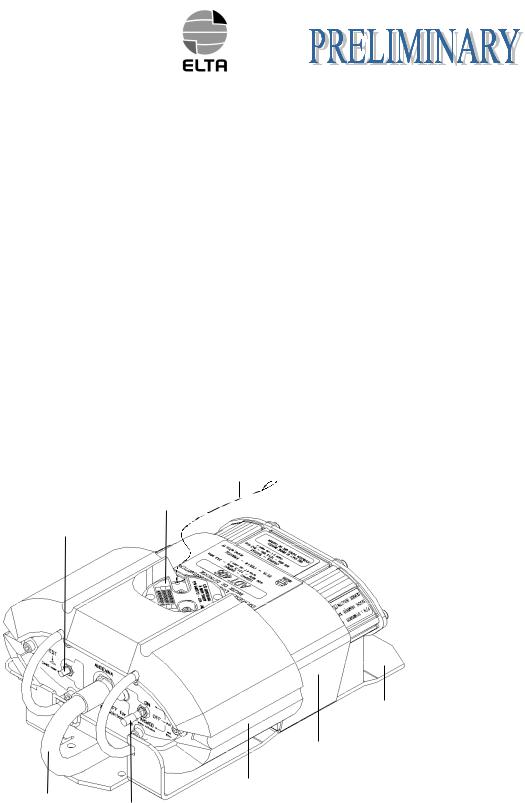
2. GENERAL DETAILS OF THE ELT ADT 406 S A. Purpose of the ELT ADT 406 S (Ref. Fig. 2)
The ELT ADT 406 S consists of a beacon that incorporates means of attachment.
The ELT ADT 406 S is designed to transmit a digital distress signal to satellites that are part of the COSPAS/SARSAT SYSTEM.
These satellites transmit the captured signal to the reception stations on the ground.
This signal is transmitted on the 406.028 MHz frequency and is used to precisely locate and identify the ELT ADT 406 S.
It also transmits a 121.5 MHz and 243 MHz signal to facilitate the final approach of the distress scene (homing).
It can be triggered manually or automatically by means of a water sensor.
This ELT meets the latest JAR OPS and ICAO recommendations.
Any encoding protocol defined by COSPAS/SARSAT can be used with ELT ADT 406 S including country code assignation.
Metalic strap
Identification and water sensor module
Self test push button
Support
Velcro strap
Float
Whip antenna
ON/OFF/ARMED switch
ELT ADT 406 S- Presentation
Figure 2
Page 14
June 6/05
 Loading...