

Page 1
Add-on for Microsoft
Add-on for Microsoft
Flight Simulator
Flight Simulator
and FS2004!
and Prepar3D v3
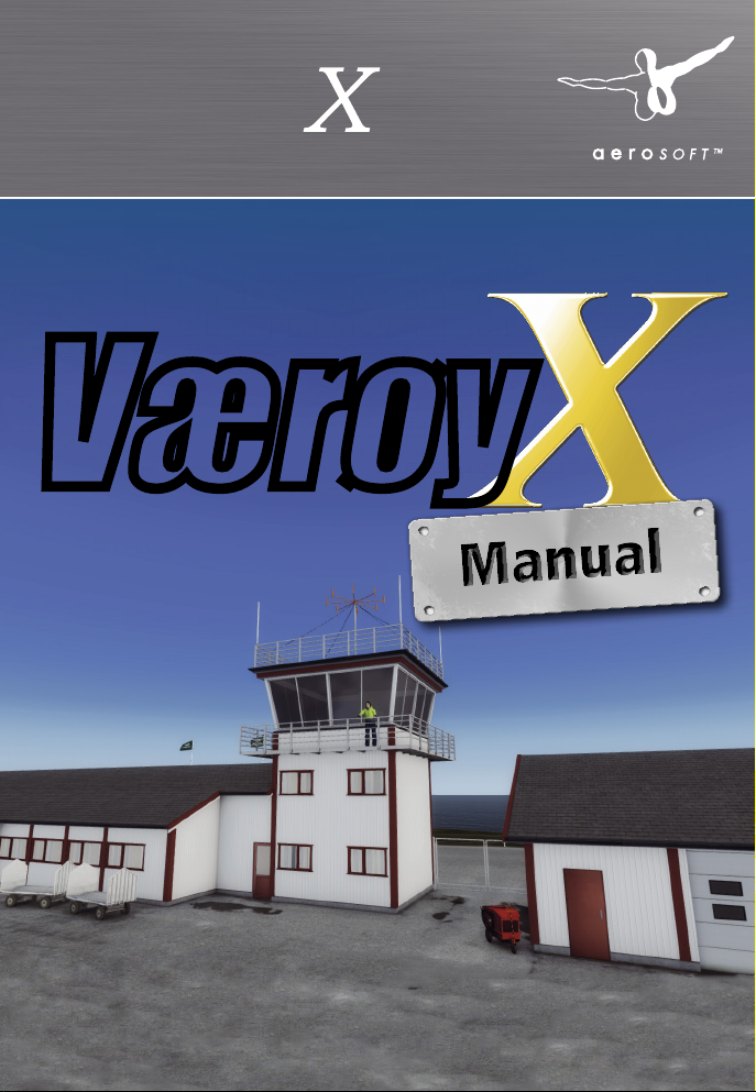
Approaching
Quito
Værøy
Page 2
Værøy X
Developed by: Jo Erlend Sund
Manual: Jo Erlend Sund / Aerosoft
Installation: Andreas Mügge
Værøy X
Handbuch
Copyright: © 2016 / Aerosoft GmbH
Flughafen Paderborn/Lippstadt
D-33142 Büren, Germany
Tel: +49 (0) 29 55 / 76 03-10
Fax: +49 (0) 29 55 / 76 03-33
E-Mail: info@aerosoft.de
Internet: www.aerosoft.de
www.aerosoft.com
All trademarks and brand names are trademarks or registered of their
respective owners. All rights reserved. /
namen sind Warenzeichen oder eingetragene Warenzeichen ihrer jeweiligen
Eigentümer. Alle Urheber- und Leistungsschutzrechte vorbehalten
Aerosoft GmbH 2016
Alle Warenzeichen und Marken-
2 3
Erweiterung zum /
Add-on for
.
Microsoft Flight Simulator X & Prepar3D v3
Page 3

Værøy X
Inhalt
Systemvoraussetzungen .......................................................... 6
Installation .............................................................................. 6
Deinstallation ......................................................................... 7
Urheberrechte ........................................................................ 7
Geschichte ............................................................................. 7
Szenerie-Features.................................................................. 10
Flughafen-Informationen ...................................................... 11
Operative Verfahren.............................................................. 11
Anflug ...................................................................... 11
Landung/Abflug ........................................................ 12
Voraussetzungen an PIC ............................................ 12
Allgemein ................................................................. 12
Heliport-Informationen ......................................................... 12
Konfigurationstool ................................................................ 13
FTX Norway installiert: ............................................... 13
Nordlichter: ............................................................... 13
Animationen: ............................................................ 13
Texturoptionen: ......................................................... 14
Texturauflösung: ....................................................... 14
Nacht Texturen: ......................................................... 14
Ambient Occlusion Qualität: ...................................... 15
Specular Maps Qualität: ............................................ 15
Statische Schatten: .................................................... 15
Content
System requirements ............................................................ 16
Installation ............................................................................ 16
Uninstall the scenery ............................................................. 17
Copyrights ............................................................................ 17
History .................................................................................. 17
Scenery Features ................................................................... 20
Airport Information .............................................................. 21
Operational Procedures ......................................................... 21
Approach .................................................................. 21
Landing/departure ..................................................... 22
PIC requirements ....................................................... 22
General ..................................................................... 22
Heliport Information ............................................................. 22
Configuration Tool ................................................................ 23
FTX Norway installed ................................................. 23
Northern lights .......................................................... 23
Animations ............................................................... 23
Texture Options: ........................................................ 24
Texture Resolution: .................................................... 24
Night Textures: .......................................................... 24
Ambient Occlusion Quality: ....................................... 25
Specular Maps Quality: .............................................. 25
Static Shadows: ......................................................... 25
Aerosoft GmbH 2016
4 5
Page 4

Værøy X
Systemvoraussetzungen
Um die Szenerie „Værøy X“ möglichst störungsfrei fliegen zu können,
benötigen Sie:
• Microsoft Flight Simulator X mit Service Pack 2 oder Acceleration oder Microsoft Flight Simulator X Steam Edition oder
Lockheed Martin Prepar3D V3
• Dual Core Prozessor mit 3 GHz
• ca. 4,9 GB freien Festplattenspeicher
• 4 GB RAM (8 GB empfohlen)
• 3D-Grafikkarte mit 1GB
Installation
Sie müssen als Systemadministrator angemeldet sein, bevor Sie mit der
Installation von „Værøy X“ beginnen können.
Um die Installation zu beginnen, starten Sie einfach die DownloadDatei. Nach der Sprachauswahl erscheinen zunächst einige Informationen und die Lizenzbedingungen. Lesen Sie sich die Informationen bitte
sorgfältig durch und klicken Sie dann auf „Weiter“. Anschließend
werden Sie zur Eingabe Ihrer E-Mail Adresse und des Produkt-Keys
aufgefordert. Bitte geben Sie diese Daten genauso ein, wie sie in der
Bestätigungsmail unseres Online-Shops zu lesen sind.
Danach wird das Installationsverzeichnis (Verzeichnis des Microsoft
Flugsimulators) automatisch gesucht und überprüft. Sollte die Installationsroutine das Microsoft Flugsimulator Verzeichnis nicht finden oder
Sie ein anderes Verzeichnis auswählen wollen, so können Sie dieses
über den „Durchsuchen”-Button festlegen.
Die Installationsroutine kopiert nun im Einzelnen die Daten der Szenerie
„Værøy X” in das Zielverzeichnis und meldet die Szenerie in der
Szeneriebibliothek an. Zuvor wird von der Scenery.cfg eine Sicherungskopie erstellt: „Scenery_CFG__BEFORE_VærøyX_was_installed”.
Deinstallation
Um die Szenerie zu deinstallieren, klicken Sie bitte auf die Windows
Start-Schaltfläche. Klicken Sie dann auf „Systemsteuerung“ und
schließlich auf „Software“ oder „Programme und Funktionen“. Sie
sehen nun eine Auflistung aller installierten Programme. Wählen Sie
das Programm, das Sie deinstallieren möchten, und folgen Sie den
Anweisungen.
Urheberrechte
DIE SOFTWARE, DAS HANDBUCH UND SONSTIGES ZUGEHÖRIGES
MATERIAL IST DURCH URHEBERRECHTSGESETZE GESCHÜTZT.
DIESOFTWARE WIRD LIZENZIERT, NICHT VERKAUFT. SIE DÜRFEN EINE
KOPIE DER SOFTWARE AUF EINEM COMPUTER FÜR IHRE PERSÖNLICHE, NICHT KOMMERZIELLE NUTZUNG INSTALLIEREN UND AUSFÜHREN. DIE SOFTWARE, DAS HANDBUCH UND ALLE ANDEREN ZUGEHÖRIGEN MATERIALIEN DÜRFEN OHNE VORHERIGE, SCHRIFTLICHE
ERLAUBNIS DER ENTWICKLER UND DER AEROSOFT GMBH WEDER
KOPIERT, FOTOKOPIERT, ÜBERSETZT, ZURÜCKENTWICKELT, DEKOMPILIERT, DISASSEMBLIERT ODER IN ANDERER FORM FÜR ELEKTRONISCHE MASCHINEN LESBAR GEMACHT WERDEN.
Geschichte
Værøy Island liegt am südlichen Ende des Lofoten-Archipels in
Nord-Norwegen. Der Name ist abgeleitet vom Altnordischen Namen
veðrøy, bestehend aus veor für Wetter und øy für Insel. Die ersten
Bewohner der Insel können anhand von 3000 Jahre alten Höhlenmalereien bis in die Bronzezeit zurückverfolgt werden.
Heute leben auf der Insel nur ca. 750 Menschen, die meisten davon
auf dem südlichen Teil der Insel namens Sørland (Südland). Diese
Gegend umschließt den größten Hafen der Insel sowie den neuen
Heliport.
Deutsch
Aerosoft GmbH 2016
6 7
Page 5

Værøy X
Die erste Flugverbindung nach Værøy wurde im Jahr 1965 mit dem
Wasserflugzeug DHC-3 Otter Widerøe geschaffen, das 2-3 Mal pro
Woche flog. Ausgebaut wurde dies später mit einer Helikopter-Route
zwichen Bodø und Værøy im Jahr 1973. Die Helikopter wurden
außerdem zu Such- und Rettungsaktionen in der Umgebung eingesetzt.
Bereits in den 60ern begannen die Diskussionen, einen Flughafen auf
der Insel zu errichten. Im Weg stand lange das raue und schwer
einzuschätzende Wetter und wie sich dieses auf die Zuverlässigkeit des
Flughafens auswirken würde. Drei Regionen wurden damals als
tauglich für einen Flughafen eingestuft. Kvalnes, Røssnesvågen und
Nordland. Von diesen Optionen war Nordland die kostengünstigste
Möglichkeit. In Untersuchungen, ausgeführt vom norwegischen
meteorologischen Institut, wurde damals festgestellt, dass sich auch
die Witterung in Nordland am besten für einen Flughafen eigne. 1984
stimmte der Bürgermeister zu, dass der neue Flughafen in Nordland
gebaut werden solle; auch wenn erste Testflüge zeigten, dass die
Witterungsverhältnisse schlechter waren als zuerst angenommen. Viele
befürchteten damals, dass der Flughafen nicht mit der Zuverlässigkeit
der Helikopter mithalten könne und viele lokale Politiker wollten lieber
die Helikopter an Stelle des Flughafens behalten.
Der Bau des Flughafens begann 1985 und war Teil einer großen
Investition der norwegischen Regierung mit dem Ziel, kleine und
abgelegene Regionen mit dem Festland zu verbinden. Unter den
weiteren Flughäfen, die zu diesem Zweck gebaut wurden, befand sich
unter anderem Røst, Værøys südliche Nachbarinsel. Værøy und Røst
wurden 1986 eröffnet und waren nahezu identisch.
Værøy verfügte über einen 800 Meter (2.636ft) langen Runway der
direkt nördlich vom Berg Teisthammeren lag und den Landeanflug auf
Grund von heftigen Turbulenzen und Abwind als äußerst anspruchsvoll
gestaltete. Dies war auch der Grund, warum die Zuverlässigkeit des
Flughafens am schlechtesten in ganz Norwegen war und in Höchstzeiten bei 50% abgesagten Flügen lag. Um dieses Problem anzugehen, wurde der Landekurssender weiter vom Flughafen entfernt und
Widerøe schränkte ihre Crews noch weiter mit selbst aufgestellten
Regulierungen ein. Die Piloten hatten z. B. keine Erlaubnis, um bei
Südwind mit mehr als 20kts zu starten oder zu landen.
Im Jahr 1989 schränkte ein Vorfall mit einer von Widerøes Twin Otter
Maschinen die Airline-Abläufe am Flughafen weiter ein. Die Maschine
verlor die Kontrolle auf Grund von heftigen Turbulenzen und konnte
erst 300 Fuß über dem Wasser die Kontroller zurückerlangen.
Am 12. April 1990 wurden bei der Landung des Widerøes Flugs 839
Windstärken von 270 Grad und 23kts gemessen. Die Piloten sagten
allerdings nach der Landung, der Wind sei aus allen Richtungen
gekommen. Nach einem schnellen Wendemanöver war die Maschine
bereit für den Rpckflug nach Bodø. Da die Winde nicht im Bereich der
speziellen Südwind-Einschränkungen lagen, sollte das Flugzeug
planmäßig starten.
Als die Maschine zum Runway fuhr, wurden Windböen bis 57 Knoten
gemeldet, welche den Höchstwert für Bodentätigkeiten von 50
Knoten überstieg.
Direkt nach dem Start drehte der Wind wieder und Augenzeugen
berichteten, dass die Maschine erst schnell anstieg und dann stark
abfiel, gefolgt von einem weiteren schnell Anstieg, bevor es in den
Wolken verschwand. Während des Austeigens nahm der CVR ein
lautes ratterndes Geräusch im Cockpit und das Geräusch von asynchron laufenden Propellern war. Weniger als eine Minute nach dem
Start gab der Copilot durch, dass der Flug in ernsten Problemen
steckte. Sekunden später empfang der Værøy Tower einen Notruf,
gefolgt von einem lauten Knall.
Im Unfallbericht stellte sich später heraus, dass der Wind die maximalen strukturellen Beschränkungen des Flugzeugs überstieg und einen
Bruch im Steuerruder verursacht hatte, wodurch die Maschine
unkontrollierbar wurde.
Nach dem Unfall wurde Værøy Airport geschlossen und nie wieder für
den kommerziellen Flugverkehr geöffnet.
Deutsch
Aerosoft GmbH 2016
8 9
Page 6

Værøy X
Szenerie-Features
• Realistische Nachbildung des Flughafen Værøy (ENVY) und
Værøy Heliport (ENVR)
• Vollständig kompatibel mit FSX SP2 (Acceleration), FSX SE und
P3Dv3
• Akkurates Terrainmodell mit schräger Landebahn
• Sehr genaues 3D-Höhenmoidell der Insel
• Fotorealistische Texturen über die gesamte Insel
• Saisonale Veränderungen inklusive 3D-Schnee
• Alle Flughafengebäude sehr detailreich enthalten
• Eigene Stadt- und Hafenmodelle
• Mit optimalen Modellierungs- und Texturierungstechniken
erstellt, um optimales Aussehen und Schwuppdizität zu
erreichen
• Hochdetaillierte Bodentexturen dank Specular-Effekten und
Normal Mapping
• Eigene Windhosen- und Flaggen-Animationen, abhängig von
Windstärke und -richtung
• Komplett eigene Anflug-, Landebahn und PLASI-Lichter
• Realistische Nachteffekte
• Eigener Polarlicht-Effekt
• Terminal-Innenraum-Modelle sowohl am Flughafen als auch am
Heliport
• Zahlreiche Animationen und Spezialeffekte
• Konfigurationstool für optimale Schwuppdizität auf vielen
Systemen enthalten
Flughafen-Informationen
Land Norwegen
Gemeinde Værøy
ICAO ENVY
Koordinaten 67° 41‘ 18‘‘N 012° 40‘ 54‘‘E
Landebahn - 07-25
- Harte Oberfläche / Asphalt
- 800x30 Meter
- Beleuchtet
- APAPI RW07/25
Frequenzen AFIS, 119.40
NAV-Aids (Terminal)
LOC/DME 109.70 ( VY / ...- -.--- )
(Non-Terminal)
Røst VOR 113.50 ( RS / .-. ... )
Operative Verfahren
Anflug
Kein PIC soll einen Anflug planen/durchführen, wenn einer oder
mehrere der folgenden Punkte überschritten werden:
a) durchschn. Winde Røst 070-250/20kts (through S)
b) Winde in Höhe 5000’ 070-250/30kts “
c) Lokale Winde (letzte 2 min) 070-240/25kts “
Deutsch
Aerosoft GmbH 2016
10 11
Page 7

Værøy X
Landung/Abflug
Landungen oder Abflüge sollen nicht geplant oder durchgeführt
werden, wenn Windrichtung und -stärke am Bodenlevel wie folgt
angegeben werden:
VARIABLE WITH STRENGTH OVER 15KTS (including ‚‘gust‘‘)
Voraussetzungen an PIC
PIC sollen einen besonderen Flugcheck von standardisierenden
Instrukteuren erhalten, es sei denn der PIC ist innerhalb der letzten 12
Kalendermonate als PIC an dem Flughafen geflogen.
Allgemein
Die oben genannten Wind-Einschränkungen liegt immer noch im
Ermessensrahmen des individuellen Piloted.
Der Pilot muss sich jederzeit den vorliegenden Bedingungen anpassen
und sicherstellen, dass die Sicherheit nicht gefährdet ist.
Heliport-Informationen
Land Norway
Gemeinde Værøy
ICAO ENVR
Koordinaten 67° 39‘ 16‘‘N 012° 40‘ 54‘‘E
Landebahn - 03-21
- Harte Oberfläche / Asphalt
- 56x32 Meter
- Beleuchted
Frequenzen Bodø FIS, 126.450
NAV-Aids (Terminal)
RNAV (GNSS) 027°
RNAV (GNSS) 200°
RNAV (GNSS) 267°
Treibstoff/Service NIL/NIL
Konfigurationstool
WICHTIG: Bitte achten Sie darauf das Konfigurationstool als
Admin auszuführen. Andernfalls funktioniert das Tool nicht und
Sie bekommen eine Fehler-Meldung.
Die Szenerie beinhaltet ein Konfigurationstool, welches es dem Nutzer
ermöglicht, die Details der Szenerie nach der persönlichen Vorliebe
anzupassen. Dieser Teil des Handbuchs erklärt die verschiedenen
Anpassungsmöglichkeiten.
FTX Norway installiert:
Diese Einstellung passt die saisonalen Veränderungen an FTX Norway
an.
Nordlichter:
Die Szenerie beinhaltet einen eigens erstellten Aurora Borealis Effekt,
diese Option erlaubt es diesen ein- bzw. auszuschalten
Animationen:
Diese Option passt die Anzahl animierter Objekte, die von der Szenerie
geladen werden, an.
Deutsch
Aerosoft GmbH 2016
12 13
Page 8

Værøy X
Texturoptionen:
Da Microsoft Flight Simulator X und Lockheed Martin P3D auf 32-bit
basieren, ist die nutzbare Speichermenge begrenzt. Darum kann es
passieren, das Nutzer mit vielen installierten Add-ons Probleme mit
OOM (out of memory errors) bekommen können.
Das Konfigurationstool ermöglicht, es die Größe fast aller Texturen, die
für die Szenerie geladen werden, anzupassen. Dadurch können Sie die
Speichernutzung des Flughafens Ihrem System anpassen.
Sie haben 3 Optionen, aus denen Sie auswählen können LOW, HIGH,
ULTRA.
Um sicherzustellen, dass die Texturen wie erwünscht angezeigt
werden, müssen Microsoft Flight Simulator X Nutzer TEXTURE_MAX_
LOAD in Ihre fsx.cfg file einfügen.
Wenn Sie die „LOW“ Texturen Option installieren:
TEXTURE_MAX_LOAD=1024
Wenn Sie die „LOW“ Texturen Option installieren:
TEXTURE_MAX_LOAD=2048
Wenn Sie die „LOW“ Texturen Option installieren:
TEXTURE_MAX_LOAD=4096
Texturauflösung:
Steuert den Großteil der Texturen, die durch die Szenerie geladen
werden.
Ambient Occlusion Qualität:
Einige Teile der Szenerie haben separate Ambient Occlusion Maps.
Diese steuert Umgebungsschatten auf großen Arealen wie Terminalmauern, Terminal-Innenausstattungen usw.
Diese Option steuert die Größe der Ambient Occlusion Map, die
geladen wird.
Specular Maps Qualität:
Specular Maps werden genutzt, um Oberflächen-Helligkeit zu steuern.
Diese Option bestimmt die Größe der Specular Map, die geladen wird.
Statische Schatten:
Diese Option lädt die vorgerenderten Schattierungen auf einigen
Texturen in der Szenerie (Bodentexturen, Terminalwände, Gebäude
usw.) Dies ist vor allem für FSX Nutzer oder P3D Nutzer, die nicht die
dynamische Schatten Option nutzen.
Deutsch
Nacht Texturen:
Steuert die Größe der Nachttexturen, die geladen werden.
Aerosoft GmbH 2016
14 15
Page 9

Værøy X
System requirements
In order to run “Værøy X“ without any problems your system will have
to meet the following minimum requirements:
• Microsoft Flight Simulator X with Service Pack 2 or Acceleration
or Microsoft Flight Simulator X Steam Edition or Lockheed
Martin Prepar3D V3
• Dual Core Processor with 3 GHz
• ca. 4.9 MB free space on your hard disk
• 4 GB RAM (8 GB recommended)
• 3D graphics card with 1GB
Installation
You have to be logged in with administrator rights before you start the
installation. After you have chosen your preferred installation language, the welcome screen appears and with some important information
and the license agreement. Please read it carefully.
You will be asked to insert your email address and the product key.
Please insert them exactly the way they were written in the confirmation mail you received of our online shop. The installation program will
attempt to locate the correct path of Microsoft Flight Simulator. If this
path cannot be successfully located, or if you wish to install to another
location, then you will have to enter the correct path for installation
manually. In order to do this, click on “Browse“ and navigate to the
correct path.
Before the installation program starts to copy the files onto your hard
disc, you will be presented with all the installation details. The
installation program will now copy all files onto your hard disc and
subsequently register the scenery in the scenery library. A backup copy
of the original Scenery.cfg will also be made.
Uninstall the scenery
To uninstall the scenery, click on the Windows „Start”-button. Then
select „Settings” und „control panel”. Go to „Software” or „Programs“, and double click. You will see a list with all installed programs.
Select the program you want to uninstall and follow the instructions.
Copyrights
THE MANUAL, DOCUMENTATION, VIDEO IMAGES, SOFTWARE, AND
ALL THE RELATED MATERIALS ARE COPYRIGHTED AND CANNOT BE
COPIED, PHOTOCOPIED, TRANSLATED OR REDUCED TO ANY ELECTRONIC MEDIUM OR MACHINE LEGIBLE FORM, NEITHER COMPLETELY
NOR IN PART, WITHOUT THE PREVIOUS WRITTEN CONSENT OF
AEROSOFT. THE SOFTWARE IS FURNISHED «AS IS» AND IT DOES NOT
COME FURNISHED WITH ANY GUARANTEE IMPLICIT OR EXPRESS. THE
AUTHOR DECLINES EVERY RESPONSIBILITY FOR CONTINGENT
MALFUNCTIONS, DECELERATION, AND ANY DRAWBACK THAT
SHOULD ARISE, USING THIS SOFTWARE.
Copyright © 2016 AEROSOFT. All rights reserved. All trademarks and
brand names are trademarks or registered trademarks of the respective
owners. Copyrights are serious stuff. If you find any pirated copies of
this software please notify us at support@aerosoft.com. We will make
sure reports of copyrights violation are rewarded.
History
Værøy island is located on the southern tip of the Lofoten archipelago
in Northern Norway.
It‘s name is derived from the Old Norse name of veðrøy, the first part
of the name veðr meaning weather and øy island. Settlements on the
island can be traced back to the bronze ages, with 3000 year old cave
paintings that were discovered in 1997.
English
Aerosoft GmbH 2016
16 17
Page 10

Værøy X
Currently the island has a population of only 748, most of them living
on the southern side of the island named Sørland (Southern land). This
area surrounds the main harbor and is also where the heliport is
located.
The first air service to Værøy was in 1965, using the DHC-3 Otter
Widerøe offering seaplane flights to and from the island two or three
times a week. This was later expanded with helicopter routes between
Bodø and Værøy in 1973. These helicopters were also used for search
and rescue in the area.
Discussions of building a hard surface airport on the island were
happening as early as the 1960‘s.
The focus was on the harsh and unpredictable weather and how this
would affect regularity.
Three areas were considered as suitable for an airport to be built,
Kvalnes, Røssnesvågen and Nordland. Out of these Nordland (Northern land) was the cheapest option. During surveys done by the
Norwegian Meteorological institute they concluded that Nordland also
had the most favorable weather. In 1984 the Mayor approved
Nordland to be the location of the new airport, though test flights had
shown that the weather was not as favorable as first thought.
Many feared that the airport would not be able to keep the same
regularity as the helicopter service, and many local politicians would
rather scrap the airport and keep the helicopters.
Construction of the airport began in 1985, this was part of a large
investment by the Norwegian government to connect small and
remote locations by air travel. Among the other airports being build
was Røst, Værøys neighboring island to the south. Værøy and Røst
airport opened in 1986, with both of them looking close to identical.
Værøy had one runway of 800 meters (2.626ft) laying just north of
the mountain of Teisthammeren, making flights to and from the
airport difficult due to heavy turbulence and downdrafts.
Due to this the airport had one of the lowest regularity in Norway,
with a peak of 50% of the flights being canceled. To try to address the
problems the Localizer was moved further away from the airport and
Widerøe restricted its flight crews even further with self imposed
limitations they had to follow. The pilots were not allowed to land or
take off if the wind was from a southerly direction with speeds above
20kts.
In 1989 an incident with one if the Widerøes Twin Otter aircraft
further restricted the airlines‘ operation to the airport. The aircraft lost
control in heavy turbulence and did not regain control before less than
300 feet above the water.
On the 12. April 1990 Widerøes flight 839 landed at Værøy after it‘s
flight from Bodø-Røst-Værøy.
During the approach the tower at Værøy reported winds from 270
and 23kts, though after landing the pilots commented on the wind as
it was blowing from everywhere.
After a quick turnover the aircraft was ready to depart back to Bodø.
As the winds were not inside the southern sector the special limitation
for the airport did not apply.
When the aircraft was taxiing to the runway winds were reported as
57 knots, exceeding the aircraft limit for ground operations (50 knots).
Right after take-off the winds shifted again, eye witnesses reported
the aircraft rapidly climbing then falling, followed by another rapid
climb before it disappeared into the clouds.
During the climb-out the CVR picked up a loud rattling in the cockpit
and the sound of un-synchronized propellers. Less than a minute into
the flight the co-pilot indicated that the flight was in trouble. Seconds
later Værøy tower received a distress-signal followed by a load bang.
The accident report later revealed that the winds exceeded the
structural limitations of the aircraft, causing a crack in the rudder
leaving the aircraft uncontrollable.
Værøy airport was closed after the accident and never opened again
for commercial traffic.
English
Aerosoft GmbH 2016
18 19
Page 11

Værøy X
Scenery Features
• Realistic recreation of Værøy Airport (ENVY) and Værøy
Heliport (ENVR)
• Fully compatible with FSX SP2 (Acceleration), FSX SE and P3Dv3
• Accurate terrain model with sloped runway.
• Highly accurate 3D elevation model of the island.
• Photo-realistic textures covering the whole island.
• Seasonal variations including 3D snow.
• All airport buildings included in high detail.
• Custom city and harbour models.
• Created using optimal modeling and texturing techniques for
optimal performance and visuals.
• Highly detailed ground textures utilizing specular effects and
normal mapping.
• Custom windsock and flag animations depending on wind
speed and direction.
• Fully custom approach, runway and PLASI lights.
• Realistic night time effects.
• Custom Aurora Borealis effect.
• Terminal interior models for both the airport and heliport
included.
• Multiple animations and special effects.
• Configuration Tool included for optimal performance on a wide
range of systems.
Airport Information
Country Norway
Municipal Værøy
ICAO ENVY
Coordinates 67° 41‘ 18‘‘N 012° 40‘ 54‘‘E
Runway - 07-25
- Hard Surface / Asphalt
- 800x30 metres
- Lighted
- APAPI RW07/25
Frequencies AFIS, 119.40
NAV Aids (Terminal)
LOC/DME 109.70 ( VY / ...- -.--- )
(Non-Terminal)
Røst VOR 113.50 ( RS / .-. ... )
Operational Procedures
Approach
No PIC shall plan/execute an approach if observations exceed one or
more of the following items:
a) Mean winds Røst 070-250/20kts (through S)
b) Winds aloft 5000’ 070-250/30kts “
c) Local winds (last 2 min) 070-240/25kts “
English
Aerosoft GmbH 2016
20 21
Page 12

Værøy X
Landing/departure
A landing/departure shall not be planned or executed if wind directions and strength at ground level (TWR) are reported as:
VARIABLE WITH STRENGTH OVER 15KTS (including ‚‘gust‘‘)
PIC requirements
PIC shall be given a special flight check from standardizing Instructors,
unless PIC has flown as PIC at the airport within the last 12 calendar
months.
General
The above mentioned wind limitation is still up to critical assessment
by the individual pilot.
The pilot must at all times adapt to the conditions and make sure
safety is never compromised.
Heliport Information
Country Norway
Municipal Værøy
ICAO ENVR
Coordinates 67° 39‘ 16‘‘N 012° 40‘ 54‘‘E
Runway - 03-21
- Hard Surface / Asphalt
- 56x32 metres
- Lighted
Frequencies Bodø FIS, 126.450
NAV Aids (Terminal)
RNAV (GNSS) 027°
RNAV (GNSS) 200°
RNAV (GNSS) 267°
Fuel/Service NIL/NIL
Configuration Tool
IMPORTANT: Please make sure to run the configuration tool as
an administrator. Otherwise the configuration tool doesn’t
work and you get an error message.
This scenery includes a configuration tool. The tool is designed to let
the end user adjust the level of detail in the scenery to their preference. This part of the manual explains the different options you have
available.
FTX Norway installed
This option adjusts the seasonal changes to match FTX Norway.
Northern lights
The scenery includes a custom Aurora Borealis effect, this option
allows you to switch it on or off.
Animations
This option adjusts the number of animated objects that are loaded by
the scenery.
English
Aerosoft GmbH 2016
22 23
Page 13

Værøy X
Texture Options:
Since Microsoft Flight Simulator X and Lockheed Martin P3D are 32-bit
software the amount of memory these programs are able to use is
limited. Therefore users who have a lot of add-ons installed can run
into issues with OOM (Out of memory errors).
The config tool gives you the option to customize the size of almost all
the textures being loaded for the scenery, this way you can tailor the
memory load of the airport to match your setup.
You have 3 options to choose from LOW, HIGH, ULTRA.
To make sure the textures are displayed properly in the simulator
Microsoft Flight Simulator X users must make sure they have TEX-
TURE_MAX_LOAD edit in the fsx.cfg file.
If you install the “LOW” texture option set:
TEXTURE_MAX_LOAD=1024
If you install the “HIGH” texture option set:
TEXTURE_MAX_LOAD=2048
If you install the “ULTRA” texture option set:
TEXTURE_MAX_LOAD=4096
Texture Resolution:
This controls the majority of the textures being loaded by the scenery.
Ambient Occlusion Quality:
Some parts of the scenery have separate Ambient Occlusion maps.
These maps control the ambient shadows on large areas like terminal
walls, terminal interior etc. This option controls the size of the ambient
occlusion map being loaded.
Specular Maps Quality:
Specular maps are used to control a surface or an object‘s shininess and
highlights. This option controls the size of the specular map being loaded.
Static Shadows:
This option loads pre-rendered shadows on some textures in the
scenery. (Ground textures, terminal walls, buildings etc.) This is mainly
recommended for FSX users or P3D users who do not use the dynamic
shadows option.
English
Night Textures:
This controls the size of the night textures being loaded.
Aerosoft GmbH 2016
24 25
Page 14
Værøy X
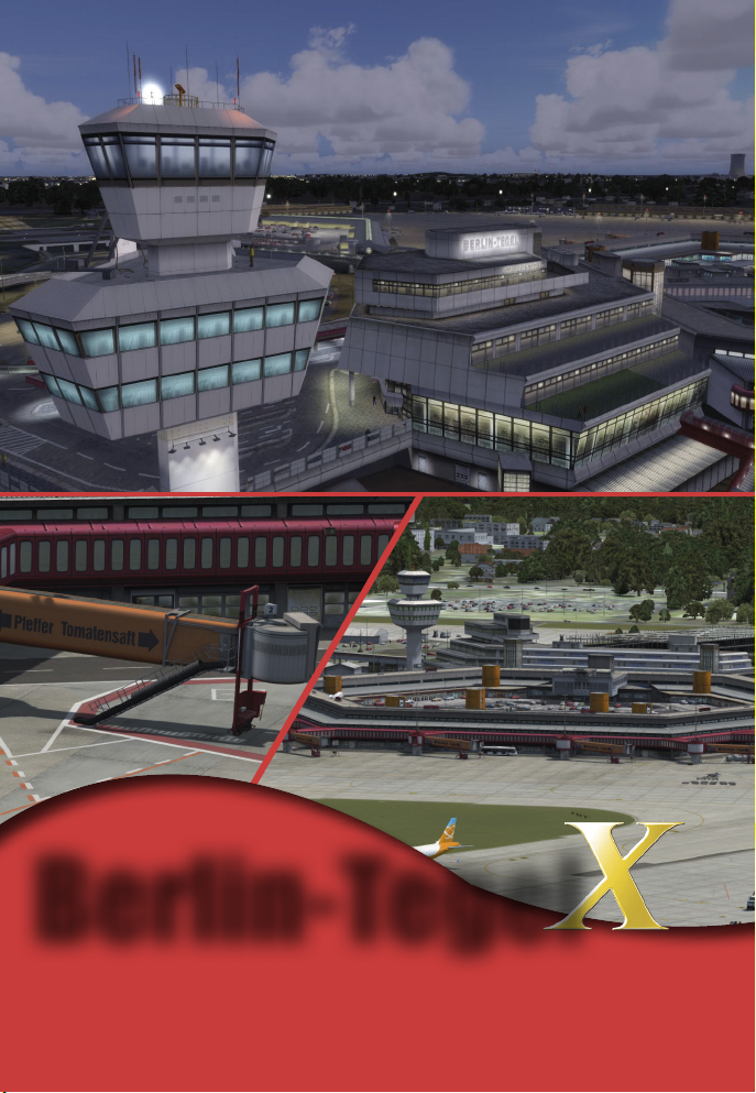
Berlin-Tegel
“Soon“ to be replaced by the new BER, Berlin-Tegel is still Berlin’s main
airport. Experience this new remake of one airport with its very own feeling.
Aerosoft GmbH 2016
www.aerosoft.com
26 MF
Page 15

THE main hub in Germany offers a aerial
coverage of 140km². The new Mega Airport
Frankfurt V2.0 for FSX / P3D v3.2 - available
now!
FRANKFURT V2.0
www.aerosoft.com
Page 16

Værøy X
• FMS-integrated Configuration Module for on-the-fly
configuration changes
• True to original Weather and Ground Radar (TAWS)
• Highly accurate flight physics
Aerosoft GmbH 2016
Soon available at: www.aerosoft.de
• Most recend technology for FSX and P3D
• high resoution aerial images
• detailled animations
28 MF
 Loading...