

Page 1

LimeSim’s
Page 2

Limesim Antarctica X 1.00 Antarctica X 1.00 Manual
Page 1 of 59
CONTENTS
COPYRIGHTS ........................................................................................................................................................... 3
CREDITS................................................................................................................................................................... 3
SYSTEM REQUIREMENTS ........................................................................................................................................ 4
CONTACT SUPPORT ................................................................................................................................................ 4
ABOUT FLYING IN ANTARCTICA .............................................................................................................................. 5
FLYING AS A PILOT .................................................................................................................................................. 6
WEATHER ................................................................................................................................................................ 7
RADIO REPORTS -FLIGHT FOLLOWING ................................................................................................................... 8
ANTARCTIC COMMUNICATIONS ............................................................................................................................. 8
GENERAL ................................................................................................................................................................. 8
AVIATION COMMUNICATIONS IN ANTARCTICA ..................................................................................................... 8
TIBA- TRAFFIC INFORMATION BROADCASTS BY AIRCRAFT -126.90 ....................................................................... 9
TYPICAL PHRASES ................................................................................................................................................. 10
BRITISH FERRY FLIGHT FROM CANADA TO ANTARCTICA ..................................................................................... 13
FLIGHT REPORT (BY D. HARDIE) ............................................................................................................................ 13
AIRCRAFT, “AIRLINES” AND COMMON FLIGHT ROUTES....................................................................................... 16
FLIGHT PLANS ....................................................................................................................................................... 19
HISTORY AND FURTHER READING OF ANTARCTIC AVIATION ............................................................................... 21
BACKGROUND INFORMATION ABOUT THIS SCENERY .......................................................................................... 25
ELEVATION DATA .................................................................................................................................................. 25
AIRSTRIP AND NAVIGATIONAL DATA .................................................................................................................... 25
AERIAL IMAGERY .................................................................................................................................................. 25
FSX LIMITATIONS .................................................................................................................................................. 25
ANIMATED ICEBREAKERS ...................................................................................................................................... 26
RV POLARSTERN ................................................................................................................................................... 26
USGC HEALY .......................................................................................................................................................... 27
MS LIMESIM .......................................................................................................................................................... 27
BASES AND AIRPORTS - DESCRIPTION .................................................................................................................. 27
MCMURDO (USA) ................................................................................................................................................. 27
HELIPAD ....................................................................................................................................................... 27
NZIR – ICE RUNWAY ..................................................................................................................................... 28
NZWD – WILLIAMS FIELD AND NZPG – PEGASUS FIELD .............................................................................. 28
SCOTT BASE (NEW ZEALAND) ............................................................................................................................... 28
ROTHERA STATION (UNITED KINGDOM) .............................................................................................................. 28
CASEY STATION (AUSTRALIA) ............................................................................................................................... 29
Page 3

Limesim Antarctica X 1.00 Antarctica X 1.00 Manual
Page 2 of 59
NEUMAYER STATION III (GERMANY) .................................................................................................................... 29
SANAE IV (SOUTH AFRICA) .................................................................................................................................... 29
NOVOLASAREVSKAYA (RUSSIA) ............................................................................................................................ 30
PATRIOT HILLS ...................................................................................................................................................... 30
KUNLUN AIRPORT (CHINA) ................................................................................................................................... 30
ADVISED DISPLAY SETTINGS ................................................................................................................................. 31
GRAPHICS MENU .................................................................................................................................................. 31
AIRCRAFT MENU ................................................................................................................................................... 32
SCENERY MENU .................................................................................................................................................... 33
TRAFFIC MENU: .................................................................................................................................................... 34
SCENERY TOOL ...................................................................................................................................................... 35
CHANGE SEASONS: ............................................................................................................................................... 35
STATIC AIRCRAFT: ................................................................................................................................................. 35
MCMURDO APPROACH LIGHTS: ........................................................................................................................... 35
LOD RADIUS (FIX BLURRY TERRAIN): .................................................................................................................... 35
COMPATIBILITY WITH OTHER ADD-ONS ............................................................................................................... 36
FAQS ..................................................................................................................................................................... 36
APPENDIX A CHARTS ............................................................................................................................................. 39
APPENDIX B LIST OF ALL BASES COVERED ............................................................................................................ 57
Page 4

Limesim Antarctica X 1.00 Antarctica X 1.00 Manual
Page 3 of 59
COPYRIGHTS
The manual, documentation, video images, software, and all the related materials are copyrighted and cannot
be copied, photocopied, translated or reduced to any electronic medium or machine legible form, neither
completely nor in part, without the previous written consent of AEROSOFT. THE SOFTWARE IS FURNISHED «AS
IS» AND IT DOES NOT COME FURNISHED WITH ANY GUARANTEE IMPLICIT OR EXPRESS. THE AUTHOR DECLINES
EVERY RESPONSIBILITY FOR CONTINGENT MALFUNCTIONS, DECELERATION, AND ANY DRAWBACK THAT
SHOULD ARISE, USING THIS SOFTWARE.
Copyright © 2011 AEROSOFT & LimeSim. All rights reserved. Microsoft Windows, and Flight Simulator are
registered trademarks or trademarks of Microsoft Corporation in the United States and/or other Countries. All
trademarks and brand names are trademarks or registered trademarks of the respective owners. Copyrights
are serious stuff. If you find any pirated copies of this software please notify us at support@aerosoft.com. We
will make sure reports of copyrights violation are rewarded.
Aerosoft GmbH
Lindberghring 12
D-33142 Büren
Germany
www.aerosoft.com
CREDITS
Concept: LimeSim
Programming: LimeSim
Project Management: Lime Sim, Mathijs Kok (Aerosoft)
Manual, documentation: Lime Sim, D. Hardie
Installer: Andreas Mügge (Aerosoft)
Testing: Several good folks who will all be getting a copy
Data from the following external providers has been used in this product:
Terrain data of Casey, Mawson and Davis: Data courtesy of the Australian Antarctic Division Data
Centre © Commonwealth Australia 2008
If interested in a copy of an orthophoto or any other data provided by the Australian Antarctic Data
Centre, please contact them directly. They have supported our project with one of the best datasets
around for Antarctic bases and are extremely well organized: http://data.aad.gov.au
Terrain data of Rothera, Halley and Sky Blu: © British Antarctic Survey: www.antarctica.ac.uk
Higher resolution elevation data in most mountainous areas based on modified ASTER GDEM data:
ASTER GDEM is a product of METI and NASA
Terrain data for area south of the Dry Valleys: Sourced from LINZ, Crown Copyright Reserved
Land Information New Zealand: www.linz.govt.nz
Terrain data of McMurdo and Scott bases and Landsat imagery: U.S. Geological Survey: www.usgs.gov
Many, many thanks go to Milton Shupe for permission to use his superb Dash 7 aircraft as static
model in Rothera as well as Aerosoft for permission to use their Twin Otter model as static aircraft all
over Antarctica.
Animated Windsock 3D model by Arno Gerretsen, Jörg Dannenberg and Jon Patch
www.fsdeveloper.com
Aerial photo of SanaeIV in this manual: Wikipedia
Page 5

Limesim Antarctica X 1.00 Antarctica X 1.00 Manual
Page 4 of 59
Disclaimer: Please note that although we have done our best to investigate information about real world
Antarctica and flight operations, this manual is NOT supposed to be understood like a “Bible on Antarctic
Flying”! Therefore we cannot be held responsible for information that is incorrect but we would be more than
happy about your feedback if you know more than we do.
SYSTEM REQUIREMENTS
Intel Core 2 Duo E6850 CPU (Core 2 Quad advised)
2 GB RAM
Direct X 9 compatible Graphics Card with minimal 512 MB
Microsoft FSX (with SP2 or Acceleration)
Windows XP, Windows VISTA, Windows 7 (fully updated), 64 bits version highly recommended
Adobe Acrobat® Reader 8 minimal to read and print the manual
(1)
(1)
Available for free, download at: http://www.adobe.com/prodindex/acrobat/readstep.html
CONTACT SUPPORT
Support for this product is done by Aerosoft. We prefer to do support on the support forum for one simp le
reason, it is fast and efficient because customers help customers when we are sleeping.
Aerosoft forums: http://www.forum.aerosoft.com/
We feel strong about support. Buying one of our products gives you the right to waste our time with questions
you feel might be silly. They are not.
Page 6

Limesim Antarctica X 1.00 Antarctica X 1.00 Manual
Page 5 of 59
ABOUT FLYING IN ANTARCTICA
Much of the following text has been written by D. Hardie who was flying Twin Otters in Antarctica for a few
seasons during the last years. He was the most valuable supporter of “Antarctica X”. Based on his input and
knowledge we created this scenery as close to the “real thing” as we could get.
Flying in Antarctica is probably one of the most exhilarating
environments on our planet. It is unique in that it is remote,
and is almost uninhabited except for the few research stations,
manned by scientists from the countries of the world. The
climate is harsh and there are no roads, no trees, and no
buildings to get any sense of scale to the place. The cold
unpolluted air means that you can see for great distances, and
have spectacular views.
There are several mountain ranges, the most interesting lying
to the north on the Antarctic Peninsula. From a pilot's
perspective, Antarctica is a challenging but immensely rewarding environment, and relatively few people ever
get the opportunity to fly here. This new simulator brings maximum realism to a community of simulator
pilots, and allows them to experience for themselves the scenery, logistics and the challenges of operating
safely here.
The Antarctic season only lasts for a maximum of 6 months, as quickly the Austral summer changes to winter
when it becomes too cold, windy, and eventually is in total darkness for a few months of the year. Flying
cannot take place in these conditions so the opportunity is taken for maintenance to be carried out in Canada,
and the crews given a well-earned rest. The flying season begins at the start of October, when the aircraft are
ferried south from Calgary, down through North and South America, where they are then configured onto skis.
The final hop is then made from Punta-Arenas over the Drake Passage and into Antarctica via Rothera
Research Station-home to the British Antarctic Survey. The ferry trip takes about two weeks, and is an
adventure in itself. Kenn Borek Air, currently the largest operator of Twin-otters in the world, send several
aircraft down to Antarctica via this route. They have aircraft in support of the NSF or National Science
Foundation-American science funded programme, as well as Antarctic Logistics Expeditions- a company which
provide tours for climbers and tourists in the region. They also have a Basler- or turbine powered DC-3 on skis,
which can carry the larger items of equipment, in Antarctica.
Once in Antarctica the Kenn Borek machines disperse, and the British Antarctic Survey aircraft operate from
Rothera, and one aircraft from Halley-to the east of the
peninsula. Kenn Borek aircraft continue to fly deeper into
the continent, via the blue ice runway at "Sky-Blu", where
they change onto board skis-much lighter and more rugged
than the hydraulic wheel skis. From here they continue to
Patriot Hills at the Ellsworth Mountains, and then more
machines fly onto McMurdo Research Station.
Patriot Hills is a seasonal logistics centre and a depot for
carrying climbers into the Vinson Massif, where they can
then climb the highest mountain- Mount Vinson. The flight
in here is a challenge and only contemplated in perfect
weather.
Page 7

Limesim Antarctica X 1.00 Antarctica X 1.00 Manual
Page 6 of 59
FLYING AS A PILOT
To fly in the Antarctic several extra skills are honed which are different from every other part of the world.
Firstly the ability to drag skis is important. The technique involves landing in a suitable area, and then dragging
the skis along the surface with just the right balance of power to keep the aircraft flying. The purpose of this is
to dislodge any snow surface and expose any crevasses beneath thus ensuring the area is safe to land on. The
skis are trailed for about 30 seconds, the luxury of flying in Antarctica is that runways are not limited by length,
or obstacles for most of the time. Once this is completed the pilot gets airborne again and at a low height
usually commences a 270 degree turn to the right, so as to put the freshly made ski tracks on his left hand side.
A low circuit is then flown at a couple of hundred feet, and a close inspection is made- looking for crevasses
before deciding that the location is safe to land on. The height is important, because if it is flown any higher,
the subtle change in colour of the snow may be too difficult to see, if a crevasse lurks beneath.
It is worth mentioning that the skis are of
sufficient area to maintain the aircraft safely
on the surface, of even a soft snow surface.
To step outside, it is possible for the pilot to
sink up to the knees if the surface is soft.
When the aircraft is landed, it is usual to
continue to taxi along the surface, creating a
taxi loop at each end of the newly formed
runway, so as to create a preformed track to
follow, when it is time to depart. Just before
shutting down the engines, the aircraft is left
to stand for a couple of minutes to allow the
temperature of the ski to match that of the
snow. The aircraft is then taxied forward
another couple of meters and shutdown. The
reason for this is to allow the heat generated by the friction of the skis over the snow to dissipate. If this is not
done, then the skis often melt the surface layer which then quickly refreezes and sticks the aircraft to the
surface. No amount of power will dislodge the aircraft, and the only option is then to shut down and dig
around the skis to dislodge them from the ice beneath.
Take off on the snow is easy, but again a couple of techniques are worthy of comment. The Twin-Otter is
vulnerable in the nose-ski area due to the heavy nose ski structure and the small nose gear attachment point.
To prevent damage over bumpy surfaces the control wheel is held full back whilst take-off power is applied.
This is to keep the weight off the nose gear, and to ensure an earliest take off distance, as well as preventing
damage to the nose structure. As soon as the aircraft becomes airborne, with the stall warner blaring, the pilot
checks forward slightly, to allow airspeed to increase for the climb-out.
When flying in Antarctica, safety is uppermost in the pilot's mind as help is usually a long way off. As soon as a
field party is dropped off, they establish HF communications by field radio, as this is the only means they have
of summoning assistance if they need support. The pilot's job is not done when flying the aircraft, as the
aeroplane must be safely unloaded, bringing skidoos, sledges, tents, fuel and supplies to the field camps.
Depending on the distance to the camp, it is not impossible for a field party to be entirely self-sufficient for a
couple of weeks, with the contents of one or two plane loads.
Page 8

Limesim Antarctica X 1.00 Antarctica X 1.00 Manual
Page 7 of 59
Some flights, the pilot is able to carry fuel for the entire round trip, -usually a three hour endurance, plus an
hour of reserve fuel. Others, the fuel must be taken along as fuel drums, which are then deposited, so that
they can be used on the return journey. The Twin-Otter will carry three 40 gallon fuel drums inside- or 300lbs
of fuel-per drum. Careful planning uses the least amount of fuel, as the cost of transporting fuel into remote
locations rises rapidly, the further away one flies.
WEATHER
Unlike the rest of the world- weather reports can be tricky to
obtain and at times unreliable. Satellite imagery is used and relayed
verbally by radio to pilots either from met forecasters on station or
else on location at the depots. Many sites do not have a manned
presence, if even they have ever been visited before, so inputs are
reserved until weather is perfect- clear blue skies, bright sunshine,
and no overhead cloud cover. This is to enable the best chance of
spotting crevassing as mentioned earlier.
Some useful weather links:
http://www.aipchile.gob.cl/index.php/camara_ubicacion/show/designador/SCCI
This is where you can get the actual weather for Chile as well as live links to the webcams. If you are lucky
you may be able to see the BAS Twin-Otters here on their ferry flights during October and March. You can
also access the live weather reports for Patriot Hills and the Union Glacier from here
http://www.aipchile.gob.cl/
Select Antarctica from the menu and then Patriot Hills or Union Glacier from the drop down menu.
http://amrc.ssec.wisc.edu/data/view-data.php?action=view_animation&product=satellite/composite/IRHO
For real time satellite weather images
http://amrc.ssec.wisc.edu/data/
This one is the best for all sorts of weather information live from Antarctica
http://www.antarctica.ac.uk/images/webcams/rothera/
Live webcam for Rothera Research Station
http://www.antarctica.ac.uk/met/rothera_forecast/realtime.html
Weather forecasts and current weather reports from the same base – in some cases even including cloud
type information in addition to the cloud layers. A perfect source to create realistic Antarctic weather
themes in FSX!
http://www.wunderground.com/global/stations/89062.html?bannertypeclick=infobox
For general weather situation at Rothera including forecasts and images.
http://www.bom.gov.au/ant/handbook/handbook.shtml
“The International Antarctic Weather Forecasting Handbook” is a perfect lecture for those interested in
some more in depth knowledge about weather in Antarctica.
Page 9

Limesim Antarctica X 1.00 Antarctica X 1.00 Manual
Page 8 of 59
RADIO REPORTS -FLIGHT FOLLOWING
No formal air traffic control exists as such. The position and therefore potential search area of an aircraft is
radioed into base every 30 minutes until touchdown, so that the flight-follower is aware of where an aircraft is.
No ground radar exists, so positions are plotted on a large plotting chart at the home base. Once on ground,
the time of next call is transmitted before shutting down the aircraft.
Flying days are long due to the continuous hours of daylight, and at the end of the six months, the air crews
are ready to begin the long ferry trip home, back for maintenance. Ferry fuel tanks are again installed for the
flight home, and skis are removed and packed away for next season, once they reach Punta-Arenas airport, at
the southern end of Chile, South America. It is an enjoyable journey home, flying along the coast of Chile, up
through South America, Panama, Mexico, then across the US and into Canada.
ANTARCTIC COMMUNICATIONS
Again mainly written by D. Hardie, this section focuses on communications around the Peninsula bases, which
should be similar all over Antarctica. Please note that this chapter should be seen as guideline for online pilots
because FSX will never be able to offer you an “ATC” like that:
GENERAL
Some information on the way communications work in the Antarctic may prove to be of some interest
generally, as well as specifically to the users of Antarctica X. Communications is perhaps the most important
aspect of living and working in Antarctica, whether they be on an individual level- or at an international- base
to base level. These are achieved by a variety of means, those mentioned here are by no means exhaustive,
and several other specific technologies are available.
Interpersonal communications is achieved on base by using a series of handheld VHF radios between key
personnel. These are also used for field scientific parties who may be spread a distance apart by a few hundred
yards , when travelling by skiddoo. The uniquely ultra-cold environment, coupled with exposure to sunspot
activity due to the closer distance to sun radiation, can cause a lot of static interference with radios. In such
cases, the VHF and HF radios may be affected as to be unusable. Satellite Iridium phones may sometimes be
used, but they too can be affected by solar storms and are much more expensive to operate.
AVIATION COMMUNICATIONS IN ANTARCTICA
The aircraft operating in the Antarctic are typically fitted with two VHF radios, and two HF radios, as well as an
individual satellite phone, in the cockpit, which can be removed if required. During operations close to basewithin about 50-80 miles, the VHF radios are used, much the same as in any normal air traffic control situation
at any airport in the world.
All radios are tested on the ground, before flight, and after the engines started, so that any problems are
recognised, and steps can be taken to correct any faults. Once the aircraft is airborne, the change to HF radios
occurs and position checks are transmitted every 30 minutes flying time. Details given are current position,
altitude, next waypoint position, estimated time of arrival, and then the next waypoint after that. This follows
a set format, and is adhered to, so any other pilot flying in the vicinity will know that another aircraft is enroute and its approximate current location.
As times between transmissions may be as much as 30 minutes, there may be long silences on the radio, so
any other aircraft getting into the air is given an update on any other aircraft activity by the "Flight Follower".
The Flight Follower is a communications expert at Rothera whose job it is to listen in to all aircraft
transmissions and plot them on a large board in the Operations Tower, showing the Antarctic region. He can
Page 10

Limesim Antarctica X 1.00 Antarctica X 1.00 Manual
Page 9 of 59
then relay messages from other aircraft, provides updated in-flight weather reports, as well as logistical
information to the pilots. The Flight Follower provides an Air-Ground Radio Information service which
effectively provides all information that could be of help to air operations as well as boating operations around
Rothera.
Once airborne a pilot must state "Airborne", and similarly
when landing deep field must make a statement of
intention to land with the ski status (usually skis down),
along with the position.
The exception to this is at Sky Blu, where the blue ice
runway is so hard that landings are usually carried out on
the wheels with "skis-up". The Borek aircraft change onto
Board skis shortly after arrival in Antarctica, offering a
more rugged and lighter landing gear, which has not any
associated problems of the hydraulically operated skis
springing a leak. Once an aircraft has landed, he
transmits this to home base along with a time of next communication, so that the flight follower will know
when to expect the next call, and the aircraft may then be shut down.
If the HF radios are not readable due to static then the same reports can be made by satellite phone to the
Rothera operations tower, via the normal phone lines.
Sledge parties rely for their very survival on HF radios. Their very first task when dropped off by aircraft, and
before it leaves, is for the field team to set up the radio and establish radio communications, as this is the only
way the team can communicate with home base and summon assistance in an emergency, or to request more
supplies or a pickup by aircraft. The Pilot will not leave the team until he is satisfied that they can
communicate correctly with home base.
The position reports are usually by reference to pre-designated waypoints, or else by actual reference to GPS
latitudes and longitudes, enabling a precise location to be found. Each international base has its own
communication frequency as stated in the AFIM- Antarctic Flight Information Manual- a published document
by agreement with all member states that have a claim to sectors of Antarctica.
Most bases respect the use of English the internationally agreed language, but not all adhere to it, depending
on the ability and competence of the radio operator, to speak in English.
Requests by pilot for a runway report or weather can be quite subjective and open to interpretation, as some
ground radio operators have very little formal training in aviation weather reporting. In fact this author flew
one individual to a forward supply depot, at short notice, where he was to spend a few weeks manning the
radios and carrying out resupply tasks and making weather observations.
When asked what training he had received the individual was surprised to hear of his forthcoming duties and
replied that he had had "no training" at all. There then followed a brief crash course in meteorology and
weather observation reporting, for the remaining duration of the flight.
TIBA- TRAFFIC INFORMATION BROADCASTS BY AIRCRAFT -126.90
This is exactly as it sounds and is used primarily as a listening frequency, on which pilots monitor other pilot's
transmissions giving position reports and more importantly any weather conditions or reports on the surface
condition- (i.e.- soft snow or hard polished slippery ice) which may be of interest. Fuel states may also be
transmitted such as numbers of fuel drums remaining, if refuelling is to take place on arrival.
Page 11

Limesim Antarctica X 1.00 Antarctica X 1.00 Manual
Page 10 of 59
The frequency is generally used as a chat frequency between pilots (reports can be made of icing conditions in
flight), but respect is made also so that it is not cluttered up with irrelevant chatter, when another aircraft may
need it for transmitting some important information. The other frequency which is monitored is 121.5 MHzthe international distress frequency, and no transmissions may be made on this except for an emergency
situation.
To summarise, VHF radios are used for aircraft comms close to base, and HF radios are used further away.
Satellite phones are used when the VHF and HF radios are unusable for whatever reason. And they may make
calls anywhere across the world.
TYPICAL PHRASES
These are some typical phrases you might hear on a Twin Otter flight from Rothera to Fossil Bluff.
The flight begins once the pre-flight walk around has
been completed, the fuel uplift has been entered in the
aircraft technical log, and a copy of the load sheet has
been handed to the ground crew.
Before engine start, a check of the VHF radio is made:
Aircraft: " Rothera Radio, this is Victor Papa
Foxtrot Bravo Bravo requesting radio check and
airfield information."
Rothera Ops Tower: " Roger Victor Papa Foxtrot
Bravo Bravo, this is Rothera Radio reading you
strength five, are you ready to copy the latest
weather?"
Aircraft: " Roger Rothera, go ahead."
Rothera: " The latest weather ob ( abbreviation for observation) at time 1100 zulu ( note zulu is the
aeronautical term for Greenwich Mean Time , which is the time set on the aircraft clock, and which is
entered in the aircraft papers, log, tech log , etc.) is wind 360 at 12 knots, visibility 8 km, cloud few at
1000 feet, temperature zero, dew point minus 8, QNH 1012.
Aircraft: "Roger weather copied, QNH 1012"
Note it is not necessary to read back all of the weather, but it is mandatory to read back any altimeter pressure
setting – QNH value.
Aircraft: "This is VP-FBB ready for start".
Rothera: "Roger V-BB, start at your discretion, time check 1101 zulu.”
Aircraft engines are now started, and the after start check-list is carried out, from memory using a panel scan
technique, and then backed up with reading and confirming from a paper checklist, stowed in the map pocket
just inside the pilots cockpit door.
Once the generators are brought online and the aircraft is self-powered, the signal is given for the ground crew
to disconnect the ground powers supply, and a radio check is made on the other radios.
Aircraft: "This is V-BB radio check on fives" – this is referring to the HF frequency on the number one
HF radio box selected to 5080.
Rothera: "Roger V-BB , reading you strength five"
Aircraft: "This is V-BB radio check on sevens" - this is the radio frequency selected to 7775.
Rothera: "Roger V-BB reading you strength five"
Page 12

Limesim Antarctica X 1.00 Antarctica X 1.00 Manual
Page 11 of 59
Radio strength is graduated in five increments from one being the weakest and barely audible to five, being
the loudest and clearest radio signal. There is no measure of this in the cockpit and is purely a subjective
assessment done by the pilot.
Aircraft: "Rothera Traffic this is VP-FBB entering and backtracking runway three six".
Rothera: "V-BB, roger, there is no known traffic to affect you, report ready for departure."
Aircraft : "Roger, wilco"
The aircraft now enters and back tracks the runway.
Whilst taxying, the pilot does some of the pre-takeoff checks, and at the end of the runway, turns
around and lines up along the take-off runway
direction. He now completes checks, flight controls,
power run up, and checks that the auto feather and
beta-back-up propeller systems are functioning
correctly. See the Twin-Otter specific manual for
exact details.
Aircraft: "Rothera traffic this is V-BB ready
for departure".
Rothera: "Roger, V-BB, surface wind now
350 12 gusting 15 knots, take-off at your
discretion.
Aircraft : "Roger, V-BB rolling runway 36"
When airborne:
Aircraft: "V-BB is airborne".
Rothera: "Roger V-BB, your airborne time is at 1108 zulu, next report passing waypoint bravo."
Aircraft: "Roger next call bravo".
Note: there is no Alpha waypoint, but the first waypoint is bravo a point to the south of Rothera about 40 mins
flying time by twin-otter. Successive waypoints are charlie, delta, and echo, which take the aircraft about 10
mins flying time from the forward supply depot Fossil-Bluff.
Every 30 mins the met office issue a weather "ob", obtained from the Rothera Met Office, who in turn get the
information by HF radio or sat-phone from the various field camps or field supply depots. Again the weather is
copied onto the pilots navigation log, and the QNH ( sea-level pressure reading) is read back.
Note that at some locations there is no reliable QNH setting, if no-one exists on the ground. In this case a best
guess QNH is set, but more importantly great reliance is placed on the radio altimeter which gives the height
above the surface up to 2500 feet. Above this height and the pressure altimeter is used, with a healthy margin
for any high ground beneath.
Aircraft: "This is V-BB with position report"
Rothera: "Go-ahead"
Aircraft: "V-BB is at position Bravo at time 1148 zulu, altitude 5000 feet, estimate charlie time 1228
zulu, delta next".
Rothera: "Roger charlie time 1228 zulu, next report charlie"
Aircraft: "Wilco".
Similar position reports are made at charlie, delta and echo, or if heading in a different direction then latitudes
and longitudes will be read out every 30 mins flying time. The purpose of this is to allow a "flight-follower" at
Rothera to plot the position of the aircraft on a large board of the Antarctic in the ops tower, and therefore
Page 13

Limesim Antarctica X 1.00 Antarctica X 1.00 Manual
Page 12 of 59
know the general area the pilot is operating in at any one time, as there is no radar surveillance. The flight
continues, and once VHF comms is lost, the position reports are made on the HF radio equipment, which are
usually much noisier with static background hissing and crackles.
When approaching Fossil Bluff (in this case our destination), and within range- approximately 15 mins flying
time, the VHF radio is used to talk to the ground party to obtain their latest weather situation. Further mention
may be made as to the on-board cargo, plus on-board passengers, as well as what cargo or personnel will be
embarking for the next flight. On final approach a HF transmission is made to Rothera:
Aircraft: "Rothera this is V-BB on finals for Fossil Bluff, skis are down".
Rothera: "V-BB roger, next report on the deck."
Aircraft: “Wilco".
Note the status of the skis (up or down) is always made to serve as a final check for the pilot to double check
that his skis are actually in the required position, even though this should be ascertained in the landing
checklist.
Aircraft: "Fossil-Bluff this is V-BB on finals for the skiway, skis are down."
Fossil Bluff Apple Hut: "V-BB -roger skis down".
Once on the ground the pilot taxies in towards the fuel drums where refuelling and offloading of cargo can
take place and carries out the after -landing checklist.
Aircraft on HF: "Rothera, this is V-BB, on the deck at Fossil-Bluff, shutting down, next radio call will be
in one hour and thirty minutes from now."
Rothera: "Roger Bravo Bravo, next call in one hour and thirty from now, time now 1330 zulu.”
The aircraft is then shutdown, and further communications can be carried out using the aircraft radio, using
the aircraft batteries, but for short periods of time to preserve the battery life in the ultra-cold environment.
Once the engines are started again and the generators connected, the on-board battery will recharge, as there
is no ground power supply at remote field stations away from Rothera.
Page 14

Limesim Antarctica X 1.00 Antarctica X 1.00 Manual
Page 13 of 59
BRITISH FERRY FLIGHT FROM CANADA TO ANTARCTICA
This is a flight done by the BAS Twin Otters every season. If you want to re-fly this in Flight Simulator we highly
recommend reading the recommendations for add-on sceneries and the “Flying in Antarctica” and
“Flightplans” chapters. Please note that the Flightplan files supplied with “Antarctica X” do not exactly match
the flights described here as the flight route can vary slightly from year to year. It’s up to you which flight
routing you choose. Furthermore we recommend that you have a look at the supplied Google Earth™ file
showing the route, which can be found in your windows Start menu.
FLIGHT REPORT (BY D. HARDIE)
The Antarctic Ferry-flights are the punctuation to the start and end of the flying season. A lot of preparations
go into these flights, and the goal is simple: To fly the aeroplanes as quickly as possible from Canada to Punta
Arenas, in readiness for the final leg over the Drake Passage, fully configured with Skis, and into Antarctica.
Pilots arrive in Calgary at the start of the trip to stock up on 2 weeks’ worth of provisions which have to be
loaded into the aircraft for the pilot and his mechanic. The flights start early in the morning and finish in the
late afternoon/evening so there is seldom time to go to shops and buy food en- route. All of the food and
equipment, including aircraft spares and personal clothing is carefully weighed and loaded into the aircraft.
The two large ferry tanks are installed in the aircraft by now, and the equipment has to be carefully installed as
there is very little room for manoeuvre inside the Twin-Otters.
First a couple of words about the fuel capacity of the Twin-Otter aeroplane:
The ferry tanks hold 1576 lb of fuel in each tank, which gives the aeroplanes an extra 6 hours of endurance.
This is in addition to the standard tanks which are located in the lower fuselage, under the cabin floor. The
capacity of the two tanks are 1235 lbs in the forward tank and 1341 lbs in the rear tank.
The wing tip tanks hold a further 300lbs in each side, which adds another hour onto the endurance. (Note the
Twin-Otter uses 600 lbs fuel per hour which makes the arithmetic easy. This is 10lbs per minute of flying, so all
the pilot has to do is multiply the flight time in minutes by 10 and you have the required fuel for the flight).
Thus we have a total fuel capacity of 6334 lbs or 10 and a half hours of flight before the engines will stop.
When you are flight planning, don't forget to add in a contingency, as well as fuel for diversion and for taxying
on the ground too.
The flight plans are submitted at the flight briefing office on the morning of departure, but international
clearances are usually arranged a few weeks in advance. A commercial company is used to obtain the
“Overflight" clearance numbers to satisfy the various countries regulatory authorities, and the aircraft
insurance certificates must also be in order to comply with this.
A few notes on Customs and Immigration are perhaps worthy of discussion. When planning to fly from one
country to another, pilots cannot just decide to fly to wherever it suits them best. Each country has a "Port of
Entry" or several "Ports of Entry" which are recognised first landing destinations. This is where the customs
formalities are completed, and customs inspectors may inspect the contents of the aircraft to ensure that only
recognised goods are being carried through the country. Consequently, if the weather deteriorates at the "Port
of Entry", then a diversion must be nominated which is also a "Port of entry”, or if this is not possible then the
customs authorities must be notified so that special arrangements can be made. To do otherwise may incur a
hefty fine and legal proceedings!
The first leg from "Springbank, Calgary" to Casper in Wyoming, is flown just as winter is beginning in the
Northern Hemisphere, so there is an incentive to depart soon before the snow fall begins. The aeroplane is
heavily laden and the aeroplane is very slow to climb, especially when departing Springbank, which is already
3937 feet above sea level.
Page 15

Limesim Antarctica X 1.00 Antarctica X 1.00 Manual
Page 14 of 59
On a clear day the view is enjoyable, flying over the forests of Canada -watch out for the view of the Rocky
Mountains to the west, and then over the canyons and badlands into the US Border , passing some Native
American Indian Reservations and down into Casper itself. Watch out for the site of the Little Bighorn
Battlefield on your left as you pass Billings and head towards Sheridan.
Casper is situated at the base of an escarpment and there are always some interesting business jets here as
well as executive military turboprops. There are also some Cessna Caravans based here which fly the mail for
Fed-Ex. The airfield itself goes back to 1942 and was a large training airfield for WW2 bomber crews including
B-17 flying fortresses, B-24's and B-29's. Many of the original war-time hangers and buildings still survive to
this day.
The second day consists of two flights- Casper down into Liberal, Kansas for a refuelling stop. This is to comply
with US regulations which do not permit any fuel to be carried in the ferry tanks. There is an aircraft museum
here and several cold war jets are parked at the end of the parking ramp. You can take a closer look at these
whilst you refuel. After a quick pit-stop, the journey continues from Casper down to Hobby Airport-one of the
airports in Houston, Texas. Of note are the many oil wells and "nodding donkeys" to be seen through the state.
The night is spent here, and the aircraft are parked up at the Atlantic Aviation executive terminal on the northeastern side of the airfield. Departure in the morning will be early for the long leg over the Gulf of Mexico
down to Cozumel, Mexico.
Day Three begins with a climb out amidst the busy early morning commercial jet departures from Hobby,
Houston. Several oil platforms are seen on the initial climb out to cruising height over the sea. Much of the
flight is over featureless ocean but usually in sunshine. There is no option for a quick diversion out here if
things go wrong, so "Point of no return" calculations are made so that the pilot knows when to turn back or
when to continue to destination.
A rest day is usually taken in Cozumel, before pressing on once again, crossing the sea, then the coast of
Honduras and Nicaragua before making the spectacular arrival into Panama City airport alongside the Panama
Canal. Be careful here as there are several airfields within close proximity, including one on the downwind leg.
The arched bridge over the canal is a prominent landmark here. The airport was the scene of the attack by US
forces against the drug funded Noriega administration in 1990. The city itself has many high rise buildings and
is an impressive sight. Park your aircraft here and clear customs and pay your landing fees and fuel bill.
When departing Panama, watch out for the hill straight ahead on takeoff, if departing initially to the north. The
hill has been systematically cut away in steps, as you fly towards it, in an effort to improve the terrain
clearance for aircraft. The airport is busy and you will see other Twin Otters arriving and departing on
schedules for Air Panama. After a few hours over the sea you will fly over equatorial jungle, and now land at
Guayaquil in Ecuador. Congratulations, you have now crossed the equator into the southern half of our planet.
Guayaquil- an international airport used by jets as well as turboprops, is situated in the heart of an
overcrowded city. An engine failure here on take-off with full ferry fuel is going to give marginal climb
performance, and if there is no other option, then a ditching in the Guayas river adjacent to the airport seems
the "best" course of action. Park your aircraft here, refuel and clear customs.
Watch out also for the giant tea-cup perched atop the hill to the side of the runway as you depart, before
setting off towards Arica – the northernmost airport in Chile. En-route you pass Lima in Peru, which is a
preferred tech-stop airport to take on more fuel if required. Also on this leg you will pass the famous Nazca
lines in the Atacama Desert.
Arica lies on the coast but is on the edge of a desert. Chilean permits and customs formalities are carried out
here which allows the journey to continue all the way down the Chilean coast- the longest country in the
world. There are spectacular views of the Andes on the way along- they are situated well inland though, so the
Page 16

Limesim Antarctica X 1.00 Antarctica X 1.00 Manual
Page 15 of 59
distant volcanoes look quite serene when seen on the approach into Puerto Montt. Watch out for the Very
Large Telescope on the hilltop at Cerro Paranal-they look like four large white cubes on the ridgeline, and also
the recently famous Chilean volcano at Puyehue-Cordon Caulle. When you arrive at Puerto Montt, park here.
Flying the last leg from Puerto Montt to Puntas Arenas is one of the most spectacular segments of the journey,
flying high up at 17000 feet on oxygen; you get a wonderful view of the Torres del Paine mountain peaks
between waypoint Kilak and Puerto Natales, on the left hand side of the aircraft. If the weather is bad it can be
hidden from view within the clouds. Strong winds from the west may bring turbulence over this area with
strong up and downdrafts which can exceed the performance capability of a heavy weight ferry aircraft.
Coupled with the potential for picking up clear and rime ice due to the moist supercooled air from the sea,
rapid airframe ice build-ups are a further hazard of flying this section of the route. Careful study of the enroute weather systems is advisable here. If the weather looks bad, best to wait another day.
The last few hours of the flight fly over barren hills leading into boggy and rocky windswept landscapes which
are a feature of the arrival into Punta Arenas. The airfield here is almost always windy, but there is a triangular
pattern of runways which gives plenty of options for an into wind landing. Park here.
At Punta Arenas, a day is then spent fitting skis to the aircraft and making any final adjustments before
heading out on the last long leg over the Drake Passage and down into the Antarctic. Chillean Air Force
Dragonflys A-37'Bs can be seen along with a residential Ilyushin IL76 transporter which runs expeditions from
here down to the blue ice runway at Patriot Hills and the Union Glacier on behalf of Antarctic Logistics and
Expeditions.
Once stocked up with last minute supplies, and the aircraft are fuelled up for the last long flight, take a last
look back at Punta Arenas, as you climb up and head "south" over the bay. It is the last look at civilisation,
greenery and vegetation you will see for six months.
The final ferry flight sector must be undertaken with special pre-flight care. The flight is a PNR or point-of-noreturn flight, up to which point a turn-back may still be made. After the PNR, the flight must be continued
come hell or high water, and if the weather at destination were to deteriorate, a landing on a clear patch on
the Antarctic continent may have to be considered, until conditions improve. To this end, Antarctic survival
equipment and survival rations are carried on board.
A careful study of the satellite weather charts is advisable, along with the meteorological forecast for the
destination. The flight is usually carried out with the crew wearing survival suits and lifejackets, although a
ditching in such a tempestuous sea would have a slim chance of survival for long, let alone a successful rescue.
Radio position reports are made by high frequency HF radio, at designated 30 minute waypoints, once out of
range of the shorter very high frequency VHF radios, used in commercial airspace.
After 8 hours of flying-welcome to the Antarctic, you have completed an amazing ferry trip and can now begin
the hard work of the Antarctic flying season for the next 6 months.
Recommended addon sceneries for the way south are ORBX’ “NA Northern Rokies” and “US Central
Rockies” for coverage of the first leg from Calgary about half way down to the next touchdown.
Unfortunately there are only few sceneries for the Latam area (yet) but add-ons like “FS Global – The
Americas” offer a good chance to spice up the Rockies all the way down a bit (because they are not that soft
hilly landscape south of the US as you see them in default FSX). “My Traffic” is a good product to bring you
lots of typical local air traffic.
Last but not least the freeware series “Photoreal Chile” seems to be the best scenery available for this flight,
since it covers a large chunk of the route flown, is for free and has a resolution that looks very decent at the
altitudes flown. Unfortunately most of this scenery’s files seem to have been lost after the server crash at
AVSIM.com and recovery of them in is doubtful.
Page 17

Limesim Antarctica X 1.00 Antarctica X 1.00 Manual
Page 16 of 59
AIRCRAFT, “AIRLINES” AND COMMON FLIGHT ROUTES
Considering the number of government organizations and private tour operators actively flying in Ant arctica it
is not easy to gather some reliable information about who’s flying what down there. Still this list is probably
the most complete available yet. What we describe here are the usual routes flown. Adding to that there is a
substantial amount of scientific flights that often return to the same base after some “sightseeing” or
touchdown in a remote are without any prepared strips.
Canada based Kenn Borek Air is by far the largest contract operator here. They have a large fleet ski
equipped Twin Otters and about two Basler BT-67/DC3-T (turbo equipped Dakota’s) flying all over
Antarctica every season. The Twin Otter’s usually fly for the US Antarctic Programme (most of them
are based in McMurdo), the Italian and French Antarctic Programmes (in a triangle between
Concordia-Dumont-D’Urville and Mario Zuchelli Station + shuttle flights between Mario Zuchelli and
McMurdo), the Australian Antarctic Division and some private Tour Operators. The Basler BT-67’s
usually operate around McMurdo and within the DROMLAN Network (see below).
http://www.borekair.com/
The USA has without a doubt the largest and most independent fleet down in Antarctica. The
backbone for intercontinental flights is the heavy C-17A Globemaster III operated by the US Air Force
between Christchurch (New Zealand) and McMurdo. Sometimes even the aged Lockheed C-141
Starlifter is being used although it seems it has been taken out of service recently. From McMurdo on
the backbone for long distance continental transportation (including to the South Pole) is the LC-130H
Hercules operated by the New York Air Guard, sometimes equipped with JATOS (rockets that enable
the aircraft to take off from runways that would otherwise be too short). Shorter fixed wing distances
or those to locations without a prepared landing strip are served by Kenn Borek’s Twin Otters (see
above). But even those aircraft fly all the way up to the South Pole.
For flights to the other destinations around Ross Island (McMurdo) and scientific camps in the dry
valleys, helicopters are used. Those helicopters bear liveries of the National Science Foundation but
are operated by PHI Inc., a company based in Louisiana. Their fleet down here consists of Bell 212 and
AS350 helicopters. There is a refuel base for helicopters called Marble Point (not part of the scenery
yet).
http://photolibrary.usap.gov/Portscripts/PortWeb.dll?quickfind=transportation_cat&catalog=Antarcti
ca&template=USAPgovSmallThumbs&sorton=cataloged&ascending=0&offset=228
The Royal New Zealand Air Force (RNZAF) uses C-130H Hercules aircraft for intercontinental shuttle
flights from Christchurch and is often sharing them with their partner. A RNZAF Boeing 757 has also
been seen at McMurdo but we don’t know if this is a regular visitor. To improve accessibility and to
bundle resources, most nations having bases in Dronning Maud Land (that is south of South Africa)
established the Dronning Maud Land Air Network, for short: DROMLAN. Among them are Germany,
Russia, South Africa, Belgium, Norway, Sweden and Japan. There is a dizzying number of different
operators and aircraft types active in that area,
http://www.scar.org/information/dromlan/dromlanflyer.pdf
Aged privately owned IL-76 aircraft operated by ALCI (Adventure Logistics International) are the
backbone of the DROMLAN Network. They fly cargo and passengers between Cape Town (South
Africa) to the hubs Novolasarevskaya and/or Troll from where they are usually picked up by smaller
aircraft to be brought to their final destinations. Russian Novolasarevskaya, also called “Novo
Airfield”, is the main hub but usually suffers from extensive melting from the mid of December to the
end of January making it unsuitable for the landing of a large and heavy IL-76. Therefore operations
are moved to the Norwegian Troll Skiway during that time.
http://www.alci.info/
Page 18

Limesim Antarctica X 1.00 Antarctica X 1.00 Manual
Page 17 of 59
The German Alfred-Wegener-Institut (AWI) operates another Basler BT-67, called “Polar 5” and a DO-
228 called “Polar 2” within the DROMLAN Network, which are a regular visitor of the Japanese and
South African bases as well. The German Research ship “Polarstern” carries a BO 105 helicopter.
http://www.awi.de/de/infrastruktur/fluggeraete/forschungsflugzeuge/ehemalige_flugzeuge/
It is quite difficult to find some information about what the Russian Government is flying down in
Antarctica. It seems like they are not too eager to publish too much information about their
programme. What can be said is that there is a group of AN-2’s (both default and turbo equipped)
based at Novolasarevskaya. Other Russian aircraft recently seen in Antarctica are MI-18 helicopters
(usually based on Russian Icebreakers), and Antonov AN-74.
The Japanese Antarctic Research Expedition (JARE) uses ship based Sikorsky S-61A helicopters and
two ski-equipped fixed-wing aircraft from their base in Syowa: A Pilatus Porter and a Cessna C182
Skywagon. The latter one was transported to Antarctica by ship because it doesn’t have enough range
to fly directly to Antarctica from the next continent.
The Norwegian Air Force flies a C-130H Hercules on its way from Cape Town (South Africa) to Troll as
well as a P-3 Orion.
The Swedish Air Force is using another C-130H-Hercules on the same route.
Despite having a skiway at its base the South African National Antarctic Programme (SANAE) doesn’t
have fixed-wing fleet. They use helicopters like the stylish Kamov KA-32 operated by Titan Helicopters
and two M2 Onyx operated by the nation’s 22nd squadron:
http://www.titanhelicopters.com/index.php?page_id=11&msg_id=25#news-double
http://www.af.mil.za/bases/afb_ysterplaat/22sqn.htm
The British Antarctic Survey (BAS) owns a fleet of 4 Twin Otters with a wheel/ski combo and one Dash
7. The Twin Otters are used for all kinds of
scientific flights and usually fly between Rothera,
Fossil Bluff, Halley and Sky Blu. The Dash 7 is
usually used to serve the long distance route
from Punta Arenas (Chile) or RAF Mount Pleasant
(Falklands) to Rothera and occasionally Sky Blu
(since the ice runway there is hard enough to
support wheels). All BAS aircraft are flown back
to Calgary (Canada) during the Austral winter.
Real-world flightplans for most BAS flights
(including the ferry flight down from Canada to
Antarctica) are part of “Antarctica X”. For more information read the “Flight Plans” and “Flying in
Antarctica” chapters in this manual. The HMS Scott and other UK Navy ships have Westland Lynx
helicopters based on them. There are no British helicopters based in Antarctica itself:
http://www.antarctica.ac.uk/living_and_working/aircraft_and_vehicles/aircraft/index.php
The Fuerza Aerea de Chile flies from Punta Arenas (Chile) to Teniente R Marsh Martin (SCRM) using a
C-130H Hercules. Occasionally those aircraft are equipped with JATOS (rockets in each side) that
enable it to take off from the short runway with heavy loads. In addition they operate their own Twin
Otter that can land at the skiway of Bernardo O’Higgins, another Chilean base on the Antarctic
mainland. A BO-105 helicopter with the same air force’s livery can also occasionally be spotted at
Teniente R Marsh Martin Base.
Similar to the Chileans the Fuerza Aerea Argentina also operates C-130H Hercules for flights from
Ushuaia to Marambio and has another Twin Otter based in its own hangar at Marambio. A helicopter
that can sometimes be seen here is an Air Force Huey.
Privately owned Aerovias DAP offers charter flights from Punta Arenas to Teniente R Marsh Martin
(SCRM). Customers can choose between a King Air 100 and a Bae 146. This is probably the quickest
Page 19

Limesim Antarctica X 1.00 Antarctica X 1.00 Manual
Page 18 of 59
and least expensive way for mere mortals to reach Antarctica by air.
http://www.aeroviasdap.cl/antartica.html
Probably the biggest private tour operator in Antarctica is Adventure Network International (ANI).
They offer various all-inclusive trips to their own base at Patriot Hills using an Ilyushin-76TD. From
here Twin Otters are used to fly climbers to the Mount Vinson Base camp for example or a Basler BT76 to fly other paying adventurers to the South Pole. ANI’s main base has recently been moved from
Patriot Hills to Union Glacier but the old runway at Patriot Hills remains open as a backup.
http://www.adventure-network.com/aircraft
Another operator of Twin Otter aircraft is the Institut polaire français (IPEV), which mainly uses them
between Dumont D’Urville and Concordia. They also use helicopters like the Eurocopter AS 350.
http://en.wikipedia.org/wiki/Eurocopter_AS350
South African Safair is probably the largest private operator of a C-130H Hercules fleet. They fly for
various Antarctic programs as for the Italian one from Christchurch (New Zealand) to Mario Zuchelli
Station’s sea ice runway when the sea ice is still there.
http://www.safair.co.za/
Last but not least there is one more important player in Austral Aviation: The Australian Antarctic
Division. In fact they are proud to offer the first comfortable shuttle to Antarctica using their own
Airbus A319-115LR (long range) for which they set up a large runway called “Wilkins Aerodrome” on
the ice shield southwest of Casey. Those flights start in Hobart (Australia) and fly directly to Wilkins.
From there transiting passengers change planes to smaller CASA-212 to fly on to bases like Mawson
(Rumdoodle Skiway) and Davis, which have smaller skiways. Another popular destination for the
smaller “CASA’s” is the picturesque Beaver Lake (see flightplans). The helicopters being used are
Eurocopter AS350’s. While all aircraft bear the Antarctic programme’s liveries, the fixed-wing aircraft
are operated by Skytraders Pty Ltd and the helicopters by Helicopter Resources Pty Ltd.
http://www.antarctica.gov.au/living-and-working/travel-and-logistics/aviation
Oops… looks like we forgot one: Quantas… A “normal” commercial airline you may ask? Yes! In fact
they don’t land there but Quantas offers very popular sightseeing flights over Antarctica either
departing from Sidney or Melbourne using a Boeing 747 or the new Airbus A380.
http://www.antarcticaflights.com.au/
Page 20

Limesim Antarctica X 1.00 Antarctica X 1.00 Manual
Page 19 of 59
FLIGHT PLANS
We have added a set of of real-world flight plans to this product. To open them, just click “Flight Planner” in
FSX and “Load”. All flight plans can be found in the following folder and its subfolders:
FSXmainfolder\Aerosoft\AntarcticaX\Flightplans\
Please note that these flight plans only represent small fragments of flights done in Antarctica (in fact only
those we could get waypoint information for). Most others are mentioned in the previous chapter.
Continental flightplans within Antarctica (and aircraft models)
DavisPlateau_to_RumdoodleMawson.PLN (CASA-212 or Twin Otter)
DavisPlateau_to_RumdoodleMawson_via_BeaverLake.PLN (CASA-212 or Twin Otter)
DavisPlateau_to_WilkinsCasey.PLN (CASA-212 or Twin Otter)
DavisPlateau_to_WilkinsCasey_via_BungerHills.PLN (CASA-212 or Twin Otter)
DavisPlateau_to_WilkinsCasey_via_Mirny.PLN (CASA-212 or Twin Otter)
FossilBluff_to_Halley.PLN (Twin Otter)
FossilBluff_to_Rothera.PLN (Twin Otter)
FossilBluff_to_SkyBlu.PLN (Twin Otter)
Halley_to_FossilBluff.PLN (Twin Otter)
Halley_to_Neumayer.PLN (Twin Otter, Do-228 or Basler BT-67)
Halley_to_Rothera.PLN (Twin Otter)
Kohnen_to_Neumayer.PLN (Do-228 or Basler BT-67)
Kohnen_to_Novolasarevskaya.PLN (Do-228 or Basler BT-67)
Marambio_to_Rothera.PLN (Twin Otter)
Neumayer_to_Halley.PLN (Twin Otter, Do-228 or Basler BT-67)
Neumayer_to_Kohnen.PLN (Do-228 or Basler BT-67)
Neumayer_to_Novolasarevskaya.PLN (Do-228 or Basler BT-67)
Neumayer_to_SanaeIV.PLN (Do-228 or Basler BT-67)
Novolasarevskaya_to_Kohnen.PLN (Do-228 or Basler BT-67)
Novolasarevskaya_to_Neumayer.PLN (Do-228 or Basler BT-67)
PatriotHills_to_Rothera.PLN (Twin Otter)
Rothera_to_FossilBluff.PLN (Twin Otter)
Rothera_to_Halley.PLN (Twin Otter)
Rothera_to_Marambio.PLN (Twin Otter)
Rothera_to_PatriotHills.PLN (Twin Otter)
Rothera_to_TenienteMarsh.PLN (Twin Otter)
RumdoodleMawson_to_DavisPlateau.PLN (CASA-212 or Twin Otter)
RumdoodleMawson_to_DavisPlateau_via_BeaverLake.PLN (CASA-212 or Twin Otter)
RumdoodleMawson_to_S17Syowa_via_RichardsonLake_and_Molodezhnaya.PLN (CASA-212 or Twin
Otter)
S17Syowa_to_RumdoodleMawson_via_Molodezhnaya_and_RichardsonLake.PLN (CASA-212 or Twin
Otter)
SanaeIV_to_Neumayer.PLN (Do-228 or Basler BT-67)TenienteMarsh_to_Rothera.PLN (Twin Otter)
WilkinsCasey_to_DavisPlateau.PLN (CASA-212 or Twin Otter)
WilkinsCasey_to_DavisPlateau_via_BungerHills.PLN (CASA-212 or Twin Otter)
wilkinscasey_to_davisplateau_via_mirny.pln (casa-212 or twin otter)
Page 21

Limesim Antarctica X 1.00 Antarctica X 1.00 Manual
Page 20 of 59
Intercontinental flightplans to/from Antarctica (and aircraft models)
Christchurch_to_McMurdoIceRunway.PLN (C17A Globemaster III, LC-130H Hercules, C-141 Starlifter)
The usual supply route for the US Antarctic Programme.
Hobart_to_McMurdoIceRunway.PLN (A319-115LR) Route usually flown when the ice at Wilkins
Aerodrome is not suitable for Airbus landings because of heavy melting.
Hobart_to_WilkinsCasey.PLN (A319-115LR) The usual supply route for Australia’s Airbus.
McMurdoIceRunway_to_Christchurch.PLN (C17A Globemaster III, LC-130H Hercules, C-141 Starlifter)
The usual supply route for the US Antarctic Programme.
McMurdoIceRunway_to_Hobart.PLN (A319-115LR) Route usually flown when the ice at Wilkins
Aerodrome is not suitable for Airbus landings because of heavy melting.
PatriotHills_to_PuntaArenas.PLN (Ilyushin IL-76) Used for tourist flights (see previous chapter
“Adventure Network International”)
PuntaArenas_to_PatriotHills.PLN (Ilyushin IL-76) Used for tourist flights (see previous chapter
“Adventure Network International”)
Rothera_to_StanleyFalklands.PLN (Dash 7, Twin Otter) Stanley is an interesting STOL airfield on the
Falklands. Note that way intersection “MIDAL” is the “point of no return”. Once you pass it you have
to finish the flight if you don’t want to end in the cold South Atlantic waters.
StanleyFalklands_to_Rothera.PLN (Dash 7, Twin Otter) Stanley is an interesting STOL airfield on the
Falklands. Note that way intersection “MIDAL” is the “point of no return”. Once you pass it you have
to finish the flight if you don’t want to end in the cold South Atlantic waters.
WilkinsCasey_to_Hobart.PLN (A319-115LR) The usual supply route for Australia’s Airbus.
British Antarctic Survey ferry flights
The British Antarctic survey flies its Twin Otters from Canada (Calgary) all the way down to Rothera
(Antarctica) when the season begins and back north after the season is over. For more information about this
flight read the chapter “British Ferry Flight from Canada to Antarctica”.
We recommend to make these flights with real-weather activated.
The flight plans can be found in the following folders:
FSX\Aerosoft\AntarcticaX\Flightplans\BASFerryFlights\Southbound (Calgary to Antarctica)
FSX\Aerosoft\AntarcticaX\Flightplans\BASFerryFlights\Northbound (Antarctica to Calgary)
Page 22

Limesim Antarctica X 1.00 Antarctica X 1.00 Manual
Page 21 of 59
HISTORY AND FURTHER READING OF ANTARCTIC AVIATION
The early history of Antarctic Aviation has been covered thoroughly in Malcom Mellor’s Notes on Antarctic
Aviation, which can be downloaded for free from the US Army Corps of Engineer’s website:
http://www.crrel.usace.army.mil/library/crrelreports/CR93_14.pdf
Although quite out-dated this is probably the best lecture on Antarctic Aviation and also contains a lot of
information on other areas of Antarctic Aviation than history. We tried to cover some other, more recent,
events that have not been covered in this lecture on the following pages. But please note that this compilation
doesn’t claim to cover all events that have occurred during the past years. Many accidents are dealt with in
some confidence and rarely find their way to the headlines.
Antarctica is probably the harshest environment to fly on the world. Aircraft that are severely damaged are
often written off and left in the ice because a recovery and repair would be just too expensive. Contrary to
that there have been some very impressive recoveries in the past years where crashed aircraft have been
provisionally repaired and brought off the continent for further repairs. Don’t be fooled with Kenn Borek Air
having the most accidents in this list. This operator has the majority of planes stationed in Antarctica and is
doing the toughest jobs. Considering that their accident quota seems rather low.
Please note that we haven’t inserted any wrecks in the scenery for ethical reasons and as a matter of respect
for those that have lost their lives and their families.
8th October 1970 – Super Conny crash near McMurdo
Sourced from the Aviation Safety Nework: “Weather predictions were favorable for the Antarctic McMurdo
Station as the Super Constellation departed Christchurch (CHC), New Zealand. By the time the C-121 arrived,
visibility had deteriorated to zero. Blowing snow made the runway invisible. On the second attempt to land the
right main landing gear hit a snow bank and separated. Then the right wing broke off, with the airplane sliding
through the snow.” The mostly intact aircraft wreckage can still be seen on the ice near McMurdo’s Pegasus
airfield. All of the 80 occupants survived.
Crash location (not verified):
S 77°57'59.55
E 166°25'52
1971 – US Coast Guard helicopter crashes at Mount Erebus
In 1971 a helicopter lost power and crashed into the slopes of Mount Erebus.
Photo: http://avcblogs.blogspot.com/2011/01/final-chapter-boondoggles-and-bag-drags.html
15th February 1971 – LC-130F taxies into snow bank
Sourced from the Aviation Safety Network: “The Hercules was deployed at Antarctica during Operation Deep
Freeze 71. The Hercules was taxiing on the skiway and maneuvered around the GCA. In poor visibility the left
main ski went up over a 5.5 foot snow bank. The right wing hit the ground and broke between the two
engines. The aircraft caught fire was destroyed.”
28th November 1979 – The Mount Erebus Disaster
This was one of the worst disasters of aviation history in general. An Air New
Zealand DC-10 departed from Christchurch during that day headed for a
sightseeing flight over Antarctica. Because of bad visibility around the
McMurdo area the pilots miscalculated their position and crashed into the
upper slopes of Mount Erebus (that’s the big volcano that you can see when
looking north from McMurdo). While aviation communication is quite limited
in Antarctica today it was even worse back then. No one knew about the
aircraft to be lost. Half an hour after the aircraft would have run out of fuel
Page 23

Limesim Antarctica X 1.00 Antarctica X 1.00 Manual
Page 22 of 59
and was nowhere to be seen in Christchurch the airline informed the authorities. Search aircraft departed
from McMurdo following the DC-10’s flight route but found nothing at first until one saw some debris at
Mount Erebus’ slopes, which – of course – was not to be supposed the on original route. What followed was
an extensive recovery but there were no survivors. 237 passengers and 20 crew lost their lives on the cold
continent that day. This was the worst but unfortunately by far not the last aviation accident in Antarctica.
Most of the wreckage of Air New Zealand Flight 901 still remains on the slopes of Mount Erebus (due to ethical
reasons not visible in “Antarctica X”, which also applies for all other accident wreckage).
More Information can be found at Wikipedia:
http://en.wikipedia.org/wiki/Air_New_Zealand_Flight_901#Rescue_and_recovery
…and there is a good Kiwi TV report from the 80ies at YouTube in two parts:
http://www.youtube.com/watch?v=JR1uZacgBZU
Crash Location (not verified):
S 77°30'46
E 167°12'19
2nd January 1979 - Ilyushin Il-14 crash at Molodyozhnaya
Earlier that year an Il-14 operated by the “22nd Soviet Antarctic Expedition” crashed at the Soviet
Molodyozhnaya station killing 4 of its 7 passengers. The aircraft stalled on take-off due to wind shear causing
the first fatal accident in Antarctica for the Soviets. The wreckage can still be seen today although the station
has been closed and mothballed.
Crash location:
S 67°40'16
E 45°49'37
24th November 1994 – Kenn Borek Twin Otter crashes into iceberg at Rothera
Sourced from the Aviation Safety Network: “The Twin Otter took off from Rothera Station runway 18 for a
flight to Terranova Bay, Antarctica. The aircraft needed a 408m ground run before becoming airborne,
reaching a height of 100 feet. The Twin Otter then began to descend and flew into a 30m high iceberg The
DHC-6 MTOW was 12.500 lb, while the accident aircraft had a weight of 18.500 lb. The crew had just
performed two 7-hour flights with just 2 hours rest in between.”
12th December 1999 – Kenn Borek Twin Otter strucks skidoo
Sourced from the Aviation Safety Network: “The pilots had just dropped off two researchers from McMurdo at
a small scientific station (AGO-6) on the South Pole when they prepared for a STOL,. 20deg flaps takeoff from
the polar plateau located at an elevation of 7800 feet. During the takeoff the left ski dug into the snow causing
the Twin Otter to swerve. The aircraft bounced into the air and struck a skidoo. The aircraft traveled for
another 3000 feet before coming to rest. The wreckage was recovered and rebuilt.”
7th January 2001 – German Do-228 near-accident touching the ground on “cruising altitude”
After ascending the pilots activated the autopilot but both didn’t note that it was set to a lower altitude
causing the aircraft do descent in a contour-less white environment. The pilots didn’t know about their error
until the aircraft touched the ground. No damage occurred and they were able to pull up the aircraft and
continue their flight. Source (German only): http://www.bfu-
web.de/cln_030/nn_223540/DE/Publikationen/Statistiken/Jahresberichte/BFU_20Jahresbericht_202001.html
?__nnn=true
Page 24

Limesim Antarctica X 1.00 Antarctica X 1.00 Manual
Page 23 of 59
17th January 2003 – NSF Bell212 helicopter crashes in Dry Valleys with sling load
Sourced from the Aviation Safety Network: “The pilot's continued operation of the helicopter with an unstable
external load, which resulted in damage to the cargo hook assembly, adjacent throttle controls, and
subsequent loss of engine power, precipitating an emergency descent and impact with terrain. Factors
associated with the accident were the load oscillations, and the separation of the fuel crossover lines.”
Photo: http://img714.imageshack.us/f/88652547.jpg/
7th November 2003 – BAS Twin Otter veering off the runway in Rothera
Sourced from the Aviation Safety Network: “The aircraft was returning from a routine re-supply flight to Fossil
Bluff, a remote field station situated on Alexander Island on the Antarctic Peninsula. The wind for the approach
was reported as 360°/10 kt at the Rothera runway anemometer and 070°/20 knots at the area anemometer.
The pilot was familiar with this type of condition and decided to make an approach to runway 36 using 20-25
degrees of flap. There was some turbulence on the approach and after landing the pilot had difficulty
maintaining directional control and carried out a go-around from the runway. The pilot then decided to make
an approach to runway 18, and if necessary, carry out another go-around. The second approach to Rothera
appeared normal and touchdown was about 200 meters along the runway. After touchdown the pilot applied
some braking, full right rudder, and full left aileron to keep the aircraft straight and the wings level. Bearing in
mind that he might have to carry out another go-around from the runway, the pilot used little or no reverse
thrust. Initially directional control appeared adequate, but as the aircraft approached the mid-point of the
runway it started to veer to the left and at some point the pilot attempted to use nosewheel steering to assist
with directional control. Shortly thereafter he decided to carry out a go-around, but the aircraft veered further
left. The nosewheel detached and the aircraft tipped to the right to the point where the right wing touched the
runway surface and the aircraft flipped over in a forward somersault pivoting about the nose and the right
wing tip. The aircraft rapidly came to a halt, inverted, about 520 meters from the runway threshold. The pilot
and his passenger, who was seated in the right pilot's seat, attempted without success to shut down the
engines using the fuel levers. They vacated the aircraft through the right cockpit window having suffered minor
abrasions and some bruising.”
25th January 2005 – German “Polar 5” DO-228 damaged fuselage and gear at Rothera Station
Sourced from the Aviation Safety Network: “The Dornier 228 research aircraft named "Polar 4" entered a short
and steep approach to the British Rothera Station on Antarctica. Weather conditions included low clouds and
snow. The aircraft landed hard, causing substantial damage to the landing gear and fuselage. The aircraft was
shipped back to Germany and after investigation declared irreparable in November 2005.”
December 2006 – Parked Antonov An-2 tipped over in Antarctic storm in Novolasarevskaya
A demonstration of the powers unleashed in an Antarctic storm:
http://www.airliners.net/photo/Untitled-%28ALCI%29/Antonov-An2/1242956/L/&sid=e5c3b4a5492b2a0e4b642a606dd1d1b8
20th December 2007 – Kenn Borek BT-67 Basler “stumbles” over hard packed snow on take-off
Sourced from the Aviation Safety Network: “The DC-3 Turbo plane was charted by the U.S. National Science
Foundation (NSF) providing support to a group of researchers at a remote location near Mt. Patterson in West
Antarctica. (…) The captain said that during the takeoff run, as the airplane neared 70 knots, he moved the
airplane's control column aft in an attempt to lower the tail, and attain a flying attitude. Just before the
airplane became airborne, the right wing lifted and left wing struck the snow-covered terrain, which pivoted
the airplane 90 degrees to the left. Both main landing gear assemblies collapsed and the airplane came to rest
on the belly, sustaining substantial damage to the left wing and fuselage. The first officer reported that during
the takeoff run, as the airplane neared 60 knots, and as the captain moved the control column aft, she felt the
airplane's tail wheel contact the hard packed snow. The first officer said that other captains that she had flown
with usually attain a higher airspeed before becoming airborne. The cockpit voice recorder revealed that the
Page 25

Limesim Antarctica X 1.00 Antarctica X 1.00 Manual
Page 24 of 59
highest airspeed that the first officer called out during the takeoff run was 60 knots, about 3 to 5 seconds prior
to the crash. The airplane sustained damage to the underside of the nose, the tail wheel collapsed, both main
landing gears separated and both propellers were damaged. PROBABLE CAUSE: "The captain's decision to lift
off before attaining a proper airspeed, resulting in a loss of control during take-off."” The aircraft was
provisionally fixed the same season and brought back to Calgary via Rothera for further repairs.
2nd March 2008 – German BO-105 helicopter crashes killing two near Neumayer
After departing from the Research Ship Polarstern, the helicopter gained altitude along the ice shelf where the
ship was anchored. Before the crash it descended into an ice canyon, left it in a steep climb before pushing
back down to the surface. It is assumed that the pilots followed the surface in a low altitude at high speed.
Missing indicators to estimate the correct altitude in Antarctica (=white surface) may have caused the accident
because the helicopter touched the ground at a high speed in good weather and crashed.
Accident report (German only): http://www.bfu-
web.de/cln_030/nn_223540/DE/Publikationen/Untersuchungsberichte/2008/Bericht__08__4X003__BO105__
Antarktis.html?__nnn=true
Polarstern diary about the accident:
http://www.awi.de/en/infrastructure/ships/polarstern/weekly_reports/all_expeditions/ant_xxiv/ant_xxiv3/9_
march_2008/
3rd January 2009 – Kenn Borek Basler BT-67 hits ground off-base due to bad visibility
In 2009 a team of adventurers left Novolasarevskaya headed for the South Pole using specially adapted Toyota
Hilux Trucks. A few hundred kilometres south they requested spare parts from the base to be brought in via
plane. A Basler BT-67 left the base and landed at the camp at 3240 MSL but it was decided that another flight
was required. The Basler returned to Novolasarevskaya to come back later that day. By then the visibility
deteriorated at the destination and after a few flight overs the pilot decided to drop the cargo from an altitude
of about 40 meters. But before reaching the drop area the aircraft touched the ground with gear in up
position. The aircraft hit the ground a total of three times, lost one power section on one side and th e blades
on the other. Two days later, after the weather improved, another Basler came to rescue the crew. Kenn Borek
personnel returned to the site later that year (after the Antarctic winter) to fix the aircraft and bring it back to
Calgary for further repairs.
Crash location:
S 74° 02’58
E 010° 54’33
28th October 2010 – French AS350 Eurocopter crashes in sea between icebreaker and base
An Eurocopter AS350 departed from the ship Astrolabe 350km north-east of the French base Dumont d’Urville
heading to the same, but crashed into the sea in bad weather about 100km from the base. All 4 occupants lost
their lives in the cold seas despite a distress beacon being sent. American and Australian LC-130H Hercules
aircraft were send from McMurdo and Australia but could find nothing but debris and dead bodies.
Australian Newspaper Article: http://www.heraldsun.com.au/news/antarctic-chopper-crash-kills-four/story-
e6frf7jo-1225945567073
Page 26

Limesim Antarctica X 1.00 Antarctica X 1.00 Manual
Page 25 of 59
BACKGROUND INFORMATION ABOUT THIS SCENERY
We went through great lengths to get this scenery as real as it gets. One of the major problems has been to
find suitable data. Data that is taken for granted in all other places of the world just isn’t available for
Antarctica or very, very, very difficult to obtain because every nation holds its own piece of data.
ELEVATION DATA
While most of Antarctica is covered by a sometimes several kilometre strong ice shield, there are quite a few
mountainous areas like the Antarctic Peninsula, the Transantarctic Mountains and the Vinson Massif just to
name a few. Here and there you can find so-called Nunataks peaking though the ice shield, which are the
summits of mountain ranges covered under the ice. The South African Station Sanae IV is placed on top of such
a Nunatak. Getting elevation data was one of the hardest parts of this project because there is just no good
elevation data available for the whole continent. SRTM data used by most developers is not available for
Antarctica. Recently NASA published some ASTER DEM files, which also cover Antarctica but are full of peaks
and holes, especially in ice and snow covered areas (guess what: that causes a problem in Antarctica). LimeSim
developed a technique to enhance this data to make it suitable for FSX. In other words: “Antarctica X” brings
you a complete elevation terrain in a quality that wasn’t available to anyone else before – including
Government Organizations. In addition to this we have added some high definition elevation terrain by
Government Organizations that we either received as digitalized DEM or maps that required a difficult (mostly
manual) digitalization of contour lines.
AIRSTRIP AND NAVIGATIONAL DATA
A great aid was the “Antarctic Flight Information Manual”, also called AFIM in its latest version from 2008.
Problem here is again that even this official manual is anything else than complete because the publishing
organization relies on what the participating nations and organizations send them, which in many cases is outdated or just incomplete. “Antarctica X” displays the most current status of airstrips and navaids based on
information from people who have been down there (including pilots) and information publicly available. Still
it might be possible that the product is already out-dated here and there when published because unlike in
other parts of the world runways are not static in Antarctica. Skiways are groomed again every year after the
long Austral winter. Often at completely new locations, with new runway headings and a new apron layout.
One example is Neumayer III. The base has recently been rebuild at a new location but the navigational
waypoints will still lead you to the old location a few kilometres north of the new base.
AERIAL IMAGERY
For the continent-wide coverage we have used satellite images shot by Landsat satellites, which have a
resolution of 15m/pix but are merged with custom made landclass files so they appear in a higher resolution.
We have left out the satellite imagery at areas that are pure white to save you and us disk and download
volume. The more detailed bases are mostly covered with high resolution aerial imagery that has specifically
been orthorectified for this project. This means that you won’t see this aerial imagery and elevation data
anywhere else – including Google Earth ™.
FSX LIMITATIONS
You may have noticed that The South Pole Station is not part of “Antarctica X”, which is due to FSX limitations.
While FSX was the first Microsoft simulator that made the earth round (YES, it took Microsoft longer to admit
that than the Catholic Church!), the terrain system itself is still based on a flat earth tile system.
Landclasses are mapped in these tiles, like cities, forests and fields. Let’s take a crop field as an example for a
Page 27

Limesim Antarctica X 1.00 Antarctica X 1.00 Manual
Page 26 of 59
landclass: This field is displayed as a nice square in the USA or Europe. 1.2km long, 1.2km wide. The same field
at the equator (let’s say in Kongo) is displayed about 1.2km long but about 1.4km wide, meaning it’s stretched
a bit! Why is that you may ask? The circumference at the equator is longer than further north or south
meaning that the tile is stretched to the sides. Microsoft created this tile mesh to look best around the areas
where most customers live, meaning somewhere around Latitude 30 and 60, both north and southern
hemisphere. The problem now is: The same number of tiles that cover the whole equator with a length 40,075
kilometres, applies for the spot around the South Pole. Therefore the tiles are so heavily squeezed together
here that the Poles can only be described as a weird looking place and are impossible to fly at. We are still
working on a technique to avoid this but cannot promise anything. The Pole problem also means that the LOD
technique gets a bit confused. FSX thinks you are further away from the landclass tiles in front of you than you
actually are and therefore sharpens them a lot later than it would do the same on more common latitudes.
The stretching problem also applies to – surprise! – CLOUDS! The further south you get, the more
stretched/squeezed those nice fluffy clouds look. That’s another reason why we didn’t cover the Pole because
things would just look odd there once you add some weather there.
Things become even weirder when talking about navigation. That’s right, in times of GPS Flight Simulator X
only recognizes the two magnetic poles for directions! No matter if it’s a magnetic compass or a GPS. When
flying “south” FSX always directs you to the magnetic South Pole, NOT the actual South Pole at S90°! This leads
to some strange behaviour when flying in the southern- (or northern) most latitudes. VORs don’t work
properly anymore, the instructions of the ATC are not reliable anymore (don’t let ATC direct you to your
destination; you will never arrive there before fuel runs out!). Even the FSX default GPS won’t tell you where
true north/south is but it can still guide you to your destination if you use your autopilot’s Nav mode to follow
the magenta coloured line.
In fact there are some tools and add-ons whose developers are aware of the problem and have solved it:
FSCommander as well as the panels of PMDG- and Level-D aircraft switch from magnetic to true headings
when passing S72.5°. There may be more add-ons that solve the problem in a similar way – therefore it’s
always a wise decision to study the manual of your navigation tool or add-on aircraft before going out to the
cold.
ANIMATED ICEBREAKERS
There are 3 different icebreakers in this scenery that are sailing on predefined routes. All of them have
landable helipads, smoke effects and engine sounds. Please note that when setting the times, they have to be
in GMT, not the local time zone! Sometimes it can happen that FSX shifts the time by one hour when starting
the flight. If you can’t see the ship where it is supposed to be at that time, re-check the time again and check
you have made all traffic settings correctly (see the settings chapter)
RV POLARSTERN
The German Polarstern is one of the largest and famous research icebreakers and is based in Bremerhaven.
Weblink: http://www.awi.de/de/infrastruktur/schiffe/polarstern/ This scenery contains an extremely detailed
3D model of this ship, which can be found within two locations:
Teniente R Marsh Martin (SCRM) – Rothera (EGAR)
Arrives Rothera every Tuesday at 19:59 GMT, leaving the Thursday after at 14:00 GMT
Arrives Marsh every Friday at 19:00 GMT, leaving the Monday after at 15:00 GMT
Neumayer – Halley
Arrives at Neumayer every Friday at 22:02 GMT, leaving the Monday after at 10:00 GMT
Arrives at Halley every Tuesday at 22:02 GMT, leaving the Thursday after at 10:00 GMT
Page 28

Limesim Antarctica X 1.00 Antarctica X 1.00 Manual
Page 27 of 59
Note that the ship anchors at the ice shelf north of the bases, which is quite a distance away from
there. In case of Halley Twin Otters support unloading the ship because of the long distance between
the anchoring point and the base. They shuttle in a low altitude between the ship and the base
following the tracks of the vehicles (tracks are possibly to be added in a later version of Antarctica X)
USGC HEALY
The USGC Healy is a famous US Coast Guard Ice Breaker based in Seattle.
Weblink: http://www.uscg.mil/pacarea/cgcHealy/
Terra Nova Bay (NZTB/AQ34) – McMurdo
Arrives McMurdo every Tuesday at 21:46 GMT, leaving the Saturday after at 6:00 GMT
Arrives Terra Nova Bay every Sunday at 21:46 GMT, leaving the Monday after at 6:00 GMT
Only active when sea ice is thin enough meaning McMurdo's and Mario Zuchelli's Sea Ice Runways
have been deactivated! (see “Scenery Tool”)
MS LIMESIM
This is not a real world-icebreaker, why internally we call it the “MS LimeSim”.
Casey – Mawson
Arrives Casey every second Friday at 18:26 GMT, leaving the Sunday after at 6:00 GMT
Arrives Mawson every second Wednesday at 18:26 GMT, leaving the Monday after at 6:00 GMT
BASES AND AIRPORTS - DESCRIPTION
Appendix A holds a complete list of all the airports covered in this product.
Appendix B includes charts for the airports that are most important.
MCMURDO (USA)
McMurdo is what usually comes in mind first when people think about a base in Antarctica. It is without a
doubt the largest base on the continent and can accommodate more than 1,200 residents in the summer
season. The station itself is tucked between Arrival Heights to the northeast and Observation Hill (usually
referred to as “Ob Hill”) to the southwest. A road passing between both goes all the way to New Zealand’s
Scott Base. There is a little port facility called the Ice Pier offering access to a combination of icebreakers,
cargoships and large tankers in the late season. West of the Ice Pier lies “Scott’s Hut”, a relict of the early
Antarctic explorers. Inside the hut old equipment, cans and furniture can still be seen in their original
locations, from a time before the Titanic was even built! Half way to the top of Ob Hill (right above the helipad)
one can still see the foundations of a nuclear power plant (!), which housed a small reactor that wasn’t much
larger than an oil drum. It was erected in the early 60ies but decommissioned again 1972. The two buildings
were torn down In the 2010/2011 season. Since then all power is generated by diesel generators brought in by
tankers and stored in large tanks around the base. Last but not least “Mac-Town” houses more than one bar, a
gym next to the helipad, a small supermarket, an ATM, a club and a church whose bells are ringing daily
between 12am and 1pm in the scenery.
HELIPAD
McMurdo has the busiest helipad in Antarctica with no less than 7 pads. Every summer season a fleet of
helicopters operates from here to the Dry Valleys’ and other camps, onto the tops of Mount Erebus, Mount
Terror, ships helipads and all other locations within reach where a fixed wing aircraft can’t go. They usually
transport scientists, other personnel and/or larger cargo on sling loads. The helipad itself in uncontrolled but
McMurdo Center provides traffic advisory for helicopters in immediate vicinity of the heliport. Helicopters
have to remain at or below 500 ft AGL while in the Williams Field or Ice Runway class “D” airspace. Fixed wing
aircraft are not allowed to overfly the heliport below 1500 ft MSL.
Page 29

Limesim Antarctica X 1.00 Antarctica X 1.00 Manual
Page 28 of 59
NZIR – ICE RUNWAY
The ice runway is the closest to McMurdo itself
and is the first to be active each season. All fixed
wing flights operate from here in the early
season (see scenery tool). The ice runway offers
quite some spectacular views from the dorms in
McMurdo with all the large and small aircraft
taking off and touching down so close to the
base. A marked trail goes from McMurdo to the
runway and ends at “Ice Town”, a bunch of
prefabricated towable buildings that serve as a
terminal, fire station, offices, hangars, navaids
and a tower. The apron is a busy place with snow groomers, personnel vehicles, busses, trucks, vans and large
and smaller aircraft alike. Despite its provisional layout the airport sees a lot more traffic than most other
airports of a similar size.
Although most flights are done during 24hr (summer-) daylight there are some situations like bad visibility etc.
when approach illumination can be switched on (see Scenery Tool). But keep in mind that the runways,
taxiways and aprons around here itself are not illuminated for a simple reason: The glare of the snow makes it
impossible to see them properly when on the ground. Black marker flags as used do a much better job here.
NZWD – WILLIAMS FIELD AND NZPG – PEGASUS FIELD
Because of the melting ice in late season the annual Sea Ice Runway needs to be closed. This is the time when
ship traffic kicks in and flight operations are moved to two new airports further to the south, located on
permanent ice that doesn’t melt in the summer. Both airports are very similar to the Sea Ice Runway in layout
but have two instead of only one runway. Wheeled (mainly intercontinental) aircraft operations move to
Pegasus. Aircraft on skies mainly operate from Williams Field (basically all flights within Antarctica).
Similar to the Sea Ice Runway both bases are connected with McMurdo by long marked trails used by both
wheeled and tracked vehicles. The track from Pegasus is ending right at the helipad, while the one from
Williams Field ends at New Zealand’s Scott base (there’s a “Kiwi X-Ing” sign shortly before the base).
SCOTT BASE (NEW ZEALAND)
Scott Base is located only 3kms down the road from McMurdo and is significantly smaller with a maximum of
85 people it can accommodate in the summer. Because of the close proximity the infrastructure is rather cross
wired. McMurdo’s airports and harbour are used for connecting the base to the outside world (vice versa
American aircraft depart from Christchurch depending on the Kiwis) and one of their labs for example is
actually located behind McMurdo at Arrival Heights. Scott base has two helipads that don’t see too much
traffic. During the past years they have become a supplier of power to the McMurdo base since New Zealand
erected three large wind turbines above the base – the largest of their kind on the continent. Those three wind
generators alone save both bases a substantial amount of diesel that is worth gold down here because of the
high transportation costs for bringing it down in a tanker ship. Aircraft of course still rely on those imports to
fuel their engines.
ROTHERA STATION (UNITED KINGDOM)
Rothera is without a doubt the station in Antarctica with the most picturesque location! Located on a rocky
cape peeking out from a massive glacier dotted with mountains to the west, it is surrounded by sea to all other
directions with a line of the truly majestic mountains of the Antarctic Peninsula visible to the east on clear day.
If that wouldn’t be distracting enough the runway is tucked between base and hangar buildings to the left and
right and sea water at both ends. In essence it’s a smaller version of Gibraltar (which is – surprise! – British,
too): A stunning approach, a runway that’s crossed by a road with traffic lights and surrounded by water. Note
the person talking to a Skua on the apron. It’s dedicated to an employee working here for many seasons who
Page 30

Limesim Antarctica X 1.00 Antarctica X 1.00 Manual
Page 29 of 59
became best friend of that bird returning here every year from Mallorca (the bird, not the employee!). That
same employee also places lights on the drums along the runway if there is an aircraft approaching in the dark.
If you keep looking you will find a small zodiac steering to and from a group of islands to the southwest where
it will meet a group of Orca whales. Higher up on the glacier is a long emergency skiway marked by drums. If
the Dash 7 is flying from Punta Arenas to Rothera to bring in personnel and cargo and reaches the point of no
return it has to land in Rothera come hell or high water. From that moment on the runway in Rothera has to
stay clear until the Dash 7 touches down. If for whatever reason one of the Twin Otters comes in during that
time period, it has to touch down at the emergency skiway on the glacier above the base and wait there until
the Dash 7 has landed. The reason is simple: If the Twin Otter has an accident, an engine shutdown or anything
else happens on the runway in Rothera, the runway would be blocked and the Dash 7 couldn’t land anywhere
else. Unlike a Twin Otter the wheeled Dash 7 can’t touch down on the glacier!
As soon as the Dash 7 has landed and the pilots of the Twin Otter have finished their cup of tea they can take
off again and land at Rothera. There was an incident at Rothera a few years ago, when a Basler blew a tyre on
landing and swerved off the runway. Fortunately no serious damage was done but this incident has shown that
with the sea at either end there is not much room for error.
CASEY STATION (AUSTRALIA)
Casey is Australia’s largest station in Antarctica and is a significant hub for flights since the new Wilkins
Aerodrome was built 65kms to the southeast of the base. A long trail that has marker drums at each waypoint
leads to the airport. On the way there it actually crosses the Antarctic Circle that is marked by a sign (compare
that to how far away the Arctic Circle in Norway is from the North Pole and you get an idea of how big the ice
sheet coverage in Antarctica is). Similarly to McMurdo’s airports, Wilkins Aerodrome has a set of towable
buildings that can be moved each year if necessary. An interesting feature is that Wilkins is connected to the
outside world by an A319-LR. A type of aircraft you won’t expect in Antarctica but which has proofed itself to
work very well down here since its inaugural flight from Hobart in 2007. Unfortunately all Airbus flight s had to
be redirected to McMurdo on the 2010/2011 season because of heavy melting in Wilkins that made the
runway unsuitable for large aircraft operations. A mishap that can happen every few years. The base of Casey
itself is equipped with 2 helipads and one emergency helipad that is right in front of the main building called
the “Red Shed”. A pier helps to supply the base with essentials coming by ship but the ships can’t dock directly
because of shallow water. Everything has to be taken on a smaller boat that shuttles between the ship and the
pier (not done in the scenery).
NEUMAYER STATION III (GERMANY)
Unlike the bases described before Neumayer is located at a less picturesque but more typical location for this
continent: Ice and snow! The new station has been erected in the 2009/2010 season and unlike the previous
station it is not located in tunnels beneath the ice anymore. 16 hydraulic columns carry the station and each
season the station is lifted above the snow that has fallen again. Similarly to most new bases, the German’s
have recently erected a wind turbine to save diesel fuel. The largest vehicles used here are Pistenbullys. The
RV Polarstern anchors at the ice shelf to the far north (see “Animated Icebreakers”).
SANAE IV (SOUTH AFRICA)
Yet another spectacular location: South Africa’s Sanae IV, that can accommodate up to 60, is located on top of
a flat-topped Nunatak called Vesleskarvet. A Nunatak is the top of a usually large mountain that peaks out of
the thick Antarctic ice sheet. It is rather far away from the sea and usually supplied by a traverse via the
German base Neumayer. An interesting feature is the elevated layout of the base that does even include the
helipad. It can be rather difficult to land here with the strong, gusty winds typical for a mountaintop.
Page 31

Limesim Antarctica X 1.00 Antarctica X 1.00 Manual
Page 30 of 59
NOVOLASAREVSKAYA (RUSSIA)
For short called “Novo Airbase”, this is a major hub for the Dromlam Network and although under Russian flag
it is run by their contractor called ALCI (Antarctic Logistic Centre International). The long ice runway is located
south above the Schirmacher Oasis, a 25km long and 3km wide ice free plateau with many freshwater lakes.
Most personnel from Germany, South Africa, Norway, Sweden, Finland, Belgium and Japan has to change
planes in Novo when coming from Cape Town headed for their bases. If the ice melt gets too heavy in the mid
season, most operations are moved to the new Norwegian Troll Runway further inlands.
PATRIOT HILLS
Patriot Hills is a hub for ANI (Adventure Network International), a tourist operator that offers adventure tours
to Antarctica, as for example climbing Mount Vinson with included KBA Twin Otter flights from Patriot Hills to
the Mount Vinson Base camp. If you liked Lukla, you don’t want to miss this one! Recently most operations
have been moved to a new ice runway at Union Glacier. Patriot Hills will remain active for the time being but
all long distance flights from South America will go to Union Glacier, which is much closer to Mount Vinson.
KUNLUN AIRPORT (CHINA)
Heavily expanding in Antarctica, China built a completely new base at the highest point of the Antarctic ice
sheet assisted by Australian equipment and personnel. From an aviation point of view this is a very interesting
location. It’s not only at an altitude of more than 4000 meters / 13,000 ft but also one of the coldest. It is
believed that temperatures here can go as low as -90°C/-130°F, which would be the lowest temperature ever
measured on earth.
Page 32

Limesim Antarctica X 1.00 Antarctica X 1.00 Manual
Page 31 of 59
ADVISED DISPLAY SETTINGS
To change your scenery settings, go to Settings -> Display
Note: All other settings not mentioned here are up to you. They don’t actually affect the scenery very much.
Keep in mind to do your settings with care otherwise you may overload your system.
GRAPHICS MENU
Global Texture resolution should be at Very High to get the full detail in textures (aerial image,
building walls etc.)
Light Bloom and Advanced Animations should be activated so see McMurdo’s skiway approach lights
and other effects in full detail.
Page 33

Limesim Antarctica X 1.00 Antarctica X 1.00 Manual
Page 32 of 59
AIRCRAFT MENU
Aircraft shadows should be activated because they help you a lot to estimate your altitude over white
surface with few other reference points.
There is no reason why Aircraft landing-lights shouldn’t illuminate the ground.
Page 34

Limesim Antarctica X 1.00 Antarctica X 1.00 Manual
Page 33 of 59
SCENERY MENU
Ever seen that? Yes, with most systems you can max out all scenery settings in Antarctica!
Scenery complexity can be reduced a bit if you struggle with performance around McMurdo, which is
extremely detailed. This will remove the static aircraft.
We recommend keeping Land detail textures deactivated. They usually add some structure to the
ground surface making it easier for you to figure out your altitude when you land with an Ultralight or
other small aircraft. This shouldn’t apply for Antarctica because here you don’t have those fine
structures in grass and asphalt. What you mostly get is just pure white surface, which makes it harder
for you to touch down. Because of that activating the land detail textures wouldn’t be anything else
than faking and making your life as a pilot down there as easy as it never will be in real world!
Page 35

Limesim Antarctica X 1.00 Antarctica X 1.00 Manual
Page 34 of 59
TRAFFIC MENU:
Ships and ferries has to be set to a minimum of 10%. Otherwise you won’t see the icebreakers in this
scenery (see the Ship Traffic chapter)
Page 36

Limesim Antarctica X 1.00 Antarctica X 1.00 Manual
Page 35 of 59
SCENERY TOOL
The “Antarctica X Scenery Tool” allows you to do some
modifications to the scenery in seconds without having to
rename or edit files. Info boxes give you additional
information about what you are doing. This chapter
explains what is done in detail when using the tool’s
various features.
IMPORTANT: Please note that FSX is not allowed to be
running while using the tool! Otherwise the changes made
won’t work!
CHANGE SEASONS:
Early Season:
Active:
NZIR – McMurdo Ice Runay
NZTB – Mario Zuchelli Ice Runways
Not active:
AQ33 – Browning Pass
AQ34 – Enigma Lake
NZPG – McMurdo Pegasus Field
NZWD – McMurdo Williams Field
USCGC Healy (see “Animated Ships”)
Late Season:
Active:
NZPG – McMurdo Pegasus Field
NZWD – McMurdo Williams Field
USCGC Healy (see “Animated Ships”)
AQ33 – Browning Pass
AQ34 – Enigma Lake
Not Active:
NZIR – McMurdo Ice Runway
NZTB – Mario Zuchelli Ice Runways
STATIC AIRCRAFT:
Let’s you switch on/off all static aircraft in “Antarctica X”. There is no real reason however to disable them.
MCMURDO APPROACH LIGHTS:
Let’s you switch on/off the approach lights McMurdo’s Ice Runway, Williams Field and Pegasus Field (see
“Bases and Airports – Description”).
LOD RADIUS (FIX BLURRY TERRAIN):
The header says it: This will enhance the LOD radius from 4.5 to 8.5, which means that terrain in the distance
looks much crisper and not so blurry anymore. This is an important feature when flying close to the pole, for
example around McMurdo. Please note that this setting should be used with caution because outside the
Arctic it can cause your FSX to run out of memory easily! It is recommended to set it back to normal before
flying somewhere else than Antarctica. The tool provides you with a sample screenshot that has been taken at
an extreme latitude of S81° showing you the difference between blurry and crisp terrain. Important: Any
changes in FSX’s settings menu set the LOD radius back to normal! The Scenery Tool should then be launched
again to set the LOD Radius back to 8.5 (if desired).
Page 37

Limesim Antarctica X 1.00 Antarctica X 1.00 Manual
Page 36 of 59
COMPATIBILITY WITH OTHER ADD-ONS
Dirk Stuck Designs – Antarctic Stations
“Antarctica X” is currently NOT compatible with “Dirk Stuck Designs – Antarctic Stations” because the
3D models of this product are not placed at their actual locations. It is not known if it will be
compatible in the future.
Scenery of Chile V9 by Juan Lucero (Flightsim.com Freeware)
This scenery contains some modifications for SCRM – Teniente R Marsh Martin and SCPZ – Patriot
Hills, which are in Antarctica and cause terrain problems here. It is recommended to deactivate the
following files from the freeware mentioned to ensure compatibility (for example by renaming its
extension from BGL to OFF):
SCRM_ADE_JLD.bgl
SCRM_ADE_JLD_CVX.bgl
SCPZ_ADE_JLD.bgl
SCPZ_ADE_JLD_CVX.bgl
FAQS
Q: Why is the helicopter placed next to SanaeIV’s helipad when I select that location?
A: Because of technical problems it wasn’t possible to add the start location on top of the elevated helipad –
the volume shadows wouldn’t have worked then. The location where you get placed is still a realistic location
for landing helicopters. From here you can always take off and land on the elevated pad.
Q: Some landclasses appear as big squared tiles!
A: This is most likely because you have an ORBX scenery active. As always ensure to deactivate all ORBX terrain
using their FTX Central Tool when flying outside of ORBX areas.
Q: Sometimes there are some strange artifacts (like lines) on mesh terrain!
A: This is due to the high number of different elevation terrain sources we used. When merging different
elevation data, all GIS programs we tried created some lines and steps here and there. Something, which can’t
be avoided when merging various source files.
Q: Why do some runway markers tend to flicker from a certain distance?
A: This is because tiny objects in FSX usually start to flicker from a far distance if they’re not blend out first. Of
course it wouldn’t make any sense to blend out those rather tiny runway markers from a distance because
they are required to locate the run- or skiway from far away, which otherwise wouldn’t be possible without
the markers.
Q: When I call ATC Center – why is it never called by its name?
A: There is plainly no ATC coverage for most of Antarctica. Although FSX by default covers Antarctica with
some unrealistic center frequencies like Auckland and Johannesburg (!) it is not possible to remove existing
frequencies in FSX. That’s why we decided to overwrite those frequencies with new fake ones, which was the
only way to remove the “bad” ones. But not even that worked in some cases as for example the Auckland
Center frequency for McMurdo seems to be kind of hard coded.
Note: Although you have the possibility to do so calling an ATC center in Antarctica is highly unrealistic because
in most cases in the real world you won’t get a signal for hundreds of miles around…
Instead try to contact your destination airport as soon as you receive a signal. In addition we strongly
recommend reading the Communications chapter in this manual.
Q: Here and there the terrain has a few color glitches!
A: While those glitches didn’t exist in our source files, they came up after converting them into FSX format.
One problem of the compression algorithm in FSX is; when two totally different colors meet (in most cases
Page 38

Limesim Antarctica X 1.00 Antarctica X 1.00 Manual
Page 37 of 59
brown rocks and white snow), it creates color glitches along the line where both colors meet. In most cases
this is a faint greenish/blue line where snow meets rock. We did our best to solve this issue but you might still
discover them at high resolution aerial imagery areas like Casey and McMurdo.
Q: Sometimes I see small waterbodies in the very far distance that disappear when getting closer!
A: The reason is more or less the same as in the previous question. FSX’s compression algorithm somethimes
creates a few minor waterbodies around those areas that only appear in very low resolution, meaning in the
very far distance. Antarctica is a continent where view distances are often extraordinary and therefore you see
FSX issues here that you haven’t seen anywhere else before. But we don’t think this is a real issue because
even in real world the white glare of the surface sometimes creates optical illusions as we know them from our
planet’s deserts (keep in mind that most of Antarctica is – despite all the snow and ice – one driest deserts,
too!)
Q: Sometimes there is a slightly darker line running north-south/east-west through a terrain image!
A: This is due to the same problem described in the previous answer. Those lines sometimes appear along the
coverage borders of two different files containing satellite imagery. Close to the edge the conversion to FSX
format creates slight edges along the corners, which usually are not visible. Why you propably didn’t see them
in other FSX addons yet: Everything on the plain white surface of Antarctica is visible easily if it varies from the
bright white of ice and snow.
Q: Why do the clouds look so stretched when getting closer to the South Pole?
A: See the chapter “FSX Limitations”.
Q: Why the heck is the South Pole itself not included?
A: See the chapter “FSX Limitations”.
Q: VORs, GPS systems and the ATC have mixed up headings!
A: See the chapter “FSX Limitations”.
Q: There are almost no lights at night!
A: That’s true. There is basically no flying in the dark in Antarctica because of the lack of proper navaids. Only a
few runways like McMurdo, Rothera and Marsh are illuminated at night but those lights are rather used for
bad visibility than actually for night flying. In the past years McMurdo sometimes received flights shortly
before the winter blackout was over (called “Operation Deep Freeze”) but even then there are no runway
lights (except approach lights) and everything is done using night vision gear. McMurdo basically being the
only station receiving occasional flights in the dark, this is the only station in “Antarctica X” with some
illuminated terrain around the base.
Q: There is a small straight waterway along West 180°/East 180°!
A: This waterway is probably less than 10 meters wide and is a minor FSX bug along the line where the western
and eastern hemispheres meet. Usually you will never see this anywhere else in the world because the
borderline between both hemispheres is mostly on water.
Further inland this waterway turns into a little mesh peak which looks a bit like the Chinese Great Wall from
close up.
Q: The runway in Rothera is extremely bumpy!
A: Please ensure that you have set the mesh terrain settings as recommended in the “Advised Settings”
chapter.
Q: Why is there no snow or spray effect when taxiing on Antarctic Skiways?
A: Those snow spray effects only appear when taxiing on snow or ice runways in FSX. Problem is that those
runways are somewhat slippery (in an unrealistic scale) that we had to add more grip to them (which is more
Page 39

Limesim Antarctica X 1.00 Antarctica X 1.00 Manual
Page 38 of 59
realistic). Unfortunately FSX technically doesn’t see them as ice/snow anymore after that and disables that
effect. As we think a small price to pay for realistic flight (or rather taxi-) dynamics.
Q: Why are there trees on the rocks around Casey, Marsh and possibly some other bases?
A: Only one beta tester reported those trees showing on his system. We were able to figure out that some
add-on added autogen files to some landclasses that didn’t have trees before (and shouldn’t have them).
Unfortunately we were unable to locate the add-on itself causing this but the trees can be removed easily by
deleting the following files (at your own risk!):
Folder: YourFSXFolder\Scenery\World\Texture\
Files:
056a2an1.agn
056a2an2.agn
056a2an3.agn
056a2an4.agn
056a2an5.agn
056a2an6.agn
056a2an7.agn
056b2an1.agn
056b2an2.agn
056b2an3.agn
056b2an4.agn
056b2an5.agn
056b2an6.agn
056b2an7.agn
Q: On low level flights I’m always follow by faint green/grey squares!
A: Please ensure that you have deactivated “Land Detail Textures” as recommended in the settings chapter.
Those cause the discoloration and compromise realism.
Q: Why do the smaller objects around Wilkins Aerodrome have such a low visibility range?
A: This is because of a bug in FSX. We had to reduce visibility to get their shadows displayed correctly (a
problem in the southernmost latitudes in FSX).
Q: Why does the terrain look so blurry? Around McMurdo in particular.
A: See the “Scenery Tool” chapter -> LOD Radius.
Page 40

Limesim Antarctica X 1.00 Antarctica X 1.00 Manual
Page 39 of 59
APPENDIX A CHARTS
Page 41

Limesim Antarctica X 1.00 Antarctica X 1.00 Manual
Page 40 of 59
Page 42

Limesim Antarctica X 1.00 Antarctica X 1.00 Manual
Page 41 of 59
Page 43

Limesim Antarctica X 1.00 Antarctica X 1.00 Manual
Page 42 of 59
Page 44

Limesim Antarctica X 1.00 Antarctica X 1.00 Manual
Page 43 of 59
Page 45

Limesim Antarctica X 1.00 Antarctica X 1.00 Manual
Page 44 of 59
Page 46
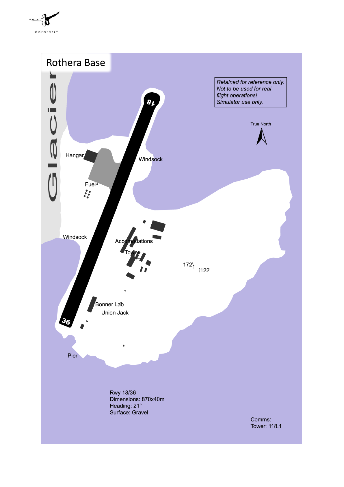
Limesim Antarctica X 1.00 Antarctica X 1.00 Manual
Page 45 of 59
Page 47

Limesim Antarctica X 1.00 Antarctica X 1.00 Manual
Page 46 of 59
Page 48

Limesim Antarctica X 1.00 Antarctica X 1.00 Manual
Page 47 of 59
Page 49

Limesim Antarctica X 1.00 Antarctica X 1.00 Manual
Page 48 of 59
Page 50

Limesim Antarctica X 1.00 Antarctica X 1.00 Manual
Page 49 of 59
Page 51

Limesim Antarctica X 1.00 Antarctica X 1.00 Manual
Page 50 of 59
Page 52

Limesim Antarctica X 1.00 Antarctica X 1.00 Manual
Page 51 of 59
Page 53

Limesim Antarctica X 1.00 Antarctica X 1.00 Manual
Page 52 of 59
Page 54

Limesim Antarctica X 1.00 Antarctica X 1.00 Manual
Page 53 of 59
Page 55

Limesim Antarctica X 1.00 Antarctica X 1.00 Manual
Page 54 of 59
Page 56

Limesim Antarctica X 1.00 Antarctica X 1.00 Manual
Page 55 of 59
Page 57

Limesim Antarctica X 1.00 Antarctica X 1.00 Manual
Page 56 of 59
Page 58

APPENDIX B LIST OF ALL BASES COVERED
ID
Name
Operator
Latitude
Longitude
Altitude
Surface
Dimensions
Heading
Approach
Tower
Sloped?
Detail
SAWB
Base Marambio
Argentina
64°14'18.71"S
56°37'42.99"W
600
Gravel
1250x40m
65
118.1
118.1
sloped
Medium
AQ10
Mawson/Rumdoodle Skiway
Australia
67°45'13.36"S
62°45'58.04"E
1,712
Slevelw/Ice
1000x40m
20
121.5
121.1
sloped
Medium
AQ07
Davis Plateau
Australia
68°28'20.14"S
78°50'22.66"E
1,582
Slevelw/Ice
1000x40m
80
121.5
121.1
sloped
Low
YWKS1
Casey Helipad
Australia
66°16'57.28"S
110°31'56.27"E
99
Metal
Helipad
121.1
level
High
YWKS2
Casey Emergency Helipad
Australia
66°16'56.34"S
110°31'31.46"E
117
Gravel
Helipad
121.5
level
High
YWKS
Casey Emergency Helipad
Australia
66°41'32.00"S
111°31'33.36"E
2,205
Slevelw/Ice
3200x80m
94.34
129.7
129.7
sloped
High
AQ17
Ulsteinen Airport (Princess-Elisabeth)
Belgium
71°57'1.88"S
23°16'7.90"E
4,160
Slevelw/Ice
1200x60m
90
118.1
sloped
Low
SCRM
Teniente R Marsh Martin
Chile
62°11'28.71"S
58°59'9.17"W
140
Gravel
1292x60m
116.85
119.7
118.1
sloped
Medium
AQ20
O'Higgins Skiway
Chile
63°19'38.99"S
57°50'34.99"W
649
Slevelw/Ice
800x40m
28
118.5
sloped
Medium
AQ02
Kunlun Airport
China
80°23'41.82"S
77° 2'58.19"E
13,262
Slevelw/Ice
2000x50m
120
130.1
sloped
Medium
AQ25
Dumont d'Urville D10 Skiway
France
66°42'17.45"S
139°49'17.11"E
720
Slevelw/Ice
1000x40m
338
121.5
125.4
sloped
Low
AQ37
D85 Skiway
France
70°25'30.02"S
134° 8'45.00"E
9,241
Slevelw/Ice
800x40m
140
133.7
sloped
Low
AQ30
Concordia Station - Dome C Skiway
France/Italy
75° 5'52.28"S
123°22'19.65"E
10,483
Slevelw/Ice
2740x60m
196/289
130.55
sloped
Medium
AQ41
Neumayer Station
Germany
70°40'59.39"S
8°17'11.24"W
49
Slevelw/Ice
1250x40m
108
123.45
sloped
High
AQ40
Kohnen Station
Germany
75° 0'4.01"S
0° 3'6.42"E
9,366
Slevelw/Ice
900x40m
65
123.45
sloped
Low
AQ38
Mid Point Skiway
Italy
75°32'26.76"S
145°49'7.26"E
10,483
Slevelw/Ice
1200x40m
16
125.8
sloped
Low
AQ39
Sitry Skiway
Italy
71°39'19.75"S
148°39'9.09"E
5,188
Slevelw/Ice
1000x40m
120
135.15
sloped
Low
NZTB
Mario Zuchelli Station Sea Ice Runways
Italy
74°41'16.55"S
164° 6'58.21"E
0
Slevelw/Ice
3250x60m
51/139/55
118.1
level
Medium
AQ34
Enigma Lake
Italy
74°42'57.33"S
164° 2'8.88"E
824
Slevelw/Ice
800x40m
34.6
132.875
sloped
Low
AQ33
Browning Pass
Italy
74°37'56.84"S
163°52'3.99"E
201
Slevelw/Ice
1260x40m
41.16
120.95
sloped
Low
AQ99
Dome Fuji
Japan
77°18'60.00"S
39°42'0.00"E
12,354
Slevelw/Ice
1200x40m
95
132.6
sloped
Low
AQ50
S17 Air Base Camp Skiway
Japan
69° 1'32.66"S
40° 6'30.28"E
2,010
Slevelw/Ice
1500x40m
95
130.6
sloped
Medium
NZWD1
Scott Helipad
New Zealand
77°50'54.79"S
166°46'20.10"E
28
Gravel
Helipad
126
level
High
AQ98
Troll Airfield
levelrway
71°57'25.30"S
2°27'13.68"E
3,911
Slevelw/Ice
3300x80m
69
128.1
sloped
Medium
AQ92
Mt. Vinson Base Camp
Private/Company
78°32'7.76"S
85°54'4.02"W
7,247
Slevelw/Ice
280x30m
80.2
sloped
Medium
Page 59

Limesim Antarctica X 1.00 Antarctica X 1.00 Manual
Page 58 of 59
SCGC
Union Glacier
Private/Company
79°46'39.75"S
83°19'9.02"W
2,383
Slevelw/Ice
3135x80m
39.95
131.325
sloped
Low
SCPZ
Patriot Hills
Private/Company
80°18'58.48"S
81°22'37.03"W
2,827
Slevelw/Ice
3000x80m
280.71
122.8
sloped
Medium
AQ45
levelvolasarevskaya (levelvo Air Base)
Russia
70°49'32.54"S
11°37'53.99"E
1,783
Slevelw/Ice
2980x80m
287.17
124.5
121.5
sloped
Medium
AQ60
Druzhnaya-4 Skiway
Russia
69°44'16.42"S
73°44'0.03"E
62
Slevelw/Ice
2000x60m
315
129.7
sloped
Low
AQ15
Progress Skiway
Russia
69°24'52.37"S
76°23'51.21"E
289
Unprepared
1000x40m
0
121.5
sloped
Low
AQ66
Vostok
Russia
78°28'4.63"S
106°50'28.82"E
11,180
Slevelw/Ice
3000x60m
35
124.5
121.5
sloped
Low
AQ70
Sanae IV Skiway
South Africa
71°40'1.20"S
2°45'56.54"W
2,581
Slevelw/Ice
1000x40m
340
123.45
sloped
High
AQ71
Sanae IV Helipad
South Africa
71°40'19.25"S
2°50'24.18"W
2,761
Slevelw/Ice
Helipad
123.45
level
High
AQ16
Wasa/Aboa Skiway
Sweden
73° 3'23.09"S
13°18'46.55"W
914
Slevelw/Ice
1200x40m
45
118.1
sloped
Low
EGAR
Rothera
United Kingdom
67°34'4.12"S
68° 7'38.62"W
13
Gravel
870x40m
21.13
118.1
level
High
AQ75
Rothera Emergency
United Kingdom
67°31'45.79"S
68°10'46.77"W
811
Slevelw/Ice
2340x40m
25.25
118.1
sloped
High
AQ80
Fossil Bluff Skiway
United Kingdom
71°19'45.60"S
68°16'2.00"W
316
Slevelw/Ice
1200x40m
353.25
118.1
sloped
Medium
AQ85
Sky Blu Runway
United Kingdom
74°51'25.57"S
71°34'9.21"W
4,447
Slevelw/Ice
900x40m
212.41
118.1
sloped
High
AQ90
Halley Station Skiway
United Kingdom
75°34'10.25"S
26°38'21.42"W
97
Slevelw/Ice
1112x40m
68.54
118.1
sloped
Medium
NZIR
McMurdo Ice Runway
USA
77°50'49.05"S
166°33'22.40"E
0
Slevelw/Ice
3048x80m
325.75
118.2
126.2
level
High
NZPG
McMurdo Pegasus Ice Runway
USA
77°57'53.00"S
166°31'1.00"E
0
Slevelw/Ice
3360x80m
340/274
118.2
130.5
level
High
NZWD
McMurdo Williams Field Skiway
USA
77°52'8.96"S
167° 3'35.72"E
0
Slevelw/Ice
3120x80m
160/259
118.2
126.2
level
High
NZIR1
McMurdo Heliport
USA
77°50'57.35"S
166°40'11.25"E
55
Gravel
Helipad
118.2
sloped
High
AQ88
CTAM Camp
USA
83°59'44.62"S
164°25'1.25"E
5,302
Slevelw/Ice
3335x80m
13.84
136.375
sloped
Low
AQ95
Siple Dome
USA
81°39'52.56"S
149° 0'44.02"W
1,994
Slevelw/Ice
3335x80m
26.44
118.4
sloped
Low
AQ89
Byrd Surface Camp
USA
80° 1'0.96"S
119°35'5.80"W
4,848
Slevelw/Ice
3335x80m
19.25
125.3
sloped
Low
AQ97
WAIS Divide
USA
79°28'25.01"S
112° 4'0.62"W
5,710
Slevelw/Ice
3335x80m
46.28
126.2
sloped
Low
 Loading...