

Page 1
www.vaisala.com
Three Dimensional Display for Radar Data
Vaisala IRIS 3D View
in 3D space. Users may dene from
1 to 4 iso-surfaces with respective to
color and opacity. Volume rendering
is where each data value is assigned a
color and displayed in 3D space. Both
display styles support changing the
viewing angle by panning, zooming,
and rotation. Animation of up to 24
hours of data is also supported from
a xed viewing angle.
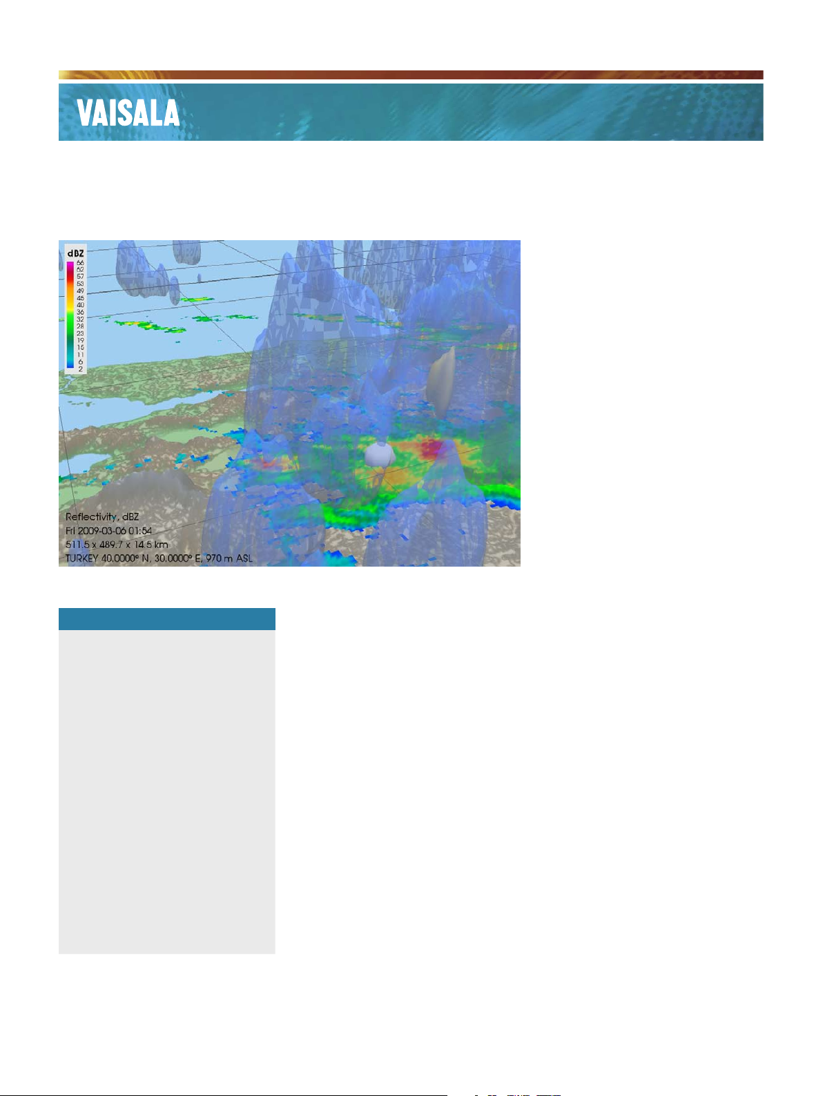
Digital elevation data may be used
within IRIS 3D View to show the
ground topography in 3D space.
This functionality allows comparison
of the relationships of radar data
to terrain. This is a useful feature
for studying weather patterns over
complex terrain or nding points of
beam blockage. IRIS 3D View also
supports displaying a traditional 2D
radar product as the base layer of
the presentation. This allows users
Features/Benefits
Reflectivity, Velocity, Spectrum
▪
Width, or Rain rate in
3 dimensions
Up to 4 iso-surfaces with
▪
adjustable opacity or volume
rendering
Pan, zoom, rotate, and
▪
animation
Interrogate radar data products
▪
using cursor tools
Display regional radar
▪
composites or single station
radar sites
2D radar products as underlays
▪
Geographical terrain in 3
▪
dimensions
Use in Live mode or search
▪
data archives
Weather radars generally
collect data using volume
scan strategies which provide
information on the angle,
distance, and height from the
radar site to a target. Vaisala’s
IRIS 3D View linux application
is for viewing and interacting
with this volumetric data in
three dimensions. 3D View
excels at creating 3D radar data
for operational diagnostics,
research and education, and
public outreach/presentations.
Explore, probe, and
dissect
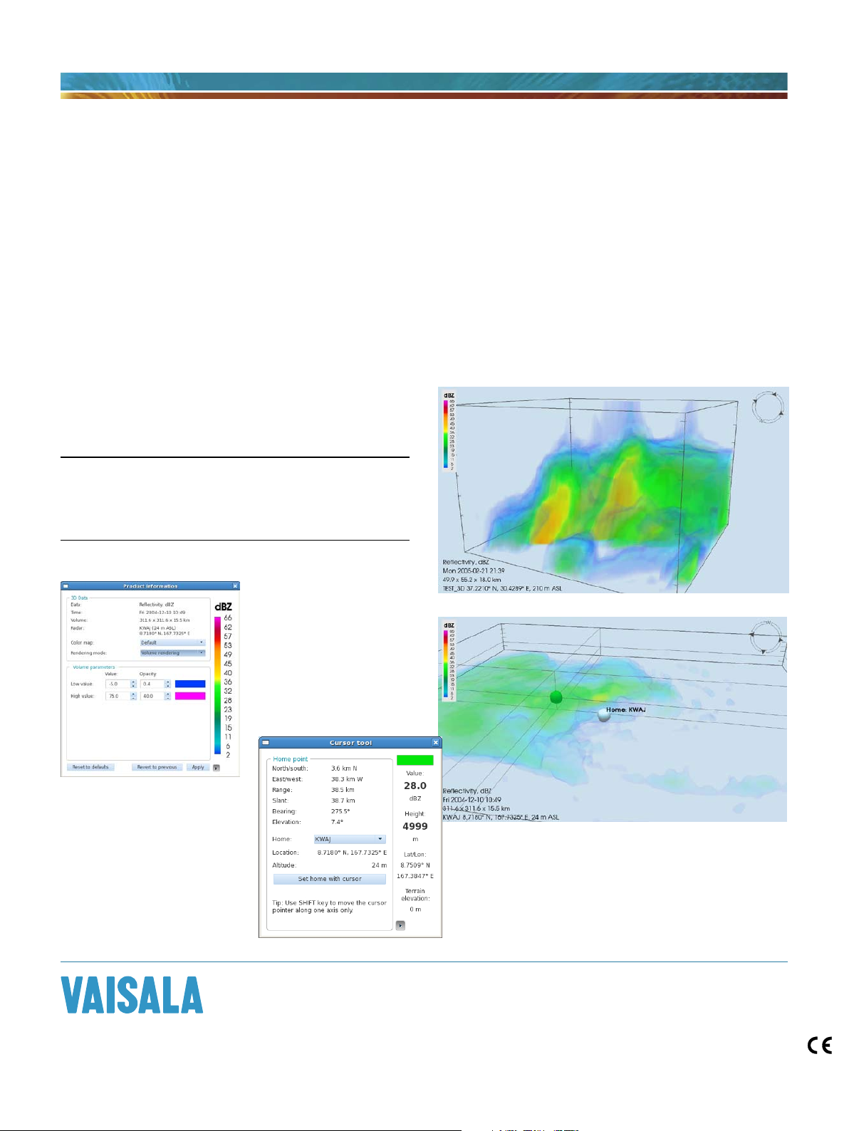
The IRIS 3D View application presents
radar volume information in three
dimensions. The three dimensional
information may be presented as
iso-surfaces or volume rendered.
An iso-surface display will show
locations of a constant data values
to compare information from the
traditional 2D products to that seen
in 3D. IRIS two- dimensional radar
products, such as PPI, CAPPI, MAX,
VIL, and SRI may be used as the 2D
layer. A cursor tool which can be
navigated in 3D space, presents the
data value, terrain height, latitude/
longitude position, plus range and
bearing to radar site or point of
interest.
In Live mode IRIS 3D View will
continuously present the newest
data in 3D space. When performing
research the application provides
an intuitive interface to search
archive data via radar site, date, and
time. Viewing angles and state may
be saved to the user preferences
for continuous use. For example, if
there is a particular ight corridor
a viewing angle may be saved in
IRIS 3D View which looks through
this corridor and presents the
information continuously.
Page 2
Comprehensive and User-Friendly
The IRIS 3D View interface was designed for both
novice and expert users. Existing technology, such as
Google Earth and Microsoft Visual Earth, were explored
for various methods commonly used to control 3D
environment. Throughout the design process usability
Technical data
Recommended Computer Requirements
Intel Core 2 Duo Processor (3.0 GHz) or equivalent
2GB RAM or greater
nVidia GeForce 9600 graphics accelerator card or equivalent
Red Hat Enterprise Linux 5.0 or greater
Minimum display resolution of 1280x1024
consultants were employed to evaluate the interface.
Test subjects with varied backgrounds provided
invaluable insight into their thought process while using
draft versions. These efforts have lead to an intuitive and
user-friendly experience within the complexity of working
in 3D space.
For more information, visit
www.vaisala.com or contact
us at sales@vaisala.com
Ref. B211057EN-A ©Vaisala 2010
This material is subject to copyright protection, with all
copyrights retained by Vaisala and its individual partners. All
rights reserved. Any logos and/or product names are trademarks
of Vaisala or its individual partners. The reproduction, transfer,
distribution or storage of information contained in this brochure
in any form without the prior written consent of Vaisala is strictly
prohibited. All specifications — technical included — are subject
to change without notice.
 Loading...