

Page 1

TomTom GO
Reference Guide
Page 2

Contents
Welcome to navigation with TomTom 5
Get going 6
Installing in your car ........................................................................................................................... 6
Positioning the device ........................................................................................................................ 6
Switching on and off .......................................................................................................................... 6
Setting up............................................................................................................................................ 7
GPS reception ..................................................................................................................................... 7
Planning a route using search ........................................................................................................... 7
Planning a route using the map ......................................................................................................... 9
Connecting to TomTom services 11
About TomTom services ................................................................................................................. 11
Always connected devices .............................................................................................................. 11
Smartphone connected devices ...................................................................................................... 11
Personal Area Networks ............................................................................................................. 12
Connect to TomTom services using your smartphone ............................................................. 12
Reconnecting your smartphone ................................................................................................. 12
Connect to TomTom services using a different smartphone ................................................... 13
Unable to get a connection ......................................................................................................... 13
My device 14
Memory card slot ............................................................................................................................. 14
Device not starting ........................................................................................................................... 14
Charging your device ....................................................................................................................... 14
Sending information to TomTom .................................................................................................... 14
Getting help ...................................................................................................................................... 15
Take care of your navigation device ............................................................................................... 15
What's on the screen 16
The map view ................................................................................................................................... 16
The guidance view ........................................................................................................................... 17
The route bar .................................................................................................................................... 19
Advanced Lane Guidance ................................................................................................................ 19
Using gestures 21
All about gestures ............................................................................................................................ 21
Main Menu 22
Navigation buttons ........................................................................................................................... 22
2
Page 3

Other buttons .................................................................................................................................... 23
Volume control ................................................................................................................................. 24
Using search 25
About search .................................................................................................................................... 25
Planning a route using search ......................................................................................................... 25
Entering search criteria .................................................................................................................... 27
Working with search results ............................................................................................................ 28
Planning a route 30
Planning a route using search ......................................................................................................... 30
Planning a route using the map ....................................................................................................... 31
Planning a route using My Places ................................................................................................... 33
Finding a car park ............................................................................................................................. 34
Finding a petrol station .................................................................................................................... 36
Changing your route 38
The Current Route Menu.................................................................................................................. 38
Types of route .................................................................................................................................. 39
Route features .................................................................................................................................. 39
Add a stop to your route from the current route menu ................................................................. 39
Add a stop to your route using the map ......................................................................................... 39
Delete a stop from your route ......................................................................................................... 40
Traffic 41
About TomTom Traffic ..................................................................................................................... 41
Safety Notice .................................................................................................................................... 41
The route bar .................................................................................................................................... 42
Looking at traffic on the map ........................................................................................................... 42
Looking at traffic on your route ....................................................................................................... 43
Traffic incidents ................................................................................................................................ 44
Speed Cameras 46
About speed cameras ...................................................................................................................... 46
Speed camera warnings .................................................................................................................. 46
Changing the way you are warned - speed cameras ..................................................................... 47
Speed camera symbols.................................................................................................................... 47
Danger Zones 49
About danger zones ......................................................................................................................... 49
Danger zone warnings ..................................................................................................................... 49
Changing the way you are warned .................................................................................................. 50
Danger zone symbols....................................................................................................................... 50
3
Page 4

My Places 51
About My Places............................................................................................................................... 51
Set your home location .................................................................................................................... 51
Change your home location ............................................................................................................ 52
Add a location from My Places ........................................................................................................ 52
Add a location to My Places from the map ..................................................................................... 52
Add a location to My Places using Search ...................................................................................... 53
Delete a recent destination from My Places ................................................................................... 53
Delete a location from My Places .................................................................................................... 54
Settings 55
Appearance ....................................................................................................................................... 55
Brightness .................................................................................................................................... 55
Destination panel ......................................................................................................................... 56
Voices ................................................................................................................................................ 56
Maps.................................................................................................................................................. 57
Route planning ................................................................................................................................. 57
Sounds and Warnings ...................................................................................................................... 58
Speed camera warnings ............................................................................................................. 58
Safety warnings ........................................................................................................................... 59
Language and Units.......................................................................................................................... 59
System .............................................................................................................................................. 60
Help ................................................................................................................................................... 60
Help 62
Help menu options ........................................................................................................................... 62
MyTomTom 63
About MyTomTom ........................................................................................................................... 63
MyTomTom account ........................................................................................................................ 63
Setting up MyTomTom .................................................................................................................... 63
Addendum 65
Copyright notices 72
4
Page 5

This Reference Guide explains all you need to know about your new TomTom GO navigation de-
Welcome to navigation with TomTom
vice.
If you want a quick read of the essentials, we recommend that you read the Get going chapter.
This covers installation, switching on, setting up and planning your first route.
After that, you will probably want to connect to TomTom services and you can read all about that
in the Connecting to services chapter.
For information about what you see on the device itself, go to:
What's on the screen
Using gestures
Main Menu
We hope you enjoy reading about and, most importantly, using your new navigation device!
5
Page 6

Installing in your car
Get going
Use the mount provided with your device to install your TomTom GO device in your vehicle. Read
the instructions about positioning your device before you install your device.
To install your device, do the following:
1. Connect the USB cable to the mount. If the mount is integrated into your device, connect the
USB cable to the device.
2. Connect the USB cable to the USB car charger and plug this into the power supply on your
dashboard.
3. Choose the best smooth location, on your windscreen or side window, to mount your
TomTom GO device.
4. Make sure that both the suction cup on the mount and your windscreen are clean and dry.
5. Press the suction cup of the mount firmly against your windscreen.
6. Turn the rubber grip near the base of the mount in a clockwise direction until you feel it lock.
7. If your mount is not integrated into your device, place your device in the mount, making sure
that it clicks into place.
Dashboard mount disks are available as part of a range of accessories for your device. For more
information, go to tomtom.com/accessories.
Positioning the device
Be careful where you install your navigation device in your car. The device shouldn't block or interfere with any of the following:
Your view of the road
Any of the controls in your car
Any of the mirrors
Any airbags
You should be able to reach the device easily without leaning or stretching. You can attach the
device to the windscreen or side window or you can use a Dashboard Mount Disk to attach the
mount to your dashboard.
Switching on and off
Switching your device on
Press the On/Off button until your device starts. If the device was off you see the map view. If your
device was sleeping you see the last screen you were looking at.
Sending your device to sleep
To send your navigation device to sleep, press the On/Off button and then release it.
6
Page 7
You can also press the On/Off button for more than 2 seconds until you see the Sleep and Turn
Off buttons. Select Sleep to make the device sleep.
Note: If you have planned a route, the route is saved.
Tip: To send your navigation device to sleep when it is removed from the mount, go to Battery
settings in the Settings Menu.
Switching your device off completely
To switch off your navigation device completely, you can do one of the following:
Press and hold the On/Off button for more than 2 seconds until you see the Sleep and Turn Off
buttons. Select Turn Off to switch off the device. Select the "back" button if you don't want to
switch your device off.
Press and hold the On/Off button for more than 5 seconds until the device switches off.
Note: If you have planned a route, the route is not saved.
Setting up
Important: Take care to select the correct language as the language you choose will be used for
all text on the screen.
When you first switch on your device, you have to answer a few questions to set up the device.
Answer the questions by touching the screen.
GPS reception
When you first start your TomTom GO navigation device, the device may need a few minutes to
determine your position. In future, your position will be found much faster.
To ensure good satellite reception, use your device outdoors and keep it upright. Large objects
such as tall buildings can sometimes interfere with reception.
Important: QuickGPSfix contains information about satellite positions which helps your navigation
device find your position faster. To get QuickGPSfix, use MyTomTom.
Planning a route using search
Important: In the interest of safety and to reduce distractions while you are driving, you should
always plan a route before you start driving.
To plan a route using search, do the following:
1. Select the Main Menu button to open the Main Menu:
2. Select Search.
7
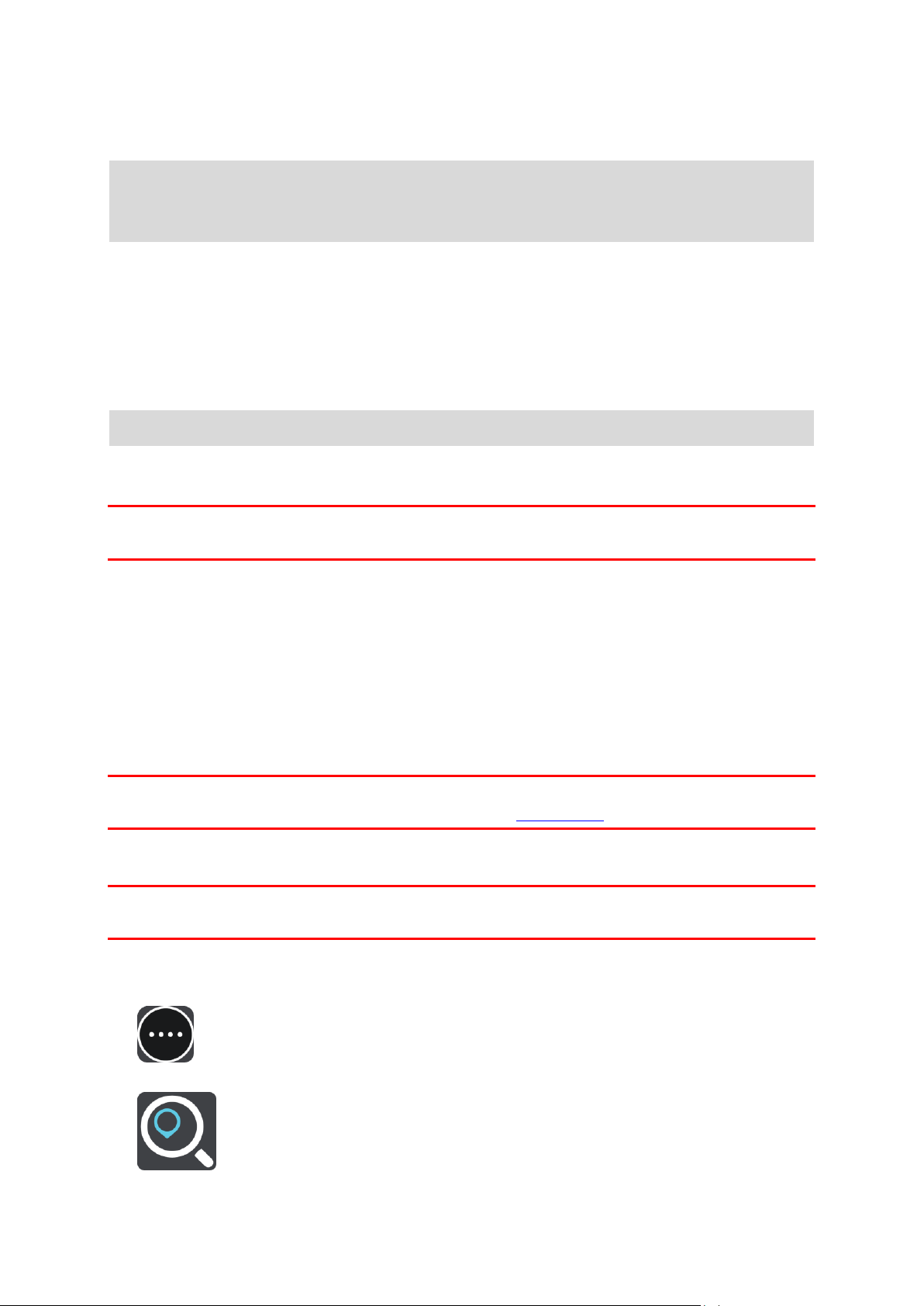
Page 8
The search screen opens with the keyboard showing.
3. Use the keyboard to enter the name of the place you want to plan a route to.
You can search for an address but you can also search for a town, city or postcode. In addition
you can search for a POI (Point of Interest), such as a restaurant, petrol station or tourist attraction or you can enter the name of a specific POI, for example, "Rosie's Pizzeria".
Note: When searching, the whole map is searched. If you want to change how the search is
done, select the button to the right of the search box. You can then change where the search
is carried out, for example, to being along the route or in a city.
4. As you type the address, name or type of POI suggestions are shown based on what you have
entered. You can continue typing or select a suggestion.
Towns and roads are shown on the left, POIs are shown on the right.
Tip: To see more results, select Show all or swipe the results list to scroll it.
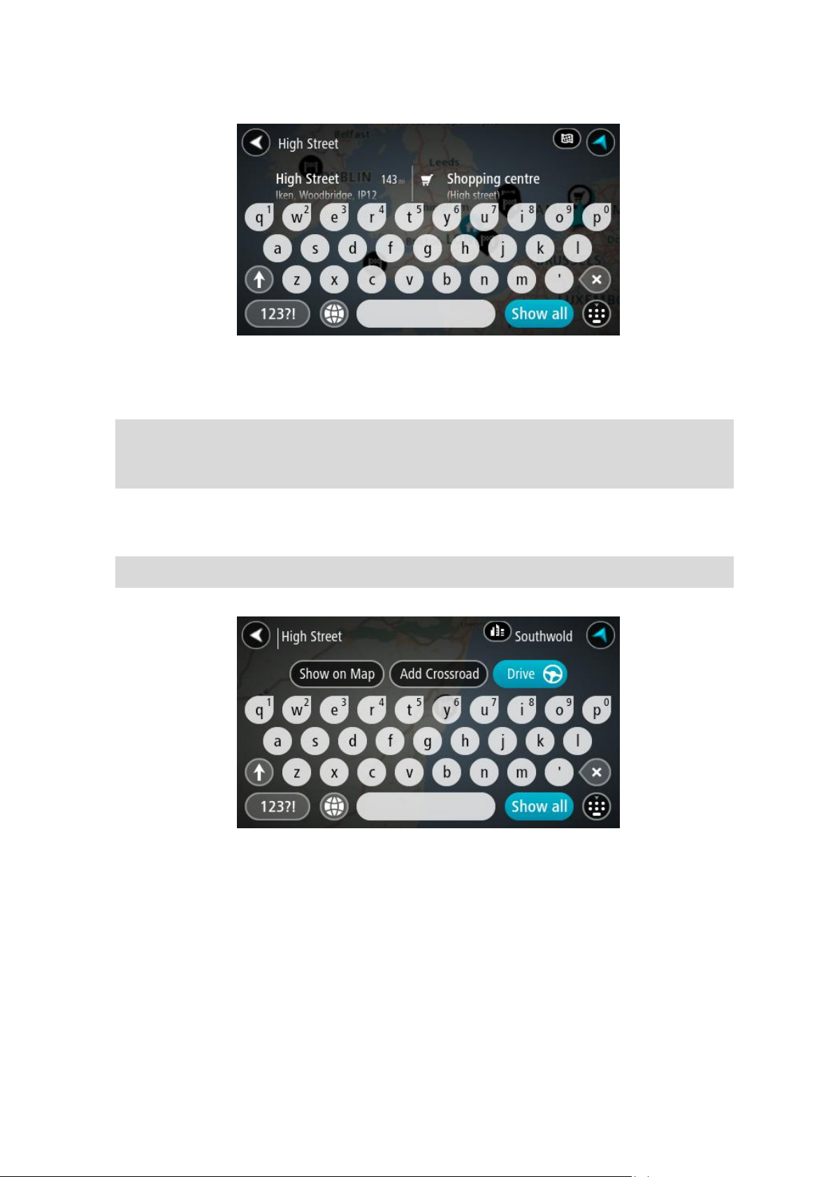
5. Select an address suggestion.
8
Page 9
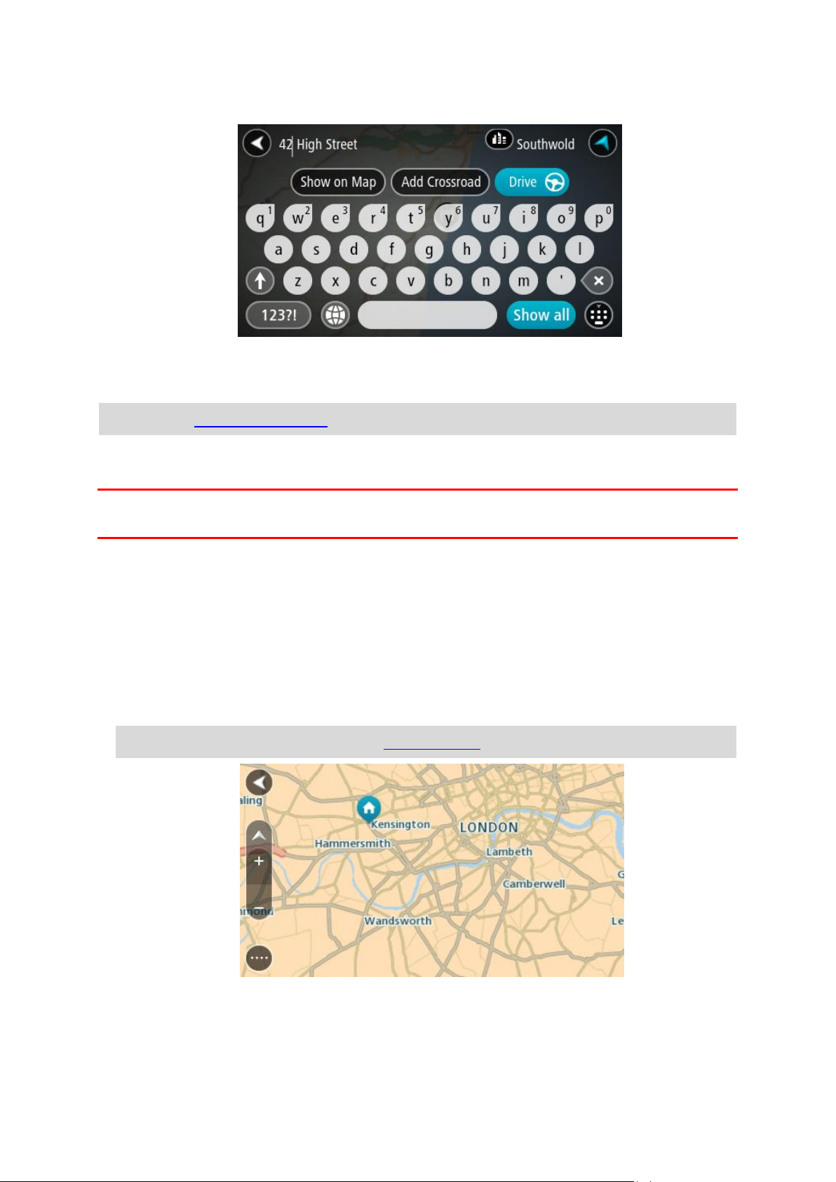
6. If you haven't already entered a house number, you can do it now if you have one.
7. Select Drive.
Your navigation device plans a route then starts to guide you to your destination. As soon as
you start driving, the guidance view is shown automatically.
Tip: You can add a stop to a route that you have already planned.
Planning a route using the map
Important: In the interest of safety and to reduce distractions while you are driving, you should
always plan a route before you start driving.
To plan a route using the map, do the following:
1. Move the map until you can see the destination that you want to navigate to. Here are some of
the gestures you can use to move the map:
Pinch - to zoom, touch the screen with your thumb and a finger. Move them apart to zoom
in or move them together to zoom out.
Double tap - to zoom in, double tap on the map.
Drag - to scroll the map, touch the screen with a finger and move it across the screen.
Flick - to scroll the map a long way, flick the tip of a finger across the screen.
Tip: For a complete list of gestures, see Using gestures.
.
2. When you have found your destination on the map, select it by pressing and holding the
screen for about one second.
9
Page 10
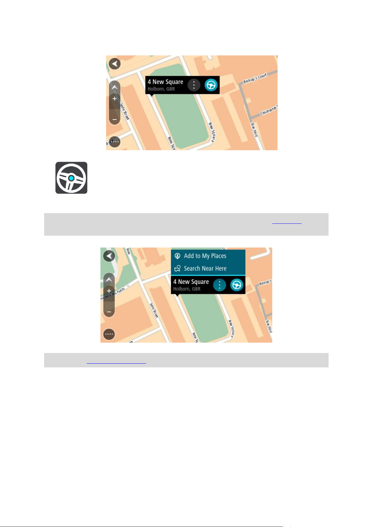
A pop-up menu shows the nearest address.
3. To plan a route to this destination, select the drive button:
Your navigation device plans a route then starts to guide you to your destination. As soon as
you start driving, the guidance view is shown automatically.
Tip: You can use the location you selected in other ways, such as adding it to My Places, by
selecting the pop-up menu button.
Tip: You can add a stop to a route that you have already planned.
10
Page 11

About TomTom services
Connecting to TomTom services
TomTom services give you real-time information about traffic and speed cameras on your route.
To get TomTom services on your GO you need a MyTomTom account.
The way you connect your GO to TomTom services depends on your navigation device. A GO can
connect in one of the following ways:
With a permanent connection directly from your GO. These navigation devices are called 'Al-
ways Connected' devices.
With a connection via your smartphone. These devices are called 'Smartphone Connected'
devices.
Check tomtom.com/connect for more information.
Note: TomTom services are not available in all countries or regions, and not all services are
available in all countries or regions. You may be able to use TomTom services when travelling
abroad. For more information on available services, go to tomtom.com/services.
Always connected devices
Follow these steps to get TomTom services on a TomTom GO that is always connected.
1. Select Traffic and Speed Cameras or Traffic and Danger Zones in the Main Menu.
2. Select Yes to agree to send information to TomTom.
Note: You cannot use TomTom services unless you agree to send information to TomTom.
3. Follow the on-screen instructions to start using TomTom services.
Note: You need to open a MyTomTom account before you can use TomTom services on your
device. For more information, go to tomtom.com/getstarted.
Smartphone connected devices
Some TomTom navigation devices use your phone to connect to TomTom services so that you
can receive real-time TomTom Traffic and safety warnings. Your phone needs to be compatible
with the navigation device, and you must have a data plan from a mobile services provider. Go to
tomtom.com/connect for more information.
Using TomTom services means that data is sent and received by your phone using your mobile
services provider.
Important: You might have additional costs when you use the internet on your phone, especially
if you are outside the area covered by your data plan. Check with your mobile services provider
for more information.
11
Page 12

Personal Area Networks
Your phone shares its internet connection by using the phone's Bluetooth and Personal Area
Network (PAN) functions.
Depending on your phone's Operating System, this network, or PAN, might be called one of the
following names:
Personal Hotspot
Tethering or Bluetooth Tethering
Tether or Bluetooth Tether
The PAN function is probably already in your phone's Operating System, or you can download an
app to create a PAN.
Note: Some mobile service providers don't allow their users to use a PAN. If your phone
doesn't have the PAN function, you should contact your service provider for more information.
Please check the user guide for your phone if you are having trouble finding the settings.
For more help, go to tomtom.com/connect.
Connect to TomTom services using your smartphone
To connect your GO to your phone, do the following:
1. Select Traffic and Speed Cameras or Traffic and Danger Zones in the Main Menu.
2. Select Try them now.
3. Select Yes to agree to send information to TomTom.
Note: You cannot use TomTom services unless you agree to send information to TomTom.
4. Follow the instructions on your navigation device about switching on a Personal Area Network
on your smartphone.
5. Switch on Bluetooth on your phone, and make sure your phone is discoverable.
6. Select the next screen arrow on your navigation device.
Your device searches for your phone.
Tip: If your device cannot find your phone, make sure your phone is still 'discoverable' for
other Bluetooth devices. Select Search to search for your phone again.
7. Select your phone from the list on your navigation device.
Your navigation device connects to TomTom services using your phone's internet connection.
8. Follow the on-screen instructions to get TomTom services.
Reconnecting your smartphone
You do not need to do anything to reconnect your GO to your phone.
Your GO will remember your phone and will find it automatically when you have Personal Area
Network (PAN) and Bluetooth switched on and you are in range of your navigation device. If you
have a valid TomTom services subscription, the service will start automatically.
The Bluetooth icon at the top of the main menu screen shows the status of the Bluetooth connection:
12
Page 13

Bluetooth not connected.
Bluetooth connecting. Your device is trying to automatically connect to
your phone.
Bluetooth connected. Your device is connected to your phone.
If you want to connect using another phone, you must turn on Personal Area Network (PAN) and
Bluetooth on that phone, then let your device search for the phone.
Connect to TomTom services using a different smartphone
1. Select Traffic and Speed Cameras or Traffic and Danger Zones in the Main Menu.
2. Select Manage phones.
3. Follow the instructions on your device about switching on a Personal Area Network on your
smartphone.
4. Switch on Bluetooth on your smartphone.
5. Select Search Again.
Your navigation device searches for your smartphone.
Tip: If your device cannot find your smartphone, make sure your smartphone is still 'discoverable' for other Bluetooth devices.
6. Select your smartphone from the list of smartphones on your device.
Your navigation device connects to TomTom services using your smartphone internet connection.
7. Follow the on-screen instructions to start using TomTom services.
Unable to get a connection
If your GO cannot connect to your phone, or you have no internet connection, check the following:
Your phone is shown on your TomTom navigation device.
Your phone's Bluetooth is switched on.
Your phone's Personal Area Network (PAN), which is also known as Personal Hotspot, Tether-
ing, or Bluetooth Tethering, is switched on.
Your data plan with your mobile services provider is active, and you can access the internet
on your phone.
13
Page 14

Memory card slot
My device
Some TomTom navigation devices have a memory card slot that is located on the side or bottom
of the device.
Before you use the memory card slot, make sure that you have the latest version of the application
installed on your navigation device by connecting to MyTomTom using a computer.
When your device is up-to-date, you can use a memory card as extra storage space to add extra
maps to your device. Maps can be purchased from tomtom.com.
Device not starting
In rare cases, your TomTom GO navigation device may not start correctly or may stop responding
to your taps.
First, check that the battery is charged. To charge the battery, connect your device to the car
charger. It can take up to 2 hours to fully charge the battery.
If this does not solve the problem, you can reset the device. To do this, press and hold the On/Off
button until your device begins to restart.
Charging your device
The battery in your TomTom GO navigation device charges when you connect it to the car
charger or to your computer.
You are warned when the battery level is low or critical. When the battery is empty, the device
goes into sleep mode.
If your device gets hot while connected to the car charger, the battery cannot charge. Once the
device cools down, it starts to charge again.
Important: You should plug the USB connector directly into a USB port on your computer and not
into a USB hub or USB port on a keyboard or monitor.
Sending information to TomTom
When you first start navigating or perform a reset, your device asks for permission to collect some
information about your use of the navigation device. The information is stored on the device until
we retrieve it. We use it anonymously to improve our products and services. If you use our services, we will also use your location information to deliver the services to you.
You can change whether you share this information with us at any time by doing the following:
1. In the Main Menu, select Settings.
2. Select System.
3. Select Your information.
14
Page 15

4. Select the button to turn sending of information on or off.
Note: If you choose not to share this information, you will no longer receive our services. This
is because services need to send the location of your device to TomTom in order to receive the
traffic information related to where you are. The end date of your subscription remains the
same, even if you do not share this information with us.
Additional information
If you think that your information is not being used for the purpose for which you have provided it
to TomTom, contact us at tomtom.com/support.
You can find current and more detailed information at tomtom.com/privacy.
Getting help
You can get further help by going to tomtom.com/support.
For warranty and privacy information, go to tomtom.com/legal.
Take care of your navigation device
It is important to take care of your device:
Do not open the casing of your device under any circumstances. Doing so may be dangerous
and will invalidate the warranty.
Wipe or dry the screen of your device using a soft cloth. Do not use any liquid cleaners.
15
Page 16
The map view
What's on the screen
The map view is shown when you start your navigation device and you have no planned route.
Your actual location is shown as soon as your device has found your GPS location.
You can use map view in the same way as you might look at a traditional paper map. You can
move around the map using gestures, and zoom using the zoom buttons.
The map shows your current location and many other locations such as your My Places locations.
If you have not planned a route the map is zoomed out to show the area around your location. If
you have planned a route, your complete route is shown on the map. You can add stops to your
route directly from the map.
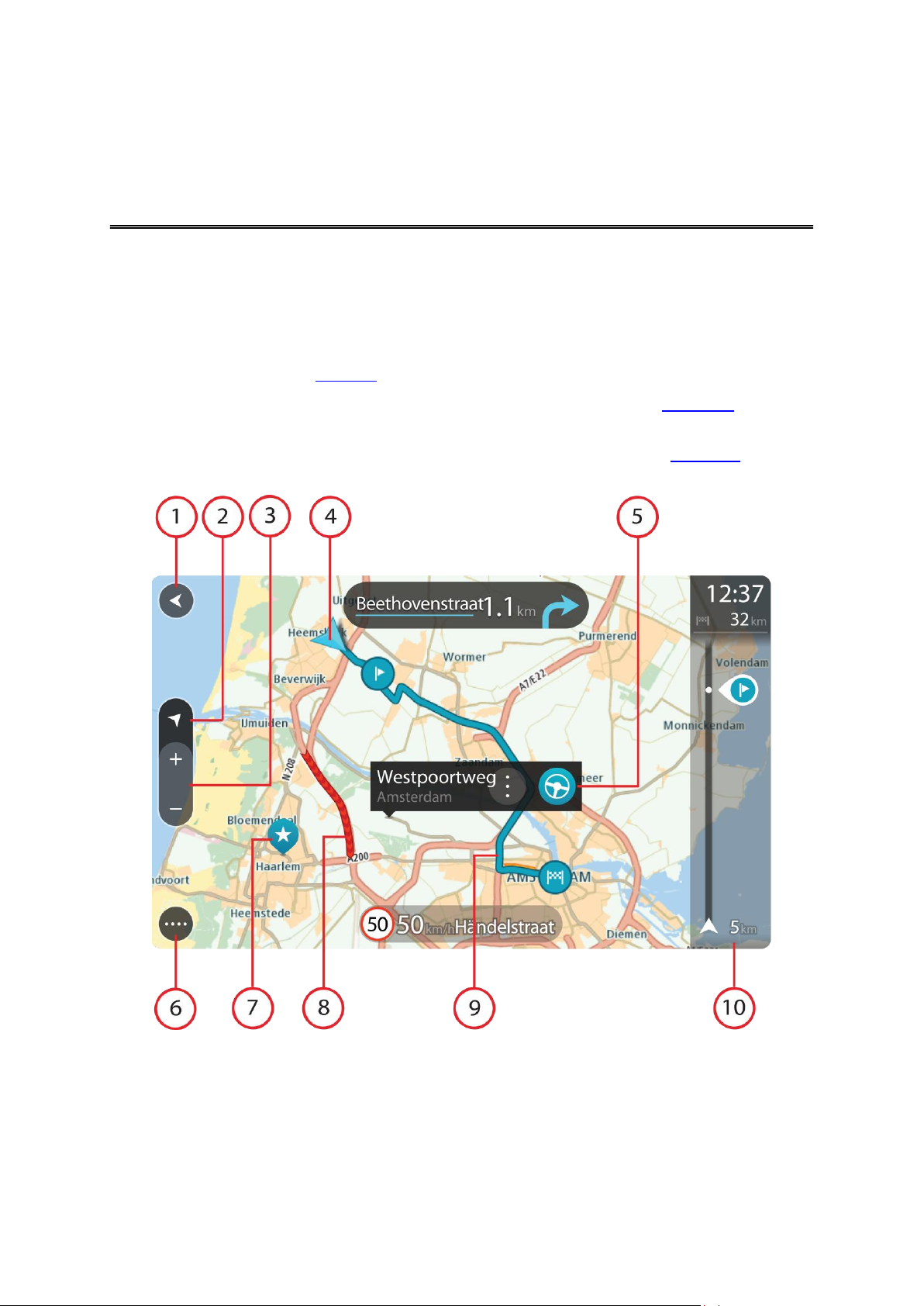
1. Back button. This button returns the map to an overview of your whole route or, if no route is
planned, moves the map to put your current location at the centre.
2. Switch view button. Select the switch view button to change between the map view and the
guidance view.
3. Zoom buttons. Select the zoom buttons to zoom in and out.
4. Current location. This symbol shows your current location.
16
Page 17
5. Selected location. Press and hold to select a location on the map. Select the pop-up menu
button to show options for the location, or select the drive button to plan a route to the location.
6. Main Menu button. Select the button to open the Main Menu.
7. Map symbols. Symbols are used on the map to show your destination and your saved places:
Your destination.
Your home location. You can set your home location in My Places.
A stop on your route.
A location saved in My Places.
8. Traffic information. Select the traffic incident to display information about the traffic delay.
9. Your route, if you have planned a route.
10. Route bar. The route bar is shown when you have planned a route.
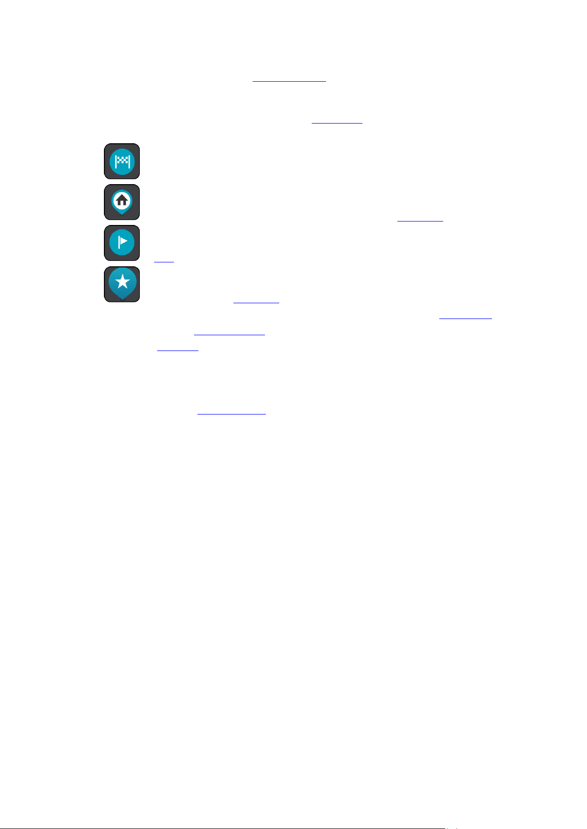
The guidance view
The guidance view is used to guide you along the route to your destination. The guidance view is
normally in 3D, but you can change it to 2D.
The guidance view is shown when you start driving. You see your current location and details
along your route, including 3D buildings in some cities.
17
Page 18
When your navigation device starts after it was turned off and you have a route planned, you are
shown the map view with your current location.
1. Switch view button. Select the switch view button to change between the map view and the
guidance view.
2. Zoom buttons. Select the zoom buttons to zoom in and out.
3. Instruction panel. This panel shows the following information:
The direction of your next turn.
The distance to your next turn.
The name of the next road on your route.
Lane guidance at some junctions.
4. Route symbols. Symbols are used on your route to show your starting location, your stops,
and your destination.
5. Main Menu button. Select the button to show the Main Menu.
6. Speed panel. This panel shows the following information:
The speed limit at your location.
Your current speed.
The name of the street you are driving on.
7. Current location. This symbol shows your current location.
8. Route bar. The route bar is shown when you have planned a route.
18
Page 19
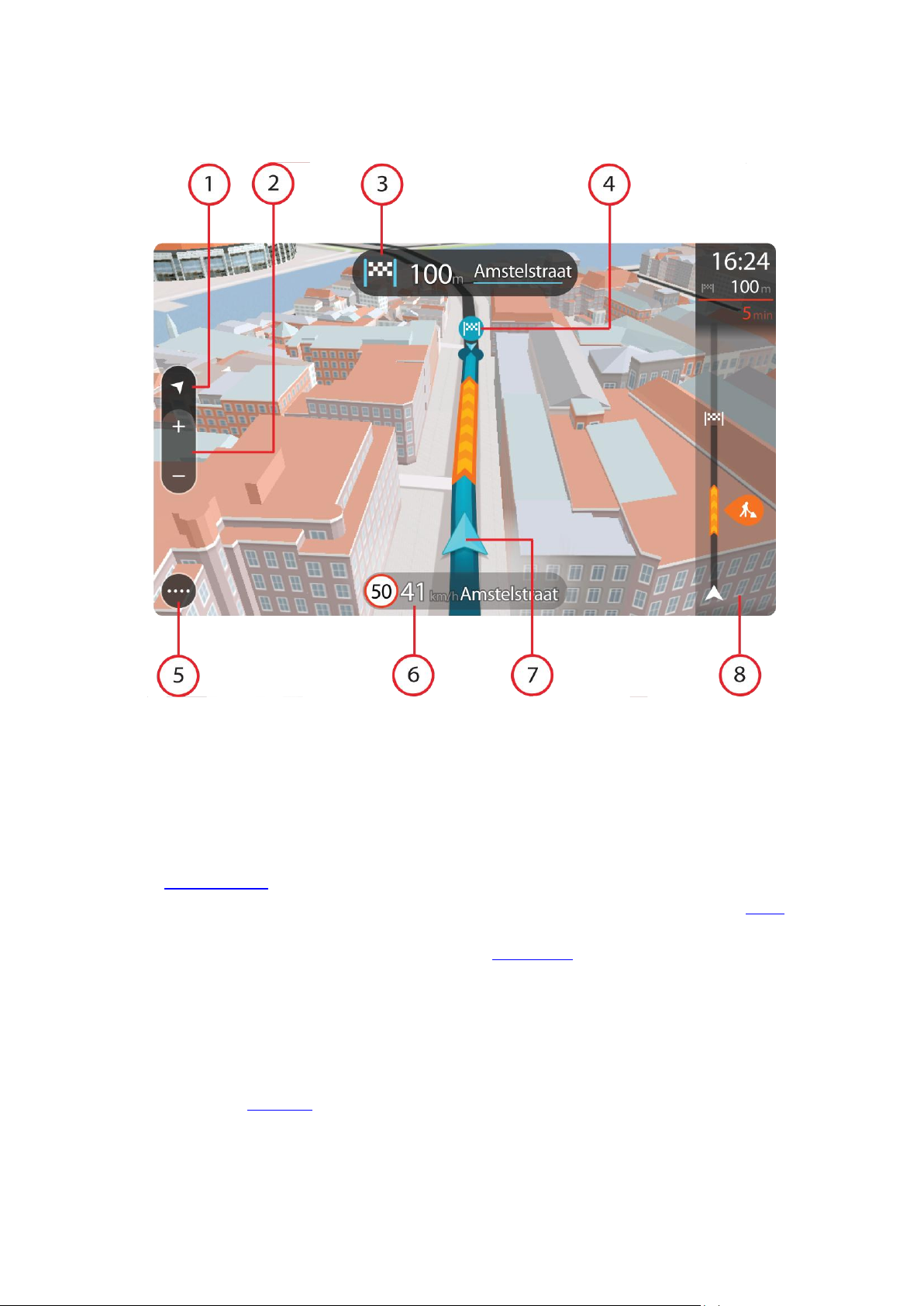
The route bar
The destination panel shows the following information:
The estimated time that you will arrive at your destination.
The length of time to drive to the destination from your current
location.
The distance to your destination from your current location.
If you have stops on your route, select this panel to change between information about the next stop and your final destination.
You can choose the information you see on the destination panel.
The bar uses symbols to show the following information:
Stops on your route.
Petrol stations that are directly on your route.
TomTom Traffic.
TomTom Speed Cameras and Danger Zones.
The symbols are in the order that they occur on your route. For
traffic incidents, the symbol for each incident alternates between
showing the type of incident and the delay in minutes. Select a
symbol to see more information about a stop or an incident.
The total time delay due to traffic jams and other incidents on your
route, including information provided by IQ Routes, is shown
above the symbols.
For a complete list of incident types, see Traffic incidents.
The bottom of the route bar represents your current location and
shows the distance to the next incident on your route.
The route bar is shown when you have planned a route. It has a destination panel at the top, and a
bar with symbols underneath.
Tip: To make the route bar more readable some incidents may not be shown. These incidents
will always be of minor importance and only cause short delays.
The route bar also shows messages about the status of your GO.
Advanced Lane Guidance
Note: Lane guidance is not available for all junctions or in all countries.
Your TomTom GO navigation device helps you prepare for motorway exits and junctions by
showing the correct driving lane for your planned route.
19
Page 20
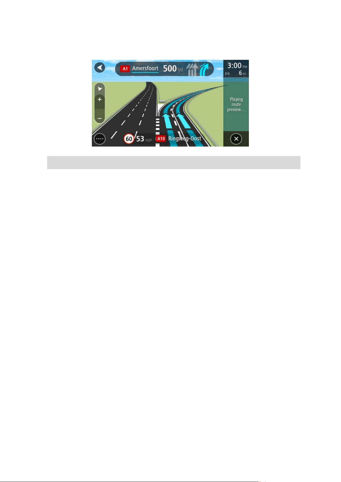
As you approach an exit or junction, the lane you need is shown on the screen and in the instruction panel.
Tip: To close the lane image, select anywhere on the screen or press the back button.
To turn lane images off, select Settings in the Main Menu, then select Appearance. Switch off
the Show previews of motorway exits setting.
20
Page 21
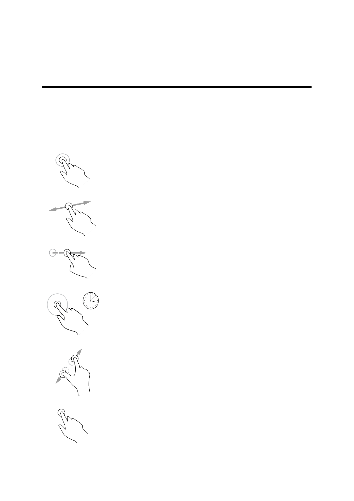
All about gestures
Double tap
Touch one finger on the screen twice in rapid succession.
Example of when to use this: Zooming in on the map.
Drag
Put one finger on the screen and move it across the screen.
Example of when to use this: Scrolling around in the map.
Flick
Flick the tip of a single finger across the screen.
Example of when to use this: Scrolling a big distance on the map.
Long press
Put one finger on the screen for more than 0.5 second.
Example of when to use this: Opening the pop-up menu for a place on
the map.
Pinch
Touch the screen with your thumb and a finger. Move them apart to
zoom in or move them together to zoom out.
Example of when to use this: Zooming in and out on the map.
Tap or select
Tap a single finger on the screen.
Example of when to use this: Selecting an item in the Main Menu.
Using gestures
You need to use gestures to control your navigation device.
This Reference Guide explains which gestures to use throughout the guide but here is a complete
list of all the gestures you can use.
21
Page 22
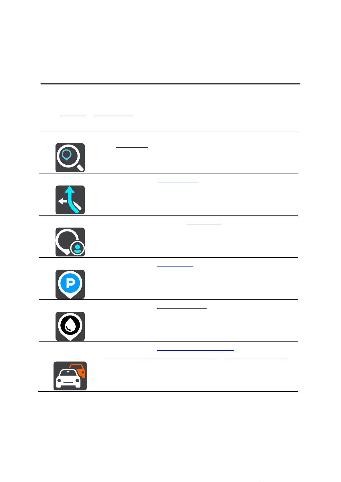
Navigation buttons
Search
Select this button to search for an address, a place or a Point of Interest,
then plan a route to that location.
Current route
Select this button to clear or change your planned route.
My Places
Select this button to show your saved places.
Parking
Select this button to find car parks.
Petrol Station
Select this button to find petrol stations.
Traffic and Safety
Warnings
Select this button to connect to TomTom services, or to check your
TomTom Traffic, TomTom Speed Cameras or TomTom Danger Zones
subscription.
Main Menu
On the map view or guidance view, select the Main Menu button to open the Main Menu.
The following navigation buttons are available in the Main Menu:
22
Page 23

Other buttons
Select this button to open the Settings Menu.
Select this button to open the Help Menu. The Help Menu contains a
guided tour and information about your GO.
Select this button to return to the previous screen.
This symbol shows the status of the Bluetooth connection when you use
a smartphone to connect to TomTom services.
This symbol shows the power level of the battery in your device.
Select this button to return to the map view or guidance view.
Select this button to switch off voice instructions. You will no longer hear
spoken route instructions but you will still hear information such as traffic
information and warning sounds.
Tip: You can select the types of instructions you want to hear. Select
Voices in the Settings Menu and select the instructions you want to
hear.
Select this button to switch on voice instructions.
Select this button to reduce the brightness of the screen and display the
map in darker colours.
When driving at night or when driving through a dark tunnel, it is easier
to view the screen and less distracting for the driver if the brightness of
the screen is dimmed.
Tip: Your device automatically switches between day and night colours depending on the time of day. To switch off this feature, select
Appearance in the Settings menu and switch off Switch to night col-
ours when dark.
On the map or guidance view, select the Main Menu button to open the Main Menu.
The following buttons are available in the Main Menu screen, in addition to the navigation buttons:
23
Page 24

Select this button to increase the brightness of the screen and display the
map in brighter colours.
Volume control
On the map or guidance view, select the Main Menu button to open the Main Menu.
Select and slide the volume control to change the volume of voice instructions and warnings. If
the voice instructions are switched off, the volume control will still change to volume of the warnings.
24
Page 25

About search
Using search
To find a wide range of places and then navigate to them, you use search. Using search you can
do the following:
Search for a specific address, for example, 123 Oxford Street, London.
Search for a partial address, for example, Oxford st Lon.
Search for a type of place, for example, petrol station, restaurant.
Search for a place by name, for example, Starbucks.
Search for a postcode, for example, W1D 1LL for Oxford Street, London.
Search for a city to navigate to a city centre, for example, London.
Search for a POI (Point of Interest) near your current location, find example, find a restaurant
near me.
Planning a route using search
Important: In the interest of safety and to reduce distractions while you are driving, you should
always plan a route before you start driving.
To plan a route using search, do the following:
1. Select the Main Menu button to open the Main Menu:
2. Select Search.
The search screen opens with the keyboard showing.
3. Use the keyboard to enter the name of the place you want to plan a route to.
25
Page 26

You can search for an address but you can also search for a town, city or postcode. In addition
you can search for a POI (Point of Interest), such as a restaurant, petrol station or tourist attraction or you can enter the name of a specific POI, for example, "Rosie's Pizzeria".
Note: When searching, the whole map is searched. If you want to change how the search is
done, select the button to the right of the search box. You can then change where the search
is carried out, for example, to being along the route or in a city.
4. As you type the address, name or type of POI suggestions are shown based on what you have
entered. You can continue typing or select a suggestion.
Towns and roads are shown on the left, POIs are shown on the right.
Tip: To see more results, select Show all or swipe the results list to scroll it.
5. Select an address suggestion.
6. If you haven't already entered a house number, you can do it now if you have one.
7. Select Drive.
Your navigation device plans a route then starts to guide you to your destination. As soon as
you start driving, the guidance view is shown automatically.
Tip: You can add a stop to a route that you have already planned.
26
Page 27

Entering search criteria
Current map
Select this option to search the whole of your current map with no
limit to the search radius. Your current location is the centre of the
search. The results are ranked by exact match.
Near me
Select this option to search with your current GPS location as the
search centre. The results are ranked by distance.
In town or city
Select this option to use a town or city as the centre for your search.
You need to enter the town or city name using the keyboard.
Along route
When a route has been planned, you can select this option to search
along your route for a specific type of location, for example, petrol
Select Search in the Main Menu to start searching for addresses and POIs. The search screen
opens showing the keyboard and the following buttons:
1. Back button.
Select this button to go back to the previous screen.
2. Search input box.
As you enter search criteria, hints are shown to help you and then suggestions are shown.
3. Type of search.
By default, the whole of the current map is searched. Select this button to change the type of
search to any of the following:
27
Page 28

stations. When prompted, enter the type of location and then select it
in the right-hand column to carry out the search.
Near destination
When a route has been planned, you can select this option to use
your destination as the centre for your search.
4. View button.
Select this button to return to the map view or guidance view.
5. Show all button.
Select this button to hide the keyboard and show the list of results.
6. Show keyboard.
Select this button to show or hide the keyboard.
Tip: To cancel a search, select the map/guidance view button in the top right-hand corner of the
screen.
Working with search results
After carrying out a search, you see your search results in two columns.
Address and city matches are shown in the left-hand column and POIs, Places and location type
suggestions are shown in the right-hand column.
Tip: Select the Show all button to close the keyboard.
Tip: You can scroll down the list of results using the scroll bar on the right hand side of the
second column.
28
Page 29

When you select an address from the list of search results, you can choose to show it on the map,
add a crossroad or plan a route to that chosen location.
If you show the result on the map, you can use the pop-up menu to add the location to My Places
or search near this location. If a route is already planned, you can add the location to your current
route.
Note: From the list of search results, you can also show the results on the map by selecting this
button:
The best search results are shown on the map. When you zoom in, the lower ranked search results are gradually shown.
29
Page 30

Planning a route using search
Planning a route
Important: In the interest of safety and to reduce distractions while you are driving, you should
always plan a route before you start driving.
To plan a route using search, do the following:
1. Select the Main Menu button to open the Main Menu:
2. Select Search.
The search screen opens with the keyboard showing.
3. Use the keyboard to enter the name of the place you want to plan a route to.
You can search for an address but you can also search for a town, city or postcode. In addition
you can search for a POI (Point of Interest), such as a restaurant, petrol station or tourist attraction or you can enter the name of a specific POI, for example, "Rosie's Pizzeria".
Note: When searching, the whole map is searched. If you want to change how the search is
done, select the button to the right of the search box. You can then change where the search
is carried out, for example, to being along the route or in a city.
4. As you type the address, name or type of POI suggestions are shown based on what you have
entered. You can continue typing or select a suggestion.
Towns and roads are shown on the left, POIs are shown on the right.
Tip: To see more results, select Show all or swipe the results list to scroll it.
30
Page 31

5. Select an address suggestion.
6. If you haven't already entered a house number, you can do it now if you have one.
7. Select Drive.
Your navigation device plans a route then starts to guide you to your destination. As soon as
you start driving, the guidance view is shown automatically.
Tip: You can add a stop to a route that you have already planned.
Planning a route using the map
Important: In the interest of safety and to reduce distractions while you are driving, you should
always plan a route before you start driving.
To plan a route using the map, do the following:
1. Move the map until you can see the destination that you want to navigate to. Here are some of
the gestures you can use to move the map:
Pinch - to zoom, touch the screen with your thumb and a finger. Move them apart to zoom
in or move them together to zoom out.
Double tap - to zoom in, double tap on the map.
Drag - to scroll the map, touch the screen with a finger and move it across the screen.
Flick - to scroll the map a long way, flick the tip of a finger across the screen.
Tip: For a complete list of gestures, see Using gestures.
31
Page 32

.
2. When you have found your destination on the map, select it by pressing and holding the
screen for about one second.
A pop-up menu shows the nearest address.
3. To plan a route to this destination, select the drive button:
Your navigation device plans a route then starts to guide you to your destination. As soon as
you start driving, the guidance view is shown automatically.
Tip: You can use the location you selected in other ways, such as adding it to My Places, by
selecting the pop-up menu button.
32
Page 33

Tip: You can add a stop to a route that you have already planned.
Planning a route using My Places
To navigate to one of My Places from your current location, do the following:
1. Select the Main Menu button to open the Main Menu:
2. Select My Places.
A list of all your Places opens.
3. Select the Place you want to navigate to, for example Home.
Your chosen Place is shown on the map with a pop-up menu.
4. To plan a route to this Place, select the drive button:
Your navigation device plans a route then starts to guide you to your destination. As soon as
you start driving, the guidance view is shown automatically.
Tip: You can add a stop to a route that you have already planned.
33
Page 34

Finding a car park
To find a car park, do the following:
1. Select the Main Menu button to open the Main Menu:
2. Select Parking.
The map opens showing the locations of car parks.
If a route is planned, the map shows car parks near your destination. If a route isn't planned,
the map shows car parks near your current location.
You can change the screen to show a list of car parks by pressing this button:
You can select a car park from the list to locate it on the map.
Tip: You can scroll down the list of results using the scroll bar on the right hand side of the
second column.
34
Page 35

If you want to change how the search is done, select the button to the right of the search box.
You can then change where the search is carried out, for example, to search near you or the
whole map.
3. Select a car park from the map or the list.
A pop-up menu opens on the map showing the name of the car park.
4. To plan a route to your chosen car park, select the drive button:
Your navigation device plans a route then starts to guide you to your destination. As soon as
you start driving, the guidance view is shown automatically.
35
Page 36

Tip: You can add a car park as a stop on your route by using the pop-up menu.
Finding a petrol station
To find a petrol station, do the following:
1. Select the Main Menu button to open the Main Menu:
2. Select Petrol Station.
The map opens showing the locations of petrol stations.
If a route is planned, the map shows petrol stations along your route. If a route isn't planned,
the map shows petrol stations near your current location.
You can change the screen to show a list of petrol stations by pressing this button:
You can select a petrol station from the list to locate it on the map.
Tip: You can scroll down the list of results using the scroll bar on the right hand side of the
second column.
36
Page 37

If you want to change how the search is done, select the button to the right of the search box.
You can then change where the search is carried out, for example, to search near you or the
whole map.
3. Select a petrol station from the map or the list.
A pop-up menu opens on the map showing the name of the petrol station.
4. To plan a route to your chosen petrol station, select the drive button:
Your navigation device plans a route then starts to guide you to your destination. As soon as
you start driving, the guidance view is shown automatically.
Tip: You can add a petrol station as a stop on your route by using the pop-up menu.
37
Page 38

The Current Route Menu
Clear Route
Select this button to clear the currently planned route.
The Current Route Menu closes and you return to the map view.
Change Route
Type
Select this button to change the type of route used to plan your route.
Your route will be recalculated using the new route type.
Avoid on this
Route
Select this button to avoid some types of route features that are on your
currently planned route.
Add Stop to Route
Select this button to add a stop to your currently planned route. You can
also add a stop to your route directly from the map.
Play Route Preview
Select this button to watch a preview of your planned route.
Stop Playing Pre-
view
Select this button to stop the preview of your planned route.
Changing your route
When you have planned a route, select the Current Route button in the Main Menu to open the
Current Route Menu.
The following buttons are available in the Current Route Menu:
38
Page 39

Types of route
Select Change Route Type to change the type of route planned to your current destination. Your
route is recalculated using the new route type.
You can select the following types of route:
Fastest route - the fastest route to your destination.
Shortest route - the shortest route to your destination. This may take much longer than the
fastest route.
Most eco-friendly route - the most fuel-efficient route.
Avoid Motorways - this type of route avoids all motorways.
Walking Route - this type of route is optimised for walking.
Bicycle Route - this type of route is optimised for bicycles.
You can set the default route type in the Settings Menu.
Route features
You can choose to avoid some features that are on your currently planned route. You can avoid
the following route features:
Toll Roads
Ferries
Carpool Lanes
Unpaved Roads
Note: Carpool lanes are sometimes known as High Occupancy Vehicle Lanes (HOV lanes) and
are not present in every country. To travel on these lanes, you may need to have more than one
person in the car, for example, or the car may need to use environmentally-friendly fuel.
If you choose to avoid a route feature, a new route is planned.
In Route Planning in the Settings Menu, you can set how each route feature is handled when a
new route is planned.
Add a stop to your route from the current route menu
1. In the Main Menu, select Current Route.
2. Select Add Stop to Route.
The map view is shown.
3. To select a stop, do one of the following steps:
Zoom in on the map, then press and hold to select a location. In the pop-up menu, select
Add to Current Route.
Press the Search button and search for a location. When you have found a location, select
Add Stop to Route.
Your route is recalculated to include your stop.
Add a stop to your route using the map
1. Press the switch view button to show the map.
Your complete route is shown on the map.
39
Page 40

2. Zoom in on the map, then press and hold to select a location.
3. Select the pop-up menu button.
4. Select Add to Current Route.
Your route is recalculated to include your stop.
Delete a stop from your route
1. Press the switch view button to show the map.
Your complete route is shown on the map.
2. In the route bar, press the stop you want to delete.
The map zooms in to the stop and shows a pop-up menu.
Tip: If you select the wrong stop press the back button to return to the map.
3. Select Delete This Stop.
The stop is deleted and your route is recalculated.
40
Page 41

About TomTom Traffic
Traffic
TomTom Traffic is a unique TomTom service providing real-time traffic information. For more
information about TomTom services, go to tomtom.com/services.
In combination with IQ Routes, Traffic helps you plan the optimum route to your destination taking
into account the current local traffic conditions.
Your TomTom GO device regularly receives information about the changing traffic conditions. If
traffic jams or other incidents are found on your current route, your device will offer to replan your
route to try and avoid any delays.
Note: TomTom services are not available in all countries or regions, and not all services are
available in all countries or regions. You may be able to use TomTom services when travelling
abroad. For more information on available services, go to tomtom.com/services.
Note: You need to open a MyTomTom account before you can use TomTom services on your
device. For more information, go to tomtom.com/getstarted.
Safety Notice
Some navigation devices contain a GSM/GPRS module which can interfere with electrical devices
such as cardiac pacemakers, hearing aids and aviation equipment.
Interference with these devices may endanger the health or life of you or others.
If your device includes a GSM/GPRS module, do not use it near unprotected electrical units or in
areas where the use of mobile telephones is prohibited, such as hospitals and aircraft.
41
Page 42

The route bar
The destination panel shows the following information:
The estimated time that you will arrive at your destination.
The length of time to drive to the destination from your current
location.
The distance to your destination from your current location.
If you have stops on your route, select this panel to change between information about the next stop and your final destination.
You can choose the information you see on the destination panel.
The bar uses symbols to show the following information:
Stops on your route.
Petrol stations that are directly on your route.
TomTom Traffic.
TomTom Speed Cameras and Danger Zones.
The symbols are in the order that they occur on your route. For
traffic incidents, the symbol for each incident alternates between
showing the type of incident and the delay in minutes. Select a
symbol to see more information about a stop or an incident.
The total time delay due to traffic jams and other incidents on your
route, including information provided by IQ Routes, is shown
above the symbols.
For a complete list of incident types, see Traffic incidents.
The bottom of the route bar represents your current location and
shows the distance to the next incident on your route.
The route bar is shown when you have planned a route. It has a destination panel at the top, and a
bar with symbols underneath.
Tip: To make the route bar more readable some incidents may not be shown. These incidents
will always be of minor importance and only cause short delays.
The route bar also shows messages about the status of your GO.
Looking at traffic on the map
Traffic incidents are shown on the map. If several traffic incidents overlap the highest priority incident is shown - for example, a road closure is higher priority than road works or a closed lane.
42
Page 43

Tip: Select an incident on the map to see more detailed information.
1. Traffic incident that affects your route in your direction of travel.
A symbol or number at the start of the incident shows the type of incident or the delay in
minutes, for example 5 minutes.
The colour of the incident indicates the severity of the incident with red being the most serious. The stripes on the traffic jam are animated to show the speed of the incident, where appropriate.
For a complete list of incident types, see Traffic incidents.
2. Traffic incident on your route but in the opposite direction of travel.
3. Traffic incidents on roads that are not visible at your current zoom level.
Looking at traffic on your route
Information about traffic incidents on your route is shown in the route bar on the right-hand side
of the map.
The route bar tells you about traffic delays while you are driving, using symbols to show you
where each traffic incident is located on your route.
Tip: To make the route bar more readable some incidents may not be shown. These incidents
will always be of minor importance and only cause short delays.
43
Page 44

To get more information about an incident, select an incident in the route bar. The map opens
Stationary traffic
Queueing traffic
Slow traffic
Unknown accident
Unknown incident
Roadworks
Lane closure
zoomed in on the incident and a pop-up opens showing detailed information about the traffic incident.
The information shown includes:
The type of traffic incident - general, accident, road works or lane closure.
The severity of the incident - slow traffic, queuing traffic or stationary traffic.
The delay time.
The length of the incident.
For a complete list of incident types, see Traffic incidents.
Select the back button to go back to the guidance view.
Traffic incidents
Traffic incidents and warnings are shown in the map view and in the route bar. Symbols shown in
a circle are traffic incidents. Your navigation device replans your route to avoid traffic incidents by
automatically checking for a faster route.
Traffic incident symbols:
44
Page 45

Road closure
45
Page 46

About speed cameras
Speed Cameras
Note: TomTom services are not available in all countries or regions, and not all services are
available in all countries or regions. You may be able to use TomTom services when travelling
abroad. For more information on available services, go to tomtom.com/services.
The Speed Cameras service warns you about the following camera locations:
Fixed speed camera locations.
Mobile speed camera locations.
Mobile speed camera hotspots.
Average speed camera locations.
Speed enforcement zones.
Red light camera locations.
Traffic restriction cameras.
The Speed Cameras service also warns you about the following safety zones:
Accident blackspot locations.
Traffic jams.
Note: You need to open a MyTomTom account before you can use TomTom services on your
device. For more information, go to tomtom.com/getstarted.
Speed camera warnings
By default, a warning sound is played for the most common types of speed camera. To change
how you are warned, select Sounds & Warnings in the Settings Menu.
You are warned about speed cameras in three ways:
Your device plays a warning sound.
The type of speed camera and your distance from the camera is shown in the guidance view.
The speed limit is also shown in the guidance view.
Note: For average speed check cameras, your device warns you at the start and end of the average speed check area.
46
Page 47

Changing the way you are warned - speed cameras
Symbol shown
in route bar
Description
Fixed speed camera - this type of camera checks the speed of passing vehicles
and is fixed in one place.
Mobile speed camera - this type of camera checks the speed of passing vehicles
and is moved to different places.
Mobile speed camera hotspots - this type of warning shows places where mobile cameras are often used.
Average speed zones - these types of cameras measure your average speed
between two points. You are warned at the start and end of the average speed
check zone.
While you are driving in an average speed check area, your average speed is
To change the way your TomTom GO navigation device warns you about speed cameras, select
the Sounds and Warnings button in the Settings Menu.
You can then set how you want to be warned for the different types of cameras and safety zones.
You can change settings for whether you want to be warned, never warned or warned only if you
are speeding.
For example, to change how you are warned when you approach a fixed speed camera, do the
following:
1. Select Sounds and Warnings in the Settings Menu.
2. Select Speed camera warnings.
3. Select Fixed cameras.
4. Select whether you always want to be warned or warned only when you are speeding. Select
Never to turn off the warning.
5. Select the back button.
Tip: To turn off all audible warnings, select Settings, followed by Sounds and Warnings and
then switch off Warning sounds.
Speed camera symbols
Speed cameras are shown as symbols in the guidance view.
As you approach a camera, you see a symbol showing the kind of camera and the distance to the
camera. A warning sound is played. You can change the way you are warned about speed cameras.
When you first start using your device, warning sounds are played for these types of cameras:
47
Page 48

shown, instead of your current speed.
When you are in the speed check zone, the visual warning continues to be
shown in the route bar.
Speed enforcement zone - these zones can contain multiple speed cameras.
You are warned at the start and end of the speed enforcement zone. While you
are driving in a speed enforcement zone, your current speed is shown. When
you are in the speed check zone, the visual warning continues to be shown in
the route bar.
Red light camera - this type of camera checks for vehicles breaking traffic rules
at traffic lights. There are two types of traffic light camera - those which check if
you drive through a red light and those which check for driving through a red
light together with speeding.
Traffic restriction - this type of warning warns you about restricted roads.
Accident blackspot - this type of warning is given for a place where road traffic
accidents have historically been concentrated.
You are warned at the start and end of the accident blackspot. While you are
driving in an accident blackspot, your current speed is shown. When you are in
the blackspot, the visual warning continues to be shown in the route bar.
Traffic jams - to receive warnings in the route bar for traffic jams, you must have
a TomTom Traffic subscription.
48
Page 49

About danger zones
Danger Zones
Since 3rd January 2012, it has been illegal to receive warnings about the position of fixed or mobile speed cameras when you are driving in France. To be compliant with this change in French
law, speed camera locations are no longer reported but instead areas of danger are indicated as
zones.
In France, TomTom terminated the Speed Cameras service and introduced a new service called
TomTom Danger Zones.
Danger zones may or may not contain one or more speed cameras or a range of other driving
hazards:
Specific locations are not available and a danger zone icon is shown instead as you approach
the zone.
The minimum length of the zone depends on the road type and is 300 m for roads in built-up
areas, 2000 m (2km) for secondary roads and 4000 m (4km) for motorways.
The location of one or more speed cameras, if any, can be at any point within the zone.
If two danger zones are close to each other, the warnings can be merged into a single longer
zone.
Important: Outside of France, you receive warnings about speed cameras. Inside France, you
receive warnings about danger zones. When you cross the border, the type of warning you receive changes.
Note: You need to open a MyTomTom account before you can use TomTom services on your
device. For more information, go to tomtom.com/getstarted.
Danger zone warnings
Warnings are given 10 seconds before you reach a danger zone. You are warned in several ways:
Your device plays a warning sound.
Your distance from the danger zone is shown in the route bar.
While you are driving in a danger zone, your speed is monitored and if you break the speed
limit by more than 5 km/h, the route bar turns red. If you are driving slightly over the speed
limit, the route bar turns orange.
49
Page 50

Changing the way you are warned
Symbol shown
in route bar
Description
Danger zone - this type of warning is only given in France.
You are warned at the start and end of the danger zone.
While you are driving in a danger zone, your speed is monitored and if you
break the speed limit by more than 5 km/h, the route bar turns red. If you are
driving slightly over the speed limit, the route bar turns orange.
Danger zones have minimum lengths: motorways 4 km, secondary roads 2 km
and roads in built-up areas 300 m.
Traffic jams - to receive warnings in the route bar for traffic jams, you must have
a TomTom Traffic subscription.
To change the way your TomTom GO device warns you about danger zones, select the Sounds
and Warnings button in the Settings Menu.
You can change settings for whether you want to be warned or not.
For example, to change how you are warned when you approach a danger zone, do the following:
1. Select Sounds and Warnings in the Settings Menu.
2. Select Safety warnings.
3. Select Danger zones.
4. Select whether you always want to be warned or warned only when you are speeding. Select
Never to turn off the warning.
5. Select the back button.
Tip: To turn off all audible warnings, select Settings, followed by Sounds and Warnings and
then switch off Warning sounds.
Danger zone symbols
Danger zones are shown as symbols in the guidance view.
As you approach a zone, you see a symbol showing the approaching zone and the distance to the
zone. A warning sound is played. You can change the way you are warned about danger zones.
When you first start using your device, warning sounds are played for these types of zones:
50
Page 51

About My Places
My Places
My Places provides an easy way to select a location without the need to search for the location
each time. You can use My Places to create a collection of useful addresses.
The following items are always in My Places:
Home - Your home location can be somewhere you often visit, such as your office. This fea-
ture provides an easy way to navigate there.
Recent destinations - Select this button to select your destination from a list of locations you
have recently used as destinations. These also include your stops.
You can add a location to My Places directly in My Places, by selecting a location from the map, or
by searching for a location.
Your home location and the locations that you have added appear in a list in My Places and are
shown with a marker on the map.
Set your home location
1. In the Main Menu, select My Places.
2. Select Home.
3. To select a home location, do one of the following:
Zoom in on the map at the location you want to select. Press and hold to select the loca-
tion, then select the home location symbol.
Select the Search button and search for a location. Select a location set as home. Select
Set home location.
51
Page 52

Change your home location
1. In the Main Menu, select My Places.
2. Select Home.
Your home location is shown on the map, with a pop-up menu.
3. Select Edit this Location.
4. To select a new home location, do one of the following:
Zoom in on the map at the location you want to select. Press and hold to select the loca-
tion, then select the home location symbol.
Select the Search button and search for a location. Select a location set as home. Select
Set home location.
Add a location from My Places
1. In the Main Menu, select My Places.
2. Select Add a new place.
3. To select a location, do one of the following:
Zoom in on the map at the location you want to select. Press and hold to select the loca-
tion, then select the add location symbol.
Search for a location. Select Show on Map, then select the add location symbol.
The name of the location appears in the edit screen.
4. Edit the name of the location so you can easily recognise it.
5. Tap Done to save your location in the My Places list.
Add a location to My Places from the map
1. Move the map until you can see the destination that you want to navigate to. Here are some of
the gestures you can use to move the map:
Pinch - to zoom, touch the screen with your thumb and a finger. Move them apart to zoom
in or move them together to zoom out.
Double tap - to zoom in, double tap on the map.
Drag - to scroll the map, touch the screen with a finger and move it across the screen.
52
Page 53

Flick - to scroll the map a long way, flick the tip of a finger across the screen.
Tip: For a complete list of gestures, see Using gestures.
2. Press and hold to select the location.
3. Select the pop-up menu button.
4. Select Add to My Places.
The name of the location is shown in the edit screen.
5. Edit the name of the location so you can easily recognise it.
6. Select Done to save your location in the My Places list.
Add a location to My Places using Search
1. In the Main Menu, select Search.
2. Search for a location.
3. Select the location then select Show on map.
4. When the map view shows the location, select the pop-up menu button.
5. Select Add to My Places.
The name of the location appears in the edit screen.
6. Edit the name of the location so you can easily recognise it.
7. Select Done to save your location in the My Places list.
Delete a recent destination from My Places
1. In the Main Menu, select My Places.
2. Select Recent Destinations.
3. Select Edit List.
4. Select the destinations you want to delete.
5. Select Delete.
53
Page 54

Delete a location from My Places
1. In the Main Menu, select My Places.
2. Select Edit List.
3. Select the places you want to delete.
4. Select Delete.
54
Page 55

Appearance
Settings
Select Settings in the Main Menu, then select Appearance.
On this screen, you can change these settings:
Switch to night colours when dark
Select this setting to make the device automatically switch to night colours when it gets dark.
Show previews of motorway exits
Select this setting to control the full screen preview when you approach motorway exits.
Automatically change views
By default, automatic changing of views is on. This means, for example, that the device shows
the map view when an alternative route is being suggested, along with several other sets of
circumstances. Also, for example, that the device shows the guidance view when you start
driving and you start to accelerate. Select this setting if you want to turn off automatic changes
between guidance view and map view.
Guidance view
Select this setting to choose from 3D or 2D versions of the guidance view. When you choose
2D, the view moves in your direction of travel instead of having North at the top of the screen.
Brightness
Select Settings in the Main Menu, then select Appearance.
Select Brightness to change the following settings:
Day brightness
Move the slider to adjust the brightness level of the screen during the day.
Night brightness
Move the slider to adjust the brightness level of the screen during the night.
55
Page 56

Destination panel
Select Settings in the Main Menu, then select Appearance.
Select Destination panel to change the following settings:
Show remaining distance
Select this setting to show the remaining distance left to travel in the destination panel during
navigation.
Show remaining time
Select this setting to show the remaining time left to travel in the destination panel during
navigation.
Switch between distance and time automatically
Select this setting to control the automatic switching between remaining distance and remaining time in the destination panel.
Show information for
Use this setting to control whether you want to see information about the destination or the
next stop in the destination panel.
Tip: To find out where the different panels are in the guidance view or map view, see What's on
the screen.
Voices
Select Settings in the Main Menu, then select Voices.
Choosing a voice
Select Choose a voice to change the voice that gives spoken directions and other route instructions.
A wide range of voices are available. There are computer voices which can read street names and
other information directly from the map and there are recorded voices which have been recorded
by actors.
Instruction settings
Read aloud early instructions
Tip: When a recorded voice is chosen, you see only this setting because recorded voices
cannot read out road numbers, road signs etc.
Read aloud road numbers
Use this setting to control whether road numbers are read aloud as part of navigation instructions.
56
Page 57

Read aloud road sign information
Use this setting to control whether road sign information is read aloud as part of navigation instructions.
Read aloud street names
Use this setting to control whether street names are read aloud as part of navigation instructions.
Read aloud foreign street names
Use this setting to control whether foreign street names are read aloud as part of navigation
instructions.
Maps
Select Settings in the Main Menu, then select Maps.
Changing the map
Select Change map to change the map that you are using.
You can choose from maps stored either in internal memory or memory cards if your device has a
memory card slot.
Note: Although you can store more than one map on your device, you can only use one map at
a time for planning and navigation.
Choosing map corrections
Select Map corrections to choose the type of map corrections you want added to your map.
Corrections verified by TomTom
These map corrections have been checked by TomTom.
Verified by TomTom or by another user
These map corrections have been checked by TomTom or by a trusted user.
All corrections
If you choose this setting, you receive all map corrections, verified or unverified.
Route planning
Select Settings in the Main Menu, then select Route planning.
When a faster route is available
If a faster route found while you are driving, TomTom Traffic can replan your journey to use the
faster route. Select from the following options:
57
Page 58

Always take the fastest route
Ask me so I can choose
Don't ask me
Always plan this type of route
The types of route you can choose from are as follows:
Fastest route - the route which takes the least time.
Shortest route - the shortest distance between the locations you set. This may not be the
quickest route, especially if the shortest route is through a town or city.
Most eco-friendly route - the most fuel-efficient route for your journey.
Avoid motorways -
Walking route - a route designed for making the journey on foot.
Bicycle route - a route designed for making the journey on a bicycle.
Route features
You can choose to avoid toll roads, unpaved roads, ferries and carpool lanes. Set how your
TomTom should manage each of these road features when the device calculates a route.
Carpool lanes are sometimes known as High Occupancy Vehicle Lanes and are not present in
every country. To travel on these lanes, you may need to have more than one person in the car,
for example, or the car may need to use environmentally-friendly fuel.
Sounds and Warnings
Select Settings in the Main Menu, then select Sounds & Warnings.
On this screen, you can change this setting:
Warning sounds
Select this setting to turn all audible warnings on or off.
Speed camera warnings
Select Settings in the Main Menu, then select Sounds & Warnings.
Select Speed camera warnings. You can then set how you want to be warned for the different
types of cameras and safety zones. You can change settings for advance warning time and
whether you want to be warned, never warned or warned only if you are speeding.
58
Page 59

Fixed cameras
Mobile cameras
Mobile camera hotspots
Average speed zones
Speed enforcement zones
Red light cameras
Traffic restriction cameras
Safety warnings
Select Settings in the Main Menu, then select Sounds & Warnings.
Select Safety warnings. You can then set how you want to be warned for the different types of
safety zones. You can change settings for advance warning time and whether you want to be
warned, never warned or warned only if you are speeding.
Danger zones
This type of warning is only given in France where you are only warned about danger zones.
Accident blackspots
This type of warning is given for a place where road traffic accidents have historically been
concentrated.
Traffic jams
To receive warnings in the route bar for traffic jams, you must have a TomTom Traffic subscription. You can choose never to be warned or to be warned when approaching a jam too
quickly.
Language and Units
Select Settings in the Main Menu, then select Language & Units.
On this screen, you can change the following settings:
Language
You can see your currently selected language on this screen. Select this setting to change the
language used for all buttons and messages that you see on your device.
When you change the language setting, the voice automatically changes and units are set to
automatic.
Country
You can see your currently selected country on this screen. Select this setting to change the
country. When you change the country, the time/date format, distance units and voice are
changed automatically. The list includes the countries from the maps currently installed on
your device.
59
Page 60

Keyboards
Select this setting to choose from a list of available keyboards.
You use the keyboard to enter names and addresses, such as when you plan a route or search
for the name of a town or a local restaurant.
Units
Select this setting to choose the units used on your device for features such as route planning.
If you want the units to be set by the GPS, select Automatic.
Time and date
The time and date are automatically set by satellite clocks but you can change the format of
both the time and date using these settings.
System
Select Settings in the Main Menu, then select System.
On this screen, you can change these settings:
About
This is an information screen rather than a setting and shows you information about your
TomTom GO. You may be asked to go to this screen during a call to TomTom Customer
Support or you may need to enter information taken from this screen when using the
TomTom Shop.
Information includes: Serial number, Application version, Installed maps, MyTomTom account
details, Free space.
Battery settings
Select this setting to control power saving options on your device.
Send information
Select this setting to control whether you are asked about sending information to TomTom
every time your device starts.
Reset
Select this setting to delete all your saved places and settings and restore the standard factory
settings to your TomTom GO. This includes the language, voice and warning settings.
This is not a software update and will not affect the version of the software application installed on your device.
Help
Select Settings in the Main Menu, then select Help.
On this screen, you can see the following information:
60
Page 61

Guided tour
Select this option to use the guided tour. The tour is short and includes basic information to
help you get going with your new device.
About
See System.
61
Page 62

Help menu options
Help
The following options are available in the Help Menu:
Guided Tour
Select this option to get a short tutorial on how to use your navigation device.
About
Select this option to see information about your device application version, map, copyrights
and licences.
62
Page 63

About MyTomTom
MyTomTom
MyTomTom helps you manage the contents and services of your TomTom GO navigation device,
as well as giving you access to the TomTom community.
You log in to MyTomTom on the TomTom website. It is a good idea to frequently connect your
navigation device to MyTomTom to ensure you always have the latest updates.
Tip: We recommend using a broadband internet connection whenever you connect your navigation device to MyTomTom.
MyTomTom account
To download content and to use TomTom services, you need a MyTomTom account.
You can create an account in one of the following two ways:
By visiting the MyTomTom website at tomtom.com.
By selecting Traffic and Speed Cameras or Traffic and Danger Zones for the first time in the
main menu of your navigation device. To use this method, your device needs to be always
connected or connected using your phone. See Connecting to services.
Important: Take care when choosing a country during account creation. The country cannot be
changed after the account has been created.
Note: If you have more than one TomTom navigation device, you need a separate account for
each device.
Setting up MyTomTom
To set up MyTomTom on your computer, do the following:
1. Connect your computer to the internet.
2. Start a browser and go to tomtom.com/getstarted.
3. Click Get Started.
63
Page 64

4. You may have to select your country to continue.
5. On the left hand side, click Download MyTomTom.
Your browser downloads the MyTomTom support application, which you need to install on
your computer in order to connect your device to MyTomTom. Follow the instructions on the
screen if you are asked questions while downloading.
6. When prompted, connect your device to your computer using the USB cable. Then switch
your device on.
Important: You should plug the USB cable directly into a USB port on your computer and not into
a USB hub or USB port on a keyboard or monitor.
Once the MyTomTom support application is installed, you can access MyTomTom from the notification area on your desktop.
Tip: When you connect your navigation device to your computer, MyTomTom tells you if there
are any updates for your device.
64
Page 65

Important Safety Notices and Warnings
Addendum
Global Positioning System (GPS) and Global Navigation Satellite System (GLONASS)
The Global Positioning System (GPS) and Global Navigation Satellite System (GLONASS) systems
are satellite-based systems that provide location and timing information around the globe. GPS is
operated and controlled under the sole responsibility of the Government of the United States of
America, who are responsible for its availability and accuracy. GLONASS is operated and controlled under the sole responsibility of the Government of Russia, who are responsible for its
availability and accuracy. Any changes in GPS or GLONASS availability and accuracy, or in environmental conditions, may impact the operation of this device. TomTom does not accept any
liability for the availability and accuracy of GPS or GLONASS.
Use with care
Use of TomTom products while driving still means that you need to drive with due care and attention.
Aircraft and hospitals
Use of devices with an antenna is prohibited on most aircraft, in many hospitals and in many other
locations. This device must not be used in these environments.
Safety messages
Please read and take note of the following important safety advice:
Check your tyre pressure regularly.
Service your vehicle regularly.
Medication can affect your riding or driving ability.
Always use seat belts if available.
Before setting off on a motorbike, fasten your helmet correctly.
If riding a bike, always wear protective clothing and equipment.
When riding a motorbike, be extra vigilant and always ride defensively.
Don’t drink and drive.
Most accidents happen less than 5 km from home.
Obey the rules of the road.
Always use your turn indicators.
Every 2 hours, take a break for at least 10 minutes.
Keep your seat belts on.
Keep a safe distance from the vehicle in front.
How TomTom uses your information
Information regarding the use of personal information can be found at tomtom.com/privacy.
65
Page 66

Battery
This product uses a Lithium-Ion battery.
Do not use it in a humid, wet and/or corrosive environment. Do not put, store or leave your product in or near a heat source, in a high temperature location, in strong direct sunlight, in a microwave oven or in a pressurised container, and do not expose it to temperatures over 50°C (122°F).
Failure to follow these guidelines may cause the battery to leak acid, become hot, explode or ignite and cause injury and/or damage. Do not pierce, open or disassemble the battery. If the battery
leaks and you come into contact with the leaked fluids, rinse thoroughly with water and seek
medical attention immediately. For safety reasons, and to prolong the lifetime of the battery, remove your product from your vehicle when you are not driving and keep in a cool, dry place.
Charging will not occur at low (below 0°C/32°F) or high (over 45°C/113°F) temperatures.
Temperatures: Standard operation: 0°C (32°F) to 45°C (113°F); short period storage: -20°C (-4°F) to
50°C (122°F); long period storage: -20°C (-4°F) to 35°C (95°F).
Caution: risk of explosion if battery is replaced by an incorrect type.
Do not remove or attempt to remove the non-user-replaceable battery. If you have a problem with
the battery, please contact TomTom customer support.
THE BATTERY CONTAINED IN THE PRODUCT MUST BE RECYCLED OR DISPOSED OF PROPERLY
ACCORDING TO THE LOCAL LAWS AND REGULATIONS AND ALWAYS KEPT SEPARATE FROM
HOUSEHOLD WASTE. BY DOING THIS YOU WILL HELP CONSERVE THE ENVIRONMENT. USE
YOUR TOMTOM DEVICE ONLY WITH THE SUPPLIED DC POWER LEAD (CAR CHARGER/BATTERY
CABLE), AC ADAPTER (HOME CHARGER), IN AN APPROVED CRADLE OR USING THE SUPPLIED
USB CABLE TO CONNECT TO A COMPUTER FOR BATTERY CHARGING.
If your device requires a charger, please use this device with the charger provided. For replacement chargers, go to tomtom.com for information about approved chargers for your device.
The stated battery life is a maximum possible battery life. The maximum battery life will only be
achieved under specific atmospheric conditions. The estimated maximum battery life is based on
an average usage profile.
For tips on extending the battery life, see this FAQ: tomtom.com/batterytips.
Do not disassemble or crush, bend or deform, puncture or shred.
Do not modify or re-manufacture, attempt to insert foreign objects into the battery, immerse or
expose to water or other liquids, expose to fire, explosion or other hazard.
Only use the battery for a system for which it is specified.
Only use the battery with a charging system that has been qualified with the system per this
standard. Use of an unqualified battery or charger may present a risk of fire, explosion, leakage or
other hazard.
Do not short circuit a battery or allow metallic conductive objects to contact battery terminals.
Replace the battery only with another battery that has been qualified with the system per this
standard, IEEE-Std-1725-200x. Use of an unqualified battery may present a risk of fire, explosion,
leakage or other hazard.
66
Page 67

Promptly dispose of used batteries in accordance with local regulations.
Battery usage by children should be supervised.
Avoid dropping the device. If the device is dropped, especially on a hard surface and the user
suspects damage, take it to a service centre for inspection.
Improper battery use may result in a fire, explosion or other hazard.
For those host devices that utilise a USB port as a charging source, the host device's user manual
shall include a statement that the navigation device shall only be connected to products that bear
the USB-IF logo or have completed the USB-IF compliance program.
CE marking
This equipment complies with the requirements for CE marking when used in a residential, commercial, vehicular or light industrial environment, achieving all the appropriate provisions of the
relevant legislation in the EU.
R&TTE directive
Hereby, TomTom declares that TomTom products and accessories are in compliance with the
essential requirements and other relevant provisions of the EU Directive 1999/5/EC. The declaration of conformity can be found here: tomtom.com/legal.
WEEE directive
This symbol on the product or its packaging indicates that this product shall not be treated as
household waste. In line with EU Directive 2002/96/EC for waste electrical and electronic equipment (WEEE), this electrical product must not be disposed of as unsorted municipal waste. Please
dispose of this product by returning it to the point of sale or to your local municipal collection
point for recycling.
SPECIAL NOTE REGARDING DRIVING IN CALIFORNIA AND MINNESOTA
California Vehicle Code Section 26708 "Material Obstructing or Reducing Driver's View" permits
mounting of a navigation device on the windshield as follows: "A portable Global Positioning System (GPS), which may be mounted in a seven-inch square in the lower corner of the windshield
farthest removed from the driver or in a five-inch square in the lower corner of the windshield
nearest to the driver and outside of an airbag deployment zone, if the system is used only for
door-to-door navigation while the motor vehicle is being operated." Drivers in California should
not use a suction mount on their side or rear windows.
Note: This section of the California Vehicle Code applies to anyone driving in California, not just
California residents.
67
Page 68

Minnesota State Legislature Statutes Section 169.71, subdivision 1, section 2 provides that "A
THE DEVICE COMPLIES WITH PART 15 OF THE FCC RULES
person shall not drive or operate with any objects suspended between the driver and the windshield other than sun visors and rearview mirrors and electronic toll collection devices."
Note: this Minnesota Stature applies to anyone driving in Minnesota, not just Minnesota residents.
TomTom Inc. bears no responsibility for any fines, penalties or damage that may be incurred by
disregarding this notice. While driving in any state with windshield mounting restrictions,
TomTom recommends the use of the supplied Adhesive Mounting Disk or its Alternative Mounting Kit, which includes multiple options for mounting TomTom devices on the dashboard and the
air vents. See tomtom.com for more information about these mounting options.
FCC information for the user
Federal Communications Commission (FCC) Statement
Radio and television interference
This equipment radiates radio frequency energy and if not used properly - that is, in strict accordance with the instructions in this manual - may cause interference to radio communications and
television reception.
This device has been tested and found to comply with the limits for a Class B digital device, pursuant to part 15 of the FCC rules. These limits are designed to provide reasonable protection
against harmful interference in a residential installation. This equipment generates, uses and can
radiate radio frequency energy and, if not installed and used in accordance with the instructions,
may cause harmful interference to radio communications. However, there is no guarantee that
interference will not occur in a particular installation. If this equipment does cause harmful interference to radio or television reception, which can be determined by turning the equipment off
and on, the user is encouraged to try to correct the interference by one or more of the following
measures:
Reorient or relocate the receiving antenna.
Increase the separation between the equipment and receiver.
Connect the equipment into an outlet on a circuit different from that to which the receiver is connected.
Consult the dealer or an experienced radio/TV technician for help.
Changes or modifications not expressly approved by the party responsible for compliance could
void the user's authority to operate the equipment.
68
Page 69

Important
This equipment was tested for FCC compliance under conditions that included the use of shielded
cables and connectors between it and the peripherals. It is important that you use shielded cable
and connectors to reduce the possibility of causing radio and television interference. Shielded
cables, suitable for the product range, can be obtained from an authorized dealer. If the user modifies the equipment or its peripherals in any way, and these modifications are not approved by
TomTom, the FCC may withdraw the user’s right to operate the equipment. For customers in the
USA, the following booklet prepared by the Federal Communications Commission may be of help:
"How to Identify and Resolve Radio-TV Interference Problems". This booklet is available from the
US Government Printing Office, Washington, DC 20402. Stock No 004-000-00345-4.
FCC ID: S4L4FB40, S4L4FA50, S4L4FA60, S4L4FL50, S4L4FL60
IC ID: 5767A-4FB40, 5767A-4FA50, 5767A-4FA60, 5767A-4FL50, 5767A-4FL60
FCC RF Radiation Exposure Statement
The transmitters within this device must not be co-located or operating in conjunction with any
other antenna or transmitter.
Responsible party in North America
TomTom, Inc., 150 Baker Avenue Extension, Concord, MA 01742
Tel: 866 486-6866 option 1 (1-866-4-TomTom)
Emissions information for Canada
Operation is subject to the following two conditions:
This device may not cause interference.
This device must accept any interference, including interference that may cause undesired operation of the device.
Operation is subject to the condition that this device does not cause harmful interference.
This Class B digital apparatus complies with Canadian ICES-003.
IMPORTANT NOTE
IC Radiation Exposure Statement:
This equipment complies with IC RSS-102 radiation exposure limits set forth for an uncontrolled
environment.
This device and its antenna(s) must not be co-located or operating in conjunction with any other
antenna or transmitter.
This equipment should be installed and operated with minimum distance 20cm between the radiator & your body.
Pacemakers
Pacemaker manufacturers recommend that a minimum of 15cm (6 inches) be maintained between
a handheld wireless device and a pacemaker to avoid potential interference with the pacemaker.
These recommendations are consistent with independent research and recommendations by
Wireless Technology Research.
69
Page 70

Guidelines for people with pacemakers
You should ALWAYS keep the device more than 15cm (6 inches) from your pacemaker.
You should not carry the device in a breast pocket.
Other medical devices
Please consult your physician or the manufacturer of the medical device, to determine if the operation of your wireless product may interfere with the medical device.
Connected networks
Devices that contain a GSM module are intended for connection to the following networks:
GSM/GPRS 900/1800
Connected networks
Devices that contain a GSM module are intended for connection to the following networks:
GSM/GPRS 850/1900
Specific Absorption Rate (SAR) compliance
THIS WIRELESS DEVICE MODEL MEETS GOVERNMENT REQUIREMENTS FOR EXPOSURE TO
RADIO WAVES WHEN USED AS DIRECTED IN THIS SECTION
This GPS Navigation System is a radio transmitter and receiver. It is designed and manufactured
not to exceed the emission limits for exposure to radio frequency (RF) energy set by the Council of
the European Union.
The SAR limit recommended by The Council of the European Union is 2.0W/kg averaged over 10
grams of tissue for the body (4.0 W/kg averaged over 10 grams of tissue for the extremities hands, wrists, ankles and feet). Tests for SAR are conducted using standard operating positions
specified by the EU council with the device transmitting at its highest certified power level in all
tested frequency bands.
Specific Absorption Rate (SAR) compliance
This GPS Navigation System is a radio transmitter and receiver. It is designed and manufactured
not to exceed the emission limits for exposure to radio frequency (RF) energy set by the Federal
Communications Commission of the U.S. Government.
The guidelines are based on standards that were developed by independent scientific organisations through periodic and thorough evaluation of scientific studies. The standards include a su bstantial safety margin designed to assure the safety of all persons, regardless of age and health.
The exposure standard for wireless handsets employs a unit of measurement known as the Specific Absorption Rate, or SAR. The tests are performed in positions and locations (e.g., worn on
the body) as required by the FCC for each model of usage.
Exposure limits
This device complies with radiation exposure limits set forth for an uncontrolled environment. In
order to avoid the possibility of exceeding the radio frequency exposure limits, human proximity
to the antenna shall not be less than 20cm (8 inches) during normal operation.
70
Page 71

C-tick
N14644
This product displays the C-tick to show it complies with relevant Australian regulations.
Customer support contact
Australia: 1300 135 604
New Zealand: 0800 450 973
Notice for New Zealand
This product displays supplier code Z1230 to show it complies with relevant New Zealand regulations.
Warning for Australia
The user needs to switch off the device when exposed to areas with potentially explosive atmospheres such as petrol stations, chemical storage depots and blasting operations.
Customer support contact
Malaysia 1800815318
Singapore 8006162269
Thailand 0018006121008
Indonesia 0018030612011
This document
Great care was taken in preparing this document. Constant product development may mean that
some information is not entirely up to date. The information in this document is subject to change
without notice.
TomTom shall not be liable for technical or editorial errors or omissions contained herein, nor for
incidental or consequential damages resulting from the performance or use of this document. This
document contains information protected by copyright. No part of this document may be photocopied or reproduced in any form without prior written consent from TomTom N.V.
Model names
4FL50, 4FL60, 4FB40, 4FA50, 4FA60
71
Page 72

© 2013 TomTom. All rights reserved. TomTom and the "two hands" logo are registered trade-
Copyright notices
marks of TomTom N.V. or one of its subsidiaries. Please see tomtom.com/legal for limited warranty and end user licence agreements applying to this product.
© 2013 TomTom. All rights reserved. This material is proprietary and the subject of copyright
protection and/or database rights protection and/or other intellectual property rights owned by
TomTom or its suppliers. The use of this material is subject to the terms of a licence agreement.
Any unauthorised copying or disclosure of this material will lead to criminal and civil liabilities.
Ordnance Survey © Crown Copyright Licence number 100026920.
Data Source © 2013 TomTom
All rights reserved.
Data Source
Whereis® map data is © 2013 Telstra® Corporation Limited and its licensors, Whereis® is a registered trademark of Telstra® Corporation Limited, used under licence.
Data Source
© 2013 GeoSmart Maps Limited.
SoundClear™ acoustic echo cancellation software © Acoustic Technologies Inc.
The software included in this product contains copyrighted software that is licensed under the
GPL. A copy of that licence can be viewed in the Licence section. You can obtain the complete
corresponding source code from us for a period of three years after our last shipment of this
product. For more information, visit tomtom.com/gpl or contact your local TomTom customer
support team via tomtom.com/support. Upon request, we will send you a CD with the corresponding source code.
Linotype, Frutiger and Univers are trademarks of Linotype GmbH registered in the U.S. Patent and
Trademark Office and may be registered in certain other jurisdictions.
MHei is a trademark of The Monotype Corporation and may be registered in certain jurisdictions.
72
 Loading...