

Page 1
V
V
3-398-844-11(1)
GPS Unit Kit/
Kit d’unité GPS
Operating Instructions
Mode d’emploi
Printed on 70% recycled paper using VOC (Volatile
Organic Compound)-free vegetable oil based ink.
Printed in Japan © 2008 Sony Corporation
GPS-CS1KASP
GB
FR
Page 2

English
Before operating the unit, please read this manual thoroughly, and retain
it for future reference.
WARNING
To reduce fire or shock hazard, do not expose the unit to rain
or moisture.
For Customers in the U.S.A.
If you have any questions about this product, you may call:
Sony Customer Information Services Center
1-800-222-SONY (7669)
The number below is for the FCC related matters only.
Regulatory Information
Declaration of Conformity
Trade Name: SONY
Model No.: GPS-CS1
Responsible Party: Sony Electronics Inc.
Address: 16530 Via Esprillo, San Diego CA 92127 U.S.A
Telephone number: 858-942-2230
This device complies with Part 15 of the FCC Rules. Operation is subject to the
following two conditions: (1) This device may not cause harmful interference,
and (2) this device must accept any interference received, including interference
that may cause undesired operation.
CAUTION
You are cautioned that any changes or modifications not expressly approved in this
manual could void your authority to operate this equipment.
GB
2
Page 3
Note:
This equipment has been tested and found to comply with the limits for a Class B
digital device, pursuant to Part 15 of the FCC Rules.
These limits are designed to provide reasonable protection against harmful
interference in a residential installation. This equipment generates, uses, and can
radiate radio frequency energy and, if not installed and used in accordance with the
instructions, may cause harmful interference to radio communications. However,
there is no guarantee that interference will not occur in a particular installation. If
this equipment does cause harmful interference to radio or television reception,
which can be determined by turning the equipment off and on, the user is
encouraged to try to correct the interference by one or more of the following
measures:
– Reorient or relocate the receiving antenna.
– Increase the separation between the equipment and receiver.
– Connect the equipment into an outlet on a circuit different from that to which the
receiver is connected.
– Consult the dealer or an experienced radio/TV technician for help.
The supplied interface cable must be used with the equipment in order to comply
with the limits for a digital device pursuant to Subpart B of Part 15 of FCC Rules.
For Customers in Canada
This Class B digital apparatus complies with Canadian ICES-003.
For Customers in Europe
Hereby, Sony Corporation, declares that this GPS-CS1 GPS unit is in
compliance with the essential requirements and other relevant provisions
of the Directive 1999/5/EC.
For details, please access the following URL:
http://www.compliance.sony.de/
GB
This product has been tested and found compliant with the limits set out
in the R&TTE Directive for using connection cables shorter than 3 meters
(9.8 feet).
GB
3
Page 4

Disposal of Old Electrical & Electronic Equipment
(Applicable in the European Union and other European
countries with separate collection systems)
This symbol on the product or on its packaging indicates that this product
shall not be treated as household waste. Instead it shall be handed over to
the applicable collection point for the recycling of electrical and
electronic equipment. By ensuring this product is disposed of correctly,
you will help prevent potential negative consequences for the
environment and human health, which could otherwise be caused by
inappropriate waste handling of this product. The recycling of materials
will help to conserve natural resources. For more detailed information
about recycling of this product, please contact your local Civic Office,
your household waste disposal service or the shop where you purchased
the product.
GB
4
Page 5

Table of contents
Precautions ...................................................................7
What is GPS?..............................................................10
Features ......................................................................13
Preparing
Checking included items ............................................. 15
Identifying parts........................................................... 17
Inserting a battery .......................................................18
Use the GPS unit outside
Cautions on carrying the unit ......................................20
Carrying the GPS unit using the carabiner.................. 20
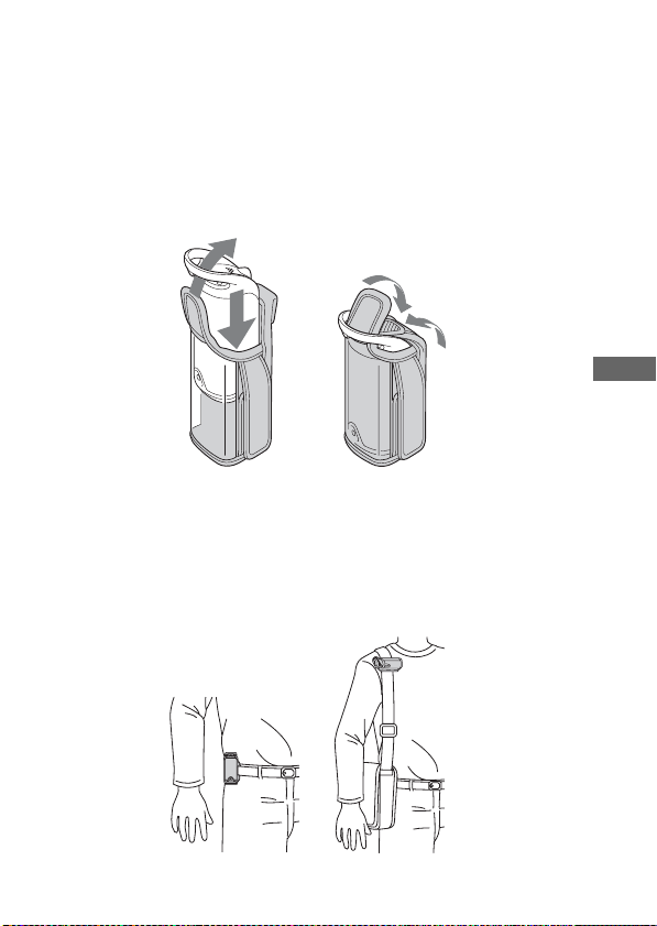
Inserting the GPS unit into the carrying case..............21
Carrying the GPS unit with the carrying case .............21
Carrying the GPS unit using the armband ..................22
Attach the GPS unit to the handle of a bicycle or a
motorcycle using the holder ........................................ 24
Using the unit
Record the GPS log using the GPS unit ..................... 27
Using the software
Using the supplied software........................................31
Installing the supplied software ...................................33
Apply position information to the images using “GPS
Image Tracker”............................................................. 35
View images on the “Picture Motion Browser” screen
.................................................................................... 38
GB
Table of contents
GB
5
Page 6

Additional information
Trouble shooting.......................................................... 39
Specifications.............................................................. 41
GB
6
Page 7

Precautions
When using this unit, please keep the following in mind.
On a battery
A battery is not supplied
An LR6 (size AA) alkaline battery or an HR6 (size AA) Nickel-Metal
Hydride battery is necessary for recording log data in this unit. Purchase a
battery before using the unit.
Notes on a Nickel-Metal Hydride battery
• Charge the Nickel-Metal Hydride battery before using the unit for the
first time. Refer to instructions supplied with the battery on charging.
• The battery can be charged even if it is not completely discharged. Also,
even if the battery is not fully charged, you can use the partially charged
capacity of the battery as is.
• If you do not intend to use the battery for a long time, use up the existing
charge and remove it from the unit, then store it in a cool, dry place.
This is to maintain the battery’s functions.
On recorded data on the unit
If you remove the battery while using the unit, the log data may be
damaged. Be sure to replace the battery with a new one after you turn the
power off.
Compensation for damaged log data will not be made
If position information (GPS log files) is not recorded properly due to
malfunction of the recording memory or the system, compensation for
damaged log data or images with position information will not be made.
On use and storage
• Before you use the unit, make sure that the unit works properly by
checking its operation.
• Do not shake or strike this unit hard. In addition to malfunctions and an
inability to record the log, this may cause recorded data breakdown.
• This unit is neither dust-proof, nor splash-proof, nor water-proof.
GB
GB
7
Page 8

Do not use/store the unit in the following places.
• In an extremely hot, cold or humid place
In places such as in a car parked in the sun, the unit body may become
deformed and this may cause a malfunction.
• In places near a heater
The unit may become discolored or deformed, and this may cause a
malfunction.
• Near strong magnetic place
• In sandy or dusty places
Be careful not to let sand or dust get into the unit. This may cause the
unit to malfunction, and in some cases this malfunction cannot be
repaired.
Note on the bracket
• When attaching the GPS unit to a bicycle or a motorcycle, be sure the
GPS unit does not interfere with the operation of the bicycle or the
motorcycle.
• Be sure not to operate the GPS unit while riding a bicycle or a
motorcycle.
• When you check the LED indicator on the GPS unit while riding a
bicycle or a motorcycle, be sure to stop operating the bicycle or the
motorcycle before checking the GPS unit.
• Do not apply the bracket other than the handle.
Note on the armband
• If using the armband causes skin irritation, stop using the armband
immediately.
• Be careful not to fasten the armband too tightly while using it. This may
interfere with the circulation of the blood.
• Do not attach the armband to the parts other than the arm.
Note on the included items
• Keep the included items out of the reach of children.
On carrying the unit
• Do not sit on a chair etc., with the unit in the back pocket of your pants
or skirt, as this may cause malfunction or damage the unit.
GB
8
Page 9

On cleaning the unit
Cleaning the unit surface
Clean the unit surface with a soft cloth slightly moistened with water,
then wipe the surface with a dry cloth. Do not use the following as they
may damage the finish or the casing.
• Chemical products such as thinner, benzine, alcohol, disposable cloths,
insect repellent, sunscreen or insecticide, etc.
• Do not touch the unit with the above on your hand.
• Do not leave the unit in contact with rubber or vinyl for a long time.
Note on the location where you use the GPS unit
Do not use the GPS unit in an airplane.
The radio wave may affect the airplane and this may cause an accident
due to the malfunction of the airplane.
Note on applying position information to still images taken with
digital still cameras or digital video cameras other than Sony
products
If the still images are JPEG files compatible with Exif 2.1 or later, you
can apply position information to those images.
However, please note that the application of the position information to
still images cannot be guaranteed for cameras from all manufacturers.
We recommend that you save the images under different file names after
applying position information, or backup the images before processing.
Also please note that the functions which will be unavailable after
processing with the program depend on each manufacturer.
GB
GB
9
Page 10
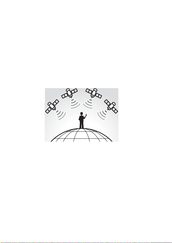
What is GPS?
The GPS is a navigational system that calculates position from accurate
US aviation satellites. This system allows you to track down your exact
location on the earth. The GPS satellites are located in six orbits, 20,000
km above us. The GPS consists of a total of 24 GPS satellites: Four of the
satellites are placed into each orbit, and at least three satellites are
required to pinpoint your location. A GPS receiver receives radio signals
from the satellites, and calculates the present location based on the orbital
information (almanac data) and travel time of the signals, etc.
Measuring a location is called “tracking”. A GPS receiver can track down
the location’s latitude and longitude by receiving signals from three
satellites.
10
GB
Page 11
Notes
• The positions of GPS satellites vary. Depending on the location and
time you use a GPS receiver, it may take longer for tracking or the
receiver may not track the location at all.
• “GPS” is the system tracking location by receiving radio signals from
GPS satellites. Avoid using the unit in the places where radio signals are
blocked or reflected, such as a shadowy place surrounded by buildings
or trees, etc. Use the unit in open sky environments.
G
P
S
• You may not record a GPS log at the locations or in the situations where
the radio signals from the GPS satellites do not reach to the unit as
follows.
– In tunnels, indoors or under shades of buildings.
– Between tall buildings or at narrow streets surrounded by buildings.
– At underground locations, surrounded by dense trees, under an
elevated bridge or at the locations where magnetic fields are generated
such as near high voltage cables.
– Near the devices that generate the radio signals of the same frequency
band as the unit: near the 1.5 GHz band mobile telephones, etc.
• The unit may not track when you are moving at the speed of about 500
km/hour (300 miles/hour) or faster.
GB
GB
11
Page 12

On tracking errors
Error caused by position of GPS satellites
The unit automatically tracks your present location when the unit receives
radio signals from three or more GPS satellites. The tracking error caused
by the GPS satellites is about to ±10 m. Depending on the environment of
the location, the tracking error can be greater. In this case, your actual
location may not match with the location on the map based on GPS
information.
Error during tracking process
This unit records position information every fifteen seconds.
When you have an image recorded at any moment other than the moments
when the unit records your position, the position information at that
moment can be provided using the supplied software “GPS Image
Tracker”. A rough position can be calculated by measuring the distances
between the locations before and after the image is recorded. In this case,
the actual position may not match completely with the location on the
map based on GPS information.
On error due to incorrect clock setting on a camera
When the clock setting on your camera is incorrect, you cannot apply the
correct position information to the images. The position information is
applied to the images based on the time information of the GPS log files
and the time stamps of the images. So if the time stamps are incorrect,
you cannot match the images with the GPS log files properly. Adjust the
clock setting of your camera properly. Refer to the operating instructions
of your camera on how to set the clock settings.
• For details on modification of the time stamp of the images, refer to the help files
of “GPS Image Tracker”.
12
GB
Page 13
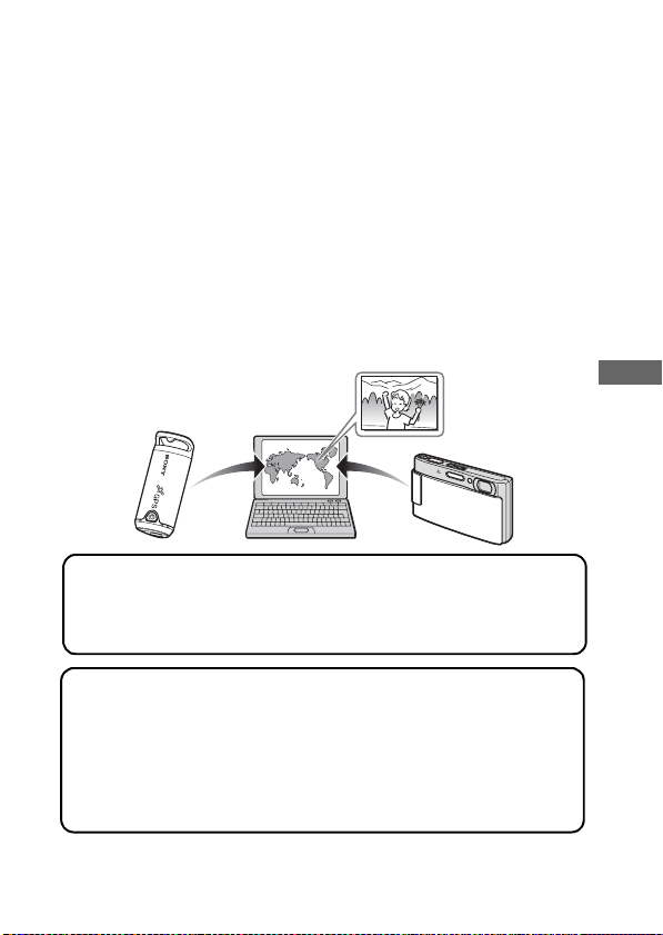
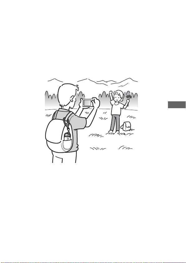
Features
This unit is a portable GPS unit to receive and record position
information.
Using this unit and the supplied software, you can:
• Check the locations of where you record still images or movies
(hereinafter collectively called “images”) on a trip, etc.
• Apply position information to the images you record, organize the
images by shooting date on the computer.
• You can display the recorded images and the tracks on the map and send
this map via e-mail.
Use the GPS unit outside
1
Using the supplied attachments, you can carry the GPS unit in
various situations (page 20).
Record the GPS log using the GPS unit
2
Turn on the unit, before you start recording images with your
digital camera, camcorder or digital single lens reflex camera
(hereinafter collectively called “camera”). The unit records
the GPS log (position and time) during your trip until the
power is turned off (page 27).
GB
GB
13
Page 14
Apply position information to the images using “GPS
3
Image Tracker”
1 Import the images taken with your camera to the computer
using the supplied software (Picture Motion Browser).
2 Launch the supplied software (GPS Image Tracker) and
import the GPS log recorded on the unit to your computer.
3 Load the images imported to your computer to “GPS
Image Tracker”.
4 Match the imported images with the GPS log files while
checking on the map, then apply the position information
of where you recorded the images (page 36).
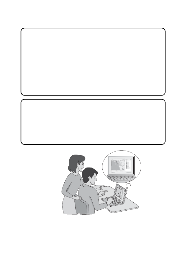
View images on the “Picture Motion Browser” screen
4
• You can show the tracks and images on the on-line map
using the “Map View” function of “Picture Motion Browser”
(page 38).
• You can send the original map data you created using the
e-mail.
14
GB
Page 15
Preparing
Checking included items
Make sure you have following things supplied with your GPS unit.
The number in parenthesis indicates the number of that item supplied.
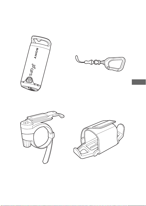
• GPS unit (GPS-CS1) (1) • Carabiner (1)
*1
GB
• Bracket (1)
*2
• Holder (1)
*2
Preparing
GB
15
Page 16
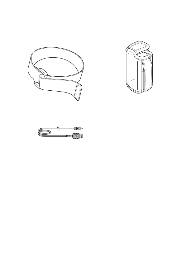
• Armband (1)
*2
• Carrying case (1)
• USB cable (1)
• CD-ROM
“GPS Unit Application Software” (1)
• Operating Instructions (this manual) (1)
• Set of other printed documentation
*1
An LR6 (size AA) alkaline battery or an HR6 (size AA) Nickel-Metal Hydride
battery is not supplied with this unit.
*2
The bracket, the holder, the armband and the carrying case are collectively called
the Attachment Kit.
GB
16
*2
Page 17
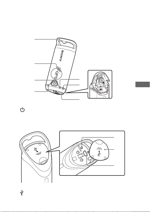
Identifying parts
1
2
3
4
1 Carabiner attachment loop 2 Antenna portion
3 (Power) button 4 GPS lamp
5 BATT (Battery) lamp 6 MEM FULL (Memory Full) lamp
7 Battery cover
8 CLEAR button 9 Jack cover
0 (USB) jack
5
6
7
8
9
0
Preparing
GB
GB
17
Page 18
Inserting a battery
The following batteries are acceptable.
• LR6 (size AA) alkaline battery*
• HR6 (size AA) Nickel-Metal Hydride battery (recommended for use at
low temperatures)
* When an LR6 (size AA) alkaline battery is used, the battery life is shorter at a low
temperature.
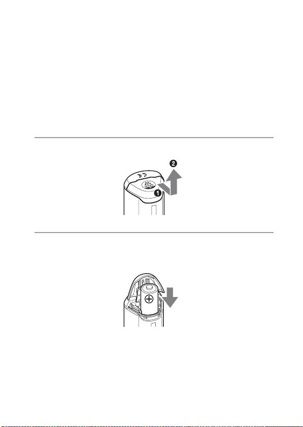
1 Slide the battery cover.
2 Insert a battery into the unit with the + side of the battery
facing up.
18
GB
Page 19
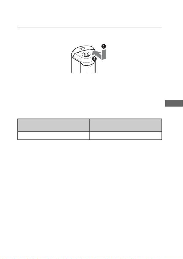
3 Close the battery cover.
To remove the battery
Turn the power off and hold the unit with the battery cover up, then
remove the battery.
Be sure not to drop the battery.
Battery duration (When used at 25 °C (77 °F))
LR6 (size AA) Sony alkaline battery
(not supplied)
about 10 hours about 14 hours
When you use the unit at low temperatures, we recommend you use a
•
Nickel-Metal Hydride battery.
• The battery duration may differ from the above depending on the
situation or the environmental condition.
Cautions
If you mishandle the battery, there is a danger of leakage or explosion. Be
sure to observe the following.
– Insert a battery with the correct polarity +/–.
– Do not charge a dry battery.
– Remove the battery when you do not use the unit for a long time.
Otherwise, it may result in leakage of the battery.
HR6 (size AA) Sony Nickel-Metal
Hydride battery (not supplied)
GB
Preparing
GB
19
Page 20
Use the GPS unit outside
Cautions on carrying the unit
• When you carry the unit, direct and hold the antenna-side upward or
outward.
• You can use the unit being covered with cloth, etc.
• The unit cannot receive radio signals when it is in a metallic bag such as
an attache case, or when it is covered with a metallic object.
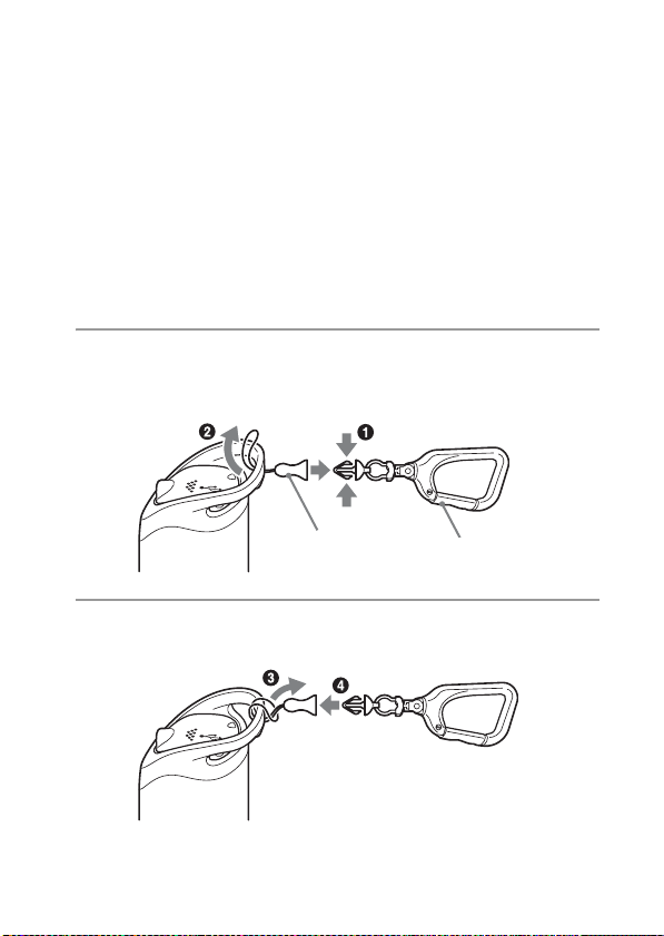
Carrying the GPS unit using the carabiner
You can attach the GPS unit to the bag etc., using the carabiner.
1 Detach the attachment string from the main body of the
carabiner as illustrated below (1) and draw the string
through the carabiner attachment loop of the unit (2).
Attachment
string
Main body of the
carabiner
2 Thread the carabiner string through the carabiner loop (3),
then attach it in the main body (4).
Caution
• Do not use the supplied carabiner for any other purpose.
GB
20
Page 21
Inserting the GPS unit into the carrying case
When you put in the GPS unit in the carrying case as illustrated below,
you can carry the GPS unit in various ways.
Carrying the GPS unit with the carrying case
You can attach the GPS unit to the belt of the trousers or the bag with the
GPS unit held in the carrying case.
GB
Use the GPS unit outside
GB
21
Page 22
Carrying the GPS unit using the armband
Using the supplied armband, you can attach the GPS unit to your arm.
1 Insert the GPS unit into the carrying case.
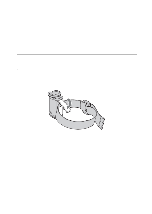
2 Attach the armband to the carrying case as illustrated
below.
22
GB
Page 23
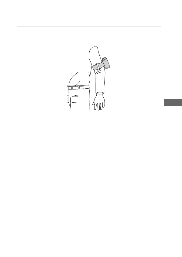
3 Attach the armband to your arm, then fasten the armband
appropriately.
Caution
– Do not apply the armband other than the GPS unit.
– If using the armband causes skin irritation, stop using the armband
immediately.
– Be careful not to fasten the armband too tightly while using it. This may
interfere with the circulation of the blood.
GB
Use the GPS unit outside
GB
23
Page 24
Attach the GPS unit to the handle of a bicycle or a motorcycle using the holder
Using the supplied holder and bracket, you can attach the GPS unit to the
handle of a bicycle or a motorcycle.
• The diameter of the handle supported by the bracket is 20 mm to 35 mm.
• Attach the bracket to the part where the GPS unit will not interfere with the
operation of the bicycle or motorcycle.
• The compatibility of the bracket cannot be guaranteed for all bicycles or
motorcycles.
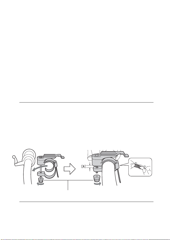
1 Attach the bracket to the handle of the bicycle etc.,
following the procedure below.
1 Remove the screw cap of the bracket, then wind the belt around the handle.
2 Adjust the belt and leave approx. 3 mm of space for the part [A] as illustrated
below.
3 Tighten the screw of the bracket firmly to fix it to the handle.
Pull both sides of
the belt to loosen
the belt.
3 mm
Screw cap
2 Insert the GPS unit into the carrying case.
GB
24
Page 25
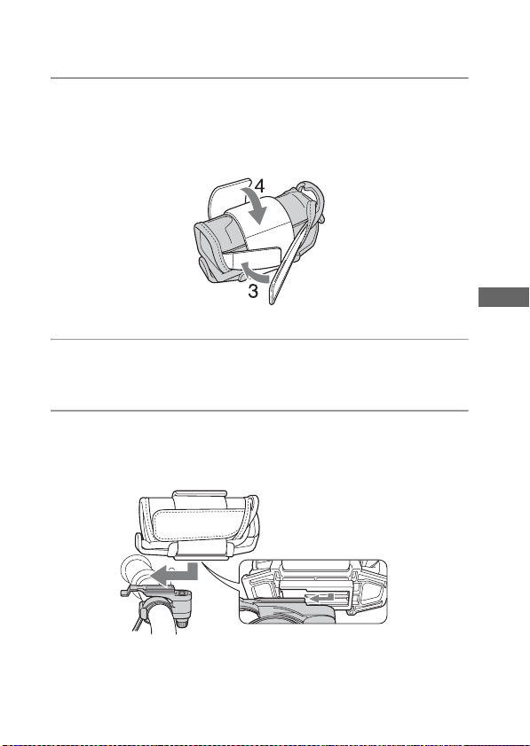
3 Place the GPS unit inserted in the carrying case on the
holder, then attach the GPS unit to the belt of the holder
using the hook-and-loop fastener on the side of the
carrying case.
4 Fix the GPS unit firmly using the hook-and-loop fastener of
the holder.
5 Align the groove on the bottom of the holder with the
groove of the bracket, then push the holder into the bracket
all the way until it clicks.
GB
Use the GPS unit outside
GB
25
Page 26
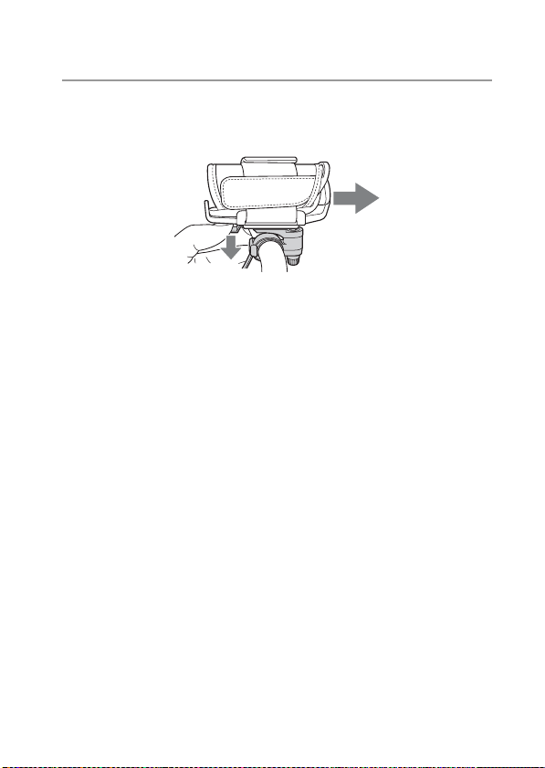
6 When removing the holder from the bracket, slide the
holder in the direction as illustrated below while pressing
down the knob of the bracket.
Caution
– Do not apply the bracket other than the handle.
– When attaching the GPS unit to a bicycle or a motorcycle, be sure the
GPS unit does not interfere with the operation of the bicycle or the
motorcycle.
– Be sure not to operate the GPS unit while riding a bicycle or a
motorcycle.
– When you check the LED indicator on the GPS unit while riding a
bicycle or a motorcycle, be sure to stop operating the bicycle or the
motorcycle before checking the GPS unit.
– If you attach the GPS unit to the holder without using the carrying case,
this may damage the GPS unit, or cause the GPS unit to fall. Be sure to
use the carrying case.
26
GB
Page 27
Using the unit
Record the GPS log using the GPS unit
This unit can record your position and time (GPS log files) in the internal
memory. When you turn on the power, tracking starts, and GPS log
recording starts. The unit tracks the location automatically and records
the position every fifteen seconds after tracking starts.
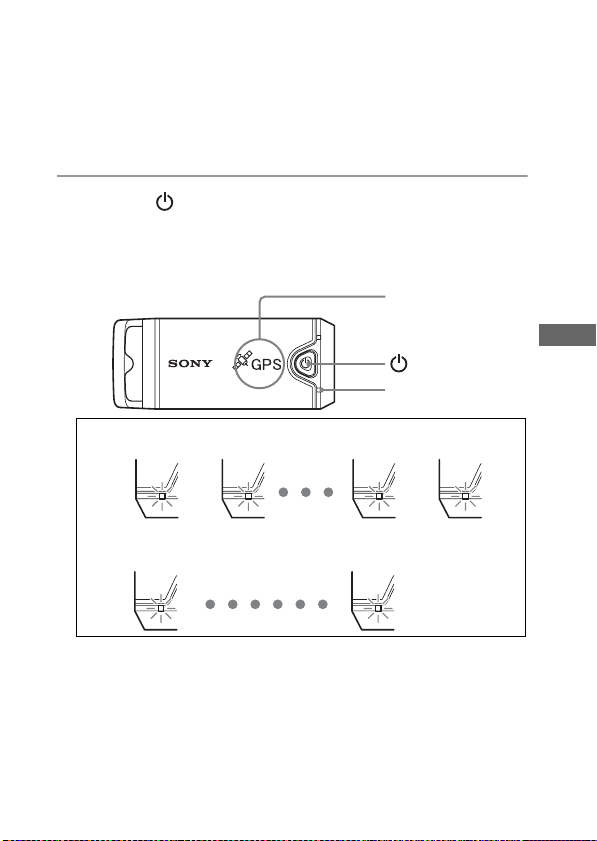
1 Press the (Power) button longer to turn on the unit.
Direct the antenna portion of the unit to the sky in open sky environments and
hold it for about a minute until the GPS lamp is in the tracking process.
The GPS lamp status differs as illustrated below depending on the operating
status of the unit.
Antenna portion
(Power) button
GPS lamp
GB
While searching*
flashes twice rapidly
1 second
While tracking*
flashes once slowly
2 seconds
* searching: the unit is searching for the GPS satellites and GPS log recording
tracking: the unit is tracking and recording the GPS log.
When it is difficult to make tracking and while the GPS lamp is in
•
hasn’t started.
flashes twice rapidly
flashes once slowly
searching, direct the antenna portion of the unit upward and wait for a
while. If the unit cannot track even after waiting for five minutes, you
may be in a location where the radio signals from GPS satellites cannot
be reached. Try again in open sky environments.
Using the unit
GB
27
Page 28
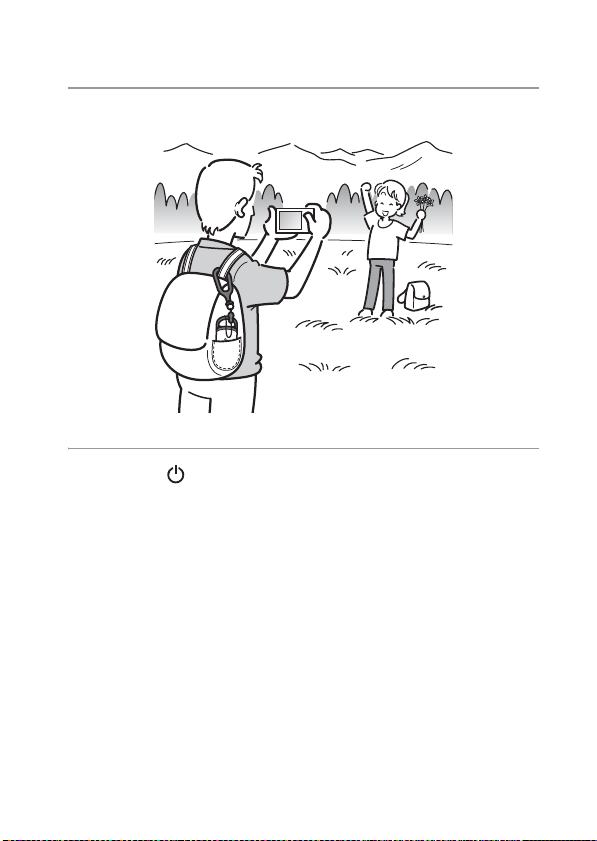
2 Record images with a camera.
G
P
S
3 Press the (Power) button longer to turn the unit off after
using.
• The GPS log recorded on the unit is stored as a log file during the time
the unit is turned on.
Tips
• Tracking may be difficult depending on the environmental condition. Check the
status of the GPS lamp at times.
• You can merge two GPS log files recorded separately due to on/off of the power
into one file using the supplied software. The position information will be
completed by this procedure. Be aware that once you merge the log files into one,
it cannot be separated again.
28
GB
Page 29

Checking remaining battery power
• You can check the remaining battery power on the status of the BATT
lamp by pressing (Power) button shorter with the power turned on.
Lights in green: 70 % or more power remains.*
Flashes green: 20 % to 70 % power remains.*
When the available remaining power becomes 20 % or lower, the BATT
lamp flashes red. When the remaining power becomes even lower, the
BATT lamp flashes more frequently and the unit is deactivated for
tracking. Replace the battery with a new one.
* This function may not operate properly when using a Nickel-Metal Hydride
battery.
BATT lamp
The unit consumes more battery power while searching than while
tracking.
Even if the unit calculates the remaining battery power and makes the
BATT lamp flash red while searching, when the unit switches from
searching to tracking, you may be able to use the unit longer.
Using the unit
GB
GB
29
Page 30

On the internal memory
The unit can record GPS log files up to about 360 hours.
• When the available internal memory becomes about 10 % or lower, the
MEM FULL lamp flashes red. When the internal memory becomes full,
the power is turned off automatically after the MEM FULL lamp lights
up for a minute.
• If you press the CLEAR button (page 17) longer with an object with a
tapered tip while the power is turned on, all the GPS log files in the
internal memory will be erased and the power goes off automatically.
MEM FULL lamp
30
GB
Page 31

Using the software
Using the supplied software
You can view the GPS log files recorded in the unit on the computer and
check the locations of where you recorded images on the map using the
supplied software.
This section describes the English version of screen contents.
The supplied CD-ROM contains “GPS Unit Application Software”
(“GPS Image Tracker” and “Picture Motion Browser”).
“GPS Image Tracker”
You can import the GPS log recorded in the unit to your computer, view
and manage the GPS log files. You can apply position information to the
images you recorded with your camera.
“Picture Motion Browser”
• You can organize the images on the calendar by date recorded and view
the images.
• Using the “Map View” function, you can check the recorded location of
the images and the tracks of the GPS log imported to the “GPS Image
Tracker” on the map.
• You can send the original map created with the “Map View” function
via e-mail.
Recommended computer environment
The following environment is recommended for using the supplied
software.
OS (pre-installed): Microsoft Windows 2000 Professional SP4/
Windows XP* SP2/Windows Vista*
* 64-bit editions and Starter (Edition) are not supported.
CPU/Memory: Pentium III 500 MHz or faster/256 MB or more
(Pentium III 800 MHz or faster/512 MB or more is recommended)
Hard Disk: Disk space required for installation – approximately 400 MB
Display: 1024 × 768 dots or more
• To operate movies, you need a computer system environment that
supports “Picture Motion Browser” supplied with your Cyber-shot or
Handycam.
Using the software
GB
GB
31
Page 32

Notes on connecting the unit to a computer
• Operations are not guaranteed for all the recommended computer
environments mentioned above.
• If you connect two or more USB devices to a single computer at the
same time, some devices, including your camera, may not operate,
depending on the types of USB devices you are using.
• Operations are not guaranteed when using a USB hub.
• When your computer resumes from a suspend or sleep mode,
communication between the unit and your computer may not recover at
the same time.
32
GB
Page 33

Installing the supplied software
Check the following before installing the supplied software.
• When handling the movies recorded with a Handycam or a
Cyber-shot, you need to install “Picture Motion Browser”
supplied in their kit additionally.
• Be aware of the following when installing “Picture Motion Browser”
supplied with the Handycam or the Cyber-shot (hereinafter collectively
called “cameras”).
– When the version of “Picture Motion Browser” installed on your
computer is older than “3.0.xx.xxxxx”, install “Picture Motion
Browser” supplied with the cameras first, then install “Picture Motion
Browser” using the CD-ROM supplied with this kit.
– When the version of “Picture Motion Browser” installed on your
computer is equivalent to “3.0.xx.xxxxx” or later, install “Picture
Motion Browser” using the CD-ROM supplied with this kit, then install
“Picture Motion Browser” supplied with the cameras. By doing this,
extra functions will be added.
Install the supplied software in the following procedures.
• Log on to a computer as Administrator.
Installing “GPS Image Tracker” and “Picture Motion Browser”
1 Turn on your computer, and insert the supplied CD-ROM
into the CD-ROM drive.
The screen to select the Setup Language appears.
• For Windows Vista, the AutoPlay screen appears. Select “Run Setup.exe.” and
follow the instruction that appears on the screen to proceed with the
installation.
• If the installation does not start, click [Start] t [My Computer] (for Windows
2000, double-click [My Computer]), then double-click the
(SONYPICTUTIL) icon.
GB
Using the software
GB
33
Page 34

2 Select the desired language, then click [Next].
The “License Agreement” screen appears.
3 Read the agreement carefully. If you accept the terms of
this agreement, click the radio button next to [I accept the
terms of the license agreement] and then click [Next].
The screen that shows the completion of the installation preparation appears.
4 Confirm the installation setting and click [Install].
5 Follow the instructions on the screen to complete the
installation.
• When the restarting confirmation message appears, restart the computer by
following the instructions on the screen.
• The installation screen of the software may appear depending on the system
environment of your computer. Follow the instruction to proceed the
installation.
6 Remove the CD-ROM after the installation is complete.
34
GB
Page 35

Apply position information to the images using “GPS Image Tracker”
Connect the unit to the computer, launch the supplied software, “GPS
Image Tracker”, and import GPS log files to the computer. You can then
apply the position information to the imported images.
• Before operating “GPS Image Tracker”, import the recorded images to
the computer using the supplied software “Picture Motion Browser”.
For details on the procedure to import images from the camera to the
computer, refer to the instruction manual supplied with the camera.
• Select [Help] t [About Picture Motion Browser] t [Supported
Formats] from the menu bar of “Picture Motion Browser” to check the
available types of the movie files.
• For details on “GPS Image Tracker”, refer to its help files ( ).
• When connecting the unit to the computer, it does not need a battery as
the power is supplied from the computer.
1 Launch “GPS Image Tracker”.
Double-click [ ] (GPS Image Tracker) on the desktop.
Or, from the Start menu: Click [Start] t [All Programs] (for Windows 2000,
[Programs]) t [Sony Picture Utility] t [GPS Image Tracker].
2 Connect the unit to the computer.
Pull out the jack cover as illustrated in the following and connect the unit with
the GPS log files to the computer using the supplied USB cable.
GB
Using the software
GB
35
Page 36

Note
The screen of the removable disk may appear, be sure not to update the data in
the GPS folder.
3 Import the GPS log files.
Click [OK] on the “Log File Import” window.
4 Delete the USB connection.
1 Double-click on the tasktray.
Double-click here
2 Click (USB Mass Storage Device) t [Stop].
3 Confirm the device on the confirmation window, then click [OK].
4 Click [Close].
The unit is disconnected from the computer.
5 Add images and apply position information to the images.
To add images, select the image files to which you want to apply position
information on “Picture Motion Browser”, then drag and drop them to the Media
File list on the main window of the “GPS Image Tracker”.
GB
36
Page 37

To apply the position information to all image files in the list, click [Add
Position Information to Files] on the main window, then click [Add].
• When using a computer that is connected to the Internet, you can match the
images and the GPS log files while checking on the map.
Main window
Media File list
• When using a computer that is not connected to the Internet, you can execute
the matching, but you cannot display the map.
Caution
• When you handle many images at once, the operation of your computer may
become slow depending on the system environment of your computer.
• When the application of the position information to the images is completed,
be sure to exit “GPS Image Tracker”.
[Add Position Information
to Files] button
Using the software
GB
GB
37
Page 38

View images on the “Picture Motion Browser” screen
The images and the tracks matched with “GPS Image Tracker” can be
viewed by using the “Map View” function of “Picture Motion Browser”.
1 Launch “Picture Motion Browser” on the computer.
Double-click [ ] (Picture Motion Browser) on the desktop.
Or, from the Start menu: Click [Start]
[Programs])
t [Sony Picture Utility] t [Picture Motion Browser].
2 Select the images that you want to display on the map.
You can only display the images with position information on the map. The
image files of the thumbnails with icons displayed on the upper right carry
the position information.
3 Click the icon.
The “Map View” window appears, and the selected images and the tracks
corresponding to the images are displayed.
* If you have not imported the log file of the same date as the images selected on
“GPS Image Tracker”, the tracks will not be displayed.
For details on using “Picture Motion Browser”, refer to the “PMB Guide”
().
* To use “Map View” function, your computer needs to be connected to the
Internet.
t [All Programs] (for Windows 2000,
Technical support
Additional information on this product and answers to frequently asked
questions can be found at the Sony Customer Support Website.
http://www.sony.net/
GB
38
Page 39

Additional information
Trouble shooting
If you run into any problem using the unit, use the following table to
troubleshoot the problem. If the problem persists, contact your Sony
dealer or local authorized Sony service facility.
A recorded log file is missing.
• You may have used the unit in the locations where the GPS unit cannot
track.
Avoid using the unit in the locations such as in tunnels, underground
locations or among obstructions such as tall buildings or trees.
The unit cannot receive radio signals from GPS satellites.
• You may be in a location where the radio signals from GPS satellites
cannot be reached.
Avoid using the unit in the locations such as in tunnels, underground
locations or among obstructions such as tall buildings or trees.
It takes much time to receive radio signals from GPS
satellites.
• It may take a long time to track the location depending on the positions
of GPS satellites.
For details, refer to “What is GPS?” on page 10.
You press the (Power) button, but the unit is not turned on.
• There may be a bad contact between the battery cover and the battery.
Open the battery cover and re-insert the battery.
• You may have used a battery with lower remaining power.
Replace the battery with a new one.
• The battery may not be inserted properly.
Insert a battery properly according to the procedures in “Inserting a
battery” (page 18).
• You cannot record the GPS log while the GPS unit is connected to the
computer. The BATT (battery) lamp will not light even if you press the
(Power) button.
GB
Additional information
GB
39
Page 40

Your computer does not recognize the unit.
• Your computer may not properly recognize the unit because you
connected the unit and your computer with the USB cable before you
started your computer.
Disconnect the USB cable and restart your computer, then connect the
USB cable again.
The images are not displayed at the correct position (Tracking
error is large).
• You may not apply the accurate position information to the images in
the following (page 12).
– The clock setting of the camera is incorrect. You can change the date
and time of your images using “Picture Motion Browser”. Set the date
and time correctly, then match the images and the GPS log files again.
For details on changing date and time, refer to the help files of
“Picture Motion Browser”.
– The setting of time adjustments (time zone or daylight saving time) is
incorrect. Using “GPS Image Tracker”, set the time adjustments of the
GPS log file correctly, then match the images and GPS log files again.
For details on the software, refer to the help files of “GPS Image
Tracker”.
– The GPS log file was not recorded when recording images.
– There is a certain limitation to the accuracy of the position
information applied by “GPS Image Tracker” due to the following
reasons.
• This unit records position information every fifteen seconds. If you
have an image recorded at any moment other than when the unit
records your position, a rough position is estimated by calculation.
• The GPS unit itself has tracking error. At locations surrounded by
tall buildings, etc. the tracking accuracy may deteriorate.
40
GB
Page 41

Specifications
Power
LR6 (size AA) alkaline battery or HR6 (size AA) Nickel-Metal
Hydride battery × 1 (Power is supplied from the USB bus power while
in the USB connection.)
Power consumption
Approx. 0.3 W (Operating on a battery)
Operating time on a battery (When used at 25 °C (77 °F))
Approx. 10 hours (When using an LR6 (size AA) Sony alkaline
battery),
Approx. 14 hours (When using an HR6 (size AA) Sony Nickel-Metal
Hydride battery)
Operating time may differ depending on the situation or the
environmental condition.
Receiving frequency
1575.42 MHz (L1 band, C/A code)
Receiving method
12 channel all-in-view tracking
Receiving sensitivity
−150 dBm or less (average, while tracking)
Interface
USB 2.0 full speed
Memory capacity
Approx. 31 MB
Logging interval
Approx. 15 seconds
Operating temperatures
Approx. 0 to 40 °C (32 to 104 °F)
Storage temperature
Approx. −20 to +60 °C (−4 to +140 °F)
Dimensions
Approx. 87 mm × 36 mm × 36 mm (3
(w/h/d, excluding the projecting parts)
1
/2 × 1 7/16 × 1 7/16 inches)
GB
Additional information
GB
41
Page 42

Mass
Approx. 55 g (2 oz) (excluding a battery)
Supported image format
JPEG (compatible with Exif 2.1 or later)
Movie file taken with your Sony Digital Still Camera or Sony Digital
Camcorder
(You need to install Picture Motion Browser supplied with your Sony
Digital Still Camera or Sony Digital Camcorder to your computer.)
Included items
• GPS Unit (GPS-CS1) (1)
• Carabiner (1)
• Bracket (1)
• Holder (1)
• Armband (1)
• Carrying case (1)
• USB cable (1)
• “GPS Unit Application Software” installer disc (1)
• Set of printed documentation
Design and specifications are subject to change without notice.
Trademarks
• Google is a registered trademark of Google Inc.
• Microsoft, Windows are either registered trademarks or trademarks of
Microsoft Corporation in the United States and/or other countries.
• Pentium is a trademark or registered trademark of Intel Corporation.
• In addition, system and product names used in this manual are, in
general, trademarks or registered trademarks of their respective
developers or manufacturers. However, the
™
or ® marks are not used in
all cases in this manual.
42
GB
Page 43

Page 44

Français
Avant d’utiliser l’unité, veuillez lire intégralement ce manuel et le
conserver pour référence future.
AVERTISSEMENT
Afin de réduire les risques d’incendie ou de décharge
électrique, n’exposez pas cet appareil à la pluie ou à
l’humidité.
Pour les utilisateurs au Canada
Cet appareil numérique de la classe B est conforme à la norme NMB-003
du Canada.
Note pour les clients européens
Par la présente, Sony Corporation déclare que cette unité GPS GPS-CS1
est conforme aux exigences essentielles et aux autres dispositions de la
directive 1999/5/CE.
Pour plus d’informations, visitez le site
http://www.compliance.sony.de/
Cet appareil a été testé et jugé conforme aux limites établies par la
directive R&TTE (équipement terminal de radio et télécommunications)
visant l’utilisation de câbles de connexion de moins de 3 mètres.
FR
2
Page 45

Traitement des appareils électriques et électroniques en
fin de vie (Applicable dans les pays de l’Union
Européenne et aux autres pays européens disposant de
systèmes de collecte sélective)
Ce symbole, apposé sur le produit ou sur son emballage, indique que ce
produit ne doit pas être traité avec les déchets ménagers. Il doit être remis
à un point de collecte approprié pour le recyclage des équipements
électriques et électroniques. En s’assurant que ce produit est bien mis au
rebut de manière appropriée, vous aiderez à prévenir les conséquences
négatives potentielles pour l’environnement et la santé humaine. Le
recyclage des matériaux aidera à préserver les ressources naturelles. Pour
toute information supplémentaire au sujet du recyclage de ce produit,
vous pouvez contacter votre municipalité, votre déchetterie ou le magasin
où vous avez acheté le produit.
FR
FR
3
Page 46

Table des matières
Précautions................................................................... 6
Qu’est-ce que le GPS ? ................................................ 9
Caractéristiques.......................................................... 13
Préparation
Vérification des éléments fournis ................................ 15
Identification des pièces.............................................. 17
Mise en place d’une batterie....................................... 18
Utilisation de l’unité GPS à l’extérieur
Précautions lors du transport de l’unité ...................... 20
Transport de l’unité GPS en utilisant le mousqueton ... 20
Placement de l’unité GPS dans l’étui de transport ..... 22
Transport de l’unité GPS avec l’étui de transport........ 22
Transport de l’unité GPS en utilisant le brassard........ 23
Installation de l’unité GPS sur la poignée d’une
bicyclette ou d’une moto en utilisant la monture......... 25
Utilisation de l’unité
Enregistrement du journal GPS au moyen de l’unité
GPS ............................................................................ 28
Utilisation du logiciel
Utilisation du logiciel fourni ......................................... 33
Installation du logiciel fourni........................................ 35
Application de coordonnées aux images au moyen de
« GPS Image Tracker »............................................... 37
Visualisation d’images sur l’écran « Picture Motion
Browser ».................................................................... 41
FR
4
Page 47

Informations complémentaires
Dépannage..................................................................43
Spécifications ..............................................................46
FR
FR
5
Page 48

Précautions
Lors de l’utilisation de cette unité, pensez aux points suivants.
Batterie
Une batterie n’est pas fournie
Une pile alcaline LR6 (format AA) ou une batterie Nickel-Métal Hydride
HR6 (format AA) est nécessaire pour enregistrer les données de journal
dans cette unité. Achetez une batterie avant d’utiliser l’unité.
Remarques sur les batteries Nickel-Métal Hydride
• Chargez la batterie Nickel-Métal Hydride avant d’utiliser l’unité pour la
première fois. Reportez-vous aux instructions fournies avec la batterie
pour sa charge.
• Vous pouvez charger la batterie même si elle n’est pas complètement
déchargée. Vous pouvez aussi utiliser la batterie même si elle n’est que
partiellement chargée.
• Si vous prévoyez de ne pas utiliser la batterie pendant une période
prolongée, déchargez-la en utilisant l’unité, puis retirez-la et rangez-la
dans un endroit frais et sec. Cela maintiendra toutes les fonctions de la
batterie.
A propos des données enregistrées dans l’unité
Si vous retirez la batterie pendant que vous utilisez l’unité, les données de
journal risquent d’être endommagées. Veillez à ne remplacer la batterie
par une neuve qu’après avoir coupé l’alimentation.
Aucun dédommagement pour données de journal détériorées
ne sera effectué
Si des informations de position (coordonnées) (fichiers de journal GPS)
ne sont pas enregistrées correctement du fait d’un dysfonctionnement de
la mémoire d’enregistrement ou du système, aucun dédommagement pour
données de journal ou images avec coordonnées détériorées ne sera
effectué.
FR
6
Page 49

Utilisation et rangement
• Avant d’utiliser l’unité, assurez-vous qu’elle fonctionne correctement.
• Ne secouez pas et ne heurtez pas violemment cette unité. Ceci pourrait
non seulement provoquer des dysfonctionnements et empêcher
l’enregistrement du journal, mais aussi provoquer une détérioration des
données enregistrées.
• Cette unité n’est résistante ni à la poussière, ni aux projections, ni à
l’eau.
N’utilisez/ne rangez pas l’unité dans les endroits suivants.
• Dans un endroit extrêmement chaud, froid ou humide
Dans un endroit comme une voiture garée au soleil ; le corps de l’unité
pourrait se déformer et cela pourrait provoquer un dysfonctionnement.
• Près d’un chauffage
L’unité pourrait se décolorer ou se déformer, et cela pourrait provoquer
un dysfonctionnement.
• Près d’un champ magnétique puissant
• Dans un endroit où il y a du sable ou de la poussière
Veillez à ce que du sable ou de la poussière ne pénètre pas dans l’unité.
Cela pourrait provoquer un dysfonctionnement de l’unité et, dans
certains cas, il serait impossible de la réparer.
Remarque sur le support
• Lorsque vous montez l’unité GPS sur une bicyclette ou une moto,
assurez-vous qu’elle n’interfère pas avec le fonctionnement de la
bicyclette ou de la moto.
• Ne manipulez jamais l’unité GPS pendant que vous roulez en bicyclette
ou en moto.
• Pour vérifier l’indicateur à LED de l’unité GPS en roulant en bicyclette
ou en moto, arrêtez-vous toujours avant de vérifier l’unité GPS.
• Ne montez pas le support sur une partie autre que la poignée.
Remarque sur le brassard
• Si l’utilisation du brassard provoque une irritation cutanée, arrêtez
immédiatement de l’utiliser.
• Veillez à ne pas serrer trop fort le brassard. Cela pourrait gêner la
circulation du sang.
• Ne mettez pas le brassard ailleurs que sur le bras.
FR
FR
7
Page 50

Remarque sur les éléments fournis
• Gardez les éléments fournis hors de portée des enfants.
Transport de l’unité
• Ne vous asseyez pas sur une chaise, etc. lorsque l’unité se trouve dans la
poche arrière de votre pantalon ou jupe, car cela pourrait provoquer un
dysfonctionnement ou endommager l’unité.
Nettoyage de l’unité
Nettoyage de l’extérieur de l’unité
Nettoyez l’extérieur de l’unité avec un tissu doux légèrement imbibé
d’eau, puis essuyez-le avec un chiffon sec. Pour ne pas risquer
d’endommager la finition ou le boîtier, évitez ce qui suit.
• Produits chimiques tels que diluant, benzine, alcool, lingettes
nettoyantes jetables, insectifuges, lotion solaire ou insecticides, etc.
• Manipulation de l’unité avec l’une des substances ci-dessus sur les
mains.
• Contact prolongé de l’unité avec du caoutchouc ou du vinyle.
Remarque sur l’endroit où vous utilisez l’unité GPS
N’utilisez pas l’unité GPS dans un avion.
Les ondes radio peuvent interférer avec le système de pilotage de l’avion,
ce qui pourrait provoquer un accident.
Remarque sur l’application de coordonnées à des images fixes
prises avec un appareil numérique ou caméscope numérique
autre que Sony
Si les images fixes sont des fichiers JPEG compatibles Exif 2.1 ou
ultérieur, vous pouvez appliquer des coordonnées à ces images.
Notez, toutefois, qu’il n’est pas possible de garantir l’application des
coordonnées à des images fixes pour les appareils de tous les fabricants.
Nous vous recommandons d’enregistrer les images sous des noms de
fichier différents après avoir appliqué des coordonnées ou de sauvegarder
les images avant le traitement.
Notez également que les fonctions qui ne seront pas disponibles après le
traitement avec le programme dépendent de chaque fabricant.
FR
8
Page 51

Qu’est-ce que le GPS ?
Le GPS est un système de navigation qui calcule la position actuelle à
partir de signaux précis de satellites de l’aviation américaine. Ce système
vous permet de déterminer votre localisation exacte sur la terre. Les
satellites GPS sont placés sur six orbites, 20 000 km au-dessus de nos
têtes. Le système GPS comprend un total de 24 satellites GPS : Quatre
des satellites sont placés sur chaque orbite et au moins trois satellites sont
nécessaires pour localiser avec précision votre position. Un récepteur
GPS capte des signaux radio des satellites et calcule la position actuelle
en se basant sur les informations orbitales (données d’almanach) et le
temps de propagation des signaux, etc.
La mesure d’une position est appelée « localisation ». Un récepteur GPS
peut localiser la latitude et la longitude d’une position en recevant des
signaux de trois satellites.
FR
FR
9
Page 52

Remarques
• Les positions des satellites GPS varient. Selon l’endroit et le moment où
vous utilisez un récepteur GPS, la localisation de la position peut
prendre plus longtemps ou le récepteur peut ne pas déterminer du tout la
position.
• « GPS » est le système localisant une position en captant des signaux
radio de satellites GPS. Evitez d’utiliser l’unité dans des endroits où les
signaux radio sont bloqués ou réfléchis, comme dans un lieu ombragé
entouré de bâtiments ou d’arbres, etc. Utilisez l’unité dans des lieux à
ciel ouvert.
G
P
S
10
FR
Page 53

• Vous ne pouvez pas enregistrer de journal GPS dans des endroits ou
situations où les signaux radio des satellites GPS n’atteignent pas
l’unité, comme ceux ci-dessous.
– Dans des tunnels, à l’intérieur ou à l’ombre de bâtiments.
– Entre de hauts immeubles ou dans des rues étroites entourées de
bâtiments.
– Dans des endroits souterrains, entourés d’arbres denses, sous un pont
surélevé ou dans des endroits où des champs magnétiques sont émis,
comme près de câbles à haute tension.
– Près de dispositifs qui émettent des signaux radio de la même bande
de fréquences que l’unité : près de téléphones portables à bande
1,5 GHz, etc.
• Il est possible que l’unité ne puisse pas localiser de position lorsque vous
vous déplacez à une vitesse d’environ 500 km/heure (300 mi/heure) ou
plus.
FR
FR
11
Page 54

Erreurs de localisation
Erreur provoquée par la position des satellites GPS
L’unité localise automatiquement votre position actuelle lorsqu’elle reçoit
des signaux radio de trois satellites GPS ou plus. L’erreur de localisation
provoquée par les satellites GPS est d’environ ±10 m. Selon les alentours
de votre emplacement actuel, l’erreur de localisation peut être plus
importante. Dans ce cas, votre position réelle peut ne pas correspondre à
l’endroit sur la carte basé sur les informations GPS.
Erreur pendant la localisation
Cette unité enregistre des coordonnées toutes les quinze secondes.
Lorsque vous avez une image enregistrée à un moment autre que ceux où
l’unité enregistre votre position, les coordonnées à ce moment-là peuvent
être obtenues au moyen du logiciel « GPS Image Tracker » fourni. Une
position approximative peut être calculée en mesurant les distances entre
les points avant et après que l’image est enregistrée. Dans ce cas, il est
possible que la position réelle ne corresponde pas exactement avec
l’endroit sur la carte basé sur les informations GPS.
Erreur due à un réglage incorrect de l’horloge de l’appareil
Lorsque le réglage de l’horloge de votre appareil est incorrect, vous ne
pouvez pas appliquer les coordonnées correctes aux images. Les
coordonnées sont appliquées aux images sur la base des informations
d’heure des fichiers de journal GPS et de l’horodatage des images. Si les
horodatages sont incorrects, vous ne pouvez donc pas faire correspondre
correctement les images avec les fichiers de journal GPS. Réglez
correctement l’horloge de votre appareil. Reportez-vous au mode
d’emploi de votre appareil pour la manière de régler l’horloge.
• Pour plus d’informations sur la modification de l’horodatage des images, reportezvous aux fichiers d’aide du logiciel « GPS Image Tracker ».
12
FR
Page 55

Caractéristiques
Ce dispositif est une unité GPS portable pour recevoir et enregistrer des
coordonnées.
En utilisant cette unité et le logiciel fourni, vous pouvez :
• Vérifier les endroits où vous avez enregistré des images fixes ou des
films (ci-après appelés collectivement « images ») lors d’un voyage, etc.
• Appliquer des coordonnées aux images que vous enregistrez, les
organiser par date de prise de vue sur un ordinateur.
• Vous pouvez afficher les images enregistrées et les localisations sur la
carte et envoyer cette carte par e-mail.
Utilisation de l’unité GPS à l’extérieur
1
Vous pouvez emporter l’unité GPS dans diverses situations en
utilisant les accessoires fournis (page 20).
Enregistrement du journal GPS au moyen de
2
l’unité GPS
Mettez l’unité sous tension avant de commencer à enregistrer
des images avec votre appareil numérique, caméscope ou
appareil reflex monoobjectif numérique (ci-après appelés
collectivement « appareil »). L’unité enregistre le journal GPS
(position et heure) pendant votre voyage jusqu’à ce que vous
la mettiez hors tension (page 28).
FR
FR
13
Page 56

Application de coordonnées aux images au moyen de
3
« GPS Image Tracker »
1 Importez les images prises avec votre appareil sur
l’ordinateur au moyen du logiciel (Picture Motion
Browser) fourni.
2 Lancez le logiciel fourni (GPS Image Tracker) et importez
le journal GPS enregistré dans l’unité sur votre ordinateur.
3 Chargez les images importées sur votre ordinateur dans
« GPS Image Tracker ».
4 Faites correspondre les images importées avec les fichiers
de journal GPS tout en vérifiant sur la carte, puis appliquez
les coordonnées des endroits où vous avez enregistré les
images (page 39).
Visualisation d’images sur l’écran « Picture Motion
4
Browser »
• Vous pouvez afficher les localisations et images sur la carte
en ligne au moyen de la fonction « Affichage Plan » de
« Picture Motion Browser » (page 41).
• Vous pouvez envoyer les données de carte originales par
e-mail.
14
FR
Page 57

Préparation
Vérification des éléments fournis
Assurez-vous que vous disposez des éléments suivants fournis avec votre
unité GPS.
Le chiffre entre parenthèses indique le nombre de cet élément fourni.
• Unité GPS (GPS-CS1) (1) • Mousqueton (1)
*1
FR
• Support (1)
*2
• Monture (1)
*2
Préparation
FR
15
Page 58

• Brassard (1)
*2
• Etui de transport (1)
• Câble USB (1)
• CD-ROM
« GPS Unit Application Software » (Logiciel d’application unité
GPS) (1)
• Mode d’emploi (ce manuel) (1)
• Jeu d’autres documents imprimés
*1
Une pile alcaline LR6 (format AA) ou une batterie Nickel-Métal Hydride HR6
(format AA) n’est pas fournie avec cette unité.
*2
Le support, la monture, le brassard et l’étui de transport sont appelés
collectivement le Kit fourni.
FR
16
*2
Page 59

Identification des pièces
1
2
3
4
1 Boucle de fixation du
mousqueton
2 Partie antenne
3 Touche (Alimentation)
4 Témoin GPS
8 Touche CLEAR (Effacer)
9 Couvercle de prise
5
6
7
5 Témoin BATT (Batterie)
6 Témoin MEM FULL
(Mémoire pleine)
7 Couvercle de batterie
8
9
0
0 Prise (USB)
Préparation
FR
FR
17
Page 60

Mise en place d’une batterie
Il est possible d’utiliser les batteries suivantes.
• Pile alcaline LR6 (format AA)*
• Batterie Nickel-Métal Hydride HR6 (format AA) (recommandée pour
une utilisation à basse température)
* La durée d’utilisation d’une pile alcaline LR6 (format AA) est plus courte à basse
température.
1 Faites glisser le couvercle de batterie.
2 Introduisez une batterie dans l’unité avec son côté + vers le
haut.
18
FR
Page 61

3 Fermez le couvercle de batterie.
Pour retirer la batterie
Coupez l’alimentation et tenez l’unité avec le couvercle de batterie vers le
haut, puis retirez la batterie.
Veillez à ne pas laisser tomber la batterie.
Autonomie de la batterie (Lors d’une utilisation à 25 °C (77 °F))
Pile alcaline LR6 (format AA) Sony
(non fournie)
environ 10 heures environ 14 heures
Nous vous recommandons d’utiliser une batterie Nickel-Métal Hydride
•
si vous utilisez l’unité à basse température.
• Il est possible que l’autonomie de la batterie soit différente des durées
ci-dessus selon la situation ou les conditions ambiantes.
Précautions
Il y a un risque de fuite ou d’explosion si vous manipulez incorrectement
la batterie. Veillez à respecter les points suivants.
– Introduisez une batterie en observant la polarité +/– correcte.
– Ne chargez pas une pile sèche.
– Retirez la batterie lorsque vous n’utilisez pas l’unité pendant longtemps.
Sinon, une fuite de la batterie pourrait se produire.
Batterie Nickel-Métal Hydride HR6
(format AA) Sony (non fournie)
FR
Préparation
FR
19
Page 62

Utilisation de l’unité GPS à l’extérieur
Précautions lors du transport de l’unité
• Lorsque vous transportez l’unité, dirigez et maintenez le côté antenne
vers le haut ou vers l’extérieur.
• Vous pouvez utiliser l’unité alors qu’elle est recouverte d’un linge, etc.
• L’unité ne peut pas recevoir de signaux radio lorsqu’elle se trouve dans
un sac métallique comme un attaché-case ou lorsqu’elle est recouverte
d’un objet métallique.
Transport de l’unité GPS en utilisant le mousqueton
Vous pouvez installer l’unité GPS sur un sac, etc. au moyen du
mousqueton.
1 Détachez le cordon de fixation du corps principal du
mousqueton comme illustré ci-dessous (1) et faites
passer le cordon dans la boucle de fixation de mousqueton
de l’unité (2).
20
Cordon de
fixation
FR
Corps principal du
mousqueton
Page 63

2 Enfilez le cordon de mousqueton par la boucle de
mousqueton (3), puis fixez-le au corps principal (4).
Précaution
• N’utilisez pas le mousqueton fourni à d’autres fins.
FR
Utilisation de l’unité GPS à l’extérieur
FR
21
Page 64

Placement de l’unité GPS dans l’étui de transport
Lorsque vous placez l’unité GPS dans l’étui de transport comme illustré
ci-dessous, vous pouvez l’emporter de plusieurs manières différentes.
Transport de l’unité GPS avec l’étui de transport
Vous pouvez installer l’unité GPS sur une ceinture de pantalon ou un sac
lorsqu’elle se trouve dans l’étui de transport.
22
FR
Page 65

Transport de l’unité GPS en utilisant le brassard
Vous pouvez installer l’unité GPS sur votre bras au moyen du brassard
fourni.
1 Introduisez l’unité GPS dans l’étui de transport.
2 Fixez l’étui de transport au brassard comme illustré ci-
dessous.
FR
Utilisation de l’unité GPS à l’extérieur
FR
23
Page 66

3 Passez le brassard à votre bras, puis serrez-le
convenablement.
Précaution
– N’utilisez le brassard que pour l’unité GPS.
– Si l’utilisation du brassard provoque une irritation cutanée, arrêtez
immédiatement de l’utiliser.
– Veillez à ne pas serrer trop fort le brassard. Cela pourrait gêner la
circulation du sang.
24
FR
Page 67

Installation de l’unité GPS sur la poignée d’une bicyclette ou d’une moto en utilisant la monture
Vous pouvez installer l’unité GPS sur la poignée d’une bicyclette ou
d’une moto à l’aide des support et monture fournis.
• Le diamètre de poignée pris en charge par le support est de 20 à 35 mm.
• Installez le support sur une partie où l’unité GPS n’interfère pas avec le
fonctionnement de la bicyclette ou moto.
• La compatibilité du support n’est pas garantie pour toutes les bicyclettes ou motos.
1 Installez le support sur la poignée de la bicyclette, etc. en
procédant comme suit.
1 Retirez le bouchon à vis du support, puis enroulez la courroie autour de la
poignée.
2 Ajustez la courroie et laissez un espace d’environ 3 mm pour la partie [A]
comme illustré ci-dessous.
3 Serrez fermement la vis du support pour le fixer à la poignée.
Tirez les deux côtés
de la courroie pour
la desserrer.
3 mm
Bouchon à vis
2 Introduisez l’unité GPS dans l’étui de transport.
Utilisation de l’unité GPS à l’extérieur
FR
FR
25
Page 68

3 Placez l’unité GPS introduite dans l’étui de transport sur la
monture, puis fixez l’unité GPS à la courroie de la monture
à l’aide de la bande velcro sur le côté de l’étui de transport.
4 Fixez fermement l’unité GPS au moyen de la bande velcro
de la monture.
5 Alignez la rainure sur le bas de la monture avec la rainure
du support, puis poussez à fond la monture dans le
support jusqu’au déclic.
26
FR
Page 69

6 Pour retirer la monture du support, faites glisser la
monture dans le sens illustré ci-dessous tout en appuyant
sur le bouton du support.
Précaution
– Ne montez pas le support sur une partie autre que la poignée.
– Lorsque vous montez l’unité GPS sur une bicyclette ou une moto,
assurez-vous qu’elle n’interfère pas avec le fonctionnement de la
bicyclette ou de la moto.
– Ne manipulez jamais l’unité GPS pendant que vous roulez en bicyclette
ou en moto.
– Pour vérifier l’indicateur à LED de l’unité GPS en roulant en bicyclette
ou en moto, arrêtez-vous toujours avant de vérifier l’unité GPS.
– Si vous installez l’unité GPS sur la monture sans utiliser l’étui de
transport, cela risque d’endommager l’unité GPS ou elle peut tomber.
Veillez à utiliser l’étui de transport.
FR
Utilisation de l’unité GPS à l’extérieur
FR
27
Page 70

Utilisation de l’unité
Enregistrement du journal GPS au moyen de l’unité GPS
Cette unité peut enregistrer votre position et l’heure (fichiers de journal
GPS) dans la mémoire interne. Lorsque vous mettez l’unité sous tension,
la localisation commence et l’enregistrement du journal GPS commence.
L’unité localise automatiquement l’emplacement et enregistre la position
toutes les quinze secondes après que la localisation commence.
1 Appuyez sur la touche (Alimentation) pendant un
certain temps pour mettre l’unité sous tension.
Dirigez la partie antenne de l’unité vers le ciel dans un endroit à ciel ouvert et
attendez pendant environ une minute jusqu’à ce que le témoin GPS soit en
procédé de localisation.
L’état du témoin GPS varie comme illustré ci-dessous selon l’état de
fonctionnement de l’unité.
Par tie ante nne
Touche
(Alimentation)
Témoin GPS
Pendant l’exploration*
clignote deux fois rapidement
1 seconde
Pendant la localisation*
clignote une fois lentement
2 secondes
* exploration : l’unité recherche les satellites GPS et l’enregistrement du
journal GPS n’a pas commencé.
localisation : l’unité localise et enregistre le journal GPS.
FR
clignote deux fois
rapidement
clignote une fois
lentement
28
Page 71

• Lorsque la localisation est difficile et pendant que le témoin GPS est en
mode d’exploration, dirigez la partie antenne de l’unité vers le haut et
attendez un moment. Si l’unité ne peut pas effectuer la localisation
même après une attente de cinq minutes, il est possible que vous vous
trouviez dans un endroit où les signaux radio des satellites GPS ne
peuvent pas être captés. Essayez de nouveau dans un endroit à ciel
ouvert.
2 Enregistrez des images avec un appareil.
G
P
S
FR
Utilisation de l’unité
FR
29
Page 72

3 Appuyez longuement sur la touche (Alimentation) pour
mettre l’unité hors tension après l’avoir utilisée.
• Le journal GPS enregistré dans l’unité est mémorisé comme fichier de
journal pendant le temps où l’unité est sous tension.
Conseils
• La localisation peut être difficile selon les conditions ambiantes. Vérifiez de temps
en temps l’état du témoin GPS.
• Vous pouvez fusionner deux fichiers de journal GPS enregistrés séparément du fait
de la mise sous/hors tension de l’unité en un seul fichier à l’aide du logiciel fourni.
Les coordonnées seront obtenues par cette procédure. Notez qu’une fois que vous
avez fusionné les fichiers de journal, il n’est pas possible de les séparer.
30
FR
Page 73

Vérification de la charge de batterie restante
• Vous pouvez vérifier la charge de batterie restante d’après l’état du
témoin BATT en appuyant brièvement sur la touche (Alimentation)
lorsque l’unité est sous tension.
S’allume en vert : 70 % ou plus de charge restante.*
Clignote en vert : 20 % à 70 % de charge restante.*
Lorsque la charge restante disponible atteint 20 % ou moins, le témoin
BATT clignote en rouge. Lorsque la charge restante devient encore plus
faible, le témoin BATT clignote plus rapidement et l’unité est désactivée
pour la localisation. Remplacez la batterie par une neuve.
* Il se peut que les indications de cette fonction ne soient pas correctes lors de
l’utilisation d’une batterie Nickel-Métal Hydride.
Témoin BATT
L’unité consomme plus pendant l’exploration que pendant la localisation.
Même si l’unité calcule la charge restante de la batterie et fait clignoter le
témoin BATT en rouge pendant l’exploration, vous pourrez peut-être
continuer à utiliser l’unité lorsqu’elle passe de l’exploration à la
localisation.
Utilisation de l’unité
FR
FR
31
Page 74

Mémoire interne
Cette unité peut enregistrer des fichiers de journal GPS pendant jusqu’à
environ 360 heures.
• Lorsque la mémoire interne disponible atteint 10 % ou moins, le témoin
MEM FULL clignote en rouge. Lorsque la mémoire interne est pleine,
l’alimentation se coupe automatiquement après que le témoin MEM
FULL s’allume pendant une minute.
• Si vous appuyez longuement sur la touche CLEAR (page 17) avec un
objet à extrémité conique alors que l’unité est sous tension, tous les
fichiers de journal GPS dans la mémoire interne sont effacés et l’unité
se met automatiquement hors tension.
Témoin MEM FULL
32
FR
Page 75

Utilisation du logiciel
Utilisation du logiciel fourni
Vous pouvez visualiser les fichiers de journal GPS enregistrés dans l’unité
sur un ordinateur et vérifier les endroits où vous avez enregistré les
images sur la carte à l’aide du logiciel fourni.
Cette section décrit la version anglaise des écrans.
Le CD-ROM fourni contient le « GPS Unit Application Software »
(Logiciel d’application unité GPS) (« GPS Image Tracker » et « Picture
Motion Browser »).
« GPS Image Tracker »
Vous pouvez importer le journal GPS enregistré dans l’unité sur votre
ordinateur, visualiser et gérer les fichiers de journal GPS. Vous pouvez
appliquer des coordonnées aux images que vous avez enregistrées avec
votre appareil.
« Picture Motion Browser »
• Vous pouvez organiser les images sur le calendrier par date
d’enregistrement pour les visualiser.
• En utilisant la fonction « Affichage Plan », vous pouvez vérifier, sur la
carte, l’emplacement enregistré des images et les localisations du
journal GPS importé vers le « GPS Image Tracker ».
• Vous pouvez envoyer la carte originale créée avec la fonction
« Affichage Plan » par e-mail.
Environnement matériel et logiciel recommandé
L’environnement suivant est recommandé pour utiliser le logiciel fourni.
Système d’exploitation (préinstallé) : Microsoft Windows 2000
Professionnel SP4/Windows XP* SP2/Windows Vista*
* Les éditions 64 bits et Starter (Edition) ne sont pas prises en charge.
Processeur/Mémoire : Pentium III 500 MHz ou plus rapide/256 Mo
ou plus (Pentium III 800 MHz ou plus rapide/512 Mo ou plus
recommandé)
Disque dur : Espace disque requis pour l’installation – 400 Mo environ
Ecran : 1024 × 768 points ou plus
• Pour des films, votre environnement matériel et logiciel doit prendre en
charge « Picture Motion Browser » fourni avec votre Cyber-shot ou
Handycam.
Utilisation du logiciel
FR
FR
33
Page 76

Remarques sur la connexion de l’unité à un ordinateur
• Les opérations ne sont pas garanties pour tous les environnements
matériels et logiciels mentionnés ci-dessus.
• Si vous connectez simultanément deux périphériques USB ou plus à un
même ordinateur, il se peut que certains d’entre eux, y compris votre
appareil, ne fonctionnent pas, selon le type de périphériques USB
utilisés.
• Les opérations ne sont pas garanties si vous utilisez un concentrateur
USB.
• Lorsque votre ordinateur quitte le mode de veille ou de mise en veille
prolongée, il se peut que la communication entre l’unité et l’ordinateur
ne soit pas rétablie simultanément.
34
FR
Page 77

Installation du logiciel fourni
Vérifiez les points suivants avant d’installer le logiciel fourni.
• Pour les films enregistrés avec un Handycam ou Cyber-shot,
vous devez aussi installer « Picture Motion Browser » fourni
dans leur kit.
• Notez les points suivants lors de l’installation de « Picture Motion
Browser » fourni avec le Handycam ou Cyber-shot (ci-après appelés
collectivement « appareils »).
– Si la version de « Picture Motion Browser » installée sur votre
ordinateur est antérieure à « 3.0.xx.xxxxx », installez tout d’abord
« Picture Motion Browser » fourni avec les appareils, puis installez
« Picture Motion Browser » au moyen du CD-ROM fourni avec ce kit.
– Si la version de « Picture Motion Browser » installée sur votre
ordinateur est « 3.0.xx.xxxxx » ou ultérieure, installez « Picture Motion
Browser » au moyen du CD-ROM fourni avec ce kit, puis installez
« Picture Motion Browser » fourni avec les appareils. En procédant
ainsi, des fonctions supplémentaires sont ajoutées.
Installez le logiciel fourni en procédant comme suit.
• Ouvrez une session sur l’ordinateur en tant qu’administrateur.
Installation de « GPS Image Tracker » et « Picture Motion
Browser »
1 Allumez l’ordinateur et introduisez le CD-ROM fourni dans
le lecteur de CD-ROM.
L’écran pour sélectionner la langue d’installation apparaît.
• Sous Windows Vista, l’écran AutoPlay apparaît. Sélectionnez « Run
Setup.exe. » et suivez les instructions qui apparaissent sur l’écran pour
procéder à l’installation.
• Si l’installation ne commence pas, cliquez sur [Start] (Démarrer) t [My
Computer] (Poste de travail) (sous Windows 2000, double-cliquez sur [My
Computer] (Poste de travail)), puis double-cliquez sur l’icône
(SONYPICTUTIL).
FR
Utilisation du logiciel
FR
35
Page 78

2 Sélectionnez la langue désirée, puis cliquez sur [Next]
(Suivant).
L’écran « License Agreement » (Contrat de licence) apparaît.
3 Lisez attentivement ce contrat. Si vous acceptez les termes
de ce contrat, cliquez sur le bouton à côté de [I accept the
terms of the license agreement] (J’accepte les termes du
contrat de licence), puis cliquez sur [Next] (Suivant).
L’écran qui indique l’achèvement de la préparation à l’installation apparaît.
4 Confirmez le réglage d’installation et cliquez sur [Install]
(Installer).
5 Suivez les instructions à l’écran pour terminer
l’installation.
• Lorsque le message de confirmation de redémarrage apparaît, redémarrez
l’ordinateur en suivant les instructions à l’écran.
• Il se peut que l’écran d’installation du logiciel apparaisse selon
l’environnement système de votre ordinateur. Suivez les instructions pour
procéder à l’installation.
6 Retirez le CD-ROM lorsque l’installation est terminée.
36
FR
Page 79

Application de coordonnées aux images au moyen de « GPS Image Tracker »
Connectez l’unité à l’ordinateur, lancez le logiciel « GPS Image Tracker »
fourni et importez les fichiers de journal sur l’ordinateur. Vous pouvez
alors appliquer les coordonnées aux images importées.
• Avant d’utiliser « GPS Image Tracker », importez les images
enregistrées sur l’ordinateur au moyen du logiciel « Picture Motion
Browser » fourni. Pour plus d’informations sur la procédure
d’importation d’images de l’appareil sur un ordinateur, reportez-vous au
mode d’emploi fourni avec l’appareil.
• Sélectionnez [Help] (Aide) t [About Picture Motion Browser] (À
propos de Picture Motion Browser) t [Supported Formats] (Formats
pris en charge) dans la barre de menu de « Picture Motion Browser »
pour vérifier les types de fichiers de film disponibles.
• Pour plus d’informations sur le logiciel « GPS Image Tracker »,
reportez-vous à ses fichiers d’aide ( ).
• Lors de la connexion de l’unité à l’ordinateur, une batterie est inutile car
l’alimentation est fournie par l’ordinateur.
1 Lancez le logiciel « GPS Image Tracker ».
Double-cliquez sur [ ] (GPS Image Tracker) sur le bureau.
Ou, depuis le menu Start (Démarrer) : Cliquez sur [Start] (Démarrer) t [All
Programs] (Tous les programmes) (sous Windows 2000, [Programs]
(Programmes)) t [Sony Picture Utility] t [GPS Image Tracker].
FR
Utilisation du logiciel
FR
37
Page 80

2 Connectez l’unité à l’ordinateur.
Ouvrez le couvercle de prise comme illustré ci-dessous et connectez l’unité
contenant les fichiers de journal GPS à l’ordinateur au moyen du câble USB
fourni.
Remarque
L’écran du disque amovible peut apparaître ; veillez à ne pas mettre à jour les
données dans le dossier GPS.
3 Importez les fichiers de journal GPS.
Cliquez sur [OK] dans la fenêtre « Log File Import » (Importation de fichiers
journaux).
38
FR
Page 81

4 Annulez la connexion USB.
1 Double-cliquez sur dans la barre des tâches.
Double-cliquez ici
2 Cliquez sur (USB Mass Storage Device = Périphérique de stockage de
masse USB) t [Stop] (Arrêter).
3 Confirmez le périphérique dans la fenêtre de confirmation, puis cliquez sur
[OK].
4 Cliquez sur [Close] (Fermer).
L’unité est déconnectée de l’ordinateur.
5 Ajoutez des images et appliquez des coordonnées aux
images.
Pour ajouter des images, sélectionnez les fichiers d’image auxquels vous désirez
appliquer des coordonnées dans « Picture Motion Browser », puis faites les
glisser jusqu’à la liste Fichiers multimédia dans la fenêtre principale de « GPS
Image Tracker ».
Pour appliquer les coordonnées à tous les fichiers d’image dans la liste, cliquez
sur [Add Position Information to Files] (Ajouter des coordonnées aux fichiers)
dans la fenêtre principale, puis cliquez sur [Add] (Ajouter).
FR
Utilisation du logiciel
FR
39
Page 82

• Lorsque vous utilisez un ordinateur qui est connecté à Internet, vous pouvez
faire correspondre les images et les fichiers de journal GPS tout en vérifiant
sur la carte.
Fenêtre principale
Liste Fichiers
multimédia
Touche [Add Position
Information to Files]
(Ajouter des coordonnées
aux fichiers)
• Lorsque vous utilisez un ordinateur qui n’est pas connecté à Internet, vous
pouvez exécuter la correspondance, mais vous ne pouvez pas afficher la carte.
Précaution
• Si vous traitez de nombreuses images en même temps, il se peut que votre
ordinateur ralentisse selon son environnement système.
• Lorsque l’application des coordonnées aux images est terminée, veillez à
fermer le logiciel « GPS Image Tracker ».
FR
40
Page 83

Visualisation d’images sur l’écran « Picture Motion Browser »
Vous pouvez visualiser les images et les localisations associées avec
« GPS Image Tracker » au moyen de la fonction « Affichage Plan » de
« Picture Motion Browser ».
1 Lancez « Picture Motion Browser » sur l’ordinateur.
Double-cliquez sur [ ] (Picture Motion Browser) sur le bureau.
Ou, depuis le menu Start (Démarrer) : Cliquez sur [Start] (Démarrer)
Programs] (Tous les programmes) (sous Windows 2000, [Programs]
(Programmes))
t [Sony Picture Utility] t [Picture Motion Browser].
2 Sélectionnez les images que vous souhaitez afficher sur la
carte.
Vous ne pouvez afficher que les images avec coordonnées sur la carte. Les
fichiers d’image des vignettes avec des icônes affichées en haut à droite
comportent des coordonnées.
3 Cliquez sur l’icône .
La fenêtre « Affichage Plan » apparaît et les images sélectionnées et les
localisations correspondant aux images sont affichées.
* Si vous n’avez pas importé le fichier de journal de la même date que les
images sélectionnées dans « GPS Image Tracker », les localisations ne seront
pas affichées.
Pour plus d’informations sur l’utilisation de « Picture Motion Browser »,
reportez vous au « Manuel de PMB » ( ).
* Votre ordinateur doit être connecté à Internet pour utiliser la fonction
« Affichage Plan ».
t [All
FR
Utilisation du logiciel
FR
41
Page 84

Support technique
Des informations complémentaires sur ce produit et des réponses à des
questions fréquemment posées sont disponibles sur le site Internet
d’assistance Client Sony.
http://www.sony.net/
42
FR
Page 85

Informations complémentaires
Dépannage
Si vous rencontrez un problème lors de l’utilisation de l’unité, reportezvous au tableau suivant pour remédier au problème. S’il persiste,
contactez votre distributeur Sony ou centre de service après-vente local
Sony.
Un fichier de journal enregistré manque.
• Il se peut que vous ayez utilisé l’unité dans des endroits où l’unité GPS
ne peut pas localiser.
Evitez d’utiliser l’unité dans des endroits comme dans des tunnels, des
lieux souterrains ou au milieu d’obstructions comme de hauts bâtiments
ou des arbres.
L’unité ne peut pas recevoir de signaux radio de satellites
GPS.
• Il se peut que vous vous trouviez dans un endroit où les signaux radio de
satellites GPS ne peuvent pas être captés.
Evitez d’utiliser l’unité dans des endroits comme dans des tunnels, des
lieux souterrains ou au milieu d’obstructions comme de hauts bâtiments
ou des arbres.
Il faut beaucoup de temps pour recevoir des signaux radio de
satellites GPS.
• La localisation de l’endroit peut prendre longtemps selon les positions
des satellites GPS.
Reportez-vous à « Qu’est-ce que le GPS ? » à la page 9 pour plus de
détails.
FR
Informations complémentaires
FR
43
Page 86

Vous appuyez sur la touche (Alimentation), mais l’unité ne
se met pas sous tension.
• Un mauvais contact entre le couvercle de batterie et la batterie est
possible.
Ouvrez le couvercle de batterie et remettez en place la batterie.
• Vous avez peut-être utilisé une batterie à faible charge restante.
Remplacez la batterie par une neuve.
• Il est possible que la batterie ne soit pas correctement en place.
Mettez une batterie correctement en place conformément aux
procédures de « Mise en place d’une batterie » (page 18).
• Vous ne pouvez pas enregistrer le journal GPS pendant que l’unité GPS
est connectée à l’ordinateur. Le témoin BATT (batterie) ne s’allume pas
même si vous appuyez sur la touche (Alimentation).
Votre ordinateur ne reconnaît pas l’unité.
• Il se peut que votre ordinateur ne reconnaisse pas correctement l’unité
parce que vous avez connecté l’unité et l’ordinateur avec le câble USB
avant de démarrer l’ordinateur.
Débranchez le câble USB, redémarrez l’ordinateur, puis reconnectez le
câble USB.
44
FR
Page 87

Les images ne s’affichent pas à la position correcte (l’erreur
de localisation est importante).
• Il est possible que vous ne puissiez pas appliquer les coordonnées
précises aux images dans les cas suivants (page 12).
– Le réglage de l’horloge de l’appareil est incorrect. Vous pouvez
changer la date et l’heure de vos images au moyen de « Picture
Motion Browser ». Réglez correctement la date et l’heure, puis faites
de nouveau correspondre les images et les fichiers de journal GPS.
Pour plus de détails sur le changement de date et d’heure, reportezvous aux fichiers d’aide de « Picture Motion Browser ».
– Le paramètre de réglage de l’heure (fuseau horaire ou heure d’été) est
incorrect. Utilisez « GPS Image Tracker » pour spécifier correctement
le réglage d’heure du fichier de journal GPS, puis faites de nouveau
correspondre les images et les fichiers de journal GPS. Pour plus de
détails sur le logiciel, reportez-vous aux fichiers d’aide de « GPS
Image Tracker ».
– Le fichier de journal GPS n’a pas été enregistré lors de
l’enregistrement des images.
– Il existe une certaine limite à la précision des coordonnées appliquées
par « GPS Image Tracker » du fait des raisons suivantes.
• Cette unité enregistre des coordonnées toutes les quinze secondes. Si
vous avez une image enregistrée à un moment autre que lorsque
l’unité enregistre votre position, une position approximative est
estimée par calcul.
• L’unité GPS elle-même comporte une erreur de localisation. Dans
des endroits entourés de grands bâtiments, etc., la précision de la
localisation peut se détériorer.
FR
Informations complémentaires
FR
45
Page 88

Spécifications
Alimentation
Pile alcaline LR6 (format AA) ou batterie Nickel-Métal Hydride HR6
(format AA) × 1 (l’alimentation est fournie par le bus USB pendant la
connexion USB.)
Consommation électrique
Environ 0,3 W (fonctionnement sur batterie)
Durée d’autonomie sur batterie (utilisation à 25 °C (77 °F))
Environ 10 heures (Lors de l’utilisation d’une pile alcaline LR6
(format AA) Sony),
Environ 14 heures (Lors de l’utilisation d’une batterie Nickel-Métal
Hydride HR6 (format AA) Sony)
La durée d’autonomie peut différer selon la situation ou les conditions
ambiantes.
Fréquence de réception
1575,42 MHz (bande L1, code C/A)
Méthode de réception
Localisation « tout en vue » 12 canaux
Sensibilité de réception
−150 dBm ou moins (moyenne, pendant la localisation)
Interface
USB 2.0 pleine vitesse
Capacité de mémoire
Environ 31 Mo
Intervalle de journalisation
Environ 15 secondes
Température de fonctionnement
Environ 0 à 40 °C (32 à 104 °F)
Température de stockage
Environ −20 à +60 °C (−4 à +140 °F)
Dimensions
Environ 87 mm × 36 mm × 36 mm (3
parties saillantes non comprises)
1
/2 × 1 7/16 × 1 7/16 po.) (l/h/p,
46
FR
Page 89

Poids
Environ 55 g (2 oz) (batterie non comprise)
Format d’image pris en charge
JPEG (compatible Exif 2.1 ou ultérieur)
Fichier de film pris avec votre appareil numérique Sony ou caméscope
numérique Sony
(Vous devez installer Picture Motion Browser fourni avec votre
appareil numérique Sony or caméscope numérique Sony sur votre
ordinateur.)
Articles inclus
• Unité GPS (GPS-CS1) (1)
• Mousqueton (1)
• Support (1)
• Monture (1)
•Brassard (1)
• Etui de transport (1)
•Câble USB (1)
• Disque d’installation « GPS Unit Application Software » (Logiciel
d’application unité GPS) (1)
• Jeu de documents imprimés
La conception et les spécifications peuvent être modifiées sans préavis.
Marques commerciales
• Google est une marque déposée de Google Inc.
• Microsoft, Windows sont des marques déposées ou marques
commerciales de Microsoft Corporation aux Etats-Unis et/ou dans
d’autres pays.
• Pentium est une marque commerciale ou marque déposée de Intel
Corporation.
• En outre, les noms de système et de produit utilisés dans ce manuel sont,
en général, des marques commerciales ou marques déposées de leurs
concepteurs ou fabricants respectifs. Les marques
™
ou ® ne sont
toutefois pas toujours indiquées dans ce manuel.
FR
Informations complémentaires
FR
47
Page 90

Page 91

 Loading...