

Page 1

MWELO 2015 Compliance Guide to Irrigation-Related Requirements
for New Construction Projects ≥500 Square Feet and
Rehabilitated Landscape Projects ≥2500 Square Feet
Easy-to-use guide and compliance tips for irrigation professionals.
Page 2

MWELO 2015 Compliance Guide to
Irrigation-related Requirements
How to Use This Guide
QUICK INFO:
Quick information or summary about a section or provision.
COMPLIANCE TIP:
General recommendations for compliance.
PRODUCT TIP:
Recommended Rain Bird products that comply with specic MWELO requirements.
Return to interactive table of contents.
This is a general reference guide for compliance with the 2015 California Model Water Ecient
Landscape Ordinance (MWELO) for these two types of projects:
• New construction projects with an aggregate landscape area equal to or greater than
500 square feet requiring a building or landscape permit, plan check or design review or
• Rehabilitated landscape projects with an aggregate landscape area equal to or greater
than 2,500 square feet requiring a building or landscape permit, plan check, or design review
Exceptions:
• This guide does not address cemeteries, which are also subject to MWELO
• Historical sites, restoration and reclamation projects that do not require permanent
irrigation, or botanical gardens and arboretums are exempt from the ordinance
• This guide does not address existing landscapes that do not require permits
This guide is based on information published by the State of California and the California Department
of Water Resources. It references only the landscape and irrigation-related provisions of the ordinance
and does not represent the entire ordinance. Any information in this guide is for general reference
only and is subject to change without notice. For the entire current version and status of the
ordinance, please visit
www.water.ca.gov
.
www.rainbird.com
2
Page 3
Table of Contents
Foreword
Part 1: Irrigation Requirements
492.7 Irrigation Design
492.10 Irrigation Scheduling
492.11 Landscape and Irrigation Maintenance Schedule
492.12 Irrigation Audit, Irrigation Survey, and Irrigation Water Use Analysis
492.13 Irrigation Eciency
492.5 Soil Management Report
492.6 Landscape Design
492.8 Grading Design Plan
Part 3: Recycled Water, Graywater and Stormwater Requirements
492.14 Recycled Water
492.15 Graywater Systems
492.16 Stormwater Management and Rainwater Retention
492.17 Public Education
492 Provisions for New Construction
492.18 Environmental Review
494 Eective Precipitation
492.1 Compliance with Documentation Package
492.2 Penalties
492.3 Elements of Documentation Package
Part 2: Soil Management, Landscape Design and
Grading Design Requirements
Part 4: Public Education Requirements
Part 5: Agency Requirements
Part 6: Documentation
492.4 Water Ecient Landscape Worksheet
492.9 Certicate of Completion
MWELO Appendix A ETo Tables
MWELO Appendix B Water Ecient Landscape Worksheet
MWELO Appendix C Sample Certicate of Completion
Part 7: Background and References
MWELO Backgrounder
490 Purpose
490.1 Applicability
491 Denitions
495 Reporting
Click on a section name below to go directly to the page
How to Use This Guide
QUICK INFO:
Quick information or summary
about a section or provision.
COMPLIANCE TIP:
General recommendations
for compliance.
PRODUCT TIP:
Recommended Rain Bird products
that comply with specic
MWELO requirements.
Return to interactive
table of contents.
www.rainbird.com
3
Page 4

P
Foreword
Statement on California’s Drought Conditions
California is facing an unprecedented water crisis, with 98 percent of the state experiencing some level of drought and
44 percent experiencing extreme drought. Governor Brown’s recent mandate for Californians to cut their water use by
25 percent has brought a long-standing issue to the forefront of the state’s consciousness—perhaps even to the world’s.
The conversation has nally turned from how we should use less water to how we must use less water.
The Association of California Water Agencies (ACWA) says more than 50 percent of all residential water use in the state of
California takes place outdoors. Furthermore, the ACWA estimates that California residents tend to over-water outdoor
plants and lawns by as much as 60 percent. These statistics indicate a tremendous opportunity to use this valuable
resource more eciently throughout California and the rest of the world.
Rain Bird’s Water Conservation Legacy
California’s current situation strikes a very personal chord for me and my family. Back in the early 1930s, my parents,
Clem and Mary LaFetra, established Rain Bird in the family barn in Glendora, California. Our very rst product, the original
impact sprinkler, was developed to more eciently irrigate nearby citrus orchards. Today, Rain Bird is a global leader in
ecient irrigation, but we have deep roots in California and remain headquartered just a few miles away from where it
all began.
Decades before the term “water restrictions” became a part of common vernacular, we recognized the need to protect
and eciently use our world’s most precious resource. Our guiding philosophy, The Intelligent Use of Water™, continues
to inuence all aspects of our business. Rain Bird has spent the past eight decades developing the industry’s most
comprehensive line of water-ecient irrigation solutions for everything from homes and schools to parks, sports elds,
golf courses and farms. With ecient irrigation products and practices, it is absolutely possible for the average California
resident to reduce outdoor water consumption by 25 percent or more without having to give up the plants, trees and
gardens that add so much to our lives.
Championing the Need for Change
We know that water-ecient irrigation products represent just one step down a long path toward positive change.
That’s why Rain Bird also focuses on helping people learn how to use water wisely and eciently. From our industryleading training group to our sales and engineering professionals, employees throughout our organization are
committed to the Intelligent Use of Water™. Every day, Rain Bird teaches irrigation professionals how to design, install
and operate more ecient systems and educate consumers worldwide about responsible outdoor water use.
Today, Rain Bird and our partners in the irrigation and water management industries are in a unique position to make a
dierence during this time of water crisis. By working together, we can make it easier for all Californians to signicantly
reduce their outdoor water use while still enjoying the many benets that green spaces have to oer. Rain Bird will
continue to develop products and initiatives that will help Californians make responsible, informed choices about the
ways we all use water. By taking advantage of intelligent watering products and practices today, we can usher in a new
era of water eciency and sustainable water use, not just in California, but around the world.
Anthony LaFetra, President
Rain Bird Corporation
www.rainbird.com
4
Page 5

P
Part 1: Irrigation Requirements
www.rainbird.com
5
Page 6
§ 492.7 Irrigation Design Plan
§ 492.7 Irrigation Design Plan
(a) This section applies to landscaped areas requiring permanent irrigation,
not areas that require temporary irrigation solely for the plant establishment
period. For the ecient use of water, an irrigation system shall meet all the
requirements listed in this section and the manufacturers’ recommendations.
The irrigation system and its related components shall be planned and
designed to allow for proper installation, management, and maintenance. An
irrigation design plan meeting the following design criteria shall be submitted
as part of the Landscape Documentation Package.
(1) System
(A) Landscape water meters, dened as either a dedicated water
service meter or private submeter, shall be installed for all
non-residential irrigated landscapes of 1,000 sq. ft. but not more
than 5,000 sq.ft. (the level at which Water Code 535 applies) and
residential irrigated landscapes of 5,000 sq. ft. or greater. A
landscape water meter may be either:
1. A customer service meter dedicated to landscape use
provided by the local water purveyor; or
2. A privately owned meter or submeter.
(B) Automatic irrigation controllers utilizing either evapotranspiration
or soil moisture sensor data utilizing non-volatile memory shall be
required for irrigation scheduling in all irrigation systems.
(C) If the water pressure is below or exceeds the recommended
pressure of the specied irrigation devices, the installation of a
pressure regulating device is required to ensure that the dynamic
pressure at each emission device is within the manufacturer’s
recommended pressure range for optimal performance.
PRODUCT TIP:
(A) LANDSCAPE WATER METERS
offers a complete family of central control,
commercial-grade controllers and flow sensors that,
when designed together, qualify as a water meter or
submeter. Rain Bird’s ICWM Series Water Meters
irrigation submeters are available through traditional
irrigation distribution channels.
ICWM Series Advanced Technology Water Meters
PRODUCT TIP:
(B) AUTOMATIC IRRIGATION CONTROLLERS
Rain Bird oers a full line of smart controllers, all with
non-volatile memory.
Rain Bird Controller Family
PRODUCT TIP:
(C.1) WATER PRESSURE
solutions to increase and decrease pressure to
operate at optimal water pressure. Use a pump to
increase pressure.
Rain Bird oers
Rain Bird
1. If the static pressure is above or below the required
dynamic pressure of the irrigation system, pressure-
regulating devices such as inline pressure regulators,
booster pumps, or other devices shall be installed to meet
the required dynamic pressure of the irrigation system.
2. Static water pressure, dynamic or operating pressure, and
ow reading of the water supply shall be measured at the
point of connection. These pressure and ow measurements
shall be conducted at the design stage. If the measurements
are not available at the design stage, the measurements
shall be conducted at installation.
www.rainbird.com
ACLP Series Pump Stations
Use pressure-regulating sprays and pressure-regulating
rotors and drip lters to decrease pressure.
PRS-SAM Rotors and Sprays
Pressure-Regulating Filter (RBY)
6
Page 7
§ 492.7 Irrigation Design Plan
(D) Sensors (rain, freeze, wind, etc.), either integral or auxiliary,
that suspend or alter irrigation operation during unfavorable
weather conditions shall be required on all irrigation systems, as
appropriate for local climatic conditions. Irrigation should be
avoided during windy or freezing weather or during rain.
(E) Manual shut-o valves (such as a gate valve, ball valve, or
buttery valve) shall be required, as close as possible to the
point of connection of the water supply, to minimize water loss in
case of an emergency (such as a main line break) or routine repair.
(F) Backow prevention devices shall be required to protect
the water supply from contamination by the irrigation system.
A project applicant shall refer to the applicable local agency code
(i.e., public health) for additional backow prevention requirements.
(G) Flow sensors that detect high ow conditions created by system
damage or malfunction are required for all on non-residential
landscapes and residential landscapes of 5000 sq. ft. or larger.
(H) Master shut-o valves are required on all projects except
landscapes that make use of technologies that allow for the
individual control of sprinklers that are individually pressurized in
a system equipped with low pressure shut down features.
(I) The irrigation system shall be designed to prevent runo, low
head drainage, overspray, or other similar conditions where
irrigation water ows onto non-targeted areas, such as adjacent
property, non-irrigated areas, hardscapes, roadways, or structures.
PRODUCT TIP:
(D) WEATHER SENSORS
wireless rain/freeze sensors. Anemometers are also
available with central control.
WR2 Wireless Rain Freeze Sensor
WS-PRO LT Weather Station | IQ Remote Water Management
PRODUCT TIP:
(G) FLOW SENSORS
family of ow sensors.
Rain Bird oers
Rain Bird oers a complete
(J) Relevant information from the soil management plan, such as soil
type and inltration rate, shall be utilized when designing
irrigation systems.
(K) The design of the irrigation system shall conform to the
hydrozones of the landscape design plan.
(L) The irrigation system must be designed and installed to meet,
at a minimum, the irrigation eciency criteria as described in
Section 492.4 regarding the Maximum Applied Water Allowance.
(M)
All irrigation emission devices must meet the requirements set in
the American National Standards Institute (ANSI) standard,
American Society of Agricultural and Biological Engineers’/
International Code Council’s (ASABE/ICC) 802-2014 Landscape
Irrigation Sprinkler and Emitter Standard, All sprinkler heads
installed in the landscape must document a distribution
uniformity low quarter of 0.65 or higher using the protocol
dened in ASABE/ICC 802-2014.
www.rainbird.com
Flow Sensor Family
PRODUCT TIP:
(M)
IRRIGATION EMISSION DEVICES
Bird® HE- VAN, U-Series, R-VAN and R-Series Nozzles all
meet the requirements of ASABE/ICC 802-2014 and
achieve DULQ of 70% or greater.
HE-VAN U-Series
R-VAN
Rain
7
Page 8
§ 492.7 Irrigation Design Plan
(N) It is highly recommended that the project applicant
or local agency inquire with the local water purveyor
about peak water operating demands (on the water
supply system) or water restrictions that may impact the
eectiveness of the irrigation system.
(O) In mulched planting areas, the use of low volume
irrigation is required to maximize water inltration into
the root zone.
(P) Sprinkler heads and other emission devices shall have
matched precipitation rates, unless otherwise directed by
the manufacturer’s recommendations.
(Q) Head to head coverage is recommended. However, sprinkler
spacing shall be designed to achieve the highest
possible distribution uniformity using the
manufacturer’s recommendations.
(R) Swing joints or other riser-protection components are
required on all risers subject to damage that are adjacent
to hardscapes or in high trac areas of turfgrass.
(S) Check valves or anti-drain valves are required on all
sprinkler heads where low point drainage could occur.
(T) Areas less than ten (10) feet in width in any direction shall
be irrigated with subsurface irrigation or other means
that produces no runo or overspray.
COMPLIANCE TIP:
(O) LOW-VOLUME IRRIGATION
mulched planting areas.
Xeri-Bug™ Emitters
PRODUCT TIP:
(P) MATCHED PRECIPITATION RATES (MPR)
Rain Bird oers a full line of matched precipitation rate
spray nozzles and MPR nozzles for 5000 Series Rotors.
HE-VAN U-Series
R-VAN
PRODUCT TIP:
(R) SWING JOINTS
assemblies for sprays and turf swing joints for rotors.
5000 MPR
Rain Bird has swing
is required in
www.rainbird.com
TSJ/TSJ PRS Series Swing Joints
PRODUCT TIP:
(S) CHECK VALVES
for sprays, rotors and drip to prevent drainage at low
points or when the sprinkler is o or damaged.
PRS-SAM Rotors & Sprays XFCV Dripline
PRODUCT TIP:
(T)
AREAS LESS THAN 10'
XFCV, and XFS-CV irrigation for areas less than 10'
XFS Subsurface
Dripline
Rain Bird oers check valves
Use Rain Bird XFS,
XFS-CV
Subsurface Dripline
8
Page 9
§ 492.7 Irrigation Design Plan
(U) Overhead irrigation shall not be permitted within 24 inches of
any non-permeable surface. Allowable irrigation within the setback
from non-permeable surfaces may include drip, drip line, or
other low ow non-spray technology. The setback area may be
planted or unplanted. The surfacing of the setback may be mulch,
gravel, or other porous material. These restrictions may be
modied if:
1. The landscape area is adjacent to permeable
surfacing and no runo occurs; or
2. The adjacent non-permeable surfaces are designed
and constructed to drain entirely to landscaping; or
3. The irrigation designer species an alternative design
or technology, as part of the Landscape
Documentation Package and clearly demonstrates
strict adherence to irrigation system design criteria
in Section 492.7 (a)(1)(I). Prevention of over-spray and
runo must be conrmed during the irrigation audit.
(V) Slopes greater than 25% shall not be irrigated with an irrigation
system with a application rate exceeding 0.75 inches per hour.
This restriction may be modied if the landscape designer
species an alternative design or technology, as part of the
Landscape Documentation Package, and clearly demonstrates no
runo or erosion will occur. Prevention of runo and erosion
must be conrmed during the irrigation audit.
PRODUCT TIP:
(U) 24" SETBACK
low volume irrigation solutions to irrigate within
the 24" setback.
Xeri-Bug™ Emitters
PRODUCT TIP:
(V)
SLOPES
and 5000 Series Rotors with MPR nozzles have a
precipitation rate of 0.6 in./hr.
R-VAN 5000 MPR
PRODUCT TIP:
(C) TREES
vital water, oxygen, and nutrients to bypass compacted
soil and directly reach tree and shrub root systems.
systems.
Rain Bird has a full line of
Rain Bird’s low precipitation rate R-VAN
The Root Watering System (RWS) enables
(2) Hydrozone
(A) Each valve shall irrigate a hydrozone with similar site, slope, sun
exposure, soil conditions, and plant materials with similar water use.
(B) Sprinkler heads and other emission devices shall be selected
based on what is appropriate for the plant type within that hydrozone.
(C) Where feasible, trees shall be placed on separate valves from
shrubs, groundcovers, and turf to facilitate the appropriate
irrigation of trees. The mature size and extent of the root
zone shall be considered when designing irrigation for the tree.
(D) Individual hydrozones that mix plants of moderate and low water
use, or moderate and high water use, may be allowed if:
1. Plant factor calculation is based on the proportions of
the respective plant water uses and their plant factor; or
2. The plant factor of the higher water using plant is
used for calculations.
www.rainbird.com
RWS Root Watering System
9
Page 10

§ 492.7 Irrigation Design Plan
(E) Individual hydrozones that mix high and low water use
plants shall not be permitted.
(F) On the landscape design plan and irrigation design plan,
hydrozone areas shall be designated by number, letter, or
other designation. On the irrigation design plan, designate
the areas irrigated by each valve, and assign a number to
each valve. Use this valve number in the Hydrozone
Information Table (see Appendix B Section A). This table
can also assist with the irrigation audit and programming
the controller.
(b) The irrigation design plan, at a minimum, shall contain:
(1) Location and size of separate water meters for landscape;
(2) Location, type and size of all components of the irrigation
system, including controllers, main and lateral lines, valves,
sprinkler heads, moisture sensing devices, rain switches, quick
couplers, pressure regulators, and backow prevention devices;
(3) Static water pressure at the point of connection to the
public water supply;
(4) Flow rate (gallons per minute), application rate
(inches per hour), and design operating pressure
(pressure per square inch) for each station;
QUICK INFO:
(b) IRRIGATION DESIGN PLAN
Note the requirements for the irrigation design plan.
QUICK INFO:
(4) FLOW RATE
same as precipitation rate.
Note that application rate is the
(5) Recycled water irrigation systems as specied in Section 492.14;
(6) The following statement: “I have complied with the criteria of
the ordinance and applied them accordingly for the ecient
use of water in the irrigation design plan”; and
(7) The signature of a licensed landscape architect, certied
irrigation designer, licensed landscape contractor, or any
other person authorized to design an irrigation system.
(See Sections 5500.1, 5615, 5641, 5641.1, 5641.2, 5641.3,
5641.4, 5641.5, 5641.6, 6701, 7027.5 of the Business and
Professions Code, Section 832.27 of Title 16 of the California
Code of Regulations, and Section 6721 of the Food and
Agricultural Code.)
Note: Authority cited: Section 65595, Government Code. Reference:
Section 65596, Government Code.
www.rainbird.com
10
Page 11

§ 492.10 Irrigation Scheduling
Certicate of Completion
§ 492.10 Irrigation Scheduling
(a) For the ecient use of water, all irrigation schedules shall be developed,
managed, and evaluated to utilize the minimum amount of water
required to maintain plant health. Irrigation schedules shall meet the
following criteria:
Irrigation scheduling shall be regulated by automatic irrigation controllers.
(1)
(2) Overhead irrigation shall be scheduled between 8:00 p.m. and 10:00
a.m. unless weather conditions prevent it. If allowable hours of
irrigation dier from the local water purveyor, the stricter of the two
shall apply. Operation of the irrigation system outside the normal
watering window is allowed for auditing and system maintenance.
(3) For implementation of the irrigation schedule, particular attention
must be paid to irrigation run times, emission device, ow rate,
and current reference evapotranspiration, so that applied water
meets the Estimated Total Water Use. Total annual applied water shall
be less than or equal to Maximum Applied Water Allowance (MAWA).
Actual irrigation schedules shall be regulated by automatic irrigation
controllers using current reference evapotranspiration data
(e.g., CIMIS) or soil moisture sensor data.
(4) Parameters used to set the automatic controller shall be developed
and submitted for each of the following:
QUICK INFO:
(492.10) IRRIGATION SCHEDULING
Note that the irrigation schedule parameters must
be included with the Certicate of Completion.
COMPLIANCE TIPS:
(2) HOURS ALLOWED
between 8 p.m. and 10 a.m. or to local water
windows, if stricter.
(3) SCHEDULE CONSIDERATIONS
• Reclaimed or other water sources high in salts or
sites with salt water intrusion may require leaching.
• Adjust valves for proper ow rates and
closing speeds.
• Rene irrigation schedules using real-time data from
weather stations and soil moisture sensors.
Schedule irrigation
(A) The plant establishment period;
(B) The established landscape; and
(C) Temporarily irrigated areas.
(5) Each irrigation schedule shall consider for each station all of the
following that apply:
(A) Irrigation interval (days between irrigation);
Irrigation run times (hours or minutes per irrigation event to avoid runo );
(B)
(C)
Number of cycle starts required for each irrigation event to avoid runo;
(D) Amount of applied water scheduled to be applied on a monthly basis;
(E) Application rate setting;
(F) Root depth setting;
(G) Plant type setting;
(H) Soil type;
(I) Slope factor setting;
(J) Shade factor setting; and
(K) Irrigation uniformity or eciency setting.
www.rainbird.com
11
Page 12

§ 492.11 Landscape and Irrigation
Certicate of Completion
Maintenance Schedule
§ 492.11 Landscape and Irrigation Maintenance Schedule
(a) Landscapes shall be maintained to ensure water use eciency.
A regular maintenance schedule shall be submitted with the
Certicate of Completion.
(b) A regular maintenance schedule shall include, but not be limited to,
routine inspection; auditing, adjustment and repair of the irrigation
system and its components; aerating and dethatching turf areas;
topdressing with compost, replenishing mulch; fertilizing; pruning;
weeding in all landscape areas, and removing obstructions to emission
devices. Operation of the irrigation system outside the normal watering
window is allowed for auditing and system maintenance.
(c) Repair of all irrigation equipment shall be done with the originally
installed components or their equivalents or with components with
greater eciency.
(d) A project applicant is encouraged to implement established landscape
industry sustainable Best Practices for all landscape maintenance activities.
QUICK INFO:
(492.11) LANDSCAPE AND IRRIGATION
MAINTENANCE SCHEDULE
maintenance schedule must be submitted as part of
the .
A landscape and
www.rainbird.com
12
Page 13

§ 492.12 Irrigation Audit, Irrigation Survey,
Certicate of Completion
and Irrigation Water Use Analysis
§ 492.12 Irrigation Audit, Irrigation Survey, and Irrigation
Water Use Analysis
(a) All landscape irrigation audits shall be conducted by a local agency
landscape irrigation auditor or a third party certied landscape irrigation
auditor. Landscape audits shall not be conducted by the person who
designed the landscape or installed the landscape.
(b) In large projects or projects with multiple landscape installations
(i.e. production home developments) an auditing rate of 1 in 7 lots or
approximately 15% will satisfy this requirement.
(c) For new construction and rehabilitated landscape projects installed after
December 1, 2015, as described in Section 490.1:
(1) The project applicant shall submit an irrigation audit report with the
Certicate of Completion to the local agency that may include, but
is not limited to: inspection, system tune-up, system test with
distribution uniformity, reporting overspray or run o that causes
overland ow, and preparation of an irrigation schedule, including
conguring irrigation controllers with application rate, soil types,
plant factors, slope, exposure and any other factors necessary for
accurate programming;
(2) The local agency shall administer programs that may include, but not be
limited to, irrigation water use analysis, irrigation audits, and irrigation
surveys for compliance with the Maximum Applied Water Allowance.
QUICK INFO:
(492.12) IRRIGATION AUDITS
• Submit an irrigation audit with the
Certicate of Completion.
• Landscape audits must be conducted by either a
local agency or a third-party certied landscape
irrigation auditor.
• Neither the designer nor the installer may conduct
the audit.
QUICK INFO:
(b) PRODUCTION HOMES
multiple landscape installations require a 15% audit
rate (1 in 7 lots).
Large projects with
www.rainbird.com
13
Page 14

§ 492.13 Irrigation Eciency
§ 492.13 Irrigation Eciency
(a) For the purpose of determining Estimated Total Water Use, average
irrigation eciency is assumed to be 0.75 for overhead spray devices and
0.81 for drip system devices.
QUICK INFO:
(492.13) IRRIGATION EFFICIENCY
You no longer have to calculate irrigation eciency.
Use:
• 0.75 for overhead spray devices
• 0.81 for drip system devices
www.rainbird.com
14
Page 15

P
Part 2: Soil Management, Landscape Design and
Grading Design Requirements
www.rainbird.com
15
Page 16

§ 492.5 Soil Management Report
§ 492.5 Soil Management Report
(a) In order to reduce runo and encourage healthy plant growth, a soil
management report shall be completed by the project applicant, or his/
her designee, as follows:
(1) Submit soil samples to a laboratory for analysis and recommendations.
(A) Soil sampling shall be conducted in accordance with laboratory
protocol, including protocols regarding adequate sampling
depth for the intended plants.
(B) The soil analysis shall include:
1. Soil texture;
2. Inltration rate determined by laboratory test or soil texture
inltration rate table;
3. pH;
4. Total soluble salts;
5. Sodium;
6. Percent organic matter; and
7. Recommendations
QUICK INFO:
(492.5) SOIL MANAGEMENT REPORT
Note the emphasis on proper soils and analysis.
(C) In projects with multiple landscape installations (i.e. production home
developments) a soil sampling rate of 1 in 7 lots or approximately
15% will satisfy this requirement. Large landscape projects shall
sample at a rate equivalent to 1 in 7 lots.
(2) The project applicant, or his/her designee, shall comply with one of
the following:
(A) If signicant mass grading is not planned, the soil analysis
report shall be submitted to the local agency as part of the
Landscape Documentation Package; or
(B) If signicant mass grading is planned, the soil analysis report shall be
submitted to the local agency as part of the Certicate of Completion.
(3) The soil analysis report shall be made available, in a timely manner, to
the professionals preparing the landscape design plans and irrigation
design plans to make any necessary adjustments to the design plans.
(4) The project applicant, or his/her designee, shall submit documentation
verifying implementation of soil analysis report recommendations to
the local agency with Certicate of Completion.
www.rainbird.com
16
Page 17

§ 492.6 Landscape Design Plan
§ 492.6 Landscape Design Plan
(a) For the ecient use of water, a landscape shall be carefully designed
and planned for the intended function of the project. A landscape
design plan meeting the following design criteria shall be submitted as
part of the Landscape Documentation Package.
(1) Plant Material
(A) Any plant may be selected for the landscape, providing the
Estimated Total Water Use in the landscape area does not exceed
the Maximum Applied Water Allowance. Methods to achieve
water eciency shall include one or more of the following:
1. Protection and preservation of native species and natural vegetation;
2. Selection of water-conserving plant, tree and turf species,
especially local native plants;
3. Selection of plants based on local climate suitability, disease
and pest resistance;
4. Selection of trees based on applicable local tree ordinances or
tree shading guidelines, and size at maturity as appropriate for
the planting area; and
5. Selection of plants from local and
regional landscape program plant lists.
QUICK INFO:
492.6. LANDSCAPE DESIGN PLAN
Note the emphasis on plant selection
and hydrozones.
6. Selection of plants from local Fuel Modication Plan Guidelines.
(B) Each hydrozone shall have plant materials with similar water use,
with the exception of hydrozones with plants of mixed water use,
as specied in Section 492.7(a)(2)(D).
(C) Plants shall be selected and planted appropriately based upon
their adaptability to the climatic, geologic, and topographical
conditions of the project site. Methods to achieve water
eciency shall include one or more of the following:
1. Use the Sunset Western Climate Zone System which takes
into account temperature, humidity, elevation, terrain,
latitude, and varying degrees of continental and marine
inuence on local climate;
2. Recognize the horticultural attributes of plants (i.e., mature
plant size, invasive surface roots) to minimize damage to
property or infrastructure [e.g., buildings, sidewalks, power
lines]; allow for adequate soil volume for healthy root growth;
and
3. Consider the solar orientation for plant placement to
maximize summer shade and winter solar gain.
www.rainbird.com
17
Page 18

§ 492.6 Landscape Design Plan
(D) Turf is not allowed on slopes greater than 25% where the toe
of the slope is adjacent to an impermeable hardscape and where
25% means 1 foot of vertical elevation change for every 4 feet of
horizontal length (rise divided by run x 100 = slope percent).
(E) High water use plants, characterized by a plant factor of 0.7 to 1.0,
are prohibited in street medians.
(F) A landscape design plan for projects in re-prone areas shall
address re safety and prevention. A defensible space or zone
around a building or structure is required per Public Resources
Code Section 4291(a) and (b). Avoid reprone plant materials
and highly ammable mulches. Refer to the local Fuel
Modication Plan guidelines.
(G) The use of invasive plant species, such as those listed by the
California Invasive Plant Council, is strongly discouraged.
(H) The architectural guidelines of a common interest development,
which include community apartment projects, condominiums,
planned developments, and stock cooperatives, shall not prohibit
or include conditions that have the eect of prohibiting the use
of low-water use plants as a group.
(2) Water Features
QUICK INFO:
(D) TURF
than 25% where the toe of the slope is adjacent to an
impermeable hardscape.
Slope percent = rise divided by run x 100.
QUICK INFO:
(2) WATER FEATURES
systems are required and recycled water use
is encouraged.
Turf is not allowed on slopes greater
Recirculating water
(A) Recirculating water systems shall be used for water features.
(B) Where available, recycled water shall be used as a source for
decorative water features.
(C) Surface area of a water feature shall be included in the high water
use hydrozone area of the water budget calculation.
(D) Pool and spa covers are highly recommended.
(3) Soil Preparation, Mulch and Amendments
(A) Prior to the planting of any materials, compacted soils shall be
transformed to a friable condition. On engineered slopes, only
amended planting holes need meet this requirement.
(B) Soil amendments shall be incorporated according to
recommendations of the soil report and what is appropriate for
the plants selected (see Section 492.5).
(C) For landscape installations, compost at a rate of a minimum of
four cubic yards per 1,000 square feet of permeable area shall be
incorporated to a depth of six inches into the soil. Soils with
greater than 6% organic matter in the top 6 inches of soil are
exempt from adding compost and tilling.
www.rainbird.com
18
Page 19

§ 492.6 Landscape Design Plan
Section 492.16
(D) A minimum three inch (3"
) layer of mulch shall be applied on all
exposed soil surfaces of planting areas except in turf areas,
creeping or rooting groundcovers, or direct seeding applications
where mulch is contraindicated. To provide habitat for beneficial
insects and other wildlife, up to 5% of the landscape area may be
left without mulch. Designated insect habitat must be included
in the landscape design plan as such.
(E) Stabilizing mulching products shall be used on slopes that meet
current engineering standards.
(F) The mulching portion of the seed/mulch slurry in hydro-seeded
applications shall meet the mulching requirement.
(G) Organic mulch materials made from recycled or post-consumer
shall take precedence over inorganic materials or virgin forest
products unless the recycled post-consumer organic products
are not locally available. Organic mulches are not required where
prohibited by local Fuel Modification Plan Guidelines or other
applicable local ordinances.
(b) The landscape design plan, at a minimum, shall:
(1) Delineate and label each hydrozone by number, letter, or other method;
(2) Identify each hydrozone as low, moderate, high water, or mixed water
use. Temporarily irrigated areas of the landscape shall be included in
the low water use hydrozone for the water budget calculation;
QUICK INFO:
(D) SOIL PREPARATION, MULCH AND
AMENDMENTS
on all exposed soil surfaces, except:
• Turf areas
• Creeping or rooting groundcovers
• Direct seeding applications where mulch is
contraindicated.
• In designated insect habitats, up to 5% of
landscaped area.
" of mulch is required
At least 3
COMPLIANCE TIP:
(D) 3" Mulch Layer
Mulch can obscure secondary utility boxes containing
ush valves for drip irrigation systems. Install a drip
irrigation system indicator to more easily locate the
ush point.
QUICK INFO:
(b) LANDSCAPE DESIGN PLAN
requirements of the landscape design plan.
QUICK INFO:
(10) LANDSCAPE DESIGN PLAN
to Section 492.16 for examples of stormwater best
management practices
Note the
Refer
(3) Identify recreational areas;
(4) Identify areas permanently and solely dedicated to edible plants;
(5) Identify areas irrigated with recycled water;
(6) Identify type of mulch and application depth;
(7) Identify soil amendments, type, and quantity;
(8) Identify type and surface area of water features;
(9) Identify hardscapes (pervious and non-pervious);
(10)
Identify location, installation details, and 24-hour retention or
inltration capacity of any applicable stormwater best management
practices that encourage on-site retention and inltration of
stormwater. Project applicants shall refer to the local agency or regional
Water Quality Control Board for information on any applicable
stormwater technical requirements. Stormwater best management
practices are encouraged in the landscape design plan and examples
are provided in Section 492.16.
www.rainbird.com
19
Page 20

§ 492.6 Landscape Design Plan
(11)
Identify any applicable rain harvesting or catchment technologies
as discussed in Section 492.16 and their 24-hour retention or
inltration capacity;
(12)
Identify any applicable graywater discharge piping, system
components and area(s) of distribution;
(13)
Contain the following statement: “I have complied with the criteria
of the ordinance and applied them for the ecient use of water
in the landscape design plan”; and
(14)
Bear the signature of a licensed landscape architect, licensed
landscape contractor, or any other person authorized to design a
landscape. (See Sections 5500.1, 5615, 5641, 5641.1, 5641.2, 5641.3,
5641.4, 5641.5, 5641.6, 6701, 7027.5 of the Business and Professions
Code, Section 832.27 of Title 16 of the California Code of Regulations,
and Section 6721 of the Food and Agriculture Code.)
www.rainbird.com
20
Page 21

§ 492.8 Grading Design Plan
§ 492.8 Grading Design Plan
(a) For the ecient use of water, grading of a project site shall be designed
to minimize soil erosion, runo and water waste. A grading plan
shall be submitted as part of the Landscape Documentation Package.
A comprehensive grading plan prepared by a civil engineer for other local
agency permits satises this requirement.
(1) The project applicant shall submit a landscape grading plan that
indicates nished congurations and elevations of the landscape
area including:
(A) Height of graded slopes;
(B) Drainage patterns;
(C) Pad elevations;
(D) Finish grade; and
(E) Stormwater retention improvements, if applicable.
(2) To prevent excessive erosion and runo, it is highly recommended
that the project applicants:
(A) Grade so that all irrigation and normal rainfall remains within
property lines and does not drain on to non-permeable hardscapes;
QUICK INFO:
(492.8) GRADING DESIGN PLAN
Design to minimize soil erosion, runo and
water waste.
(B) Avoid disruption of natural drainage pattern and undisturbed soil; and
(C) Avoid soil compaction in landscape areas.
(3) The grading design plan shall contain the following statement:
“I have complied with the criteria of the ordinance and applied them
accordingly for the ecient us of water in the grading design plan”
and shall bear the signature of a licensed professional as authorized
by law.
www.rainbird.com
21
Page 22

P
Part 3: Recycled Water, Graywater and
Stormwater Requirements
www.rainbird.com
22
Page 23

§ 492.14 Recycled Water
§ 492.14 Recycled Water
(a) The installation of recycled water irrigation systems shall allow for the
current and future use of recycled water.
(b) All recycled water irrigation systems shall be designed and operated in
accordance with all applicable local and State laws.
(c) Landscapes using recycled water are considered Special Landscape Areas.
The ET Adjustment Factor for new and existing (non-rehabilitated)
Special Landscape Areas shall not exceed 1.0.
PRODUCT TIP:
(492.14) RECYCLED WATER
Landscapes using recycled water are considered
Special Landscape Areas (SLA). SLAs have an ET
Adjustment Factor (ETAF) of 1.0.
Rain Bird oers components designed specically
to withstand the harsh conditions found in
recycled water, like the RD1800™ Series Sprays and
PESB-R Series Valves.
RD1800™ Series Sprays | PESB-R Series Valves
www.rainbird.com
23
Page 24

§ 492.15 Graywater Systems
ETWU
Section 490.1 (d)
§ 492.15 Graywater Systems
(a) Graywater systems promote the ecient use of water and are
encouraged to assist in on-site landscape irrigation. All graywater systems
shall conform to the California Plumbing Code (Title 24, Part 5, Chapter 16)
and any applicable local ordinance standards. Refer to § 490.1 (d) for the
applicability of this ordinance to landscape areas less than 2,500 square
feet with the Estimated Total Water Use met entirely by graywater.
QUICK INFO:
(492.15) GRAYWATER
encouraged. Refer to Section 490.1 (d) for ordinance
applicability to landscape areas < 2,500 sq.ft. with
ETWU met entirely by graywater.
Graywater systems are
www.rainbird.com
24
Page 25

§ 492.16 Stormwater Management and
Rainwater Retention
§ 492.16 Stormwater Management and Rainwater Retention
(a) Stormwater management practices minimize runo and increase
inltration which recharges groundwater and improves water quality.
Implementing stormwater best management practices into the
landscape and grading design plans to minimize runo and to increase
on-site rainwater retention and inltration are encouraged.
(b) Project applicants shall refer to the local agency or Regional Water
Quality Control Board for information on any applicable stormwater
technical requirements.
(c) All planted landscape areas are required to have friable soil to maximize
water retention and inltration. Refer to § 492.6(a)(3).
(d) It is strongly recommended that landscape areas be designed for capture
and inltration capacity that is sucient to prevent runo from
impervious surfaces (i.e. roof and paved areas) from either: the one
inch, 24-hour rain event or (2) the 85th percentile, 24-hour rain event,
and/or additional capacity as required by any applicable local, regional,
state or federal regulation.
(e) It is recommended that storm water projects incorporate any of the
following elements to improve on-site storm water and dry weather
runo capture and use:
PRODUCT TIP:
(492.16) STORMWATER MANAGEMENT
Rain Bird oers a complete family of
drainage products.
Rain Bird® Drainage Products
• Grade impervious surfaces, such as driveways, during construction to
drain to vegetated areas.
• Minimize the area of impervious surfaces such as paved areas, roof
and concrete driveways.
• Incorporate pervious or porous surfaces (e.g., gravel, permeable
pavers or blocks, pervious or porous concrete) that minimize runo.
• Direct runo from paved surfaces and roof areas into planting beds
or landscaped areas to maximize site water capture and reuse.
• Incorporate rain gardens, cisterns, and other rain harvesting or
catchment systems.
• Incorporate inltration beds, swales, basins and drywells to capture
storm water and dry weather runo and increase percolation into the soil.
• Consider constructed wetlands and ponds that retain water, equalize
excess ow, and lter pollutants.
www.rainbird.com
25
Page 26

P
Part 4: Public Education Requirements
www.rainbird.com
26
Page 27

§ 492.17 Public Education
§ 492.17 Public Education
(a) Publications. Education is a critical component to promote the ecient
use of water in landscapes. The use of appropriate principles of design,
installation, management and maintenance that save water is
encouraged in the community.
(1) A local agency or water supplier/purveyor shall provide information
to owners of permitted renovations and new, single-family residential
homes regarding the design, installation, management, and
maintenance of water ecient landscapes based on a water budget.
(b) Model Homes. All model homes that are landscaped shall use signs
and written information to demonstrate the principles of water ecient
landscapes described in this ordinance.
(1) Signs shall be used to identify the model as an example of a water
ecient landscape featuring elements such as hydrozones, irrigation
equipment, and others that contribute to the overall water ecient
theme. Signage shall include information about the site water use as
designed per the local ordinance; specify who designed and installed
the water ecient landscape; and demonstrate low water use
approaches to landscaping such as using native plants, graywater
systems, and rainwater catchment systems.
(2) Information shall be provided about designing, installing, managing,
and maintaining water ecient landscapes.
QUICK INFO:
(492.17) PUBLIC EDUCATION
Rain Bird’s
25 Ways oers practical, eective tips and advice
drawn from the company’s 80-plus years of
experience in the irrigation industry. These
resources can be used anywhere and by anyone
who wants to improve their watering eciency.
Visit 25ways.rainbird.com.
COMPLIANCE TIP:
(b) MODEL HOMES SIGNAGE
You can nd customizable signage to
promote water eciency on your projects
on the 25 Ways web page.
Take a permanent break
from over-watering
www.rainbird.com
25 WA
Water-smart ideas for
water-smart homeowners
25 WA
This yard only uses what it needs
Water Saving Tips: Text 25WAYS to 555888
Example of 25 Ways Yard Signs
WATER SAVING TIPS
Text 25WAYS to 555888
Water Saving Tips: Text 25WAYS to 555888
25 WA
D40731
D40731
27
Page 28

P
Part 5: Agency Requirements
www.rainbird.com
28
Page 29

§ 492 Provisions for New Construction or
Rehabilitated Landscapes
§ 492 Provisions for New Construction or Rehabilitated Landscapes
(a) A local agency may designate by mutual agreement, another agency,
such as a water purveyor, to implement some or all of the requirements
contained in this ordinance. Local agencies may collaborate with water
purveyors to dene each entity’s specic responsibilities relating to
this ordinance.
www.rainbird.com
29
Page 30

§ 494 Eective Precipitation
§ 494 Eective Precipitation
(a) A local agency may consider Eective Precipitation (25% of annual
precipitation) in tracking water use and may use the following equation
to calculate Maximum Applied Water Allowance:
MAWA= (ETo - Eppt) (0.62) [(0.55 x LA) + (0.45 x SLA)] for residential areas.
MAWA= (ETo-EPPT) (0.62) [(0.45 x LA) + (0.55 x SLA)] for non-residential areas.
Note: Authority cited: Section 65595, Government Code. Reference:
Section 65596, Government Code.
QUICK INFO:
(494) EFFECTIVE PRECIPITATION
Refer to Appendix B (page 52).
www.rainbird.com
30
Page 31

§ 492.18 Environmental Review
§ 492.18 Environmental Review
(a) The local agency must comply with the California Environmental
Quality Act (CEQA), as appropriate.
www.rainbird.com
31
Page 32

P
Part 6: Documentation
www.rainbird.com
32
Page 33

§ 492.1 Compliance with Landscape
Documentation Package
§ 492.1 Compliance with Landscape Documentation Package
(a) Prior to construction, the local agency shall:
(1) Provide the project applicant with the ordinance and procedures for
permits, plan checks or design reviews;
(2) Review the Landscape Documentation Package submitted by the
project applicant;
(3) Approve or deny the Landscape Documentation Package;
(4) Issue a permit or approve the plan check or design review for the
project applicant; and
(5) Upon approval of the Landscape Documentation Package, submit a copy
of the Water Ecient Landscape Worksheet to the local water purveyor.
(b) Prior to construction, the project applicant shall:
(1) Submit a Landscape Documentation package to the local agency.
(c) Upon approval of the Landscape Documentation package by the
local agency, the project applicant shall:
(1) Receive a permit or approval for the plan check or design review and
record the date of the permit in the Certicate of Completion;
QUICK INFO:
492.1. COMPLIANCE WITH LANDSCAPE
DOCUMENTATION PACKAGE
construction, check with your local agency.
Prior to
(2) Submit a copy of the approved Landscape Documentation Package
along with the record drawings, and any other information to the
property owner or his/her designee; and
(3) Submit a copy of the Water Ecient Landscape Worksheet to the
local water purveyor.
www.rainbird.com
33
Page 34

§ 492.2 Penalties
§ 492.2 Penalties
(a) A local agency may establish and administer penalties to the project
applicant for non-compliance with the ordinance to the extent permitted
by law.
www.rainbird.com
34
Page 35

§ 492.3 Elements of the Landscape
Documentation Package
§ 492.3 Elements of the Landscape Documentation Package
(a) The Landscape Documentation Package shall include the following
six (6) elements:
(1) Project information;
(A) Date
(B) Project applicant
(C) Project address if available, parcel and/or lot number(s))
(D) Total landscape area (square feet)
(E) Project type (e.g., new rehabilitated, public, private, cemetery,
homeowner-installed)
(F) Water supply type (e.g., potable, recycled, well) and identify the
local retail water purveyor if the applicant is not served by a
private well
(G) Checklist of all documents in Landscape Documentation Package
(H) Project contacts to include contact information for the project
applicant and property owner
(I) Applicant signature and date with statement, “I agree to comply
with the requirements of the water ecient landscape ordinance
and submit a complete Landscape Documentation Package”.
QUICK INFO:
492.3. ELEMENTS OF THE LANDSCAPE
DOCUMENTATION PACKAGE
Must include:
• Project information
• Water ecient landscape worksheet
• Soil management report
• Landscape design plan
• Irrigation design plan
• Grading design plan
(2) Water Ecient Landscape Worksheet;
(A) Hydrozone information table
(B) Water budget calculations
1. Maximum Applied Water Allowance (MAWA)
2. Estimated Total Water Use (ETWU)
(3) Soil management report;
(4) Landscape design plan;
(5) Irrigation design plan; and
(6) Grading design plan.
www.rainbird.com
35
Page 36

§ 492.4 Water Ecient Landscape Worksheet
§ 492.4 Water Ecient Landscape Worksheet
(a) A project applicant shall complete the Water Ecient Landscape
Worksheet in Appendix B which contains information on the plant
factor, irrigation method, irrigation eciency, and area associated
with each hydrozone. Calculations are then made to show that the
evapotranspiration adjustment factor (ETAF) for the landscape project
does not exceed a factor of 0.55 for residential areas and 0.45 for
non-residential areas, exclusive of Special Landscape Areas. The ETAF
for a landscape project is based on the plant factors and irrigation
methods selected. The Maximum Applied Water Allowance is calculated
based on the maximum ETAF allowed (0.55 for residential areas and
0.45 for non-residential areas) and expressed as annual gallons required.
The Estimated Total Water Use (ETWU) is calculated based on the plants
used and irrigation method selected for the landscape design. ETWU
must be below the MAWA.
(1) In calculating the Maximum Applied Water Allowance and Estimated
Total Water Use, a project applicant shall use the ETo values from
the Reference Evapotranspiration Table in Appendix A. For
geographic areas not covered in Appendix A, use data from other
cities located nearby in the same reference evapotranspiration zone,
as found in the CIMIS Reference Evapotranspiration Zones Map,
Department of Water Resources, 1999.
QUICK INFO:
492.4. WATER EFFICIENT LANDSCAPE
WORKSHEET
the Water Ecient Landscape Worksheet. ETo values
can be found in the Reference Evapotranspiration
Table in Appendix A (page 38).
Refer to Appendix B (page 52) for
COMPLIANCE TIP:
(b)(1) PLANT FACTORS:
• 0.0 - 0.1 = Very Low Water Use Plants
• 0.1 - 0.3 = Low Water Use Plants
• 0.4 - 0.6 = Moderate Water Use Plants
• 0.7 - 1.0 = High Water Use Plants
(b) Water budget calculations shall adhere to the following requirements:
(1) The plant factor used shall be from WUCOLS or from horticultural
researchers with academic institutions or professional associations as
approved by the California Department of Water Resources (DWR).
The plant factor ranges from 0 to 0.1 for very low water using plants,
0.1 to 0.3 for low water use plants, from 0.4 to 0.6 for moderate water
use plants, and from 0.7 to 1.0 for high water use plants.
(2) All water features shall be included in the high water use hydrozone and
temporarily irrigated areas shall be included in the low water use hydrozone.
(3) All Special Landscape Areas shall be identied and their water use
calculated as shown in Appendix B.
(4) ETAF for new and existing (non-rehabilitated) Special Landscape
Areas shall not exceed 1.0.
www.rainbird.com
36
Page 37

§ 492.9 Certicate of Completion
§ 492.9 Certicate of Completion
(a) The Certicate of Completion (see Appendix C for a sample certicate)
shall include the following six (6) elements:
(1) Project information sheet that contains:
(A) Date;
(B) Project name;
(C) Project applicant name, telephone, and mailing address;
(D) Project address and location; and
(E) Property owner name, telephone, and mailing address;
(2) Certication by either the signer of the landscape design plan, the
signer of the irrigation design plan, or the licensed landscape
contractor that the landscape project has been installed per the
approved Landscape Documentation Package;
(A) Where there have been signicant changes made in the eld
during construction, these “as-built” or record drawings shall be
included with the certication;
(B) A diagram of the irrigation plan showing hydrozones shall be kept
with the irrigation controller for subsequent management purposes.
QUICK INFO:
(492.9) CERTIFICATE OF COMPLETION
Refer to Appendix C (page 53) for a sample of the
Certicate of Completion.
(3) Irrigation scheduling parameters used to set the controller
(see Section 492.10);
(4) Landscape and irrigation maintenance schedule (see Section 492.11);
(5) Irrigation audit report (see Section 492.12); and
(6) Soil analysis report, if not submitted with Landscape Documentation
Package, and documentation verifying implementation of soil report
recommendations (see Section 492.5).
(b) The project applicant shall:
(1) Submit the signed Certicate of Completion to the local agency for review;
(2) Ensure that copies of the approved Certicate of Completion are
submitted to the local water purveyor and property owner or his or
her designee.
(c) The local agency shall:
(1) Receive the signed Certicate of Completion from the project applicant;
(2) Approve or deny the Certicate of Completion. If the Certicate of
Completion is denied, the local agency shall provide information to the
project applicant regarding reapplication, appeal, or other assistance.
www.rainbird.com
37
Page 38
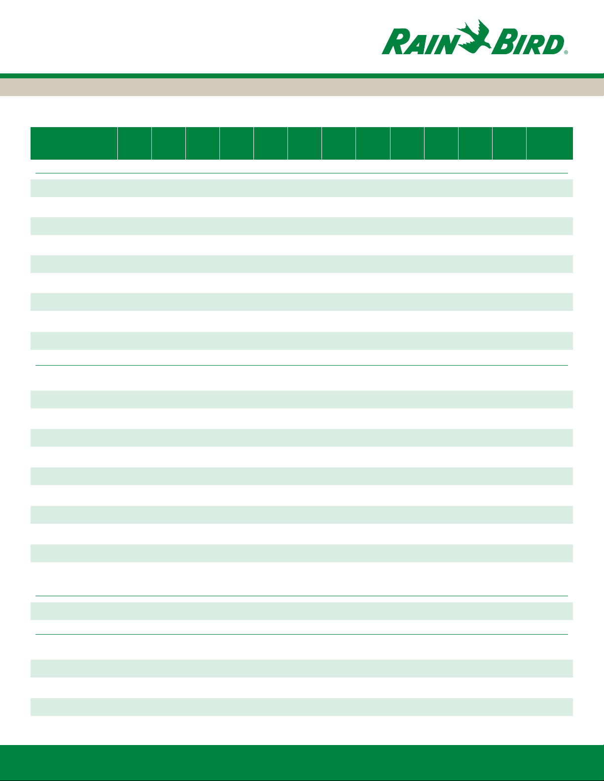
§ MWELO Appendix A ETo Tables
Appendix A - Reference Evapotranspiration (ETo) Table*
Annual
County and City Jan Feb Mar Apr May Jun Jul Aug Sep Oct Nov Dec ETo
ALAMEDA
Fremont 1.5 1.9 3.4 4.7 5.4 6.3 6.7 6.0 4.5 3.4 1.8 1.5 47.0
Livermore 1.2 1.5 2.9 4.4 5.9 6.6 7.4 6.4 5.3 3.2 1.5 0.9 47.2
Oakland 1.5 1.5 2.8 3.9 5.1 5.3 6.0 5.5 4.8 3.1 1.4 0.9 41.8
Oakland Foothills 1.1 1.4 2.7 3.7 5.1 6.4 5.8 4.9 3.6 2.6 1.4 1.0 39.6
Pleasanton 0.8 1.5 2.9 4.4 5.6 6.7 7.4 6.4 4.7 3.3 1.5 1.0 46.2
Union City 1.4 1.8 3.1 4.2 5.4 5.9 6.4 5.7 4.4 3.1 1.5 1.2 44.2
ALPINE
Markleeville 0.7 0.9 2.0 3.5 5.0 6.1 7.3 6.4 4.4 2.6 1.2 0.5 40.6
AMADOR
Jackson 1.2 1.5 2.8 4.4 6.0 7.2 7.9 7.2 5.3 3.2 1.4 0.9 48.9
Shanandoah Valley
BUTTE
Chico 1.2 1.8 2.9 4.7 6.1 7.4 8.5 7.3 5.4 3.7 1.7 1.0 51.7
Durham 1.1 1.8 3.2 5.0 6.5 7.4 7.8 6.9 5.3 3.6 1.7 1.0 51.1
Gridley 1.2 1.8 3.0 4.7 6.1 7.7 8.5 7.1 5.4 3.7 1.7 1.0 51.9
Oroville 1.2 1.7 2.8 4.7 6.1 7.6 8.5 7.3 5.3 3.7 1.7 1.0 51.5
CALAVERAS
San Andreas 1.2 1.5 2.8 4.4 6.0 7.3 7.9 7.0 5.3 3.2 1.4 0.7 48.8
COLUSA
Colusa 1.0 1.7 3.4 5.0 6.4 7.6 8.3 7.2 5.4 3.8 1.8 1.1 52.8
Williams 1.2 1.7 2.9 4.5 6.1 7.2 8.5 7.3 5.3 3.4 1.6 1.0 50.8
1.0 1.7 2.9 4.4 5.6 6.8 7.9 7.1 5.2 3.6 1.7 1.0 48.8
CONTRA COSTA
Brentwood 1.0 1.5 2.9 4.5 6.1 7.1 7.9 6.7 5.2 3.2 1.4 0.7 48.3
Concord 1.1 1.4 2.4 4.0 5.5 5.9 7.0 6.0 4.8 3.2 1.3 0.7 43.4
Courtland 0.9 1.5 2.9 4.4 6.1 6.9 7.9 6.7 5.3 3.2 1.4 0.7 48.0
Martinez 1.2 1.4 2.4 3.9 5.3 5.6 6.7 5.6 4.7 3.1 1.2 0.7 41.8
www.rainbird.com
38
Page 39

§ MWELO Appendix A ETo Tables
Annual
County and City Jan Feb Mar Apr May Jun Jul Aug Sep Oct Nov Dec ETo
CONTRA COSTA
Moraga 1.2 1.5 3.4 4.2 5.5 6.1 6.7 5.9 4.6 3.2 1.6 1.0 44.9
Pittsburg 1.0 1.5 2.8 4.1 5.6 6.4 7.4 6.4 5.0 3.2 1.3 0.7 45.4
Walnut Creek 0.8 1.5 2.9 4.4 5.6 6.7 7.4 6.4 4.7 3.3 1.5 1.0 46.2
DEL NORTE
Crescent City 0.5 0.9 2.0 3.0 3.7 3.5 4.3 3.7 3.0 2.0 0.9 0.5 27.7
EL DORADO
Camino 0.9 1.7 2.5 3.9 5.9 7.2 7.8 6.8 5.1 3.1 1.5 0.9 47.3
FRESNO
Clovis 1.0 1.5 3.2 4.8 6.4 7.7 8.5 7.3 5.3 3.4 1.4 0.7 51.4
Coalinga 1.2 1.7 3.1 4.6 6.2 7.2 8.5 7.3 5.3 3.4 1.6 0.7 50.9
Firebaugh 1.0 1.8 3.7 5.7 7.3 8.1 8.2 7.2 5.5 3.9 2.0 1.1 55.4
FivePoints 1.3 2.0 4.0 6.1 7.7 8.5 8.7 8.0 6.2 4.5 2.4 1.2 60.4
Fresno 0.9 1.7 3.3 4.8 6.7 7.8 8.4 7.1 5.2 3.2 1.4 0.6 51.1
Fresno State 0.9 1.6 3.2 5.2 7.0 8.0 8.7 7.6 5.4 3.6 1.7 0.9 53.7
Friant 1.2 1.5 3.1 4.7 6.4 7.7 8.5 7.3 5.3 3.4 1.4 0.7 51.3
Kerman 0.9 1.5 3.2 4.8 6.6 7.7 8.4 7.2 5.3 3.4 1.4 0.7 51.2
Kingsburg 1.0 1.5 3.4 4.8 6.6 7.7 8.4 7.2 5.3 3.4 1.4 0.7 51.6
Mendota 1.5 2.5 4.6 6.2 7.9 8.6 8.8 7.5 5.9 4.5 2.4 1.5 61.7
Reedley 1.1 1.5 3.2 4.7 6.4 7.7 8.5 7.3 5.3 3.4 1.4 0.7 51.3
Westlands 0.9 1.7 3.8 6.3 8.0 8.6 8.6 7.8 5.9 4.3 2.1 1.1 58.8
GLENN
Orland 1.1 1.8 3.4 5.0 6.4 7.5 7.9 6.7 5.3 3.9 1.8 1.4 52.1
Willows 1.2 1.7 2.9 4.7 6.1 7.2 8.5 7.3 5.3 3.6 1.7 1.0 51.3
HUMBOLDT
Eureka 0.5 1.1 2.0 3.0 3.7 3.7 3.7 3.7 3.0 2.0 0.9 0.5 27.5
Ferndale 0.5 1.1 2.0 3.0 3.7 3.7 3.7 3.7 3.0 2.0 0.9 0.5 27.5
Garberville 0.6 1.2 2.2 3.1 4.5 5.0 5.5 4.9 3.8 2.4 1.0 0.7 34.9
Hoopa 0.5 1.1 2.1 3.0 4.4 5.4 6.1 5.1 3.8 2.4 0.9 0.7 35.6
www.rainbird.com
39
Page 40
§ MWELO Appendix A ETo Tables
Annual
County and City Jan Feb Mar Apr May Jun Jul Aug Sep Oct Nov Dec ETo
IMPERIAL
Brawley 2.8 3.8 5.9 8.0 10.4 11.5 11.7 10.0 8.4 6.2 3.5 2.1 84.2
Calipatria/Mulberry
El Centro 2.7 3.5 5.6 7.9 10.1 11.1 11.6 9.5 8.3 6.1 3.3 2.0 81.7
Holtville 2.8 3.8 5.9 7.9 10.4 11.6 12.0 10.0 8.6 6.2 3.5 2.1 84.7
Meloland 2.5 3.2 5.5 7.5 8.9 9.2 9.0 8.5 6.8 5.3 3.1 2.2 71.6
Palo Verde II 2.5 3.3 5.7 6.9 8.5 8.9 8.6 7.9 6.2 4.5 2.9 2.3 68.2
Seeley 2.7 3.5 5.9 7.7 9.7 10.1 9.3 8.3 6.9 5.5 3.4 2.2 75.4
Westmoreland 2.4 3.3 5.3 6.9 8.7 9.6 9.6 8.7 6.9 5.0 3.0 2.2 71.4
Yuma 2.5 3.4 5.3 6.9 8.7 9.6 9.6 8.7 6.9 5.0 3.0 2.2 71.6
INYO
Bishop 1.7 2.7 4.8 6.7 8.2 10.9 7.4 9.6 7.4 4.8 2.5 1.6 68.3
Death Valley Jct 2.2 3.3 5.4 7.7 9.8 11.1 11.4 10.1 8.3 5.4 2.9 1.7 79.1
Independence 1.7 2.7 3.4 6.6 8.5 9.5 9.8 8.5 7.1 3.9 2.0 1.5 65.2
Lower Haiwee Res.
Oasis 2.7 2.8 5.9 8.0 10.4 11.7 11.6 10.0 8.4 6.2 3.4 2.1 83.1
KERN
2.4 3.2 5.1 6.8 8.6 9.2 9.2 8.6 7.0 5.2 3.1 2.3 70.7
1.8 2.7 4.4 7.1 8.5 9.5 9.8 8.5 7.1 4.2 2.6 1.5 67.6
Arvin 1.2 1.8 3.5 4.7 6.6 7.4 8.1 7.3 5.3 3.4 1.7 1.0 51.9
Bakerseld 1.0 1.8 3.5 4.7 6.6 7.7 8.5 7.3 5.3 3.5 1.6 0.9 52.4
Bakerseld/Bonanza
Bakerseld/Greenlee
Belridge 1.4 2.2 4.1 5.5 7.7 8.5 8.6 7.8 6.0 3.8 2.0 1.5 59.2
Blackwells Corner 1.4 2.1 3.8 5.4 7.0 7.8 8.5 7.7 5.8 3.9 1.9 1.2 56.6
Buttonwillow 1.0 1.8 3.2 4.7 6.6 7.7 8.5 7.3 5.4 3.4 1.5 0.9 52.0
China Lake 2.1 3.2 5.3 7.7 9.2 10.0 11.0 9.8 7.3 4.9 2.7 1.7 74.8
Delano 0.9 1.8 3.4 4.7 6.6 7.7 8.5 7.3 5.4 3.4 1.4 0.7 52.0
Famoso 1.3 1.9 3.5 4.8 6.7 7.6 8.0 7.3 5.5 3.5 1.7 1.3 53.1
Grapevine 1.3 1.8 3.1 4.4 5.6 6.8 7.6 6.8 5.9 3.4 1.9 1.0 49.5
Inyokern 2.0 3.1 4.9 7.3 8.5 9.7 11.0 9.4 7.1 5.1 2.6 1.7 72.4
1.2 2.2 3.7 5.7 7.4 8.2 8.7 7.8 5.7 4.0 2.1 1.2 57.9
1.2 2.2 3.7 5.7 7.4 8.2 8.7 7.8 5.7 4.0 2.1 1.2 57.9
www.rainbird.com
40
Page 41

§ MWELO Appendix A ETo Tables
Annual
County and City Jan Feb Mar Apr May Jun Jul Aug Sep Oct Nov Dec ETo
KERN
Isabella Dam 1.2 1.4 2.8 4.4 5.8 7.3 7.9 7.0 5.0 3.2 1.7 0.9 48.4
Lamont 1.3 2.4 4.4 4.6 6.5 7.0 8.8 7.6 5.7 3.7 1.6 0.8 54.4
Lost Hills 1.6 2.2 3.7 5.1 6.8 7.8 8.7 7.8 5.7 4.0 2.1 1.6 57.1
McFarland/Kern 1.2 2.1 3.7 5.6 7.3 8.0 8.3 7.4 5.6 4.1 2.0 1.2 56.5
Shafter 1.0 1.7 3.4 5.0 6.6 7.7 8.3 7.3 5.4 3.4 1.5 0.9 52.1
Taft 1.3 1.8 3.1 4.3 6.2 7.3 8.5 7.3 5.4 3.4 1.7 1.0 51.2
Tehachapi 1.4 1.8 3.2 5.0 6.1 7.7 7.9 7.3 5.9 3.4 2.1 1.2 52.9
KINGS
Caruthers 1.6 2.5 4.0 5.7 7.8 8.7 9.3 8.4 6.3 4.4 2.4 1.6 62.7
Corcoran 1.6 2.2 3.7 5.1 6.8 7.8 8.7 7.8 5.7 4.0 2.1 1.6 57.1
Hanford 0.9 1.5 3.4 5.0 6.6 7.7 8.3 7.2 5.4 3.4 1.4 0.7 51.5
Kettleman 1.1 2.0 4.0 6.0 7.5 8.5 9.1 8.2 6.1 4.5 2.2 1.1 60.2
Lemoore 0.9 1.5 3.4 5.0 6.6 7.7 8.3 7.3 5.4 3.4 1.4 0.7 51.7
Stratford 0.9 1.9 3.9 6.1 7.8 8.6 8.8 7.7 5.9 4.1 2.1 1.0 58.7
LAKE
Lakeport 1.1 1.3 2.6 3.5 5.1 6.0 7.3 6.1 4.7 2.9 1.2 0.9 42.8
Lower Lake 1.2 1.4 2.7 4.5 5.3 6.3 7.4 6.4 5.0 3.1 1.3 0.9 45.4
LASSEN
Buntingville 1.0 1.7 3.5 4.9 6.2 7.3 8.4 7.5 5.4 3.4 1.5 0.9 51.8
Ravendale 0.6 1.1 2.3 4.1 5.6 6.7 7.9 7.3 4.7 2.8 1.2 0.5 44.9
Susanville 0.7 1.0 2.2 4.1 5.6 6.5 7.8 7.0 4.6 2.8 1.2 0.5 44.0
LOS ANGELES
Burbank 2.1 2.8 3.7 4.7 5.1 6.0 6.6 6.7 5.4 4.0 2.6 2.0 51.7
Claremont 2.0 2.3 3.4 4.6 5.0 6.0 7.0 7.0 5.3 4.0 2.7 2.1 51.3
El Dorado 1.7 2.2 3.6 4.8 5.1 5.7 5.9 5.9 4.4 3.2 2.2 1.7 46.3
Glendale 2.0 2.2 3.3 3.8 4.7 4.8 5.7 5.6 4.3 3.3 2.2 1.8 43.7
Glendora 2.0 2.5 3.6 4.9 5.4 6.1 7.3 6.8 5.7 4.2 2.6 2.0 53.1
Gorman 1.6 2.2 3.4 4.6 5.5 7.4 7.7 7.1 5.9 3.6 2.4 1.1 52.4
www.rainbird.com
41
Page 42

§ MWELO Appendix A ETo Tables
Annual
County and City Jan Feb Mar Apr May Jun Jul Aug Sep Oct Nov Dec ETo
LOS ANGELES
Hollywood Hills 2.1 2.2 3.8 5.4 6.0 6.5 6.7 6.4 5.2 3.7 2.8 2.1 52.8
Lancaster 2.1 3.0 4.6 5.9 8.5 9.7 11.0 9.8 7.3 4.6 2.8 1.7 71.1
Long Beach 1.8 2.1 3.3 3.9 4.5 4.3 5.3 4.7 3.7 2.8 1.8 1.5 39.7
Los Angeles 2.2 2.7 3.7 4.7 5.5 5.8 6.2 5.9 5.0 3.9 2.6 1.9 50.1
Monrovia 2.2 2.3 3.8 4.3 5.5 5.9 6.9 6.4 5.1 3.2 2.5 2.0 50.2
Palmdale 2.0 2.6 4.6 6.2 7.3 8.9 9.8 9.0 6.5 4.7 2.7 2.1 66.2
Pasadena 2.1 2.7 3.7 4.7 5.1 6.0 7.1 6.7 5.6 4.2 2.6 2.0 52.3
Pearblossom 1.7 2.4 3.7 4.7 7.3 7.7 9.9 7.9 6.4 4.0 2.6 1.6 59.9
Pomona 1.7 2.0 3.4 4.5 5.0 5.8 6.5 6.4 4.7 3.5 2.3 1.7 47.5
Redondo Beach 2.2 2.4 3.3 3.8 4.5 4.7 5.4 4.8 4.4 2.8 2.4 2.0 42.6
San Fernando 2.0 2.7 3.5 4.6 5.5 5.9 7.3 6.7 5.3 3.9 2.6 2.0 52.0
Santa Clarita 2.8 2.8 4.1 5.6 6.0 6.8 7.6 7.8 5.8 5.2 3.7 3.2 61.5
Santa Monica 1.8 2.1 3.3 4.5 4.7 5.0 5.4 5.4 3.9 3.4 2.4 2.2 44.2
MADERA
Chowchilla 1.0 1.4 3.2 4.7 6.6 7.8 8.5 7.3 5.3 3.4 1.4 0.7 51.4
Madera 0.9 1.4 3.2 4.8 6.6 7.8 8.5 7.3 5.3 3.4 1.4 0.7 51.5
Raymond 1.2 1.5 3.0 4.6 6.1 7.6 8.4 7.3 5.2 3.4 1.4 0.7 50.5
MARIN
Black Point 1.1 1.7 3.0 4.2 5.2 6.2 6.6 5.8 4.3 2.8 1.3 0.9 43.0
Novato 1.3 1.5 2.4 3.5 4.4 6.0 5.9 5.4 4.4 2.8 1.4 0.7 39.8
Point San Pedro 1.1 1.7 3.0 4.2 5.2 6.2 6.6 5.8 4.3 2.8 1.3 0.9 43.0
San Rafael 1.2 1.3 2.4 3.3 4.0 4.8 4.8 4.9 4.3 2.7 1.3 0.7 35.8
MARIPOSA
Coulterville 1.1 1.5 2.8 4.4 5.9 7.3 8.1 7.0 5.3 3.4 1.4 0.7 48.8
Mariposa 1.1 1.5 2.8 4.4 5.9 7.4 8.2 7.1 5.0 3.4 1.4 0.7 49.0
Yosemite Village 0.7 1.0 2.3 3.7 5.1 6.5 7.1 6.1 4.4 2.9 1.1 0.6 41.4
www.rainbird.com
42
Page 43

§ MWELO Appendix A ETo Tables
Annual
County and City Jan Feb Mar Apr May Jun Jul Aug Sep Oct Nov Dec ETo
MENDOCINO
Fort Bragg 0.9 1.3 2.2 3.0 3.7 3.5 3.7 3.7 3.0 2.3 1.2 0.7 29.0
Hopland 1.1 1.3 2.6 3.4 5.0 5.9 6.5 5.7 4.5 2.8 1.3 0.7 40.9
Point Arena 1.0 1.3 2.3 3.0 3.7 3.9 3.7 3.7 3.0 2.3 1.2 0.7 29.6
Sanel Valley 1.0 1.6 3.0 4.6 6.0 7.0 8.0 7.0 5.2 3.4 1.4 0.9 49.1
Ukiah 1.0 1.3 2.6 3.3 5.0 5.8 6.7 5.9 4.5 2.8 1.3 0.7 40.9
MERCED
Kesterson 0.9 1.7 3.4 5.5 7.3 8.2 8.6 7.4 5.5 3.8 1.8 0.9 55.1
Los Banos 1.0 1.5 3.2 4.7 6.1 7.4 8.2 7.0 5.3 3.4 1.4 0.7 50.0
Merced 1.0 1.5 3.2 4.7 6.6 7.9 8.5 7.2 5.3 3.4 1.4 0.7 51.5
MODOC
Modoc/Alturas 0.9 1.4 2.8 3.7 5.1 6.2 7.5 6.6 4.6 2.8 1.2 0.7 43.2
MONO
Bridgeport 0.7 0.9 2.2 3.8 5.5 6.6 7.4 6.7 4.7 2.7 1.2 0.5 43.0
MONTEREY
Arroyo Seco 1.5 2.0 3.7 5.4 6.3 7.3 7.2 6.7 5.0 3.9 2.0 1.6 52.6
Castroville 1.4 1.7 3.0 4.2 4.6 4.8 4.0 3.8 3.0 2.6 1.6 1.4 36.2
Gonzales 1.3 1.7 3.4 4.7 5.4 6.3 6.3 5.9 4.4 3.4 1.9 1.3 45.7
Greeneld 1.8 2.2 3.4 4.8 5.6 6.3 6.5 6.2 4.8 3.7 2.4 1.8 49.5
King City 1.7 2.0 3.4 4.4 4.4 5.6 6.1 6.7 6.5 5.2 2.2 1.3 49.6
King City-Oasis Rd.
Long Valley 1.5 1.9 3.2 4.1 5.8 6.5 7.3 6.7 5.3 3.6 2.0 1.2 49.1
Monterey 1.7 1.8 2.7 3.5 4.0 4.1 4.3 4.2 3.5 2.8 1.9 1.5 36.0
1.4 1.9 3.6 5.3 6.5 7.3 7.4 6.8 5.1 4.0 2.0 1.5 52.7
Pajaro 1.8 2.2 3.7 4.8 5.3 5.7 5.6 5.3 4.3 3.4 2.4 1.8 46.1
Salinas 1.6 1.9 2.7 3.8 4.8 4.7 5.0 4.5 4.0 2.9 1.9 1.3 39.1
Salinas North 1.2 1.5 2.9 4.1 4.6 5.2 4.5 4.3 3.2 2.8 1.5 1.2 36.9
San Ardo 1.0 1.7 3.1 4.5 5.9 7.2 8.1 7.1 5.1 3.1 1.5 1.0 49.0
San Juan 1.8 2.1 3.4 4.6 5.3 5.7 5.5 4.9 3.8 3.2 2.2 1.9 44.2
Soledad 1.7 2.0 3.4 4.4 5.5 5.4 6.5 6.2 5.2 3.7 2.2 1.5 47.7
www.rainbird.com
43
Page 44

§ MWELO Appendix A ETo Tables
Annual
County and City Jan Feb Mar Apr May Jun Jul Aug Sep Oct Nov Dec ETo
NAPA
Angwin 1.8 1.9 3.2 4.7 5.8 7.3 8.1 7.1 5.5 4.5 2.9 2.1 54.9
Carneros 0.8 1.5 3.1 4.6 5.5 6.6 6.9 6.2 4.7 3.5 1.4 1.0 45.8
Oakville 1.0 1.5 2.9 4.7 5.8 6.9 7.2 6.4 4.9 3.5 1.6 1.2 47.7
St Helena 1.2 1.5 2.8 3.9 5.1 6.1 7.0 6.2 4.8 3.1 1.4 0.9 44.1
Yountville 1.3 1.7 2.8 3.9 5.1 6.0 7.1 6.1 4.8 3.1 1.5 0.9 44.3
NEVADA
Grass Valley 1.1 1.5 2.6 4.0 5.7 7.1 7.9 7.1 5.3 3.2 1.5 0.9 48.0
Nevada City 1.1 1.5 2.6 3.9 5.8 6.9 7.9 7.0 5.3 3.2 1.4 0.9 47.4
ORANGE
Irvine 2.2 2.5 3.7 4.7 5.2 5.9 6.3 6.2 4.6 3.7 2.6 2.3 49.6
Laguna Beach 2.2 2.7 3.4 3.8 4.6 4.6 4.9 4.9 4.4 3.4 2.4 2.0 43.2
Santa Ana 2.2 2.7 3.7 4.5 4.6 5.4 6.2 6.1 4.7 3.7 2.5 2.0 48.2
PLACER
Auburn 1.2 1.7 2.8 4.4 6.1 7.4 8.3 7.3 5.4 3.4 1.6 1.0 50.6
Blue Canyon 0.7 1.1 2.1 3.4 4.8 6.0 7.2 6.1 4.6 2.9 0.9 0.6 40.5
Colfax 1.1 1.5 2.6 4.0 5.8 7.1 7.9 7.0 5.3 3.2 1.4 0.9 47.9
Roseville 1.1 1.7 3.1 4.7 6.2 7.7 8.5 7.3 5.6 3.7 1.7 1.0 52.2
Soda Springs 0.7 0.7 1.8 3.0 4.3 5.3 6.2 5.5 4.1 2.5 0.7 0.7 35.4
Tahoe City 0.7 0.7 1.7 3.0 4.3 5.4 6.1 5.6 4.1 2.4 0.8 0.6 35.5
Truckee 0.7 0.7 1.7 3.2 4.4 5.4 6.4 5.7 4.1 2.4 0.8 0.6 36.2
PLUMAS
Portola 0.7 0.9 1.9 3.5 4.9 5.9 7.3 5.9 4.3 2.7 0.9 0.5 39.4
Quincy 0.7 0.9 2.2 3.5 4.9 5.9 7.3 5.9 4.4 2.8 1.2 0.5 40.2
RIVERSIDE
Beaumont 2.0 2.3 3.4 4.4 6.1 7.1 7.6 7.9 6.0 3.9 2.6 1.7 55.0
Blythe 2.4 3.3 5.3 6.9 8.7 9.6 9.6 8.7 6.9 5.0 3.0 2.2 71.4
Cathedral City 1.6 2.2 3.7 5.1 6.8 7.8 8.7 7.8 5.7 4.0 2.1 1.6 57.1
Coachella 2.9 4.4 6.2 8.4 10.5 11.9 12.3 10.1 8.9 6.2 3.8 2.4 88.1
www.rainbird.com
44
Page 45

§ MWELO Appendix A ETo Tables
Annual
County and City Jan Feb Mar Apr May Jun Jul Aug Sep Oct Nov Dec ETo
RIVERSIDE
Desert Center 2.9 4.1 6.4 8.5 11.0 12.1 12.2 11.1 9.0 6.4 3.9 2.6 90.0
Elsinore 2.1 2.8 3.9 4.4 5.9 7.1 7.6 7.0 5.8 3.9 2.6 1.9 55.0
Indio 3.1 3.6 6.5 8.3 10.5 11.0 10.8 9.7 8.3 5.9 3.7 2.7 83.9
La Quinta 2.4 2.8 5.2 6.5 8.3 8.7 8.5 7.9 6.5 4.5 2.7 2.2 66.2
Mecca 2.6 3.3 5.7 7.2 8.6 9.0 8.8 8.2 6.8 5.0 3.2 2.4 70.8
Oasis 2.9 3.3 5.3 6.1 8.5 8.9 8.7 7.9 6.9 4.8 2.9 2.3 68.4
Palm Desert 2.5 3.4 5.3 6.9 8.7 9.6 9.6 8.7 6.9 5.0 3.0 2.2 71.6
Palm Springs 2.0 2.9 4.9 7.2 8.3 8.5 11.6 8.3 7.2 5.9 2.7 1.7 71.1
Rancho California
Rancho Mirage 2.4 3.3 5.3 6.9 8.7 9.6 9.6 8.7 6.9 5.0 3.0 2.2 71.4
Ripley 2.7 3.3 5.6 7.2 8.7 8.7 8.4 7.6 6.2 4.6 2.8 2.2 67.8
Salton Sea North 2.5 3.3 5.5 7.2 8.8 9.3 9.2 8.5 6.8 5.2 3.1 2.3 71.7
Temecula East II 2.3 2.4 4.1 4.9 6.4 7.0 7.8 7.4 5.7 4.1 2.6 2.2 56.7
Thermal 2.4 3.3 5.5 7.6 9.1 9.6 9.3 8.6 7.1 5.2 3.1 2.1 72.8
Riverside UC 2.5 2.9 4.2 5.3 5.9 6.6 7.2 6.9 5.4 4.1 2.9 2.6 56.4
Winchester 2.3 2.4 4.1 4.9 6.4 6.9 7.7 7.5 6.0 3.9 2.6 2.1 56.8
SACRAMENTO
Fair Oaks 1.0 1.6 3.4 4.1 6.5 7.5 8.1 7.1 5.2 3.4 1.5 1.0 50.5
Sacramento 1.0 1.8 3.2 4.7 6.4 7.7 8.4 7.2 5.4 3.7 1.7 0.9 51.9
Twitchell Island 1.2 1.8 3.9 5.3 7.4 8.8 9.1 7.8 5.9 3.8 1.7 1.2 57.9
SAN BENITO
Hollister 1.5 1.8 3.1 4.3 5.5 5.7 6.4 5.9 5.0 3.5 1.7 1.1 45.1
1.8 2.2 3.4 4.8 5.6 6.3 6.5 6.2 4.8 3.7 2.4 1.8 49.5
San Benito 1.2 1.6 3.1 4.6 5.6 6.4 6.9 6.5 4.8 3.7 1.7 1.2 47.2
San Juan Valley 1.4 1.8 3.4 4.5 6.0 6.7 7.1 6.4 5.0 3.5 1.8 1.4 49.1
SAN BERNARDINO
Baker 2.7 3.9 6.1 8.3 10.4 11.8 12.2 11.0 8.9 6.1 3.3 2.1 86.6
Barstow NE 2.2 2.9 5.3 6.9 9.0 10.1 9.9 8.9 6.8 4.8 2.7 2.1 71.7
Big Bear Lake 1.8 2.6 4.6 6.0 7.0 7.6 8.1 7.4 5.4 4.1 2.4 1.8 58.6
www.rainbird.com
45
Page 46
§ MWELO Appendix A ETo Tables
Annual
County and City Jan Feb Mar Apr May Jun Jul Aug Sep Oct Nov Dec ETo
SAN BERNARDINO
Chino 2.1 2.9 3.9 4.5 5.7 6.5 7.3 7.1 5.9 4.2 2.6 2.0 54.6
Crestline 1.5 1.9 3.3 4.4 5.5 6.6 7.8 7.1 5.4 3.5 2.2 1.6 50.8
Lake Arrowhead 1.8 2.6 4.6 6.0 7.0 7.6 8.1 7.4 5.4 4.1 2.4 1.8 58.6
Lucerne Valley 2.2 2.9 5.1 6.5 9.1 11.0 11.4 9.9 7.4 5.0 3.0 1.8 75.3
Needles 3.2 4.2 6.6 8.9 1.0 12.4 12.8 11.0 8.9 6.6 4.0 2.7 92.1
Newberry Springs 2.1 2.9 5.3 8.4 9.8 10.9 11.1 9.9 7.6 5.2 3.1 2.0 78.2
San Bernardino 2.0 2.7 3.8 4.6 5.7 6.9 7.9 7.4 5.9 4.2 2.6 2.0 55.6
Twentynine Palms
Victorville 2.0 2.6 4.6 6.2 7.3 8.9 9.8 9.0 6.5 4.7 2.7 2.1 66.2
SAN DIEGO
Chula Vista 2.2 2.7 3.4 3.8 4.9 4.7 5.5 4.9 4.5 3.4 2.4 2.0 44.2
Escondido SPV 2.4 2.6 3.9 4.7 5.9 6.5 7.1 6.7 5.3 3.9 2.8 2.3 54.2
Miramar 2.3 2.5 3.7 4.1 5.1 5.4 6.1 5.8 4.5 3.3 2.4 2.1 47.1
Oceanside 2.2 2.7 3.4 3.7 4.9 4.6 4.6 5.1 4.1 3.3 2.4 2.0 42.9
Otay Lake 2.3 2.7 .9 4.6 5.6 5.9 6.2 6.1 4.8 3.7 2.6 2.2 50.4
Pine Valley 1.5 2.4 3.8 5.1 6.0 7.0 7.8 7.3 6.0 4.0 2.2 1.7 54.8
Ramona 2.1 2.1 3.4 4.6 5.2 6.3 6.7 6.8 5.3 4.1 2.8 2.1 51.6
San Diego 2.1 2.4 3.4 4.6 5.1 5.3 5.7 5.6 4.3 3.6 2.4 2.0 46.5
Santee 2.1 2.7 3.7 4.5 5.5 6.1 6.6 6.2 5.4 3.8 2.6 2.0 51.1
Torrey Pines 2.2 2.3 3.4 3.9 4.0 4.1 4.6 4.7 3.8 2.8 2.0 2.0 39.8
Warner Springs 1.6 2.7 3.7 4.7 5.7 7.6 8.3 7.7 6.3 4.0 2.5 1.3 56.0
SAN FRANCISCO
2.6 3.6 5.9 7.9 10.1 11.2 11.2 10.3 8.6 5.9 3.4 2.2 82.9
San Francisco 1.5 1.3 2.4 3.0 3.7 4.6 4.9 4.8 4.1 2.8 1.3 0.7 35.1
SAN JOAQUIN
Farmington 1.5 1.5 2.9 4.7 6.2 7.6 8.1 6.8 5.3 3.3 1.4 0.7 50.0
Lodi West 1.0 1.6 3.3 4.3 6.3 6.9 7.3 6.4 4.5 3.0 1.4 0.8 46.7
Manteca 0.9 1.7 3.4 5.0 6.5 7.5 8.0 7.1 5.2 3.3 1.6 0.9 51.2
Stockton 0.8 1.5 2.9 4.7 6.2 7.4 8.1 6.8 5.3 3.2 1.4 0.6 49.1
www.rainbird.com
46
Page 47

§ MWELO Appendix A ETo Tables
Annual
County and City Jan Feb Mar Apr May Jun Jul Aug Sep Oct Nov Dec ETo
SAN JOAQUIN
Tracy 1.0 1.5 2.9 4.5 6.1 7.3 7.9 6.7 5.3 3.2 1.3 0.7 48.5
SAN LUIS OBISPO
Arroyo Grande 2.0 2.2 3.2 3.8 4.3 4.7 4.3 4.6 3.8 3.2 2.4 1.7 40.0
Atascadero 1.2 1.5 2.8 3.9 4.5 6.0 6.7 6.2 5.0 3.2 1.7 1.0 43.7
Morro Bay 2.0 2.2 3.1 3.5 4.3 4.5 4.6 4.6 3.8 3.5 2.1 1.7 39.9
Nipomo 2.2 2.5 3.8 5.1 5.7 6.2 6.4 6.1 4.9 4.1 2.9 2.3 52.1
Paso Robles 1.6 2.0 3.2 4.3 5.5 6.3 7.3 6.7 5.1 3.7 2.1 1.4 49.0
San Luis Obispo 2.0 2.2 3.2 4.1 4.9 5.3 4.6 5.5 4.4 3.5 2.4 1.7 43.8
San Miguel 1.6 2.0 3.2 4.3 5.0 6.4 7.4 6.8 5.1 3.7 2.1 1.4 49.0
San Simeon 2.0 2.0 2.9 3.5 4.2 4.4 4.6 4.3 3.5 3.1 2.0 1.7 38.1
SAN MATEO
Hal Moon Bay 1.5 1.7 2.4 3.0 3.9 4.3 4.3 4.2 3.5 2.8 1.3 1.0 33.7
Redwood City 1.5 1.8 2.9 3.8 5.2 5.3 6.2 5.6 4.8 3.1 1.7 1.0 42.8
Woodside 1.8 2.2 3.4 4.8 5.6 6.3 6.5 6.2 4.8 3.7 2.4 1.8 49.5
SANTA BARBARA
Betteravia 2.1 2.6 4.0 5.2 6.0 5.9 5.8 5.4 4.1 3.3 2.7 2.1 49.1
Carpenteria 2.0 2.4 3.2 3.9 4.8 5.2 5.5 5.7 4.5 3.4 2.4 2.0 44.9
Cuyama 2.1 2.4 3.8 5.4 6.9 7.9 8.5 7.7 5.9 4.5 2.6 2.0 59.7
Goleta 2.1 2.5 3.9 5.1 5.7 5.7 5.4 5.4 4.2 3.2 2.8 2.2 48.1
Goleta Foothills 2.3 2.6 3.7 5.4 5.3 5.6 5.5 5.7 4.5 3.9 2.8 2.3 49.6
Guadalupe 2.0 2.2 3.2 3.7 4.9 4.6 4.5 4.6 4.1 3.3 2.4 1.7 41.1
Lompoc 2.0 2.2 3.2 3.7 4.8 4.6 4.9 4.8 3.9 3.2 2.4 1.7 41.1
Los Alamos 1.8 2.0 3.2 4.1 4.9 5.3 5.7 5.5 4.4 3.7 2.4 1.6 44.6
Santa Barbara 2.0 2.5 3.2 3.8 4.6 5.1 5.5 4.5 3.4 2.4 1.8 1.8 40.6
Santa Maria 1.8 2.3 3.7 5.1 5.7 5.8 5.6 5.3 4.2 3.5 2.4 1.9 47.4
Santa Ynez 1.7 2.2 3.5 5.0 5.8 6.2 6.4 6.0 4.5 3.6 2.2 1.7 48.7
Sisquoc 2.1 2.5 3.8 4.1 6.1 6.3 6.4 5.8 4.7 3.4 2.3 1.8 49.2
Solvang 2.0 2.0 3.3 4.3 5.0 5.6 6.1 5.6 4.4 3.7 2.2 1.6 45.6
www.rainbird.com
47
Page 48

§ MWELO Appendix A ETo Tables
Annual
County and City Jan Feb Mar Apr May Jun Jul Aug Sep Oct Nov Dec ETo
SANTA CLARA
Gilroy 1.3 1.8 3.1 4.1 5.3 5.6 6.1 5.5 4.7 3.4 1.7 1.1 43.6
Los Gatos 1.5 1.8 2.8 3.9 5.0 5.6 6.2 5.5 4.7 3.2 1.7 1.1 42.9
Morgan Hill 1.5 1.8 3.4 4.2 6.3 7.0 7.1 6.0 5.1 3.7 1.9 1.4 49.5
Palo Alto 1.5 1.8 2.8 3.8 5.2 5.3 6.2 5.6 5.0 3.2 1.7 1.0 43.0
San Jose 1.5 1.8 3.1 4.1 5.5 5.8 6.5 5.9 5.2 3.3 1.8 1.0 45.3
SANTA CRUZ
De Laveaga 1.4 1.9 3.3 4.7 4.9 5.3 5.0 4.8 3.6 3.0 1.6 1.3 40.8
Green Valley Rd 1.2 1.8 3.2 4.5 4.6 5.4 5.2 5.0 3.7 3.1 1.6 1.3 40.6
Santa Cruz 1.5 1.8 2.6 3.5 4.3 4.4 4.8 4.4 3.8 2.8 1.7 1.2 36.6
Watsonville 1.5 1.8 2.7 3.7 4.6 4.5 4.9 4.2 4.0 2.9 1.8 1.2 37.7
Webb 1.8 2.2 3.7 4.8 5.3 5.7 5.6 5.3 4.3 3.4 2.4 1.8 46.2
SHASTA
Burney 0.7 1.0 2.1 3.5 4.9 5.9 7.4 6.4 4.4 2.9 0.9 0.6 40.9
Fall River Mills 0.6 1.0 2.1 3.7 5.0 6.1 7.8 6.7 4.6 2.8 0.9 0.5 41.8
Glenburn 0.6 1.0 2.1 3.7 5.0 6.3 7.8 6.7 4.7 2.8 0.9 0.6 42.1
McArthur 0.7 1.4 2.9 4.2 5.6 6.9 8.2 7.2 5.0 3.0 1.1 0.6 46.8
Redding 1.2 1.4 2.6 4.1 5.6 7.1 8.5 7.3 5.3 3.2 1.4 0.9 48.8
SIERRA
Downieville 0.7 1.0 2.3 3.5 5.0 6.0 7.4 6.2 4.7 2.8 0.9 0.6 41.3
Sierraville 0.7 1.1 2.2 3.2 4.5 5.9 7.3 6.4 4.3 2.6 0.9 0.5 39.6
SISKIYOU
Happy Camp 0.5 0.9 2.0 3.0 4.3 5.2 6.1 5.3 4.1 2.4 0.9 0.5 35.1
MacDoel 1.0 1.7 3.1 4.5 5.9 7.2 8.1 7.1 5.1 3.1 1.5 1.0 49.0
Mt Shasta 0.5 0.9 2.0 3.0 4.5 5.3 6.7 5.7 4.0 2.2 0.7 0.5 36.0
Tule lake FS 0.7 1.3 2.7 4.0 5.4 6.3 7.1 6.4 4.7 2.8 1.0 0.6 42.9
Weed 0.5 0.9 2.0 2.5 4.5 5.3 6.7 5.5 3.7 2.0 0.9 0.5 34.9
Yreka 0.6 0.9 2.1 3.0 4.9 5.8 7.3 6.5 4.3 2.5 0.9 0.5 39.2
www.rainbird.com
48
Page 49

§ MWELO Appendix A ETo Tables
Annual
County and City Jan Feb Mar Apr May Jun Jul Aug Sep Oct Nov Dec ETo
SOLANO
Benicia 1.3 1.4 2.7 3.8 4.9 5.0 6.4 5.5 4.4 2.9 1.2 0.7 40.3
Dixon 0.7 1.4 3.2 5.2 6.3 7.6 8.2 7.2 5.5 4.3 1.6 1.1 52.1
Faireld 1.1 1.7 2.8 4.0 5.5 6.1 7.8 6.0 4.8 3.1 1.4 0.9 45.2
Hastings Tract 1.6 2.2 3.7 5.1 6.8 7.8 8.7 7.8 5.7 4.0 2.1 1.6 57.1
Putah Creek 1.0 1.6 3.2 4.9 6.1 7.3 7.9 7.0 5.3 3.8 1.8 1.2 51.0
Rio Vista 0.9 1.7 2.8 4.4 5.9 6.7 7.9 6.5 5.1 3.2 1.3 0.7 47.0
Suisun Valley 0.6 1.3 3.0 4.7 5.8 7.0 7.7 6.8 5.3 3.8 1.4 0.9 48.3
Winters 0.9 1.7 3.3 5.0 6.4 7.5 7.9 7.0 5.2 3.5 1.6 1.0 51.0
SONOMA
Bennett Valley 1.1 1.7 3.2 4.1 5.5 6.5 6.6 5.7 4.5 3.1 1.5 0.9 44.4
Cloverdale 1.1 1.4 2.6 3.4 5.0 5.9 6.2 5.6 4.5 2.8 1.4 0.7 40.7
Fort Ross 1.2 1.4 2.2 3.0 3.7 4.5 4.2 4.3 3.4 2.4 1.2 0.5 31.9
Healdsburg 1.2 1.5 2.4 3.5 5.0 5.9 6.1 5.6 4.5 2.8 1.4 0.7 40.8
Lincoln 1.2 1.7 2.8 4.7 6.1 7.4 8.4 7.3 5.4 3.7 1.9 1.2 51.9
Petaluma 1.2 1.5 2.8 3.7 4.6 5.6 4.6 5.7 4.5 2.9 1.4 0.9 39.6
Santa Rosa 1.2 1.7 2.8 3.7 5.0 6.0 6.1 5.9 4.5 2.9 1.5 0.7 42.0
Valley of the Moon
Windsor 0.9 1.6 3.0 4.5 5.5 6.5 6.5 5.9 4.4 3.2 1.4 1.0 44.2
STANISLAUS
Denair 1.0 1.9 3.6 4.7 7.0 7.9 8.0 6.1 5.3 3.4 1.5 1.0 51.4
La Grange 1.2 1.5 3.1 4.7 6.2 7.7 8.5 7.3 5.3 3.4 1.4 0.7 51.2
Modesto 0.9 1.4 3.2 4.7 6.4 7.7 8.1 6.8 5.0 3.4 1.4 0.7 49.7
1.0 1.6 3.0 4.5 5.6 6.6 7.1 6.3 4.7 3.3 1.5 1.0 46.1
Newman 1.0 1.5 3.2 4.6 6.2 7.4 8.1 6.7 5.0 3.4 1.4 0.7 49.3
Oakdale 1.2 1.5 3.2 4.7 6.2 7.7 8.1 7.1 5.1 3.4 1.4 0.7 50.3
Patterson 1.3 2.1 4.2 5.4 7.9 8.6 8.2 6.6 5.8 4.0 1.9 1.3 57.3
Turlock 0.9 1.5 3.2 4.7 6.5 7.7 8.2 7.0 5.1 3.4 1.4 0.7 50.2
www.rainbird.com
49
Page 50

§ MWELO Appendix A ETo Tables
Annual
County and City Jan Feb Mar Apr May Jun Jul Aug Sep Oct Nov Dec ETo
SUTTER
Nicolaus 0.9 1.6 3.2 4.9 6.3 7.5 8.0 6.9 5.2 3.4 1.5 0.9 50.2
Yuba City 1.3 2.1 2.8 4.4 5.7 7.2 7.1 6.1 4.7 3.2 1.2 0.9 46.7
TEHAMA
Corning 1.2 1.8 2.9 4.5 6.1 7.3 8.1 7.2 5.3 3.7 1.7 1.1 50.7
Gerber 1.0 1.8 3.5 5.0 6.6 7.9 8.7 7.4 5.8 4.1 1.8 1.1 54.7
Gerber Dryland 0.9 1.6 3.2 4.7 6.7 8.4 9.0 7.9 6.0 4.2 2.0 1.0 55.5
Red Blu 1.2 1.8 2.9 4.4 5.9 7.4 8.5 7.3 5.4 3.5 1.7 1.0 51.1
TRINITY
Hay Fork 0.5 1.1 2.3 3.5 4.9 5.9 7.0 6.0 4.5 2.8 0.9 0.7 40.1
Weaverville 0.6 1.1 2.2 3.3 4.9 5.9 7.3 6.0 4.4 2.7 0.9 0.7 40.0
TULARE
Alpaugh 0.9 1.7 3.4 4.8 6.6 7.7 8.2 7.3 5.4 3.4 1.4 0.7 51.6
Badger 1.0 1.3 2.7 4.1 6.0 7.3 7.7 7.0 4.8 3.3 1.4 0.7 47.3
Delano 1.1 1.9 4.0 4.9 7.2 7.9 8.1 7.3 5.4 3.2 1.5 1.2 53.6
Dinuba 1.1 1.5 3.2 4.7 6.2 7.7 8.5 7.3 5.3 3.4 1.4 0.7 51.2
Lindcove 0.9 1.6 3.0 4.8 6.5 7.6 8.1 7.2 5.2 3.4 1.6 0.9 50.6
Porterville 1.2 1.8 3.4 4.7 6.6 7.7 8.5 7.3 5.3 3.4 1.4 0.7 52.1
Visalia 0.9 1.7 3.3 5.1 6.8 7.7 7.9 6.9 4.9 3.2 1.5 0.8 50.7
TUOLUMNE
Groveland 1.1 1.5 2.8 4.1 5.7 7.2 7.9 6.6 5.1 3.3 1.4 0.7 47.5
Sonora 1.1 1.5 2.8 4.1 5.8 7.2 7.9 6.7 5.1 3.2 1.4 0.7 47.6
VENTURA
Camarillo 2.2 2.5 3.7 4.3 5.0 5.2 5.9 5.4 4.2 3.0 2.5 2.1 46.1
Oxnard 2.2 2.5 3.2 3.7 4.4 4.6 5.4 4.8 4.0 3.3 2.4 2.0 42.3
Piru 2.8 2.8 4.1 5.6 6.0 6.8 7.6 7.8 5.8 5.2 3.7 3.2 61.5
Port Hueneme 2.0 2.3 3.3 4.6 4.9 4.9 4.9 5.0 3.7 3.2 2.5 2.2 43.5
Thousand Oaks 2.2 2.6 3.4 4.5 5.4 5.9 6.7 6.4 5.4 3.9 2.6 2.0 51.0
Ventura 2.2 2.6 3.2 3.8 4.6 4.7 5.5 4.9 4.1 3.4 2.5 2.0 43.5
www.rainbird.com
50
Page 51

§ MWELO Appendix A ETo Tables
Annual
County and City Jan Feb Mar Apr May Jun Jul Aug Sep Oct Nov Dec ETo
YOLO
Bryte 0.9 1.7 3.3 5.0 6.4 7.5 7.9 7.0 5.2 3.5 1.6 1.0 51.0
Davis 1.0 1.9 3.3 5.0 6.4 7.6 8.2 7.1 5.4 4.0 1.8 1.0 52.5
Esparto 1.0 1.7 3.4 5.5 6.9 8.1 8.5 7.5 5.8 4.2 2.0 1.2 55.8
Winters 1.7 1.7 2.9 4.4 5.8 7.1 7.9 6.7 5.3 3.3 1.6 1.0 49.4
Woodland 1.0 1.8 3.2 4.7 6.1 7.7 8.2 7.2 5.4 3.7 1.7 1.0 51.6
Zamora 1.1 1.9 3.5 5.2 6.4 7.4 7.8 7.0 5.5 4.0 1.9 1.2 52.8
YUBA
Browns Valley 1.0 1.7 3.1 4.7 6.1 7.5 8.5 7.6 5.7 4.1 2.0 1.1 52.9
Brownsville 1.1 1.4 2.6 4.0 5.7 6.8 7.9 6.8 5.3 3.4 1.5 0.9 47.4
* The values in this table were derived from:
1) California Irrigation Management Information System (CIMIS);
2) Reference EvapoTranspiration Zones Map, UC Dept. of Land, Air & Water Resources and California Dept of Water
Resources 1999; and
3) Reference Evapotranspiration for California, University of California, Department of Agriculture and Natural Resources
(1987) Bulletin 1922;
4) Determining Daily Reference Evapotranspiration, Cooperative Extension UC Division of Agriculture and
Natural Resources (1987), Publication Leaet 21426
www.rainbird.com
51
Page 52

§ MWELO Appendix B – Sample Water
Ecient Landscape Worksheet
Appendix B – Sample Water Ecient Landscape Worksheet*
WATER EFFICIENT LANDSCAPE WORKSHEET
This worksheet is lled out by the project applicant and it is a required element of the Landscape Documentation Package.
Reference Evapotranspiration (ETo) ____________
Hydrozone #
/Planting
Description
a
Plant
Factor (PF)
Irrigation
Method
b
Regular Landscape Areas
Special Landscape Areas
ETAF Calculations
Average ETAF for Regular Landscape Areas must be
0.55 or below for residential areas, and 0.45 or
below for non-residential areas.
Regular Landscape Areas
Total ETAF x Area (B)
Total Area (A)
Average ETAF B ÷ A
All Landscape Areas
Total ETAF x Area (B+D)
Total Area (A+C)
Sitewide ETAF (B+D) ÷ (A+C)
Irrigation
Eciency
c
(IE)
ETAF
(PF/IE)
Landscape
Area
(sq. ft.)
Totals (A) (B)
1
1
1
Totals (C) (D)
ETWU Total
Maximum Allowed Water Allowance (MAWA)
a
Hydrozone #/Planting Description
E.g.
1.) front lawn
2.) low water use plantings
3.) medium water use plantings
b
Irrigation Method
overhead spray
or drip
c
Irrigation Eciency
0.75 for spray head
0.81 for drip
d
ETWU (Annual Gallons Required)
ETo x 0.62 x ETAF x Area
where 0.62 is a conversion factor that converts acre-inches per acre per year
to gallons per square foot per year.
e
MAWA (Annual Gallons Allowed)
(ETo) ( 0.62) [ (ETAF x LA) + ((1-ETAF) x SLA)]
where 0.62 is a conversion factor that converts acre-inches per acre per year
to gallons per square foot per year, LA is the total landscape area in square
feet, SLA is the total special landscape area in square feet, and ETAF is .55
for residential areas and 0.45 for non-residential areas.
=
=
ETAF x
Area
Estimated Total
Water Use
(ETWU)
e
d
www.rainbird.com
52
Page 53

§ MWELO Appendix C – Sample Certicate
of Completion
Appendix C – Sample Certicate of Completion
CERTIFICATE OF COMPLETION
This certicate is lled out by the project applicant upon completion of the landscape project.
PART 1. PROJECT INFORMATION SHEET
Date
Project Name
Name of Project Applicant Telephone No.
Fax No.
Title Email Address
Company Street Address
City State Zip Code
Project Address and Location:
Street Address Parcel, tract or lot number, if available
City Latitude/Longitude (optional)
State Zip Code
Property Owner or his/her designee:
Name Telephone No.
Fax No.
Title Email Address
Company Street Address
City State Zip Code
Property Owner
“I/we certify that I/we have received copies of all the documents within the Landscape Documentation Package and the
Certicate of Completion and that it is our responsibility to see that the project is maintained in accordance with the
Landscape and Irrigation Maintenance Schedule.”
______________________________________________________________________________
Property Owner Signature Date
Please answer the questions below:
1. Date the Landscape Documentation Package was submitted to the local agency _____________
2. Date the Landscape Documentation Package was approved by the local agency _____________
3. Date that a copy of the Water Ecient Landscape Worksheet (including the Water Budget Calculation) was submitted
to the local water purveyor _____________
www.rainbird.com
53
Page 54
§ MWELO Appendix C – Sample Certicate
of Completion
Appendix C – Sample Certicate of Completion
PART 2. CERTIFICATION OF INSTALLATION ACCORDING TO THE LANDSCAPE DOCUMENTATION PACKAGE
“I/we certify that based upon periodic site observations, the work has been completed in accordance with the ordinance
and that the landscape planting and irrigation installation conform with the criteria and specications of the approved
Landscape Documentation Package.”
Signature* Date
Name (print) Telephone No.
Fax No.
Title Email Address
License No. or Certicate No.
Company Street Address
City State Zip Code
*Signer of the landscape design plan, signer of the irrigation plan, or a licensed landscape contractor.
PART 3. IRRIGATION SCHEDULING
Attach parameters for setting the irrigation schedule on controller per ordinance Section 492.10.
PART 4. SCHEDULE OF LANDSCAPE AND IRRIGATION MAINTENANCE
Attach schedule of Landscape and Irrigation Maintenance per ordinance Section 492.11.
PART 5. LANDSCAPE IRRIGATION AUDIT REPORT
Attach Landscape Irrigation Audit Report per ordinance Section 492.12.
PART 6. SOIL MANAGEMENT REPORT
Attach soil analysis report, if not previously submitted with the Landscape Documentation Package per ordinance Section 492.6.
Attach documentation verifying implementation of recommendations from soil analysis report per ordinance Section 492.6.
www.rainbird.com
54
Page 55

P
Part 7: Background and References
www.rainbird.com
55
Page 56

§ Backgrounder
By Executive Order
On April 1, 2015, California Governor Jerry Brown issued
to make the state more resilient to drought. The order focuses on saving water, increasing enforcement to prevent water
waste, streamlining the state’s drought response and investing in new technologies.
Specic actions in the Executive Order that have a direct impact on the green industry include:
• Replacing 50 million square f
• Implementing rebat
• Banning watering of or
• Prohibiting use of potable wat
construction
new
In addition, the order directed the Department of Water Resources to update the Model Water Ecient Landscape
Ordinance that has regulated water ecient landscape design, installation, maintenance
and management since 1992.
e programs to replace inecient household devices
eet of lawns and ornamental turf with drought tolerant landscapes
namental turf on public street medians
er to irrigate unless it is delivered by drip or microspray in
Executive Order B-29-15
mandating statewide water reductions
Who must comply with MWELO
All projects that require a building or landscape permit, plan check or design review and are 1) a new development
project with aggregate landscape area ≥ 500 sq. ft. or 2) a rehabilitated landscape with aggregate landscape area ≥ 2,500
sq. ft. must comply with MWELO. All projects with aggregate landscape areas ≤ 2,500 sq. ft. can either comply with the
entire ordinance or may use the Prescriptive Checklist Option. (Please refer to Rain Bird’s MWELO Guide for Prescriptive
Checklist Option).
Existing landscapes that do not require permits, cemeteries, landscapes using recycled water, and rain water or grey water
projects are subject to limited application of MWELO. Historical sites, restoration and reclamation projects that do not
require permanent irrigation, or botanical gardens and arboretums are exempt from the ordinance.
Who’s in charge of MWELO
There are numerous entities involved in executing the drought directives:
California Department of Water Resources: DWR is responsible for the management of water use including delivery
to two-thirds of California’s population. They are also responsible for the development of the MWELO.
For more information: www.water.ca.gov
California Water Commission: This appointed 9-member panel provides guidance to DWR and is responsible for
approving regulations put forth by DWR, including MWELO. For more information: cwc.ca.gov
State Water Resource Control Board: This is an appointed board responsible for the state’s policy on water quality. They
are also solely responsible for assigning all surface water rights. For more information: www.swrcb.ca.gov
California Building Standards Commission: This is an 11-member appointed commission responsible for the building
standards code, including the Cal Green code, California’s green building standard. For more information: www.bsc.ca.gov
Water Districts: The regional and local water districts are the parties responsible for enforcing regulations such as MWELO.
When it starts
The local water districts and agencies must adopt the ordinance or their own version that must be just as eective) by
December 1, 2015. If the local agency does not adopt the ordinance or their own ordinance, MWELO becomes eective
be default.
www.rainbird.com
56
Page 57

§ 490 Purpose
§ 490 Purpose
(a) The State Legislature has found:
(1) That the waters of the state are of limited supply and are subject to
ever increasing demands;
(2) That the continuation of California’s economic prosperity is
dependent on the availability of adequate supplies of water for
future uses;
(3) That it is the policy of the State to promote the conservation
and ecient use of water and to prevent the waste of this
valuable resource;
(4) That landscapes are essential to the quality of life in California by
providing areas for active and passive recreation and as an
enhancement to the environment by cleaning air and water,
preventing erosion, oering re protection, and replacing ecosystems
lost to development;
(5) That landscape design, installation, maintenance and management
can and should be water ecient; and
(6) That Section 2 of Article X of the California Constitution species that
the right to use water is limited to the amount reasonably required
for the benecial use to be served and the right does not and shall
not extend to waste or unreasonable method of use.
QUICK INFO:
Section 490
Provides great insight into the direction of
the ordinance.
(b) Consistent with the legislative ndings, the purpose of this
model ordinance is to:
(1) Promote the values and benets of landscaping practices that
integrate and go beyond the conservation and ecient use of water;
(2) Establish a structure for planning, designing, installing, maintaining
and managing water ecient landscapes in new construction
and rehabilitated projects by encouraging the use of a watershed
approach that requires cross-sector collaboration of industry,
government and property owners to achieve the many
benets possible;
(3) Establish provisions for water management practices and water
waste prevention for existing landscapes;
(4) Use water eciently without waste by setting a Maximum Applied
Water Allowance as an upper limit for water use and reduce water
use to the lowest practical amount;
(5) Promote the benets of consistent landscape ordinances with
neighboring local and regional agencies;
www.rainbird.com
57
Page 58

§ 490 Purpose
(6) Encourage local agencies and water purveyors to use economic
incentives that promote the ecient use of water, such as
implementing a tiered-rate structure; and
(7) Encourage local agencies to designate the necessary authority
that implements and enforces the provisions of the Model Water
Ecient Landscape Ordinance or its local landscape ordinance.
(c) Landscapes that are planned, designed, installed, managed and
maintained with the watershed based approach can improve California’s
environmental conditions and provide benets and realize sustainability
goals. Such landscapes will make the urban environment resilient in the
face of climatic extremes. Consistent with the legislative ndings and
purpose of the Ordinance, conditions in the urban setting will be
improved by:
(1) Creating the conditions to support life in the soil by reducing
compaction, incorporating organic matter that increases water
retention, and promoting productive plant growth that leads to
more carbon storage, oxygen production, shade, and habitat and
esthetic benets.
(2) Minimizing energy use by reducing irrigation water requirements,
reducing reliance on petroleum based fertilizers and pesticides, and
planting climate appropriate shade trees in urban areas.
(3) Conserving water by capturing and reusing rainwater and gray
water wherever possible and selecting climate appropriate plants
that need minimal supplemental water after establishment.
(4) Protecting air and water quality by reducing power equipment use
and landll disposal trips, selecting recycled and locally sourced
materials, and using compost, mulch and ecient irrigation
equipment to prevent erosion.
(5) Protecting existing habitat and creating new habitat by choosing
local native plants, climate adapted non-natives and avoiding
invasive plants. Utilizing integrated pest management with least
toxic methods as the rst course of action.
Note: Authority cited: Section 65593, Government Code.
Reference: Sections 65591, 65593 and 65596, Government Code.
www.rainbird.com
58
Page 59

§ 490.1 Applicability
§ 490.1 Applicability
(a) After December 1, 2015, and consistent with Executive Order No. B-29-15,
this ordinance shall apply to all of the following landscape projects:
(1) New construction projects with an aggregate landscape area
equal to or greater than 500 square feet requiring a building or
landscape permit, plan check or design review;
(2) Rehabilitated landscape projects with an aggregate landscape area
equal to or greater than 2,500 square feet requiring a building or
landscape permit, plan check, or design review;
(3) Existing landscapes limited to Sections 493, 493.1 and 493.2; and
(4) Cemeteries. Recognizing the special landscape management needs
of cemeteries, new and rehabilitated cemeteries are limited to
Sections 492.4, 492.11, and 492.12; and existing cemeteries are
limited to Sections 493, 493.1, and 493.2.
(b) For local land use agencies working together to develop a regional water
ecient landscape ordinance, the reporting requirements of this
ordinance shall become eective December 1, 2015 and the remainder of
this ordinance shall be eective no later than February 1, 2016.
(c) Any project with an aggregate landscape area of 2,500 square feet or
less may comply with the performance requirements of this ordinance or
conform to the prescriptive measures contained in Appendix D.
(d) For projects using treated or untreated gray water or rainwater captured
on site, any lot or parcel within the project that has less than
2500 sq. ft. of landscape and meets the lot or parcel’s landscape water
requirement (Estimated Total Water Use) entirely with treated or
untreated gray water or through stored rainwater captured on site is
subject only to Appendix D section (5).
QUICK INFO:
APPLIES TO ALL PROJECTS THAT
REQUIRE BUILDING OR LANDSCAPE
PERMIT, PLAN CHECK OR DESIGN
REVIEW AND MEET THE FOLLOWING
CRITERIA:
• New development projects with an aggregate landscape
area ≥ 500 sq. ft.
• Rehabilitated landscape projects with an aggregate
landscape area ≥ 2,500 sq. ft.
ALL PROJECTS WITH AGGREGATE
LANDSCAPE AREAS ≤ 2,500 SQ. FT.
CAN EITHER:
• Comply with the entire ordinance
or
• Conform to prescriptive measures. Please use
MWELO Compliance Guide for the Prescriptive
Checklist Option.
QUICK INFO:
(3,4) CEMETERIES AND EXISTING
LANDSCAPES
portions of MWELO.
QUICK INFO:
(d) LANDSCAPES USING RECYCLED WATER are
Special Landscape Areas and get a larger water
budget (ETAF = 1.0).
are subject to only certain
(e) This ordinance does not apply to:
(1) Registered local, state or federal historical sites;
(2) Ecological restoration projects that do not require a permanent
irrigation system;
(3) Mined-land reclamation projects that do not require a permanent
irrigation system; or
(4) Existing plant collections, as part of botanical gardens and
arboretums open to the public.
Note: Authority cited: Section 65595, Government Code.
Reference: Section 65596, Government Code.
www.rainbird.com
59
Page 60
§ 491 Denitions
§ 491 Denitions
The terms used in this ordinance have the meaning set forth below:
(a) “applied water” means the portion of water supplied by the irrigation
system to the landscape.
(b) “automatic irrigation controller” means a timing device used to
remotely control valves that operate an irrigation system. Automatic
irrigation controllers are able to self-adjust and schedule irrigation events
using either evapotranspiration (weather-based) or soil moisture data.
(c) “backow prevention device” means a safety device used to prevent
pollution or contamination of the water supply due to the reverse ow of
water from the irrigation system.
(d) “Certicate of Completion” means the document required under
Section 492.9.
(e) “certied irrigation designer” means a person certied to design
irrigation systems by an accredited academic institution, a professional
trade organization or other program such as the US Environmental
Protection Agency’s WaterSense irrigation designer certication program
and Irrigation Association’s Certied Irrigation Designer program.
(f ) “certied landscape irrigation auditor” means a person certied to
perform landscape irrigation audits by an accredited academic institution, a
professional trade organization or other program such as the US
Environmental Protection Agency’s WaterSense irrigation auditor
certication program and Irrigation Association’s Certied Landscape
Irrigation Auditor program.
PRODUCT TIP:
(b) AUTOMATIC IRRIGATION
CONTROLLER
residential and commercial smart controllers,
weather sensors and soil-moisture sensors.
COMPLIANCE TIP:
(f) CERTIFIED LANDSCAPE
IRRIGATION AUDITOR
oers certication classes.
PRODUCT TIP:
(g) CHECK VALVE
built-in Seal-a-Matic™ (SAM) check valve
in 1800-SAM-PRS Series Sprays and
5000 Series Rotors to prevent drainage when
sprinkler is o or damaged.
PRODUCT TIP:
(l) DRIP IRRIGATION
entire family of low-ow emitters and dripline.
Rain Bird oers a full line of
Rain Bird Training
Use Rain Bird’s
Rain Bird oers an
(g) “check valve” or “anti-drain valve” means a valve located under a
sprinkler head, or other location in the irrigation system, to hold water in
the system to prevent drainage from sprinkler heads when the sprinkler is o.
(h) “common interest developments” means community apartment
projects, condominium projects, planned developments, and stock
cooperatives per Civil Code Section 1351.
(i) “compost” means the safe and stable product of controlled biologic
decomposition of organic materials that is benecial to plant growth.
(j) “conversion factor (0.62)” means the number that converts acre-inches
per acre per year to gallons per square foot per year.
(k) “distribution uniformity” means the measure of the uniformity of
irrigation water over a dened area.
(l) “drip irrigation” means any non-spray low volume irrigation system
utilizing emission devices with a ow rate measured in gallons per hour.
Low volume irrigation systems are specically designed to apply small
volumes of water slowly at or near the root zone of plants.
www.rainbird.com
60
Page 61
P
§ 491 Denitions
(m) “ecological restoration project” means a project where the site is
intentionally altered to establish a dened, indigenous, historic ecosystem.
(n) “eective precipitation” or “usable rainfall” (Eppt) means the portion of
total precipitation which becomes available for plant growth.
(o) “emitter” means a drip irrigation emission device that delivers water slowly
from the system to the soil.
(p) “established landscape” means the point at which plants in the
landscape have developed signicant root growth into the soil. Typically,
most plants are established after one or two years of growth.
(q) “establishment period of the plants” means the rst year after installing
the plant in the landscape or the rst two years if irrigation will be
terminated after establishment. Typically, most plants are established after
one or two years of growth. Native habitat mitigation areas and trees may
need three to ve years for establishment.
(r) “Estimated Total Water Use” (ETWU) means the total water used for the
landscape as described in Section 492.4.
(s) “ET adjustment factor” (ETAF) means a factor of 0.55 for residential
areas and 0.45 for non-residential areas, that, when applied to reference
evapotranspiration, adjusts for plant factors and irrigation eciency, two
major inuences upon the amount of water that needs to be applied to the
landscape. The ETAF for new and existing (non-rehabilitated) Special
Landscape Areas shall not exceed 1.0. The ETAF for existing non-
rehabilitated landscapes is 0.8.
QUICK INFO:
(s) ET ADJUSTMENT FACTOR (ETAF)
• Residential ETAF = 0.55
• Non-Residential ETAF = 0.45
• Special Landscape Area (SLA) ETAF = 1.0
• Existing Landscapes ETAF = 0.8
PRODUCT TIP:
) FLOW SENSOR
(v
complete family of flow sensors. When
designed with the ESP-LXMEF, ESP-LXD, ESP-
LXIVM or our Central Control Platforms, this also
qualifies as a water meter or submeter.
Rain Bird oers a
(t) “evapotranspiration rate” means the quantity of water evaporated from
adjacent soil and other surfaces and transpired by plants during a specied time.
(u) “ow rate” means the rate at which water ows through pipes, valves and
emission devices, measured in gallons per minute, gallons per hour, or
cubic feet per second.
(v) “ow sensor” means an inline device installed at the supply point of the
irrigation system that produces a repeatable signal proportional to ow
rate. Flow sensors must be connected to an automatic irrigation controller,
or ow monitor capable of receiving ow signals and operating master
valves. This combination ow sensor/ controller may also function as a
landscape water meter or submeter.
(w) “friable” means a soil condition that is easily crumbled or loosely
compacted down to a minimum depth per planting material requirements,
whereby the root structure of newly planted material will be allowed to
spread unimpeded.
(x) “Fuel Modication Plan Guideline” means guidelines from a local re
authority to assist residents and businesses that are developing land or
building structures in a re hazard severity zone.
www.rainbird.com
61
Page 62

P
§ 491 Denitions
(y) “graywater” means untreated wastewater that has not been
contaminated by any toilet discharge, has not been aected by infectious,
contaminated, or unhealthy bodily wastes, and does not present a threat
from contamination by unhealthful processing, manufacturing, or
operating wastes. “Graywater” includes, but is not limited to, wastewater
from bathtubs, showers, bathroom washbasins, clothes washing machines,
and laundry tubs, but does not include wastewater from kitchen sinks or
dishwashers. Health and Safety Code Section 17922.12.
(z) ”hardscapes” means any durable material (pervious and non-pervious).
(aa) “hydrozone” means a portion of the landscaped area having plants
with similar water needs and rooting depth. A hydrozone may be
irrigated or non-irrigated.
(bb) “inltration rate” means the rate of water entry into the soil expressed
as a depth of water per unit of time (e.g., inches per hour).
(cc) “invasive plant species” means species of plants not historically found
in California that spread outside cultivated areas and can damage
environmental or economic resources. Invasive species may be regulated
by county agricultural agencies as noxious species. Lists of invasive plants
are maintained at the California Invasive Plant Inventory and USDA
invasive and noxious weeds database.
QUICK INFO:
(y) GRAYWATER use is encouraged.
COMPLIANCE TIP:
(dd) IRRIGATION AUDIT
the Certied Landscape Irrigation Auditor
classes. The Rain Bird Factory Trained MWELO
Expert course provides the expertise you need to
successfully navigate MWELO requirements. Go
to www.rainbirdservices.com.
QUICK INFO:
(ee) IRRIGATION EFFICIENCY (IE)
Note that irrigation eciency is preset at 0.75
for overhead spray devices and 0.81 for drip
systems. No math required.
Rain Bird oers
(dd) “irrigation audit” means an in-depth evaluation of the performance
of an irrigation system conducted by a Certied Landscape Irrigation
Auditor. An irrigation audit includes, but is not limited to: inspection,
system tune-up, system test with distribution uniformity or emission
uniformity, reporting overspray or runo that causes overland ow,
and preparation of an irrigation schedule. The audit must be conducted
in a manner consistent with the Irrigation Association’s Landscape
Irrigation Auditor Certication program or other U.S. Environmental
Protection Agency “Watersense” labeled auditing program.
(ee) “irrigation eciency” (IE) means the measurement of the amount of
water benecially used divided by the amount of water applied.
Irrigation eciency is derived from measurements and estimates of
irrigation system characteristics and management practices. The irrigation
eciency for purposes of this ordinance are 0.75 for overhead spray
devices and 0.81 for drip systems.
( ) “irrigation survey” means an evaluation of an irrigation system that is
less detailed than an irrigation audit. An irrigation survey includes, but
is not limited to: inspection, system test, and written recommendations
to improve performance of the irrigation system.
(gg) “irrigation water use analysis” means an analysis of water use data
based on meter readings and billing data.
www.rainbird.com
62
Page 63
P
Landscape Documentation Package
§ 491 Denitions
(hh) “landscape architect” means a person who holds a license to practice
landscape architecture in the state of California Business and Professions
Code, Section 5615.
(ii) “landscape area” means all the planting areas, turf areas, and water
features in a landscape design plan subject to the Maximum Applied
Water Allowance calculation. The landscape area does not include
footprints of buildings or structures, sidewalks, driveways, parking lots,
decks, patios, gravel or stone walks, other pervious or non-pervious
hardscapes, and other non-irrigated areas designated for non-
development (e.g., open spaces and existing native vegetation).
(jj) “landscape contractor” means a person licensed by the state of
California to construct, maintain, repair, install, or subcontract the
development of landscape systems.
(kk) “Landscape Documentation Package” means the documents
required under Section 492.3.
(ll) “landscape project” means total area of landscape in a project as
dened in “landscape area” for the purposes of this ordinance, meeting
requirements under Section 490.1.
(mm)
“landscape water meter” means an inline device installed at the
irrigation supply point that measures the ow of water into the irrigation
system and is connected to a totalizer to record water use.
QUICK INFO:
(kk) LANDSCAPE DOCUMENT
PACKAGE
Make sure you review Section 492.3
for the Landscape Documentation Package.
COMPLIANCE TIP:
(jj)
Professionals who have industry certication
from the Irrigation Association (IA), California
Landscape Contractor’s Association (CLCA), Qualied
Water Ecient Landscaper (QWEL) or Rain Bird
Factory Trained have taken steps to advance their
qualifications and professionalism.
PRODUCT TIP:
(mm) LANDSCAPE WATER METER
Rain Bird oers a complete family of central
control, commercial-grade controllers and
ow sensors that, when designed together,
qualify as a water meter or submeter.
PRODUCT TIP:
(ss) MASTER SHUT-OFF VALVE
Rain
Bird offers plastic, brass valves that can be used
as master shut-off vlaves.
(nn) “lateral line” means the water delivery pipeline that supplies water to
the emitters or sprinklers from the valve.
(oo) “local agency” means a city or county, including a charter city or charter
county, that is responsible for adopting and implementing the ordinance.
The local agency is also responsible for the enforcement of this ordinance,
including but not limited to, approval of a permit and plan check or
design review of a project.
(pp) “local water purveyor” means any entity, including a public agency,
city, county, or private water company that provides retail water service.
(qq) “low volume irrigation” means the application of irrigation water at low
pressure through a system of tubing or lateral lines and low-volume
emitters such as drip, drip lines, and bubblers. Low volume irrigation
systems are specically designed to apply small volumes of water slowly
at or near the root zone of plants.
(rr) “main line” means the pressurized pipeline that delivers water from the
water source to the valve or outlet.
(ss) “master shut-o valve” is an automatic valve installed at the irrigation
supply point which controls water ow into the irrigation system. When
this valve is closed water will not be supplied to the irrigation system. A
master valve will greatly reduce any water loss due to a leaky station valve.
www.rainbird.com
63
Page 64

P
§ 491 Denitions
(tt) “Maximum Applied Water Allowance” (MAWA) means the upper
limit of annual applied water for the established landscaped
area as specied in Section 492.4. It is based upon the area’s reference
evapotranspiration, the ET Adjustment Factor, and the size of the
landscape area. The Estimated Total Water Use shall not exceed the
Maximum Applied Water Allowance. Special Landscape Areas, including
recreation areas, areas permanently and solely dedicated to edible plants
such as orchards and vegetable gardens, and areas irrigated with recycled
water are subject to the MAWA with an ETAF not to exceed 1.0.
MAWA = (ETo) (0.62) [(ETAF x LA) + ((1-ETAF) x SLA)]
(uu) “median” is an area between opposing lanes of trac that may be
unplanted or planted with trees, shrubs, perennials, and ornamental grasses.
(vv) “microclimate” means the climate of a small, specic area that may
contrast with the climate of the overall landscape area due to factors such
as wind, sun exposure, plant density, or proximity to reective surfaces.
(ww)
“mined-land reclamation projects” means any surface mining
operation with a reclamation plan approved in accordance with the
Surface Mining and Reclamation Act of 1975.
(xx) “mulch” means any organic material such as leaves, bark, straw, compost,
or inorganic mineral materials such as rocks, gravel, or decomposed
granite left loose and applied to the soil surface for the benecial
purposes of reducing evaporation, suppressing weeds, moderating soil
temperature, and preventing soil erosion.
QUICK INFO:
(tt) MAXIMUM APPLIED WATER
ALLOWANCE (MAWA)
Appendix B (page 52).
Refer to
(yy) “new construction” means, for the purposes of this ordinance, a new
building with a landscape or other new landscape, such as a park,
playground, or greenbelt without an associated building.
(zz) “non-residential landscape” means landscapes in commercial,
institutional, industrial and public settings that may have areas designated
for recreation or public assembly. It also includes portions of common
areas of common interest developments with designated recreational areas.
(aaa) “operating pressure” means the pressure at which the parts of an
irrigation system are designed by the manufacturer to operate.
(bbb) “overhead sprinkler irrigation systems” or “overhead spray
irrigation systems” means systems that deliver water through the air
(e.g., spray heads and rotors).
(ccc) “overspray” means the irrigation water which is delivered beyond the
target area.
(ddd) “parkway” means the area between a sidewalk and the curb or
trac lane. It may be planted or unplanted, and with or without
pedestrian egress.
www.rainbird.com
64
Page 65

P
§ 491 Denitions
(eee) “permit” means an authorizing document issued by local agencies for
new construction or rehabilitated landscapes.
(f ) “pervious” means any surface or material that allows the passage of
water through the material and into the underlying soil.
(ggg) “plant factor” or “plant water use factor” is a factor, when multiplied
by ETo, estimates the amount of water needed by plants. For purposes
of this ordinance, the plant factor range for very low water use plants
is 0 to 0.1, the plant factor range for low water use plants is 0.1 to 0.3,
the plant factor range for moderate water use plants is 0.4 to 0.6, and
the plant factor range for high water use plants is 0.7 to 1.0. Plant
factors cited in this ordinance are derived from the publication “Water
Use Classication of Landscape Species”. Plant factors may also
be obtained from horticultural researchers from academic institutions
or professional associations as approved by the California Department of
Water Resources (DWR).
(hhh) “project applicant” means the individual or entity submitting a
Landscape Documentation Package required under Section 492.3, to
request a permit, plan check, or design review from the local agency. A
project applicant may be the property owner or his or her designee.
(iii) “rain sensor” or “rain sensing shuto device” means a component
which automatically suspends an irrigation event when it rains.
QUICK INFO:
(ggg) PLANT FACTOR or PLANT
WATER USE FACTOR
Water Use Classication of Landscape Species
(WUCOLS)*
• Very Low Water Use Plants = 0 - 0.1
• Low Water Use Plants = 0.1 - 0.3
• Moderate Water Use Plants = 0.4 - 0.6
• High Water Use Plants = 0.7 - 1.0
* California DWR-approved horticultural
researchers, academic institutions or
professional associations are alternative
sources for plant factors.
QUICK INFO:
(kkk) RECREATIONAL AREA
Areas, excluding private single family residential
areas, designated for active play, recreation or
public assembly in parks, sports elds, picnic
grounds, amphitheaters or golf course tees,
fairways, roughs, surrounds and greens.
Derived from
(jjj) “record drawing” or “as-builts” means a set of reproducible drawings
which show signicant changes in the work made during construction
and which are usually based on drawings marked up in the eld and
other data furnished by the contractor.
(kkk) “recreational area” means areas, excluding private single family
residential areas, designated for active play, recreation or public
assembly in parks, sports elds, picnic grounds, amphitheaters or golf
course tees, fairways, roughs, surrounds and greens.
(lll)
(mmm) “reference evapotranspiration” or “ E To” means a standard
“recycled water,” “reclaimed water,” or “treated sewage euent water”
means treated or recycled waste water of a quality suitable for
nonpotable uses such as landscape irrigation and water features. This
water is not intended for human consumption.
measurement of environmental parameters which aect the water use
of plants. ETo is expressed in inches per day, month, or year as
represented in Appendix A , and is an estimate of the evapotranspiration
of a large eld of four- to seven-inch tall, cool-season grass that is well
watered. Reference evapotranspiration is used as the basis of
determining the Maximum Applied Water Allowances so that regional
dierences in climate can be accommodated.
www.rainbird.com
65
Page 66

P
(kkk) Recreational Area
§ 491 Denitions
(nnn) “Regional Water Ecient Landscape Ordinance” means a
local Ordinance adopted by two or more local agencies, water suppliers
and other stakeholders for implementing a consistent set of landscape
provisions throughout a geographical region. Regional ordinances are
strongly encouraged to provide a consistent framework for the
landscape industry and applicants to adhere to.
(ooo) “rehabilitated landscape” means any relandscaping project that
requires a permit, plan check, or design review, meets the requirements
of Section 490.1, and the modied landscape area is equal to or greater
than 2,500 square feet.
(ppp) “residential landscape” means landscapes surrounding single or
multi-family homes.
(qqq) “run o” means water which is not absorbed by the soil or landscape
to which it is applied and ows from the landscape area. For example,
run o may result from water that is applied at too great a rate
(application rate exceeds inltration rate) or when there is a slope.
(rrr) “soil moisture sensing device” or “soil moisture sensor” means
a device that measures the amount of water in the soil. The device may
also suspend or initiate an irrigation event.
(sss) “soil texture” means the classication of soil based on its percentage
of sand, silt, and clay.
QUICK INFO:
(nnn) “Regional Water Ecient
Landscape Ordinance”
local jurisdiction, who may have a stricter local
ordinance.
PRODUCT TIP:
(rrr) SOIL MOISTURE SENSOR
SMRT-Y Soil Moisture Sensor Kit turns any
controller into a smart controller.
QUICK INFO:
(ttt) SPECIAL LANDSCAPE AREA (SLA)
means an area of the landscape dedicated solely
to edible plants, recreational areas, areas irrigated
with recycled water, or water features using
recycled water. Note denition
(kkk) Recreational Area for additional details.
PRODUCT TIP:
(yyy) SUBMETER
Landscape Water Meters are the only irrigation
submeters available through traditional irrigation
distribution channels.
Check with your
Rain Bird’s FMD Series
(ttt) “Special Landscape Area” (SLA) means an area of the landscape
dedicated solely to edible plants, recreational areas, areas irrigated with
recycled water, or water features using recycled water.
(uuu) “sprinkler head” or “spray head” means a device which delivers
water through a nozzle.
(vvv) “static water pressure” means the pipeline or municipal water supply
pressure when water is not owing.
(www)
(xxx) “swing joint” means an irrigation component that provides a exible,
(yyy) “submeter” means a metering device to measure water applied to the
(zzz) “turf” means a ground cover surface of mowed grass. Annual
season grasses.
“station” means an area served by one valve or by a set of valves that
operate simultaneously.
leak-free connection between the emission device and lateral pipeline
to allow movement in any direction and to prevent equipment damage.
landscape that is installed after the primary utility water meter.
bluegrass, Kentucky bluegrass, Perennial ryegrass, Red fescue, and Tall
fescue are cool-season grasses. Bermudagrass, Kikuyugrass, Seashore
Paspalum, St. Augustinegrass, Zoysiagrass, and Bualo grass are warm-
www.rainbird.com
66
Page 67

P
§ 491 Denitions
(aaaa)
“valve” means a device used to control the ow of water in the
irrigation system.
(bbbb)
“water conserving plant species” means a plant species identied as
having a very low or low plant factor.
(cccc)
“water feature” means a design element where open water performs
an aesthetic or recreational function. Water features include ponds, lakes,
waterfalls, fountains, articial streams, spas, and swimming pools (where
water is articially supplied). The surface area of water features is
included in the high water use hydrozone of the landscape area.
Constructed wetlands used for on-site wastewater treatment or
stormwater best management practices that are not irrigated and used
solely for water treatment or stormwater retention are not water features
and, therefore, are not subject to the water budget calculation.
(dddd)
(eeee)
“watering window” means the time of day irrigation is allowed.
“WUCOLS” means the Water Use Classication of Landscape Species
published by the University of California Cooperative Extension and the
Department of Water Resources 2014.
www.rainbird.com
67
Page 68

§ 495 Reporting
§ 495 Reporting
(a) Local agencies shall report on implementation and enforcement by
December 31, 2015. Local agencies responsible for administering
individual ordinances shall report on their updated ordinance, while
those agencies developing a regional ordinance shall report on their
existing ordinance. Those agencies crafting a regional ordinances shall
also report on their new ordinance by March 1, 2016. Subsequently,
reporting for all agencies will be due by January 31st of each year.
Reports shall be submitted to the Department of Water Resources.
(b) Local agencies are to address the following:
(1) State whether you are adopting a single agency ordinance or a
regional agency alliance ordinance, and the date of adoption or
anticipated date of adoption.
(2) Dene the reporting period. The reporting period shall commence
on December 1, 2015 and the end on December 28, 2015. For local
agencies crafting regional ordinances with other agencies, there
shall be an additional reporting period commencing on February 1,
2016 and ending on February 28, 2016. In subsequent years, all local
agency reporting will be for the calendar year.
(3) State if using a locally modied Water Ecient Landscape Ordinance
(WELO) or the MWELO. If using a locally modied MWELO, how is it
dierent than MWELO, is it at least as ecient as MWELO, and are
there any exemptions specied?
QUICK INFO:
(495) REPORTING
to the DWR.
QUICK INFO:
3) LOCAL WATER EFFICIENT LANDSCAPE
ORDINANCE (WELO)
water district to see if there is a stricter local or
regional WELO in place. A list of local water ecient
landscape ordinances can be found:
• Index of Ordinances By City
• Index of Ordinance By County
Local agencies must report
Check with your local
(4) State the entity responsible for implementing the ordinance.
(5) State number and types of projects subject to the ordinance during
the specied reporting period.
(6) State the total area (in square feet or acres) subject to the ordinance
over the reporting period, if available.
(7) Provide the number of new housing starts, new commercial projects,
and landscape retrots during the reporting period.
(8) Describe the procedure for review of projects subject to the ordinance.
(9) Describe actions taken to verify compliance. Is a plan check
performed; if so, by what entity? Is a site inspection performed; if so,
by what entity? Is a post installation audit required; if so, by whom?
(10)
Describe enforcement measures.
(11)
Explain challenges to implementing and enforcing the ordinance.
(12)
Describe educational and other needs to properly apply the ordinance.
www.rainbird.com
68
Page 69

The Intelligent Use of Water.
LEADERSHIP • EDUCATION • PARTNERSHIPS • PRODUCTS
™
At Rain Bird, we believe it is our responsibility to
develop products and technologies that use water
eciently. Our commitment also extends to
education, training and services for our industry
and our communities.
The need to conserve water has never been greater.
We want to do even more, and with your help, we
can. Visit www.rainbird.com for more information
about The Intelligent Use of Water.™
Rain Bird Corporation
970 W. Sierra Madre
Azusa, CA 91702
Phone: (626) 812-3400
Fax: (626) 812-3411
Rain Bird Technical Services
(800) RAINBIRD (U.S. and Canada)
® Registered Trademark of Rain Bird Corporation
© 2020 Rain Bird Corporation 11/2020
Rain Bird Corporation
6991 East Southpoint Road
Tucson, AZ 85756
Phone: (520) 741-6100
Fax: (520) 741-6522
Rain Bird International, Inc.
1000 W. Sierra Madre
Azusa, CA 91702
Phone: (626) 963-9311
Fax: (626) 963-4287
 Loading...