

Page 1

SMT888
-
3G
用户手册
RTK 软件:Carlson SurvCE2.5
Page | 1
Page 2

2
SMT888-3G 用户手册
2010 TI Asahi 株式会社保留所有版权。励精科技(上海)有限公司是PENTAX
SMT888-3G在中国大陆唯一的销售商。未经励精科技(上海)有限公司允许,该目录不得
以任何形式任何途径传播。
使用之前请详细阅读手册,对于不正当使用造成的仪器损坏不在保修之列。对于不推荐
的第三方软件(RTK软件、后处理软件等)、第三方附件(SD卡等)造成的损失,励精科
技(上海)有限公司不承担任何责任。
Page |
Page 3

3
目录
1. 前言 .........................................................................................................................5
1.1. 用户提示 ................................................................................................................................. 5
1.1.1. FCC .......................................................................................................................... 5
1.1.2. CE 标志 ................................................................................................................... 5
1.1.3. 保修 .......................................................................................................................... 5
1.1.4. 客户支持服务 ......................................................................................................... 6
1.2. SMT888-3G 简介 .................................................................................................................. 6
1.2.1. SMT888-3G 核心特色 .......................................................................................... 6
1.2.2. 定位精度 ................................................................................................................. 6
1.2.3. SMT888-3G 操作 .................................................................................................. 6
1.2.4. 主机及配件 ............................................................................................................. 8
1.2.5. 如何使用您的 SMT888-3G.................................................................................. 9
1.2.6. SMT888-3G 前端面板 .......................................................................................... 9
1.2.7. 前端面板说明 ....................................................................................................... 10
1.2.8. 电源键 ................................................................................................................... 10
1.2.9. 端口 ........................................................................................................................ 11
1.2.10. 外接电源 ............................................................................................................... 12
1.2.11. SIM 卡 .................................................................................................................. 12
1.2.12. SD 卡 .................................................................................................................... 13
2. RTK 操作设置 ................................................................................................... 16
2.1. 蓝牙® 设置 .......................................................................................................................... 16
2.1.1. 宾得 535 蓝牙® 设置 (SurvCE 2.51) .............................................................. 16
2.1.2. Bluetooth® 和 SMT888-3G (SurvCE 2.08.2) .................................................. 20
2.2. RTK 基站的配置 ................................................................................................................ 22
2.2.1. 内置电台的配置 ................................................................................................... 22
2.2.2. ARWest 外置电台的配置 ................................................................................... 23
2.2.3. PDL 外置电台的配置 .......................................................................................... 28
2.2.4. 基站的启动 ........................................................................................................... 31
2.3. RTK 移动站的配置 ............................................................................................................ 37
2.3.1. 电台模式的配置 ................................................................................................... 38
2.3.2. 网络模式的配置(VRS,GPRS 点对点) ...................................................... 41
3. RTK 应用软件 SurvCE 的使用 ...................................................................... 47
3.1. 创建项目及投影设定 .......................................................................................................... 47
Page |
Page 4

4
3.2. 点校正.................................................................................................................................... 48
3.3. 坐标采集 ............................................................................................................................... 50
3.4. 坐标放样 ............................................................................................................................... 50
3.5. 放样道路 ............................................................................................................................... 51
3.6. 数据导出导入 ....................................................................................................................... 53
4. 静态操作及数据转换 ........................................................................................ 58
4.1. 启动静态 ............................................................................................................................... 58
4.2. 数据转换 ............................................................................................................................... 60
5. SMT888-3G 设备 & 规格.............................................................................. 64
5.1 内置电台 .................................................................................................................................. 64
5.2GSM 调制器 ............................................................................................................................ 64
5.2.1 通讯协议 ...................................................................................................................... 64
5.3 电池 & 充电器 ...................................................................................................................... 65
5.3.1 电池充电器 .................................................................................................................. 65
5.3.2 充电 .............................................................................................................................. 65
5.3.3SMT888-3G 电池安装 ................................................................................................ 65
5.3.4 查看电池状态 .............................................................................................................. 66
常见问题解答 ........................................................................................................... 69
常见 GNSS 相关缩写 ............................................................................................ 73
Page |
Page 5

5
1. 前言
1.1. 用户提示
祝贺您购买励精科技(上海)有限公司的产品。SMT888-3G 是专为测绘市场设计的新
一代高精度卫星定位产品。该手册提供全面的信息指导您设置及操做接收机。
该章节介绍关于 FCC,CE,保修及客户支持服务。所有规格参数均为典型值,如有变
更恕不另行通知。励精科技保留该文档、产品、服务的完善及更改的所有权利。
1.1.1. FCC
SMT888-3G 已经通过测试符合 FCC 第 15 章。该标准设计目是在商业环境中操作
时为防止有害干扰提供合理的保护。该 设 备 接收和发射的电台频率请依照用户手册指定的频
率操作,否则可能会干扰无线电通讯。
1.1.2. CE 标志
SMT888-3G 附有 CE 标志,表明其符合欧盟(EU)的电磁兼容指令(EMC)及低
电压指令(LVD)。
1.1.3. 保修
励精科技对 SMT888-3G 主机,自开票日期起,针对由于零部件及安装工艺导致的
问题无条件提供 1 年的保修。对于电缆和附件提供 3 个月保修。硬件许可范围内终身免费
固件升级及软件技术支持。
保修不包含以下事项:
• 由于事故、不正当使用、或者其它不推荐的使用情况导致的故障。
• 由于超出 SMT888-3G 规格之外的使用环境导致的故障。
• 由于不正当的安装及操作步骤导致的故障。
• 由于违背操作说明或其它由励精科技提供的技术资料进行的改动、修改所引起的故障。
• 正常使用损耗。
• 运输损坏。
• 产品包含的第三方软件,其保修由源厂的许可范围而定。
如果接收机被打开或改装将失去保修
Page |
Page 6

6
1.1.4. 客户支持服务
DGPS
(RTCM1,3
/
9,3) 0.35 0.65 RTK
对于任何问题和疑问,联系励精科技(上海)有限公司总部,或当地的分支机构。
1.2. SMT888-3G 简介
1.2.1. SMT888-3G 核心特色
SMT888-3G 是一款针对测量需要设计的完全一体化无电缆解决方案,是一款简单、
易用的 GNSS 测量产品,她具备以下特色:
• 136 通道 AsteRx2e GNSS 接收机,包括 L1/L2/L2C GPS, GLONASS and SBAS
• Bluetooth®远距离蓝牙
• 内置 GSM 模块方便与网络 RTK 通讯
• 内置数字超高频电台发射/接收差分信号
• 双锂电池 10 小时以上使用时间,支持热插拔
• 内置可插拔 SIM 卡
• 内置可插拔 SD 卡
1.2.2. 定位精度
表 1: 定位精度
定位状态 水平 (m) 垂直 (m)
单点定位
SBAS(广域差分)
1.1 1.9
0.7 1.2
( CMR,RTCM V2.2 / 2.3 /
3.0 VRS, FKP)
静态观测
1cm + 1ppm 1.5cm + 1ppm
2mm + 0.5ppm 5mm + 0.5ppm
1.2.3. SMT888-3G 操作
Page |
Page 7
7
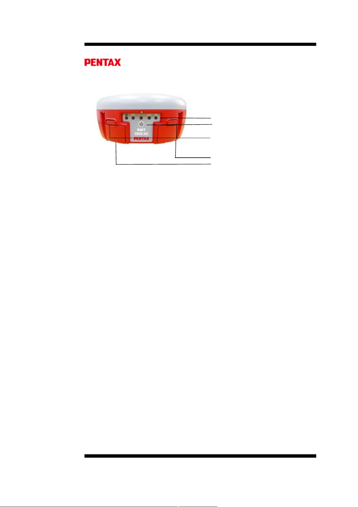
图 1: SMT888-3G 前端面板
LED 状态指示灯
电源键
电池槽打开按钮
A 电池槽
B 电池槽
Page |
Page 8
8
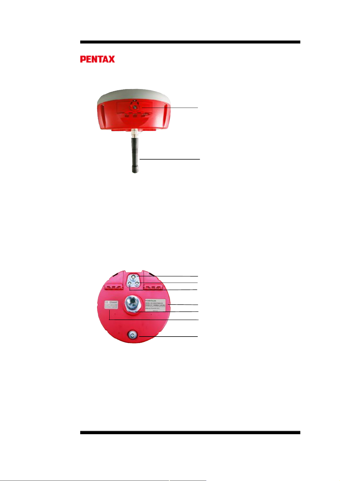
SIM & SD 卡槽
UHF 电台天线
图 2: SMT888-3G, 后视图
从 SMT888-3G 后视图可以看到 SD 卡和 SIM 卡安装的槽门。GNSS 原始数据可
以存储在 SD 卡内,利用内置的 GSM 模块 SIM 卡可以提供手机服务。
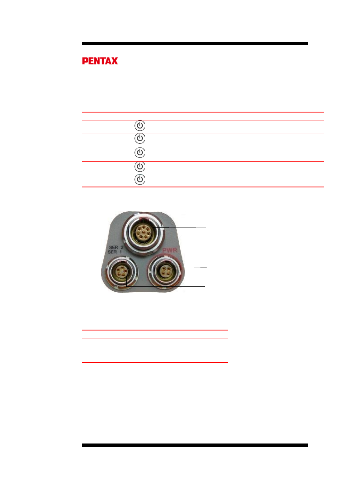
从 SMT888-3G 底部可以看到端口和产品标签,有 3 个端口:两个串行端口和一个
外置电源输入端口。另外还有 TNC 连接器用于安装 UHF 天线,供内置电台使用。中心的
螺纹接头是标准的 5/8“ 接头,用于固定在测量杆或其它配件上。
数据 (8-pin LEMO)
电源 (4-pin LEMO)
控制 (5-pin LEMO)
型号和串号
CE / FCC / Bluetooth® 标签
TNC 连接器
图 3: SMT888-3G 底部视图
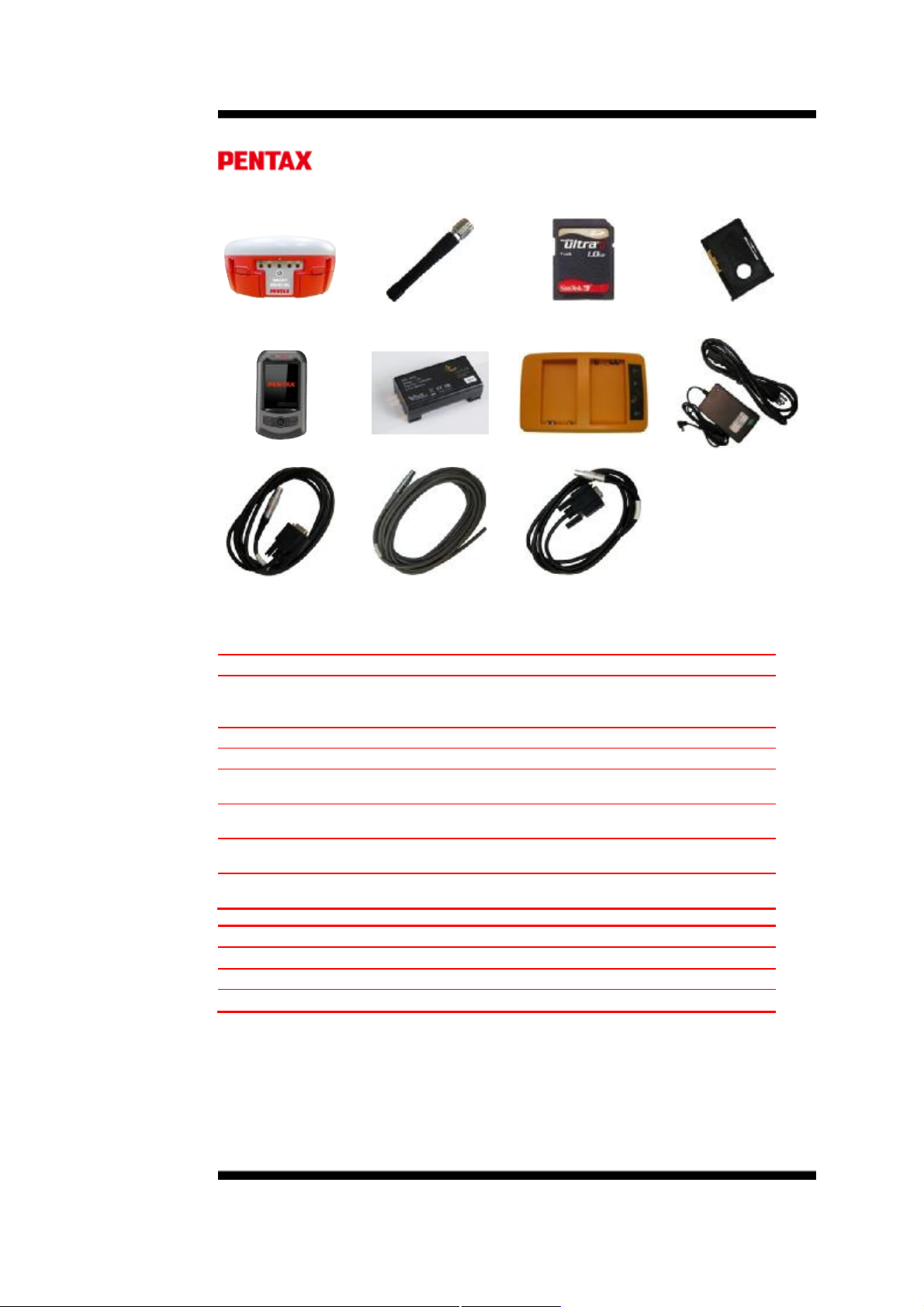
1.2.4. 主机及配件
Page |
Page 9
9
表 2: 详单
SurvCE
SMT888-3G主机
宾得手簿 2 锂电池 电池充电器 交流适配器
数据电缆 电源电缆 控制电缆(可选)
• SIM
完整的 SMT888-3G包含以下条目:
不包含在内
货品条目 用途
超高频天线
锂电池 用于 SMT888-3G 供电
电池充电器 用于锂电池充电
宾得手簿
超高频天线 2GB SD 卡 SIM 卡托
超高频天线接在 SMT888-3G 的 TNC 连接器上以便接
收和发射电台数据。
通过 SurvCE 向 SMT888-3G 发送信息的设备
控制电缆
数据电缆
电源电缆
预装的条目 用途
SD 卡(2G) 存储静态记录数据
SIM 卡托 用于固定及保护 SIM 卡
通过 RS232 连接控制器或电脑
外部通讯设备例如电台和调制解调器
外置 9-15V DC 电源供电
预装在宾得手簿上的 RTK 应用软件
1.2.5. 如何使用您的 SMT888-3G
为了更好的使用,用户在初次使用前应该透彻地理解 SMT888-3G 用户手册。
1.2.6. SMT888-3G 前端面板
Page |
Page 10
10
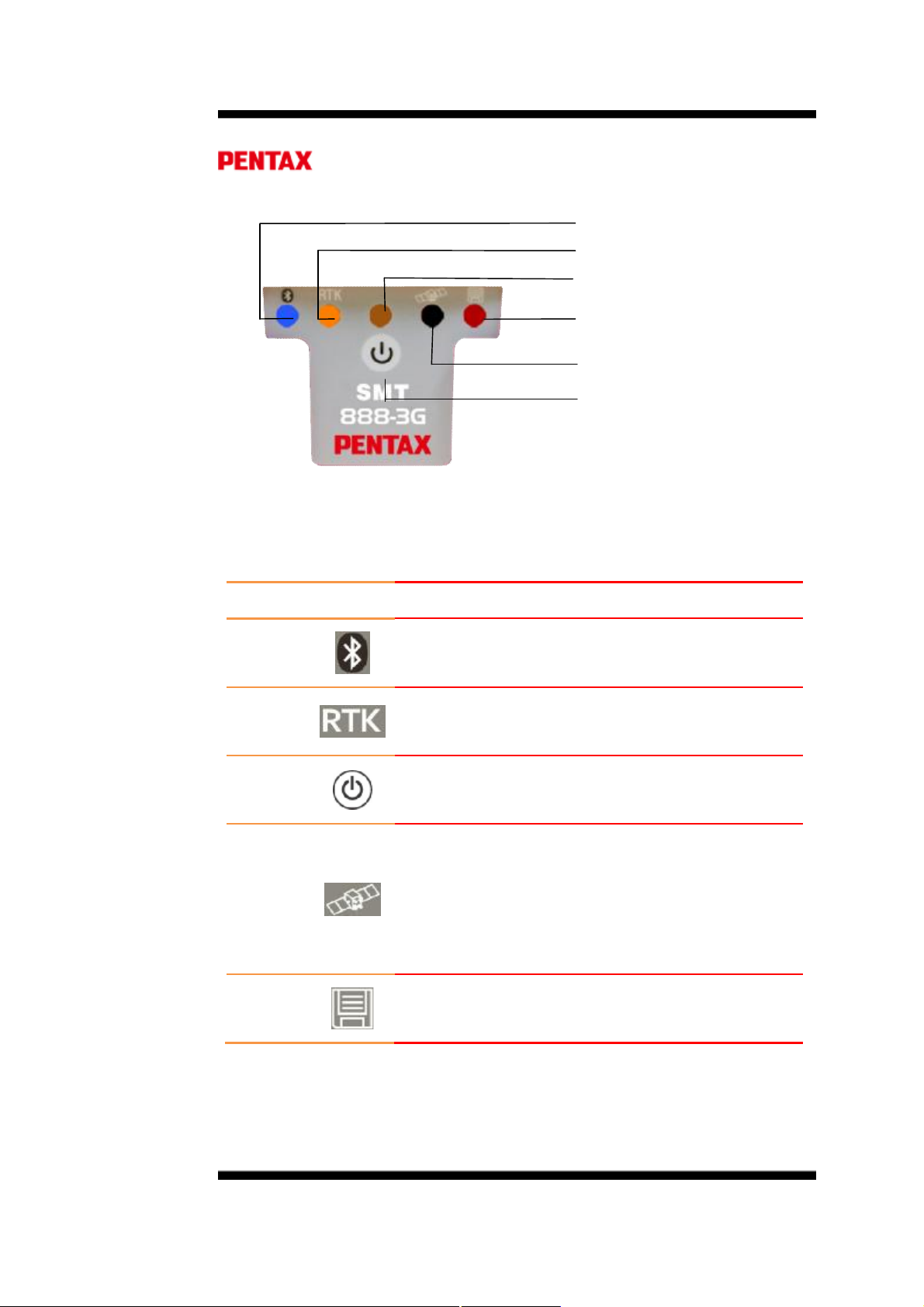
图 4: SMT888-3G 前端面板图
1.2.7. 前端面板说明
表 3: LED 操作
LED
蓝色
桔黄色
红色
蓝牙®
RTK指示灯
电源灯
静态数据记录
GNSS 卫星灯
电源键
图标 状态
开:已和设备建立通讯
关:没有绑定设备
开:RTK 差分信号可用
关:无 RTK差分信号
开:接收机正在工作
关:接收机已关闭
绿色
红色
1.2.8. 电源键
快速连续 (10 次/秒) 0 卫星
闪 1 下,然后暂停 1、2卫星
闪 2 下,然后暂停 3、4 卫星
闪 3 下,然后暂停 5、6 卫星
闪 4 下,然后暂停 7、8 卫星
闪 5 下,然后暂停 9+ 卫星
开:静态数据记录打开
关:静态数据记录关闭
Page |
Page 11
11
电源键位于前端面板上,具备最基本的开关机功能。其次还具备开关静态数据记录
8pin
5pin
4pin
功能、软 启动和硬启动功能。对于软重启,接收机重置固件信息保留当前配置;对于硬重启,
接收机配置信息恢复到默认启动配置。
表 4: 按钮操作
功能
开机
关机
数据记录开/
关
软重启
硬重启
1.2.9. 端口
图 5: 端口说明
按 直到红色 LED 打开
按 4-5 秒然后松开,或着直到电源灯关闭
按 2次,间隔小于1秒,数据记录就会打开或关闭
按 3次,间隔小于1秒,即可软重启
按 4次,间隔小于1秒,即可硬重启
数据 (8-pin LEMO)
串口 2
电源 (4-pin LEMO)
外置
控制 (5-pin LEMO)
串口 1
表 5: 端口说明
LEMO
说明 用途
数据 外置电台
控制 控制器或电脑
电源 外置电源
Page |
Page 12
12
1.2.10. 外接电源
外置电源通过 4-pin Lemo 口供电,规格如下:
功耗:3.6W 典型
外置电源:+9VDC 至 +15VDC
标称电流:300mA @ 12V DC
表 6: 电源电缆说明
电线颜色 功能
红
黑
绿 保留
白 保留
+
-
1.2.11. SIM 卡
表 7: SMT888-3G 后视图
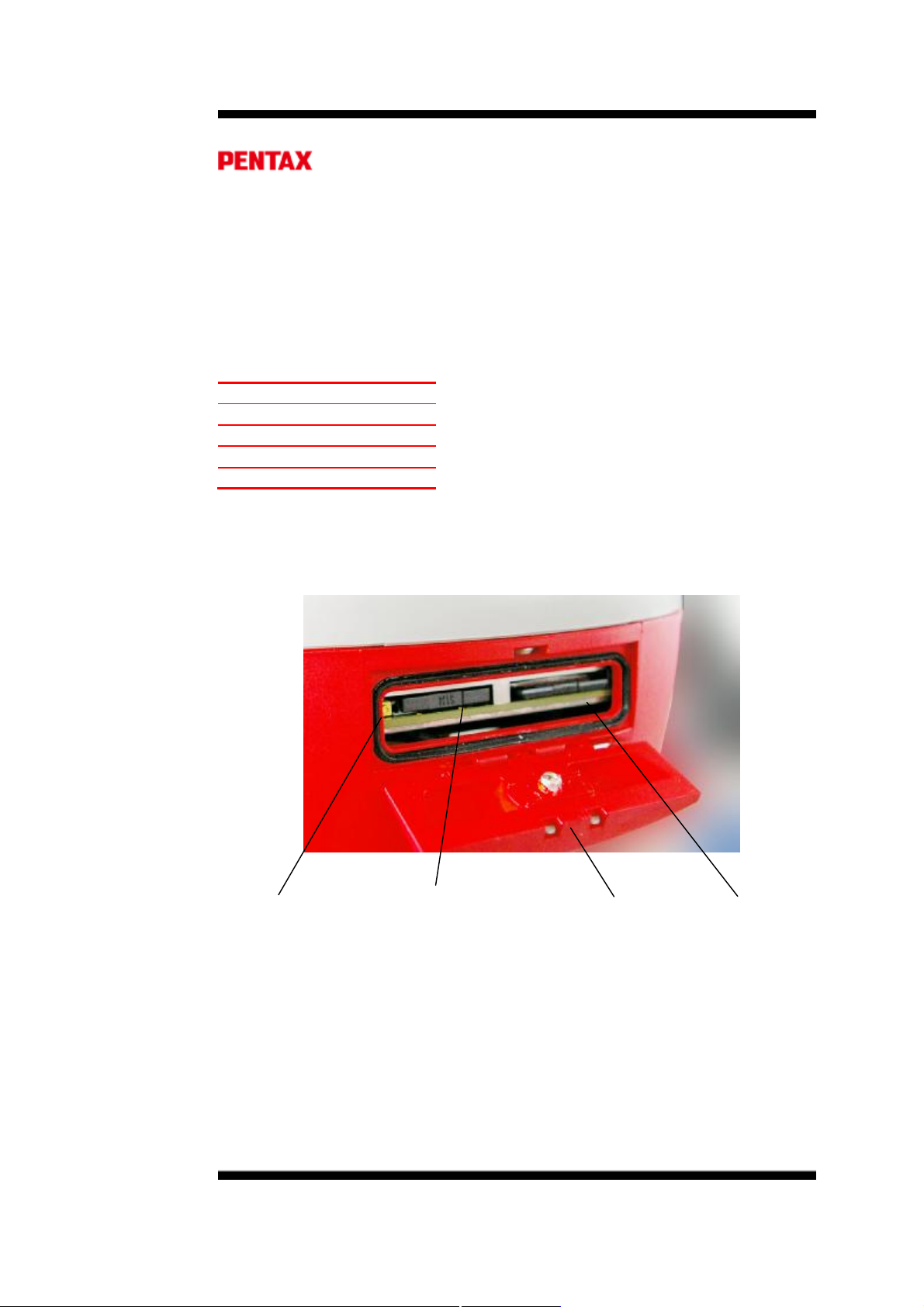
图 6: SIM 卡 & SD 卡 卡槽
SIM 卡托弹出按钮 SIM 卡托 卡槽仓门 SD 卡
1.2.11.1. 购买 SIM 卡
• 手机服务不包含在产品附件当中,需要用户自行购买开通。
¤选择 GSM/GPRS 服务商
¤购买 SIM 卡
¤选择适合您的数据套餐
1.2.11.2. 安装 SIM 卡
Page |
Page 13
13
务必在关机状态下安装或取出
安装/取出 SIM 卡:
• 把圆形卡扣坡口旋转至水平
• 打开仓门
• 按压黄色 SIM 卡托弹出按钮、弹出卡托
• 取出卡托
• 将 SIM卡放置于卡托内
• 将 SIM 卡芯片一面朝下
• 将卡托插入卡槽,同时卡托弹出按钮回到正常位置
SIM
卡,在开机状态下操作会损坏
1.2.12. SD 卡
SMT888-3G 预装 2GB SD卡用于静态数据记录。静态记录的格式为 SBF,可以转
换成 RINEX 格式用于后处理。
SD
卡轻拿轻放,不用时放在仪器内即可,或者取出放置于卡托便于运输、存储
一张 2GB SD 卡以默认的 1Hz的频率记录数据的话,可以工作 8.8 天,内存使用
速度是 9.4 MB/hr。
1.2.12.1. SD卡的使用
务必在关机的状态下安装或移除SD卡,在开机状态下操作可能造成SD卡数据丢
失和损坏
• 打开 SMT888-3G 后部仓门卡扣
• 打开 SIM & SD 卡仓门
• 按压 SD 卡即可解锁
• 从卡槽中取出 SD 卡
• 打开 SMT888-3G 后部仓门卡扣
• 打开 SIM & SD 卡仓门
• SD 卡平放、芯片朝下对准卡槽
• 将 SD 卡推入卡槽就位即可
在使用之前需要 WINDOWS 操作系统格式化 SD 卡
1.2.12.1.1. 移除 SD 卡
1.2.12.1.2. 安装 SD 卡
1.2.12.1.3. 格式化 SD 卡
SIM卡
Page |
Page 14
14
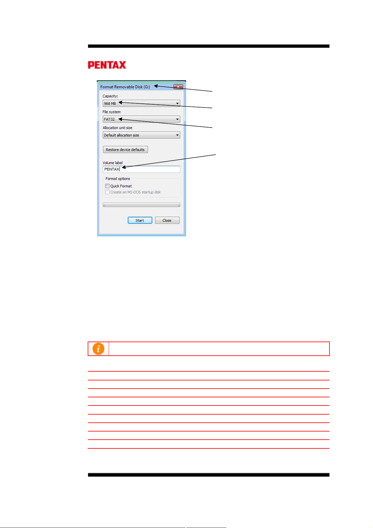
分配的驱动器号(可能不同)
SD 卡容量(1GB)
文件系统
卷标
图 7: SD Card 格式化
• 将 SD 卡放入读卡器
• 系统会识别出可移动设备并分配驱动器号
• 右键点击驱动器号,选择格式化
• 选择文件系统为 FAT32
• 不要勾选快速格式化确认框、以充分格式化 SD 卡
• 点击开始进行格式化
• 完毕之后,确认系统提示“USB Mass Storage Device 可安全移除”之后再从电脑上
取下 SD 卡
1.2.12.1.4. 已知兼容的 SD 卡
不是所有的 SD 卡都兼容 SMT888-3G。以下 SD 已经过
表 8: SD Card 兼容性
容量大小 型号
256MB SanDisk ULTRA II SDSDH-256-901
1GB SanDisk Standard SDSDB-1024-A11
1GB SanDisk Standard SDSDB-2048-A11
1GB Integral
1GB SanDisk Ultra® II SDSDH-1024-901
2GB SanDisk Standard
2GB SanDisk Extreme® III SDSDX3-2048-901
2GB Kingston Ultimate (120x)
Part #
测试并兼容
近似工作时间
~27 hrs / ~1.1 天
~106 hrs / ~4.4 天
~106 hrs / ~4.4 天
~106 hrs / ~4.4 天
106 hrs / ~4.4 天
~212 hrs / ~8.8 天
~212 hrs / ~8.8 天
~212 hrs / ~8.8 天
SMT888-3G
Page |
Page 15

15
• 高容量比如 SDHC 是不支持的
• 低速卡可能导致传输和加载文件过慢,卡内文件过多也会导致同样情况
• 以上兼容的卡可用于 SMT888-3G,仪器本身自带的 SD 卡是我们优先推荐的
您要了解的
我可以用以上列表之外的
卡吗
不能读取并写入数据到
SD 卡
找不到记录的数据 数据记录在 我的电脑/SD 卡(选择对应的驱动器号)
我们着重推荐的卡兼容不会有问题,其它卡尚不清楚
使用可兼容的卡;确保 SD 卡格式化正确
/SSN 文件夹/AsteRx2 文件夹/.SBF 文件
Page |
Page 16
16
2. RTK 操作设置
2.1. 蓝牙® 设置
规格
• Class 1 Bluetooth® ver2.0
• 频率:2.402 ~ 2.48 GHz
• 距离范围:10m – 30m
宾得 PS535 手簿和 SMT888-3G 可以通过蓝牙进行通讯。蓝牙绑定可直接从 SurvCE
来设置。
2.1.1. 宾得 535 蓝牙® 设置 (SurvCE 2.51)
以下设置在 SurvCE 上进行
SurvCEà Equip 标签
图 8: Equip 标签
2.1.1.1. 在 SurvCE 的【设备】标签下选择 GPS 基站 或 移动站
Page |
Page 17
17
图 9: Current 标签
2.1.1.2. 在当前标签下,选择厂商:PENTAX,型号:SMT888-3G
图 10: Comms 标签
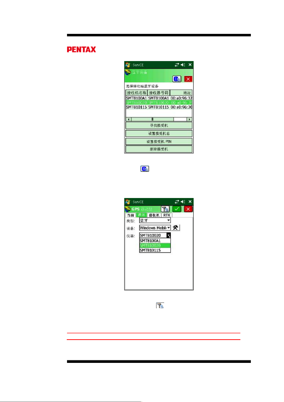
2.1.1.3. 在通讯标签下,选择类型:蓝牙 和 设备:Windows Mobile
Page |
Page 18
18
图 11: 新蓝牙设备
2.1.1.4. 点击 Configure 按钮开始配对不在仪器列表中的主机
2.1.1.5. 每个 SMT888-3G 主机底部有一个独有的编号,如果要连接某台主机必
须使其保持开机状态,在蓝牙设备菜单中选择相应的设备串号绑定即可
通讯
图 12: 蓝牙设备菜单
2.1.1.6. 如果待连接 SMT888-3G 不在设备列表,选择
SMT888-3G
2.1.1.7. 当点击 Find Receiver 之后,SurvCE 就开始搜索蓝牙设备如下图
必须开机才能可见
寻找接收机 进行搜索
Page |
Page 19
19
图 13: 搜索蓝牙设备
图 14: 蓝牙设备列表
2.1.1.8. 从蓝牙设备列表中选择相应的设备串号,如有意外,确认主机处于开机
状态,退出该界面重新搜索即可。选择待连接的设备点击绿色确认框将
其添加到蓝牙设备菜单
Page |
Page 20
20
图 15: SMT888-3G 添加到设备列表
2.1.1.9. 点击蓝牙按钮 ( ) 连接并绑定 SMT888-3G,同时蓝牙指示灯打开。
蓝牙设置完成。
2.1.2. Bluetooth® 和 SMT888-3G (SurvCE 2.08.2)
2.1.2.1. SurvCE 会在仪器列表下记忆之前绑定的 SMT888-3G 名字,在以后的
使用中在仪器下拉菜单中选择即可。
图 16: SMT888-3G 绑定蓝牙®
2.1.2.2. 然后点击蓝牙® 按钮( )和 SMT888-3G 建立连接,蓝牙®指示灯
打开。蓝牙设置完毕。
您要了解的
2.1.2.3.
Page |
Page 21

21
无法绑定SMT888-3G 检查 SMT888-3G 主机底部的串号
绑定主机之后无法与主机
通讯并配置它
电缆连接优先于蓝牙连接,移除控制电缆后重新开始蓝
牙连接。
Page |
Page 22
22
2.2. RTK 基站的配置
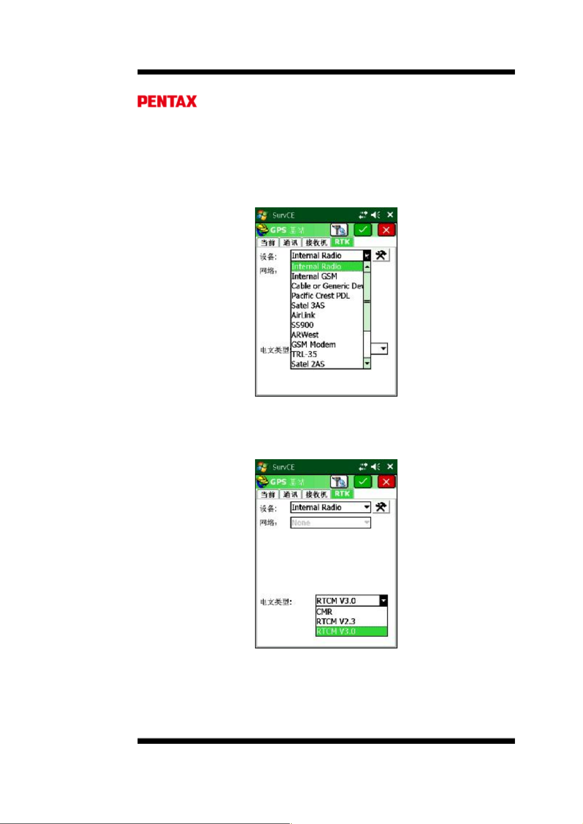
2.2.1. 内置电台的配置
Figure 17: Internal Radio Selection
2.2.1.1.1. 在 RTK菜单下,从设备列表中选择 Internal Radio(内
置电台)
Figure 18: Select Base Message Type
2.2.1.1.2. 从电文格式下拉菜单选择类型:CMR / RTCM V2.3 /
RTCM V3.0。然后点击配置菜单
Page |
Page 23

23
Figure 19: Current Channel Setting
2.2.1.1.3. 选择需要的功率和频道,然后点击确定
将信息设置到电台。
Figure 20: RTK Menu after Radio Configuration
2.2.1.1.4. 在 RTK 菜单下,点击绿色确认键继续下一步基站配置,
SurvCE 将提示输入基站位置,请参考基站的启动。
2.2.2. ARWest 外置电台的配置
Page |
Page 24

24
2.2.2.1.1. ArWest -- AW 435 Radio
Figure 21: RTK Tab
2.2.2.1.1.1. 在 RTK 菜单,从设备菜单选择 ARWest。
Figure 22: Baud Rate Selection
2.2.2.1.1.2. 在波特率菜单选择 115200。
Page |
Page 25

25
Figure 23: Message Type Menu
2.2.2.1.1.3. 选择需要的差分电文格式。
Figure 24: Configure External Base
2.2.2.1.1.4. 点击配置按钮继续外置电台的配置。
Page |
Page 26

26
Figure 25: External Radio Protocol Menu
2.2.2.1.1.5. 选择
协议
/Simplex.
Figure 26: External Radio Power Menu
2.2.2.1.1.6. AW 435可用的最小功率是 25 db (~320 mW),最大
可用功率是 45 db (35 W),根据电台及测量需要选择所
需的数值。
Page |
Page 27

27
Figure 27: External Radio Channel Selection
2.2.2.1.1.7. 选择所需的频道然后点击确认将以上信息设置到电
台。
Figure 28: Device Configured
Page |
Page 28

28
2.2.2.1.1.8. A Device Configured 信息表示配置已发送到电台。
Figure 29: GPS Base Settings
2.2.2.1.2. 在 RTK 菜单下,点击绿色确认键继续下一步基站配置,
SurvCE 将提示输入基站位置,请参考基站的启动。
2.2.3. PDL 外置电台的配置
2.2.3.1.1. Pacific Crest PDL Radio
2.2.3.1.1.1. 选择 SurvCE à
菜单
设备菜单
à GPS
基站
à RTK
Figure 30: External Radio Device Selection
Page |
Page 29

29
2.2.3.1.1.2. 在 RTK菜单,选择
设备
= Pacific Crest PDL.
Figure 31: Baud Rate Selection
2.2.3.1.1.3. 为 PDL 选择所需的波特率。(提示:PDL 支持的最高
波特率是 38400)。
Figure 32: Message Type Selection
2.2.3.1.1.4. 选择所需的差分信号电文类型。
Page |
Page 30

30
Figure 33: Pac. Crest PDL Configuration
2.2.3.1.1.5. 选择配置按钮,继续外置 PDL 电台的配置。
Figure 34: External Pac Crest Radio
2.2.3.1.1.6. 在当前配置页面,选择信号传输的频道,同时选择静
噪=低。然后点击确认继续基站的配置。
Page |
Page 31

31
Figure 35: Device Configured
2.2.3.1.1.7. A Device Configured 信息表示配置信息已发送到
电台。
Figure 36: Complete Base setup
2.2.3.1.2. 在 RTK 菜单下,点击绿色确认键继续下一步基站配置,
SurvCE 将提示输入基站位置,请参考基站的启动。
2.2.4. 基站的启动
Page |
Page 32

32
Quality
of
Base
Position
is
dependent
on
the number
of
samples
taken
(the
Figure 37: Base Position Input
基站位置的确定有两种方式:从未知点和从已知点。
2.2.4.1. 从未知点
2.2.4.1.1. 在屏幕的上部选择从新位置,然后选择所需的方法。例如,
选择从 GPS 读取。
Figure 38: Average GPS for Base Input
2.2.4.1.2. 输入采样次数,按绿色确认键。
more samples averaged the better the quality of the position).
Page |
Page 33

33
Figure 39: Averaged GPS Position
2.2.4.1.3. SurvCE 将显示平均位置 (纬度, 经度, 和大地高)。按
“是”键继续。
Figure 40: Save Base Position to File
2.2.4.1.4. 基站配置成功,点击“ 是 ”键 将 基站设置保存为一个文件。.
Page |
Page 34

34
Figure 41: Base Position File Name
2.2.4.1.5. 给文件命名,点击确认保存并继续。基站配置完成。
2.2.4.2. 从已知点
2.2.4.2.1. 在屏幕上部选择从已知点,然后选择所需要的方法。例如
选择从文件读取,读取之前保存的基站位置来启动基站。
Figure 42: Base Input From Known Position
2.2.4.2.2. 在从已知点菜单,选择从文件读取。
Page |
Page 35

35
Attempting to use a base position from a previously saved position that is more than
Figure 43: Base Station File
2.2.4.2.3. 基站文件打开后显示之前保存的基站文件,选择之后按确
定打开。
5 seconds away from current position will bring up a warning message.
Figure 44: Base Position Input Confirmation
2.2.4.2.4. 之前保存的基站位置被调出,按“是”继续基站配置。
Page |
Page 36

36
Figure 45: Successful Base Station Configuration
2.2.4.2.5. 点击 OK。GPS 基站已经成功配置,差分信号将通过选
择的设备开始发送。
Page |
Page 37

37
2.3. RTK 移动站的配置
配置移动站的话,首先是选择仪器厂商和型号;然 后是选择电缆或者蓝牙作为移动站和
手簿之间的通讯方式;天线高、刷新频率可能也需要配置;最 后 选择电台设备以接收来自基
站的差分信号
图 46: 设备菜单
在 SurvCE设备菜单下,选择 GPS 移动站即会显示移动站菜单。
图 47: 设备选择
在当前标签下选择厂商=PENTAX,型号=SMT888-3G
Page |
Page 38

38
See SurvCE
Update
section
for updates
concerning
users
options
during
图 48: 通讯类型选择
在通讯标签下,选择类型蓝牙
See Establishing Bluetooth® connectivity to bond/pair with SMT888-3G.
图 49: 接收接设置
在接收机标签下用户可以输入天线高、高度截止角、数据更新率。
configuration.
2.3.1. 电台模式的配置
Page |
Page 39

39
Figure 50: RTK Tab
RTK标签用于设置连接到接收机的电台设备,以及网络通讯方式、广播格式。
Figure 51: 内置电台选择
在 RTK标签下从下拉菜单选择内置电台
Page |
Page 40

40
Figure 52: 配置内置电台
选择内置电台后,点击配置按钮
Figure 53 当前频道选择
之前设置的电台功率及频率会显示出来,选择所需的功率(移动站无效)、频率然
后点击绿色确认框将相应设置发给电台。
基站使用内置电台,移动站通讯协议与基站一致即可;
基站使用 ARWEST 电台,则移动站通讯协议使用 Simplex;
基站使用 PDL电台,则移动站通讯协议使用 PDL w/EOT。
Page |
Page 41

41
A valid
data service
SIM card is required
to
use the Internal
GSM
modem.
Refer
配置完电台之后,屏幕退回到 RTK 界面
点击绿色确认框完成移动站的设置,然后屏幕退回到设备菜单如下图
移动站配置已完毕。点击星空图查看移动站状态。
2.3.2. 网络模式的配置(VRS,GPRS 点对点)
配置主机上网
Figure 54: 配置完电台之后的屏幕
Figure 55: 设备菜单
to the SIM card instructions for installation and service plan setup.
Page |
Page 42

42
Figure 56: Internal GSM
在 RTK 标签下从设备下拉菜单选择 Internal GSM。然后点击 Configure 配置 GSM
服务商信息。
Figure 57: APN Server Name
从拉菜单选择手机运营商,大陆选择其它,数字。点击设置,APN 服务器输入
CMNET。然后点击绿色确认框完成。
CORS 网络的设置
Page |
Page 43

43
Figure 58: NTRIP Selection
在 RTK 菜单,网卡列表选择 NTRIP 。
Figure 59: NTRIP & Message Type
点击网络配置按钮,打开 NTRIP 广播菜单。
Page |
Page 44

44
选择已有的网络名称,或者新建网络名称输入 IP、端口、用户名和密码,然后点击
确认进行下一步。
连接成功后,CORS基站信息被加载。用户可以从下拉菜单选择所需的源节点。
Figure 60: NTRIP Broadcast Access
Figure 61: NTRIP Caster Selection
为了达到良好的效果,选择包含 GPS+GLONASS 的源节点,选择完毕之后点击确
定回到 RTK 菜单
Page |
Page 45

45
点击确定,启动移动站
GPRS 点对点通讯
如图
基站设置 移动站设置
在 RTK菜单,网络列表中:
对于基站选择 TCP/IP Network
对于移动站选择 TCP/IP Direct 。然后点击配置按钮,输入对应的 IP、端口。
Page |
Page 46

46
上海服务器 IP:116.236.250.45
基站 1: 6790 移动站 6791
基站 2: 6792 移动站 6793
基站 3: 6794 移动站 6795
输入网络名称,IP 地址,端口。对于之前使用过的网络,可以从名称下拉菜单中调
出。点击确定进行下一步。回到 RTK 菜单后,点击确定启动移动站。
移动站的端口必须和基站对应;如果有两台移动站,都使用相同的端口。
Page |
Page 47

47
3. RTK 应用软件 SurvCE 的使用
3.1. 创建项目及投影设定
在文件菜单下,点击项目菜单可打开已有项目,或创建新的项目:
图3.1.1 图3.1.2
在名称一栏输入项目名称,点击确定即可创建新的项目,新的项目默认使用上次项
目的设定:
图3.1.3 图3.1.4
Page |
Page 48

48
距离单位采用公制(米),角度单位采用度分秒,0 方向为北方向,如图 3.1.3。对
于投影设定,要根据当前测量区域和使用的坐标系统设置相应的投影参数,点击编
辑投影列表(Edit Projection List)设定投影,如图 3.1.4。用户可以自定义北京 1954
或西安 1980 或其他的坐标系统,也可以选择预定义的北京 1954 的坐标系统,预定
义的坐标系统为 6°带。
3.2. 点校正
投影设定完毕之后,在开始测量工作之前,一般来说我们都需要进行点校正。点校
正的实质就是计算椭球之前的转换参数,把 RTK 的测量数据转换到我们的施工坐标
系上面来。
其步骤:首先逐个采集参与校正的控制点坐标,然后到点校正菜单下将每一个控制
点的当地坐标(已知)与相应的测量数据匹配起来。
采集完毕控制点之后,打开设备菜单下的点校正菜单,如图 3.1.5,选择点校正,图
3.1.6。
图3.1.5 图3.1.6
点击添加,选择控制点已知坐标,然后点确定,图 3.1.8,从原始文件读取,选取在
该控制的测量坐标。
Page |
Page 49

49
图3.1.7 图3.1.8
从点列表中选择测量坐标后,点击确定,一组控制点添加完毕。
图3.1.9 图3.1.10
如法炮制,添加第二、第三个控制点。所有校正点添加完毕后,点击保存按钮,保
存校正结果,对于新建的项目可以加载该校正结果直接使用;同样,对于 1+N 的配
置,其他移动站也可以直接加载该校正文件直接进行测量工作,避免重复劳动。
参与校正的控制点至少要求两个,如果对于高程精度要求较高,则至少要求 3-4 个
控制点,且控制点的选择避免呈线型分布。
Page |
Page 50

50
3.3. 坐标采集
选择测量菜单,存储点即为坐标采集功能
图3.1.11 图3.1.12
点击保存按钮,保存当前位置。保存的点可以通过点击界面左上方的头盔快捷键查
看。
图3.1.13 图3.1.14
3.4. 坐标放样
选择测量菜单下的放样点,选择待放样的点,依据屏幕指示完成放样工作。
Page |
Page 51

51
图3.1.15 图3.1.16
3.5. 放样道路
对于道路的放样,可以在手簿上输入线路参数,然后输入里程和偏距来放样中桩和
边桩。线路参数的输入及预览如图
图3.1.17 图3.1.18
线路参数录入完毕后,进入测量菜单下的放样线/弧,选择定义路线
Page |
Page 52

52
选择定义的线路文件
输入要放样的桩号,设定放样点的间隔。如果是边桩,设定偏距。
Page |
Page 53

53
依据屏幕指示放样完成中边桩的放样。
3.6. 数据导出导入
在文件菜单下,点击导入/导出,选择导出 Ascii 文件
设定要导出的坐标顺序,通常导出格式:点号,北,东,高程,描述。设定完毕之
后点击确定
Page |
Page 54

54
注意文件的保存位置,将手簿与电脑同步后,将该文件拷贝到电脑即可。
导出的数据示例如图:
Page |
Page 55

55
该数据导入南方CASS 方法如下:
a. 运行 Length500 数据传输转换软件,进入数据转换菜单下的自由转换
Page |
Page 56

56
b. 根据转换前的数据格式:点号,X,Y,Z,代码,按下图设定
Page |
Page 57

57
c. 设定完毕后点击输入文件名按钮,选择转换前的文件;然后点击输出文件名,
设置转换后的文件名及位置。设置完毕后提示转换完成。
d. 打开转换后的文件,如图 已转换为 CASS 格式
Page |
Page 58

58
数据导入的方法与导出是类似的,请用户自行尝试。
4. 静态操作及数据转换
4.1. 启动静态
运行 SurvCE 软件 Survey 菜单下的记录 GPS 原始数据将静态数据记录到 SD 卡上。
另外一种启动静态的方式是双击电源键,间隔小于 1 秒,即可开始记录静态数据。
必须在关机状态下插拔SD卡
Page |
Page 59

59
Figure 62: Log Raw GPS
4.1.1. 在测量菜单下,选择 7 记录 GPS 原始数据。
Figure 63: Log GPS Menu
4.1.2. 选择开始文件。
Page |
Page 60

60
Figure 64: Raw File Menu
4.1.3. 输入文件名,设置采样间隔后确定。
Figure 65: Log Raw Data On
4.1.4. 红色静态指示灯打开。The RED Logging LED will turn ON. The SBF file
name is displayed followed by (logging) to indicate data is being written to
the SD card. Select Close File to end data logging or click the icon to
close the window and simultaneously perform other operations while
continuing logging.
务必先关机再取出SD卡。
4.2. 数据转换
Page |
Page 61

61
SD 卡记录的静态数据格式为 SBF,首先我们要其转换为 RINEX格式,转换需要
用到 SBF Converter软件。软件可到励精科技网站下载。
转换步骤:
1. 运行 SBF Converter,选择要转换的数据或文件夹:
2. 勾选 RINEX,点击 Options,设置如图:
Page |
Page 62

62
点击Obs options,观测选项,设置如下:
设置完毕之后,点击 Convert 开始转换:
Page |
Page 63

63
转换完毕后,即可将 RINEX 格式数据导入后处理软件进行解算。
Page |
Page 64

64
5. SMT888-3G 设备 & 规格
5.1 内置电台
规格
• 工作频率: 403MHz - 470 MHz
• 占有频宽: 6.25kHz, 12.5kHz or 25kHz
• 增益: 145-146dBm
您需要了解的
如何配置内置电台 内置电台出厂时已配置好,一 般来讲是不需要客户
移动站收不到差分信号
5.2GSM 调制器
规格
• Quad band GSM/GPRS Class 10 Radio Device for true Global usage
• GSM 850/900MHz power class 4 (33dBm)
• GSM 1800/1900MHz power class 1 (30dBm)
5.2.1 通讯协议
• TCP/IP
• UDP/IP
• Direct Dial
您需要了解的
我们国家使用的频段是
什么?
GSM 调制器 确认 SIM 卡适用于数据上网
无法连接到 RTK 网络 检查参考站的通讯协议
900/1800MHz 北美 (美国,加拿大)
850/1900MHz 国际 (欧洲,亚洲,拉丁美洲)
配置的。如果要改变内置电台频率等信息,需要
AWlanch 软件来配置。
检查基站配置,确保基站能接收到 6 颗以上卫星;
检查移动站配置,确保移动站使用相应的电文格
式、通讯协议及频道。
Page |
Page 65

65
5.3 电池 & 充电器
SMT888-3G 配备两块可充锂电池,标称工作时间 8-10 小时。
规格
电池类型:锂电
电压: +6.2VDC 至 8.4VDC
容量: 2500mAH
5.3.1 电池充电器
AC 适配器
输入: 100-240VAC ~50/60Hz 1.7A
输出: 19.0VDC @ 3.16A
5.3.2 充电
图 9: 电池充电说明
电池仓 1
电池仓 2
LED 状态指示:
• 电池仓 2
• 电池仓 1
充电器电源
• 连接电源线到 AC 适配器
• 连接 AC 适配器到电池充电器,电源指示灯变亮
• 将电池正确地放入电池仓
• 等待电池指示灯变绿,表示电池充满
LED
关 电池没有放置正确
绿 电池已充满
红 电池正在充电
说明
充满电通常需要2个小时左右。
5.3.3SMT888-3G 电池安装
Page |
Page 66

66
不要取下正在使用的电池. 更换正在使用的电池可能会导致
SMART8800-3G
的电池。
• 按下仓门按钮打开电池仓
• 电池字面朝上将电池插入仓内
• 用力合上电池仓门,听到卡扣声表示已扣上。
重启或关机
.
使用
SurvCE
5.3.4 查看电池状态
使用
SurvCE
可以查看电池状态, 当使用外接电源时,不可以查看。
下的电池状态查看“正在使用”
Figure 66: Equip Menu
在设备菜单下,点击基站或移动站。
Page |
Page 67

67
Figure 67: Equipment Selection
在当前菜单,选择厂商=Pentax,型号=SMT888-3G。
在当前菜单,点击 图标即可显示电池使用情况。
Figure 68: GNSS Firmware & Battery Status Display
1.1.1.1.1. 点击 图标退出显示。
您需要了解的
一块电池能用多久? 4 - 5 小时
当其中一块电池用尽,接收
机如何切换到另一块电
池?
在使用过程中,可以拔掉其
中一块电池吗?
自动切换,不需要用户操作
可以,但最好使用手簿查看一下,拔掉没有使用的那块
Page |
Page 68

68
电池充满电需要多久? 2 个小时
我怎么知道电池已充满? 每块电池对应的绿色指示灯表示电池已充满
Page |
Page 69

69
常见问题解答
1.2. Question: Where is the Antenna Reference Point (ARP) located on the
SMT888-3G?
Answer: The NGS ARP is the bottom of the bolt on the underside of the
SMT888-3G. The NGS calibration value for the SMART8800-3G L1 vertical
offset is 113.5 mm. For more information visit is:
Figure 69: NGS ARP Diagram
1.3. Question: Does the SMT888-3G L1 vertical offset need to be added to the
measured height to the bolt?
Answer: No, SurvCE recalls the vertical offset automatically when the
SMT888-3G is selected.
Figure 70: NGS Calibration adjustment
Page |
Page 70

70
1.4. Question: How do I know which battery I can remove without having
operations interrupted?
Answer: Use SurvCE to distinguish which battery is in use by following the
steps described in section 4.3.4. from the Equipment menu.
1.5. Question: How do I make the push button logging files increment rather
than appending once SurvCE has been used?
Answer: Send the increment command via the Send File utility, which and
be located via SurvCE à Equip Tab à GPS Utilities à Send Command.
Then enter: setFileNaming, DSK1, Incremental, PENTAX.
1.6. Question: How do I configure a unit back to the PENTAX factory defaults?
Answer: Located on the PENTAX CD there is a text file called “AsteRx2
PENTAX Default 04152009 Config.txt.” Follow the Factory AsteRx2 receiver
Settings section 5 of this manual to upload that file into the SMT888-3G.
1.7. Question: What are the correct specifications for a GSM SIM card in order
for it to operate with the SMT888-3G?
Answer: There are three key items that must be specified to get the correct
GSM SIM card and service from your cellular service provider;
1. GSM SIM card (not UMTS)
2. Data service only
3. No IMEI number (i.e. no associated hardware/handset)
SIM cards that had one or more of the above 3 features incorrect did not
work. In the USA, AT&T and T-Mobile provide GSM SIM cards that have been
used successfully with the SMT888-3G.
1.8. Question: Why am I not receiving GLONASS corrections?
Answer: You must first verify that the base station transmits GLONASS
corrections. The SMT888-3G first utilizes GPS satellites to get to RTK Fixed
status. Then if more than 2 acceptable GLONASS satellites are available, RTK
Fixed GPS+GLO RTK status is achieved.
1.9. Question: Why is my radio not receiving RTK corrections?
Answer: Check Base Station Configuration. Make sure that Base Station
receiver is set up and using more than 5 common Satellites. Check Rover
Configuration; make sure that it is configured to use the correct RTK format
corrections. Both Base Station and Rover must use the same UHF Radio Channel
and same correction format.
1.10. Question: How do I know which message type to select RTCM V2.3,
RTCM V3.0, CMR, or CMR+?
Answer: Base stations transmit different messages types. It is important
to confirm what message type(s) the base is transmitting so the Rover can be
set accordingly. SurvCE allows the Message types for some base stations to
be identified directly in SurvCE.
Page |
Page 71

71
1.11. Question: How can I verify the Windows Mobile® version my hand held
device is operating on?
Answer: In the main view of the controller, select the Start Menu, next click
Settings Menu, then select the System tab, lastly select the About icon
which will display the Windows Mobile® version.
1.12. Question: How do I delete points that have been stored in SurvCE?
Answer: One way to delete points is to go to the File tab and select the
Points button. Once in the Points Menu select the point and click delete.
1.13. Question: How do I change my settings in SurvCE to use metric,
International Feet, or US Survey Feet for the distance?
Answer: These settings must be set when starting a new job. In the File
tab select Job Settings, then select the System tab and choose the Distance
Units from the drop down menu.
1.14. Question: How do I stop the SMT888-3G from logging automatically on
startup?
Answer: The SMT888-3G remembers the settings set during the last
configuration and uses these upon restart. To stop logging upon startup,
Close the Data File and reconfigure the base/rover. Reconfigure by selecting
the green check mark on GPS Base/Rover tab.
1.15. Question: I can’t connect to the SMT888-3G via Bluetooth®, why not?
Answer: Make sure that the serial cable (SER1) is disconnected. The
serial cable takes precedence to Bluetooth® connectivity, and because of this
Bluetooth® is unable to connect when the cable is attached. Also verify the
Bluetooth® is ON/Visible on the controller (Archer, Allegro CX, or Allegro MX).
See Bluetooth® section for setup.
1.16. Question: How do I update my data collector to the latest Software
version?
Answer: Download the SurvCE version at http://www.survce.com/
approved by Altus. Connect the data collector to a PC (via Serial or USB
connection). Use Active Sync to synchronize files by checking the files box,
then run the latest SurvCE version executable and perform the tasks as
directed on the screen. Once completed, software version can be verified in
the “Equip” tab of SurvCE in the “About SurvCE” menu. If the version is not
on the website, contact PENTAX Support.
1.17. Question: I noticed that the units get extremely hot at the top, what
effect might this have on any operations?
Answer: The SMT888-3G is designed to operate reliably from -20 to +65 °C.
Like most manufacturers, we test beyond that limit to ensure we can operate
at the published extremes.
Page |
Page 72

72
1.18. Question: What can be expected in the potential 2010 GPS meltdown?
Answer: The GPS constellation is well over 25 years old now [not all birds].
There have been delays in launching newer technology birds, but it doesn't
necessarily mean the older satellites will shut down; it doesn't mean they
won't either! Worst Case: DOD requires 95% probability of 24 satellites at
any given time. Best Case: The existing satellites will last 20 more years
before shutting down and something new and improved will take its place.
1.19. Question: How do I update the SMT888-3G to the latest firmware
version?
Answer: Get the latest firmware release from Altus. Connect the 5 pin
controller serial cable (SER1) to the bottom of the SMT888-3G, connecting
the DB9 side of the cable to a PC’s RS232 serial port. Power on the
SMT888-3G and open RxControl. Once connected to the SMT888-3G click
the tools tab and select upgrade receiver. Click Ok to close connection.
Then click “Next” in the RxControl Upgrade Wizard. Next select the COM
port used for the connection between the SMT888-3G and computer
followed by clicking “Next”. Locate the appropriate SUF file, and click
“Next”. Then select “Upgrade”, and proceed with any other on screen
directions. Once completed, firmware version can be verified in the “Help”
tab of RxControl in the “Receiver Identification” menu. It can also be
checked in SurvCE, follow “viewing battery status” section 4.3.4 where the
firmware can also be identified.
Page |
Page 73

73
常见 GNSS 相关缩写
APME A Posteriori Multipath Estimation
ARP Antenna Reference Point
ASCII American Standard Code for Information Interchange
CMR Compact Measurement Record
CPU Central Processing Unit
CR Carriage Return
CTS Clear to Send
DGPS Differential Global Positioning System
DOP Dilution of Precision
EGNOS European Geostationary Navigation Overlay System
ESTB EGNOS System Test Bed
FPGA Field Programmable Gate Array
GLONASS Global Orbiting Navigation Satellite System (Russian alternative for GPS)
GNSS Global Navigation Satellite System
GPRS General Packet Radio Service
GPS Global Position System
GPX GPS eXchange
GSM Global System for Mobile communications
GUI Graphical User Interface
HERL Horizontal External Reliability Level
HPL Horizontal Protection Level
IGS International GNSS Service
LAMBDA Least-squares Ambiguity Decorrelation Adjustment
LED Light Emitting Diode
MDB Minimal Detectable Bias
MOPS Minimum Operational Performance Standards
MSAS Multi-functional Satellite Augmentation System
MT Message Type
NGS National Geodetic Survey
NMEA National Marine Electronics Association
OEM Original Equipment Manufacturer
OTF On the Fly
PPS Pulse Per Second
PVT Position Velocity Time
RAIM Receiver Autonomous Integrity Monitoring
RINEX Receiver INdependent Exchange Format
ROM Read Only Memory
RTCA Radio Technical Commission for Aeronautics
RTCM Radio Technical Commission for Maritime Services
RTK Real Time Kinematic
SBAS Satellite Based Augmentation System
SD Secure Digital
SDHC Secure Digital High Capacity
SIM Subscriber Identity Module
UHF Ultra high frequency
VRS Virtual Reference Station
WAAS Wide Area Augmentation System
Page |
 Loading...