

Page 1

2018
For your safety, read carefully and keep in this vehicle.
NI S SA N CO N NE C T
OWNER’S MANUAL
®
Page 2

(4,1)
NISSAN CONSUMER AFFAIRS DE-
PARTMENT
For assistance or inquiries about the
NISSAN Navigation System, NISSAN warranty, service or general questions, contact the NISSAN Consumer Affairs
Department at:
For U.S. customers
Nissan North America, Inc.
Consumer Affairs Department
P.O. Box 685003
Franklin, TN 37068-5003
1-877-NOGASEV
1-877-664-2738
For Canadian customers
Nissan Canada Inc.
5290 Orbitor Drive
Mississauga, Ontario L4W 4Z5
1-800-387-0122
NISSAN NAVIGATION SYSTEM
HELPDESK CONTACT INFORMATION
To order updated map data, contact the
NISSAN NAVIGATION SYSTEM HELPDESK
at:
. E-MAIL: nissan-navi-info@here.com
. WEBSITE: www.NissanNavigation.com
. PHONE: 1-888-661-9995
NISSANCONNECT® EV AND SERVICES CUSTOMER SERVICE
. WEBSITE for U.S. customers:
www.NissanUSA.com/connect
. WEBSITE for Canadian customers:
www.Nissan.ca/NissanConnect
(English)
www.Nissan.ca/NissanConnect/fr
(French)
. E-MAIL:
nissanownerservices@nissan-usa.
com
. PHONE:
1-877-664-2738
. HOURS:
Mon-Sat, 8:00 AM to 12:00 AM (Eastern
Standard Time)
Page 3

FOREWORD
. Navigation
. Voice recognition
. Information and settings viewable on
the system
Please read this manual carefully to ensure safe operation of NissanConnect®
with Navigation, EV and Services.
. Because of possible specification
changes and optional equipment,
some sections of this manual may
not apply to your vehicle.
. All information, specifications and il-
lustrations in this manual are those in
effect at the time of printing. NISSAN
reserves the right to change specifications or design at any time without
notice.
. Do not remove this manual from the
vehicle when selling this vehicle. The
next user of the system may need the
manual.
Thank you for purchasing a NISSAN vehicle.
This user’s manual is for NissanConnect®
with Navigation, EV and Services offered in
your NISSAN vehicle.
Operation instructions for the following
systems are included in this manual.
. EV-specific functions
. Audio
. Hands-Free Phone
. NissanConnect® EV and Services
. Apple CarPlay
. Android Auto
TM
TM
Page 4

Page 5

Table of Contents
Safety information................. 3-3
Map operation .......................... 3-3
Setting destination.............. 3-16
Route guidance...................... 3-31
Viewing traffic
information............................... 3-49
Storing a
location/route........................ 3-52
Navigation settings............ 3-60
Telematics overview ............ 5-2
NissanConnect® EV and
Services .......................................... 5-4
NissanConnect® EV and
Services menu.......................... 5-11
Emergency support............ 5-15
NissanConnect® EV and
Services settings ................... 5-17
Error message on
communication...................... 5-21
0 Introduction
How to use this manual.... 0-2
Safety information................. 0-3
Trademarks................................ 0-4
Regulatory information ..... 0-6
Licenses......................................... 0-8
IT System overview
System features ..................... IT-2
1 Getting started
Control buttons and
touch screen display ............ 1-2
Starting system......................... 1-6
Basic operation ......................... 1-7
System settings ...................... 1-15
2 Unique EV functions
Zero Emission menu
screen.............................................. 2-2
Displaying estimated
driving range and
charging station
information.................................. 2-3
Energy usage information
display ............................................. 2-8
Unique EV function
settings........................................... 2-9
3 Navigation
4 Audio system
Audio operation
precautions ................................. 4-2
Names and functions
of audio control
buttons ........................................... 4-8
Audio operations .................... 4-9
Audio settings ........................ 4-26
5 NissanConnect® EV and Services
Page 6

6 Viewing information
Voice recognition ................... 8-2
Customer assistance......... 10-2
System unit ............................... 10-3
Unique EV functions........... 10-5
Audio system .......................... 10-8
Bluetooth®
Hands-Free Phone
System ........................................ 10-15
NissanConnect® EV and
Services ...................................... 10-18
Navigation ................................ 10-19
Voice recognition .............. 10-26
Apple CarPlay
Information menu.................. 6-2
SiriusXM Travel Link.............. 6-7
Apple CarPlay
equipped)...................................... 6-9
Android Auto
TM
(if so
TM
...................... 6-12
How to handle display ..... 9-13
How to handle the SD
card.................................................. 9-14
How to handle USB
memory........................................ 9-15
10 Troubleshooting guide
7 Hands-Free Phone
Bluetooth®
Hands-Free Phone
System ............................................ 7-2
8 Voice recognition
9 General system information
Current vehicle location.... 9-2
Route calculation.................... 9-6
Route guidance........................ 9-8
Map data ....................................... 9-9
equipped)................................. 10-29
Android Auto
TM
(if so
TM
.................. 10-30
Page 7

0 Introduction
How to use this manual .......................................................... 0-2
For safe operation ................................................................. 0-2
Reference symbols ................................................................ 0-2
Screen illustrations ............................................................... 0-2
Safety information ....................................................................... 0-3
Trademarks ....................................................................................... 0-4
Regulatory information ........................................................... 0-6
Laser product ......................................................................... 0-6
Bluetooth® devices ............................................................. 0-6
Licenses ............................................................................................... 0-8
Telematic Control Unit Gen2K .................................. 0-8
Page 8
0. Introduction
HOW TO USE THIS MANUAL
This manual uses special words, symbols,
icons and illustrations organized by function.
Please refer to the following items and
familiarize yourself with them.
FOR SAFE OPERATION
WARNING
This is used to indicate the presence
of a hazard that could cause death or
serious personal injury. To avoid or
reduce the risk, the procedures must
be followed precisely.
CAUTION
This is used to indicate the presence
of a hazard that could cause minor or
moderate personal injury or damage
to your vehicle. To avoid or reduce the
risk, the procedures must be followed
carefully.
NOTE:
Indicates items that help you understand and maximize the performance of
your vehicle. If ignored, they may lead to
a malfunction or poor performance.
REFERENCE SYMBOLS
INFO:
This indicates information that is necessary for efficient use of your vehicle or
accessories.
Reference page:
This indicates the title and page that you
should refer to.
<>:
Indicates a button on the control panel.
[]:
This indicates a key/item displayed on the
screen.
Voice Command:
This indicates an operation by voice
command.
SCREEN ILLUSTRATIONS
. The illustrations in this manual are
representatives of various models
and may not be identical with the
design and specifications of your vehicle.
. Icons and menu items displayed on
the screen may be abbreviated or
omitted from the screen illustrations
when appropriate. The omitted icons
and menu items are described as
dotted lines as illustrated.
0-2
Page 9
. To operate the system, first park
the vehicle in a safe location and
set the parking brake. Operating
the system while driving can distract the driver and may result in a
serious accident.
. Exercise extreme caution at all
times so full attention may be
given to vehicle operation. If the
system doesn’t respond immediately, please be patient and keep
your eyes on the road. Inattentive
driving may lead to a crash resulting in serious injuries or death.
. Do not rely on route guidance
alone. Always be sure that all
driving maneuvers are legal and
safe in order to avoid accidents.
. Do not disassemble or modify this
system. If you do, it may result in
accidents, fire or electrical shock.
. If you notice any foreign objects in
the system hardware, spill liquid
on the system or notice smoke or a
smell coming from it, stop using
the system immediately and contact a NISSAN certified LEAF dealer.
Ignoring such conditions may lead
to accidents, fire or electrical
shock.
0. Introduction
SAFETY INFORMATION
This system is primarily designed to help
you support pleasant driving as outlined
in this manual. However, you, the driver,
must use the system safely and properly.
Information and the availability of services
may not always be up to date. The system
is not a substitute for safe, proper and
legal driving.
Before using the system, please read the
following safety information. Always use
the system as outlined in this manual.
WARNING
CAUTION
. Some jurisdictions may have laws
limiting the use of video screens
while driving. Use this system only
where it is legal to do so.
. Extreme temperature conditions
[below −4°F (−20°C) and above
158°F (70°C)] could affect the performance of the system.
. The display screen may break if it
is hit with a hard or sharp object. If
the display screen breaks, do not
touch it. Doing so could result in an
injury.
NOTE:
. Do not keep the system running with
the READY to drive indicator light
OFF. Doing so may discharge the 12volt battery. When you use this system, always make sure the READY to
drive indicator light is ON.
. Completing the NissanConnect® EV
and Services registration is necessary to use NissanConnect® EV and
Services related functions. NissanConnect® EV and Services may not be
available in some regions.
. To check the Li-ion battery charging
status or to use the remote heater
and air conditioner using an internet
enabled smart phone or personal
computer, the following conditions
must be met:
— The vehicle must be located in a
cellular phone or smart phone
coverage area.
— The internet enabled cellular
phone or smart phone must be
located in a cellular phone or
0-3
Page 10

smart phone coverage area.
— The computer must be connected
to the internet.
— A cellular phone must be used to
communicate with the vehicle.
— A cellular phone capable of text
messaging must be used to receive text message regarding vehicle charge status.
. When the remote heater and air
conditioner is set, the system operates the heater and air conditioner to
adjust the in-cabin temperature to a
set temperature.
. When the charge connector is dis-
connected from the vehicle, the heater and air conditioner operates
using vehicle Li-ion battery electric
power.
. If the remote heater and air condi-
tioner function and Li-ion battery
charging are performed at the same
time, Li-ion battery charging will
take longer than usual due to the
power used to heat or cool the
vehicle.
. Certain remote functions require a
compatible smart phone, which is
not included with vehicle.
. NissanConnect® EV and Services in-
formation system features are included through a subscription
service which requires owner consent to activate. The subscription
must be active to use these features.
. NissanConnect® EV and Services
communications may be received at
a verified e-mail address or by SMS/
text messaging-enabled cellular
phone.
. Standard text rates and/or data
usage may apply depending on your
carrier.
0. Introduction
0-4
TRADEMARKS
Windows® and Windows Media® are registered trademarks or trademarks of Microsoft Corporation in the United States of
America and/or other countries.
Windows Media Player:
This product is protected by certain
intellectual property right of Microsoft.
Use or distribution of such technology
outside of this product is prohibited without a license from Microsoft.
“Made for iPod” and “Made for iPhone”
mean that an electronic accessory has
been designed to connect specifically to
iPod® or iPhone®, respectively, and has
been certified by the developer to meet
Apple performance standards. Apple is
not responsible for the operation of this
device or its compliance with safety and
regulatory standards. Please note that the
use of this accessory with iPod® or
iPhone® may affect wireless performance.
Apple, the Apple logo, iPhone®, iPod®, iPod
classic®, iPod nano®, and iPod touch® are
trademarks of Apple Inc., registered in the
U.S. and other countries. Lightning is a
trademark of Apple Inc. App Store is a
Page 11

0. Introduction
service mark of Apple Inc.
The Bluetooth® word mark and logos are
registered trademarks owned by Bluetooth SIG, Inc. and any use of such marks
by Clarion Co., Ltd. is under license. Other
trademarks and trade names are those of
their respective owners.
HD Radio Technology manufactured under license from iBiquity Digital Corporation. U.S. and Foreign Patents. For patents
see http://patents.dts.com/. HD Radio
and the HD, HD Radio, and “ARC” logos
are registered trademarks or trademarks
of iBiquity Digital Corporation in the United States and/or other countries.
SiriusXM® services require a subscription
after trial period and are sold separately
or as a package. The satellite service is
available only in the 48 contiguous USA
and DC. SiriusXM® satellite service is also
available in Canada; see www.siriusxm.ca.
SiriusXM Satellite Radio and SiriusXM Traffic subscriptions are sold separately or as
a package, and are continuous until you
call SiriusXM to cancel. See SiriusXM Customer Agreement for complete terms at
www.siriusxm.com (U.S.)
www.siriusxm.ca (Canada)
SiriusXM Traffic is available in select mar-
kets. For more information, call Listener
Care at
1-877-447-0011 (U.S.)
1-877-438-9677 (Canada)
or visit
www.siriusxm.com/traffic (U.S.)
www.siriusxm.ca/siriusxm-traffic-
services/siriusxm-traffic (English, Canada)
www.siriusxm.ca/fr/services-siriusxm-
traffic/siriusxm-traffic (French, Canada)
SiriusXM Satellite Radio and SiriusXM Travel Link subscriptions are sold separately
or as a package, and are continuous until
you call SiriusXM to cancel. See SiriusXM
Customer Agreement for complete terms
at
www.siriusxm.com (U.S.)
www.siriusxm.ca (Canada)
SiriusXM Travel Link is available in select
markets. For more information, call Listener Care at
1-877-447-0011 (U.S.)
1-877-438-9677 (Canada)
or visit
www.siriusxm.com/travellink (U.S.)
www.siriusxm.ca/siriusxm-traffic-
services/siriusxm-traffic (English, Canada)
www.siriusxm.ca/fr/services-siriusxm-
traffic/siriusxm-traffic (French, Canada)
App Store
Apple and the Apple logo are trademarks
of Apple Inc., registered in the U.S. and
other countries. App Store is a service
mark of Apple Inc.
SM
0-5
Page 12
0. Introduction
Siri®
Siri® is a trademark of Apple Inc., registered in the U.S. and other countries.
Apple CarPlay
Apple CarPlayTMis a trademark of Apple
Inc., registered in the U.S. and other
countries.
Google Play
Google, Google Play are trademarks of
Google Inc.
Google
Google is a trademark of Google Inc.
TM
TM
TM
REGULATORY INFORMATION
LASER PRODUCT
This NissanConnect® with Navigation, EV
and Services is certified as a Class 1 laser
product.
The system complies with DHHS Rules 21
CFR Chapter 1, Subchapter J.
WARNING
. Do not disassemble or modify this
system. There are no user serviceable parts in the system.
. If maintenance, adjustments and
operations other than those specified in this manual are attempted, injury due to laser
radiation and exposure could occur.
0-6
BLUETOOTH® DEVICES
FCC Regulatory information (for
U.S.)
FCC ID: WY2QY8600
NOTE
This device compiles with part 15 of the
FCC Rules. Operation is subject to the
following two conditions: (1) This device
may not cause harmful interference, and
(2) this device must accept any interference received, including interference that
may cause undesired operation.
FCC WARNING
Changes or modifications not expressly
approved by the party responsible for
compliance could void the user’s authority
to operate the equipment.
CAUTION: Radio Frequency Radiation Exposure
This equipment complies with FCC radiation exposure limits set forth for uncontrolled environment and meets the FCC
radio frequency (RF) Exposure Guidelines
in Supplement C to OET65. This equipment has very low levels of RF energy that
it deemed to comply without maximum
permissive exposure evaluation (MPE). But
it is desirable that it should be installed
and operated with at least 20 cm and
Page 13

The antenna cannot be removed (and
changed) by user.
This device complies with Industry Canada license-exempt RSS standard(s). Operation is subject to the following two
conditions: (1) This device may not cause
interference, and (2) this device must
accept any interference, including interference that may cause undesired operation of the device.
CAUTION: Radio Frequency Radiation Exposure
This equipment complies with IC radiation
exposure limits set forth for uncontrolled
environment and meets RSS-102 of the IC
radio frequency (RF) Exposure rules. This
equipment has very low levels of RF
energy that it deemed to comply without
maximum permissive exposure evaluation (MPE). But it is desirable that it should
be installed and operated with at least 20
cm and more between the radiator and
person’s body (excluding extremities:
hands, wrists, feet and ankles.)
Co-location: This transmitter must not be
co-located or operated in conjunction
with any other antenna or transmitter.
This Class B digital apparatus meets all
requirements of the Canadian Interference-Causing Equipment Regulations.
For Quebec :
L’antenne ne peut être enlevée (et mod-
ifié) par l’utilisateur.
NOTE
Le présent appareil est conforme aux CNR
d’Industrie Canada applicables aux appareils radio exempts de licence. L’exploitation est autorisée aux deux conditions
suivantes : (1) l’appareil ne doit pas produire de brouillage, et (2) l’utilisateur de
l’appareil doit accepter tout brouillage
radioélectrique subi, même si le brouillage
est susceptible d’en compromettre le
fonctionnement.
ATTENTION : l`exposition aux rayonnements radiofréquence
Cet équipement est conforme aux limites
d’exposition aux radiations IC définies
pour un environnement non contrôlé et
satisfait RSS-102 de la fréquence radio (RF)
IC règles d`exposition. Cet équipement
présente des niveaux très faibles d’énergie
RF réputé conforme sans évaluation de
l`exposition maximale permissive (MPE).
Mais il est souhaitable qu’il devrait être
installé et fonctionner avec au moins 20
cm entre le radiateur et le corps de la
personne (à l`exception des membres:.
Mains, poignets, pieds et chevilles).
Co-localisation : Cet émetteur ne doit pas
être co-implantés ou exploités en conjonction avec une autre antenne ou un
autre émetteur.
0. Introduction
more between the radiator and person’s
body (excluding extremities: hands, wrists,
feet and ankles).
Co-location: This transmitter must not be
co-located or operated in conjunction
with any other antenna or transmitter.
IC Regulatory information (for
Canada)
0-7
Page 14

A. INTRODUCTION
This product Telematic Control Unit
Gen2K incorporates the following software:
(1) the software developed by, or developed for, Ficosa International, S.A. (“Ficosa”),
(2) the software owned by third party and
licensed to Ficosa,
(3) the software licensed under the GNU
GENERAL PUBLIC LICENSE, Version 2
(“GPL”),
(4) the software licensed under the GNU
LIBRARY GENERAL PUBLIC LICENSE, Version 2.0 or the GNU LESSER GENERAL
PUBLIC LICENSE, Version 2.1 (collectively
“LGPL”), the Mozilla Public license v2
(“MPL”), the GPL-2.0 license withOpenSSL-exception (“GPLOpenSSL”) and
GNU GENERAL PUBLIC LICENSE, Version 3
with GCC exception (together with the
GPL software, jointly “Copyleft Software”),
and/or
(5) open sourced software licensed under
terms and conditions other than Copyleft
Software.
For the software classified as (3) or (4)
above, a copy of the license text is
included with the source code in the URL
indicated below, and please also refer to
the terms and conditions of Copyleft
Software licenses at the websites listed
below:
GPL: http://www.gnu.org/licenses/oldlicenses/gpl-2.0.html and https://www.
gnu.org/licenses/gpl-3.0.en.html
LGPL: http://www.gnu.org/licenses/oldlicenses/lgpl-2.1.html and http://www.
gnu.org/licenses/old-licenses/lgpl-2.0.
html
MPL: https://www.mozilla.org/en-US/
MPL/2.0/
GPL-2.0-with-OpenSSL-exception:
https://gitlab.com/cryptsetup/cryptsetup/blob/master/COPYING
GPLv3 GCC Exception: https://www.gnu.
org/licenses/gcc-exception-3.1.en.html
The software classified as (3) and (4)
above are copyrighted by multiple people.
Please refer to the websites below regarding the copyright notices of those people.
https://www.ficosa.com/software/
opensource/
The software licensed under the licenses
indicated in (3) and (4) above (“Copyleft
Software”) is distributed in the hope that it
will be useful, but WITHOUT ANY WARRANTY, without even the implied warranty
of MERCHANTABILITY or FITNESS FOR A
PARTICULAR PURPOSE.
For at least three (3) years from delivery of
a device embedding the above product,
Ficosa will give to any third party who
contacts us at the Contact Information
provided below, for a charge no more
than our cost of physically performing
source code distribution, a complete machine-readable copy of the source code
corresponding to the Copyleft Software
indicated above. When requesting this
source code, please specify Product: Telematic Control Unit Gen2K and version Cx9.
Furthermore, source code and licenses
corresponding to the Copyleft Software
listed above is freely available to you and
any member of the public at the website
listed below:
https://www.ficosa.com/software/
opensource/
0. Introduction
LICENSES
TELEMATIC CONTROL UNIT
GEN2K
0-8
Page 15

[Contact Information]
For enquiries about open source software
at FICOSA, please contact Ficosa’s Compliance Officer by email: FOSS@ficosa.com
Please note that we are unable to answer
any queries regarding source code details,
etc.
In addition, it is necessary for end users to
provide their own internet connection.
The end user is responsible for any connection or line charges incurred through
browsing websites or downloading.
B. LICENSING ANC COPYRIGHT NOTICE
INFORMATION
The software classified as (5) above contains various open sourced software
(“OSS”) listed in the below website. Please
see the website indicted next for the
terms and conditions of the licenses
(OSS Licenses) and other information
regarding the OSS contained this Product:
https://www.ficosa.com/software/
opensource/
0. Introduction
0-9
Page 16

0. Introduction
MEMO
0-10
Page 17

IT System overview
System features ............................................................................ IT-2
Unique EV functions ........................................................... IT-2
Telematics service ................................................................ IT-3
Page 18
IT. System overview
SYSTEM FEATURES
UNIQUE EV FUNCTIONS
In addition to the conventional navigation
functions, the NissanConnect® with Navigation, EV and Services also offers specific
support for driving an EV.
Menus specific to EV can be accessed
from the Zero Emission menu screen.
“Zero Emission menu screen”
(page 2-2)
CAUTION
Charging station information may not
be detailed in all areas or reflect
current charging station locations.
For up to date information about
charging stations, such as business
hours or charging equipment, NISSAN
recommends that you directly access
the information on your own. Additionally, always check the remaining
amount of battery charge and set a
reasonable driving schedule.
Driving range display
Touch [Driving Range] in the Zero Emission menu.
“Zero Emission menu screen”
(page 2-2)
You can display the estimated one way
range that the vehicle can be driven from
the current location based on the amount
of remaining battery charge. When a
destination or a waypoint has been set,
the driving area will be displayed with the
destination or waypoint in the center.
“Displaying estimated driving range”
(page 2-3)
Charging stations located within the driving area will also be displayed. By moving
the map, you can set a charging station as
a destination or waypoint.
“Setting a charging station as destination” (page 2-4)
Charging station information
NOTE:
Charging stations that have been
searched for using this function are
not necessarily equipped with devices
that can be used to charge a LEAF. Be
sure to confirm this in advance before
setting a charging station as the destination.
INFO:
Charging station information around the
registered home location is updated
monthly to add newly installed charging
station locations.
Icons for charging stations can be displayed on the map.
“Displaying charging station icons on
map” (page 2-5)
IT-2
Page 19
IT. System overview
You can also search for charging stations
near the current location, set a charging
station as a destination or waypoint, and
check detailed information about charging stations.
“Finding charging station” (page 3-19)
This vehicle is equipped with a TCU
(Telematics Control Unit), a communication device that enables communication
with the Nissan Data Center for various
telematics services.
“Telematics service” (page IT-3)
When connecting to the Nissan Data
Center, the system will perform an automatic charging station information update near your home once a month. The
system will also automatically update
information for charging stations near
the current vehicle location when the Liion battery charge is low. You can also
manually update the charging stations
around your current vehicle location at
any time.
“Updating charging station information” (page 2-7)
Energy usage information display
Estimated driving range and energy
usage of various systems are displayed.
Also, variation of the estimated driving
distances between the climate control ON
and OFF is displayed.
“Viewing energy usage information”
(page 2-8)
TELEMATICS SERVICE
The TCU (Telematics Control Unit)
equipped in this vehicle enables the vehicle to use various services (NissanConnect® EV and Services) by connecting the
vehicle to Nissan Data Center.
NOTE:
. Completing the NissanConnect® EV
and Services registration at a NISSAN
certified LEAF dealer at the time of
vehicle purchase is necessary to use
this service.
. To check the Li-ion battery charging
status or to use the remote heater
and air conditioner using an internet
enabled smart phone or personal
computer, the following conditions
must be met:
— The vehicle must be located in a
cellular phone or smart phone
coverage area.
— The internet enabled cellular
phone or smart phone must be
located in a cellular phone or
smart phone coverage area.
— The computer must be connected
to the internet.
IT-3
Page 20

— A cellular phone capable of text
messaging must be used to receive text message regarding vehicle charge status.
. When the remote heater and air
conditioner is set, the system operates the heater and air conditioner to
adjust the in-cabin temperature to a
set temperature.
. When the charge connector is dis-
connected from the vehicle, the heater and air conditioner operates
using vehicle Li-ion battery electric
power.
. If the remote heater and air condi-
tioner function and Li-ion battery
charging are performed at the same
time, Li-ion battery charging will
take longer than usual due to the
power used to heat or cool the
vehicle.
. Certain remote functions require a
compatible smart phone, which is
not included with vehicle.
. NissanConnect® EV and Services in-
formation system features are included through a subscription
service which requires owner consent to activate. The subscription
must be active to use these features.
. NissanConnect® EV and Services
communications may be received at
a verified e-mail address or by SMS/
text messaging-enabled cellular
phone.
. Standard text rates and/or data
usage may apply depending on your
carrier.
. Remote Battery Status Check:
The status of the battery can be
checked using your personal computer or cellular phone even if you are not
in the vehicle.
. Unplugged Status, Charge Complete
Notification:
By registering frequently used charging stations, notifications can be sent
to your personal computer or cellular
phone e-mail address to inform you
when the charging connector is disconnected at those locations or charging is completed.
. Remote Start Charge, Remote Cli-
mate Control:
Remote activation of battery charging
or climate control can be set using
your personal computer or cellular
phone.
. Li-ion battery warmer status (if so
equipped):
When the ambient temperature is low,
the Li-ion battery warmer operates
automatically.
Notifications will be sent to your personal computer or cellular phone email address under the following conditions in order to remind you to
connect the charging connector.
— Approximately 5 minutes after the
Li-ion battery warmer starts operating while the power switch is in
the OFF state and the charging
cable is not connected to the vehicle.
— Approximately 5 minutes after the
Li-ion battery warmer stops operating due to low remaining Li-ion
battery power while the power
switch is in the OFF state and the
charging cable is not connected to
the vehicle.
IT. System overview
Available services
NOTE:
. The remaining Li-ion battery power
lowers gradually while the battery
warmer is operating without connecting the charging connector.
IT-4
Page 21

. When the remaining Li-ion battery
power lowers, the battery warmer
stops operating. When this occurs,
the Li-ion battery temperature lowers gradually, and as a result the EV
system may be disabled.
. Automatic update of charging sta-
tions:
The information for the charging stations that is recorded in the map data
is automatically updated.
. My Car Finder:
Location of your vehicle can be
checked on your personal computer
or cellular phone.
. Charging Station Map Update:
Charging station information on the
map can be updated on your personal
computer or cellular phone.
. Driving History:
Driving history can be checked on your
personal computer or cellular phone.
. Charging Station Availability:
Charging station facility location and
information can be checked on your
personal computer or cellular phone.
. Check Cabin Temperature:
The temperature inside your vehicle
can be checked on your personal
computer or cellular phone.
. Set Cabin Temperature:
The temperature setting of the remote
climate control can be changed on
your personal computer or cellular
phone.
. Emergency Calling (E-Call):
The Emergency Calling (E-Call) feature
provides emergency assistance by
connecting to a Response Specialist.
In the event of an emergency, by push
the in-vehicle <SOS> button to use this
feature. The Response Specialist provides various assistance depending on
the situation.
“Emergency support” (page 5-15)
. Automatic Collision Notification
(ACN):
The TCU (Telematics Control Unit)
generates a signal automatically to
the NissanConnect® EV and Services
Response Center in the case of an
accident severe enough to trigger one
of the vehicle’s air bags. Upon the
signal, a Response Specialist receives
the vehicle location and customer
information and notifies the proper
authorities in accordance with established policies and procedures.
. Curfew Alert:
Customers can set time interval for
acceptable and unacceptable operation of the vehicle via NissanConnect®
Website and Companion App. If the
time restrictions are violated, the customer will be automatically notified (email, text message or phone call).
. Remote Door Lock/Unlock:
The Remote Door Lock/Unlock feature
allows the customer to access the
vehicle remotely from the NissanConnect® Website or Companion App to
send lock or unlock commands to the
vehicle.
. Remote Sound Horn and Flash
Lights:
Customers can activate the vehicle’s
headlights and horn via the NissanConnect® Website or Companion App.
. Alarm Notification:
Customers will be notified if the vehicle
alarm system is activated based on
their notification preferences (e-mail,
text message or phone call).
. Boundary Alert:
Customers can set an area for the
vehicle to stay in or out of via the
NissanConnect® Website or Companion App. Customers will be notified
IT. System overview
IT-5
Page 22

when vehicle is out-of-bounds based
on their notification preferences (email, text message or phone call).
. Maintenance Alert/Reminder:
The center sends maintenance and
other relevant info. to registered email address (PC/Mobile) based on the
vehicle information (e.g. driving mileage and etc.) sent at the center access
timing. Details of vehicle information
are separately examined.
. Send to Car:
Customers can access turn-by-turn
navigation provided by Google maps
and sent directly to the NissanConnect® vehicle.
. Journey Planner:
Customers can create a multiple waypoint route via Journey Planner on the
NissanConnect® Website and send the
details directly to their vehicle.
. Connected Search:
Customers can access Internet search
engines directly from the vehicle to
find exact destinations to navigate to.
. Stolen Vehicle Locator:
In the event that the customer’s vehicle is stolen, after filing a police report
the customer can contact NissanCon-
nect® EV and Services Response Center via phone and report the vehicle
stolen. At that point, NissanConnect®
EV and Services emergency support
staff will work with authorities to
attempt to recover the vehicle.
. Valet Alert:
Customers will be notified if their
vehicle is driven more than 0.2 miles
(0.4 km) once they activate Valet Alert
via the NissanConnect® Website or
Companion App.
. Roadside Assistance Service:
Enhanced Roadside Assistance allows
you to receive assistance from the
Roadside Response Specialist for a
non-emergency incident that requires
a towing or third-party response service. The service is accessed by touching the Voice Menu button on the
navigation screen. Roadside Assistance may also be used in conjunction
with the Emergency Assistance service, if warranted.
IT. System overview
“Emergency support” (page 5-15)
. Speed Alert:
Max Speed Alert allows you to monitor
the speed of your vehicle by receiving
alerts. You can set the maximum
speed via the NissanConnect® Website, and if your vehicle exceeds the
IT-6
specified speed threshold, you will
receive a notification via the chosen
method. You can also query the NissanConnect® Website to view a listing
of Max Speed Alert notifications.
NOTE:
. Completing the NissanConnect® EV
and Services registration is necessary before using this service.
. To check the Li-ion battery charging
status or to use the remote heater
and air conditioner using an internet
enabled smart phone or personal
computer, the following conditions
must be met:
— The vehicle must be located in a
cellular phone or smart phone
coverage area.
— The internet enabled cellular
phone or smart phone must be
located in a cellular phone or
smart phone coverage area.
— The computer must be connected
to the internet.
— A cellular phone capable of text
messaging must be used to receive text message regarding vehicle charge status.
Page 23

When the system connects to the Nissan
Data Center, charging station information
will be automatically updated and you can
receive useful information for driving your
vehicle.
Automatic update of charging stations:
The information for the charging stations
that is recorded in the map data is
automatically updated.
All Information Feeds:
Convenient information for driving such
as weather and traffic information, ECO
information shared with the LEAF users,
etc. is provided.
Favorites:
When the information of an Internet site is
selected and it is stored in the page that is
specially established in the NissanConnect® Website, the information is converted into an appropriate format via the
Nissan Data Center and provided for use
in the vehicle. The content of the information is automatically read out. For the
registration method of information data,
visit the NissanConnect® Website.
IT. System overview
. When the charge connector is dis-
connected from the vehicle, the heater and air conditioner operates
using vehicle Li-ion battery electric
power.
. If the remote heater and air condi-
tioner function and Li-ion battery
charging are performed at the same
time, Li-ion battery charging will
take longer than usual due to the
power used to heat or cool the
vehicle.
. Certain remote functions require a
compatible smart phone, which is
not included with vehicle.
. NissanConnect® EV and Services in-
formation system features are included through a subscription
service which requires owner consent to activate. The subscription
must be active to use these features.
. NissanConnect® EV and Services
communications may be received at
a verified e-mail address or by SMS/
text messaging-enabled cellular
phone.
. Standard text rates and/or data
usage may apply depending on your
carrier.
Navigation Telematics (NissanConnect® EV and Services)
IT-7
Page 24

IT. System overview
MEMO
IT-8
Page 25

1 Getting started
Control buttons and touch screen display .............. 1-2
Control panel ............................................................................. 1-2
Steering wheel switches .................................................. 1-4
USB (Universal Serial Bus) Connection Port
and AUX (auxiliary) input jack ....................................... 1-5
Starting system .............................................................................. 1-6
Start-up screen ........................................................................ 1-6
Basic operation .............................................................................. 1-7
Selecting menu from Launch Bar ............................. 1-7
Displaying Zero Emission menu screen ............... 1-8
Displaying climate control & audio screen ........ 1-9
Touch panel operation ...................................................... 1-9
Main screen operations ................................................. 1-10
Adjusting settings ............................................................ 1-11
How to input letters and numbers ..................... 1-11
How to view and operate HOME
MENU screen ........................................................................ 1-12
Functions disabled while driving .......................... 1-14
System settings .......................................................................... 1-15
Setting menu ....................................................................... 1-15
Display settings .................................................................. 1-16
Volume and Beeps settings ..................................... 1-17
Language and unit settings ..................................... 1-17
Clock settings ...................................................................... 1-17
Connecting Bluetooth® device .............................. 1-18
Page 26

1. Getting started
CONTROL BUTTONS AND
TOUCH SCREEN DISPLAY
CONTROL PANEL
< >:
Push to switch between the day
(auto) screen (bright) and the night
screen (dark). Push and hold to turn
off the display. Push again to turn on
the display.
“Display settings” (page 1-16)
<MENU>:
Push to display the HOME MENU
screen.
“How to view and operate HOME
MENU screen” (page 1-12)
<MAP>:
Push to display the current location
map screen. Push and hold to repeat
voice guidance. During route guidance with a map screen displayed,
push this button to show/hide the
split screen.
“Map operation” (page 3-3)
<AUDIO>:
Push to display the audio screen. Push
again to display the audio source
menu screen.
“4. Audio system”
<VOL/ >:
Push to turn the audio system on or
off. Turn to adjust the volume.
1-2
Page 27
1. Getting started
SD card slot:
Remove the cover to access the SD
card slot. Insert an SD card. Push the
inserted SD card in and release it to
eject the SD card from the slot. An SD
card containing map data is provided
with the vehicle and is inserted in the
slot.
“Map data” (page 9-9)
<CAMERA>:
Models with Intelligent Around View
Monitor:
Push to switch to the Intelligent
Around View Monitor screen.
See LEAF Owner’s Manual for details.
Models with RearView Monitor:
Push to switch to the RearView Monitor setting screen.
See LEAF Owner’s Manual for details.
< >/< >:
In audio operation, selecting and fast-
forwarding/rewinding tracks as well
as radio station/channel scanning
can be performed.
“Audio main buttons” (page 4-8)
< BACK>:
Push to return to the previous screen.
<TUNE·SCROLL/SOUND>:
When a menu screen is displayed, turn
the dial to select items on the screen.
Push to confirm the selected item or
setting.
The button can also be used for audio
operations.
“Audio main buttons” (page 4-8)
Touch screen display:
Various information and operation
menus are displayed on the liquid
crystal display. Touch keys and icons
on the screen for operation.
“Touch panel operation”
(page 1-9)
NOTE:
Do not remove the SD card containing
map data that is inserted in the slot.
When this SD card containing map data
is removed, the navigation system will
not operate. If the SD card containing
map data is accidentally removed, after
reinserting the SD card containing map
data into the slot, place the power
switch in the OFF position and then
place back in the ON position again.
INFO:
. Never insert foreign objects such as
coins into the SD card slot. Doing so
may result in a malfunction of the
device.
. Do not apply overload to the SD card
when inserting it to the slot. Doing so
may result in a malfunction of the
device.
. The SD card may be hot when it is
removed from the device. This does
not indicate a malfunction.
1-3
Page 28

1. Getting started
STEERING WHEEL SWITCHES
Type A
Type B
< >/< >/< >/< >/<OK>:
During voice recognition operation,
push <
ent items, and push <OK> to select
the highlighted item.
<
vehicle information display operation.
Refer to the LEAF Owner’s Manual for
details.
< + >/< - >:
Push <+>or <->to adjust the
volume.
< >/< >:
The buttons can be used for audio
operations.
< >:
When operating the voice recognition
system, push to return to the previous
screen. Push and hold to cancel the
voice command.
< >:
Push to display the hands-free phone
operation screen.
When you receive a phone call, push
this button to answer the call.
>/< > to highlight differ-
>/< > are used mainly for the
“4. Audio system”
“8. Voice recognition”
“7. Hands-Free Phone”
1-4
Page 29
1. Getting started
< > (TALK):
Push to use the voice recognition
system. Push and hold to end the
voice recognition session.
“Giving voice commands”
(page 8-2)
When Apple CarPlay
is active, pushing and holding this
button will start a Siri® voice control
session.
“Siri® operation” (page 6-10)
When Android Auto
ing and holding this button will start
an Android Auto
sion.
“Operating with voice”
(page 6-13)
TM
(if so equipped)
TM
is active, push-
TM
voice control ses-
USB (Universal Serial Bus) CONNECTION PORT AND AUX (auxiliary) INPUT JACK
WARNING
Do not connect, disconnect or operate
the USB device while driving. Doing so
can be a distraction. If distracted you
could lose control of your vehicle and
cause an accident or serious injury.
CAUTION
. Do not force the USB device into
the USB connection port. Inserting
the USB device tilted or up-sidedown into the port may damage
the port. Make sure that the USB
device is connected correctly into
the USB connection port.
. Do not leave the USB cable in a
place where it can be pulled unintentionally. Pulling the cable may
damage the port.
The vehicle is equipped with a USB connection port and an AUX input jack. When
connected, the in-vehicle audio system
can play audio contents from the compatible device.
The USB connection port and the AUX
input jack are located on the lower part of
the instrument panel.
Example
Auxiliary input jack:
Connect an audio player that accepts
a 1/8 in (3.5 mm) TRS connector (such
as an MP3 player etc.) to play back
music.
USB connection port:
Connect to play an iPod®, an iPhone®
or a USB memory.
INFO:
. Refer to your AUX and USB device
manufacturer’s owner information regarding the proper use and care of the
device.
. Cables made by Apple Inc. should be
used to connect electronic devices
1-5
Page 30

1. Getting started
marketed by Apple Inc.
STARTING SYSTEM
START-UP SCREEN
1. The system starts when the power
switch is pushed to the ACC or ON
position. The start-up screen is displayed.
2. Check the message that is displayed
on the screen and touch [OK].
Subject to the selected items, a different indication may be displayed at
subsequent times. The set-up screen
will be displayed again after a given
period of time.
INFO:
. The data transmission settings can be
changed from [Vehicle Data Transmission Setting] in NissanConnect® EV
and Services setting.
“NissanConnect® EV and Services
settings” (page 5-17)
. If you do not select [OK], vehicle data
will not be stored in the Nissan Data
Center and you will not be able to
check it via the NissanConnect® Website.
Also, if [Share Vehicle Information] is
set to OFF, vehicle data will not be
uploaded. Make sure that this setting
is ON.
When [Service Reminders] is set to ON,
communication with the Nissan Data
Center will be performed once daily.
NISSAN recommends that you set
[Service Reminders] to ON.
“NissanConnect® EV and Services
settings” (page 5-17)
NOTE:
. Some of the functions cannot be
operated if [OK] is not touched. In
that case, the message screen will be
displayed again when NissanConnect® EV and Services related menus
1-6
Page 31

1. Getting started
are selected.
. If other buttons such as <MAP> or
<MENU> etc., are pushed without
touching [OK] or [Decline] being
touched, the corresponding screen
will be displayed and operations can
be performed. However, if the NissanConnect® EV and Services function is selected, the start-up screen
will be displayed again.
BASIC OPERATION
The system can be operated with the
touch panel as well as switches on the
control panel and steering wheel.
This manual mainly describes the touch
panel operation.
SELECTING MENU FROM LAUNCH
BAR
Various system functions can be accessed
by touching the items on the Launch Bar
which is displayed on most of the main
menu screens. (The Launch Bar does not
appear on some screens such as scrolled
map screen, keyboard screen, etc.)
Touch the keys on the Launch Bar to
display the corresponding menu screens.
The following menus are available on the
Launch Bar.
. [Audio]
. [Phone]
. [Info]
. [MENU]
. [Map]
. [Navi]
. [Settings]
Audio
Touching [Audio] on the Launch Bar will
display the audio screen. When [Audio] is
touched while the audio screen is displayed, the audio source menu screen will
be displayed.
“Selecting audio source” (page 4-9)
Phone
Touching [Phone] on the Launch Bar will
display the phone menu screen.
INFO:
Pushing <
also display the phone menu screen.
“7. Hands-Free Phone”
> on the steering wheel will
1-7
Page 32

1. Getting started
Info
Touching [Info] on the Launch Bar will
display the information menu screen.
Various information can be accessed and
viewed from the information menu
screen.
“Information menu” (page 6-2)
MENU
Touching [MENU] on the Launch Bar will
display the center page of the HOME
MENU screen.
The HOME MENU screen consists of three
pages which can be personalized by
displaying preferred Shortcuts/Widgets.
“How to view and operate HOME
MENU screen” (page 1-12)
INFO:
Pushing <MENU> will also display the
HOME MENU screen.
Map
Touching [Map] on the Launch Bar will
display the map of the current vehicle
location.
INFO:
Pushing <MAP> will also display the map
screen.
“Displaying current vehicle location”
(page 3-3)
Navi
Touching [Navi] on the Launch Bar will
display the destination setting screen or
the route menu screen, depending on
whether a route is set for route guidance.
When a route is not set, menus used to set
destination for route guidance can be
accessed from this screen.
“Setting destination” (page 3-16)
When a route is set, menus for route
information and route editing are displayed on this screen.
“Route menu” (page 3-37)
Settings
Touching [Settings] on the Launch Bar will
display the setting menu screen.
Settings for the various functions in the
system can be changed from this screen.
“Setting menu” (page 1-15)
DISPLAYING ZERO EMISSION
MENU SCREEN
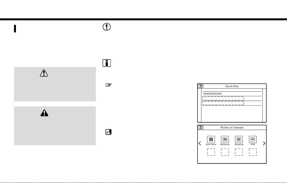
Touch [Info] on the Launch Bar and touch
[Zero Emission] to display the menu
screen where several useful functions for
electric vehicle driving can be set. Select a
preferred menu and touch an item to be
set.
“Zero Emission menu screen”
(page 2-2)
1-8
Page 33

1. Getting started
DISPLAYING CLIMATE CONTROL &
AUDIO SCREEN
1. Touch [Info] on the Launch Bar.
2. Touch [Climate Control & Audio] to
display the climate control information
and audio information.
TOUCH PANEL OPERATION
The system can be controlled mainly by
the touch panel operation.
. Touch
Select a key on the screen to select the
item and to display the corresponding
screen.
INFO:
Some keys function differently depending
on whether the key is touched briefly or
when it is being touched and held for a
few seconds.
. Swipe/Flick
Menu screen pages will skip to the
next page when swiped/flicked horizontally.
Some of the list screens can also be
scrolled by swiping/flicking on the
screen vertically.
1-9
Page 34

1. Getting started
MAIN SCREEN OPERATIONS
. Displaying previous screen
Touch [ ] to return to the screen
displayed previously.
. Horizontal scrolling
Touch [<] to scroll to the previous
page.
Touch [>] to scroll to the next page.
Indicates the position of the currently
displayed page.
. Vertical scrolling
Touch [ ]or[ ] to scroll the
message or list one item at a time.
Touch [
page.
Indicates the total number of items in
the list and the entry number of the
selected item.
]or[ ] to skip to the next
. Scrolling list by selecting alphabet
Touch one of the alphabetical keys to
scroll the list to the section of the list
that begins with the letter selected.
INFO:
Depending on the screens, swiping on the
touch screen can scroll pages vertically or
horizontally.
1-10
Page 35

1. Getting started
ADJUSTING SETTINGS
Touch adjustment keys, such as [-]/[+],
etc., to adjust each item. Each time a key is
touched, the indicator moves along the
bar.
For items with [ON] indicator, touch the
menu item to turn on/off the setting. The
indicator light will turn on when the
setting is turned on.
HOW TO INPUT LETTERS AND
NUMBERS
Basic operations to enter letters and
numbers are explained here.
Character and number input screens vary
depending on the conditions.
Alphabet input screen
Entered characters are displayed.
Touch to delete the last character
entered.
Touch and hold to delete all the
characters entered.
Touch to change the type of key-
board.
[A-Z]: Displays alphabet input screen.
]: Displays symbol input screen.
[
[123]: Displays number input screen.
Touch to switch between the upper-
case and lowercase character input
screen.
Touch to enter a space.
Touch to enter a character.
Touch to confirm the entry.
Number input screen
Entered characters are displayed.
Touch to delete the last number
entered.
Touch and hold to delete all the
characters entered.
Touch to enter a number.
Touch to confirm the entry.
1-11
Page 36

1. Getting started
HOW TO VIEW AND OPERATE
HOME MENU SCREEN
Push <MENU> or touch [MENU] on the
Launch Bar to display the HOME MENU
screen.
On the HOME MENU screen which consists
of 3 pages, preferred Shortcuts and Widgets can be laid out.
Shortcut icons
Icons for frequently used menu items
can be placed on the HOME MENU
screens as Shortcuts. Shortcuts of
navigation, information, phone, audio
and setting menus are available.
Widget
Useful information such as audio,
weather, clock, etc. can be displayed
as Widgets. Depending on the con-
tents, keys in the box can be touched
for operations.
INFO:
The HOME MENU screen can be edited.
“Customizing HOME MENU screen”
(page 1-13)
Default menus:
The following Shortcuts and Widgets are
set to be displayed as default on the
HOME MENU screen.
1-12
Shortcuts/Widgets Content
[Smartphone Connection]
[Apple CarPlay]*1
(if so equipped)
[Android Auto]*2 Page 6-12
[Charging Station] Page 3-19
[Climate Control &
Audio]
[Energy Usage] Page 2-8
[SXM Traffic] Page 6-2
[SXM Weather] Page 6-2
[SXM Movie Listings] Page 6-2
[SXM Sports] Page 6-2
[SXM Stocks] Page 6-2
[Call History] Page 7-4
[Home] Page 3-23
[Edit Menu] Page 1-13
[Previous Destina-
tions]
[Audio Information] Audio Information
[Digital Clock] Digital clock is dis-
Displayed when
neither iPhone® nor
Android phone is
connected.
Page 6-9
Page 1-9
Page 3-24
is displayed.
played.
Page 37

1. Getting started
*1: Displayed when iPhone® is connected.
*2: Displayed when Android phone is
connected.
INFO:
. Default menus on the HOME MENU
screen are subject to change without
notice.
. A SiriusXM Travel Link or SiriusXM
Traffic subscription is necessary to
receive SXM information services.
Customizing HOME MENU screen
The HOME MENU screen can be personalized by selecting which Shortcuts and
Widgets to be displayed and where to
place them on the screen.
1. Push and hold <MENU> or touch and
hold [MENU] while the HOME MENU
screen is displayed.
2. Edit the Shortcuts and the Widgets on
the Edit Home Menu screen.
3. Touch [Save] to apply the change.
Following editing operations are available.
Moving an item:
1. Touch a Widget or a Shortcut icon you
wish to move. The arrows [ < ], [ > ], [
] will appear by the icon. (Only [ <
or [
] and [ > ] are available for the Widget.)
2. Touch the arrows to move the icon.
Adding an item:
1. Touch a blank box for Widget/Shortcut.
2. Touch [ + ] displayed by the box.
3. Touch [Shortcut Icons] or [Widgets]
and select a preferred item you wish
to add.
. Available Shortcut categories
— [Audio Source]
— [Phone]
— [Info]
— [Navigation]
— [Settings]
. Available Widgets
— [Audio Information]
— [Current Conditions]
— [5-Day Weather Forecast]
— [Digital Clock]
— [Analog Clock]
]
INFO:
To add a Widget, 4 open Shortcut spots
are needed.
Deleting an item:
Touch [ X ] on the Shortcut or Widget you
wish to delete. Touch [Delete] to confirm.
Setting layout to default:
Touch [Reset] on the Edit Home Menu
screen. Touch [Yes] to confirm.
INFO:
. Touching [Settings] on the Launch Bar
and touching [Edit Home Menu] will
also display the Edit Home Menu
screen.
. Access to the SiriusXM Travel Link
services requires a SiriusXM subscription.
“SiriusXM Travel Link” (page 6-7)
1-13
Page 38

1. Getting started
. Available Shortcuts/Widgets and the
default menus on the HOME MENU
screen are subject to change without
notice.
FUNCTIONS DISABLED WHILE DRIVING
Example
1-14
Page 39

To ensure safe driving, some functions
cannot be operated or have limited operation while the vehicle driving speed is 5
MPH (8 km/h) or above.
The on-screen text and keys for these
restricted functions will be “grayed-out” or
muted and cannot be selected while
driving. In some cases, a screen message
will appear indicating a restricted function.
Restricted functions while driving include:
. Character (letter and number) input
screen.
. Scrolling and viewing of certain list
screens
. Displaying detail information and
touching item on some information
screen
. Adding/editing home location, ad-
dress book entries and current route
. Registering cellular phones
. Connecting Bluetooth® devices for the
first time
. Making a call by dial number and
handset phonebook
. Setting phone, NissanConnect® EV
and Services, Bluetooth® functions,
etc.
. Various other settings
These functions will become available
again when the vehicle speed is reduced
to below 5 MPH (8 km/h).
Some of the destination setting functions
that become unavailable while driving can
be operated by voice recognition system.
Available voice commands may differ
depending on the language setting.
1. Getting started
SYSTEM SETTINGS
The system settings can be changed for
convenience.
SETTING MENU
Touch [Settings] on the Launch Bar and
touch a setting item you wish to adjust.
1-15
Page 40

1. Getting started
Available setting items
Setting item Result
[Bluetooth] Displays the Blue-
tooth® Audio and
Phone setting screen.
“Bluetooth® settings” (page 1-18)
[Phone] Displays the Phone &
Mail setting screen.
“Phone and text
message assistant settings”
(page 7-10)
[Navigation] Displays the naviga-
tion settings screen.
“Navigation settings”
(page 3-60)
[Sound] Displays the audio
settings screen.
“Audio settings”
(page 4-26)
[Display] Displays the display
settings screen.
“Display settings”
(page 1-16)
[Volume & Beeps] Displays the volume
adjustment screen.
“Volume and
Beeps settings”
(page 1-17)
[Clock] Displays the clock ad-
[Edit Home Menu] Displays the menu
[NissanConnect
EV & Services]
[Voice Recognition]
[Camera]
(if so equipped)
justment screen.
“Clock settings”
(page 1-17)
editing screen.
“Customizing
HOME MENU
screen”
(page 1-13)
Displays the NissanConnect® EV and Services settings screen.
“NissanConnect®
EV and Services
settings”
(page 5-17)
Displays the voice recognition system settings screen.
“Voice recognition settings”
(page 8-19)
Displays the Camera
setting screen.
See LEAF Owner’s
Manual for details of
the monitor system.
[Language &
Units]
[Apple CarPlay
Settings]
(if so equipped)
[Android Auto Settings]
Displays the Language
and Units settings
screen.
“Language and
unit settings”
(page 1-17)
Displays the Apple
TM
CarPlay
screen.
Displays the Android
Auto
setting
“Apple CarPlay
settings”
(page 6-11)
TM
setting screen.
“Android Auto
settings”
(page 6-14)
TM
TM
DISPLAY SETTINGS
Menu items to adjust display settings are
available.
1. Touch [Settings] on the Launch Bar.
2. Touch [Display].
3. Touch a preferred adjustment item
and adjust to the preferred setting.
1-16
Page 41

1. Getting started
Available setting items
Setting item Action
[Display] Turns the screen off.
[Brightness] Adjusts the brightness of
[Contrast] Adjusts the contrast of the
[Background
Color]
Pushing and holding <
will also turn off the screen.
Push <
screen back on.
the display.
display.
Changes the background
color of the map screen.
Select the color mode from
[Day] and [Night].
Pushing <
change the background
color.
> to turn the
> will also
>
VOLUME AND BEEPS SETTINGS
The volume of various functions including
audio, phone, navigation voice guidance,
and system beeps can be adjusted.
1. Touch [Settings] on the Launch Bar.
2. Touch [Volume & Beeps].
Available setting items
Setting item Action
[Audio Volume]
[Guidance Volume]
[Ringtone] Adjusts the volume level
[Incoming
Call/Siri]/[Incoming Call]
[Outgoing Call] Adjusts the outgoing call
[NissanConnect EV/Svcs]
[Button Beeps] Turns on/off the button
[Guidance
Voice]
Adjusts the volume level
of the audio system.
Adjusts the volume level
of the guidance voice and
the voice recognition system voice responses.
of the ringtone of incoming calls.
Adjusts the volume level
of the incoming call or
Siri® (if so equipped).
volume.
Adjusts the volume level
of “text-to-speech” for
text messaging and NissanConnect® EV and Services announcements.
beep sound and alarm for
a prohibited operations.
Turns on/off the voice
guidance.
LANGUAGE AND UNIT SETTINGS
This changes the display language and
measurement unit used in the system.
1. Touch [Settings] on the Launch Bar.
2. Touch [Language & Units].
Available setting items
Setting item Action
[Select Language]
[Select Units] Selects the system unit.
Selects the system language. The language
setting is applied to the
touch screen display, voice
announcements, the voice
recognition system.
The unit setting can also
be applied to the information vehicle display.
INFO:
Do not push the power switch while
changing the language.
CLOCK SETTINGS
Clock settings of the system can be
changed.
1. Touch [Settings] on the Launch Bar.
2. Touch [Clock].
1-17
Page 42

1. Getting started
Available setting items
Setting item Action
[On-screen
Clock]
[Clock Format (24h)]
[Offset (hour)] Adjusts the offset value
[Offset (min)] Adjusts the offset value
[Daylight
Savings Time]
[Time Zone] Select an appropriate time
Sets the clock display on/
off. When this item is on,
the clock display appears.
Turns on/off the 24-hour
display mode. When turned
off, the clock is set to the
12-hour mode.
(hour).
(minutes).
Turns on/off the daylight
saving time setting.
zone from the list. When
selecting [Auto], the system
selects the time zone
automatically.
CONNECTING BLUETOOTH® DEVICE
Your vehicle is equipped with the Bluetooth® Hands-Free Phone System and
Bluetooth® audio player. If you are an
owner of a compatible Bluetooth® enabled cellular phone or Bluetooth® audio
device, you can set up the wireless connection between your cellular phone and
the in-vehicle phone module or Bluetooth® audio and in-vehicle audio module.
With Bluetooth® wireless technology, you
can make or receive a telephone call with
your cellular phone in your pocket and
listen to Bluetooth® audio.
Connecting cellular phone/audio
device
To use the Bluetooth® device with the invehicle system for the first time, the device
connection operation is required.
1. Touch [Settings] on the Launch Bar.
2. Touch [Bluetooth] and touch [Connect
Device]. A message is displayed.
3. Touch [Yes] to connect a cellular
phone. Touch [No] to connect an audio
device and operate as guided by the
system. (Operations may differ depending on the device.)
NOTE:
Some cellular phones or other devices
may cause interference or a buzzing
noise to come from the audio system
speakers. Storing the device in a different location may reduce or eliminate the
noise.
INFO:
. Up to 5 Bluetooth® devices can be
connected. If 5 devices are already
connected, one of the devices must
first be deleted before another device
can be connected.
“Bluetooth® settings” (page 1-18)
. The pairing procedure of the cellular
phone varies according to each cellular phone. See the cellular phone Owner’s Manual for the details.
. Visit www.nissanusa.com/bluetooth/
for a recommended Bluetooth®
device.
Bluetooth® settings
The Bluetooth® settings can be changed
according to the your preference.
1. Touch [Settings] on the Launch Bar.
2. Touch [Bluetooth].
1-18
Page 43

1. Getting started
3. Touch a preferred item.
Available setting items
Setting item Action
[Bluetooth] Turns the Bluetooth®
[Connect Device]
[Select BT Device]
[Edit Bluetooth
Information]
connection to the vehicle
on/off.
Bluetooth® devices can
be connected to the invehicle system.
Registered Bluetooth®
devices are shown on the
list. Select a device you
wish to use from the list.
You can also edit the
name, delete registered
devices or display information of the registered
device.
The in-vehicle system
name and the PIN code
can be changed. A device
address can also be
viewed.
INFO:
From [Edit Bluetooth Information], the
device name that appears on the screen
can be changed and be renamed from the
name set as default to the preferred name
(such as “Steve’s Car” for example).
1-19
Page 44

1. Getting started
MEMO
1-20
Page 45

2 Unique EV functions
Zero Emission menu screen ................................................. 2-2
Displaying estimated driving range and charging
station information ..................................................................... 2-3
Displaying estimated driving range ......................... 2-3
Displaying charging station icons on map ........ 2-5
Confirming charging station availability ............. 2-6
Updating charging station information ............ 2-7
Energy usage information display ................................. 2-8
Viewing energy usage information ....................... 2-8
Unique EV function settings ................................................ 2-9
Battery information ........................................................ 2-11
Page 46

2. Unique EV functions
ZERO EMISSION MENU SCREEN
Touch [Info] on the Launch Bar and touch [Zero Emission] to display the menu that
includes useful functions for electric vehicle driving.
Setting items
[Energy Usage] Energy usage information is displayed on the screen.
[Driving Range]
[Nearby Station] Charging station information for the current position area
[Update Stations] Charging station information is updated through connec-
[Zero Emission Settings] Various EV-specific settings can be adjusted from this
Action
“Energy usage information display” (page 2-8)
The estimated driving area within range, including the
current position is displayed on the map screen.
“Displaying estimated driving range” (page 2-3)
is displayed.
“Finding charging station” (page 3-19)
tion to the Nissan Data Center.
“Updating charging station information” (page 2-7)
menu.
“Unique EV function settings” (page 2-9)
2-2
Page 47

2. Unique EV functions
DISPLAYING ESTIMATED DRIVING RANGE AND CHARGING
STATION INFORMATION
The estimated driving range and charging
station information are displayed on the
map screen.
CAUTION
Charging station information may not
be detailed in all areas or reflect
current charging station locations.
For up to date information about
charging stations, such as business
hours or charging equipment, NISSAN
recommends that you directly access
the information on your own. Additionally, always check the Li-ion battery available charge and set a
reasonable driving schedule.
DISPLAYING ESTIMATED DRIVING
RANGE
The estimated driving range including the
current position or the destination is
displayed on the map screen depending
on the charging status of the vehicle. A
destination or a waypoint can be set on
this screen.
INFO:
The estimated driving range map shows
the predicted area the vehicle can reach
on the basis of the estimated driving
range that is indicated in the meter.
Driving habits, the actual road environment (hills, etc.), and traffic conditions
(traffic jams, etc.) will affect the actual
available range.
To display the estimated driving range,
touch [Driving Range] in the Zero Emission
menu.
“Zero Emission menu screen”
(page 2-2)
INFO:
Models with Li-ion battery warmer:
The estimated driving range will increase
or decrease when the air conditioner,
heater or Li-ion battery warmer is turned
on or off, or the vehicle is shifted between
D (Drive) and ECO, or when any other
accessory is turned on or off based on
driving.
2-3
Page 48

2. Unique EV functions
How to view driving range screen
The extended estimated driving
range is displayed using the possible
driving distance on the meter as a
radius.
The normal estimated driving range is
displayed based on the current charging condition.
[From Dest.]:
The estimated driving range around
the destination is displayed while
setting the route. If some waypoints
are set, the nearest waypoint from the
current vehicle position is centered on
the estimated driving range map.
[Go Here]:
Any locations that are displayed with-
in the estimated driving range can be
set as a destination or a waypoint.
Charging station icons:
: Normal charge icon
: Quick charge icon (for vehicle
equipped for quick charging)
The possible driving distance is displayed for each estimated driving
range.
INFO:
When a route is set that includes waypoints, the estimated driving range will be
displayed based on the nearest waypoint.
Setting a charging station as
destination
While the estimated driving area is displayed on the map screen, the spot where
the cross pointer is placed by moving the
map can be set for the destination.
1. Scroll the map, place the cross pointer
over the preferred location, and touch
2-4
Page 49

INFO:
. This procedure only allows you to set a
destination or waypoint on the driving
range screen. The system does not
automatically set a desired charging
station as a destination or waypoint.
When a charging station displayed on
the map is set as a destination by
moving the map, zoom in the map and
set a point as a destination as precisely as possible. If the destination is
not set precisely, the system may
provide guidance to a location that is
not a charging station.
. The driving range is displayed as a
numeric value above the destination
or waypoint that has been set. The
values displayed here are approximate
and should only be used as a guide.
. If setting a destination when the Li-ion
battery power level may be insufficient
to reach the set destination, the in-
formation for charging stations is displayed, allowing you to set a charging
station as the destination.
2. Unique EV functions
[Go Here].
2. When a message asking if you wish to
set the location as a destination, touch
[Yes].
3. The system sets the destination to the
selected location and starts calculating a route.
DISPLAYING CHARGING STATION
ICONS ON MAP
The charging station icons are displayed
on the map screen. There are two types of
icons: quick charge (for vehicle equipped
for quick charging) and normal charge.
1. Touch [
map screen is displayed.
2. Touch [Map Icons]. A list of map icon
types is displayed.
3. Touch [Charging Station]. The indicator illuminates when the item is set.
] while the current location
4. Push <MAP> to return to the current
location map screen. The charging
station icons are displayed on the
map.
: Normal charge icon
: Quick charge icon (for vehicle
equipped for quick charging)
2-5
Page 50

2. Unique EV functions
INFO:
When a charging icon on the map is
touched, a pop-up screen will appear.
. Touch [Go Here] to set the location as
a destination.
. Touch [Place Info] to display charging
station information.
Other settings
The charging station icon can be also set
by performing the following procedure.
1. Touch [Zero Emission Settings] in the
Zero Emission menu.
“Zero Emission menu screen”
(page 2-2)
2. Touch [Map icons for charging stations].
or
1. Touch [Settings] on the Launch Bar.
2. Touch [Navigation].
3. Touch [Map Icons].
INFO:
. Setting can be changed to display
normal charge station icons only or
to display both the normal charge and
quick charge station icons on the map.
To display normal charge station icons
only, turn off the setting of [QUICK
CHARGE] in [Charge Port Types to
Include in Station Searches] menu.
“Unique EV function settings”
(page 2-9)
. The map icons are not displayed on
the map screen when the map scale is
set to 1/4 mile (500 m) or higher in the
2D map and the Birdview
. Settings of the charging station icons
registered in the address book cannot
be changed with this procedure.
“Editing stored home and location” (page 3-55)
CONFIRMING CHARGING STATION
AVAILABILITY
It is possible to confirm the availability of
charging stations via the Nissan Data
Center. This allows you to reduce the time
spent waiting to charge.
2-6
TM
map.
Viewing from information menu
screen
1. Touch [Info] on the Launch Bar.
2. Touch [NissanConnect EV & Services].
3. Touch [Charging Availability].
4. Select the area for charging station
search.
. [Near Current Location]:
Displays a list of charging stations
that are near the current vehicle
location.
. [Near Destination]:
Displays a list of charging stations
that are near the destination, when
a destination has been set.
. [Near Scroll Position]:
Displays a list of charging stations
that are near the cursor when the
map has been moved.
Page 51

2. Unique EV functions
5. A list screen is displayed. Confirm the
charging station information from the
list. Full/vacant information of charging station is indicated by icon color.
Icons Charging
station type
Normal
charge icon
Quick charge
icon
Normal
charge icon
Quick charge
icon
Normal
charge icon
Quick charge
icon
Availability
Green: Fully vacant
Yellow: Partly vacant
Red: Full
Gray: No information
or unclear
Closed or out of
service
No information
INFO:
Touch [Options] to select types of charging stations you wish to include in the
searched location list.
Available items:
. [Show Along Route]:
Shows charging stations located
along the route to destination.
. [Show Quick Charging Stations Only]:
Shows charging stations with quick
charger.
. [Available Spot Only]:
Shows charging stations that are
available.
. [Free Only]:
Shows charging stations that are free
of charge.
. [Select Payment System]:
Select payment method and the
usable charging stations are displayed.
Viewing from map menu
Charging station information can also be
obtained from map menu.
1. Touch [
map screen is displayed and then
touch [Charge Avail.].
2. The system connects to Nissan Data
Center, and a list of search results will
be displayed.
] while the current location
UPDATING CHARGING STATION
INFORMATION
An active NissanConnect® EV and Services
subscription is needed to update charging station information.
Information about the charging stations
that are located around the current position, destination and your home is updated through connection to the Nissan
Data Center.
While the vehicle is connecting to the
Nissan Data Center, information related
to charging stations in the area around
your home will be automatically updated.
Also, when the driving range is restricted,
information related to charging stations
in the area near the current vehicle
location will also be automatically updated.
“Unique EV function settings”
(page 2-9)
Charging station information for the area
around a location set can be updated
manually by using the following procedure.
1. Touch [Update Stations] in the Zero
Emission menu.
“Zero Emission menu screen”
(page 2-2)
2-7
Page 52

2. Unique EV functions
2. Touch the preferred setting item. The
system then connects to the Nissan
Data Center and the update of charging station information will start.
Available settings
. [Near Current Location]:
Charging station information for
the area around the current position is updated.
. [Near Destination]:
Charging station information for
the area around the destination is
updated.
. [Near Home]:
Charging station information for
the area around your home is
updated. Registration of your home
in the Address Book is necessary
before using this item.
“Storing home location”
(page 3-52)
. [Near a location on the Map]:
Charging station information for
the area where the cross pointer is
placed by moving the map is updated.
3. When the update is completed, a
message is displayed.
INFO:
. When [Stop] is touched while updating
information, connection to the Nissan
Data Center is disconnected.
. If communication with the Nissan Data
Center is disconnected due to poor
signal reception, a message will be
displayed. Touch [Yes] to restart the
download.
2-8
ENERGY USAGE INFORMATION
DISPLAY
Energy usage information is displayed.
VIEWING ENERGY USAGE INFORMATION
Estimated driving range and energy
usage of various systems are displayed.
Touch [Energy Usage] in the Zero Emission menu.
“Zero Emission menu screen”
(page 2-2)
Driving Range:
The possible driving distance based
on the current charging status is
displayed.
Variable distance:
When the climate control system is
turned on, the additional distance the
vehicle can drive by turning the cli-
Page 53

2. Unique EV functions
mate control system off is displayed.
When the climate control system is
turned off, the distance the vehicle
can drive less if the climate control
system is turned on is displayed.
Electric Motor:
Energy usage by the motor and
regenerated energy are displayed.
Climate Control:
Energy usage by the climate control
function is displayed.
Other Systems:
Energy usage by other equipment
(headlights, windshield wiper, etc.) is
displayed.
UNIQUE EV FUNCTION SETTINGS
EV unique function settings can be changed.
An active NissanConnect® EV and Services
subscription is needed to remotely check
charge status, battery status, use remote
charging, remotely start heating and cooling and to receive e-mails/text messages.
1. Touch [Zero Emission Settings] in the
Zero Emission menu.
“Zero Emission menu screen”
(page 2-2)
2. Touch the item you wish to set.
2-9
Page 54

2. Unique EV functions
Setting items Action
[Battery Alerts] [Use All Battery Alerts] Displays all battery alerts on the navigation screen.
[Low Battery] Displays the Low Battery message on the touch screen display to
[Dest. out of Range] Displays a message on the navigation screen to inform the driver that
[Charging Messages] Sends a notification to a preset e-mail address. This notification
[Map icons for charging stations] Displays charging station icons on the map screen.
[Other Settings] [Autosave New Charging Station] If charging station information you have used is not stored in the
[Auto-Update Stations] While the vehicle is connecting to the Nissan Data Center, information
[Charge Port Types to Include in
Station Searches]
[Show Icon of Closed Charging
Station]
inform the drive that the Li-ion battery charge is low.
“Low Battery” (page 2-11)
the battery should be charged soon. This will be indicated if the
estimated driving range is less than the remaining distance to the
destination when a route to the destination is set.
“Charge recommendation guidance” (page 2-11)
includes the charge connector status and the charge completion.
“NissanConnect® EV and Services settings” (page 5-17)
“Displaying charging station icons on map” (page 2-5)
system, the location will be automatically registered in the Address
Book.
Turn this setting off if you do not want the charging location to be
stored automatically.
You can set charging stations that are automatically registered by
type. Select from [Quick], [Standard] and [Trickle].
related to charging stations near your home will be automatically
updated.
When [QUICK CHARGE] setting is turned off, the quick charge icon will
not be displayed.
When this item is turned on, the charging stations that are out of
business hours are displayed and shown as icons.
2-10
Page 55

2. Unique EV functions
INFO:
. For vehicles without the quick charge port, NISSAN recommends turning off the quick charging station icons by turning off the
[QUICK CHARGE] setting.
BATTERY INFORMATION
Information notifying the driver of the
battery status can be displayed on the
touch screen display.
For detail information about the warning/
indicator lights, see the LEAF Owner’s
Manual.
Charge recommendation guidance
If the remaining driving range is less than
the distance to the destination that is
entered while setting the route, the system displays a message on the navigation
screen that recommends battery charging.
1. The notification is displayed on the
upper left side of the screen. Touch
[Show] to display the detailed information screen.
2. The system displays a message screen
and announces the contents of the
message to recommend battery charging. Check the message displayed on
the screen.
Touch [Nearby Station] to search all
charging stations that are located
near the current vehicle position.
“Finding charging station”
(page 3-19)
3. Touch [
Launch Bar or push <MAP> to return
to the current location map screen.
], touch [Map] on the
INFO:
. The charge recommendation gui-
dance can be set to off.
“Unique EV function settings”
(page 2-9)
. When the route is changed to avoid a
traffic jam or the possible driving
distance indicated in the meter is
changed, the charge recommendation
guidance is displayed again.
Low Battery
When the Low battery charge warning
light
(yellow)
system displays a message on the touch
screen display that notices the driver that
the Li-ion battery charge is low.
and the master warning light
illuminate in the meter, the
2-11
Page 56

2. Unique EV functions
(page 3-19)
1. The notification is displayed on the
upper left side of the screen. Touch
[Show] to display the detailed information screen.
2. The system displays a message screen
and announces the contents of the
message to warn that the Li-ion battery charge is low. Check the message
displayed on the screen.
Touch [Nearby Station] to search all
charging stations that are located
near the current vehicle position.
“Finding charging station”
3. Touch [
Launch Bar or push <MAP> to return
to the current location map screen.
INFO:
. The Low Battery message display can
be turned off.
“Unique EV function settings”
(page 2-9)
. When the Li-ion battery charge is low,
the system automatically obtains
charging station information.
], touch [Map] on the
2-12
Page 57

3 Navigation
Safety information ....................................................................... 3-3
Map operation ................................................................................. 3-3
Displaying current vehicle location .......................... 3-3
Map types ..................................................................................... 3-3
Road color ................................................................................... 3-6
Map symbols .............................................................................. 3-7
Moving map ................................................................................ 3-8
Changing scale of map ..................................................... 3-9
Changing map ....................................................................... 3-10
Map view settings ............................................................... 3-11
Setting information on map ....................................... 3-14
Traffic information on map ......................................... 3-15
Map Menu screen ............................................................... 3-15
Setting destination ................................................................... 3-16
Basic operations .................................................................. 3-16
Finding address .................................................................... 3-19
Finding charging station ............................................... 3-19
Finding nearby place ........................................................ 3-21
Finding points of interest ............................................. 3-21
Setting home as destination ..................................... 3-23
Searching from address book .................................. 3-24
Searching from previous destinations ............... 3-24
Setting intersection ........................................................... 3-25
Setting by phone number ............................................ 3-25
Setting city center .............................................................. 3-26
Setting freeway entrance/exit .................................. 3-26
Setting from stored routes ......................................... 3-26
Setting using Google Maps ....................................... 3-27
Setting destinations by Google ............................. 3-27
Setting using Route Planner .................................... 3-28
Setting point on map .................................................... 3-28
Setting with NissanConnect® EV
and Services ......................................................................... 3-28
Searching by using Voice Menu button
on map ..................................................................................... 3-29
Options before starting the
route guidance ................................................................... 3-29
Route guidance .......................................................................... 3-31
About route guidance ................................................... 3-31
Route menu .......................................................................... 3-37
Setting new destination .............................................. 3-40
Canceling Route ................................................................ 3-40
Confirming route .............................................................. 3-40
Editing route ......................................................................... 3-40
Recalculating route ......................................................... 3-43
Searching for detour route using
traffic information ............................................................ 3-43
Setting detour route ...................................................... 3-44
Route guidance settings ............................................. 3-44
Viewing traffic information ............................................... 3-49
Viewing available traffic information ................ 3-49
Traffic information setting ........................................ 3-51
Storing a location/route ..................................................... 3-52
Storing location ................................................................. 3-52
Storing route ........................................................................ 3-53
Page 58

Storing avoid area ............................................................... 3-53
Editing stored information .......................................... 3-54
Deleting stored item ......................................................... 3-57
Transferring information to/from
address book ....................................................................... 3-58
Navigation settings ................................................................. 3-60
Page 59

3. Navigation
SAFETY INFORMATION
The navigation system is primarily designed to help you reach your destination.
However, you, the driver, must use the
system safely and properly. Information
concerning road conditions, traffic signs
and the availability of services may not
always be up to date. The system is not a
substitute for safe, proper, and legal driving.
WARNING
. Do not rely on route guidance
alone. Always be sure that all
driving maneuvers are legal and
safe in order to avoid accidents.
MAP OPERATION
DISPLAYING CURRENT VEHICLE
LOCATION
Push <MAP> or touch [Map] on the
Launch Bar to display the map of current
vehicle location.
MAP TYPES
Two types of map views are available: 2D
map and Birdview™ (3D) map.
3-3
Page 60

3. Navigation
2D map
The 2D map displays the map in a two-dimensional environment similar to a road map.
Screen information:
Destination:
Indicates the location of the final
destination.
Waypoint:
Displays the location of the waypoint
the vehicle will stop by before heading
to the final destination. A maximum of
5 waypoints can be set.
Guide point:
Indicates a guide point on the route.
Starting point:
Displays the vehicle location, with
which the route is set, as the starting
point.
Avoid area:
Displays the areas to avoid that are
stored in the Address Book. Route
guidance can be set to avoid the
3-4
registered avoid areas.
“Storing avoid area” (page 3-53)
Green: Freeways included
Blue: Freeways not included
Speed limit icon:
Displays the speed limit of the road
the vehicle is on.
Arrow and distance:
Indicates the distance to the next
guide point and the turning direction
at that guide point.
icon:
Touch the icon to display the Map
Menu.
“Map Menu screen” (page 3-15)
Scale indicator:
Indicates the scale of the map.
Touch the icon to display the scale
bar. The map scale can be adjusted
using the scale bar.
“Changing scale of map”
(page 3-9)
/ Direction indicator:
Indicates the directional setting of the
map.
: North always pointing up.
: Direction of the vehicle heading
Page 61

3. Navigation
always pointing up.
Touch the icon to change the map
view and the map orientation.
“Changing map view and map
orientation” (page 3-10)
Remaining distance to the destination:
Indicates the approximate remaining
distance to the destination or waypoint. This indicator will appear when
a destination or waypoint is set and
route guidance is started.
The arrow displayed here indicates
the direction of the destination. It can
be displayed only when the map scale
is in the range of 1/64 miles (25 m) 1/8 miles (200 m).
Estimated time to the destination:
Indicates the estimated time to the
destination or waypoint. This indicator will appear when a destination or
waypoint is set and route guidance is
started.
“Guidance settings” (page 3-45)
Traffic indicator:
Indicates the reception condition of
the traffic information transmitted
from the provider.
Green: Reception condition is good.
Gray: Reception condition is not good.
The indicator does not appear with-
out a SiriusXM Traffic subscription.
Vehicle icon:
Indicates the current vehicle location
and the direction the vehicle is heading.
Suggested route:
Appears in bold blue during route
guidance.
Stored location (yellow):
Displays the locations that are stored
in the Address Book.
“Storing location” (page 3-52)
The icons can be changed according
to your preferences.
Street name:
Displays the name of the street that
the vehicle is currently driving on.
Voice Menu button:
Touch the icon to connect to the
NissanConnect® EV and Services
Voice Menu.
“Connecting to Interactive Voice
Menu” (page 5-12)
Birdview™ (3D) map
Birdview™ displays the map from an
elevated perspective. In Birdview™, it is
easy to recognize an image of the route
because it provides a panoramic view
over a long distance.
INFO:
Note the following items about the Birdview™ display.
. “Birdview™” is a registered trademark
of Clarion Co., Ltd.
. The map in Birdview™ always appears
with the current forward direction
facing up.
3-5
Page 62

3. Navigation
Building graphics
In an area where the building graphics are
stored in the map data, the building
graphics are displayed when the map is
zoomed in. On the 2D map display, these
are called “Building footprint graphics”,
and on the Birdview™ display, these are
called “3D building graphics”.
Building footprint graphics (2D map)
3D building graphics (Birdview™ map)
INFO:
In an area where the building graphics are
not stored in the map data, the normal
map is displayed even when the map is
zoomed in.
ROAD COLOR
The road types are differentiated by color.
Red Freeway
Brown
Dark Yellow
Gray Narrow street
Dark green Road with incomplete
Main road
map data
3-6
Page 63

MAP SYMBOLS
This navigation system uses symbols to display facilities.
2-dimensional icons (Plan View)
3. Navigation
3-7
Page 64

3. Navigation
Charging station icons:
Charging station locations are displayed
with icons below on the map.
: Normal charge icon
Quick charge icon (for vehicle
:
equipped for quick charging)
INFO:
. The charging station icons are not
displayed on the map screen when
the map scale is set to 1/4 mile (500 m)
or wider.
. Charging station icon display can be
turned on/off.
“Displaying charging station icons
on map” (page 2-5)
When the map scale is set between 1/32
miles (50 m) and 1/16 miles (100 m), icons
below can be displayed.
. When charging station information is
updated, the updated charging stations will be displayed as icons with
“New” marked by the charging station
icon.
Updated normal charge
station
Updated quick charge
station
. Charging stations that are registered
as open 24 hours are displayed in
icons with “24” marked by the charging
station icon.
24 hours open normal
charge station
24 hours open quick
charge station
INFO:
The “New” and “24” indicators are not
available when the map scale is in 1/8
miles (200 m) level or wider.
MOVING MAP
Map can be scrolled by touch screen
operations. Map scrolling operations are
limited and not fully available while driving.
Touch:
2D map:
When the map on the screen is touched,
the cross pointer is displayed and the
position touched is set as the center of
the screen.
After moving the map, touch [
map screen to display the current location
map screen.
INFO:
Touch [Slow] on the map screen to display
the 8-directional key for fine adjustments
of the location. Touch [Cancel] to cancel
the fine adjustment mode.
Birdview
Touch the screen. The cross pointer is
displayed at the center of the map.
Touching the screen again will scroll the
map toward the touched location.
TM
(3D) map:
] on the
3-8
Page 65

3. Navigation
Touch [ ]or[ ] to change the direction
of the map.
Long touch:
Touch the direction to move to. The map
continues to scroll while the screen is
touched.
Drag:
Drags the map while the screen is
touched.
Swipe/flick:
Swipe or flick the screen to scroll the map
screen quickly.
CHANGING SCALE OF MAP
1. Touch [ ].
The scale bar is displayed.
2. Touch [ZOOM IN] or [ZOOM OUT] to
change the scale.
Pinch-in
To view a wider area, pinch-in the map
screen.
Pinch-out
To view the map in detail, pinch-out the
map screen.
INFO:
While driving, pinch-in and pinch-out operations are disabled.
Map scale
Map scale (map coverage) between 320
miles (640 km) and 1/64 mile (25 m) can be
selected.
US Units Metric Units
320 mi 640 km
80 mi 160 km
32 mi 64 km
8mi 16km
5mi 10km
2mi 4km
1mi 2km
1/2 mi 1 km
1/4 mi 500 m
1/8 mi 200 m
1/16 mi 100 m
1/32 mi 50 m
1/64 mi 25 m
3-9
Page 66

3. Navigation
INFO:
Depending on the map scale, traffic information icons cannot be displayed on
the map screen.
“Traffic information on map”
(page 3-50)
CHANGING MAP
Changing map view and map
orientation
The map view and the map orientation
can be changed by touching [
the map screen.
The screen will change to North Up,
Heading Up and Birdview
[
]/[ ] is touched.
North Up
TM
each time
]/[ ]on
Heading Up
Birdview™
INFO:
. You can also change the map view
from the map view settings screen.
“Map view settings” (page 3-11)
. A long range map is available that
displays a wider area in the direction
the vehicle is moving in the Heading
Up view.
“Map view settings” (page 3-11)
Setting split screen
Two different maps can be displayed on a
screen with the split screen setting.
1. Touch [ ] on the map screen.
2. Touch [Map View].
3. Touch [Change View].
4. Select [Split: 2D Map] or [Split: Birdview
Map].
INFO:
The settings on the left split map can be
changed from map view settings menu.
“Map view settings” (page 3-11)
3-10
Page 67

3. Navigation
MAP VIEW SETTINGS
The setup for the map view is performed
from the Settings menu on the touch
screen display.
1. Touch [
2. Touch [Map View].
INFO:
[Map View] can also be accessed from
[Settings] on the Launch Bar.
“Navigation settings” (page 3-60)
The following settings are available.
Menu item Action
[Change View] [2D Map] Display 2D map.
[View Settings] [Intersection] Display the enlarged view of intersection on the left side of the
[Map Settings] [Map Orientation] [North Up] Select a map view to be applied to the map screen. [Map
] on the map screen.
[Split: 2D Map] Display 2D map on both left and right side of the split screen.
[Birdview (3D)] Display 3D map.
[Split: Birdview Map] Display 2D map on the left side and 3D map on the right side of the
screen.
screen during route guidance.
“Route guidance screens” (page 3-35)
[Turn List] Display the turn list on the left screen when a route is set.
“Route guidance screens” (page 3-35)
[Full Map] Display full map screen.
Orientation] is available only when 2D map is displayed.
[Heading Up]
3-11
Page 68

Menu item Action
[Long Range] The position of the vehicle icon can be changed to view a wider
area in the traveling direction. The vehicle icon is located slightly
lower than the center of the screen. Long Range Map View is
available only when the map view is “Heading Up”.
[Map Color] Sets map color from color 1 - 4.
[Map Text Size] [Large] Sets the font size of text displayed on the map screen.
[Medium]
[Small]
[Birdview Angle] Adjusts the Birdview™ angle using the adjust bar displayed on the
left side of the screen. [Birdview Angle] is available only when 3D
map is displayed.
[North Up when Zoomed Out] When this setting is ON, the orientation of the map is automatically
changed to North Up when the widest map scale is selected.
[Select Text to Display
on Map]
[Place Names] Allows place names to be displayed on the map screen.
[Facility Names] Allows facilities names to be displayed on the map screen.
[Road Names] Allows road names to be displayed on the map screen.
[Left Split Map Settings]
[Map Orientation] The map orientation for the left side of split screen can be selected
from North Up or Heading Up.
[Long Range] Long Range Map View is available only when the left side of split
screen is in Heading Up mode.
With this item turned on, the vehicle position icon on the left
screen will be located slightly lower than the center of the screen
so that a wider area in the traveling direction can be viewed.
[Map Scale] Allows to change the scale of the map displayed on the left side of
the split screen.
3. Navigation
3-12
Page 69

Menu item Action
[Show all Freeway Exits on Route] Turns on/off the freeway exit information display.
[Auto. Show Turn List on Freeway] The turn list can be set to on or off to be displayed automatically
while driving on a freeway.
[Back to Map] Back to the current location map.
3. Navigation
3-13
Page 70

3. Navigation
SETTING INFORMATION ON MAP
Some information on the map can be
displayed or hidden.
Displaying map icons
Displays map icons of certain points of
interest (such as restaurants and charging stations, etc.) on the map around the
current vehicle location.
1. Touch [Settings] on the Launch Bar.
2. Touch [Navigation].
3. Touch [Map Icons].
4. Touch the preferred icon. The indicator of the selected icon illuminates.
Available setting icons
: Restaurant
.
.
/ : Charging Station
.
: Hotel
: ATM
.
: Rest Area
.
INFO:
. [Map Icons] can also be accessed from
[
] on the Map screen.
. The map icons are not displayed on
the map screen when the map scale is
set to 1/4 mile (500 m) or wider in the
2D and Birdview™ map.
. If brand icons are registered in the
map data, the brand will be displayed
on the map instead of the general map
icons listed.
Displaying map scrolling information
Information about the location, on which
the center of the cross pointer is placed by
scrolling on the map, can be set to be
displayed.
1. Touch [Settings] on the Launch Bar.
2. Touch [Navigation] and touch [Others].
3. Touch [Map Scrolling Information].
4. Touch the preferred information item.
The following information items are
available.
3-14
. [Address Book Icons]
. [Destination/Waypoint Icons]
. [Show pop-up for POIs]
. [Latitude/Longitude Info]
INFO:
. When the settings are turned on,
placing the cross pointer on the stored
location icons, Destination/Waypoint
icons or map icons will display the
information in a pop-up window. The
latitude/longitude of any point on the
map where the cross pointer is located
will be displayed on the bottom left
corner of the map screen.
. When the [Go Here] is displayed on the
pop-up window, destination can be
set by touching it. Touch [Place Info] to
display the place information screen.
On the place information screen,
touch [Show Map] to display the map
around the location and touch [Call] to
call the selected place if the key is
available. When available, touch [Details] to show detail information of the
place.
Page 71

3. Navigation
TRAFFIC INFORMATION ON MAP
With a subscription to SiriusXM Traffic,
traffic information is displayed.
“Traffic information on map”
(page 3-50)
Free Flow: Green arrow
Moderate traffic: Yellow arrow
Heavy traffic: Red
Section affected by serious traffic event:
Purple
The following traffic information icons
may be displayed.
: Accident
: Closed road
: Information
: Road work
: Slippery road
: Weather
: Incident
INFO:
Traffic icons are displayed in the scale
level of 1/64 miles (25 m) - 5 miles (10 km)
range. Some traffic icons are displayed
only on the map at higher detail levels.
MAP MENU SCREEN
Touch [ ] while the current location
map screen or a scrolled map screen is
displayed to display the menu corresponding to that screen.
This menu can be used to quickly access
helpful functions, such as setting a destination and searching for points of interest
nearby.
Current location map menu
screen
If [ ] is touched while the current
location map screen is displayed, the
following options are available.
. [Save Location]:
Stores the current vehicle location in
the Address Book.
“Storing location by moving map”
(page 3-53)
. [Nearby POIs]:
Searches for Points Of Interest near
the current vehicle location.
“Finding nearby place” (page 3-21)
. [Map View]:
Map view settings can be changed.
“Map view settings” (page 3-11)
. [Map Icons]:
The map icons can be displayed or
hidden by type.
“Displaying map icons” (page 3-14)
. [Update Stations]:
Connect to the Nissan Data Center to
update charging station around the
current vehicle location.
“Updating charging station information” (page 2-7)
. [Charge Avail.]:
Allows the driver to obtain the availability information of charging stations via Nissan Data Center.
“Confirming charging station
availability” (page 2-6)
3-15
Page 72

3. Navigation
Scrolled location map screen
If [ ] is touched while a scrolled map
screen is displayed, the following options
are available.
. [New Destination]:
Sets the map location pointed at by
the cross pointer as a new destination.
“Setting point on map”
(page 3-28)
. [Add to Route]:
Adds the map location pointed at by
the cross pointer as a destination or a
waypoint to the route already set.
“Setting destination or waypoint”
(page 3-41)
. [Nearby POIs]:
Searches for Points Of Interest near
the map location.
“Finding nearby place” (page 3-21)
. [Save Location]:
Stores the map location pointed at by
the cross pointer in the Address Book.
“Storing location by moving map”
(page 3-53)
. [Update Stations]:
Connect to the Nissan Data Center to
update charging station around the
point of the cursor.
“Updating charging station information” (page 2-7)
. [Charge Avail.]:
Allows the driver to obtain the availability information of charging stations via Nissan Data Center.
“Confirming charging station
availability” (page 2-6)
SETTING DESTINATION
The destination you wish to drive to can
be set for route guidance.
BASIC OPERATIONS
Displaying destination setting
menu
There are several methods that can be
used to set a destination. Select a preferred method for finding and setting a
destination.
Touch [Navi] on the Launch Bar.
The destination screen will be displayed
when a route is not set.
INFO:
If a route is set, the route menu screen will
be displayed when [Navi] on the Launch
Bar is touched. Touch [New Destination]
to set a destination.
“Route menu” (page 3-37)
3-16
Page 73

3. Navigation
Available destination setting methods:
Setting item Action
[Street Address] Searches for a destination by address.
[Charging Station] Searches for charging stations located near the current vehicle location, destination, pointed
[Nearby Points of Interest] Searches for points of interest near the current vehicle location, such as restaurants and
[Points of Interest] Searches for a destination from various categories of businesses or locations.
[Home] Searches for a route from the current location to the previously stored home location.
[Destinations by Google
[Address Book] Searches for a destination from Address Book.
[Previous Destinations] Searches for the destination from the previous destinations and a previous start point.
[Intersection] Sets an intersection as a destination.
[Phone Number] Searches for a point of interest by a telephone number.
[City Center] Sets the center of a city as the destination.
[Freeway Entrance/Exit] Sets a freeway entrance/exit as a destination.
TM
] Sets a place searched by Google as a destination.
“Finding address” (page 3-19)
place on map and city center. Nearby station availability can also be checked from this menu.
“Finding charging station” (page 3-19)
charging stations, etc.
“Finding nearby place” (page 3-21)
“Finding points of interest” (page 3-21)
“Setting home as destination” (page 3-23)
“Setting destinations by Google” (page 3-27)
“Searching from address book” (page 3-24)
“Searching from previous destinations” (page 3-24)
“Setting intersection” (page 3-25)
“Setting by phone number” (page 3-25)
“Setting city center” (page 3-26)
“Setting freeway entrance/exit” (page 3-26)
3-17
Page 74

3. Navigation
[Stored Routes] Sets a route from the stored route data.
[Send to Car] Searches for a destination using Google Maps.
[Route Planner] Sets a route plan downloaded from the NissanConnect® Website.
INFO:
. If the required battery power level may
be insufficient when the destination is
set, the system provides guidance to
any available charging stations.
. If setting a destination when the Li-ion
battery power level may be insufficient
to reach the set destination, the information for charging stations is displayed, allowing you to set a charging
station as the destination.
. After setting a destination, the location
of the destination can be adjusted and
the location can be stored in the
Address Book, etc.
“Options before starting the route
guidance” (page 3-29)
. The destination can be deleted.
“Canceling Route” (page 3-40)
“Setting from stored routes” (page 3-26)
“Setting using Google Maps” (page 3-27)
“Setting using Route Planner” (page 3-28)
Specifying region
With some destination setting methods,
state/province and city can be specified
prior to searching for destination locations.
1. Touch [Navi] on the Launch Bar.
2. Touch the desired search method.
3. Touch [State/Province] or [City] if displayed.
4. Enter the name of the state, province
or city and then touch [List]. A list
screen is displayed.
5. Touch the preferred state, province or
city from the list.
INFO:
. When the system is restarted, the state
and province in which the vehicle is
recognized by the GPS to be located
will be set automatically as a state and
province for location search.
. Touch [Change Area] to change the
area for conducting the location
search.
. Touch [Current State] to search for the
destination within the state or province where the vehicle is currently
located.
. Touch [Space] to enter a space be-
tween letters.
. After touching [City], touching [Last 5
Cities] can display the last 5 cities set
as destinations.
3-18
Page 75

3. Navigation
. In some cases, when a city name has
been entered, the number of matching
destinations in the “Matches” column
may be different from the number
displayed on the list screen. If this
occurs, enter more characters to
further reduce the number of
matches.
. It is not possible to search for a route
from the continental United States or
Canada to Hawaii, Virgin Islands, Puerto Rico, etc.
FINDING ADDRESS
Searches for a destination by address.
1. Touch [Navi] on the Launch Bar.
2. Touch [Street Address]. The street
address input screen is displayed.
3. Input the street address.
. Touch [State/Province] to enter the
state or province name.
. Touch [House #] to enter the house
number. If the house number is not
available, touch [No House #].
. Touch [Street] to enter the street
name. After finishing the entry,
touch [List]. A list of streets is
displayed.
. Touch [City] to enter the city name.
If the city name is not available,
touch [All Cities].
4. Enter the state/province, house number, street and city of the destination
and then touch [OK]. The route is
displayed.
5. Touch [Start] to start route guidance.
Voice command
1. Push <
> located on the steering
wheel.
2. After the tone sounds, speak a command.
Use the following voice command to
search for a destination by address:
“Street Address”*
*: This voice command operation is avail-
able only when the language setting is in
English.
FINDING CHARGING STATION
Searches for charging stations.
1. Touch [Navi] on the Launch Bar.
2. Touch [Charging Station]. A list of
search conditions is displayed.
Search conditions:
. [Near Current Location]
Displays a list of charging stations
that are near the current vehicle
location.
. [Near Destination]
Displays a list of charging stations
that are near the destination, when
a destination has been set.
. [Near Scroll Position]
Displays a list of charging stations
near location where the cross pointer is located on the map.
. [Near City Center]
Displays a list of charging stations
when a city name is entered.
. [Near Another POI]
Displays a list of facilities equipped
with charging station when POI is
selected.
3-19
Page 76

3. Navigation
. [Nearby Charging Availability]
Displays a list of nearby charging
stations and icons that show their
current availability by connecting to
Nissan Data Center.
“Confirming charging station
availability” (page 2-6)
3. Select preferred searching conditions.
4. Select a charging station from the list.
INFO:
. Touch [Options] to select from the
following options. Available items
may vary depending on certain
conditions.
— [Show Along Route]:
Shows charging stations located
along the route to destination.
— [Show Quick Charging Stations
Only]:
Shows charging stations with quick
charger.
— [Available Spot Only]:
Shows charging stations that are
available.
— [Free Only]:
Shows charging stations that are
free of charge.
— [Select Payment System]
Select payment method and the
usable charging stations are displayed.
. Touch [ ]or[ ] on the list to view
charging station information. On
the place information screen, touch
[Show Map] to display the map
around the location and touch [Call]
to call the selected place if the key is
available. When available, touch [Details] to show detail information of
the place.
5. Touch [Yes] to confirm the message
displayed on the screen.
6. Touch [Start] to start the route guidance.
NOTE:
Equipment that is displayed on the
charging station information screen is
not necessarily compatible with a LEAF.
Be sure to check whether equipment
can be used with a LEAF beforehand.
INFO:
Charging station search menus can also
be accessed with the following procedure.
. Touch [Nearby Station] in the Zero
Emission menu.
“Zero Emission menu screen”
(page 2-2)
Voice command
1. Push <
wheel.
2. After the tone sounds, speak a command.
Use the following voice command to
search for a destination by address:
“Charging Station”
> located on the steering
3-20
Page 77

3. Navigation
FINDING NEARBY PLACE
A facility located near the current vehicle
location can be set as the destination.
1. Touch [Navi] on the Launch Bar.
2. Touch [Nearby Points of Interest]. The
category list is displayed.
3. Select [Emergency Services] for example.
4. Select preferred category from the sub
category list.
5. Touch the preferred destination from
the list. The position of the selected
location is displayed in the preview on
the touch screen display.
INFO:
. If the suggested route is already set,
by touching [Show Along Route] on
the touch screen display, the system displays only the facilities located along the route.
. A maximum of 100 facilities can be
displayed on the list screen.
6. Touch [Start] to start route guidance.
INFO:
. Depending on the type of facility, a
message asking if you have checked
the facility availability may be displayed. Touch [Yes] or [No] after reading the message.
. You can also set the destination by
touching [
and selecting [Nearby POIs] from the
menu.
. Nearby Points of Interest category list
can be customized from [Customize
Nearby POIs].
] when scrolling the map
“Navigation settings” (page 3-60)
Voice command
1. Push <
wheel.
2. After the tone sounds, speak a command.
Use the following voice command to set a
nearby place as a destination:
“Nearby”
> located on the steering
FINDING POINTS OF INTEREST
This allows you to find a facility by name
or by category. Specify the region and city
of the destination to find it more quickly.
NOTE:
Locations and business hours of facilities are subject to change, which may
not be reflected in the map data. Double-check this information before you
go to an emergency facility to ensure
that you can receive the proper support.
Otherwise, you may not receive emergency help when you arrive at the
destination.
A confirmation message also appears
on the navigation screen. Follow the
displayed instructions and check the
items required.
3-21
Page 78

3. Navigation
Searching for a specific name
1. Touch [Navi] on the Launch Bar.
2. Touch [Points of Interest].
3. Touch [Spell Name]. A character input
screen is displayed.
INFO:
Touch [City] and touch [Last 5 Cities] to
display the last 5 cities recently set as
destinations.
4. Enter the name of the destination
facility. After finishing the entry, touch
[List]. A list screen is displayed.
5. Touch the preferred destination facility from the list.
Sorting and filtering:
. [By Distance]:
Shows a list of facilities that are
near the current vehicle location.
. [New Category]:
Displays the list that summarizes
the listed names into categories.
Select the category to narrow down
the search.
INFO:
. Touch [ i ] on the list screen to
display the detailed information
about the POI that is selected on
the touch screen display.
. To search for a POI with two or more
words, touch [Space] to enter a
space between each word.
6. A map of the selected place is displayed. Touch [Start] to start route
guidance.
INFO:
. After setting a destination, the location
of the destination can be adjusted and
the location can be stored in the
Stored Location, etc.
“Options before starting the route
guidance” (page 3-29)
Voice command
1. Push <
wheel.
2. After the tone sounds, speak a command.
Use the following voice command to
search for Points of Interest from a facility
name:
“Points of Interest <POI Name>”*
*: This voice command operation is avail-
able only when the language setting is set
to English.
> located on the steering
Searching Points of Interest by
category
1. Touch [Navi] on the Launch Bar.
2. Touch [Points of Interest]. The main
category menu is displayed.
3. Touch the main category. The subcategory list is displayed.
4. Touch the subcategory. Narrow down
condition screen is displayed.
5. Touch the narrow down category.
Search conditions:
. [Sorted By Name]:
Enter the name of the facility
3-22
Page 79

3. Navigation
. [Select a City]:
Input the city to narrow down the
target city.
. [Near Current Location]:
Facilities near the current vehicle
location are displayed in a list.
. [Near Destination]:
When the destination is set, this
indicates a list of facilities around
the destination.
6. Touch the preferred destination facility from the list.
Touch [Start] to start route guidance.
INFO:
. Subcategories may not be displayed
depending on the selected main category.
. If there is no nearby POI, a message
asking whether to search from an
extended area will be displayed. When
[Yes] is selected, the system starts to
search for POI in a wider area.
. Touch [ i ] on the list screen to display
the detailed information about the POI
that is selected on the touch screen
display.
. Touch [By Distance] to sort the list by
the distance. Touch [New Category] to
select a different POI category.
Voice command
1. Push <
wheel.
2. After the tone sounds, speak a command.
Use the following voice command to
search for Points of Interest from category:
“POI Category”
> located on the steering
SETTING HOME AS DESTINATION
The home location can be set as the
destination if the home location is stored
in advance. This function is especially
useful when searching for a route to
return to the home location.
1. Touch [Navi] on the Launch Bar.
2. Touch [Home].
INFO:
If the home location is not stored yet,
the system will display a message
asking if you wish to store a home
location. Touch [Yes] to store the
home location.
“Storing home location”
(page 3-52)
3. An entire route to the destination is
displayed. Touch [Start] to start route
guidance.
Voice command
1. Push <
wheel.
2. After the tone sounds, speak a command.
Use the following voice command to set
home as the destination:
“Go Home”
> located on the steering
3-23
Page 80

3. Navigation
SEARCHING FROM ADDRESS
BOOK
Locations frequently visited can be stored
in the Address Book and reused to set
destinations.
“Storing location” (page 3-52)
1. Touch [Navi] on the Launch Bar.
2. Touch [Address Book].
3. Touch the preferred location from the
list.
INFO:
. Selecting [Sort] displays a list of
various sort functions.
— [Sorted By Number]:
The Address Book entries are displayed in ascending numerical order.
— [Sorted By Name]:
The Address Book entries are displayed in alphabetic order.
— [Sorted By Icon]:
By selecting a particular icon, a list
that contains only the Address
Book entries associated with that
icon is displayed.
— [Sorted By Group]:
By selecting a particular group (family, friends, leisure, etc.), the selected group is displayed at the top
of the list.
. Touch [Add New] to add a new
location.
4. The selected destination is displayed.
Touch [Start] to start route guidance.
Voice command
1. Push <
wheel.
2. After the tone sounds, speak a command.
Use the following voice command to set a
destination from the Address Book:
“Address Book”
> located on the steering
SEARCHING FROM PREVIOUS
DESTINATIONS
A previous destination and a previous
start point can be set as the destination.
Up to 100 previous destinations will be
automatically stored. If the number of
previous destinations exceeds 100, the
oldest one is automatically deleted and
the new destination is added.
1. Touch [Navi] on the Launch Bar.
2. Touch [Previous Destinations]. A list
screen is displayed.
3. Touch the previous destination or a
previous start point from the list.
4. Touch [Start] to start route guidance.
Voice command
1. Push <
wheel.
2. After the tone sounds, speak a command.
Use the following voice commands to
display the previous destinations/start
point list:
“Previous Destinations”
“Previous Start Point”
> located on the steering
3-24
Page 81

3. Navigation
SETTING INTERSECTION
It is possible to set an intersection of any
two streets as the destination and have
the system calculate a route.
1. Touch [Navi] on the Launch Bar.
2. Touch [Intersection]. Intersection
screen is displayed.
3. Input the Intersection.
. Touch [State/Province] to enter the
state or province name if necessary.
. Touch [City] to enter the city name.
. Touch [1st Street] to enter the first
street name. After finishing the
entry, touch [List]. A list screen is
displayed.
. After 1st street information is en-
tered, touch [2nd Street] to enter
the second street name. After finishing the entry, touch [List]. A list
screen is displayed.
4. Enter the state/province, city, and
street of the destination and then
touch [OK]. The route is displayed.
5. The selected destination is displayed
at the center of the map. Touch [Start]
to start route guidance.
Voice command
1. Push <
wheel.
2. After the tone sounds, speak a command.
Use the following voice command to set
an intersection as destination:
“Intersection”*
*: This voice command operation is avail-
able only when the language setting is set
to English.
> located on the steering
SETTING BY PHONE NUMBER
If the phone number of a facility is known,
it is possible to search for a facility by
entering the phone number.
INFO:
. If the area code of the specified tele-
phone number does not exist in the
map data, the system cannot search
for the location.
. Only the locations included in the
database in the map data can be
searched for by phone number. Residential phone numbers cannot be
used to search for a location.
1. Touch [Navi] on the Launch Bar.
2. Touch [Phone Number]. The telephone
number input screen is displayed.
3. Enter the telephone number including
the area code. After finishing entry,
touch [OK].
4. The selected destination is displayed.
Touch [Start] after confirming the
location of the displayed destination.
INFO:
If there are more than one location
registered for the phone number, a list
screen is displayed. Touch an item on the
list to select a preferred location.
3-25
Page 82

3. Navigation
SETTING CITY CENTER
It is possible to set the center of a
specified city as a destination.
1. Touch [Navi] on the Launch Bar.
2. Touch [City Center]. A character input
screen is displayed.
3. Enter the name of the city and touch
[List]. A list screen is displayed.
INFO:
Touch [Last 5 Cities] to display the last
5 cities recently set as destinations.
4. Touch the preferred destination from
the list.
INFO:
Touch [By Distance] to sort the list by
the nearest distance. Touch [Sorted By
Name] to sort the list by the alphabetic
order.
5. The selected destination is displayed
on the map. Touch [Start] after confirming the location of the displayed
destination.
Voice command
1. Push <
wheel.
2. After the tone sounds, speak a command.
Use the following voice command to set
city center as a destination:
“City Center”*
*: This voice command operation is avail-
able only when the language setting is in
English.
> located on the steering
SETTING FREEWAY ENTRANCE/
EXIT
It is possible to set the destination to an
entrance or exit of a freeway.
1. Touch [Navi] on the Launch Bar.
2. Touch [Freeway Entrance/Exit] to display the keyboard input screen.
3. Enter the name of the freeway. After
finishing entry, touch [List].
4. Touch the preferred freeway.
5. Touch [Entrance] or [Exit]. A list screen
is displayed.
6. Touch the preferred destination from
the list. The selected location is displayed in the preview on the touch
screen display.
INFO:
Touch [By Distance] to sort the list by
the nearest distance.
7. Touch [Start] to start route guidance.
SETTING FROM STORED ROUTES
It is possible to select a preferred route
from the stored routes.
1. Touch [Navi] on the Launch Bar.
2. Touch [Stored Routes]. A list screen is
displayed.
3. Touch the preferred route from the
list.
3-26
Page 83

3. Navigation
4. The entire route is shown on the map.
Touch [Start] to start route guidance.
INFO:
. The stored route only includes loca-
tions (destination and waypoints) and
route calculation conditions, not the
route itself. Therefore, when the destination is set using a stored route, a
different route may be suggested if
the current vehicle location is different
from the one when the route was
stored.
. To store the current route, touch
[Store Current Route]. A route can be
stored only when it includes one or
more waypoints.
“Storing route” (page 3-53)
SETTING USING GOOGLE MAPS
It is possible to search for a location using
Google maps, and to download the information to set the destination via the
Nissan Data Center.
1. Touch [Navi] on the Launch Bar.
2. Touch [Send to Car].
3. Select the preferred destinations from
the list. The position of the selected
location is displayed in the preview on
the right side of the screen.
INFO:
Select [Download] to update the list
information. The system connects to
the Nissan Data Center and the destination list will be downloaded.
4. The select destination is displayed.
Touch [Start] after confirming the
location of the displayed destination.
The system sets the selected location
as the destination and starts calculating a route.
INFO:
Refer to the NissanConnect® Website for
details on destination setting using Google Maps.
SETTING DESTINATIONS BY GOOGLE
It is possible to set a destination by
downloading the place information
searched on Google by entering keywords.
1. Touch [Navi] on the Launch Bar.
2. Touch [Destinations by Google
list of search conditions is displayed.
Search conditions:
. [Near Current Location]
Narrows down the search area to
near the current vehicle location.
. [Near Destination]
Narrows down the search area to
near the destination (when a route
is set).
. [Near Scroll Position]
Narrows down the search area to
near the location selected on the
map.
. [Near City Center]
Narrows down the search area to a
TM
]. A
3-27
Page 84

3. Navigation
specified city center.
Enter the city name within which
you wish to search for the place.
3. Enter the keyword and then touch
[Search]. A list of the searched items
downloaded from Google is displayed.
INFO:
The system downloads the information
searched by Google via the TCU (Telematics Control Unit). Use of NissanConnect® EV and Services features is
dependent upon a valid subscription and
the telematics device being in operative
condition, as well as cellular connectivity,
navigation map data and GPS satellite
signal reception being available.
SETTING USING ROUTE PLANNER
It is possible to set a route according to
the route plan created in advance at the
NissanConnect® Website.
1. Touch [Navi] on the Launch Bar.
2. Touch [Route Planner].
3. Touch a preferred route plan.
INFO:
Select [Download] to update the list
information.
4. Touch [Start] after confirming the
location of the displayed.
INFO:
Refer to the NissanConnect® Website for
details on the Route Planner.
SETTING POINT ON MAP
It is possible to set a location scrolled to
on the map as the destination and have
the system calculate a route.
1. Scroll the map, place the cross pointer
over the preferred location, and touch
].
[
INFO:
The point on the blinking road where
the center of the cross pointer is
located can be set as a destination.
2. Touch [New Destination].
3. The entire route is shown on the touch
screen display. Touch [Start] to start
route guidance.
INFO:
If a point on a freeway is set as the
destination, a confirmation message is
displayed.
SETTING WITH NISSANCONNECT®
EV AND SERVICES
It is possible to set the destination using
the NissanConnect® EV and Services features.
“NissanConnect® EV and Services
menu” (page 5-11)
INFO:
Use of NissanConnect® EV and Services
features is dependent upon a valid subscription and the telematics device being
in operative condition, as well as cellular
connectivity, navigation map data and
GPS satellite signal reception being avail-
3-28
Page 85

3. Navigation
able.
Setting from information feeds
If the downloaded NissanConnect® EV
and Services information feed has location data, you can set it as a destination. It
is also possible to use NissanConnect® EV
and Services features such as “Send to
Car” or “Route Planner”, etc. to set a
destination.
1. Touch [Info] on the Launch Bar.
2. Touch [NissanConnect EV & Services].
3. Touch [All Information Feeds]. A list
screen is displayed.
4. Touch a preferred folder. A list of
information feeds is displayed.
5. Touch a preferred information feed.
For details of the services and settings,
refer to the NissanConnect® Website or
contact the NissanConnect® support line.
NissanConnect® Website:
For U.S.
www.NissanUSA.com/connect
For Canada
www.Nissan.ca/NissanConnect
(English)
www.Nissan.ca/NissanConnect/fr
(French)
NissanConnect® support line:
1-877-664-2738
INFO:
The methods for setting a destination
differ depending on the specific service
(Roadside Assistance Service, Assisted
Search, Destination Download, Connected
Search, etc.) and NissanConnect® EV and
Services may be updated during ownership. Please see the NissanConnect® Website for the latest features and services, as
well as the most up-to-date user guide.
SEARCHING BY USING VOICE
MENU BUTTON ON MAP
It is possible to set a destination by
touching the Voice Menu button
the map. You can choose from the options
provided by the voice guidance and speak
your choice, or ask the NissanConnect® EV
and Services Response Specialists directly
on
to search for your destination.
“Connecting to Interactive Voice
Menu” (page 5-12)
OPTIONS BEFORE STARTING THE
ROUTE GUIDANCE
Before starting the route guidance, select
menus for route details to modify the
route, preview the turn list, or store the
route.
There are two types of route details menu
that are displayed depending on the
conditions and the methods used to set
the destinations.
Example 1:
. [Start]:
Starts route guidance to the selected
destination.
. [More Routes]:
A route type can be selected by
touching the preferred item and then
3-29
Page 86

INFO:
. Battery power information is displayed
on the screen after [More Routes] is
touched. The remaining battery power
estimation function cannot be used to
confirm condition changes that arise
after driving starts. Utilize the function
as a reference when selecting driving
routes.
. After starting to drive, refer to the
driving range on the meter and perform battery charging allowing for
some leeway.
. In the following instances, the actual
battery power may differ from the
remaining battery power estimation.
— Frequent repetition of sudden ac-
celeration and sudden braking
— Change of air conditioner operating
conditions
— Change of traffic conditions and
driving routes that differ from the
one used for the estimation
— Strong wind, cold, and snow weath-
er conditions
— Tires that do not comply with spe-
cifications, low air pressure tires,
worn tires, studless tires, and others.
— Decreased capacity of the Li-ion
battery
— Installation of equipment that does
not comply with specifications (carriers and others)
. Choosing different route search con-
ditions in [More Routes] may not always generate results search for
different routes.
Example 2:
3. Navigation
touch [OK].
— [Energy-Saving] (green)
Selects a route that is most energy
saving.
— [Fastest] (purple)
Selects a route that is shortest in
time.
— [Min. FWY] (orange)
Selects a route with minimum use
of freeways.
— [Short. Dist.] (pink)
Selects a route that is shortest in
distance.
. [Route Info]:
Route Information such as turn list and
scrolled map can be displayed. The
route can also be saved for future use.
. [Add Way Pt.]:
Route can be edited by adding a
destination or a waypoint.
— If a waypoint is added, 3 alternative
routes cannot be selected.
— It is possible to edit or add a
destination or waypoints to the
route that is already set.
“Editing route” (page 3-40)
3-30
Page 87

. [Start]:
Starts route guidance to the selected
destination.
. [Route Details]:
Displays information of the route and
allows the route to be edited.
The menu shown in Example 1 is
displayed.
. [Move Location]:
Displays a map screen and allows the
location of the destination to be adjusted.
. [Add to Route]:
Adds a location to the route previously
set.
. [Save Location]:
Saves the location in the Address
Book.
. [Details]:
Displays detailed information of the
destination. Touch [Show Map] to display the map around the destination.
Touch [Call] (when available) to make a
phone call to the facility set as a
destination.
INFO:
. There may be some cases in which
voice guidance and actual road conditions do not correspond. This may
occur because of discrepancies between the actual road and the information on the map data, or may also
be due to the vehicle speed.
. In case voice guidance does not cor-
respond to the actual road conditions,
follow the information obtained from
traffic signs or notices on the road.
. Route guidance provided by the navi-
gation system does not take carpool
lane driving into consideration, especially when carpool lanes are separated from other road lanes.
. The system will announce street
names when the system language is
set to English. Street names are not
announced when the system is set to
French or Spanish.
3. Navigation
ROUTE GUIDANCE
ABOUT ROUTE GUIDANCE
After setting the route, select [Start] to
start the route guidance.
Throughout the route guidance, the system navigates you through the guide
points using visual and voice guidance.
WARNING
. The navigation system’s visual and
voice guidance is for reference
purposes only. The contents of
the guidance may be inappropriate depending on the situation.
. Follow all traffic regulations when
driving along the suggested route
(e.g., one-way traffic).
“Route guidance” (page 9-8)
Voice guidance during route guidance
Basics of voice guidance:
Voice guidance announces which direction to turn when approaching an intersection for which a turn is necessary.
INFO:
. When approaching a guide point (in-
tersection or corner), destination, etc.
during route guidance, voice guidance
announces the remaining distance
and/or turning direction. Push and
3-31
Page 88

3. Navigation
hold <MAP> to repeat voice guidance.
. Voice guidance settings can be chan-
ged from [Intersection Guidance Settings].
“Guidance settings” (page 3-45)
Example of voice guidance:
“In about a quarter mile (400 meters),
right (left) turn.”
“Right (left) turn ahead.”
“In about a quarter mile (400 meters)
freeway entrance on your right onto
(road number and direction).”
“Freeway entrance on your right onto
(road number and direction).”
“In about 1 mile (2 kilometers), exit on
your right.”
“Exit on your right.”
“You have arrived at your destination.”
Directions will differ, depending on the
road type.
INFO:
Distances may vary, depending on the
vehicle speed.
Notification of intersection on ordinary
road:
1. “In about a quarter mile (400 meters),
right (left) turn.”
2. “Right (left) turn ahead.”
3-32
Page 89

3. Navigation
Notification of consecutive intersections on ordinary roads:
When the road has three or more consecutive intersections ahead, voice guidance will announce the following.
1. “In about a quarter mile (400 meters),
right (left) turn, then in about a quarter
mile (400 meters) left (right) turn.”
2. “Left (right) turn ahead, then in about a
quarter mile (400 meters) right (left)
turn.”
Notification of freeway entrance:
1. “In about a quarter mile (400 meters)
freeway entrance on your right onto
(road number and direction).”
2. “Freeway entrance on your right onto
(road number and direction).”
3-33
Page 90

3. Navigation
Notification of freeway junction:
1. “In about 1 mile (2 kilometers), keep to
the right (left) onto (road number and
direction), then in about a quarter mile
(400 meters) keep to the right (left).”
2. “Keep to the right (left) onto (road
number and direction), then in about
a quarter mile (400 meters) keep to
the right (left) onto (road number and
direction).”
3. “Keep to the right (left) onto (road
number and direction).”
Notification of freeway exit:
1. “In about 1 mile (2 kilometers), exit on
your right.”
2. “Take the second exit on your right.”
Notification when approaching destination:
Ordinary road:
When approaching the destination, voice
guidance will announce, “You have arrived
at your destination.” To reach your final
destination, refer to the map screen.
Dark green road:
After passing the last turning point on a
suggested route, voice guidance will announce, “The route to your destination
includes roads through incomplete map
areas. Voice guidance will not be provided
3-34
Page 91

3. Navigation
in these areas.” When approaching the
endpoint of the suggested road, voice
guidance will announce, “Entering the
road with incomplete map data. The route
will be shown in a different color in this
area. Please follow traffic regulations.”
INFO:
Actual voice guidance may vary depending on road conditions and information
registered in the system.
Route guidance screens
Various guidance screens are displayed
on the touch screen display during route
guidance.
The settings of the guidance screens can
be changed.
“Map view settings” (page 3-11)
Route guidance on map screen:
When route guidance starts, the small
turn arrow and the distance to the next
guide point are displayed in the upper
right corner of the map screen. This arrow
indicates the turning direction at the next
guide point (corner or intersection). The
distance is also displayed. When approaching a guide point, enlarged intersection view is displayed. Also, there may
be cases where next street names are
announced.
Enlarged intersection view:
When approaching a guide point, the
system automatically changes to the split
screen and shows an enlarged view of the
intersection on the left screen. To switch
to the full map screen while the enlarged
intersection view is displayed, push
<MAP>. The distance to the guide point
and the name of the next street to drive
on are displayed on the top of the screen.
3-35
Page 92

3. Navigation
Junction guidance:
While driving on a freeway, when the
vehicle is approximately 1 mile (approximately 2 km) from a junction, the system
automatically switches to the split screen
and displays an enlarged view of the
junction on the left screen. After the
vehicle passes the junction, the system
automatically returns to the full screen
mode. To switch to the full map screen
while the enlarged junction view is displayed, push <MAP>.
Turn list:
When [Turn List] in the view settings menu
is turned on, a turn list can be displayed on
the left side of the screen. To switch to the
full map screen, push <MAP>.
“Map view settings” (page 3-11)
The left screen automatically switches to
an enlarged view of the intersection when
approaching a guide point.
When [Turn List] and [Show all Freeway
Exit on Route] are turned on and the route
includes a freeway or toll road, all exits
along the route and its exit information
will be shown in the turn list. The exit
information is shown as icons.
With [Auto. Show Turn List on Freeway]
turned on, the turn list will appear automatically when driving on freeways.
“Map view settings” (page 3-11)
Selecting a waypoint from the exit
information list:
When exit information is displayed on the
turn list, a waypoint to a facility located
near the freeway exit can be set as a
waypoint. The facility categories that are
not shown with an icon on the turn list
cannot be selected.
1. Touch the exit where the exit information icon is displayed. The category list
screen is displayed.
2. Touch the landmark category. A list of
facilities located near the freeway exit
is displayed.
3-36
Page 93

INFO:
The facility categories that are not
shown with an icon cannot be selected.
3. Touch the preferred facility for the
waypoint.
4. The waypoint is set, and the route
search is performed.
“Options before starting the route
guidance” (page 3-29)
5. Touch [Start] to start the route guidance.
ROUTE MENU
WARNING
Always stop the vehicle in a safe
location before modifying the route
conditions. Modifying the route conditions while driving may cause an
accident.
During route guidance, the route conditions can be modified and the route
information can be confirmed. Set route
conditions according to your personal
preference.
3. Navigation
Touch [Navi] on the Launch Bar.
Route menu screen is displayed when a
destination is already set.
3-37
Page 94

3. Navigation
Available settings
Setting item Action
[New Destination] Sets the new destination.
[Cancel Route] Cancels the current route guidance.
[Route Info] [Turn List] Displays the details of the suggested route.
[Simulation] Simulates the route guidance. This function provides a detailed
[Store Route] A calculated route can be stored. A route can be stored only when it
[Map Scroll] A map scrolled further will be displayed.
[Edit/Add to Route] A destination or waypoint can be edited to a route that has already
[Settings] [Guidance Settings] [Guidance Voice] Activates or deactivates voice guidance.
[Guidance Volume] Adjust the volume level of voice guidance.
[Traffic Announcement] Activates or deactivates the traffic information announcements.
[Route Settings] [Basic Route Type] Set the route search conditions.
[Other Routing Choices]
[Show Destination] [Move Location] Displays a map screen and allows the location of the destination to
[Nearby POIs] Search for points of interest near the current vehicle location, such
[Save Location] Save the destination in the Address Book.
“Setting new destination” (page 3-40)
image of the route with voice guidance.
“Confirming route” (page 3-40)
includes at least one waypoint.
been set.
“Editing route” (page 3-40)
“Route Settings” (page 3-47)
be adjusted.
as restaurants and charging stations, etc. The location can be set as
a waypoint.
3-38
Page 95

3. Navigation
[Recalculate] Manually search for the route again after changing the search
[Traffic Detour] Set the route search condition to detour traffic jam and traffic
[Detour] A detour of a specified distance can be calculated.
INFO:
A SiriusXM Travel Link or SiriusXM Traffic subscription is necessary to receive SXM information services.
conditions, etc. and have the system calculate a route.
“Recalculating route” (page 3-43)
accident.
“Searching for detour route using traffic information”
(page 3-43)
“Setting detour route” (page 3-44)
3-39
Page 96

3. Navigation
SETTING NEW DESTINATION
When the destination is already set, new
destination can be set.
1. Touch [Navi] on the Launch Bar.
2. Touch [New Destination].
3. Touch the preferred destination
setting method.
“Setting destination” (page 3-16)
INFO:
You can also set a waypoint with this
operation.
CONFIRMING ROUTE
The route information can be confirmed
and the suggested route simulation can
be performed.
1. Touch [Navi] on the Launch Bar.
2. Touch [Route Info].
CANCELING ROUTE
It is possible to delete a destination and all
waypoints that have already been set.
1. Touch [Navi] on the Launch Bar.
2. Touch [Cancel Route].
3. A confirmation message is displayed.
Touch [Yes] to delete the currently set
destinations and waypoints.
INFO:
The deleted destination and waypoints
cannot be reactivated.
3. Touch the preferred item.
Available items
. [Turn List]:
Displays the details of the suggested
route guidance.
. [Simulation]:
Simulate the route guidance. This
function provides a detailed image of
the route with voice guidance.
Touch the following keys for operation.
: Pauses the simulation.
: Resumes the simulation.
: Ends the simulation.
3-40
. [Store Route]:
A calculated route can be stored. A
maximum of 5 routes can be stored.
The stored routes can easily be recalled for future use.
. [Map Scroll]:
Displays a map screen where the
location of the destination can be
confirmed.
EDITING ROUTE
1. Touch [Navi] on the Launch Bar.
2. Touch [Edit/Add to Route].
3. Edit the following settings and touch
[Calculate].
Available settings
[Add Destination]:
Touch to add a new destination.
Page 97

3. Navigation
Current destination:
Touch to edit or delete the destina-
tion.
“Editing/deleting destination or
waypoint” (page 3-41)
Condition for calculating a route to
the destination/waypoint:
Changes the conditions for route
calculation.
“Changing route calculation con-
ditions” (page 3-42)
[Add Waypoint]:
Touch to add a waypoint.
“Setting destination or waypoint”
(page 3-41)
Current waypoint:
Modifies or deletes the waypoint.
“Editing/deleting destination or
waypoint” (page 3-41)
[Calculate]:
After editing the route, the system
recalculates a route with new conditions.
Setting destination or waypoint
A destination or waypoint can be added to
a route that has already been set. Up to 5
waypoints besides one destination can be
set.
1. Touch [Navi] on the Launch Bar.
2. Touch [Edit/Add to Route].
3. Touch [Add Destination] or [Add Waypoint].
INFO:
If [Add Destination] is selected, the
current destination changes to a waypoint.
4. Set a destination or waypoint. The
method of searching for a destination
or waypoint is the same as the one for
a destination.
“Setting destination” (page 3-16)
5. Touch [Add to Route] to add the
location to the route.
6. The route information with the selected location added to the route is
displayed. Adjust the route calculation
conditions as necessary.
“Changing route calculation conditions” (page 3-42)
7. Touch [Calculate] to confirm the route
change. The route will be recalculated.
INFO:
. The prior route will be deleted auto-
matically.
. Destinations or waypoints can also be
added from the Map Menu.
“Scrolled location map screen”
(page 3-16)
Editing/deleting destination or
waypoint
A destination or waypoint that has already been set can be modified or deleted.
1. Touch [Navi] on the Launch Bar.
2. Touch [Edit/Add to Route].
3. Touch a destination or waypoint that
is already set.
3-41
Page 98

3. Navigation
INFO:
If the destination is deleted, the final
waypoint of the route becomes the destination.
Changing route calculation conditions
Each section of the route between way-
4. Touch the item you would like to set.
Available settings
. [Delete]:
A selected destination or waypoint
that has already been set can be
deleted.
. [Change Order]:
The order of a destination and
waypoints that are already set can
be changed.
. [Move Dest.]:
The location of the destination or
waypoint can be adjusted by moving the cross pointer across the
map on the touch screen display.
5. Touch [Calculate] to apply the change.
points can have different route calculation conditions.
1. Touch [Navi] on the Launch Bar.
2. Touch [Edit/Add to Route].
3. Touch the route condition shown on
the preferred section of the route to
the destination or waypoint.
4. Touch the preferred condition.
“Route Settings” (page 3-47)
5. The conditions are changed and the
display returns to the edit route
screen.
3-42
6. Touch [Calculate] to apply the change.
INFO:
. The recalculated route may not be the
shortest route because the system
prioritizes roads that are easy to drive
on for safety reasons.
Changing order of destination
and waypoints
The order of a destination and waypoints
that are already set can be changed.
1. Touch [Navi] on the Launch Bar.
2. Touch [Edit/Add to Route].
3. Touch a destination or waypoint that
is already set.
4. Touch [Change Order].
5. Touch a preferred destination or waypoint to replace the previously selected destination or waypoint.
Page 99

3. Navigation
6. Touch [Calculate] to apply the change.
RECALCULATING ROUTE
A route can be manually searched again
after changing the search conditions, etc.
1. Touch [Navi] on the Launch Bar.
2. Touch [Recalculate]. A message is
displayed and the route is recalculated.
3. Touch [Start] or conduct other operations as necessary.
“Options before starting the route
guidance” (page 3-29)
INFO:
. When a waypoint has been set on the
route, the system will search for only
one route, even if route recalculation is
performed.
. When the vehicle deviates from the
suggested route, the route from the
current location to the destination is
automatically searched again by the
Auto Reroute function.
“Route Settings” (page 3-47)
SEARCHING FOR DETOUR ROUTE
USING TRAFFIC INFORMATION
When a serious traffic event occurs on the
route, or if the system finds a faster route,
a detour alert will display automatically. If
the automatic alert is not noticed, a
detour can also be searched for manually.
1. Touch [Navi] on the Launch Bar.
2. Touch [Traffic Detour].
3. When the detour search is successful,
detailed information about the detour
route and the comparison screen of
the two routes are displayed.
Original route (blue)
Detour route (purple)
The change of distance and esti-
mated travel time to destination
when the detour route is taken.
4. To accept the suggested detour route,
touch [Yes].
INFO:
. Without a subscription to SiriusXM
Traffic, it will not be possible to receive
traffic detour information or apply
settings for functions related to traffic
information. A message appears when
a related menu item is selected.
“Notes on SiriusXM Traffic information” (page 6-8)
. If no route is set, or [Use Real Time
Traffic Information] is turned off, this
function cannot be operated.
“Route Settings” (page 3-47)
. If a detour route is not selected and no
further action is performed, the detour
route will be automatically canceled.
. The detour suggestion can be re-
trieved even after the message disappears by manually selecting [Traffic
Detour]. The system will then search
for the detour again and will suggest a
detour if one is available at that time.
3-43
Page 100

3. Navigation
Automatic detour guidance
When [Auto Reroute] and [Use Real Time
Traffic Information] are turned on in the
detailed route settings, a message will be
displayed automatically when the system
finds a detour.
“Route Settings” (page 3-47)
To accept the suggested detour route,
touch [Yes].
INFO:
. If no operation is performed for 1
minute after the message is displayed,
the message disappears. The detour
will not be accepted, and the current
suggested route will remain unchanged.
. When [Traffic Announcements] is
turned on in the guidance settings,
the system will announce voice guidance at the same time the message
appears on the screen.
“Guidance settings” (page 3-45)
SETTING DETOUR ROUTE
To detour from the suggested route, a
route detouring for a specified distance
can be calculated.
1. Touch [Navi] on the Launch Bar.
2. Touch [Detour].
3. Touch a detour distance select from
1/2 mile (1 km), 1 mile (2 km), 3 miles (5
km) or 5 miles (10 km). After calculating
the detour, the system displays the
detour route on the map.
INFO:
. When the vehicle has deviated from
the suggested route, [Detour] cannot
be selected.
. If the system cannot calculate a de-
tour with the specified conditions the
previous suggested route is displayed.
. If the vehicle is traveling very fast, the
detour route may start from a location
that the vehicle has already passed.
3-44
ROUTE GUIDANCE SETTINGS
The route search conditions and route
guidance can be set.
 Loading...