

Page 1
É2185848200CËÍ
2185848200
COMAND
Operating Instructions
Order no. 6515 7879 13 Part no. 218 584 82 00 Edition B-2015
COMAND Operating Instructions
Page 2

Symbols
In this Operator's Manual you will find the following symbols:
WARNING
G
Warning notes make you aware of dangers
which could pose a threat to your health or
life, or to the health and life of others.
Environmental note
H
Environmental notes provide you with information on environmentally aware actions or
disposal.
Publication details
Internet
Further information about Mercedes-Benz
vehicles and about Daimler AG can be found
on the following websites:
http://www.mbusa.com (USA only)
http://www.mercedes-benz.ca (Canada
only)
Editorial office
Notes on material damage alert you to
!
dangers that could lead to damage to your
vehicle.
Practical tips or further information that
i
could be helpful to you.
X
This symbol indicates an instruction
that must be followed.
X
Several of these symbols in succession indicate an instruction with several steps.
(Y
page)
Dis‐Dis‐
playplay
This symbol tells you where you can
find more information about a topic.
This font indicates a display in the
multifunction display/COMAND display.
Parts of the software in the vehicle are protected by copyright©2005
The FreeType Project
http://www.freetype.org. All rights
reserved.
You are welcome to forward any queries or
suggestions you may have regarding this
Operator's Manual to the technical documentation team at the following address:
Daimler AG, HPC: CAC, Customer Service,
70546 Stuttgart, Germany
©
Daimler AG: Not to be reprinted, translated
or otherwise reproduced, in whole or in part,
without written permission from Daimler AG.
Vehicle manufacturer
Daimler AG
Mercedesstraße 137
70327 Stuttgart
Germany
As at 10.02.2014
Page 3

Welcome to the world of Mercedes-Benz
First, familiarize yourself with your COMAND
system. Read these operating instructions,
particularly the safety and warning notes,
before you drive off.
This will help you to obtain the maximum
pleasure from your COMAND system and to
avoid endangering yourself and others.
The equipment level and functions of your
COMAND system may differ depending on:
R
model
R
order
R
country specification
R
availability
Mercedes-Benz therefore reserves the right
to introduce changes in the following areas:
R
design
R
equipment
R
technical features
The equipment in your vehicle may therefore
differ from that shown in the descriptions and
illustrations.
Consult an authorized Mercedes-Benz Center
if you have further questions.
The Operator's Manual and all supplements
are integral parts of the vehicle. You should
always keep it in the vehicle and pass it on to
the new owner if you sell the vehicle.
The technical documentation team at
Daimler AG wishes you safe and pleasant
motoring.
Mercedes-Benz USA, LLC
Mercedes-Benz Canada, Inc.
A Daimler Company
2185848200
É2185848200CËÍ
Page 4

Page 5

Contents
3
Index ....................................................... 4
Introduction ......................................... 13
Overview and operation ..................... 17
System settings .................................. 31
Vehicle functions ................................ 45
Navigation ........................................... 53
Telephone .......................................... 101
Online and Internet functions .......... 135
Radio .................................................. 157
Media ................................................. 169
Sound ................................................. 197
SIRIUS Weather ................................ 205
Page 6

Index
4
1, 2, 3 ...
360° camera
Settings ...........................................50
911 emergency call .......................... 103
A
Access data of the mobile phone
network provider
Deleting .........................................140
Editing ...........................................140
Making entries ............................... 139
Selecting ........................................ 138
Adding bookmarks ............................ 152
Address book
Adding a new contact .................... 118
Adding information to a contact .... 119
Automatically importing contacts
from the phone .............................. 121
Browsing ........................................ 117
Calling up ....................................... 117
Changing the category of an entry .. 120
Changing the display and sorting
criteria for contacts ....................... 121
Deleting contacts ........................... 122
Deleting imported contacts ........... 123
Displaying contact details .............. 118
Editing a contact ............................ 120
Importing contacts ........................ 122
Introduction ................................... 116
Making a call ................................. 119
Receiving vCards ........................... 123
Saving a contact ............................ 122
Searching for a contact ................. 117
Sending e-mails .............................119
Sending text messages .................. 119
Starting route guidance ................. 119
Storing a phone number as a
speed dial number ......................... 120
Voice tags ...................................... 120
Address entry menu ............................ 59
Adjusting the volume
COMAND ......................................... 23
Traffic announcements .................... 23
Alternative Route ................................ 82
Ambient lighting
Setting (COMAND) ........................... 46
Armrest
Adjusting (COMAND) ....................... 48
Audio CD/MP3 mode
Switching to ................................... 170
Audio CDs
Saving ............................................ 178
Automatic time
Switching on/off .............................. 33
Avoiding an area .................................. 94
B
Back button ......................................... 22
Bang & Olufsen sound system
Balance/Fader ............................... 202
Calling up the sound menu ............ 201
Equalizer ........................................ 202
Features ........................................ 201
VIP selection .................................. 203
Bluetooth
Buttons and controller ........................ 22
®
Activating audio mode ................... 185
Activating/deactivating ................... 40
Connecting another mobile
phone ............................................ 107
Connecting audio devices .............. 181
De-authorizing (de-registering) a
device ............................................ 185
Device list ...................................... 182
Displaying connection details ........ 108
Entering the passcode ................... 106
External authorization (audio
device) ........................................... 183
Increasing the volume using
COMAND ....................................... 187
Interface ........................................ 102
Reconnecting an audio device ....... 184
Searching for a mobile phone ........ 105
Starting playback if the Bluetooth®audio device has been
stopped ......................................... 186
Telephony ...................................... 104
Telephony notes ............................ 102
C
Call lists
Displaying details ........................... 124
Page 7

Index
5
Opening and selecting an entry ..... 124
Saving an entry in the address
book ..............................................125
Camera
360° camera (COMAND) ................. 50
Rear view camera ............................ 51
Car pool lanes ...................................... 58
Category list (music search) ............ 179
CD
Fast forward/fast rewind ...............177
Inserting ........................................ 174
Inserting/loading (DVD changer) ... 174
Notes on discs ............................... 173
Selecting a track ............................ 177
Sound settings (balance, bass,
fader, treble) .................................. 198
CD mode
Playback options ........................... 176
Character entry
Phone book ...................................... 25
Characters
Entering (navigation) ........................ 26
Clear button ......................................... 23
Climate control
Ionization (COMAND) ....................... 48
COMAND
Active multicontour seat .................. 48
Basic functions ................................ 23
Components ....................................18
Control panel ...................................21
Display ............................................. 19
Functions ......................................... 18
Multicontour seat ............................ 48
Seat functions .................................. 48
Switching on/off .............................. 23
COMAND display
Cleaning instructions ....................... 20
Setting ............................................. 32
Contacts
Deleting ......................................... 122
Importing ....................................... 122
Controller ............................................. 22
D
Date format, setting ............................ 35
Day design, setting ............................. 32
Delayed switch-off
Interior lighting ................................ 47
Delayed switch-off time
Setting (COMAND) ........................... 47
Destination
Saving to SD memory card .............. 89
Storing in the address book ............. 88
Destination (navigation)
Entering a destination using the
map ................................................. 68
Entering a point of interest .............. 65
Entering using geo-coordinates ....... 72
Entering using Mercedes-Benz
Apps ................................................ 72
Keyword search ............................... 62
Saving .............................................. 88
Selecting an address book con-
tact as a destination ........................ 64
Selecting from the list of last des-
tinations ........................................... 64
Destination/route download
Deleting a destination from the
server ............................................ 146
Displaying destinations in the
vehicle ........................................... 144
Displaying the vehicle identifica-
tion number (VIN) .......................... 146
Importing destinations ................... 145
Placing a call at the destination ..... 145
Procedure and general informa-
tion ................................................ 143
Sending destinations to the
server ............................................ 144
Using a destination for route guid-
ance ............................................... 145
Using destinations ......................... 144
Dialing a number (telephone) ........... 109
Display
Selecting the design ........................ 32
Switching on/off .............................. 33
DVD
Notes on discs ............................... 173
Removing/ejecting (DVD
changer) ........................................ 175
Page 8

Index
6
E
E-mail
Answering ...................................... 132
Calling up the settings menu .........127
Changing the name of the e-mail
account .......................................... 128
Configuring an e-mail account ....... 128
Configuring the e-mails displayed .. 128
Deactivating the e-mail function .... 128
Deleting ......................................... 133
Displaying details ........................... 130
Downloading e-mails manually ...... 129
Editing text templates .................... 132
Forwarding ..................................... 132
Inbox .............................................. 129
Reading .......................................... 129
Settings ......................................... 127
Storing the sender as a new entry
in the address book ....................... 133
Using a phone number in the text .. 133
Using text templates ...................... 132
Writing ........................................... 131
Entering the address (example) ......... 60
Entering the city .................................. 60
F
Factory setting (reset function) ......... 43
Favorites
Adding ............................................. 28
Deleting ........................................... 29
Displaying and calling up ................. 28
Moving ............................................. 29
Overview .......................................... 28
Renaming ......................................... 29
Favorites (Internet) ........................... 154
Favorites button .................................. 41
Fuel consumption (COMAND) ............ 47
G
Google™ Local Search
Calling up Local Search ................. 142
Entering a search position and
search term ................................... 142
Importing a destination/route ....... 143
Popular Searches ........................... 143
Search history ............................... 143
Using as the destination ................ 143
GPS reception ...................................... 54
Gracenote®Media Database ............ 178
H
Harman kardon®Logic 7®surround sound system
Balance/Fader ............................... 200
Calling up the sound menu ............ 199
Equalizer ........................................ 200
Features ........................................ 199
Surround sound ............................. 200
Heading up (navigation) ..................... 91
Home address
Entering and saving ......................... 61
I
Incident (traffic report) ....................... 84
Intermediate destinations
Accepting for the route .................... 71
Creating ........................................... 69
Editing .............................................. 71
Entering ........................................... 69
Searching for a gas station when
the fuel level is low .......................... 71
Internet
Conditions for access .................... 137
Creating favorites .......................... 154
Entering the URL ............................ 151
Favorites manager ......................... 154
Favorites menu .............................. 155
Menu functions .............................. 152
Options menu ................................ 152
Selecting/setting access data ....... 137
Setting automatic disconnection
of the Internet connection ............. 140
Setting up an Internet connection .. 137
Internet radio
Calling up ....................................... 150
Searching for stations .................... 150
K
Keyword search (navigation)
Entering keywords ........................... 62
Selecting search options ................. 63
Selecting search results ................... 63
Page 9

Index
7
Using online search .........................64
L
Lane recommendations
Explanation ...................................... 78
Presentation .................................... 78
Lights
Activating/deactivating the exte-
rior lighting delayed switch-off .........47
Setting the ambient lighting
(COMAND) ....................................... 46
List of access data
New provider ................................. 138
List of mobile phone network providers
With the selected provider ............. 138
Locator lighting
Setting (COMAND) ........................... 47
Lumbar support
Adjusting (COMAND) ....................... 48
M
Map
Selecting map content ..................... 90
Map (navigation)
Adjusting the scale .......................... 90
Building images ................................ 93
Displaying the next intersection ...... 92
Heading ........................................... 91
Map settings .................................... 90
Moving ............................................. 56
North orientation ............................. 91
Notes ............................................... 90
Rotating the 3D map ........................ 93
Selecting POI symbols on the
map ................................................. 91
Selecting text information on the
map ................................................. 92
Showing the map version .................93
Switching highway information
on/off .............................................. 92
Switching the range on the map
on/off .............................................. 92
Updating .......................................... 96
Map functions ...................................... 90
Massage
Selecting a program ......................... 49
Media Interface
Mode ............................................. 187
Playback options ........................... 189
Search ........................................... 188
Selecting a music file ..................... 188
Switching to Media Interface ......... 187
Video function ............................... 189
Media search
Category list .................................. 179
Current tracklist ............................ 180
Keyword search ............................. 181
Music genres ................................. 180
Selecting by cover ......................... 180
Starting the media search .............. 179
Menu overview
CD audio and MP3 mode ............... 173
Mercedes-Benz Apps ......................... 148
Microphone, switching on/off ......... 111
Mobile phone
Authorizing .................................... 106
Connecting (Bluetooth®inter-
face) .............................................. 104
Connecting another mobile
phone ............................................ 107
De-authorizing ............................... 108
Displaying Bluetooth®connection
details ............................................ 108
Enabling for Internet access .......... 137
MP3
Copyright ....................................... 173
Fast forward/fast rewind ............... 177
Notes ............................................. 172
Safety notes .................................. 171
MP3 mode
Stop and playback function ........... 177
N
Navigation
Adjusting the volume of the navi-
gation announcements .................... 23
Alternative route .............................. 82
Avoiding an area .............................. 93
Basic settings .................................. 56
Blocking a route section affected
by a traffic jam ................................. 83
Calling up the compass display ........ 96
Calling up the menu ......................... 96
Page 10

Index
8
Entering a destination ...................... 59
Entering a destination using the
map .................................................68
Entering a point of interest .............. 65
Entering characters (character
bar) .................................................. 26
GPS reception .................................. 54
Important safety notes .................... 54
Info on navigation ............................ 97
Lane recommendation ..................... 78
Off-road/Off-map (off-road desti-
nation) ............................................. 83
Online map display .......................... 96
Reading out traffic reports ............... 87
Repeating announcements .............. 80
Selecting a destination from the
list of last destinations ..................... 64
Setting route options (avoiding:
highways, toll roads, tunnels, fer-
ries) ................................................. 57
Setting the route type (short
route, fast route, dynamic route or
economic route) ............................... 56
Showing/hiding the menu ............... 55
Starting route calculation ................ 61
Switching announcements on/
off .................................................... 80
Switching to ..................................... 55
Navigation announcements
Switching off .................................... 24
North orientation (navigation) ........... 91
O
Off-road ................................................ 83
Online and Internet functions
Calling up the device list ................ 139
Destination/routes download ........ 143
Enabling a mobile phone for Inter-
net access ..................................... 137
Ending the connection ................... 141
Establishing a connection .............. 141
Further Mercedes-Benz Apps ......... 149
Manually setting the access data
of the mobile phone network pro-
vider .............................................. 138
Mercedes-Benz Mobile Website ..... 148
Resetting settings .......................... 149
Selecting the access data of the
mobile phone network provider ..... 138
Setting automatic disconnection
of the Internet connection ............. 140
Setting up an Internet connection .. 137
Web browser .................................. 151
P
Pause function
Video DVD ..................................... 194
Personal POIs and routes
Alert when approaching (personal
POI) .................................................. 73
Editing .............................................. 75
Importing via Mercedes-Benz
Apps ................................................ 74
Recording the route ......................... 76
Saving .............................................. 74
Selecting .......................................... 75
Settings for personal POIs ............... 73
Phone book
Adding a new contact .................... 115
Adding information to a contact .... 115
Calling up ....................................... 113
Deleting a contact ......................... 116
Displaying the details of an entry ... 115
Entering characters ......................... 25
Saving a contact ............................ 116
Searching for a contact ................. 114
Symbol overview ............................ 114
Phone call
Dialing ........................................... 109
Picture viewer
Changing view ............................... 196
Displaying pictures ........................ 195
Exiting the picture viewer .............. 196
POI (navigation)
Category .......................................... 67
Defining the position for the POI
search .............................................. 66
Entering ........................................... 65
Previous destinations (navigation) .... 89
R
Radio
Overview ........................................ 158
Setting the waveband .................... 159
Page 11

Index
9
Sound settings (balance, bass,
treble) ............................................ 161
Storing stations ............................. 160
Switching on .................................. 158
Tagging music tracks (downloading/purchasing tracks from the
iTunes Store®) ............................... 160
Radio station
Storing ........................................... 160
Read-aloud function
Automatic ........................................ 87
Read-aloud function for e-mails ....... 130
Reading out
Traffic reports on the route .............. 87
Real-time traffic reports ..................... 84
Rear view camera
Displaying the image ........................ 51
Settings ........................................... 51
Receiving vCards ............................... 123
Redialing (telephone) ........................ 109
Reserve fuel level
Switching the function on/off in
COMAND ......................................... 58
Resetting (factory settings) ............... 43
Route (navigation)
Selecting an alternative route .......... 82
Setting route options (avoiding:
highways, toll roads, tunnels, fer-
ries) ................................................. 57
Setting the route type (short
route, fast route, dynamic route or
economic route) ............................... 56
Starting calculation .......................... 61
Route guidance
Continue .......................................... 81
Freeway information ........................ 79
General notes .................................. 77
Lane recommendations ................... 78
Off-road ........................................... 83
Traffic reports .................................. 84
S
Safety notes
Audio CD and MP3 mode ............... 171
Using the telephone ....................... 102
Video DVD mode ........................... 190
Satellite radio
Displaying information ................... 166
Overview ........................................ 163
Registering .................................... 162
Switching to ................................... 163
SatRadio
Channel list updates ...................... 167
Memory functions .......................... 165
Music and sports alerts ................. 165
Notes ............................................. 162
Selecting a category ...................... 163
Selecting a channel ....................... 164
Tagging music tracks ..................... 166
SD memory card
Ejecting .......................................... 176
Inserting ........................................ 175
Inserting/removing ........................ 175
Seat cushion
Adjusting (COMAND) ....................... 49
Seats
Active multicontour seat
(COMAND) ....................................... 49
Adjusting the lumbar support
(COMAND) ....................................... 48
Balance (seat heating) ..................... 49
Massage function (COMAND) .......... 49
Massage programs (COMAND) ........ 49
Resetting settings ............................ 50
Seat functions (COMAND) ............... 48
Selecting for adjustment
(COMAND) ....................................... 48
Setting the driving dynamics
(COMAND) ....................................... 49
Selecting stations
Radio ............................................. 159
Sending DTMF tones ......................... 111
Setting access data
Online and Internet ........................ 138
Setting the language
COMAND ......................................... 40
Setting the night design ..................... 32
Setting the text reader speed ............ 36
Setting the volume
Telephone calls ................................ 23
Settings
Sound settings ............................... 198
SIRIUS weather display
5-day forecast ................................ 206
Page 12

10
Index
Daily forecast ................................. 206
Detail information .......................... 207
Information chart ........................... 206
Selecting a location for the
weather forecast ............................ 207
Switching on/off ........................... 206
Weather map ................................. 209
SIRIUS weather map
Storm Guide .................................. 214
Storm Watch Box ........................... 213
Sound
Switching on/off .............................. 23
Sound settings
Balance/fader ............................... 198
Calling up the sound menu ............ 198
Equalizer ........................................ 198
Speed dial
Deleting ......................................... 126
Setting up ...................................... 126
State/province
Selecting .................................... 60, 64
Stop function
Video DVD .....................................194
Storing stations
Radio ............................................. 160
Switching between summer time
and standard time ............................... 34
Switching on media mode
Using the Media button ................. 170
Via the device list .......................... 171
Via the main function bar ............... 171
Via the number keypad .................. 171
System settings
Bluetooth®....................................... 40
Date ................................................. 33
Importing/exporting data ................ 41
Language ......................................... 40
Text reader speed ............................ 36
Time ................................................. 33
Time zone ........................................ 33
Voice Control System ...................... 36
T
Telephone
Accepting a call (COMAND) ........... 109
Adding a call .................................. 111
Adjusting the volume for calls .......... 23
Authorizing a mobile phone (con-
necting) ......................................... 106
Call lists ......................................... 124
Call waiting .................................... 112
Calls with several participants ....... 111
Conference calls ............................ 112
Connecting a mobile phone (gen-
eral information) ............................ 104
De-authorizing (disconnecting) a
mobile phone ................................. 108
Deleting a speed dial preset .......... 126
Deleting messages ........................ 133
Displaying Bluetooth®connection
details ............................................ 108
Downloading messages manually .. 129
E-mail ............................................. 127
E-mail conditions ........................... 127
E-mail settings ............................... 127
Ending an active call ...................... 113
Entering a number ......................... 109
Entering phone numbers ................ 109
Establishing the connection from
the mobile phone ........................... 107
Function restrictions ...................... 103
Functions available during a call .... 110
General notes ................................ 102
Incoming call during an existing
call ................................................. 112
Making a call ................................. 109
Message conditions ....................... 127
Message settings ........................... 127
Operating options .......................... 103
Phone book .................................... 113
Reading messages ......................... 129
Reception and transmission vol-
ume ............................................... 108
Reconnecting a mobile phone
automatically ................................. 107
Rejecting a call (COMAND) ............ 109
Safety notes .................................. 102
Sending DTMF tones ...................... 111
Setting up a speed dial .................. 126
Switching between calls (call wait-
ing) ................................................ 111
Switching between mobile
phones ........................................... 107
Switching the microphone on/off..111
Telephone menu overview ............. 103
Page 13

Index
11
Text message conditions ............... 127
Text message settings ...................127
Text messages (SMS) .................... 127
Toggling ......................................... 111
Using the telephone ....................... 109
Writing e-mails ............................... 131
Writing text messages ................... 130
Telephone number
Entering ......................................... 109
Text messages (SMS)
Calling the sender .......................... 133
Calling up the settings menu ......... 127
Configuring the text messages
displayed ....................................... 128
Deleting ......................................... 133
Displaying details ........................... 130
Downloading manually ................... 129
Editing text templates .................... 132
Inbox .............................................. 129
Reading .......................................... 129
Reading aloud ................................ 130
Settings ......................................... 127
Storing the sender as a new
address book entry ........................ 133
Using a phone number in the text .. 133
Using text templates ...................... 132
Writing ........................................... 130
Time
Setting ............................................. 34
Setting the format ............................ 35
Setting the time ............................... 34
Setting the time zone ....................... 33
Setting the time/date format .......... 35
Switching automatic time on/off ..... 33
Traffic jam function ............................. 83
Traffic reports
Calling up a list ................................ 85
Real-time traffic report .................... 86
U
Updating the digital map .................... 96
USB audio mode
Selecting a track ............................ 177
USB devices
Connecting to the Media Inter-
face ............................................... 176
V
Vehicle settings ................................... 46
Video
see Video DVD
Video DVD
Control option ................................ 190
DVD functions ............................... 193
DVD menu ..................................... 193
DVD's control menu ...................... 192
Function restrictions ...................... 191
Menu options ................................. 192
Notes on discs ............................... 190
Operation ....................................... 190
Overview ........................................ 191
Pause function ............................... 194
Picture settings .............................. 192
Playing conditions .......................... 190
Safety notes .................................. 190
Selecting a scene/chapter ............ 194
Stop function ................................. 194
Switching to ................................... 191
Video menu ................................... 193
Voice Control System
Settings ........................................... 36
Volume, adjusting
Navigation messages ....................... 23
W
Weather forecast
Calling up ....................................... 147
Displaying a saved location ........... 148
Information chart overview ............ 147
Saving a location ........................... 148
Selecting a location from the
information chart ........................... 147
Weather map overview .................. 148
Weather map (SIRIUS)
Activating/deactivating display
levels ............................................. 210
Calling up ....................................... 209
Legend ........................................... 213
Moving ........................................... 210
Showing/hiding the menu ............. 210
Time stamp .................................... 213
Weather memory (SIRIUS)
Selecting an area ........................... 209
Page 14

Index
12
Web browser
WiFi
Storing an area .............................. 209
Entering a web address ................. 151
Activating ......................................... 37
Connecting the device ..................... 37
Connecting via WPS PBC ........... 38, 39
Connecting via WPS PIN .................. 38
Selecting a hotspot .......................... 37
Page 15

Operating safety
Important safety notes
WARNING
G
Modifications to electronic components, their
software as well as wiring can impair their
function and/or the function of other networked components. In particular, systems
relevant to safety could also be affected. As a
result, these may no longer function as intended and/or jeopardize the operating safety of
the vehicle. There is an increased risk of an
accident and injury.
Never tamper with the wiring as well as electronic components or their software. You
should have all work to electrical and electronic equipment carried out at a qualified
specialist workshop.
If you make any changes to the vehicle electronics, the general operating permit is rendered invalid.
WARNING
G
If you operate information systems and communication equipment integrated in the vehicle while driving, you will be distracted from
traffic conditions. You could also lose control
of the vehicle. There is a risk of an accident.
Only operate the equipment when the traffic
situation permits. If you are not sure that this
is possible, park the vehicle paying attention
to traffic conditions and operate the equipment when the vehicle is stationary.
You must observe the legal requirements for
the country in which you are currently driving
when operating COMAND.
COMAND calculates the route to the destination without taking account of the following,
for example:
R
traffic lights
R
stop and yield signs
R
merging lanes
R
parking or stopping in a no parking/no
stopping zone
Introduction
R
other road and traffic rules and regulations
R
narrow bridges
COMAND can give incorrect navigation commands if the actual street/traffic situation
does not correspond with the digital map's
data. Digital maps do not cover all areas nor
all routes in an area. For example, a route may
have been diverted or the direction of a oneway street may have changed.
For this reason, you must always observe
road and traffic rules and regulations during
your journey. Road and traffic rules and regulations always have priority over the system's driving recommendations.
Navigation announcements are intended to
direct you while driving without diverting your
attention from the road and driving.
Please always use this feature instead of consulting the map display for directions. Looking at the icons or map display can distract
you from traffic conditions and driving, and
increase the risk of an accident.
Bear in mind that at a speed of only 30 mph
(approximately 50 km/h) your vehicle covers
a distance of 44 feet (approximately 14 m)
per second.
This equipment complies with FCC radiation
exposure limits set forth for uncontrolled
equipment and meets the FCC radio frequency (RF) Exposure Guidelines in Supplement C to OET65.
This equipment has very low levels of RF
energy that is deemed to comply without
maximum permissive exposure evaluation
(MPE). But it is desirable that it should be
installed and operated with at least 8inches
(20cm) and more between the radiator and a
person's body (excluding extremities: hands,
wrists, feet and legs.)
13
Z
Page 16

Introduction
14
Declarations of conformity
Vehicle components which receive
and/or transmit radio waves
USA only: The wireless devices of this vehicle
comply with Part 15 of the FCC Rules. Operation is subject to the following two conditions:
1) These devices may not cause interference,
and
2) These devices must accept any interference, including interference that may cause
undesired operation of the device.
Changes or modifications not expressly
approved by the party responsible for compliance could void the user's authority to
operate the equipment.
Canada only: The wireless devices of this
vehicle comply with Industry Canada licenseexempt RSS standard(s). Operation is subject
to the following two conditions:
1) These devices may not cause interference,
and
2) These devices must accept any interference, including interference that may cause
undesired operation of the device.
Correct use
WARNING
G
Modifications to electronic components, their
software as well as wiring can impair their
function and/or the function of other networked components. In particular, systems
relevant to safety could also be affected. As a
result, these may no longer function as intended and/or jeopardize the operating safety of
the vehicle. There is an increased risk of an
accident and injury.
Never tamper with the wiring as well as electronic components or their software. You
should have all work to electrical and electronic equipment carried out at a qualified
specialist workshop.
Observe the following information when using
COMAND:
R
the safety notes in this manual
R
traffic rules and regulations
R
laws and safety standards pertaining to
motor vehicles
Roof antenna functionality (telephone, satellite radio, GPS) can be affected by the use of
roof carrier systems.
Attaching metalized retrofit film to the windshield may affect radio reception and have a
negative impact on all other antennas (e.g.
emergency antenna) in the vehicle interior.
Protection against theft: this device is
equipped with technical provisions to protect
it against theft. Further information on protection against theft can be obtained from an
authorized Mercedes-Benz Center.
Qualified specialist workshop
Read the information on qualified specialist
workshops in the vehicle Operator's Manual.
Function restrictions
For safety reasons, some functions are
restricted or unavailable while the vehicle is in
motion. You will notice this, for example,
because either you will not be able to select
certain menu items or a message will appear
to this effect.
Data stored in the vehicle
Data recording
This vehicle is capable of recording diagnostic
information relating to vehicle operation, malfunctions, and user settings. This may include
information about the performance or status
of various systems, including but not limited
to, engine, throttle, steering or brake systems, that is stored and can be read out with
suitable devices, particularly when the vehi-
Page 17

Introduction
15
cle is serviced. The data obtained is used to
properly diagnose and service your vehicle or
to further optimize and develop vehicle functions.
COMAND/mbrace
If the vehicle is equipped with COMAND or
mbrace, additional data about the vehicle’s
operation, the use of the vehicle in certain
situations, and the location of the vehicle may
be compiled through COMAND or the mbrace
system.
For additional information please refer to the
COMAND User Manual and/or the mbrace
Terms and Conditions.
Event data recorders
This vehicle is equipped with an event data
recorder (EDR). The main purpose of an EDR
is to record data that will assist in understanding how a vehicle’s systems performed
in certain crash or near crash-like situations,
such as during air bag deployment or when
hitting a road obstacle. The EDR is designed
to record data related to vehicle dynamics
and safety systems for a short period of time,
typically 30 seconds or less.
The EDR in this vehicle is designed to record
such data as:
R
how various systems in your vehicle are
operating
R
whether or not the driver and passenger
seat belts are fastened
R
how far (if at all) the driver is depressing the
accelerator and/or brake pedal and
R
how fast the vehicle is traveling
This data can help provide a better understanding of the circumstances in which
crashes and injuries occur. NOTE: EDR data is
recorded by your vehicle only if a non-trivial
crash situation occurs; no data is recorded by
the EDR under normal driving conditions and
no personal data (e.g. name, gender, age, and
crash location) are recorded. However, other
parties, such as law enforcement, can combine the EDR data with the type of personal
identification data routinely acquired during a
crash investigation.
To read data recorded by an EDR, special
equipment is required, and access to the vehicle or the EDR is needed. In addition to the
vehicle manufacturer, other parties that have
the special equipment, such as law enforcement, can read the information by accessing
the vehicle or the EDR.
EDR data may be used in civil and criminal
matters as a tool in accident reconstruction,
accident claims, and vehicle safety. Since the
Crash Data Retrieval CDR tool that is used to
extract data from the EDR is commercially
available, Mercedes-Benz USA, LLC
("MBUSA") expressly disclaims any and all liability arising from the extraction of this information by unauthorized Mercedes-Benz personnel.
MBUSA will not share EDR data with others
without the consent of the vehicle owners or,
if the vehicle is leased, without the consent of
the lessee. Exceptions to this representation
include responses to subpoenas by law
enforcement; by federal, state or local government; in connection with or arising out of
litigation involving MBUSA or its subsidiaries
and affiliates; or, as required by law.
Warning: The EDR is a component of the Supplemental Restraint System ("SRS") Module.
Tampering with, altering, modifying or removing the EDR component may result in a malfunction of the SRS Module and other systems.
State laws or regulations regarding EDRs that
conflict with federal regulation are pre-empted. This means that in the event of such conflict, the federal regulation governs. As of
February 2013, 13 states have enacted laws
relating to EDRs.
Z
Page 18

Introduction
16
Information on copyright
General information
Information on licenses for free and Open
Source software used in your vehicle and in
the electronic components can be found on
this website: http://www.mercedes-
benz.com/opensource.
Your COMAND equipment
These operating instructions describe all
standard and optional equipment available
for your COMAND system at the time of purchase. Country-specific differences are possible. Please note that your COMAND system
may not be equipped with all the features
described. This also applies to safety-relevant
systems and functions. Therefore, the equipment on your COMAND system may differ
from that in the descriptions and illustrations.
Should you have any questions concerning
equipment and operation, please consult an
authorized Mercedes-Benz Center.
Page 19

Overview .............................................. 18
Basic functions .................................... 23
Character entry (telephony) ............... 25
Character entry (navigation) .............. 26
Favorites .............................................. 28
17
Overview and operation
Page 20
Overview
18
Overview
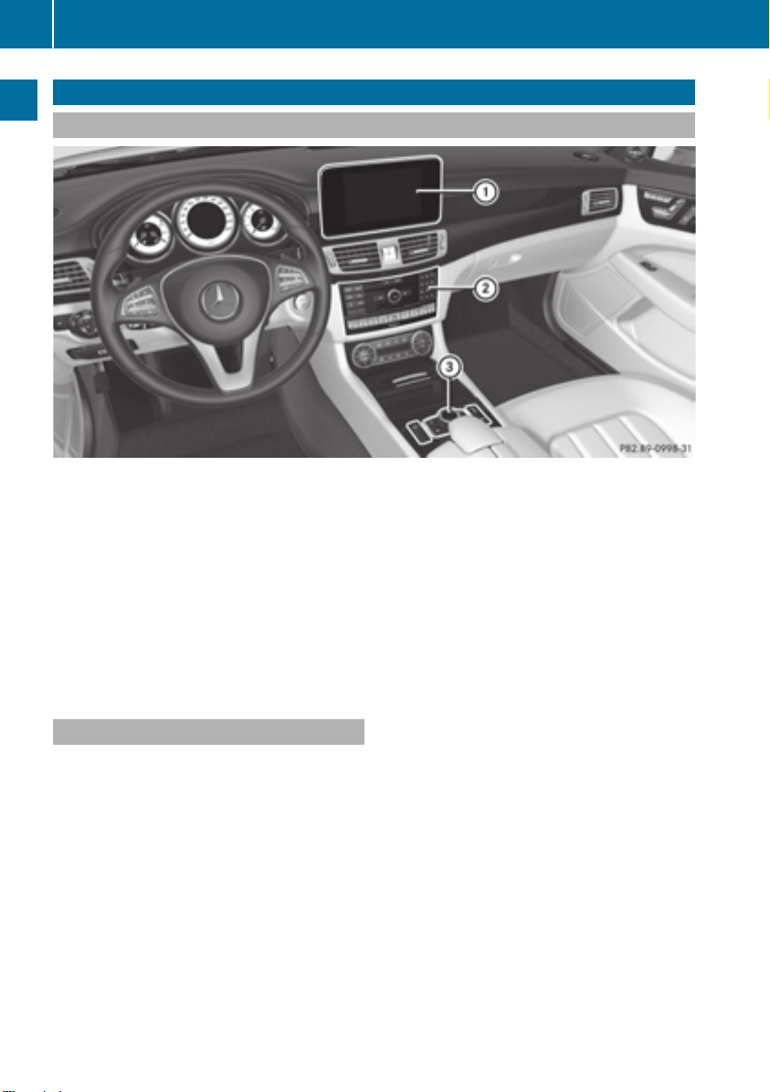
Components
Overview and operation
:
Display (Y page 19)
;
COMAND control panel (Y page 21)
=
Controller and buttons (Y page 18)
COMAND consists of:
R
the display
R
the COMAND control panel with a single drive or DVD changer
R
the controller and buttons
R
two connection options for USB or via Media Interface in the center console
An iPod®is connected via USB cable.
Functions
R
HD FM radio/HD AM radio/satellite
radio
Internet radio (call up via communication
functions)
R
Media
-
Media support: audio CD, MP3 CD, DVD
video, two connection options for USB or
via Media Interface, SD card, Bluetooth
audio
An iPod®, for example, can be connected
directly to the USB via the integrated
Media Interface.
-
Music search using all media
R
Sound system
You can select from two sound systems:
-
harman/kardon®Logic 7®surround
sound system
-
Bang & Olufsen BeoSound AMG sound
system
Page 21
R
Navigation system
-
Navigation via the hard drive
-
Destination entry, e.g. using keyword
search
-
Realistic 3D map with textured city models
-
Personal POIs and routes using SD memory card
-
Navigation functions, e.g. compass display
-
Dynamic route guidance with traffic
reports via SIRIUS satellite radio
R
Communication
-
Messaging functions (text messages,
email)
-
Address book
-
Internet browser
-
Mercedes-Benz Apps with Google Local
Search™, Destination/Route Download,
Weather, Facebook, Google Street
View™, Internet radio, stock prices,
news and much more
-
Mercedes-Benz Mobile Website
-
WiFi interface for the connection of a
smartphone to COMAND
-
WiFi hotspot functionality to connect a
tablet PC or laptop in order to enable
access to the Internet using the customer's mobile phone
R
SIRIUS Weather
-
Weather data as an information chart
(current forecast, 5-day preview,
detailed information)
-
Weather data on the weather map, e.g.
rain radar data, storm characteristics
and the track of tropical cyclones (hurricanes, tornadoes)
R
Vehicle functions
-
Vehicle settings, e.g. fuel consumption
-
360° camera
-
Rear view camera
-
Seat functions, e.g. setting driving
dynamics
R
Favorites button
Overview
Fast access to favorites functions using the
favorites button on the controller
Display
General notes
Do not use the space in front of the dis-
!
play for storage. Objects placed here could
damage the display or impair its function.
Avoid any direct contact with the display
surface. Pressure on the display surface
may result in impairments to the display,
which could be irreversible.
Wearing polarized sunglasses may impair
your ability to read the display.
The display has an automatic temperaturecontrolled switch-off feature. The brightness
is automatically reduced if the temperature is
too high. The display may then temporarily
switch off completely.
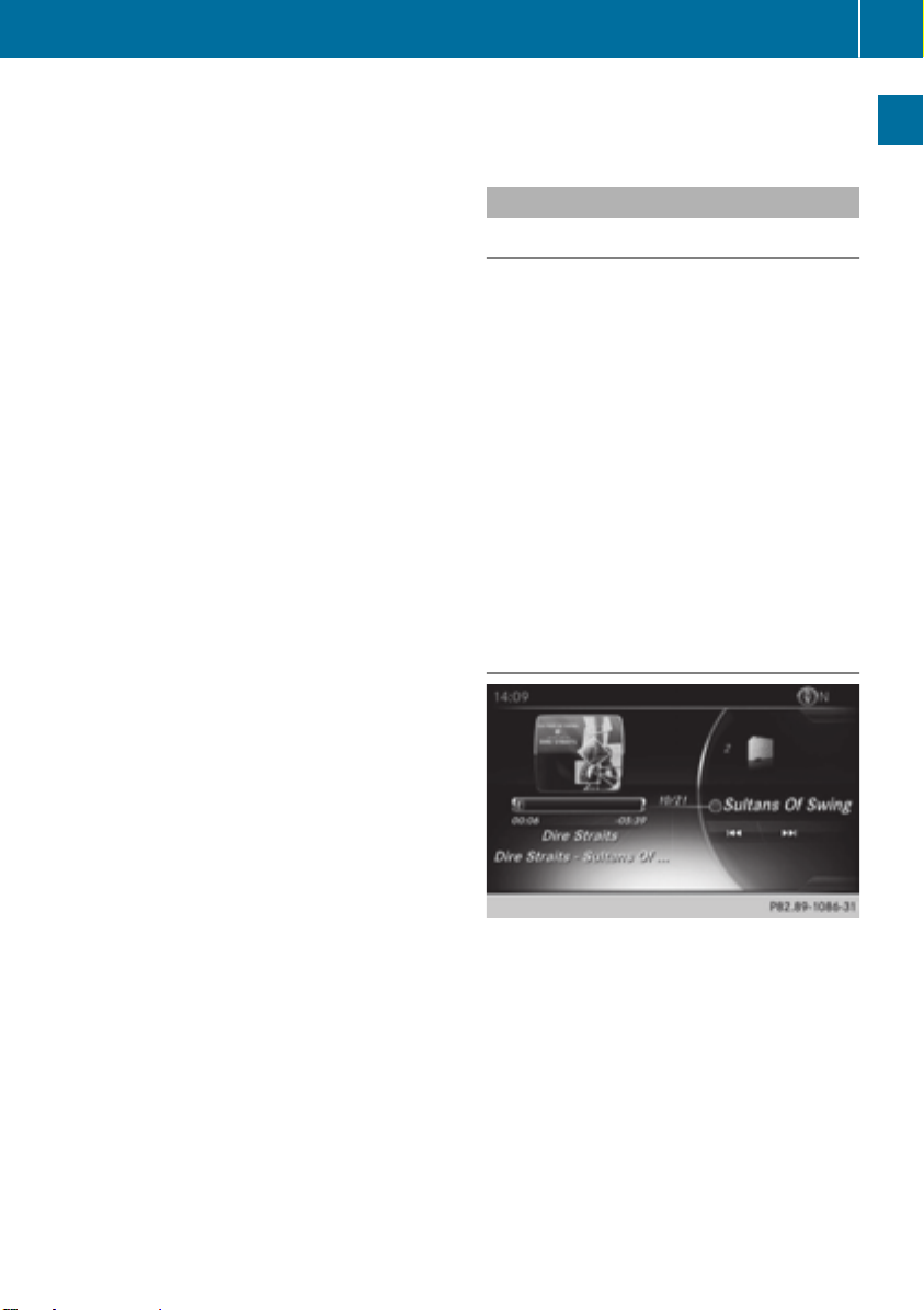
Overview
In the status bar at the top you will see the
time and other displays, depending on the
settings.
Below it you will see the main display field.
The climate control status display is briefly
displayed when you operate the climate control system.
The example shows media playback in SD
memory card mode.
19
Overview and operation
Page 22

Overview
20
Cleaning instructions
Do not touch the display. The display has
!
a very sensitive high-gloss surface; there is
a risk of scratching. If you have to clean the
screen, however, use a mild cleaning agent
and a soft, lint-free cloth.
The display must be switched off and have
cooled down before you start cleaning. Clean
the display screen, when necessary, with a
commercially available microfiber cloth and
cleaning agent for TFT/LCD displays. Do not
apply pressure to the display surface when
cleaning it, as this could cause irreversible
damage to the display. Then, dry the surface
Overview and operation
with a dry microfiber cloth.
Avoid using alcoholic thinners, gasoline or
abrasive cleaning agents. These could damage the display surface.
Page 23
COMAND control panel
Overview
21
Overview and operation
Function Page
:
Switches to radio mode 158
Calls up the Radio menu 159
;
Switches to the last selected media mode 170
Calls up the Media menu 170
=
Inserts and removes a disc
from the single CD/DVD
drive 174
Inserts a CD/DVD into the
DVD changer 174
Ejects a CD/DVD from the
DVD changer 175
?
Selects the previous station
from the station list 159
Skips backwards to a track 177
Rewinds 177
A
Loads/ejects the CD/DVD
8 Single drive
V DVD changer
B
Clear button 23
• Deletes characters
• Deletes an entry
174
174
Function Page
C
Selects the next station
from the station list 159
Skips forwards to a track 177
Fast forward 177
D
Number pad
• Saves a station 160
• Authorizes (connects) a
mobile phone 106
• Telephone number entry 109
• Searches for a contact 114
• Character entry 26
z Displays the current
track being played (if the
data medium supports
track information)
g Selects stations by
entering the frequency
manually 159
g Selects a track
E
Switches COMAND on/off 23
Adjusts the volume 23
F
Inserts/removes an SD
memory card 175
171
177
Page 24
22
Overview
Function Page
G
Accepts a call 109
Making a call 109
Redial 109
Accepts a new call when a
call is being made (call waiting) 112
H
Rejects a call 109
Ends an active call 113
I
Switches the sound on or
off 23
Overview and operation
Switches off navigation
announcements 24
Buttons and controller
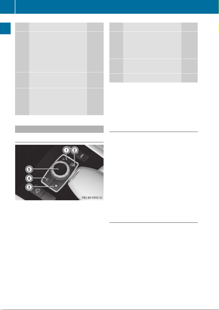
Overview
:
Clear button
;
Switches the display on/off
=
Favorites button (if available)
?
Back button
A
Controller
Instead of the display on/off button, the vehicle may be equipped with the T seat setting button.
For AMG vehicles: the controller is equipped
with buttons : and ?.
Function Page
J
Switches to navigation
mode 55
Calls up the navigation system menu 96
K
Calls up the telephone
menu 103
L
Calls up vehicle settings 46
Controller
The controller in the center console lets you:
R
select menu items on the display
R
enter characters
R
select a destination on the map
R
save entries
The controller can be:
R
turned 3
R
slid left or right 1
R
slid forwards or back 4
R
slid diagonally 2
R
press briefly or press and hold 7
Back button
You can use the % button to exit a menu or
to call up the basic display of the current
operating mode.
X
To exit the menu: briefly press the %
button.
COMAND changes to the next higher menu
level in the current operating mode.
X
To call up the basic display: press the
% button for longer than two seconds.
COMAND changes to the basic display of
the current operating mode.
Page 25
Basic functions
23
Clear button
X
To delete individual characters: briefly
press the j button.
X
To delete an entire entry: press and hold
the j button.
Favorites button
You can assign predefined functions using
the favorites button g and call them up by
pressing the button (Y page 41).
Display off button
You can switch the display on and off with the
_ button (Y page 33).
Seat button
If the controller is equipped with the T
button, you can call up the menu for seat settings (Y page 48).
Basic functions
Switching COMAND on/off
X
Press the q control knob.
When you switch on COMAND, a warning
message will appear. COMAND calls up the
previously selected menu.
If you switch off COMAND, playback of the
current media source will also be switched
off.
Adjusting the volume
Adjusting the volume for media sources
X
Turn the q control knob.
or
X
Press the W or X button on the multifunction steering wheel.
The volume of the media source currently
selected changes.
Adjusting the volume for traffic
announcements and navigation
announcements
During traffic or navigation announcements:
X
Turn the q control knob.
or
X
Press the W or X button on the multifunction steering wheel.
You can set the volume for navigation
i
announcements to be different from the
volume of the respective media source.
Adjusting the volume for phone calls
You can adjust the volume for hands-free
mode during a telephone call.
X
Turn the q control knob.
or
X
Press the W or X button on the multifunction steering wheel.
Setting the volume for the Voice Control
i
System voice output, see the separate
operating instructions.
Switching the sound on or off
Media source sound
X
Press the 8 button on the COMAND
controller or the multifunction steering
wheel.
The sound is switched off. If the audio output is switched off, the status line will show
the 8 symbol. If you switch the media
source or change the volume, the sound is
automatically switched on.
Even if the sound is switched off, you will
i
still hear navigation system announcements.
Overview and operation
Page 26
Basic functions
24
Switching navigation announcements
off and on again
X
To switch navigation announcements
off: press the 8 button during an
announcement.
The SpokenSpoken drivingdriving recommendationsrecommendations
have been deactivated.have been deactivated. message
appears.
X
To switch navigation announcements
back on: switch COMAND off and then on
again (Y page 23).
or
X
Start a new route calculation (Y page 61).
Overview and operation
or
X
Select +: while route guidance is active,
show the menu and press the controller
(Y page 80).
Function menu
X
To show the menu: slide 4 the con-
troller.
The menu for the selected functions
appears. Depending on the operation, the
marking is shown in main function bar (top)
or menu bar (bottom).
X
To select a menu item: turn and press the
controller.
If you have selected a menu item from the
main function bar, switch to the last menu
set for the selected function.
The menu bar features options within the
currently set function.
Selecting the operating mode for a
main function
For the main functions, e.g. communication
or media, you can choose from the available
operating modes.
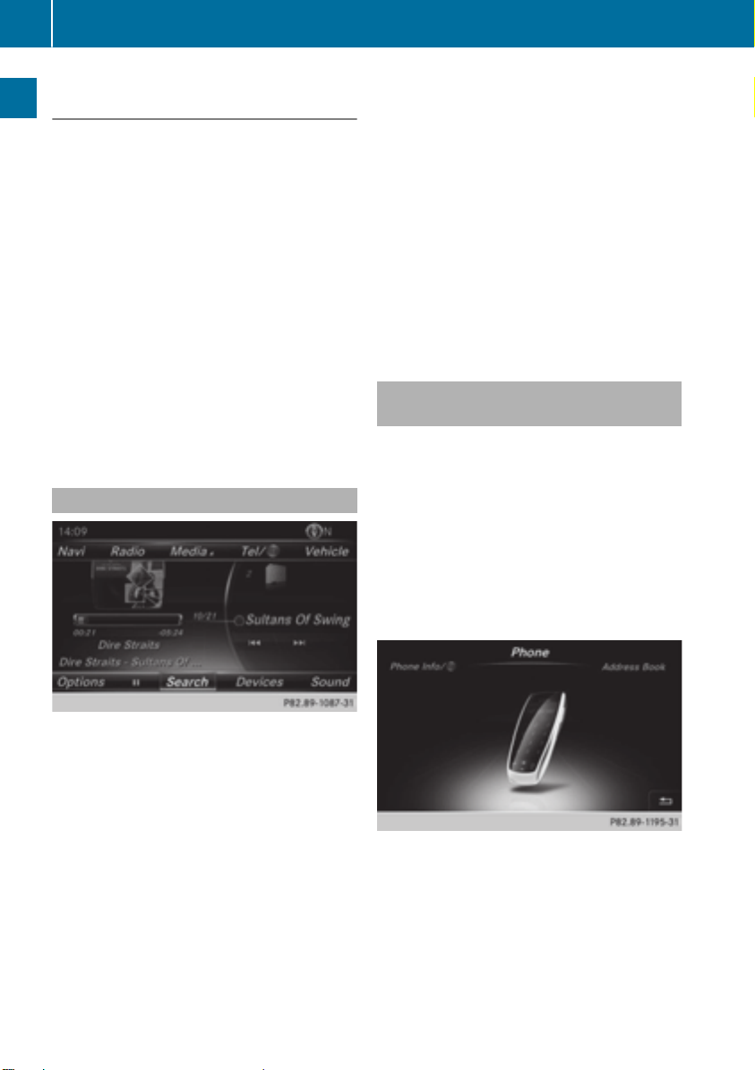
In the communication menu, you can:
R
switch to telephone mode
R
call up the address book
R
call up the Internet
R
call up the digital operating instructions for
the telephone/®
X
Press the Õ button or the ß, $,
%, or Ø button.
Navigation: the map displays the current
vehicle position.
Radio: the basic menu of the last radio
mode set appears.
Media: the basic display for the last media
source set appears. In the example, SD
memory card mode is set.
Communication: the basic menu of the
last communication function set appears
(telephone, address book, Internet).
Vehicle functions: the basic display
appears.
X
Press the % button.
The phone menu appears.
X
To call up the menu: press the % but-
ton again.
or
Page 27
Character entry (telephony)
25
X
To select Tel/Tel/®: slide 5 and press the
controller.
The communication menu appears. PhonePhone
is at the front.
X
To select Internet, for instance, turn and
press the controller.
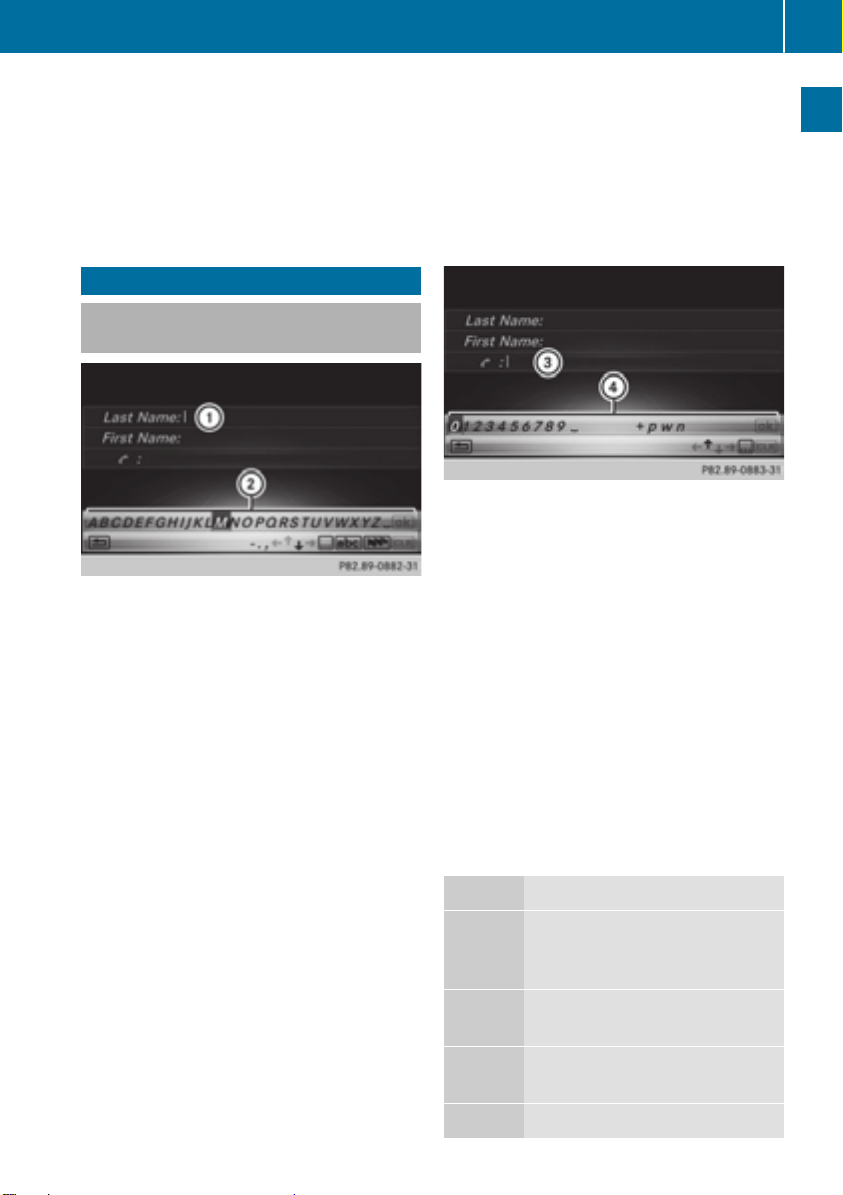
Character entry (telephony)
Entering characters using the character bar
In the example, a new entry is added to the
phone book (Y page 115). The new entry has
three input lines for entering the last name,
first name and phone number. The input line
for the surname is selected automatically.
Entering characters
X
Turn and press the controller.
The character selected in character bar ;
is entered into surname input line :.
X
Enter the complete last name.
Deleting individual characters
X
To switch to the bottom line of the character bar: slide 6 the controller.
X
To select F: turn and press the controller.
The character last entered is deleted.
Deleting an entire entry
X
To switch to the bottom line of the character bar: slide 6 the controller.
X
To select F: turn and hold the controller
until the entire entry has been deleted.
Switching input line
X
To switch to the bottom line of the character bar: slide 6 the controller.
X
To select 5: turn and press the controller.
The input line for the first name is selected.
You can enter the characters for the first
name.
When the telephone number input line is
selected, the character bar is adapted for
entering digits.
Entering characters
X
Turn and press the controller.
The character selected in character bar ?
is entered into telephone number input line
=.
Finishing an entry and saving a contact
X
To switch to the bottom line of the character bar: slide 6 the controller.
X
To select ¬: turn and press the controller.
Further functions available in the character bar
Symbol Function
Ä
Switches the character bar for
entering characters, digits and
symbols
*
Switches the character bar to
uppercase/lowercase letters
B
Changes the country setting for
the character bar
Overview and operation
F
Deletes a character/an entry
Page 28
Character entry (navigation)
26
Symbol Function
4, 5 Selects the input line
2, 3 Moves the cursor within the
input line
b
%
S
Confirms an entry
Cancels input
Inserts a paragraph
Entering characters using the number
keypad
Overview and operation
If an input line for text or numbers is selected,
the number keypad is used for the character
entry.
X
For example, to enter the letter cc: press the
l number key briefly three times in succession.
An additional display area is shown with all
the available characters. Press the key
repeatedly to go through the characters
until cc is highlighted.
X
Wait until the character display goes out.
The letter cc is entered in the input line.
Character entry (navigation)
Entering characters using the character bar
=
Characters not currently available
?
Currently selected character
A
Characters currently available
B
Character bar
The example shows the address entry
(Y page 60).
X
To enter a character: turn, slide 6 or
5 and press the controller.
Selected character : is entered in the
upper line. COMAND adds the missing
characters and shows the entry that best
matches the current input.
The characters are available A or not =,
depending on the characters already
entered and the data stored in the digital
map.
The G symbol indicates that an entry
exists more than once.
X
To delete a character: slide 6 and turn
the controller, then press it after selecting
F.
X
To delete an entire entry: slide 6 and
turn the controller; then after selecting F
press and hold down the controller until the
entire entry is deleted.
X
To confirm an entry: slide 6 and turn
the controller, then press it after selecting¬.
or
X
Slide 5 the controller repeatedly until the
character bar disappears.
The location selection list appears. The
selected entry is highlighted.
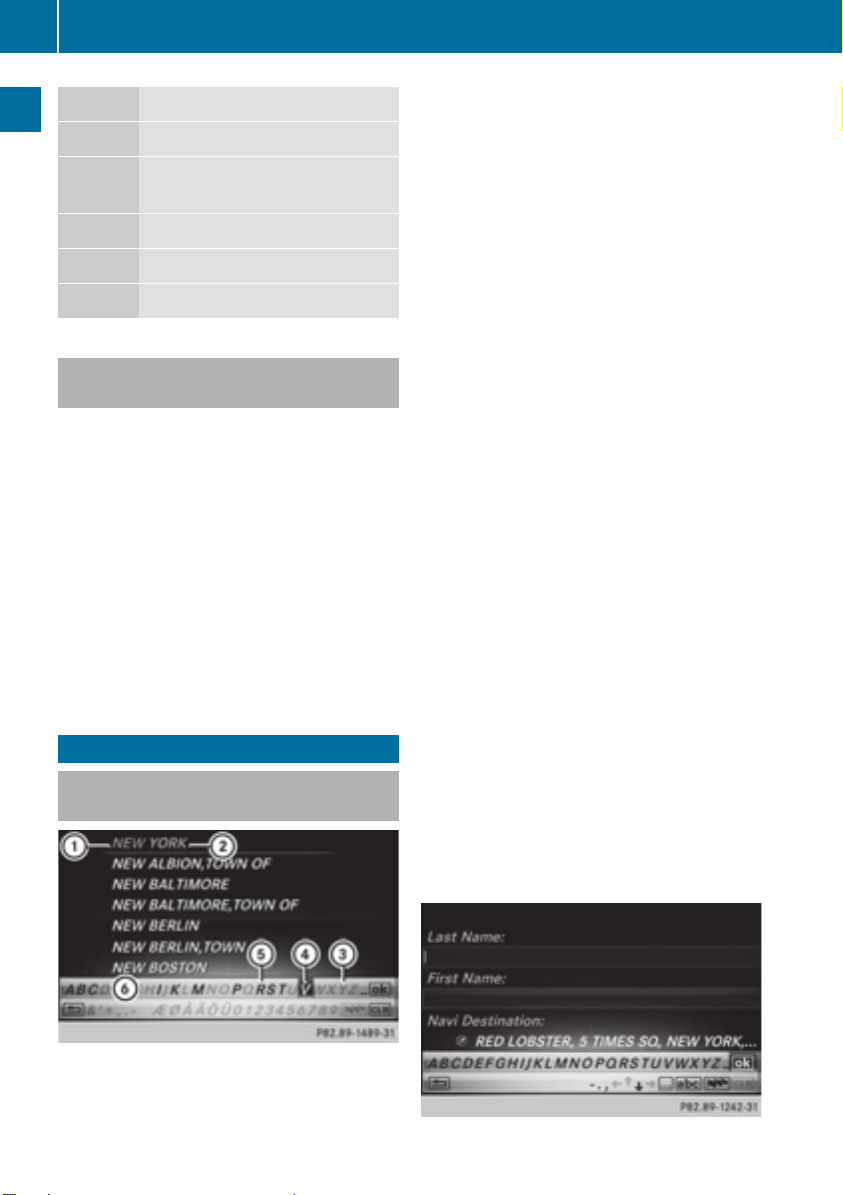
:
Characters NEWNEW (orange-color) entered by
the user
;
Characters YORKYORK automatically added by
COMAND
Page 29
Character entry (navigation)
27
The example shows the character entry when
you save a destination as a navigable contact
in the address book (Y page 61). The cursor
is located in the input line.
X
To select an input line: slide 6 and turn
the controller, then press it after selecting
4 or 5.
or
X
Slide 5 the controller repeatedly until the
character bar disappears.
X
Turn and press the controller.
X
To move the cursor: select the input line.
X
Slide 6 and turn the controller, then
press it after selecting 2 or 3.
X
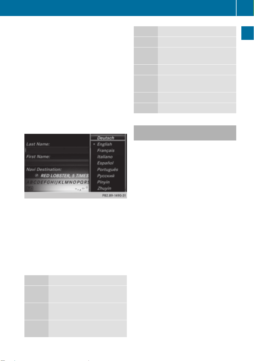
To change the character bar language:
slide 6 and turn the controller, then
press it after selecting B.
A menu appears.
X
To select the language: turn and press the
controller.
The character set for the selected language
is set.
The character bar entry functions are listed in
the table.
Symbol Function
F
è
Deletes a character/an entry
Switches to keyword search
(Y page 62)
4, 5 Selects the input line
2, 3 Moves the cursor within the
input line
¬
&
Confirms an entry
Cancels input
Entering characters using the number
keypad
X
Press one of the number keypad buttons,
e.g. l, once or repeatedly in quick succession.
The character appears at the bottom of the
display when the key is pressed. The first
available letter is highlighted.
You see which characters you can enter
with that key. Each time the key is pressed,
the next character is selected.
X
Wait until the character display goes out.
The entries matching your input are shown
in the list.
Overview and operation
Symbol Function
Ä
Switches between digits and
symbols
*
Switches the character bar to
uppercase/lowercase letters
B
Changes the character bar language
Page 30
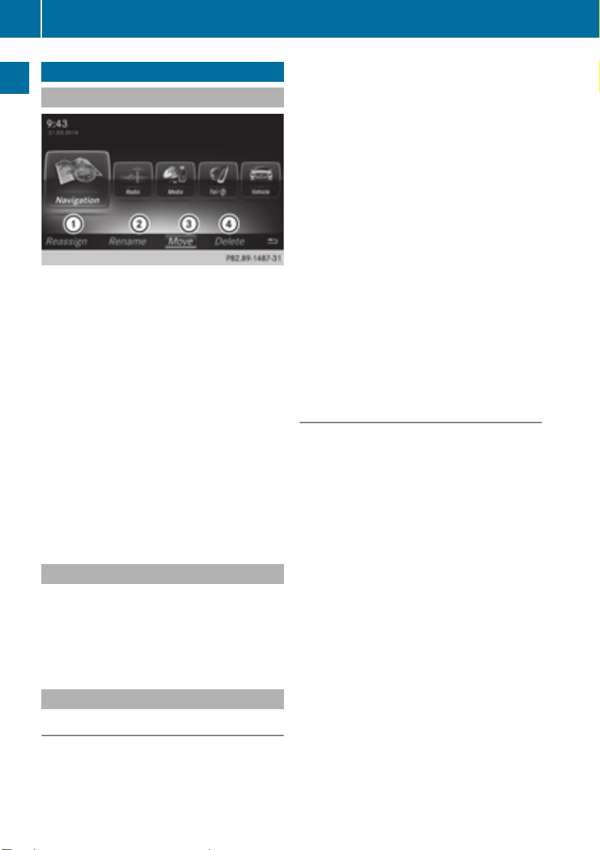
Favorites
28
Favorites
Overview of favorites
:
To add a new favorite (Y page 28)
Overview and operation
;
To rename a selected favorite
(Y page 29)
=
To move a selected favorite
(Y page 29)
?
To delete a selected favorite
(Y page 29)
Displaying the favorites overview
X
Press the favorites button on the controller.
The favorites are displayed.
X
To show the menu bar: slide 6 the controller.
You can manage a total of 20 favorites.
Further information on how to select and display a favorite (Y page 28).
Displaying and selecting favorites
X
Press the favorites button on the controller.
The favorites are displayed.
X
To select a favorite: turn the controller.
X
To call up a favorite: press the controller.
Adding favorites
X
To select Assign NewAssign New: turn and press the
controller.
The categories for the available favorites
are displayed.
R
NavigationNavigation
R
EntertainmentEntertainment
R
TelTel
R
VehicleVehicle
R
Climate ControlClimate Control
X
To select a category: turn the controller and
press to confirm.
The corresponding favorites are displayed.
X
To select the desired favorite: turn and
press the controller.
X
To store the favorite in the desired order:
turn and press the controller.
The favorite has been added.
If a favorite is stored over another favorite,
the favorite underneath is deleted.
Adding your own favorites
You can store phone numbers from the phone
book, radio stations or destinations as favorites.
A phone number from the phone book is used
as an example.
X
Call up the phone book (Y page 113).
X
Search for the contact and display the
phone number: (Y page 114).
X
To store the phone number as a favorite:
press and hold the favorites button on the
controller until the favorites are displayed.
X
To store the favorite in the desired order:
turn and press the controller.
The favorite has been added.
If a favorite is stored over another favorite,
the favorite underneath is deleted.
Adding predefined favorites
X
Press the favorites button on the controller.
The favorites are displayed.
X
To show the menu bar: slide 6 the controller.
Page 31

Favorites
29
Renaming favorites
X
Press the favorites button on the controller.
The favorites are displayed.
X
To select the favorite to be renamed: turn
the controller.
X
To show the menu bar: slide 6 the controller.
X
To select RenameRename: turn and press the con-
troller.
X
Enter characters using the controller
(Y page 25).
X
To finish the entry: select OKOK.
The favorite has been renamed.
Moving favorites
Deleting favorites
X
Press the favorites button on the controller.
The favorites are displayed.
X
To select the favorite to be deleted: turn the
controller.
X
To show the menu bar: slide 6 the controller.
X
To select DeleteDelete: turn and press the con-
troller.
X
To select YesYes: turn and press the controller.
The favorite is deleted.
or
X
To select NoNo: turn and press the controller.
The process is canceled.
Overview and operation
X
Press the favorites button on the controller.
The favorites are displayed.
X
To select the favorite to be moved: turn the
controller.
X
To show the menu bar: slide 6 the controller.
X
To select MoveMove: turn and press the control-
ler.
X
To store the favorite in the desired order:
turn and press the controller.
The favorite has been moved.
If a favorite is stored over another favorite,
the favorite underneath is deleted.
Page 32

30
Page 33

Your COMAND equipment .................. 32
Important safety notes ....................... 32
Display settings ................................... 32
Time settings ....................................... 33
Text reader settings ............................ 36
Voice Control System settings .......... 36
WiFi ...................................................... 36
Bluetooth®settings ............................ 40
Setting the system language ............. 40
Calling up the favorite functions ....... 41
Importing/exporting data .................. 41
Reset function ..................................... 43
31
System settings
Page 34

Display settings
32
Your COMAND equipment
These operating instructions describe all
standard and optional equipment available
for your COMAND system at the time of purchase. Country-specific differences are possible. Please note that your COMAND system
may not be equipped with all the features
described. This also applies to safety-relevant
systems and functions. Therefore, the equipment on your COMAND system may differ
from that in the descriptions and illustrations.
Should you have any questions concerning
System settings
equipment and operation, please consult an
authorized Mercedes-Benz Center.
Important safety notes
WARNING
G
If you operate mobile communication equipment while driving, you will be distracted from
traffic conditions. You could also lose control
of the vehicle. There is a risk of an accident.
Only operate this equipment when the vehicle
is stationary.
You must observe the legal requirements for
the country in which you are currently driving
when operating mobile communications
equipment in the vehicle.
WARNING
G
SD memory cards are small parts. They can be
swallowed and cause asphyxiation. This
poses an increased risk of injury or even fatal
injury.
Keep SD memory cards out of the reach of
children. If an SD memory card is swallowed,
seek immediate medical attention.
Display settings
Setting the brightness
The brightness detected by the display light
sensor affects the setting options for this
function.
X
Press the Ø button on the COMAND
control panel.
or
X
Press VehicleVehicle in the main function bar.
The vehicle menu is displayed.
X
To select System SettingsSystem Settings: slide 6,
turn and press the controller.
A menu appears.
X
To select DisplayDisplay: turn and press the con-
troller.
A menu appears.
X
Select BrightnessBrightness.
A control appears.
X
To select the desired brightness: turn and
press the controller.
Display design
The display features optimized designs for
daytime and night-time operation. You can
set the design by manually selecting day or
night design or opt for an automatic setting.
X
Press the Ø button on the COMAND
control panel.
or
X
Press VehicleVehicle in the main function bar.
The vehicle menu is displayed.
Page 35

Time settings
33
X
To select System SettingsSystem Settings: slide 6,
turn and press the controller.
A menu appears.
X
To select DisplayDisplay: turn and press the con-
troller.
A menu appears.
X
To select Day ModeDay Mode, Night ModeNight Mode or AutoAuto:
turn and press the controller.
The # dot indicates the current setting.
Design Explanation
Day ModeDay Mode
The display is set permanently to day design.
Night ModeNight Mode
The display is set permanently to night design.
AutoAuto If the AutoAuto setting is
selected, COMAND evaluates the readings from
the automatic vehicle
light sensor and automatically switches
between the display
designs.
Switching the display on/off
X
Press the Ø button on the COMAND
control panel.
X
To select DisplayDisplay OffOff: slide 6, turn and
press the controller to confirm.
The display goes out.
or
X
Press the _ button on the controller.
The display goes out.
X
To switch the display on again: press the
controller.
Time settings
General information
COMAND can automatically set the time and
date.
The following navigation system functions
require the time, time zone and summer/
standard time to be set correctly in order to
work properly:
R
route guidance on routes with timedependent traffic guidance
R
calculation of expected time of arrival
Switching automatic time on and off
The Automatic Time SettingsAutomatic Time Settings function is
used to activate or deactivate the automatic
setting of the time and date. This function is
activated when the vehicle leaves the factory.
X
Press the Ø button on the COMAND
control panel.
or
X
Press VehicleVehicle in the main function bar.
The vehicle menu is displayed.
X
To select TimeTime: slide 6, turn and press
the controller to confirm.
A menu appears.
X
To select Automatic Time SettingsAutomatic Time Settings:
press the controller.
X
To switch the function on O or off ª:
press the controller.
Setting the time zone
To set the time zone, the Automatic TimeAutomatic Time
SettingsSettings function must be activated.
X
Press the Ø button on the COMAND
control panel.
or
X
Press VehicleVehicle in the main function bar.
The vehicle menu is displayed.
X
To select TimeTime: slide 6, turn and press
the controller to confirm.
A menu appears.
X
To select Time Zone:Time Zone:: turn and press the
controller.
A list of countries appears. The # dot indicates the current setting.
System settings
Z
Page 36

Time settings
34
X
Select the country you are currently in by
turning and pressing the controller.
The country is accepted.
A time zone list may also be displayed,
depending on the country selected.
X
To select the desired time zone: turn and
press the controller.
The time zone is accepted.
A list of available options for setting summer time appears (Y page 34).
Setting Function
AutomaticAutomatic
The summer and
standard time are
automatically
changed over.
OnOn
The clock is
advanced one hour
ahead of standard
time.
Setting summer and standard time
System settings
The Daylight Saving TimeDaylight Saving Time menu is not
available in all countries.
You can use the Daylight Saving TimeDaylight Saving Time
menu to set automatic summer time changeover or switch the summer time setting on or
off. The changeover to summer time advances the time by one hour.
X
Press the Ø button on the COMAND
control panel.
or
X
Press VehicleVehicle in the main function bar.
The vehicle menu is displayed.
X
To select TimeTime: slide 6, turn and press
the controller to confirm.
A menu appears.
X
To select Daylight Saving TimeDaylight Saving Time: turn
and press the controller.
A list of available options for setting summer time appears.
X
To select AutomaticAutomatic, OnOn or OffOff: turn and
press the controller.
OffOff
The standard time
for the chosen time
zone is selected.
Manual time setting
Using the manual time settings, you can
i
set the time forwards or backwards by up to
several hours.
X
Press the Ø button on the COMAND
control panel.
or
X
Press VehicleVehicle in the main function bar.
The vehicle menu is displayed.
X
To select TimeTime: slide 6, turn and press
the controller to confirm.
A menu appears.
X
To select Set Time ManuallySet Time Manually: turn and
press the controller.
A menu with an analog clock appears.
X
To set the hour: turn the controller.
Page 37

X
To highlight the minutes: slide 9 the
controller.
X
To set minutes: turn and press the controller.
The time is accepted.
The Automatic Time SettingsAutomatic Time Settings function
is deactivated ª.
If AutomaticAutomatic is set for the summer time
changeover, a prompt will appear asking
whether the automatic changeover should
be maintained between summer and winter
time.
If Automatic Time SettingsAutomatic Time Settings is reacti-
i
vated, the previous settings for time zone
and summer time changeover are restored.
Setting the time and date format
Use this function to set the time and date format for all displays in the vehicle.
X
Press the Ø button on the COMAND
control panel.
or
X
Press VehicleVehicle in the main function bar.
The vehicle menu is displayed.
X
To select TimeTime: slide 6, turn and press
the controller to confirm.
A menu appears.
X
To select FormatFormat: turn and press the con-
troller.
X
To select the desired date format: turn and
press the controller.
The # dot indicates the current setting.
X
To select the desired time format: turn and
press the controller.
The # dot indicates the current setting.
Time settings
Abbreviation Meaning
DD.MM.YYYYDD.MM.YYYY
DD/MM/YYYYDD/MM/YYYY
MM/DD/YYYYMM/DD/YYYY
YY/MM/DDYY/MM/DD
YYYY/MM/DDYYYY/MM/DD
YYYY-MM-DDYYYY-MM-DD
HH:MM (24 hrs)HH:MM (24 hrs)
Day.Month.
Year
date format,
year (all four
digits)
Day/Month/
Year
date format,
year (all four
digits)
Month/Day/
Year
date format,
year (all four
digits)
Year/
Month/Day
date format,
year (two digits)
Year/
Month/Day
date format,
year (all four
digits)
Day - Month Year
date format,
year (all four
digits)
Hours : Minutes
(24 hour time
format)
35
System settings
HH:MM (AM/PM)HH:MM (AM/PM)
Hours : Minutes
(AM/PM time
format)
Z
Page 38

36
WiFi
Text reader settings
X
Press the Ø button on the COMAND
control panel.
or
X
Press VehicleVehicle in the main function bar.
The vehicle menu is displayed.
X
To select System SettingsSystem Settings: slide 6,
turn and press the controller to confirm.
A menu appears.
X
To select Text Reader SpeedText Reader Speed: turn and
press the controller.
System settings
A list appears.
X
Select FastFast, MediumMedium or SlowSlow.
The # dot indicates the current setting.
Voice Control System settings
Opening/closing the help window
If the set system language is not suppor-
i
ted by the Voice Control System, English
will be selected.
The help window also shows you information
on audible instructions:
R
during individualization
R
during subsequent operation of the Voice
Control System.
X
Press the Ø button on the COMAND
control panel.
X
To select System SettingsSystem Settings: slide 6,
turn and press the controller.
A menu appears.
X
To select Voice ControlVoice Control: turn and press
the controller.
X
Select Help WindowHelp Window.
You have switched the help window on O
or off ª.
More information on the Voice Control System is available in the separate operating
instructions.
Individualization
Using individualization, you can fine-tune the
Voice Control System to your own voice. This
will help improve voice recognition (see the
separate operating instructions).
WiFi
Overview
USA:
To establish a WiFi connection between
COMAND and a WiFi-enabled device, such as
a tablet computer or smartphone:
R
WiFi must be activated at COMAND and at
the device to be connected.
If COMAND is to be used as a WiFi hotspot:
R
COMAND must be connected to an Internet-enabled mobile phone via Bluetooth
®
or USB.
R
The Internet access data for the mobile
phone network provider must be selected
or set for COMAND.
R
There must be an Internet connection to
COMAND.
Canada:
Prerequisites for establishing a WiFi connection between COMAND and a WiFi hotspot for
a WiFi-enabled device, such as a smartphone,
or another hotspot:
R
WiFi must be activated on COMAND.
R
the mobile WiFi hotspot on the smartphone
to be used as a hotspot must be activated.
Page 39

Activating WiFi (USA)
X
Press the Ø button on the COMAND
control panel.
or
X
Press VehicleVehicle in the main function bar.
The vehicle menu is displayed.
X
To switch to the menu bar: slide 6 the
controller.
X
To select System SettingsSystem Settings: press the
controller.
X
To select WiFiWiFi: turn and press the control-
ler.
The WiFi menu appears.
X
To select the ActivateActivate O option: press
the controller.
WiFi
X
To switch to the menu bar: slide 6 the
controller.
X
To select System SettingsSystem Settings: press the
controller.
X
To select WiFiWiFi: turn and press the control-
ler.
The WiFi menu appears.
X
To select the ActivateActivate O option: press
the controller.
Available WiFi hotspots are searched for
and displayed.
Connecting the device
General notes
The exact WiFi connection procedure may
i
vary depending on the device to be connected. Follow the instructions that are
shown in the display. Further information
can be found on the operating instructions
for the device you wish to connect.
Selecting a hotspot (Canada)
37
System settings
Activating WiFi (Canada)
X
Press the Ø button on the COMAND
control panel.
or
X
Press VehicleVehicle in the main function bar.
The vehicle menu is displayed.
X
Press the Ø button on the COMAND
control panel.
or
X
Press VehicleVehicle in the main function bar.
The vehicle menu is displayed.
X
To switch to the menu bar: slide 6 the
controller.
X
To select System SettingsSystem Settings: press the
controller.
Z
Page 40

38
WiFi
X
To select WiFiWiFi: turn and press the control-
ler.
The WiFi menu appears. A search for hotspots is carried out.
X
To select a hotspot: turn and press the controller.
A menu for making the connection appears.
Connecting a device via WPS PIN (USA)
System settings
Prerequisite:
For this type of connection, the device to be
connected must support "Connect using WPS
PIN".
X
Select Connect via WPS PINConnect via WPS PIN.
X
Select the vehicle from the device to be
connected and "Connect using WPS PIN".
The vehicle is displayed with the SSID MBMB
HOTSPOT XXXXXHOTSPOT XXXXX.
The device to be connected generates a
PIN.
X
This PIN is also entered on COMAND.
X
To confirm the entry: press the controller.
Connecting a device via WPS PIN (Canada)
Prerequisite:
For this type of connection, the device to be
connected must support "Connect using WPS
PIN".
X
Press the Ø button on the COMAND
control panel.
or
X
Press VehicleVehicle in the main function bar.
The vehicle menu is displayed.
X
To switch to the menu bar: slide 6 the
controller.
X
Select System SettingsSystem Settings.
The System SettingsSystem Settings menu is displayed.
X
To select WiFiWiFi: turn and press the control-
ler.
The WiFi menu appears.
X
Select one of the hotspots that has been
found.
A menu for making the connection appears.
X
Select Connect via WPS PINConnect via WPS PIN.
X
Enter the WPS PIN generated by COMAND
into the device.
X
To confirm the entry: press the controller.
Connecting a device via WPS PBC (USA)
Prerequisite:
For this type of connection, the device to be
connected must support "Connect via push
button".
X
Press the Ø button on the COMAND
control panel.
or
X
Press VehicleVehicle in the main function bar.
The vehicle menu is displayed.
X
To switch to the menu bar: slide 6 the
controller.
X
To select System SettingsSystem Settings: press the
controller.
X
Select WiFiWiFi.
The WiFi menu appears.
X
Select Connect via WPS PBCConnect via WPS PBC.
X
Select the vehicle from the device to be
connected and Connect via WPS PBCConnect via WPS PBC.
Page 41

The vehicle is displayed with the SSID MBMB
HOTSPOT XXXXXHOTSPOT XXXXX.
X
To confirm the entry: press the controller.
Connecting a device via WPS PBC (Canada)
Prerequisite:
For this type of connection, the device to be
connected must support "Connect via push
button".
X
Press the Ø button on the COMAND
control panel.
or
X
Press VehicleVehicle in the main function bar.
The vehicle menu is displayed.
X
To switch to the menu bar: slide 6 the
controller.
X
To select System SettingsSystem Settings: press the
controller.
X
Select WiFiWiFi.
The WiFi menu appears.
X
To select one of the hotspots that has been
found: turn and press the controller.
A menu for making the connection appears.
X
Select Connect via WPS PBCConnect via WPS PBC.
X
Press the pushbutton on your device.
X
To confirm the entry: press the controller.
Generating a new security key (USA)
WiFi
X
Press the Ø button on the COMAND
control panel.
or
X
Press VehicleVehicle in the main function bar.
The vehicle menu is displayed.
X
To switch to the menu bar: slide 6 the
controller.
X
To select System SettingsSystem Settings: press the
controller.
X
To select WiFiWiFi: turn and press the control-
ler.
The WiFi menu appears.
X
To select Generate Security KeyGenerate Security Key: turn
and press the controller.
X
To select RegenerateRegenerate:press the controller.
A new security key is generated.
X
To save the security key: turn the controller
and select SaveSave.
The WiFi menu appears. The new security
key will now be displayed and verified when
a connection is established via the security
key. The connection must be re-established with the newly created security key.
Device connections established using the
i
previous security key will no longer work
after the security key is changed. You have
to reconnect these devices (Y page 37).
Changing the name of the SSID (USA)
39
System settings
X
Press the Ø button on the COMAND
control panel.
or
X
Press VehicleVehicle in the main function bar.
The vehicle menu is displayed.
Z
Page 42

Setting the system language
40
X
To switch to the menu bar: slide 6 the
controller.
X
To select System SettingsSystem Settings: press the
controller.
X
To select WiFiWiFi: turn and press the control-
ler.
The WiFi menu appears.
X
To select ChangeChange SSIDSSID: turn and press the
controller.
A dialog for entering the SSID appears.
X
Enter the new SSID.
X
To select ¬: turn and press the control-
System settings
ler.
The new SSID is shown on the device to be
connected and in the Connect UsingConnect Using
Security KeySecurity Key menu.
Device connections established using the
i
previous SSID will no longer work after the
SSID is changed. You have to reconnect
these devices (Y page 37).
Bluetooth®settings
General information about Blue-
®
tooth
Bluetooth®-capable devices, e.g. mobile
phones, have to comply with a certain profile
in order to be connected to COMAND. Every
Bluetooth®device has its own specific Bluetooth®name.
Bluetooth®technology is a standard for
short-range wireless data transmissions up to
approximately 10 meters. You can use Bluetooth®to connect your mobile phone to
COMAND to, for example:
R
use the hands-free system
R
establish an Internet connection
R
listen to music using Bluetooth®Audio
R
exchange vCards
Bluetooth®is a registered trademark of Bluetooth Special Interest Group (SIG) Inc.
Activating/deactivating Bluetooth
X
Press the Ø button on the COMAND
®
control panel.
or
X
Press VehicleVehicle in the main function bar.
The vehicle menu is displayed.
X
To select System SettingsSystem Settings: slide 6,
turn and press the controller.
A menu appears.
X
To select Activate BluetoothActivate Bluetooth: turn and
press the controller.
This switches Bluetooth®on O or off ª.
Setting the system language
This function allows you to determine the language for the menu displays and the navigation messages. The selected language affects
the characters available for entry.
The navigation announcements are not
i
available in all languages. If a language is
not available, the navigation announcements will be in English.
When you set the system language, the
i
language of the Voice Control System will
change accordingly. If it is not supported by
the Voice Control System, English will be
selected.
X
Press the Ø button on the COMAND
control panel.
or
X
Press VehicleVehicle in the main function bar.
The vehicle menu is displayed.
Page 43

Importing/exporting data
41
X
To select System SettingsSystem Settings: slide 6,
turn and press the controller to confirm.
A menu appears.
X
To select LanguageLanguage: turn and press the
controller.
The list of languages appears. The # dot
indicates the current setting.
X
Select the desired language.
COMAND loads the selected language and
sets it.
Calling up the favorite functions
The Favorites function can, depending on the
vehicle equipment, be called up as follows:
R
via the System SettingsSystem Settings menu
R
via the Favorites button on the controller
(Y page 18)
Calling up the Favorites function via the
system menu:
X
Press the Ø button on the COMAND
control panel.
or
X
Press VehicleVehicle in the main function bar.
The vehicle menu is displayed.
X
To select SystemSystem SettingsSettings: slide 6 and
press the controller.
A menu appears.
X
To select Favorite FunctionsFavorite Functions: press the
controller.
The favorites are displayed.
X
To select the desired function, e.g. Phone‐Phone‐
bookbook: turn and press the controller.
A menu appears.
Calling up the Favorites function using
the controller:
X
Press the favorites button on the controller.
The favorites are displayed.
X
To select the desired function, e.g. Phone‐Phone‐
bookbook: turn and press the controller.
The Favorites function can be exited at any
time.
To exit the Favorites function:
X
Press the Favorites button again
or
X
Press % on the controller.
or
X
To select % in the display: turn and
press the controller.
Further information on the Favorites function
(Y page 28).
Importing/exporting data
General notes
Never remove the stick or card when writ-
!
ing data to the USB stick or the memory
card. You may otherwise lose data.
Using this function, you can:
R
transfer your personal COMAND data from
one system/vehicle to another.
R
make a backup copy of your personal data
(export data) and load it again (import
data).
R
protect your data from unwanted export by
activating a PIN prompt (presetting: deactivated ª).
You can either use an SD memory card or a
USB storage device (e.g. a USB stick) as temporary storage.
System settings
Z
Page 44

Importing/exporting data
42
Activating/deactivating PIN protection
System settings
X
Press the Ø button on the COMAND
control panel.
or
X
Press VehicleVehicle in the main function bar.
The vehicle menu is displayed.
X
To select System SettingsSystem Settings: slide 6,
turn and press the controller.
A menu appears.
X
To select Data Import/ExportData Import/Export: turn and
press the controller.
X
Select Activate PIN ProtectionActivate PIN Protection.
Activate O or deactivate ª PIN protection. When activating PIN protection, you
will be prompted to enter a PIN.
X
To enter the 4-digit PIN and select ¬:
turn and press the controller.
You will be prompted to enter the PIN
again.
X
Enter the PIN again and select ¬.
The PIN prompt now protects your personal
data from unwanted export.
If you deactivate your PIN protection, you
i
will first be prompted to enter your PIN. If
you have forgotten your PIN, an authorized
Mercedes-Benz Center can deactivate your
PIN protection for you. Alternatively, you
can deactivate PIN protection by resetting
your personal COMAND data
(Y page 43).
Importing/exporting data
X
Insert the SD memory card (Y page 175).
or
X
Connect a USB device (e.g. a USB memory
stick) (Y page 176).
X
Press the Ø button on the COMAND
control panel.
or
X
Press VehicleVehicle in the main function bar.
The vehicle menu is displayed.
X
To select SystemSystem SettingsSettings: slide 6 and
press the controller.
A menu appears.
X
To select Data Import/ExportData Import/Export: turn and
press the controller.
X
Select Import DataImport Data or Export DataExport Data.
If you import data, such as address data,
i
the existing data on COMAND is overwritten. You will see a message to this effect.
COMAND is restarted after the data import.
Page 45

If PIN protection is activated, a PIN prompt
appears when you select Export DataExport Data.
X
To enter the PIN: turn the controller and
press ¬.
PIN protection is deactivated.
X
To select Memory CardMemory Card, USB 1USB 1 or USB 2USB 2:
turn and press the controller.
This function exports all the data to the
selected disc.
A window appears with the message that
the data has been exported.
You can export address data, bookmarks,
i
system settings that you have made and
radio station lists, for example.
Mercedes-Benz is not liable for any loss of
data.
Reset function
Mercedes-Benz is not liable for any loss of
data.
X
Press the Ø button on the COMAND
control panel.
or
X
Press VehicleVehicle in the main function bar.
The vehicle menu is displayed.
X
To select System SettingsSystem Settings: slide 6,
turn and press the controller to confirm.
A menu appears.
X
To select ResetReset: turn and press the con-
troller.
A prompt appears asking whether you wish
to reset.
X
Select YesYes or NoNo.
If you select NoNo the process is canceled.
If you select YesYes a prompt will appear again
asking whether you really wish to reset.
X
Select YesYes or NoNo.
If you select YesYes a message will be shown.
COMAND is reset to the factory settings
and restarted.
If you select NoNo the process is canceled.
43
System settings
Reset function
You can reset COMAND to the factory settings. Amongst other things, this will delete all
personal COMAND data. These include:
R
Station presets
R
Entries in the destination memory
R
Entries in the list of previous destinations in
the navigation system
R
Entries in the address book
R
Authorized telephone
In addition, an activated PIN protection,
which you have used to protect your data
against unwanted export, will be deactivated.
Resetting is recommended before selling or
transferring ownership of your vehicle, for
example.
Z
Page 46

44
Page 47

Your COMAND equipment .................. 46
Important safety notes ....................... 46
Vehicle settings ................................... 46
Seats .................................................... 48
360° camera ........................................ 50
Rear view camera ................................ 51
45
Vehicle functions
Page 48

Vehicle settings
46
Your COMAND equipment
These operating instructions describe all
standard and optional equipment available
for your COMAND system at the time of purchase. Country-specific differences are possible. Please note that your COMAND system
may not be equipped with all the features
described. This also applies to safety-relevant
systems and functions. Therefore, the equipment on your COMAND system may differ
from that in the descriptions and illustrations.
Should you have any questions concerning
equipment and operation, please consult an
authorized Mercedes-Benz Center.
X
To select Vehicle SettingsVehicle Settings: turn and
press the controller.
X
To select the desired vehicle setting: turn
and press the controller.
The main area with the setting element is
active.
Selecting a different vehicle setting:
X
To activate the menu for selecting the vehicle setting: slide 5 the controller.
Exiting the vehicle settings:
X
To select &: slide 6 and press the controller.
Vehicle functions
Important safety notes
WARNING
G
If you operate mobile communication equipment while driving, you will be distracted from
traffic conditions. You could also lose control
of the vehicle. There is a risk of an accident.
Only operate this equipment when the vehicle
is stationary.
You must observe the legal requirements for
the country in which you are currently driving
when operating mobile communications
equipment in the vehicle.
Vehicle settings
Calling up vehicle settings
X
Press the Ø button on the COMAND
control panel.
or
X
Press VehicleVehicle in the main function bar.
The vehicle menu is displayed.
Ambient lighting
General notes
You can set the following for the ambient
lighting:
R
Brightness
This setting makes an additional change to
the brightness of the ambient lighting.
R
Color
This setting changes the color of the ambient lighting.
Setting the brightness
X
Call up Vehicle SettingsVehicle Settings (Y page 46).
X
To select Ambient Light BrightnessAmbient Light Brightness:
turn and press the controller.
The setting element is active.
X
Press the controller.
X
To change the brightness value: turn and
press the controller.
You can find further information on the interior lighting in the vehicle Operator's Manual.
Page 49

Vehicle settings
47
Setting the color
X
Call up Vehicle SettingsVehicle Settings (Y page 46).
X
To select AmbientAmbient LightLight ColorColor: turn and
press the controller.
The setting element is active.
X
To select a color: turn the controller.
You can find further information on the interior lighting in the vehicle Operator's Manual.
Switching locator lighting on/off
If you switch on the LocatorLocator LightingLightingfunc-
tion, the exterior lighting is switched on for a
short time when it is dark. The light switch
must be set to Ã.
The exterior lighting remains on for
40 seconds after the vehicle is unlocked.
When you start the engine, the locator lighting is switched off and automatic headlamp
mode is activated.
You can find further information on the automatic headlamp mode in the vehicle Operator's Manual.
X
Call up Vehicle SettingsVehicle Settings (Y page 46).
X
To select Locator LightingLocator Lighting: turn and
press the controller.
X
Press the controller.
The function is switched on or off, depending on the previous status.
You can find further information on the locking feature in the vehicle Operator's Manual.
X
Call up Vehicle SettingsVehicle Settings (Y page 46).
X
To select Interior Lighting DelayedInterior Lighting Delayed
Switch-offSwitch-off: turn and press the controller.
The setting element is active.
X
To change the delayed switch-off time: turn
the controller.
You can find further information on the interior lighting in the vehicle Operator's Manual.
Exterior lighting delayed switch-off
If you switch on the Exterior LightingExterior Lighting
Delayed Switch-offDelayed Switch-off function, the exterior
lighting is switched on for a short time after
the engine is switched off. The light switch
must be set to Ã.
The exterior lighting remains on for
60 seconds after the engine is switched off. If
you close all the doors and the tailgate, the
exterior lighting switches off after the set
time.
X
Call up Vehicle SettingsVehicle Settings (Y page 46).
X
To select Exterior Lighting DelayedExterior Lighting Delayed
Switch-offSwitch-off: turn and press the controller.
The setting element is active.
X
To change the delayed switch-off time: turn
the controller.
Displaying the fuel consumption
Vehicle functions
Setting the delayed switch-off time
Interior lighting delayed switch-off
The interior lighting is activated for the duration of the delayed switch-off time when the
SmartKey is removed from the ignition lock.
Every bar of the graph displays the average
value for one minute.
Z
Page 50

48
Seats
X
Call up Vehicle SettingsVehicle Settings (Y page 46).
X
To select ConsumptionConsumption: turn and press the
controller.
The fuel consumption for the last
15 minutes of the journey is shown.
Switching the ionization on/off
The ionization has a cleansing effect on the air
in the vehicle interior. You can find further
information on the ionization in the vehicle
Operator's Manual.
X
Call up Vehicle SettingsVehicle Settings (Y page 46).
X
To select IonizationIonization: turn and press the
controller.
Vehicle functions
The ionization is switched on or off ,
depending on the previous status: press
and turn the controller.
Exiting a menu
X
Press the % button.
Seats
Overview
The following settings can be made in the
menu:
R
Backrest side bolsters
R
Lumbar
R
Seat cushion
R
Massage
R
Dynamics
R
Seat heating balance
Selecting the adjustment function
and seat
X
Press the Ø button on the COMAND
control panel.
or
X
To select VehicleVehicle from the main function
bar: turn and press the controller.
The vehicle menu is displayed.
X
To select Seat SettingsSeat Settings: turn and press
the controller.
The seat settings menu is shown.
or
X
Press the T button on the controller.
The seat settings menu is shown.
X
To select the required seat function: turn
and press the controller.
X
To switch between DriverDriver and FrontFront
PassengerPassenger: slide 1 the controller.
Adjustment functions
Adjusting the backrest side bolsters
X
Call up the seat functions (Y page 48).
X
To select Backrest SidesBackrest Sides: turn and press
the controller.
X
To change the setting: turn the controller.
You will see the changes you have made in
the settings display.
X
To exit the menu: press the % button.
Adjusting the seat contour in the lumbar region of the seat backrest
This function allows you to adjust the air
cushions in the lumbar region of the backrest
(4-way lumbar support).
X
Call up the seat functions (Y page 48).
X
To select LumbarLumbar: turn and press the con-
troller.
X
To activate the setting element: press the
controller.
X
To change the setting: slide 4 or 1
the controller.
The change will be visible in the setting element.
X
To exit the menu: press the % button.
Page 51

Seats
49
Adjusting the seat cushion
X
Call up the seat functions (Y page 48).
X
To select Seat SurfaceSeat Surface: turn and press
the controller.
X
To select a seat: slide 1 the controller.
X
To change the setting: turn the controller.
You will see the changes you have made in
the settings display.
X
To exit the menu: press the % button.
Adjusting the driving dynamics
X
Call up the seat functions (Y page 48).
X
To select a seat: slide 1 the controller.
X
To select Dynamic Multicontour SeatDynamic Multicontour Seat:
turn and press the controller.
You can select:
R
00: Off
R
11: Level 1 (weak)
R
22: Level 2 (strong)
X
To select the setting: turn the controller.
X
To exit the menu: press the % button.
Massage programs
Overview
You can select the following massage programs:
R
Relaxing MassageRelaxing Massage
Relaxing massage program starting in the
pelvic area, warm pressure points can be
felt, full back massage, stretching the pelvic area, ending with gentle soothing movements
R
Activating MassageActivating Massage
Activating massage through increasing
twin-waves and then soothing movements
R
Classic MassageClassic Massage
Massage with increasing waves, soothing
movements
R
Mobilizing MassageMobilizing Massage
Mobilization of the spinal column and the
complete upper body by means of pressure
point mobilizing massage at chest height
Selecting a massage program
X
Call up the seat functions (Y page 48).
X
To select MassageMassage: turn and press the con-
troller.
X
To select a seat: slide 1 the controller.
X
To select massage programs: turn and
press the controller.
The massage program runs for approximately 15 to 25 minutes, depending on the
setting.
X
To exit the menu: press the % button.
Seat heating balance
The balance function controls the distribution
of heat on the seat backrest and cushion.
The balance function influences the currently
set heating level of the seat heating (see the
vehicle Operator's Manual).
X
Call up the seat functions (Y page 48).
X
To select Seat Heating BalanceSeat Heating Balance: turn
and press the controller.
X
To select a seat: slide 1 the controller.
X
To change the setting: turn the controller.
You will see the changes you have made in
the settings display.
The settings represent the following:
R
00 — the backrest and seat cushion are
evenly heated according to the setting
selected with the seat heating button.
R
11 to 33 — the heat output to the seat cushion
is reduced one level at a time.
R
-1-1 to -3-3 — the heat output to the backrest is
reduced one level at a time.
X
To exit the menu: press the % button.
Vehicle functions
Z
Page 52

360° camera
50
Resetting all adjustments
X
Call up the seat functions (Y page 48).
X
Select a seat.
X
To select ResetReset: turn and press the con-
troller.
X
To select a seat: slide 1 the controller.
X
To reset: press the controller.
A prompt appears.
X
To select YesYes or NoNo: turn and press the con-
troller.
If you select NoNo the process is canceled.
After selecting YesYes all seat adjustments are
reset to the default values (factory setting).
Vehicle functions
360° camera
General notes
The 360° camera is only an aid. It is not a
replacement for your attention to your immediate surroundings. You are always responsible for safe maneuvering and parking. Make
sure that no persons or animals are in the
maneuvering range.
Overview
The 360° camera surveys the vehicle surroundings and assists you, for example when
parking or at exits with reduced visibility.
Further information on the 360°camera can
be found in the vehicle Operator's Manual.
Activating/deactivating using the reverse
gear:
X
Press the Ø button on the COMAND
control panel.
or
X
Press VehicleVehicle in the main function bar.
The vehicle menu is displayed.
X
To switch to the menu bar: slide 6 the
controller.
X
To select System SettingsSystem Settings: turn and
press the controller.
X
Select 360° Camera360° Camera.
X
Select Activation by R gearActivation by R gear.
The function is switched on O or off ª,
depending on the previous status.
Switching object detection on/off
The 360° camera can detect both moving and
stationary objects. If, for example, a pedestrian or another vehicle is detected, these
objects are marked with bars. The system is
only able to detect and mark stationary
objects when your vehicle is moving. By contrast, stationary objects will always be detected and marked.
X
To select Object DetectionObject Detection in the 360°
camera menu: turn the controller and press
to confirm.
The function is switched on O or off ª,
depending on the previous status.
Settings for the 360° camera
When you activate the Activation by RActivation by R
geargear function, the image from the 360° cam-
era is displayed when you select reverse gear.
Opening the camera cover for cleaning
X
To select OpenOpen CameraCamera CoverCover in the 360°
camera menu: turn the controller and press
to confirm.
The PleasePlease Wait...Wait... message appears for
approximately three seconds.
The camera cover opens.
Page 53

Rear view camera
51
The camera cover closes automatically if:
R
the ignition is switched off
R
the vehicle exceeds a speed of approx.
30 km/h
Rear view camera
General notes
The rear view camera is only an aid. It is not a
replacement for your attention to your immediate surroundings. You are always responsible for safe maneuvering and parking. When
maneuvering or parking, make sure that there
are no persons, animals or objects in the area
in which you are maneuvering.
Overview
The rear view camera covers the immediate
surroundings of the vehicle and assists you
when parking.
You can find further information about the
rear view camera in the vehicle Operator's
Manual.
X
Select Activation by R gearActivation by R gear.
The function is switched on O or off ª,
depending on the previous status.
When you start the vehicle and engage
reverse gear, the area behind the vehicle is
shown with guide lines in the display. You
can find further information about the rear
view camera in the vehicle Operator's Manual.
Vehicle functions
Settings for the rear view camera
When you activate the Activation by RActivation by R
geargear function, the image from the rear view
camera is displayed when you select reverse
gear.
Activating/deactivating using the reverse
gear:
X
Press the Ø button on the COMAND
control panel.
or
X
Press VehicleVehicle in the main function bar.
The vehicle menu is displayed.
X
Slide 6 the controller.
X
To select System SettingsSystem Settings: turn and
press the controller.
X
Select Rear View CameraRear View Camera.
Z
Page 54

52
Page 55

Your COMAND equipment .................. 54
Introduction ......................................... 54
Basic settings ...................................... 56
Destination entry ................................ 59
Personal POIs and routes ................... 72
Route guidance ................................... 77
Real-time traffic reports ..................... 84
Storing destinations ........................... 88
Map functions ...................................... 90
Navigation functions .......................... 96
Problems with the navigation sys-
tem ....................................................... 98
53
Navigation
Page 56

Introduction
54
Your COMAND equipment
These operating instructions describe all
standard and optional equipment available
for your COMAND system at the time of purchase. Country-specific differences are possible. Please note that your COMAND system
may not be equipped with all the features
described. This also applies to safety-relevant
systems and functions. Therefore, the equipment on your COMAND system may differ
from that in the descriptions and illustrations.
Should you have any questions concerning
equipment and operation, please consult an
authorized Mercedes-Benz Center.
Navigation
Introduction
Important safety notes
WARNING
G
If you operate information systems and communication equipment integrated in the vehicle while driving, you will be distracted from
traffic conditions. You could also lose control
of the vehicle. There is a risk of an accident.
Only operate the equipment when the traffic
situation permits. If you are not sure that this
is possible, park the vehicle paying attention
to traffic conditions and operate the equipment when the vehicle is stationary.
COMAND can give incorrect navigation commands if the actual street/traffic situation
does not correspond with the digital map's
data. Digital maps do not cover all areas nor
all routes in an area. For example, a route may
have been diverted or the direction of a oneway street may have changed.
For this reason, you must always observe
road and traffic rules and regulations during
your journey. Road and traffic rules and regulations always have priority over the system's driving recommendations.
Navigation announcements are intended to
direct you while driving without diverting your
attention from the road and driving.
Please always use this feature instead of consulting the map display for directions. Looking at the icons or map display can distract
you from traffic conditions and driving, and
increase the risk of an accident.
General notes
Operational readiness of the navigation
system
The navigation system must determine the
position of the vehicle before first use or
whenever operational status is restored.
Therefore, you may have to drive for a while
before precise route guidance is possible.
You must observe the legal requirements for
the country in which you are currently driving
when operating COMAND.
COMAND calculates the route to the destination without taking account of the following,
for example:
R
traffic lights
R
stop and yield signs
R
merging lanes
R
parking or stopping in a no parking/no
stopping zone
R
other road and traffic rules and regulations
R
narrow bridges
GPS reception
Among other things, correct functioning of
the navigation system depends on GPS reception. In certain situations, GPS reception may
be impaired, there may be interference or
there may be no reception at all, e.g. in tunnels or parking garages.
Using roof carriers may impair the correct
i
functioning of a roof antenna (phone, satellite radio, GPS).
Page 57

Introduction
55
Entry restriction
For vehicles in certain countries, there is a
data entry restriction.
Entries can be made when the selector lever
is in position P or the vehicle is stationary.
When the restriction is active, certain entries
cannot be made. This will be indicated by the
fact that certain menu items are grayed out
and cannot be selected.
The following entries are not possible, for
example:
R
entering the destination city and street
R
POI entry via a name search
R
editing and saving of entries
Other entries are however possible, such as a
keyword search and entering POIs in the
vicinity of the destination or current position.
Switching to navigation mode
Access within navigation:
X
From any menu, press the ß button.
The navigation menu appears.
X
Press the controller.
The map shows the vehicle's current position.
Showing/hiding the menu
Using the menu, you can make a destination
entry or select the navigation settings, for
example.
X
To show: slide 6 the controller when the
map appears.
If there has been no route calculated, Des‐Des‐
tinationtination is marked.
If a route has been calculated, y is
marked.
Navigation
X
Press the ß button.
The map shows the vehicle's current position.
Access from one of the other main functions:
X
To activate the menu: slide 5 the controller (e.g. in radio mode).
X
To select NaviNavi: turn and press the control-
ler.
X
To hide: press the % button.
or
X
Slide 5 the controller.
Full screen symbol : appears.
X
Press the controller.
Z
Page 58

Basic settings
56
Moving the map
REQUIREMENT: the map is in full screen
mode, the menu is faded out (Y page 55).
X
Press the controller.
Navigation
The crosshair is shown.
X
Slide 1, 4 or 2 the controller.
The map moves in the corresponding direction under the crosshair.
X
To show the menu: press the controller.
X
Select MenuMenu.
X
To select Route SettingsRoute Settings: press the con-
troller.
X
To select the route type: turn and press the
controller.
A filled circle indicates the current selection.
R
With active route guidance, COMAND
calculates a new route.
Route guidance active: a destination has
been entered and the route has been calculated.
R
If there has been no route calculated,
COMAND uses the selection as the new
basic setting.
FastFast
RouteRoute
DynamicDynamic
TrafficTraffic
RouteRoute
COMAND calculates a route
with a short journey time.
Based on the Fast RouteFast Route
route type and includes traffic reports on the route for
the route guidance.
Basic settings
Selecting the route type
X
To switch to navigation mode: press the
Ø button.
X
To show the menu: slide 6 the control-
ler.
X
To select OptionsOptions: turn and press the con-
troller.
DynamicDynamic
TRF.TRF.
RouteRoute
AfterAfter
RequestRequest
Eco RouteEco Route
If there are traffic reports, a
prompt appears asking
whether these reports
should be considered in the
route calculation.
COMAND calculates an
economical route. The journey may take slightly longer
compared to taking the fast
route.
ShortShort
RouteRoute
COMAND calculates a
shorter route.
The route types Dynamic Traffic RouteDynamic Traffic Route
and Dynamic TRF. Route After RequestDynamic TRF. Route After Request
use real-time traffic reports from SIRIUS satellite radio.
Further Information on real-time traffic
reports (Y page 84).
X
To calculate alternative routes: select
Calculate Alternative RoutesCalculate Alternative Routes.
Switch the function on O or off ª.
Page 59

Basic settings
57
Function activated: after each route calculation, route alternatives are offered that
correspond to the local conditions
(Y page 82).
If desired, you can have COMAND calculate
alternative routes even during route guidance (Y page 82).
Setting route options
X
To switch to navigation mode: press the
Ø button.
X
To show the menu: slide 6 the control-
ler.
X
To select OptionsOptions: turn and press the con-
troller.
X
To select Route SettingsRoute Settings: press the con-
troller.
X
To avoid/use route options: select
Avoid OptionsAvoid Options.
A menu appears.
X
Select one of the options.
O: using or avoiding route options is enabled
ª: using or avoiding route options is disabled
R
Avoid AreaAvoid Area (Y page 93)
COMAND enables you to avoid areas you
do not wish to drive through.
R
Avoid HighwaysAvoid Highways
R
Avoid FerriesAvoid Ferries
R
Avoid Auto TrainsAvoid Auto Trains
R
Avoid TunnelsAvoid Tunnels
R
Avoid Unpaved RoadsAvoid Unpaved Roads
The function is not available in all countries.
R
Use Toll RoadsUse Toll Roads
The route calculation includes roads which
require you to pay a usage fee (toll).
R
Number of Occupants in the Vehi‐Number of Occupants in the Vehi‐
cle:cle:
If your vehicle meets the access conditions
for carpool lanes, you can use this function.
Navigation includes carpool lanes if the carpool lanes option is activated.
Depending on local conditions, COMAND
may not always be able to include all route
options. A route may include a ferry, for
instance, even though AvoidAvoid FerriesFerries is ena-
bled. COMAND will notify you of this visually
and through a navigation message.
X
To use toll roads: turn and press the controller.
A menu appears.
X
Select an option.
The options include using roads that
require cash payment or electronic billing,
or switching off the function.
X
To exit a menu: slide 1 the controller.
Navigation
Z
Page 60

Basic settings
58
Selecting announcements
X
To switch to navigation mode: press the
Ø button.
X
To show the menu: slide 6 the control-
Navigation
ler.
X
To select OptionsOptions: turn and press the con-
troller.
X
Select SettingsSettings.
X
Select an option.
Switch the option on O or off ª.
AnnounceAnnounce
StreetStreet
NamesNames
COMAND announces the
names of the streets to which
the impending change of
direction will lead.
AudioAudio
FadeoutFadeout
The volume of an active
media source is automatically reduced during a navigation announcement.
AudibleAudible
Info Dur‐Info Dur‐
inging
The navigation message is
also given during telephone
calls.
PhonePhone
CallCall
Gas onGas on
ReserveReserve
Function activated: once the
reserve fuel tank level is
reached, a message appears
to help you start a gas station
search.
Atten‐Atten‐
tiontion
AssistAssist
Function activated: if ATTENTION ASSIST displays a warning in the multifunction display, a message appears in
the COMAND display to help
you start a rest stop search.
For further information about
ATTENTION ASSIST, see the
vehicle Operator's Manual.
Using car pool lanes
You can include carpool lanes (HOV or car
sharing lanes) in the route calculation.
If you use HOV or carpool lanes, please
observe the applicable laws as well as the
local and time limitation conditions.
Carpool lanes may only be used under certain
conditions. They can normally be used when
there are two people in the vehicle. However,
there are also carpool lanes which can only be
used when there are three or more people in
the vehicle. In California, single drivers may
also use the carpool lanes if the vehicle's
emission or consumption values are below
the prescribed levels.
Carpool lanes may be reserved for specific
times (e.g. during the peak period).
Carpool lanes are indicated by a diamond
symbol on specific road signs and on the road
surface. The road signs may also include the
designation CARPOOL. The lanes are
arranged as a separate lane next to the others
or are built as a physically separate lane.
Depending on the setting under Number ofNumber of
Occupants in the Vehicle:Occupants in the Vehicle:, COMAND
uses carpool lanes when calculating the
route. During route guidance, visual and audible driving directions provide guidance into
and out of carpool lanes.
Page 61

X
To switch to navigation mode: press the
ß button.
X
To show the menu: press the controller.
X
To select OptionsOptions: turn and press the con-
troller.
X
Select Route SettingsRoute Settings.
X
Select Avoid OptionsAvoid Options.
X
Select Number of Occupants in theNumber of Occupants in the
Vehicle:Vehicle:.
A menu appears. The # dot indicates the
current setting.
X
To select the number: turn and press the
controller.
Destination entry
Important safety notes
WARNING
G
If you operate information systems and communication equipment integrated in the vehicle while driving, you will be distracted from
traffic conditions. You could also lose control
of the vehicle. There is a risk of an accident.
Only operate the equipment when the traffic
situation permits. If you are not sure that this
is possible, park the vehicle paying attention
to traffic conditions and operate the equipment when the vehicle is stationary.
You must observe the legal requirements for
the country in which you are currently driving
when operating COMAND.
Destination entry may be blocked while driving, depending on the country specifications.
Destination entry
Using an address
Calling up the address entry menu
X
To switch to navigation mode: press the
Ø button.
X
To show the menu: slide 6 the control-
ler.
X
To select DestinationDestination: turn and press the
controller.
X
Select Address EntryAddress Entry.
Address entry options
Examples of how you can enter an address:
R
City/ZIP, street, house number
R
City/ZIP, street
R
City/ZIP, center
R
City/ZIP, street, intersection
R
Street, City/ZIP, house number
R
Street, City/ZIP, intersection
The address can be entered faster by entering
the street before the city if the address has an
unusual street name.
While entering an address, you can also
switch to other destination entry options:
R
Keyword Search (Y page 62)
R
Map (Y page 68)
R
POI (Y page 65)
59
Navigation
Z
Page 62

Destination entry
60
Entering an address
The example shows you how to enter a city,
street and house number for an address, e.g.
for your home address.
X
Navigation
In the address entry menu, select StreetStreet:
press the controller (Y page 59).
The city in which the vehicle is currently
located is at the top of the list.
X
Enter BROADWAYBROADWAY. Character entry
(Y page 26).
X
To call up the list: slide 5 the controller
repeatedly until the character bar disappears.
or
X
To select OKOK: turn and press the controller.
X
To select TownTown: press the controller.
X
Enter the city, e.g. New YorkNew York. Then call up
the list and select an entry. Proceed in the
same way as when entering a street.
X
To select No.No.: press the controller.
X
Enter the house number. Then call up the
list and select an entry. Proceed in the
same way as when entering a street.
The address entry menu shows the
address.
The city in which the vehicle is currently located (current vehicle position) is at the top of
the list of cities. When destinations are
entered using the character bar, the locations
for which route guidance has already been
carried out are more prominently available.
You can enter any of the cities, streets, ZIP
codes, etc. which are stored in the digital
map. However, ZIP codes are not available for
some countries.
State/province and city are sufficient to start
navigating. You can enter either a city or a ZIP
code. The street and house number complete
the destination address.
Entering additional address data
You can enter additional address data:
R
State/province
You can use Last UsedLast Used to select the last
selected state (USA) or province (Canada).
You can also select Mexico and The Bahamas.
R
ZIP code
Entering a ZIP code will delete a previously
entered city.
Page 63

R
Center
Entering a center will delete a previously
entered street.
R
Intersection
Entering an intersection will delete a previously entered house number.
X
Select the address entry menu (Y page 59).
X
To select: State/ProvinceState/Province, ZIP CodeZIP Code,
Ctr.Ctr. or IntersectionIntersection turn, slide 6 and
press the controller.
X
Select an entry (Y page 60).
Saving an address
You can store the addressed entered as:
R
home address in the address book
R
a navigable address book contact
For further information on the address
book, see (Y page 117)
R
a personal destination on the SD memory
card (Y page 89)
Destination entry
X
As a contact: select As New AddressAs New Address
Book EntryBook Entry.
X
Select Not ClassifiedNot Classified, HomeHome or WorkWork.
X
Enter a surname and first name
(Y page 26).
X
To select OKOK: turn and press the controller.
The destination address is saved in the
address book as a navigable contact.
Starting route calculation
61
Navigation
X
Call up the address entry menu
(Y page 59).
X
To select SaveSave: slide 6, turn and press
the controller to confirm.
X
As the home address: select As "MyAs "My
Address"Address".
COMAND stores your home address under
My AddressMy Address in the list of contacts.
The entered destination appears in the
address entry menu.
X
To confirm StartStart or ContinueContinue: press the
controller.
If you select StartStart: the route is calculated
with the current route settings (Y page 56).
While route calculation is in progress, an
arrow will indicate the direction to your
destination. Once the route has been calculated, route guidance begins. If the vehicle is traveling on a non-digitized road, the
system displays the linear distance to the
destination, the direction to the destination
and the Road Not MappedRoad Not Mapped message.
Z
Page 64

Destination entry
62
Selection ContinueContinue: If CalculateCalculate Alter‐Alter‐
native Routesnative Routes is activated, alternative
routes are calculated (Y page 57). You can
display these and select them for route
guidance (Y page 82).
If route guidance has already been activated, a prompt will appear asking whether
you wish to end the current route guidance.
X
To select YesYes or Set as IntermediateSet as Intermediate
DestinationDestination: turn and press the control-
ler.
YesYes cancels the current route guidance and
starts route calculation to the new destination.
Set as Intermediate DestinationSet as Intermediate Destination
Navigation
adds the new destination in addition to the
existing destination and opens the intermediate destinations list.
The route is calculated using the digital
i
map data. The calculation time depends on
the distance from the destination, for
example.
The route may differ from the ideal route,
e.g. due to incomplete map data. Please
also refer to the notes about the digital map
(Y page 96).
Calling up the keyword search
X
To select the magnifying glass symbol:
while in the address entry menu, slide 6,
turn and then press the controller.
Viewing the vicinity of the destination
X
To select symbol :: turn the controller and
press to confirm.
You can explore the destination area.
Requirement for exploring a destination
(USA): mbrace must be activated for Internet access (Y page 137).
Requirement for exploring a destination
(Canada): a mobile phone is connected via
Bluetooth®(Y page 104) or USB
(Y page 187) with COMAND.
Keyword Search
Entering keywords
The keyword search is used to help find destinations using fragments of words. If you
enable the appropriate setting in the search
options, the keyword search is tolerant of
errors (Y page 63).
It can be used for an address or a POI. For
example, you can search for the Empire State
Building in New York.
The keyword search finds geographically tolerant hits. If, for example, you are searching
for a street located on the edge of a major
city, the search will also cover adjacent
smaller cities.
The keyword search supports the character
sets of the system languages available.
X
To switch to navigation mode: press the
Ø button.
X
To show the menu: slide 6 the control-
ler.
X
To select DestinationDestination: turn and press the
controller.
X
Select Keyword SearchKeyword Search.
X
Enter the first few letters of the city and
street, e.g. NEWNEW and EMPEMP.
While entering the information, the number
of exact matches/all hits is shown.
---/------/--- is displayed if fewer than three
characters have been entered.
999+999+ is displayed if there are too many hits.
X
Select OKOK.
The search results are displayed
(Y page 63).
Page 65

Destination entry
63
Selecting search results
The search results are divided into categories, such as addresses. The number of
exact/total hits is shown in brackets.
Further search results are displayed, if POIPOI
SearchSearch and/or Fuzzy SearchFuzzy Search are activated
in the search options (Y page 63).
X
To select an address: press the controller.
The search results are displayed.
Exact hits are shown at the very top of the list.
Hits are listed alphabetically. The search term
that you entered is highlighted in orange in
the entries.
X
Select an entry: turn and press the controller.
The address entry menu appears, showing
the destination address.
X
To start route calculation: select StartStart .
X
To select POI: select POIs in thePOIs in the
VicinityVicinity or All POIsAll POIs by turning and
pressing controller.
A list appears. The search results are displayed according to the linear distance,
starting with those closest.
X
Select a POI.
The POI is shown.
X
To start route calculation: select StartStart .
X
To use online search: select OnlineOnline
SearchSearch by turning and pressing the con-
troller.
The search switches to the online functions.
Online search requirement (USA): mbrace
must be activated for Internet access
(Y page 137).
Requirement for the online search (Canada): a mobile phone must be connected
via Bluetooth®(Y page 104) or USB
(Y page 187) with COMAND.
Selecting search options
X
To switch to navigation mode: press the
Ø button.
X
To show the menu: slide 6 the control-
ler.
X
To select DestinationDestination: turn and press the
controller.
X
Select Keyword SearchKeyword Search.
X
To select SearchSearch OptionsOptions: slide 5, turn
and press the controller to confirm.
X
Select Fuzzy SearchFuzzy Search or POI SearchPOI Search.
Switch the setting on O or off ª.
The error-tolerant search is useful if parts
of the address are incomplete or the spelling is unclear.
The POI search takes into account points of
interest in the search.
Navigation
Z
Page 66

Destination entry
64
Selecting a state/province
X
To switch to navigation mode: press the
Ø button.
X
To show the menu: slide 6 the control-
ler.
X
To select DestinationDestination: turn and press the
controller.
X
Select Keyword SearchKeyword Search.
X
To select State/ProvinceState/Province: slide 5, turn
and press the controller to confirm.
States/provinces are sorted alphabetically.
X
To select a state/province : turn and press
the controller.
Navigation
Using online search
Requirement (USA): mbrace must be activated for Internet access (Y page 137).
Requirement (Canada): a mobile phone is
connected via Bluetooth®(Y page 104) or
USB (Y page 187) with COMAND.
X
To switch to navigation mode: press the
Ø button.
X
To show the menu: slide 6 the control-
ler.
X
To select DestinationDestination: turn and press the
controller.
X
Select Keyword SearchKeyword Search.
X
To select Online SearchOnline Search: slide 5, turn
and press the controller to confirm.
The search switches to the online functions.
Selecting a destination from the list of
last destinations
COMAND automatically stores the last 50
destinations.
X
To switch to navigation mode: press the
Ø button.
X
To show the menu: slide 6 the control-
ler.
X
To select DestinationDestination: turn and press the
controller.
X
Select From Last DestinationsFrom Last Destinations.
X
Select the destination.
The address entry menu appears, showing
the destination address.
X
To start route calculation: select StartStart .
Selecting an address book contact as
a destination
You can select navigable address book contacts as the destination. These are identified
by the L symbol. If you have already entered
and saved your home address, you can select
this as the destination by using My AddressMy Address.
Page 67

X
To switch to navigation mode: press the
Ø button.
X
To show the menu: slide 6 the control-
ler.
X
To select DestinationDestination: turn and press the
controller.
X
Select From ContactsFrom Contacts.
X
Select the destination.
The address entry menu appears, showing
the contact and associated destination
address.
X
To start route calculation: select StartStart .
Destination entry
65
Selecting a destination from POIs
Calling up the POI menu
X
To switch to navigation mode: press the
Ø button.
X
To show the menu: slide 6 the control-
ler.
X
To select DestinationDestination: turn and press the
controller.
X
Select From POIsFrom POIs.
Navigation
Z
Page 68

Destination entry
66
Defining the position for the POI search
Selection Instructions
X
Near DestinationNear Destination
(when route guidance is
active)
Current PositionCurrent Position
Searches in the vicinity
of the current vehicle
Call up the POI menu (Y page 65).
X
To select Near DestinationNear Destination: turn and press the controller.
X
Select a POI category (Y page 67).
X
Call up the POI menu (Y page 65).
X
To select Current PositionCurrent Position: turn and press the controller.
X
Select a POI category (Y page 67).
position.
Other CityOther City
After entering a city, the
search is performed
Navigation
within the city's boundaries
Option 1
X
Call up the POI menu (Y page 65).
X
To select Other CityOther City: turn and press the controller.
X
Select the state/province (Y page 60), if desired.
X
Enter the city (Y page 60).
X
Select a POI category (Y page 67).
Option 2
X
Enter a city in the address entry menu (Y page 60).
X
To select POIsPOIs: slide 6 the controller, turn and press to con-
firm.
X
Select a POI category (Y page 67).
Page 69

Selection Instructions
X
Search By NameSearch By Name
Searches for all POIs on
the digital map or around
one of the three previously specified positions
Call up the POI menu (Y page 65).
X
To select Search By NameSearch By Name: turn and press the controller.
X
Select All POIsAll POIs or one of the three previously selected posi-
tions.
The POI list with character bar appears.
X
Enter a name.
or
X
To select Mercedes-Benz ServiceMercedes-Benz Service: turn and press the con-
troller.
X
SearchSearch ByBy PhonePhone Num‐Num‐
berber
All POIs with a telephone
number can be selected.
Call up the POI menu (Y page 65).
X
To select SearchSearch ByBy PhonePhone NumberNumber: turn and press the con-
troller.
You will see a list of phone numbers.
X
Enter the telephone number.
The telephone number consists of:
R
the country code (international dialing code)
R
the area code
When entering the area code, omit the leading "0".
R
the telephone number of the participating caller
Destination entry
67
Navigation
Selecting a POI category
POI categories appear after choosing the
menu items Near DestinationNear Destination, CurrentCurrent
PositionPosition and after entering another city.
X
Turn and press the controller.
The G symbol after an entry shows that
further categories are available.
X
Select a sub-category.
The POI search covers a 240 mile (400 km)
radius around the selected position.
Once the search is completed, the POI list
is displayed.
The search results display the following
information:
R
an arrow that shows the linear direction
to the POI (search around vehicle position)
R
the linear distance to the POI
R
the name of the POI
X
Select a POI.
The complete address of the POI is shown.
Selecting a POI
Requirement for "Calling up POI": a mobile
phone must be connected to COMAND
(Y page 104).
Requirements for "Viewing the vicinity of the
destination" and "Loading data from the Internet" (USA): mbrace must be activated for
Internet access (Y page 137).
Z
Page 70

Destination entry
68
Requirements for "Viewing the vicinity of the
destination" and "Loading data from the Internet" (Canada): a mobile phone must be connected via Bluetooth®(Y page 104) or USB
(Y page 187) with COMAND.
Navigation
The complete address of the POI is shown.
Viewing the vicinity of the destination
X
To select :: turn and press the controller.
If street images are available, the street in
the vicinity of the destination address is
shown.
Calling up the map
X
Select MapMap.
X
Move the map, change the map scale and
select the POI (Y page 68).
Calling up a POI
X
Select CallCall.
If a phone number is available, COMAND
switches to the telephone function.
Loading data from the Internet
X
Select wwwwww.
If an Internet address is available, data is
loaded from the Internet.
Saving a POI
X
To select SaveSave: turn and press the control-
ler.
The POI can be saved as:
R
home address
R
a navigable address book contact
(Y page 117)
R
a personal destination on the SD memory
card (Y page 89)
Starting route calculation
X
To select StartStart or ContinueContinue: turn and
press the controller.
ContinueContinue can be selected: the Calcu‐Calcu‐
latelate AlternativeAlternative RoutesRoutessetting is ena-
bled (Y page 57).
Using the Map
:
Crosshair
;
Distance of crosshair position from current vehicle position
X
To switch to navigation mode: press the
ß button.
X
To show the menu: slide 6 the control-
ler.
X
To select DestinationDestination: turn and press the
controller.
X
Select Using MapUsing Map.
The map with crosshair is shown.
X
To move the map: slide 1, 4 or
2 the controller.
X
To change the map scale: turn the controller until the desired map scale is selected.
The scale is displayed at the bottom.
To enlarge the map: turn the controller
counter-clockwise.
To zoom the map out: turn the controller
clockwise.
Page 71

X
To select a destination: press the controller.
The list contains the MenuMenu menu item. If
several destinations are available in the
area around the crosshair, these are also
displayed.
X
To show the menu: press the controller.
X
To select a destination from the selection
list: turn and press the controller.
If the digital map provides navigable
address data, you will see the destination
address in the address entry menu.
X
To start route calculation: select StartStart .
Destination entry
Creating intermediate destinations
X
To switch to navigation mode: press the
Ø button.
X
To show the menu: slide 6 the control-
ler.
X
To select DestinationDestination: turn and press the
controller.
X
Select Intermediate DestinationsIntermediate Destinations.
The destination is entered in the intermediate destinations menu.
X
To select Add New:Add New:: press the controller.
69
Navigation
Entering intermediate destinations
Introduction
You can also map the route to the destination
yourself by entering up to four intermediate
destinations. The sequence of the intermediate destinations can be changed at any time.
COMAND provides a selection of predefined
POIs in eight categories, e.g. RestaurantsRestaurants
for a quick selection. You can also use the
destination entry options to enter intermediate destinations.
X
To select a POI category or OtherOther : turn and
press the controller.
After selecting one of the eight POI categories, available POIs are displayed:
R
along the route
R
near current position
COMAND first searches for destinations on
the route. The search for destinations is
then initiated in the area around the current
vehicle position.
X
After selecting OtherOther, select one of the
destination entry options.
Z
Page 72

Destination entry
70
Selection Step
AddressAddress
EntryEntry
KeywordKeyword
SearchSearch
From LastFrom Last
DestinationsDestinations
From Con‐From Con‐
tactstacts
Navigation
From POIsFrom POIs
Using MapUsing Map
From MemoryFrom Memory
CardCard
FromFrom
Mercedes-Mercedes-
Benz AppsBenz Apps
Using Geo-Using Geo-
CoordinatesCoordinates
X
Enter a destination by
address (Y page 60).
X
Select a destination by
means of a keyword
search (Y page 62).
X
Select a destination
from the list of last destinations (Y page 64).
X
Select a contact from
the address book as
the destination
(Y page 64).
X
Select a point of interest (Y page 65).
X
Enter a destination
using the map
(Y page 68).
X
Select a personal POI
(Y page 75).
X
Enter a destination
from Mercedes-Benz
Apps (Y page 72).
X
Enter a destination
using the geo-coordinates (Y page 72).
X
To select a POI: turn the controller and
press to confirm.
After selecting a POI or entering a destination, the address of the intermediate destination is displayed.
After entering a destination using the map,
the address entry menu is displayed. StartStart
is highlighted.
X
To call up a map: select MapMap by turning and
pressing the controller.
You can move the map and select the destination.
X
To make a call: select CallCall.
If the intermediate destination has a telephone number and a mobile phone is connected to COMAND (Y page 104), the call
is connected.
X
To load data from the Internet: select
wwwwww.
If an Internet address is available, data is
loaded from the Internet.
X
To store an intermediate destination in
the destination memory: select SaveSave
(Y page 88).
X
To accept an intermediate destination:
select StartStart by pressing the controller.
The destination is entered in the intermediate destinations menu.
Page 73

Destination entry
71
Editing intermediate destinations
You can perform the following functions:
R
change intermediate destinations
R
switch the sequence of the intermediate
destinations in the intermediate destinations menu
R
delete intermediate destinations
X
To select an intermediate destination in the
intermediate destinations menu: turn and
press the controller.
A menu appears.
X
To change an intermediate destination:
select EditEdit in the menu.
X
Change the address, e.g. the city and
street.
X
To select OKOK: turn and press the controller.
The intermediate destinations menu
appears and displays the changed intermediate destination.
You can change the sequence of the intermediate destinations entered and the destination. To change the sequence, at least one
intermediate destination and the destination
must have been entered.
X
To change the order: in the menu, select
MoveMove.
X
Turn the controller and move the intermediate destination or destination to the
desired position.
X
Press the controller.
X
To delete an intermediate destination:
select DeleteDelete in the menu.
Accepting intermediate destinations
for the route
X
To select StartStart in the intermediate desti-
nations menu: press the controller.
The route is calculated with the entered
intermediate destinations.
If Calculate Alternative RoutesCalculate Alternative Routes is
enabled in the basic settings, the menu
item ContinueContinue is displayed instead of
StartStart(Y page 57).
If an intermediate destination was passed
during route guidance, a green tick mark
will be entered in the intermediate destinations menu. Once the route has been recalculated, the intermediate destination is
deleted from the intermediate destinations
menu.
Saving as a personal route
X
Insert the SD memory card (Y page 175).
X
To select SaveSave AsAs PersonalPersonal RouteRoute in the
intermediate destinations menu: turn and
press the controller.
The route is saved on the SD memory card
under Personal RoutesPersonal Routes.
Searching for a gas station when the
fuel level is low
Requirement: the setting Gas on ReserveGas on Reserve
must be enabled (Y page 58).
If the fuel tank reserve level is displayed, you
will see the GasGas onon ReserveReserve DoDo youyou wantwant
to start a search for surroundingto start a search for surrounding
gas stations?gas stations? message.
X
To select YesYes or NoNo: turn and press the con-
troller.
If you select YesYes, the gas station search
starts. When the search is complete, a list
of the gas stations available along the route
or in the vicinity is displayed.
Navigation
Z
Page 74

Personal POIs and routes
72
If you select NoNo, the search is canceled.
X
Select the gas station.
The address of the gas station is displayed.
X
To select StartStart: press the controller.
The gas station selected is set in the intermediate destinations menu as the next
intermediate destination not yet reached.
Route guidance begins.
Entering a destination from
Mercedes-Benz Apps
Requirement (USA): mbrace is activated for
the Mercedes-Benz Apps (Y page 137).
Navigation
Requirement (Canada): a mobile phone is
connected via Bluetooth®(Y page 104) or
USB (Y page 187) with COMAND.
X
To switch to navigation mode: press the
Ø button.
X
To show the menu: slide 6 the control-
ler.
X
To select DestinationDestination: turn and press the
controller.
X
Select From Mercedes-Benz AppsFrom Mercedes-Benz Apps.
The list of Mercedes-Benz Apps appears.
Using Geo-Coordinates
X
To switch to navigation mode: press the
ß button.
X
To show the menu: slide 6 the control-
ler.
X
To select DestinationDestination: turn and press the
controller.
X
Select Using Geo-CoordinatesUsing Geo-Coordinates.
Geo-coordinates are entered in degrees,
minutes and seconds.
Entering the latitude and longitude coordinates
X
To change the value: turn the controller.
X
To move the selection within the line: slide
1 the controller.
X
To move the selection between lines: slide
4 the controller.
X
To confirm the value: press the controller.
Saving a destination
X
To select SaveSave: turn and press the control-
ler.
The destination can be stored as:
R
home address in the address book
R
a navigable address book contact
For further information on the address
book, see (Y page 117)
R
a personal destination on the SD memory
card (Y page 89)
Starting route calculation
X
To select Start Route GuidanceStart Route Guidance: turn
and press the controller.
Personal POIs and routes
General notes
The use of personal POIs for displaying traffic
surveillance equipment is not permitted in
every country. Please observe the countryspecific regulations and always drive at a suitable speed.
Personal POIs are filed in categories:
R
Not ClassifiedNot Classified
Standard entry for personal POIs
R
Mercedes-Benz AppsMercedes-Benz Apps
Personal POIs (destinations, routes) that
you have imported via the online functions
R
Categories which you have created yourself, e.g. on your PC
Personal routes are not categorized.
Page 75

Personal POIs and routes
73
Settings for personal POIs
Displaying on the map
Requirement: an SD memory card with personal POIs is inserted (Y page 175).
All personal POIs of the selected category are
displayed on the map with a corresponding
symbol.
If the "Alert when approaching" (Y page 73)
function is activated, the symbols are displayed up to a map scale of 2 km.
X
To switch to navigation mode: press the
ß button.
X
To show the menu: slide 6 the control-
ler.
X
To select OptionsOptions: turn and press the con-
troller.
X
Select Personal POIsPersonal POIs.
X
Select Display on the MapDisplay on the Map.
The menu displays the categories available
on the SD memory card.
X
To select a category: turn the controller and
press to confirm.
All personal POIs in the selected category
are displayed O or not displayed ª,
depending on the previous status.
Alert when approaching
Requirement: an SD memory card with personal POIs is inserted (Y page 175).
If the vehicle is approaching a personal POI,
this is highlighted on the map and/or an audible signal sounds.
For this purpose, both the corresponding
function Alert When ApproachingAlert When Approaching and the
category containing the personal POI must be
activated.
X
To switch to navigation mode: press the
ß button.
X
To show the menu: slide 6 the control-
ler.
X
To select OptionsOptions: turn and press the con-
troller.
X
Select Personal POIsPersonal POIs.
X
Select Alert When ApproachingAlert When Approaching.
The menu displays the categories available
on the SD memory card.
X
Select AudibleAudible or OpticalOptical.
The function is switched on O or off ª,
depending on the previous status.
X
To select a category: turn the controller and
press to confirm.
The function is switched on O or off ª, for
all personal POIs of this category, depending on the previous setting.
Navigation
Z
Page 76

Personal POIs and routes
74
Saving personal POIs and routes
General notes
Personal POIs and routes are geodata which
are saved in the open GPX (GPS Exchange)
format on the SD memory card.
Personal POI from current vehicle position or crosshair position
X
Insert the SD memory card (Y page 175).
X
To switch to navigation mode: press the
ß button.
X
When the map is displayed, press the controller until a message appears.
Navigation
The current vehicle position is saved to the
NotNot ClassifiedClassifiedcategory on the SD mem-
ory card and also stored in the "Last destinations" memory (Y page 89).
If the "Move map" function is selected
(Y page 56), the crosshair position is saved.
If no SD memory card is inserted, the per-
i
sonal POI will only be stored in the "Last
destinations" memory.
Personal POI from destination address
X
Insert the SD memory card (Y page 175).
X
To switch to navigation mode: press the
ß button.
X
Call up the address entry menu and enter
the destination address (Y page 59).
X
To select SaveSave: slide 6 the controller.
X
Turn and press the controller.
X
To select ToTo MemoryMemory CardCard: turn and press
the controller.
X
Enter the name.
X
Select a category.
The current address is saved as a personal
point of interest on the SD memory card.
You can select a destination from the
i
From Last DestinationsFrom Last Destinations or From Con‐From Con‐
tactstacts memories and save it on the SD
memory card.
R
From Last DestinationsFrom Last Destinations
(Y page 64)
R
From ContactsFrom Contacts (Y page 64)
Personal route from a tour including
intermediate destinations
X
Insert the SD memory card (Y page 175).
X
To switch to navigation mode: press the
ß button.
X
Enter a destination, e.g. by address
(Y page 59).
X
Start route calculation (Y page 61).
X
To create intermediate destinations
(Y page 69).
X
To select SaveSave AsAs PersonalPersonal RouteRoute in the
intermediate destinations menu: turn and
press the controller.
The route is saved in the PersonalPersonal RoutesRoutes
folder on the SD memory card.
Importing personal POIs and routes
via Mercedes-Benz Apps
You can use Mercedes-Benz Apps (e.g. Download POI, Local Search) to import destinations
to the navigation system. These have their
own symbol and are filed in the Mercedes-Mercedes-
Benz AppsBenz Apps category.
You can save the imported destinations and
routes as personal POIs and routes
(Y page 74).
When importing routes, please note:
R
The Mercedes-Benz Apps may generate a
route based on a different map from the
one used by COMAND. Points on the route
may therefore be situated off the digital
roads. For this reason an imported route
commenced in COMAND may deviate from
the original route from the Mercedes-Benz
Apps.
R
The Mercedes-Benz Apps minimize the
number of route points offered. For this
reason an imported route commenced in
Page 77

Personal POIs and routes
75
COMAND may deviate from the original
route from the Mercedes-Benz Apps.
Selecting and editing personal POIs
and routes
Selecting
X
Insert the SD memory card (Y page 175).
X
To switch to navigation mode: press the
ß button.
X
To show the menu: slide 6 the control-
ler.
X
To select DestinationDestination: turn and press the
controller.
X
Select From Memory CardFrom Memory Card.
The menu displays the categories available
on the SD memory card.
X
To select a category or Personal RoutesPersonal Routes:
turn and press the controller.
The available personal POIs or route entries
are displayed.
X
Select personal POI or personal route.
The address of the personal POI appears or
the personal route is displayed in the map.
If a large number of entries are stored, a register for quick selection appears. Personal
POIs and routes can be saved and sorted with
different character sets (e. g. Latin, Cyrillic,
Arabic).
Selecting a register
X
Slide 9 the controller.
X
To select a character: turn and press the
controller.
Selecting character set for sorting
X
To highlight B, slide 9the controller.
X
Press the controller.
The available character sets are displayed.
The # dot indicates the current setting.
X
Turn and press the controller.
Editing
The example shows a personal route.
X
Select personal POI or personal route
(Y page 75).
Exploring personal POI or route
X
To select MapMap: turn and press the controller.
The map with the crosshair appears and
shows the destination.
X
Scroll the map (Y page 56).
X
Set the map scale (Y page 90).
X
To return to the menu: press the % button.
Placing a call to the personal POI
X
To select CallCall: turn and press the control-
ler.
If a mobile phone is connected to COMAND
and the telephone number is available, the
call is connected (Y page 110).
Changing name and category
X
To select EditEdit: turn and press the control-
ler.
X
Select Change NameChange Name or Edit IconEdit Icon.
X
To change name: enter character
(Y page 26).
X
To change the category: select a category.
The personal POI is saved in the selected
category.
Navigation
Z
Page 78

Personal POIs and routes
76
Deleting personal POI or route
X
To select DeleteDelete: turn and press the con-
troller.
A prompt will appear.
X
Select YesYes or NoNo.
If you select YesYes, the personal destination
or personal route is deleted.
Selecting outward and return route
X
To select SwapSwap: turn and press the control-
ler.
The starting and destination positions of
your personal route, and thus the direction
for route guidance, are switched round.
One-way streets or restricted intersections
Navigation
are taken into consideration. Therefore, the
outward and return routes may differ from
each other.
Saving personal POI
X
To select SaveSave: turn and press the control-
ler.
X
To continue saving (Y page 88).
Starting route guidance
X
To select StartStart: turn and press the con-
troller.
Starting/finishing route recording
X
Insert the SD memory card (Y page 175).
X
To switch to navigation mode: press the
ß button.
X
To show the menu: slide 6 the control-
ler.
X
To select DestinationDestination: turn and press the
controller.
X
Select From Memory CardFrom Memory Card.
X
Select Start Route RecordingStart Route Recording.
The route is recorded and REC appears at
the bottom edge of the screen.
X
To stop recording, select End RouteEnd Route
RecordingRecording from the menu.
The route is stored under PersonalPersonal
RoutesRoutes.
Displaying/editing the recorded route
Recording the route
General notes
When recording the route, bear in mind the
following:
R
if the SD memory card is inserted, it must
not be removed during recording.
R
if route recording is started manually, it
must be finished manually before COMAND
is switched off (e. g. when the engine is
switched off).
R
COMAND minimizes the number of route
points recorded. Therefore when the recorded route is subsequently commenced, it
may differ from the route that was originally
recorded.
X
Insert the SD memory card (Y page 175).
X
To switch to navigation mode: press the
ß button.
X
To show the menu: slide 6 the control-
ler.
X
To select DestinationDestination: turn and press the
controller.
X
Select From Memory CardFrom Memory Card.
X
Select Personal RoutesPersonal Routes.
Previously recorded routes are displayed.
X
To select Route: turn and press the controller.
The map appears with a menu. The recorded route is shown on the map in blue.
Page 79

Route guidance
77
Starting route calculation
X
Select StartStart.
Changing the name and symbol
X
Select EditEdit.
X
Select Change NameChange Name or Edit IconEdit Icon.
X
To change name: enter character
(Y page 26).
X
To change symbol: select a symbol.
The symbol is saved.
Route guidance
General notes
Always observe the traffic regulations when
driving. Road and traffic rules and regulations
always have priority over system driving recommendations.
COMAND calculates the route to the destination without taking account of the following,
for example:
R
traffic lights
R
stop and yield signs
R
parking or stopping restrictions
R
road narrowing
R
temporary traffic rules and regulations
COMAND may give differing navigation commands if the actual street/traffic situation
does not correspond with the digital map's
data. For example, if the road layout or the
direction of a one-way street has been
changed.
For this reason, you must always observe
road and traffic rules and regulations during
your journey. Road and traffic rules and regulations always have priority over the system's driving recommendations.
Route guidance begins once a route has been
calculated (Y page 61).
COMAND guides you to your destination by
means of navigation announcements in the
form of audible navigation announcements
and route guidance displays.
Navigation messages guide you during the
journey without distracting you from traffic
conditions or driving. Please always use this
feature instead of consulting the map display
for directions. The symbols or the map display
could distract you from traffic conditions and
driving.
The route guidance displays can be seen if the
display is switched to navigation mode.
If you do not follow the navigation announcements or if you leave the calculated route,
COMAND automatically calculates a new
route to the destination.
If the digital map contains the corresponding
information, the following applies:
R
during route guidance, COMAND tries to
avoid roads with restricted access. Those
roads, for example, that are closed to
through-traffic.
R
roads that have time restrictions (e.g.
closed on Sundays and public holidays) are
considered for route guidance on days
when they are open. For this purpose, the
relevant times must be correctly stored in
the database.
Change of direction
Overview
Changes of direction have three phases:
R
preparation phase
R
announcement phase
R
change-of-direction phase
Changes in direction are also shown in the
multifunction display of the instrument cluster (see the vehicle Operator's Manual).
Preparation phase
COMAND prepares you for the upcoming
change of direction, e.g. with the announcement "Prepare to turn right". You see the fullscreen map.
Navigation
Z
Page 80

Route guidance
78
Announcement phase
:
Point at which the change of direction
takes place (white dot)
;
Change of direction (turn right here)
=
Distance to the next change of direction
Navigation
COMAND announces the imminent change of
direction. The change of direction is
announced ahead of time, with the announcement "Turn right in 300 meters", for example.
The display is now split into two sectors. The
map is shown on the left side of the display,
and a detailed image of the intersection or a
3D image of the imminent change of direction
is shown on the right side of the display.
has reached the white change-of-direction
point.
When the change of direction is completed,
the map will appear in full screen mode again.
Display on highways
The image shows an example of route guidance at a highway intersection when driving
on a highway.
Lane recommendations
Display on multi-lane roads
Change-of-direction phase
COMAND announces an imminent change of
direction. The change of direction is
announced ahead of time, e.g. with the
announcement "Now turn right".
The display is split in two like in the announcement phase.
The change of direction is performed when
the light-colored bar on the right drops down
to 0 ft and the current vehicle position symbol
:
Lanes not recommended (dark gray)
;
Possible lane (light gray)
=
Recommended lanes (white)
If the digital map contains the relevant data,
COMAND can display lane recommendations
on multilane roads for the next change of
direction.
Lane not recommended :: you will not be
able to complete the next change of direction
if you stay in this lane.
Page 81

Route guidance
79
Possible lane ;: you will be able to complete
the next change of direction in this lane.
Recommended lane =: in this lane you will
be able to complete the next change of direction and the one after that.
Lane recommendations are also shown in the
multifunction display of the instrument cluster (see the vehicle Operator's Manual).
Approaching new lanes
:
Approaching new lane
During the change of direction, new lanes
may be added. These will be shown in the display of lane recommendations with a lower
boundary line.
Calling up the selection mode
X
While displaying the highway information,
slide 9 the controller.
The marker is on the highway information.
The associated position is highlighted on
the map.
X
To select the desired rest stop/highway
exit: turn and press the controller.
The available POIs are displayed.
Starting route guidance to a POI
Navigation
Highway information
Display mode
Requirement: the Highway InformationHighway Information
map content must be enabled (Y page 90).
While driving on the highway, gas stations,
rest stops, rest areas and highway exits are
displayed along with their immediate distances from the current vehicle position.
Highway information enables route guidance
to a POI and other functions.
X
To select a POI: turn the controller and
press to confirm.
The POI details are displayed.
You can perform the following functions:
R
store in the address book (Y page 88)
R
save to the SD memory card
(Y page 88)
R
viewed on the map (Y page 93)
R
call if a mobile phone is connected and a
phone number is available
(Y page 110)
Z
Page 82

Route guidance
80
R
USA: view the vicinity of the destination if
street images are available and mbrace is
activated for Internet access
(Y page 137)
R
Canada: view the vicinity of the destination if street images are available and a
mobile phone is connected to COMAND
via Bluetooth®(Y page 104) or USB
(Y page 187)
R
USA: download data from the Internet if
an Internet address is available and
mbrace is activated for Internet access
(Y page 104)
R
Canada: download data from the Internet
if an Internet address is available and a
Navigation
mobile phone is connected to COMAND
via Bluetooth®(Y page 104) or USB
(Y page 187)
R
selected for route guidance and a route
to it calculated (Y page 61).
Using the traffic jam function
Destination reached
Once the destination is reached, you will see
the checkered flag. Route guidance is finished.
Navigation announcements
Repeating navigation announcements
If you missed the current navigation
announcement, you can call it up again.
X
To switch to navigation mode: press the
Ø button.
X
To show the menu: slide 6 the control-
ler.
X
Select +: turn and press the controller.
Highway information enables the use of the
traffic jam function. The remaining route on
the highway in this case is blocked in the
direction of travel from the selected exit.
X
To select DetourDetour: turn and press the con-
troller.
The traffic jam function appears
(Y page 83).
If you previously assigned the RepeatRepeat
i
SpokenSpoken DrivingDriving Recomm.Recomm. function to the
Favorites button, you can select the function using the Favorites button instead
(Y page 41).
Setting the volume manually
X
During a navigation announcement, turn o
the control knob.
When you start the engine, the volume will
i
be at its lowest setting.
Switching navigation announcements
on/off
X
To deactivate navigation messages: during a navigation announcement, press the
Page 83

Route guidance
81
8 button on the COMAND control
panel.
or
X
During a navigation announcement, press
the 8 button on the multifunction steering wheel.
The SpokenSpoken drivingdriving recommendationsrecommendations
have been deactivated.have been deactivated. message
appears.
X
To switch navigation announcements
back on: press the controller.
X
Select +: turn and press the controller.
COMAND automatically switches the navigation announcements back on when:
R
a new route is calculated.
R
you switch COMAND on again or start the
engine.
A navigation message is given if the route is
recalculated during dynamic route guidance
due to new traffic reports (Y page 84).
Canceling/continuing route guidance
Canceling route guidance
X
Slide 6 the controller.
The menu is shown.
X
To select DestinationDestination: turn and press the
controller.
X
Select Cancel Active Route GuidanceCancel Active Route Guidance.
The blue route line is no longer shown on
the map.
Continuing route guidance
X
Slide 6 the controller.
The menu is shown.
X
To select DestinationDestination: turn and press the
controller.
X
Select Continue Route GuidanceContinue Route Guidance.
COMAND calculates the route.
Route information
Destination information
X
To switch to navigation mode: press the
Ø button.
X
To show the menu: slide 6 the control-
ler.
X
To select RouteRoute: turn and press the con-
troller.
X
Select Destination InformationDestination Information.
The destination and existing intermediate
destinations are displayed with distances,
travel time and arrival time.
X
To select destination or intermediate
destination: turn and press the controller.
The address appears.
You can use these functions for the destination or intermediate destination:
R
store in the address book (Y page 88)
R
save to the SD memory card
(Y page 88)
R
view on the map (Y page 93)
R
call if a mobile phone is connected and a
phone number is available
(Y page 110)
Navigation
Z
Page 84

Route guidance
82
R
USA: view the vicinity of the destination if
street images are available and mbrace is
activated for Internet access
(Y page 137)
R
Canada: view the vicinity of the destination if street images are available and a
mobile phone is connected to COMAND
via Bluetooth®(Y page 104) or USB
(Y page 187)
R
USA: download data from the Internet if
an Internet address is available and
mbrace is activated for Internet access
(Y page 104)
R
Canada: download data from the Internet
if an Internet address is available and a
Navigation
mobile phone is connected to COMAND
via Bluetooth®(Y page 104) or USB
(Y page 187)
Alternative route
If the CalculateCalculate AlternativeAlternative RoutesRoutes set-
ting is activated O, different routes will be
offered each time a route is calculated
(Y page 57).
You can also view these for the current route
any time from COMAND.
Route 1 is calculated with the current settings
for the route type and route options and
shown with a dark blue line.
Routes 2 and 3 are alternatives to route 1 and
also displayed with a dark blue line.
Route 4 is the most economic route and is
displayed with a green line.
X
To switch to navigation mode: press the
Ø button.
X
To show the menu: slide 6 the control-
ler.
X
To select RouteRoute: turn and press the con-
troller.
X
Select Alternative RouteAlternative Route.
Route 1 is shown.
X
To display additional routes: select NextNext or
Prev.Prev..
X
To start a new route guidance: select
StartStart.
Route list
X
To switch to navigation mode: press the
Ø button.
X
To show the menu: slide 6 the control-
ler.
X
To select RouteRoute: turn and press the con-
troller.
X
Select Route ListRoute List.
The route list shows the next change of
direction and the immediate distances
from the current vehicle position.
X
To display additional route sections:
turn the controller.
The position of the change of direction that
belongs to the respective route section is
indicated on the map with a cross.
Page 85

Where am I?
X
To switch to navigation mode: press the
Ø button.
X
To show the menu: slide 6 the control-
ler.
X
To select PositionPosition: turn and press the
controller.
X
Select Where am I?Where am I?.
The street you are currently on and the previous and next intersections are displayed.
Traffic jam function
Route guidance
X
Turn the controller.
The marking moves along the route to the
next starting position.
X
Press the controller.
The start of the traffic jam is set.
X
To specify the end of a traffic jam sec-
tion: select EndEnd.
The next possible traffic jam section end
point is marked.
X
Turn the controller.
The marking moves along the route to the
next end position.
X
Press the controller.
The end of the traffic jam is determined.
X
To calculate the detour: select StartStart.
Off-road
General notes
The COMAND navigation system may direct
you to off-road routes that your vehicle may
not be capable of traversing through without
damaging your tires, wheels or vehicle. It is
the driver’s sole responsibility to determine
the suitability of the route. The status and
navigability of off-road routes may be influenced by various factors such as time of day,
time of year and current weather conditions.
The COMAND system is unable to assess
these factors or take them into consideration.
83
Navigation
X
To switch to navigation mode: press the
Ø button.
X
To show the menu: slide 6 the control-
ler.
X
To select RouteRoute: turn and press the con-
troller.
X
Select DetourDetour.
X
To specify the start of the traffic jam
section: select BeginningBeginning.
The next possible traffic jam section starting point is marked.
Route guidance to an off-road destination
COMAND can guide you to destinations
which are within the area of the digital map,
but which are not themselves on the map.
These destinations are known as off-road
destinations, which you can enter using the
map, for example. In these cases, COMAND
guides you for as long as possible with navigation announcements and displays on roads
known to the system.
If the vehicle reaches an area which is not part
of the digital map, the display appears as a
Z
Page 86

Real-time traffic reports
84
split-screen view. On the right, an arrow
appears that points to the off-road destination. You hear the announcement: "Please
follow the arrow on the display". As the vehicle approaches the destination, you will see a
display to this effect.
Route guidance from an off-road location to a destination
Off-road location: the vehicle's position is on
the digital map, but the map does not contain
any information about that location.
COMAND is able to guide you to a destination
even from an off-road location.
At the start of route guidance, you will see the
Navigation
Road Not MappedRoad Not Mapped message, an arrow and
the distance to the destination. The arrow
shows the compass heading to the actual
destination.
As soon as the vehicle is back on a road
known to the system, route guidance continues in the usual way.
Off-road during route guidance
Due to road works, for example, there may be
differences between the data on the digital
map and the actual course of the road.
In such cases, the system will temporarily be
unable to locate the vehicle position on the
digital map. The vehicle is therefore in an offroad position.
In the display, you will then see the RoadRoad NotNot
MappedMapped message, an arrow and the distance
to the destination. The direction arrow shows
the compass heading to the destination.
As soon as the system can assign the vehicle
position to the map again, route guidance
continues in the usual way.
Real-time traffic reports
In order to receive real-time traffic reports via
satellite radio, you need to subscribe to SIRIUS XM Satellite Radio Traffic Message Service.
Further information on satellite radio
(Y page 162).
COMAND can receive traffic reports via satellite radio and take account of these for
route guidance in the navigation system.
Received traffic reports are displayed on the
map either as text or as symbols.
Real-time traffic reports on the map
COMAND can show certain traffic messages
on the map with symbols (type of incident)
and color lines (extent). Traffic reports are
shown on the map at scales of 1/32 mi to
10 mi.
When : is displayed, traffic reports can be
received or traffic reports are available. If it is
not displayed, no reception is possible.
X
To hide the menu: slide 5 and press the
controller.
The map can be seen in the full-screen display.
X
To set the map scale: turn the controller
until the desired map scale is selected.
The legend shows the symbolic traffic messages on the map.
Prerequisites
This function is currently not available for
Canada.
Page 87

:
Traffic jam on the route
;
Slow-moving traffic on the route
=
Road blocked
?
Traffic disruption
A
Traffic warning
B
Dashed red and white line delimiting the
traffic warning
C
Road block (red crosses along the affected road)
D
Slow-moving traffic (orange line along the
affected route)
E
Traffic jam (red line along the affected
route)
Displaying real-time traffic reports
Starting a search for traffic reports
Real-time traffic reports
Traffic symbol information
:
Affected roads with indication of direction
;
Symbol for report type, e.g. traffic flow
message
X
To switch to navigation mode: press the
Ø button.
X
To show the menu: slide 6 the controller.
X
To select TrafficTraffic: turn and press the con-
troller.
X
To select TrafficTraffic SymbolSymbol InformationInformation:
turn and press the controller.
The map appears and shows the available
traffic information as icons. The first traffic
information is highlighted.
X
To highlight other traffic symbols, select
NextNext or PreviousPrevious.
X
To move the map: select MapMap.
You can move the map to enable further
traffic information to be displayed.
85
Navigation
X
To switch to navigation mode: press the
Ø button.
X
To show the menu: slide 6 the controller.
X
To select TrafficTraffic: turn and press the con-
troller.
X
To close the report: press the controller.
You can have the traffic report relevant to a
traffic icon shown.
Z
Page 88

Real-time traffic reports
86
X
To select DetailsDetails: turn and press the con-
troller.
The report shows the following information:
R
State/province, road and display of the
affected direction
R
Section of the road to which the traffic
report applies
R
Traffic icon and traffic report
X
To close the detailed display: press the
% button.
Displaying reports on the route
Navigation
The function is only available while route guidance is active. It shows the available traffic
reports affecting the current route.
If there are no reports for the route or the
function is not supported in the selected language: the MessagesMessages OnOn RouteRoute menu item is
gray and cannot be selected.
X
To switch to navigation mode: press the
Ø button.
X
To show the menu: slide 6 the controller.
X
To select TrafficTraffic: turn and press the con-
troller.
X
To select Messages On RouteMessages On Route: turn and
press the controller.
The traffic report window appears. Several
traffic reports may be available for the calculated route, marked for example by 1/4.
The report shows the following information:
R
State/province, road and display of the
affected direction
R
Section of the road to which the traffic
report applies
R
Traffic icon and traffic report
X
To display the next/previous traffic report:
turn the controller.
X
To close the display: press the % button.
Displaying all traffic reports
X
To switch to navigation mode: press the
Ø button.
X
To show the menu: slide 6 the controller.
X
To select TrafficTraffic: turn and press the con-
troller.
X
To select All MessagesAll Messages: turn and press
the controller.
A list is shown containing all roads, areas or
regions affected by traffic reports. Roads,
areas or regions not on the route also
appear in the list.
X
To select the road, area or region: turn the
controller and press to confirm.
The traffic report is displayed (Y page 86).
There may be several traffic reports for the
affected road.
X
To close the display: press the % button.
Page 89

Real-time traffic reports
87
Activating/deactivating traffic information on the map
You can switch traffic information on the map
on/off:
R
Incidents
R
Speed & Flow
R
Free Flow
X
To switch to navigation mode: press the
Ø button.
X
To show the menu: slide 6 the controller.
X
To select TrafficTraffic: turn and press the con-
troller.
X
To select TrafficTraffic InformationInformation OnOn MapMap:
turn and press the controller.
X
Select IncidentsIncidents, Speed & FlowSpeed & Flow or
Free FlowFree Flow.
The display is on O or off ª.
Reading out traffic reports on the
route
Introduction
The read-aloud function is only available while
route guidance is active. It reads out traffic
reports affecting the current route.
You can select from the following text reader
properties:
R
Language (Y page 40)
R
Text reader speed (Y page 36)
You can start the text reader function manually or set it to automatic.
Starting the text reader function manually
X
To switch to navigation mode: press the
Ø button.
X
To show the menu: slide 6 the controller.
X
To select TrafficTraffic: turn and press the con-
troller.
X
Select Read Out All Messages onRead Out All Messages on
RouteRoute.
COMAND reads out the reports in
sequence.
If there are no reports for the route, the
ReadRead OutOut AllAll MessagesMessages onon RouteRoute menu
item is gray and cannot be selected.
X
To cancel the read-aloud function: select
Cancel Read-Aloud FunctionCancel Read-Aloud Function.
COMAND reads out the current report and
then exits the read-aloud function.
Automatic read-aloud function
X
To switch to navigation mode: press the
Ø button.
X
To show the menu: slide 6 the controller.
X
To select TrafficTraffic: turn and press the con-
troller.
X
Select Read Messages AutomaticallyRead Messages Automatically.
Depending on the previous state, switch
the option on O or off ª.
Recalculating the route dynamically
Route types Dynamic Traffic RouteDynamic Traffic Route and
DynamicDynamic TRF.TRF. RouteRoute AfterAfter RequestRequest take
into account all of the traffic reports they
receive for the current route when calculating
the route (Y page 56).
If you have selected Dynamic TrafficDynamic Traffic
RouteRoute as the route type, COMAND guides you
to your destination along the updated route.
If you have selected the route type DynamicDynamic
TRF. Route After RequestTRF. Route After Request, a prompt will
first appear.
You can now decide whether to:
R
accept the route suggested by COMAND
R
continue your original route
Navigation
Z
Page 90

Storing destinations
88
X
To accept the proposed detour: press the
controller.
X
To reject the proposed detour and continue
with the original route: turn the controller
and press to confirm.
The original route is continued.
Storing destinations
General notes
In the "Last destinations" memory, the following are stored:
R
destinations and intermediate destinations
according to the route calculation
Navigation
R
the current vehicle position or the crosshair
position, if these are saved
R
personal routes
If the memory is full, COMAND overwrites the
oldest destination.
You can save destinations permanently in the
address book (Y page 88) and on an SD
memory card (Y page 89). For instance, this
is possible immediately after entering an
address.
For further information on the address book,
see (Y page 116)
X
To select SaveSave: turn and press the control-
ler.
A menu appears.
X
Select As New Address Book EntryAs New Address Book Entry.
If the address book already contains contacts, the entry Add to Address BookAdd to Address Book
EntryEntry is also available.
X
Select Not ClassifiedNot Classified, HomeHome or WorkWork.
An input menu shows the destination
address.
X
Enter a surname and first name. Character
entry (Y page 25).
X
To select OKOK: turn and press the controller.
The Saving SuccessfulSaving Successful message
appears. The destination address is saved
in the address book as a navigable contact.
Adding to a contact
Storing the destination in the address
book
Storing as a new contact
The example shows a POI.
The example shows a POI.
X
To select SaveSave: turn and press the control-
ler.
A menu appears.
X
Select Add to Address Book EntryAdd to Address Book Entry.
The address book appears.
X
Search for a contact (Y page 117).
X
Press the controller.
The Saving SuccessfulSaving Successful message
appears. The destination address is allocated to a contact in the address book.
Telephone numbers are not transferred to
the telephone number fields of the address
book. After selecting the destination
address from the address book for naviga-
Page 91

Storing destinations
89
tion, the associated telephone number will
be displayed.
If the contact already has two destination
addresses, a prompt will appear asking if a
destination address should be overwritten.
X
Select YesYes or NoNo.
If you select YesYes, a list showing both des-
tination addresses appears.
X
To select the destination address: turn and
press the controller.
The destination address is overwritten.
Saving destination to the SD memory
card
X
Insert the SD memory card (Y page 175).
X
Display a point of interest, for example.
X
To select SaveSave: turn and press the control-
ler.
A menu appears.
X
Select To Memory CardTo Memory Card.
X
Not ClassifiedNot Classified or, if available, select a
category that you have created yourself.
An input menu appears.
X
Enter a surname and first name. Character
entry (Y page 26).
X
Select OKOK.
The Saving SuccessfulSaving Successful message
appears. The destination is saved to the SD
memory card.
Using the menu
X
To switch to navigation mode: press the
ß button.
X
To show the menu: slide 6 the control-
ler.
X
To select PositionPosition: turn and press the
controller.
X
Select SaveSave.
X
Store the destination in the address book
(Y page 88).
X
Saving the destination to the SD card
(Y page 89).
Saving the crosshair position
X
To switch to navigation mode: press the
ß button.
X
To display the crosshair: press the controller.
X
Move the map to the desired position
(Y page 56).
X
To show the menu: press the controller.
X
To select PositionPosition: turn and press the
controller.
X
Select SaveSave.
X
Store the destination in the address book
(Y page 88).
X
Save the destination to the SD card
(Y page 89).
Navigation
Saving the current vehicle position
Using the Map
X
To switch to navigation mode: press the
ß button.
X
When the map is shown, press and hold the
COMAND controller until you hear a tone.
The current vehicle position is saved to the
"Last destinations" memory.
If an SD memory card is inserted, the current vehicle position will also be saved in
the Not ClassifiedNot Classified category.
Editing the last destinations
Z
Page 92

Map functions
90
X
To switch to navigation mode: press the
ß button.
X
To show the menu: slide 6 the control-
ler.
X
To select DestinationDestination: turn and press the
controller.
X
Select From Last DestinationsFrom Last Destinations.
The "Last destinations" memory appears.
X
To save the destination: select the destination.
X
Store the destination in the address book
(Y page 88).
X
Save the destination to the SD card
(Y page 89).
Navigation
X
To view the details: while in the "Last destinations" memory, turn the controller and
highlight the entry.
X
Slide 9 the controller.
A menu appears.
X
To select DetailsDetails: press the controller.
The destination address can be changed if
i
desired.
X
To delete one or all destinations: while in
the "Last destinations" memory, turn the
controller and highlight the entry.
X
Slide 9 the controller.
A menu appears.
X
To select DeleteDelete or Delete AllDelete All: turn and
press the controller.
A prompt appears.
X
Select YesYes or NoNo.
Selecting YesYes deletes the selected desti-
nation or all destinations.
Map functions
of, support of or advertising by these companies for the navigation system itself.
Map settings
Setting the map scale
Requirement: the map is in full screen mode,
the menu is faded out (Y page 55).
The lower left-hand section of the map shows
the currently set map scale and compass needle.
Right-hand-drive vehicles: the currently set
map scale and compass needle are displayed
in the lower right-hand section of the map.
X
To show the map in full screen mode: to
hide the menu, push the % button.
or
X
Slide the controller to the center of the map
and press to confirm.
X
To set the map scale: as soon as you turn
the controller, the scale bar appears on the
bottom of the display.
X
Turn the controller until the needle points
to the desired map scale.
Once you are finished selecting a map
scale, the new map scale will be shown.
General notes
Company logos displayed on the map are
trademarks of the respective companies and
used solely for the purpose of indicating the
locations of these companies. The use of such
logos on the map does not indicate approval
Page 93

Map functions
91
Selecting map orientation
X
To switch to navigation mode: press the
ß button.
X
To show the menu: slide 6 the control-
ler.
X
To select OptionsOptions: turn and press the con-
troller.
X
Select Map OrientationMap Orientation.
The # dot indicates the current setting.
X
Turn and press the controller.
The map orientation is set.
Map orien-
Explanation
tation
North UpNorth Up
0 The map view is displayed
so that north is always up.
HeadingHeading
UpUp
¤ The map view is aligned to
the direction of travel. The
direction of travel is always
at the top; the red tip of the
symbol points north.
3-D Map3-D Map
¤ The map view is aligned to
the direction of travel. The
map displays a 3D oblique
view with elevation; the red
tip of the symbol points
north.
Selecting POI symbols on the map
Navigation
The image is an example of the 3D map display with crosshair.
POIs can be displayed as symbols in the map
display. POIs include, for example, gas stations, hotels and restaurants.
X
To switch to navigation mode: press the
ß button.
X
To show the menu: slide 6 the control-
ler.
X
To select OptionsOptions: turn and press the con-
troller.
X
Select Map ContentMap Content.
X
Select POI Symbols On MapPOI Symbols On Map.
The # dot indicates the current setting.
X
Turn and press the controller.
Default SymbolsDefault Symbols shows symbols of pre-
defined categories in the map.
Z
Page 94

Map functions
92
Custom SymbolsCustom Symbols allows symbols to be
selected from other/all available categories.
X
Turn and press the controller.
You have the option of selecting symbols to
be displayed O or not displayed ª on the
map.
The list shows all symbols that are contained
on the digital map across all countries. However, not all points of interest are available in
all countries. As a result, certain point of
interest symbols may not be displayed on the
map, even if the symbol display is switched
on.
Navigation
Selecting text information on the map
At the bottom of the display, you can specify
whether to display geo-coordinates or not to
display text information for the street you are
currently on.
X
To switch to navigation mode: press the
ß button.
X
To show the menu: slide 6 the control-
ler.
X
To select OptionsOptions: turn and press the con-
troller.
X
Select Map ContentMap Content.
X
Select Text Information On MapText Information On Map.
The # dot indicates the current setting.
X
Turn and press the controller.
Current StreetCurrent Street shows the current street
at the bottom of the display.
Geo-coordinatesGeo-coordinates shows the longitude
and latitude, elevation and number of satellites received.
The elevation shown may deviate from the
actual elevation.
X
Turn and press the controller.
Switching the range on/off on the map
The range can be displayed on the map for
electric vehicles. A circle appears around the
current vehicle position.
X
To switch to navigation mode: press the
ß button.
X
To show the menu: slide 6 the control-
ler.
X
To select OptionsOptions: turn and press the con-
troller.
X
Select Map ContentMap Content.
X
Select Range on MapRange on Map.
Switch the display in the map on O or off
ª.
Switching highway information on/off
While driving on the highway, gas stations,
rest stops, rest areas and highway exits are
displayed along with their immediate distances from the current vehicle position
(Y page 79).
X
To switch to navigation mode: press the
ß button.
X
To show the menu: slide 6 the control-
ler.
X
To select OptionsOptions: turn and press the con-
troller.
X
Select Map ContentMap Content.
X
Select Highway InformationHighway Information.
Switch the display in the map on O or off
ª. Further information (Y page 79).
Displaying the next crossroads
If route guidance is not active, the next crossroads can be displayed at the upper edge of
the display.
X
To switch to navigation mode: press the
ß button.
X
To show the menu: slide 6 the control-
ler.
X
To select OptionsOptions: turn and press the con-
troller.
X
Select Map ContentMap Content.
X
Select Next Intersecting StreetNext Intersecting Street.
Switch the display in the map on O or off
ª.
Page 95

Map functions
93
Showing the map version
The number of the map data version is shown.
Information about new versions of the digital
map can be obtained from an authorized
Mercedes-Benz Center.
X
To switch to navigation mode: press the
ß button.
X
To show the menu: slide 6 the control-
ler.
X
To select OptionsOptions: turn and press the con-
troller.
X
Select Map ContentMap Content.
X
Select Map VersionMap Version.
Information on the current map version is
shown.
Rotating the 3D map
Map display
Displaying the navigation map
COMAND displays the navigation map in the
globe. This allows for a realistic map display
free from distortion in all map scales.
Satellite maps are shown in map scales from
20 km — 1000 km.
Other functions:
R
Moving the map (Y page 56)
R
Changing the map scale (Y page 90)
Building images
Navigation
You can use this function to explore the vicinity of the destination in a 3D view. The function is available in all map scales.
X
To switch to navigation mode: press the
Ø button.
X
To show the menu: slide 6 the control-
ler.
X
To select PositionPosition: turn and press the
controller.
X
Select 3D Map Rotation3D Map Rotation.
X
Turn the controller to change to the 3D map
perspective.
Additional functions:
R
Moving the map (Y page 56)
In small map scales (20 m, 50 m), important
buildings are depicted realistically on the
map. Other buildings are shown as models.
Avoiding an area
General notes
COMAND enables you to avoid areas you do
not wish to drive through.
If you activate or deactivate a route block
while route guidance is active, COMAND will
Z
Page 96

Map functions
94
calculate a new route. If you activate or deactivate a route block while route guidance is
inactive, COMAND will use the new setting for
the next route guidance.
The calculated route may include an area to
be avoided if:
R
your destination is located in such an area.
R
there is no alternative route available
Highways within blocked areas are always
taken into consideration in the route calculation.
Avoiding a new area
Navigation
X
To select an area: when the map with
crosshair appears, press the controller.
A red square appears on the map, symbolizing the area to be blocked.
X
To change the size of the area, turn the
controller.
The map scale is shown at the bottom of the
display. The needle points to the map scale
currently selected.
X
When the desired size is set, press the controller.
The area is entered into the list.
X
To switch to navigation mode: press the
Ø button.
X
To show the menu: slide 6 the control-
ler.
X
To select OptionsOptions: turn and press the con-
troller.
X
Select Route SettingsRoute Settings.
X
Select Avoid OptionsAvoid Options.
X
Select Avoid AreaAvoid Area.
X
Select Avoid New AreaAvoid New Area.
A menu appears.
X
Select Using MapUsing Map or Address EntryAddress Entry.
If you select Using MapUsing Map, the map with
crosshair appears.
If you select Address EntryAddress Entry, the address
entry menu appears where you can enter
the address (Y page 59). The map appears
with the crosshair after the address is
entered.
Turning Area on/off and displaying/
changing the area
X
To switch to navigation mode: press the
ß button.
X
To show the menu: slide 6 the control-
ler.
X
To select OptionsOptions: turn and press the con-
troller.
X
Select Route SettingsRoute Settings.
X
Select Avoid OptionsAvoid Options.
X
Select Avoid AreaAvoid Area.
A list appears.
Page 97

Map functions
95
X
To switch an area to avoid on/off: select
an area by turning and pressing the controller.
The area will be avoided O or not ª.
X
To display/change the area: select an
area by turning and pushing the controller.
X
Slide 9 the controller.
X
To select Display/ChangeDisplay/Change: press the con-
troller.
The map with the crosshair appears.
The area currently blocked is displayed as a
red square.
X
To move the area to a new location: slide
1, 4, 2 the controller.
X
To change the size of the area: press the
controller.
X
Turn the controller.
X
To accept changes: press the controller.
A message appears stating that the area
has been set.
Deleting one/all areas:
X
To switch to navigation mode: press the
ß button.
X
To show the menu: slide 6 the control-
ler.
X
To select OptionsOptions: turn and press the con-
troller.
X
Select Route SettingsRoute Settings.
X
Select Avoid OptionsAvoid Options.
X
Select Avoid AreaAvoid Area.
A list appears.
X
To delete an area: mark an area by turning
the controller.
X
Slide 9 the controller.
X
Select DeleteDelete or Delete AllDelete All.
A prompt appears asking whether you wish
to delete the area.
X
Select YesYes or NoNo.
After selecting YesYes, the area is deleted.
X
To delete all areas: when the list appears,
slide 9 the controller.
X
Select Delete AllDelete All.
A prompt appears asking whether you wish
to delete all areas.
X
Select YesYes or NoNo.
After selecting YesYes, all areas are deleted.
SIRIUS XM service
Displaying SIRIUS XM service information
You can display the SIRIUS XM service information.
X
To switch to navigation mode: press the
Ø button.
X
To show the menu: slide 6 the control-
ler.
X
To select TrafficTraffic: turn and press the con-
troller.
X
Select SIRIUS ServiceSIRIUS Service.
The provider's phone number (SIRIUS XM)
and the serial number of your service module are displayed.
Registering the SIRIUS XM service
X
Call the provider telephone number shown
on the COMAND display.
You can also have the satellite service
i
activated online. To do so, visit the SIRIUS
XM Radio website at
http://www.sirius.com (USA).
Once the connection has been established:
X
Follow the service employee's instructions.
The activation process may take up to ten
minutes.
If registration is not included when purchasing the system, your credit card details will be
required to activate your account.
Navigation
Z
Page 98

Navigation functions
96
Updating the digital map
Introduction
The digital maps generated by the map software become outdated in the same way as
conventional road maps. Optimal route guidance can only be provided by the navigation
system in conjunction with the most up-todate map software.
Information about new versions of the digital
map can be obtained from an authorized
Mercedes-Benz Center. You can have the digital map updated there using a data medium,
or you can update it yourself.
Navigation
Navigation functions
Calling up the navigation system
menu
Calling up the online map display
Requirement: a mobile phone with a data
package must be connected to COMAND
(Y page 104).
X
Call up the navigation menu (Y page 96).
X
Turn the controller until OnlineOnline MapMap Dis‐Dis‐
playplay is brought to the front.
X
Press the controller.
The online connection is established. Once
the connection is established, the Google
Maps™ map shows the vicinity of the current vehicle position.
X
To exit the online map display: press the
% button.
X
To switch to navigation mode: press the
ß button.
X
To show the menu: slide 5 the control-
ler.
NaviNavi is highlighted in the main function bar.
X
Press the controller.
The navigation menu appears.
X
Turn the controller to display the navigation
functions one after another.
X
To switch to the map, turn the controller
until NavigationNavigation appears and press the
controller.
Calling up the compass display
X
Call up the navigation menu (Y page 96).
X
Turn the controller until CompassCompass is brought
to the front.
X
Press the controller.
The compass display provides the following
information:
Page 99

R
The current direction of travel with bearing (360 degree format) and compass
direction
R
Longitude and latitude coordinates in
degrees, minutes and seconds
R
Height (rounded off) above sea level
R
Number of GPS satellites from which
a signal can be received
X
To select ShowShow onon MapMap: turn and press the
controller.
X
To exit the compass display: press the
% button.
Navigation functions
97
Info on navigation
X
Call up the navigation menu (Y page 96).
X
Turn the controller until InfoInfo onon Naviga‐Naviga‐
tiontion is brought to the front.
X
Press the controller.
The Digital Operator's Manual is opened at
the section on navigation.
Navigation
Z
Page 100

Problems with the navigation system
98
Problems with the navigation system
Problem
COMAND does not
resume route guidance
after the journey has
been interrupted.
Problem
COMAND is unable to
Navigation
determine the vehicle's
position.
Possible causes/consequences and MM Solutions
Route guidance is canceled if you interrupt the journey for more
than two hours.
"Interrupting the journey" refers to stopping the vehicle.
"Continuing route guidance" refers to switching COMAND back on
and driving on.
X
Continue route guidance manually (Y page 81).
Possible causes/consequences and MM Solutions
COMAND has to redetermine the position of the vehicle if the
vehicle has been transported.
Example:
R
After transporting the vehicle by ferry
R
After transporting the vehicle by motorail
X
Start the vehicle and pull away.
COMAND determines the vehicle's position. Depending on the
driving situation, this may take some time.
Route guidance may be restricted during the determination of
the vehicle's position.
When positioning is complete, route guidance is resumed with
navigation announcements and route guidance displays.
Problem
The digital map is not
compatible with the
vehicle software.
Problem
COMAND asks for an
activation code during
the map update.
Possible causes/consequences and MM Solutions
The data medium containing the digital map cannot be used for the
update.
X
To confirm the message: press the controller.
X
Remove the data medium.
X
Have the data medium checked at an authorized Mercedes-Benz
Center.
Possible causes/consequences and MM Solutions
The digital map is secured with an activation code.
X
Consult an authorized Mercedes-Benz Center.
 Loading...