

Page 1
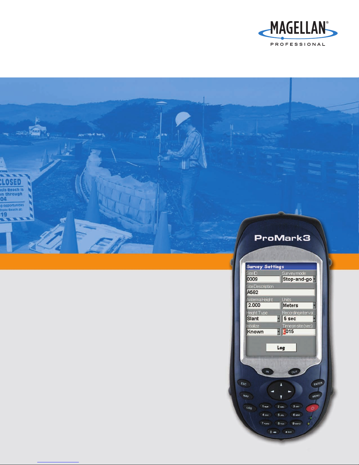
ProMark™3
Breaking New GPS Survey Ground
Page 2
Breaking New GPS Survey Ground
ProMark3
Get More Than Centimeter Accuracy
The leader in L1 GPS surveying introduces ProMark3.
ProMark3 extends the Magellan philosophy of offering an
easy-to-use turnkey system to the surveyor. All the required
hardware and software are included to perform accurate
static, stop & go and kinematic surveys as well as
GIS/mapping projects.
ProMark3 easily beats all the limits optical instruments have
in terms of portability and range, its ease of use and costeffectiveness make it the must-have GNSS system for postprocessed survey.
ProMark3 empowers surveyors to offer both survey and
GIS/mapping ser
investment in equipment and training. With this unique
combination of capabilities, ProMark3 lets users survey more
efficiency and productivity and offers customers valuable
GIS services.
vices to customers without a substantial
Rugged Professional Survey Solution
ProMark3 is designed for surveyors:
■
Shock and water resistant so it performs in the toughest
survey environment
■
Ergonomic features for enhanced comfort
■
Embedded monitoring, diagnostics and quality control tools to
qualify the job before you leave the field
ime by 33%
Reduce Sur
vey T
ProMark3 includes the state-of-the-art Prism™ technology.
Prism reduces the survey data collection occupation time by as
much as 33% and allows r
satellite tracking conditions.
eliable GNSS Sur
1
vey even under poor
ProMark3 is built around a next-generation GNSS engine that
fers two ranges of accuracy:
of
■
Centimeter in post-processing for accurate surveying
■
Sub-meter in real-time for mapping and navigation
oMark3 keeps working even in urban canyons and dense
Pr
foliage using optimized multipath mitigation.
Enjoy the Renowned ProMark Ease of Use
ProMark3 offers a user-friendly interface that capitalizes on the
ProMark2 and MobileMapper™ ease of use. Its integrated
design allows maximum portability, and the simple inter
face,
large color touch screen and full alphanumeric keypad make it
easy to use. ProMark3 allows you to:
■
Learn GPS operation quickly and easily
■
Complete jobs fast, both in the field and in the office
■
Let the intuitive GUI and bundled GNSS Solutions™softwar
e
walk you through seamless data collection and data processing
Breaking the Barriers
oMark3 GNSS sur
Pr
vey system delivers a unique combination
of centimeter-level survey accuracy and sub-meter GIS/mapping
capabilities.
oMark3, Magellan is once again br
ith Pr
W
eaking the bar
riers of
performance, complexity, and cost to bring the newest solutions
to the survey community.
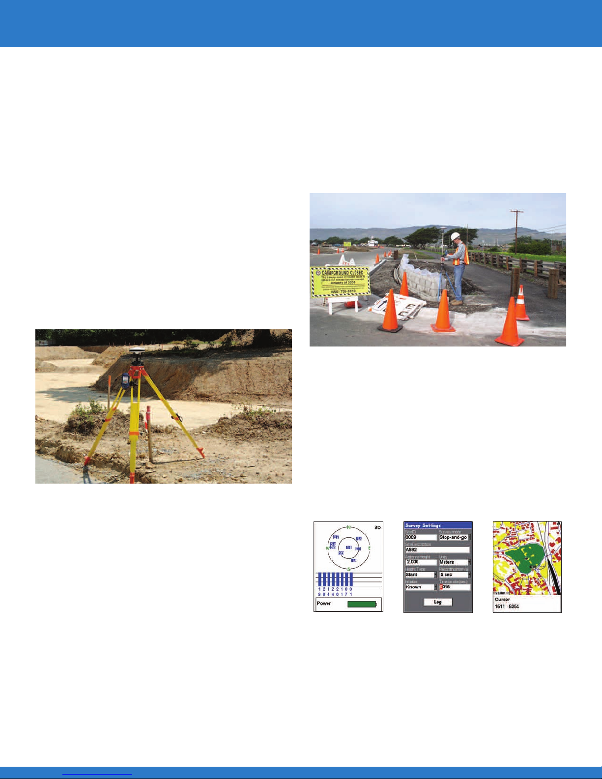
Page 3

Powerful Surveying
Find a Point and Survey It
The ProMark3 system performs powerful surveys, in static, stop
& go or kinematic modes. With centimeter-accurate control and
range far beyond that of an optical instrument, ProMark3 sets a
new standard for ease of use and performance.
Maximum Survey Flexibility
ProMark3’s USB port, Bluetooth®wireless technology, SD-card
and long-life rechargeable battery provide the latest in
expandability and functionality.
The user-interface can be localized into the language of your
choice2 and color background maps can be uploaded from
.SHP, .MIF, .DXF and .CSV files.
ProMark3 can also be used in conjunction with optical
instruments in cases where both are needed.
Locating and surveying hard-to-find points is a snap with the
navigation and data collection capabilities of ProMark3. After
navigating to a point using the unit’s base map, transitioning to
survey mode requires only a single keystroke.
Once set up over a point, the unit prompts the user for
attribute infor
been collected.
mation and indicates when sufficient data has
GNSS Solutions Office Software
Survey Data Processing Made Easy
GNSS Solutions is a compr
ed to successfully pr
the tools r
SBAS survey data. Focusing on simplicity, the software guides
the user thr
quality contr
Accuracy and Reliability
GNSS Solutions includes advanced error detection and quality
analysis tools to ensure accurate and reliable results. Loop
closures, automatic repeat, observation analysis, automatic
control analysis, and least-squares adjustments are integral
components of GNSS Solutions.
equir
ough mission pr
epor
ol, r
ehensive softwar
ocess GPS, GLONASS and
eparation planning, processing,
ting, expor
ting.
e package with all of
simple. Any collection of data can be viewed in dif
through simple drag and drop operations. Importing raster or
vector map for
with land sur
Adapts Easily to User Requirements
GNSS Solutions can be installed by the user in several
languages. Numerous mapping projections and local coordinate
transformations are available to let users create individual report
files that comply with national standards.
mats lets sur
ojects.
vey pr
veyors combine background projects
fer
ms
ent for
Intuitive Handling of Graphical Data
Magellan Professional products present survey data in graphical
and tabular form, making post-processing with GNSS Solutions
Page 4

Integrated Mapping Solution
Expand Your Service Offer with GIS
ProMark3 is also a mobile mapping system combining full GIS
data collection and navigation software. Backed by powerful
office software for easy data display, editing and export,
ProMark3 delivers affordable, sub-meter accurate GIS data.
With ProMark3, surveyors can now perform true GIS
projects and offer customers additional services such as
mapping and asset management.
Turnkey Mapping
Both the field and office software, included with ProMark3,
are specially designed for ease of use so that minimum data
collection and processing training is required. The brilliant,
full-color display brings maps to life in full sunlight, making it
easier to work with unfamiliar GIS data sets.
Accurate GIS Data Collection
ProMark3 delivers sub-meter real-time accuracy using SBAS
or RTCM corrections. Mapping functions include powerful yet
easy-to-use features such as:
MobileMapper Office Software
Connecting Field Assets with Geographic
Information Systems
MobileMapper Office links the ProMark3 receiver to your GIS.
Using this software, users can import GIS data into job files to
be updated in the field. It also provides convenient features
such as:
■
Quick and easy editing and exporting of data. Includes
support for .SHP, .MIF, .DXF and .CSV files
■
Uploading or creation of vector background maps for use in
the field
■
Raster image support
■
Post-processing
■
Point, line and area mapping
■
Area calculation for real-time area determination
■
Offset measurement for all feature types, including point,
line and area
Mapping Made Easy
The software also includes a Feature Library Editor that creates
lists of featur
field. It can even generate the featur
es and attributes for describing GIS assets in the
e libraries automatically by
reading imported .SHP and .MIF files.
oMark3’
Pr
fice is a tur
Of
s mapping features combined with MobileMapper
nkey solution for the operator who wants to cr
eate
or maintain GIS maps or feature in the field.
With ProMark3
mapping is a service
sur
veyors can of
fer without
investing in additional
dedicated GIS equipment.
Page 5

Applications
Survey Applications
With the new Prism technology, ProMark3 allows centimeterlevel static surveys to be performed faster than ever as the
occupation time can be reduced by up to 33%.
Stop & go surveys are simplified with ProMark3. The portability
and the user-friendly interface enable a one-man crew to
perform quick and reliable surveys.
ProMark3 eliminates line-of-sight a one-man survey
requirements and enables survey of larger areas. Survey firms
using the ProMark3 system will see their operational downtime
reduced and will save personnel costs.
1
GIS/Mapping Applications
ProMark3 lets users take any supported GIS file into the field.
Now surveyors can navigate to field infrastructure, map or
update the GIS data and easily transfer the file back to the
office GIS.
Traditional survey customers are using geographical information
more and more. To keep their GIS data live and accurate, cities,
utilities or civil engineering companies need a continuous data
update that surveyors can easily perform with ProMark3.
For kinematic data collection, ProMark3 records data at
different rates, allowing surveyors to match the recorded details
to the speed of the rover. With its 1 Hz recording rate, ProMark3
is an unparalleled productivity tool.
Page 6

ProMark3 Technical Specifications
GNSS Characteristics
■
14 parallel channels
■
L1 C/A code and carrier
■
Integrated real-time WAAS/EGNOS
■
Update rate: 1 Hz
■
Protocol: NMEA0183
■
RTCM SC-104 version 2.1
Accuracy Specifications
3
Static Survey Performance (rms)
■
Horizontal: 0.005 m + 1 ppm
(0.016 ft + 1 ppm)
■
Vertical: 0.01 m + 2 ppm (0.032 ft + 2 ppm)
■
Azimuth: < 1 arc second
■
Observation Time: Ranges from 4 to 40
minutes depending on distance between
ProMark3 receivers and other
environmental factors
1, 3
Kinematic Survey Performance
■
Horizontal: 0.012 m + 2.5 ppm
(0.039 ft + 2.5 ppm)
■
Vertical: 0.015 m + 2.5 ppm
(0.049 ft + 2.5 ppm)
■
Recommended Initializer Bar Occupation:
5 minutes
Real-Time Performance
3
SBAS (WAAS/EGNOS) (rms)
■
Horizontal: <1m (3ft)
DGPS (Beacon or RTCM) (rms)
■
Horizontal: <1m (3ft)
Datalogging Characteristics
Recording Interval
■
1 - 30 seconds
Internal Memory Capacity
■
Up to 72 hours of 10 satellite data @ 1
second interval
Physical Characteristics
Size
■
Unit: 19.5 x 9 x 4.6 cm (7.7 x 4.6 x 1.8 in)
■
Antenna: 19 x 9.6 cm
(7.5 in DIA x 3.8 in H)
Weight
■
Unit: 0.48 kg (1.05 lb) with battery
■
Antenna: 0.45 kg (1.00 lb)
User Interface
■
Full color advanced TFT liquid crystal display
with backlight
■
320 x 240 resolution with 262.144 colors
■
Resistive touch panel
■
■
d with backlight 20 buttons
Keyboar
Audio: built-in speaker
Memory
■
128 MB SDRAM, 128 NAND Flash memory
■
Removable SD Card: up to 1 GB
Interface
■
RS232
■
USB: host and slave
■
luetooth wireless technology
B
– Specification 1.2 compliant
– Point-to-point and point-to-multi-point
– Profiles: serial port, OBEX, dial up
networking
nvironmental Characteristics
E
Receiver
■
Operating Temp: -10°C to 60°C
(14°F to 140°F)
■
Storage Temp: -20°C to 70°C (-4°F to 158°F)
■
Weather: Water-resistant
■
Shock: 1.5 m (4.9 ft) drop on concrete
Antenna
■
Operating Temp: -55°C to 85°C
(-67°F to 185°F)
■
Weather: Waterproof
■
Shock: 2 m (6.6 ft) drop on concrete
Power Characteristics
■
Battery type: 3.7 V Li-Ion, 3900 mAh
■
Battery life: 8 hours (typical operation)
■
External power for extended operation time
Field Software Tools
■
GPS utilities
■
Bluetooth Manager
■
System / Data Back-up / Restore
Receiver Language Support
■
English, French, German, Spanish, Italian,
Portuguese, Finnish, Swedish, Dutch,
Custom language
■
Russian
■
Chinese
2
Accessories
d System Accessories
Standar
■
Clip-on I/O Module with power, USB and
RS232 ports
■
Universal AC adapter
■
Stylus (2)
■
Hand strap
■
ying case
r
Car
■
USB data cable
■
32 MB SD memory card
■
Padded field bag
■
HI measur
ement device
Optional Accessories
■
External Power kit
■
Dual-slot battery charger
■
USCG/IALA Beacon receiver
Emissions Certification
■
Immunity (EN 55022 Class B)
■
Susceptibility (EN 50082-1)
■
FCC and CE certified
ffice Software Suite
O
Survey: GNSS Solutions Software
Key software functions include:
■
Integrated transformation and grid system
computations allow for processing, adjusting,
reporting, and exporting point positions in
user-selected or user-defined systems
■
Pre-defined datums along with user-defined
capabilities using the 7-parameter method of
computing and applying datum
transformation parameters
■
Survey mission planning
■
Automatic vector processing
■
Least-squares network adjustment
■
Data analysis and quality control tools
■
Coordinate transformations
■
Geoid 03
GIS: MobileMapper Office
Key software functions include:
■
Feature Library Editor
■
Background Map Creation
■
Job Creation and Editing
■
Differential Correction
■
GIS Data Display and Editing
■
GIS Import/Export: ESRI .SHP, MapInfo .MIF
and AutoDesk .DXF import/export and
.CSV export
System Requirements
■
Windows®2000 / XP
■
Pentium®233 min
■
64 MB RAM min, 128 MB r
■
200 MB hard disk space required
for installation
1
Prism technology impact varies on satellite conditions and
may not apply at all time in all area in the world.
2
Limitations based on character availability may apply.
Localization is under distributor’s responsibility.
3
Accuracies assume minimum of five satellites, following the
procedures recommended in the product manual. Highmultipath areas, poor satellite geometry, and
periods of high-activity atmospheric conditions will degrade
accuracy. Post-processing with GNSS Solutions Software.
Accuracy and TTFF specifications based on tests conduct
ed in Nantes and Moscow. Tests in different locations
under different conditions may produce
esults.
ent r
fer
dif
ecommended
-
Survey Solutions Contact Information:
In USA +1 408 615 3970 ■Fax +1 408 615 5200
Toll Free (Sales in USA/Canada) 1 800 922 2401
In South America +56 2 273 3214 ■Fax +56 2 273 3187
Email sur
veysales@magellangps.com
In Singapore+65 6235 3678 ■Fax +65 6235 4869
In China +86 10 6566 9866 ■Fax +86 10 6566 0246
Email surveysalesapac@magellangps.com
www.pro.magellanGPS.com
Magellan follows a policy of continuous product improvement; specifications and descriptions are thus subject to change without notice. Please contact Magellan for the latest product information.
©2006 Magellan Navigation, Inc. All rights r
espective holders. Sept 25 P/N XC20103
of their r
ved. ProMark, MobileMapper, Prism and GNSS Solutions are trademarks of Magellan Navigation, Inc.
eser
oduct and brand names ar
All other pr
e trademarks
 Loading...