

Page 1
2009
Product Catalog
www.lowrance.com
A Navico brand – Leader in Marine Electronics
Page 2
2
Introducing
High
Definition
System
Welcome to the new world of functional
advancements in marine electronics.
Lowrance HDS (High-Denition System): the new, advanced series of
multi-function displays that are a revolutionary step forward in shnding and navigation-electronics innovation.
They combine the legendary, best-in-class Lowrance technology, fully
integrated weather and radar solutions and an attractive case design
that is more convenient to install.
Plus, a new easier-to-use operating system simplies access to
frequently used, and the most advanced, features to enhance your
pleasure and success.
Page 3
3
www.lowrance.com
Contents
Lowrance HDS Features 4-7
HDS Fishnders/Chartplotters 8-13
HDS Chartplotters 14-17
High Denition Digital Radar 18-19
Legendary Fishnders 20-22
IceMachine™ 23
VHF Marine Radios 24-27
Networking & Digital Gauges 28-33
Transducers 34-35
Outdoor GPS Navigation 36-39
Cartography 40-41
Specications 42-45
About Navico 46-47
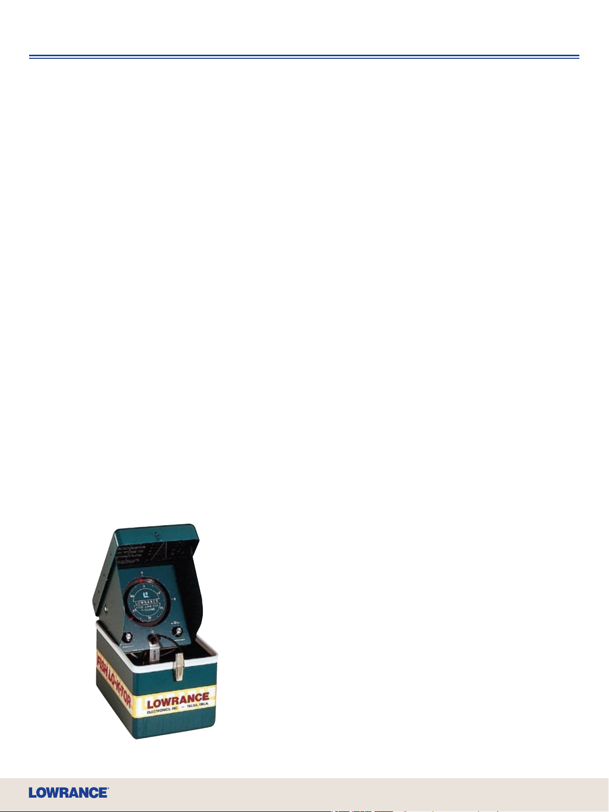
It Started in 1957
That’s when Lowrance introduced the world’s rst
transistorized and portable sportshing sonar – the legendary
Fish Lo-K-Tor, known by delighted anglers everywhere as the
“Little Green Box.” Incredibly innovative for the time and
spawning a whole industry, it was bestowed an Anglers’
Legacy Innovation Award by the American Sportshing
Association in 2008 as one of the top 10 products that
changed the way people sh over the past 75 years.
Lowrance again presents a revolutionary approach in marine
electronics with the introduction of HDS in 2009.
Page 4
4
High
Definition
System
The Most Revolutionary Finders Since The Little Green Box
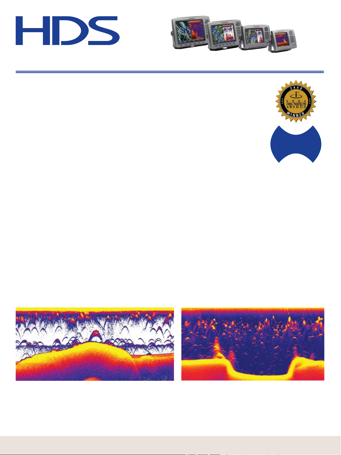
HDS Highest-Denition Broadband Fishnding
Incredible and award-winning, exclusive Broadband Sounder digital technology is
now inside all HDS sonar models for the best Lowrance shnding ever! As the vital
link between the transducer and your HDS display, Broadband is proven to nd
more sh with greater sensitivity, higher denition and more display clarity with
superior target separation in all cover, in thermoclines and in all water conditions.
Less Noise, More Targets
With Lowrance Broadband digital signal processing software, noise goes way down and sensitivity goes way up.
The result: Ultimate target discrimination with incredible high-denition separation of those distinctive Lowrance
“sh arch” targets from structure and other sh!
Crystal-Clear Clarity
With advanced digital ltering, Broadband vastly improves at-a-glance display clarity, sharpens bottom images
and paints a much cleaner picture of targets that others will miss or show poorly.
BUILT-IN
B R O A D B A N D
S O U N D E R
Greater Shallow-Water Coverage
To cover even more water, Broadband automatically adds 83 kHz operation to a Lowrance 200 kHz singlefrequency transducer. At 83 kHz, you get full 120-degrees of wide-angle coverage with greatly enhanced
denition of sh arch targets.
Incredible Deep-Water Performance
Broadband sounding is serious electronics when the hunt is on for sh in any deep water weather condition.
Even at higher boat speeds, Broadband keeps a bottom lock at depth, with exceptional targeting of sh arches
on the bottom, around wrecks and other seabed structure. And when used with a high-power transducer, strong
bottom locks and water column detail reach down thousands of feet!
Expandability at No Extra Cost
For added value, HDS Broadband-equipped models can turn an HDS GPS Chartplotter (or GlobalMap®
chartplotter with yellow ethernet connector) into a powerful combination shnder/chartplotter with complete
sonar graph control when networked by Lowrance Ethernetworks.
Broadband with 83 kHz (shown with white-screen background)
provides wider coverage and enhanced target returns, to more easily
identify suspended sh in thermoclines and near the surface.
Broadband with 200 kHz (shown with blue-screen background)
provides crystal-clear images of shing hotspots -- like this creek
channel with trees at the top of each bank and surrounded by
suspended bait and gamesh.
Page 5
5
www.lowrance.com
Lowrance HDS Features
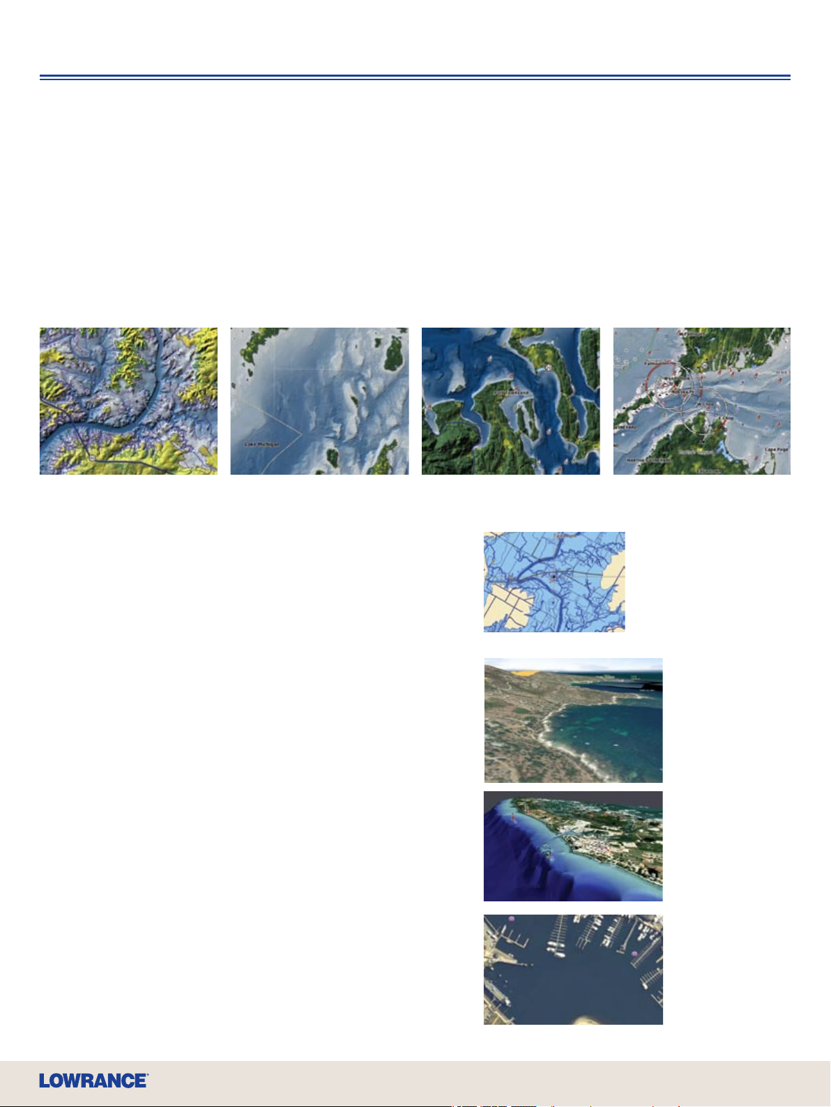
Fantastic High-Denition Mapping
Only Lowrance offers a stunning new world of cartography options that go to greater depths,
and heights, in dimensional GPS navigation reference and guidance.
NEW Insight USA™ – A Charting Revolution in Detail and Resolution
Insight delivers unprecedented inland mapping and coastal charting detail with lightning-fast screen display updates. Amazing contour
shading lends life-like perspectives to bottom structure as well as topography. HDS Insight mapping choices include:
NEW Lake Insight™ U.S. inland mapping (for HDS-5) includes nearly 5,000 freshwater lake maps with life-like perspective of bottom
structure and topography. Coverage includes the Great Lakes and more than 500 Fishing Hot Spots
NEW Nautic Insight™ (for HDS-5) offers a superior like-like view of coastal bottom structure with detailed coastal and offshore depth
contours, plus nav aids, for the entire U.S. coastline.
NEW Insight USA™ (for HDS-7, -8 and -10 models) combines inland and coastal coverage ares of Lake Insight™ and Nautic Insight™.
®
Lakes – a $400 value!
Lake Insight™
Amistad Reservoir, Texas
Lake Insight™
Lake Michigan, Michigan
Nautic Insight™
Puget Sound, Washington
Expanded Basemap Marine Detail
HDS models with Enhanced U.S. Basemap offer the same
geographic coverage area as Insight, with over 100,000
bodies of water and nearly 5,000 enhanced U.S. lakes with
high detail lake shorelines and contours.
HDS Mapping Options Go All-Platinum
Your trusted favorites in Lowrance 2D mapping choices,
like Fishing Hot Spots® PRO and LakeMaster® ProMaps
are fully functional with HDS. Lowrance HDS expands
your world of high-detail, high-denition 3D charting
options with total compatibility for all 2009 (and earlier)
Navionics® chartcards.
Platinum+ and Platinum – Revealing 3D views of bottom structure,
and incredibly detailed satellite imagery, for the ultimate enhancement
to navigation and shing.
HotMaps Platinum – Fantastically detailed 3D lake surveys with
shing points of interest give marked advantages for the serious angler
and tournament competitor.
Exclusive TurboView™ Advantage – This exclusive HDS built-in
graphics engine delivers seamless zooms and 2D-3D chart displays,
real-time 3D map nav data overlay, striking depth views in 2D and 3D,
plus high-speed panning/zooming with detailed aerial views for all
Platinum chartcards, and seamless zoom for Navionics
Plays Navionics
library of Navionics
®
Favorites – HDS is also fully compatible with your
®
Gold, Silver, Classic and HotMaps chartcards.
®
Gold.
Nautic Insight™
Nantucket Sound, Massachusetts
Enhanced
basemap
includes detailed
shoreline and
lake depth
contours
®
Navionics
Platinum+ with
TurboView™
Navionics®
Platinum+ with
Aerial View
Navionics
Platinum+ 3D
View
®
Navionics® chart/mapping compatibilty with free HDS software upgrade in Q1 2009
Page 6
6
High
Definition
System
The Most Revolutionary Finders Since The Little Green Box
HDS Redenes ‘Ease of Use’
Viewing and control have never been easier, nor more user-friendly. From basic operation to
advanced professional functionality, HDS is thoughtfully designed to take you to the next level.
Stylish and Retrot-Ready –
True, HDS sports a more modern design
to enhance any boat helm. Yet, by
design, HDS makes it easy to upgrade
your Lowrance electronics. HDS is
compatible with late-model Lowrance
transducers, plus yellow Ethernetworks
and NMEA 2000
Better to Find Yourself –
With a built-in, high-sensitivity
16-channel GPS+WAAS antenna HDS
is a superior solution for both bracket
mount, and in-dash installs with the.
convenience of front mounting. Plus,
the internal GPS antenna also
networks with NMEA 2000
for data sharing. No external antenna
to place, no mess, no fuss. Just
advanced GPS accuracy with strong
satellite locks and less track plot
wander.
For closed-cabin installs, there’s also a
new and compact LGC-4000 external
GPS+WAAS antenna module option
for HDS with a true, real-time satellite
signal update rate of ve times per
second for incredible location accuracy.
For details, see page 28.
®
network connectors.
LGC-4000
®
systems
Enjoy Our New Menu Selection –
The new, more versatile HDS operating
system presents a new way to view and
select Lowrance features. This new
menu format is both easy to grasp and
thoughtfully functional, so you can y
through keypad functions control with
the greatest of ease and speed.
Screen Star –
In the easy-to-view category, HDS really
shines. New SolarMAX™ PLUS color
displays render fantastic detail in
sunlight, with the best wide-angle
viewing ever achieved. In fact, most now
deliver nearly twice the brilliance with
signicantly-reduced power draw than
before! Plus, super-white LED
backlighting has zero-dim for eyesoothing night vision protection.
A Touch Better –
For even easier and quicker control,
HDS-8, -8m, -10 and -10m models
feature a unique new FlyWheel™ scroll
dial, as well as a bank of soft command
keys for the fastest access to functions.
So, you spend less time operating and
more time shing.
NEW!
2-Y e ar
Limited Warranty
New 2-year Protection –
Lowrance also warrants that buying
HDS will put your mind at ease. Each
now come with a new, expanded 2-year
limited warranty, protecting you from
defects in materials and workmanship
under normal use for a full 24 months
after purchase. At no extra cost.
Optional two-year extended warranty
also available for purchase.
Page 7
7
www.lowrance.com
HDS Newly-Dened Expandability Options
Lowrance HDS for 2009 presents a wider range of advanced accessory
options to enhance your on-the-water experience, safety and enjoyment.
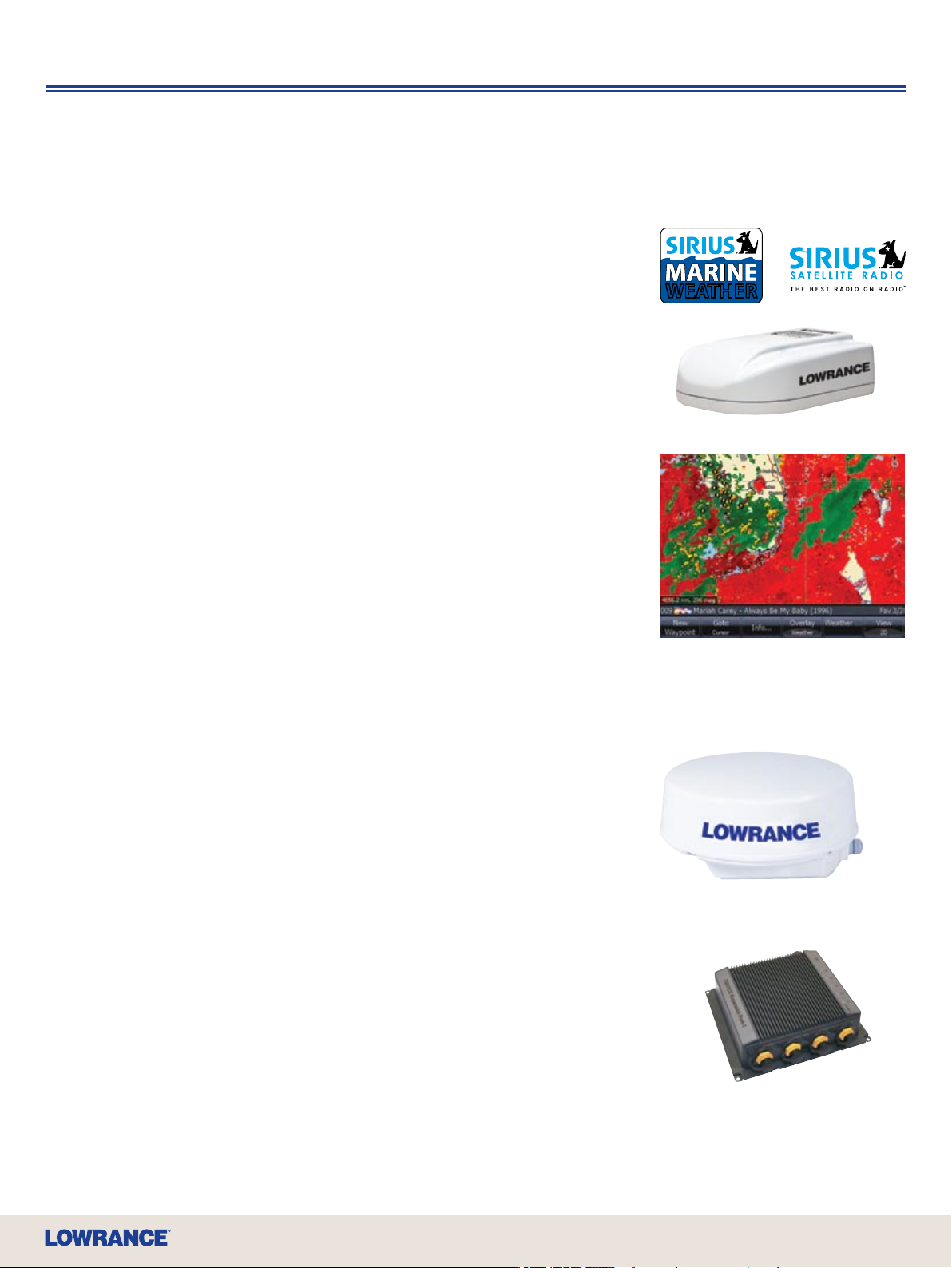
High-Denition Weather – Now Adds Inland
Choice to Standard Offshore Coverage!
New LWX-1 SIRIUS® Satellite Weather/Radio Smart Antenna
Lowrance presents two industry rsts with HDS chartplotters: SIRIUS® satellite high-res
NOWRad
module bundle, AND the rst SIRIUS
… in two special SIRIUS
This compact weatherproof antenna is easy to mount, and provides weather display output to one
or more HDS units via Ethernetworks. Plus a standard 3.5 mm stereo jack easily interfaces with
onboard sound systems when you include radio with your SIRIUS
music and sports including NFL, NASCAR and college football broadcasts.
SIRIUS
• Weather radar and lightning with full 2 km (1.2 mile) resolution
• 80 nm (92 mile) lightning and radial weather display to 12 nm (13 mile) limit from coasts
• Tabular weather feed with 5-day forecast display
SIRIUS
• Cross-country weather radar and lightning with full 2 km (1.2 mile) resolution
• Sea-surface temperature with higher resolution
• Tropical storm and storm cell tracks
• Four-day forecast of surface pressure, wave height, wave period and direction
• Tabular weather feed with 5 day forecast
• And more
See page 30 for more details.
®
weather radar and radio services via an affordable and integrated smart antenna/
®
U.S. subscription packages!
®
Inland Weather Service Package:
®
Coastal/Offshore Weather Service Package:
®
Inland weather service … in addition to Coastal coverage
®
subscription for stereo-quality
Lowrance HDS Features
WEATHERWEATHER
LWX-1
SIRIUS NOWRad® animated coastal
weather radar
High-Denition Digital Radar Choices
LRA-1800 2 kW and LRA-2400 4 kW Radomes
Two choices in Lowrance high-performance digital radar for optimal safety in poor weather or
low-light conditions, with added chart overlay feature, are now easily networked for HDS displays
via Ethernetworks. See page 18 for more details.
Advanced Networking
Ethernetworks NEP-1 Expansion Port
All HDS models come fully ethernet-ready to share high-speed, high-bandwidth data among all HDS
displays on the boat, including sonar graphs, SIRIUS
data distribution, there’s an optional ethernet expansion port. See page 31 for more details.
Full NMEA 2000® Networking
HDS comes with full connectivity for the advanced NMEA standard in boat systems data sharing,
backed by the most extensive and affordable selection of smart sensors for systems monitoring,
including engine and fuel ow for optimum operating economies. See page 28 for more details.
®
weather/radio and radar. For added growth and
LRA-1800
LRA-2400
NE P-1
Page 8
High
8
Definition
System
The Most Revolutionary Finders Since The Little Green Box
Fishnders/GPS Chartplotters
Fantastic HDS Features
• Built-in Broadband Sounder
• Internal 16-channel GPS+WAAS Antenna
• New, Brighter SolarMAX™ PLUS Display
• Built-in High-Denition Insight Mapping
Options
• Largest Selection of Chartcard Options
Including Navionics® Platinum+ with
TurboView™
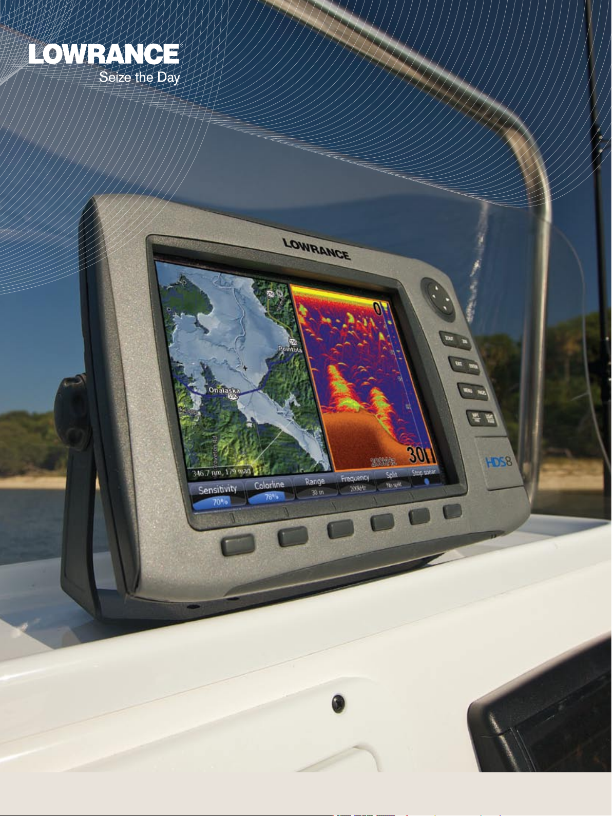
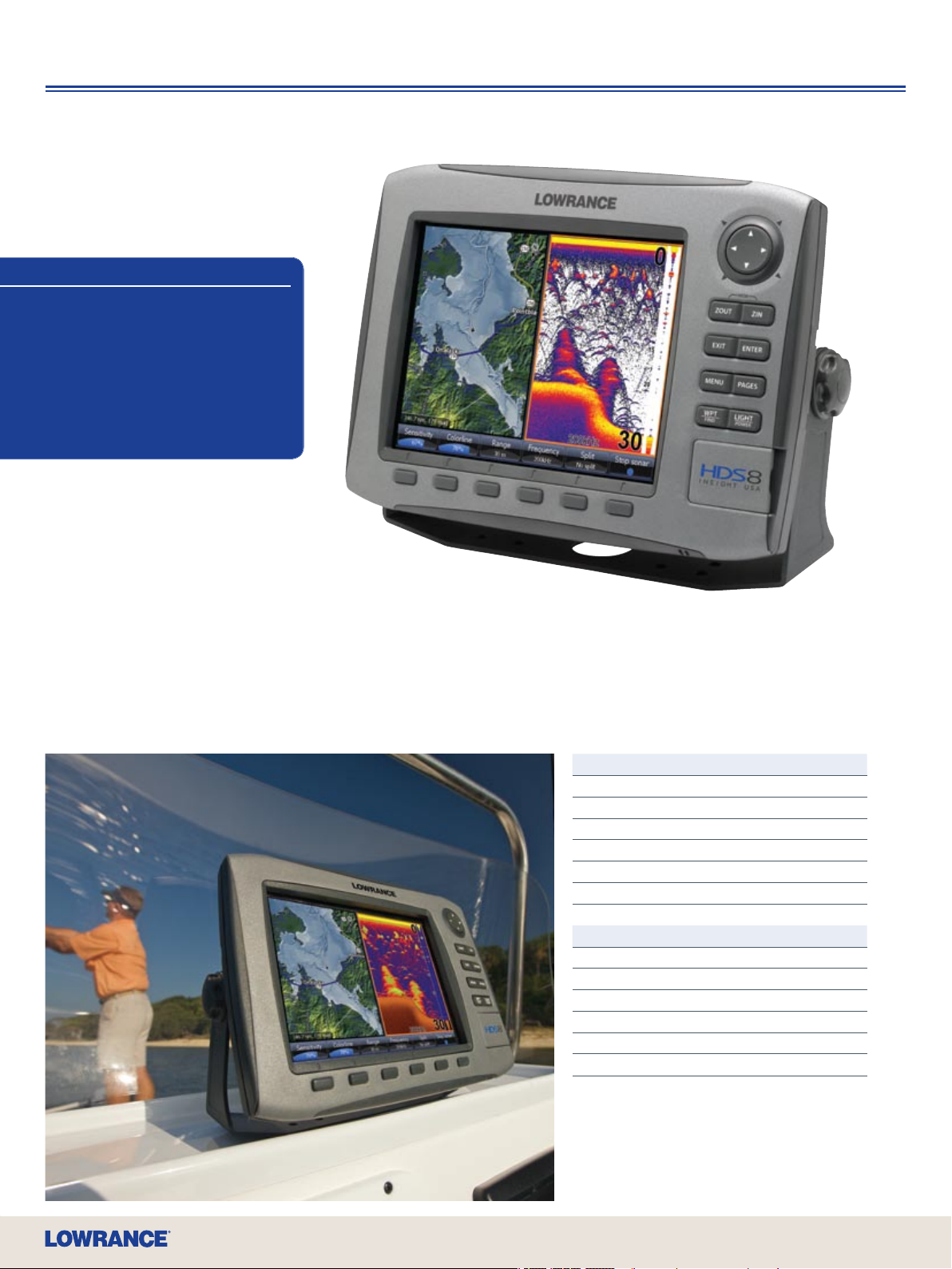
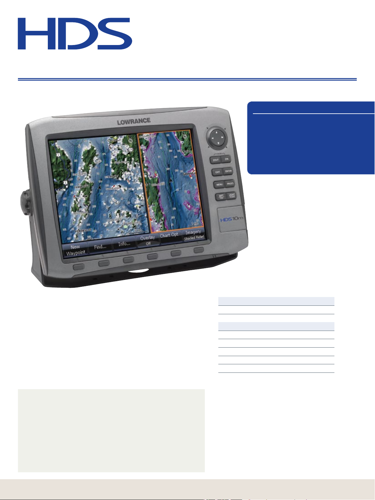
NEW HDS-10 Fishnder/GPS Chartplotter
The nest of new Lowrance shnding and GPS navigation technologies with
massive, high-denition 10.4”/26.4 cm Super VGA color viewing. The new,
brighter SolarMAX™ PLUS display renders brilliant detail in sunlight with the
best wide-angle viewing available, while advanced pure-white LED screen/
keypad backlighting fully adjusts to zero-dim for night viewing. The unique new
FlyWheel™ dial and command soft keys give you easier and quicker control of
Broadband Sounder shnding and satellite navigation precision via the built-in
16-channel GPS+WAAS antenna. HDS built-in cartography choices include
Enhanced U.S. Basemap, or the amazing, life-like and new Insight USA™ with
combined Inland and Coastal coverage. Plus, HDS is fully compatible with all
Navionics
two high-speed SD card slots. Fully ready to build your complete stand-alone or
networked onboard system.
®
chartcards, including Platinum+, Platinum, Platinum HotMaps, with
Model Part
HDS-10
U.S. Basemap, no transducer 140-40
U.S. Basemap, with 83/200 kHz transducer 140 -0 0
Insight USA™, no transducer 14 0- 41
Insight USA™, with 83/200 kHz transducer 14 0-13
Insight USA™, with 50/200 kHz transducer 140 -0 2
Build Your Own System Options Page
LWX-1 SIRIUS
NMEA 2000
HD Digital Radar 18
Transducers, up to 1 kW 34
Ethernetworks 31
VHF Marine DSC radios 24
®
Weather/Radio 30
®
& Fuel Management 28
Page 9
• SIRIUS® Satellite Weather and Stereo-
9
www.lowrance.com
Quality Radio Capability
®
• Ethernetworks and NMEA 2000
Performance Networking Options
• Expanded New 2-Year Warranty
Fishnders/GPS Chartplotters
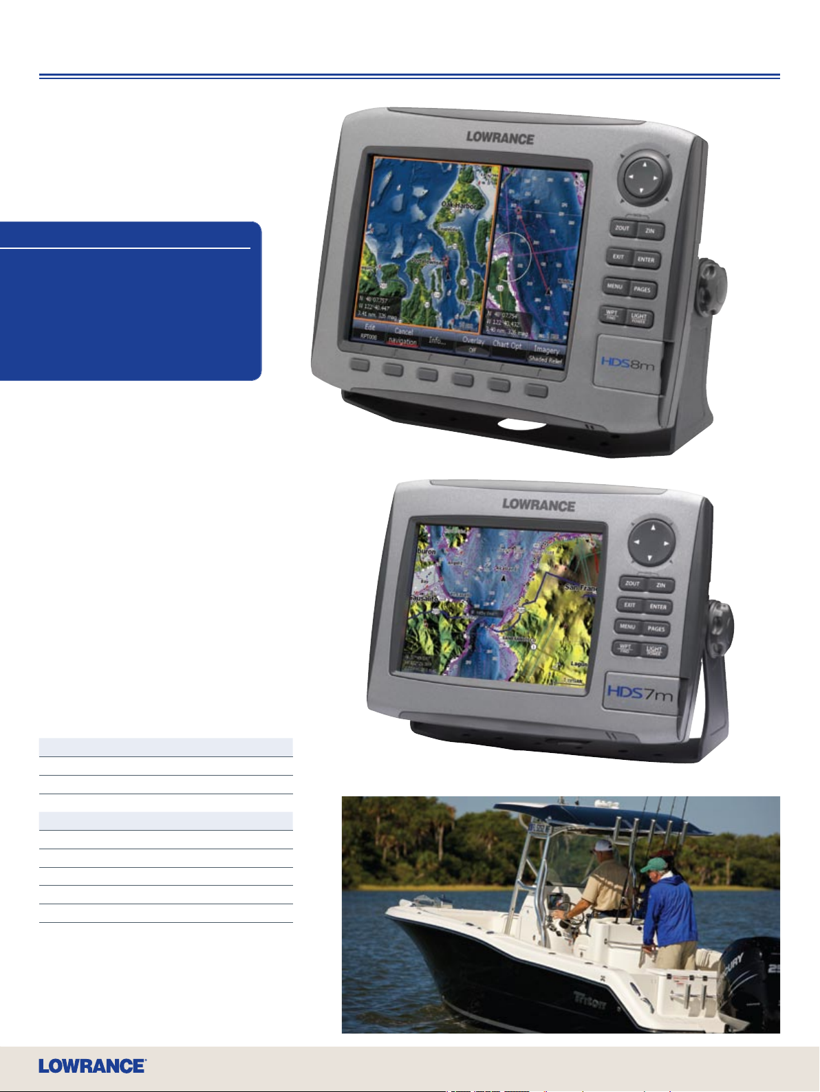
NEW HDS-8 Fishnder/GPS Chartplotter
An easy t with an easy-to-see large display, this HDS delivers high-denition,
Super VGA color brilliance and clarity in an award-winning, right-sized
8.4”/21.3 cm display package. Plus, it offers all the same advanced Lowrance
HDS sounder and navigation technologies and features of the HDS-10, while it
is likewise fully ready to build a complete onboard system.
Model Part
HDS-8
U.S. Basemap, no transducer 140 -3 8
U.S. Basemap, with 83/200 kHz transducer 140 -0 9
Insight USA™, no transducer 140 -3 9
Insight USA™, with 83/200 kHz transducer 140 -0 7
Insight USA™, with 50/200 kHz transducer 140 -0 6
Build Your Own System Options Page
LWX-1 SIRIUS
NMEA 2000
HD Digital Radar 18
Transducers, up to 1 kW 34
Ethernetworks 31
VHF Marine DSC radios 24
®
Weather/Radio 30
®
& Fuel Management 28
Page 10
10
High
Definition
System
The Most Revolutionary Finders Since The Little Green Box
Fishnders/GPS Chartplotters
Fantastic HDS Features
• Built-in Broadband Sounder
• Internal 16-channel GPS+WAAS Antenna
• Brilliant, New SolarMAX™ PLUS Display
• Built-in High-Denition Insight Mapping
Options
• Largest Selection of Chartcard Options
Including Navionics® Platinum+ with
TurboView™
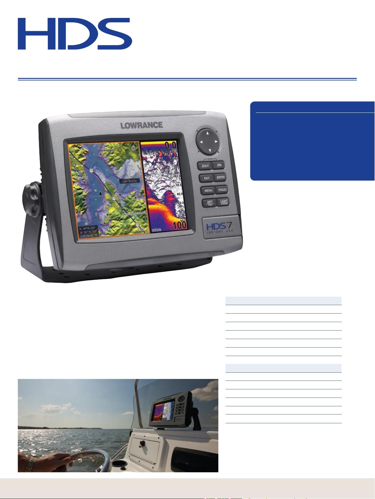
NEW HDS-7 Fishnder/GPS Chartplotter
This large-but-compact solution with 6.4”/16.3 cm full VGA color viewing that
renders astounding shnder and navigation details. It also includes the new,
brighter SolarMAX™ PLUS bright-sunlight/wide-angle display with pure-white LED
screen/keypad backlighting that fully adjusts to zero-dim for night vision. HDS-7
also includes the same for the built-in Broadband high-denition shnder
technology and the high-sensitivity 16-channel GPS+WAAS antenna. HDS built-in
cartography choices include Enhanced U.S. Basemap, or the amazing, life-like and
new Insight USA™ with combined Inland and Coastal coverage. Fully compatible
with all Navionics
with one high-speed SD card slot. Fully ready to build your complete stand-alone or
networked onboard system.
®
chartcards, including Platinum+, Platinum, Platinum HotMaps,
Model Part
HDS -7
U.S. Basemap, no transducer 140-34
U.S. Basemap, with 83/200 kHz transducer 140 -0 5
Insight USA™, no transducer 140 -3 6
Insight USA™, with 83/200 kHz transducer 14 0-12
Insight USA™, with 50/200 kHz transducer 140 -14
Build Your Own System Options Page
LWX-1 SIRIUS
NMEA 2000
HD Digital Radar 18
Transducers, up to 1 kW 34
Ethernetworks 31
VHF Marine DSC radios 24
®
Weather/Radio 30
®
& Fuel Management 28
Page 11
• SIRIUS® Satellite Weather and Stereo-
11
www.lowrance.com
Quality Radio Capability
• Ethernetworks and NMEA 2000®
Performance Networking Options
• Expanded New 2-Year Warranty
Fishnders/GPS Chartplotters
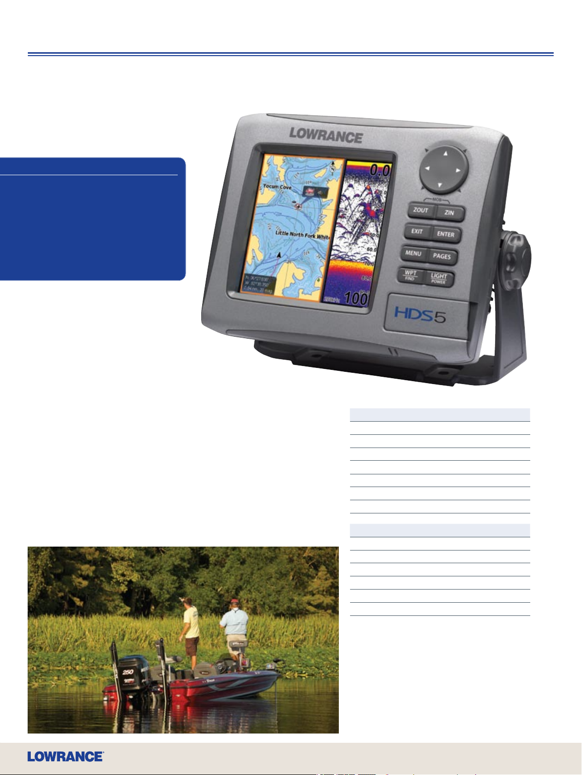
NEW HDS-5 Fishnder/GPS Chartplotter
Presenting big-color denition and multifunction performance in a popular spacesaving design. Viewing performance is exceptionally enhanced with its exclusive,
high-resolution 5”/12.7 cm 256-color SolarMAX™ PLUS daylight display with
adjustable screen and keypad backlighting. Of course, Broadband high-denition
sonar and ultra-precision 16-channel GPS+WAAS antenna are inside. Along with
fantastic built-in lake mapping of the Enhanced U.S. Basemap, you also get a
choice of incredible, built-in high-denition Lowrance Insight cartography with your
model selection: Lake Insight™ for U.S. inland and Great Lakes; and Nautic Insight™
coverage for detailed U.S. coastal waters coverage. The HDS-5 also uses all
Navionics
high-speed SD card slot. Like all HDS models, it’s ready to build your complete
stand-alone or networked onboard system.
®
chartcards, including Platinum+, Platinum, Platinum HotMaps, with one
Model Part
HDS-5
U.S. Basemap, no transducer 140 -3 2
U.S. Basemap, with 83/200 kHz transducer 140 -21
Lake Insight™, no transducer 140 -3 0
Lake Insight™, with 83/200 kHz transducer 14 0-19
Nautic Insight™, no transducer 140 -31
Nautic Insight™, with 50/200 kHz transducer 140 -2 0
Build Your Own System Options Page
LWX-1 SIRIUS
NMEA 2000
HD Digital Radar 18
Transducers, up to 1 kW 34
Ethernetworks 31
VHF Marine DSC radios 24
®
Weather/Radio 30
®
& Fuel Management 28
Page 12
High
Definition
System
The Most Revolutionary Finders Since The Little Green Box
Multifunction Fishnder
HDS Fishnder Features
• Built-in Broadband Sounder
• Brilliant, New SolarMAX™ PLUS Display
• Ethernetworks and NMEA 2000®
Performance Networking Options
• Expanded New 2-Year Warranty
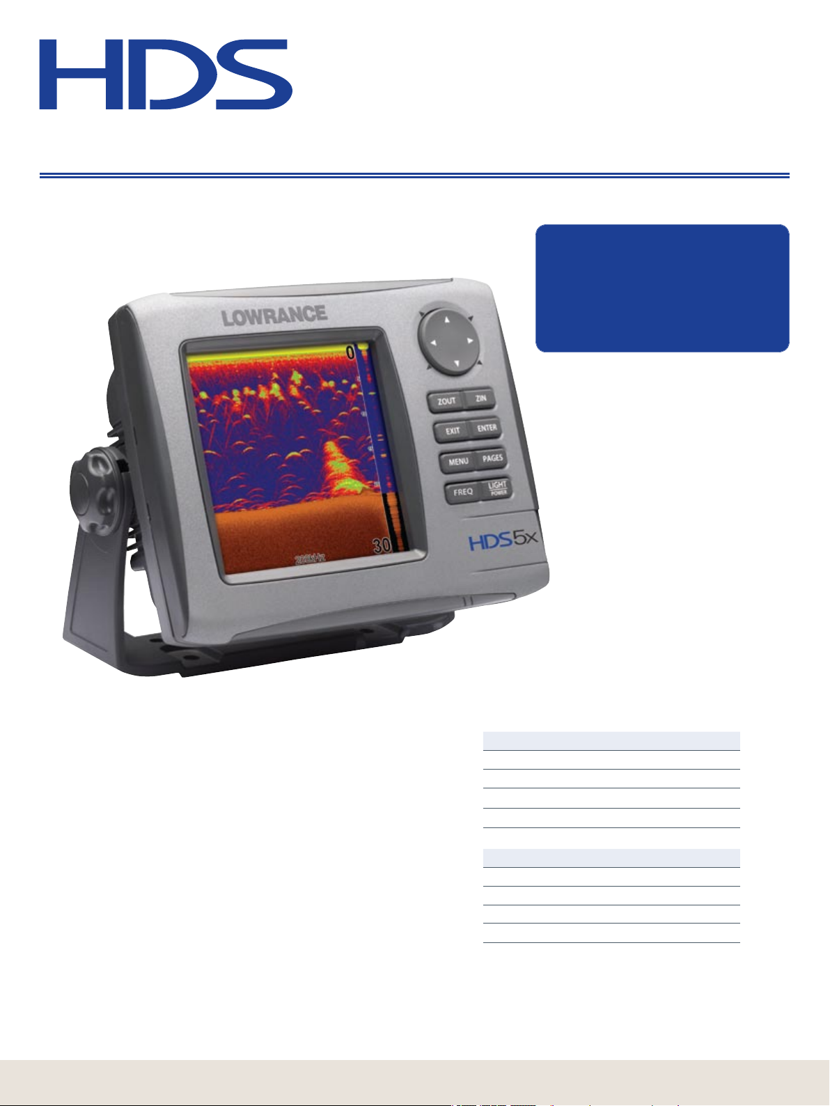
NEW HDS-5x
The legendary Lowrance X-series lives on in this next-generation
advancement in shnding for the serious and professional angler. Its
exceptionally enhanced features and performance are precisely
revealed on high-denition 5”/12.7 cm 256-color SolarMAX™ PLUS
display with adjustable screen and keypad backlighting. Best of all,
Lowrance Broadband Sounder is now built in. So you can nd more sh
with greater sensitivity, higher denition, more display clarity, much less
clutter and the best separation of sh from cover ever achieved by
Lowrance.
Plus, you can quickly and easily save waypoints using the HDS-5x when
networked with any HDS chartplotter or multifunction unit.
12
Model Part
HDS-5x
With 83/200 kHz transducer 140 -27
With 50/200 kHz transducer 140 -28
No transducer 140-29
Optional Accessories Page
Transducers, up to 1 kW 34
NMEA 2000
Ethernetworks 31
VHF Marine DSC radios 24
®
& Fuel Management 28
Page 13
www.lowrance.com
13
Page 14
14
High
Definition
System
The Most Revolutionary Finders Since The Little Green Box
GPS Chartplotters
HDS Chartplotter Features
• Internal 16-channel GPS+WAAS
Antenna
• New, Brighter SolarMAX™ PLUS Display
• Built-in High-Denition Insight Mapping
• Largest Selection of Chartcard Options
Including Navionics® Platinum+ with
TurboView™
NEW HDS-10m Multifunction GPS Chartplotter
Lowrance presents a new dimension in multifunction chartplotters with
large-scale, high-denition 10.4”/26.4 cm Super VGA color viewing. The
new SolarMAX™ PLUS display renders brilliant detail in sunlight with the
best wide-angle viewing available, with advanced pure-white LED screen/
keypad backlighting. A unique new FlyWheel™ dial and command soft keys
give you control with the greatest of ease and speed, and to precisely
guide your way, a new super-sensitive 16-channel GPS+WAAS antenna is
built right in. Also inside is the amazing, life-like and exclusive Insight
USA™ cartography to enhance your on-water navigation for both Inland
lakes and Coastal waters. Plus, this HDS is now fully compatible with all
Navionics
with two high-speed SD card slots.
• SIRIUS
• High-Denition HD Digital Radar with chart overlay
• Ethernetworks high-speed network sharing of sonar, weather and radar
• NMEA 2000
• Fishnder graphs with full functions control when networked with any
®
chartcards, including Platinum+, Platinum, Platinum HotMaps,
Advanced Networking & Expandability on All HDS Chartplotters
For building an onboard system, HDS provides truly advanced denition in
multi-tasking compatibilities.
®
real-time weather, plus unique Inland and Offshore SIRIUS®
subscription choices
®
connectivity for single- or multi-station boat and engine
systems monitoring
HDS sounder
Model Part
HDS-10m with Insight USA™ 14 0-15
Build Your Own System Options Page
LWX-1 SIRIUS
NMEA 2000
HD Digital Radar 18
Ethernetworks 31
VHF Marine DSC radios 24
®
Weather/Radio 30
®
& Fuel Management 28
Page 15
• SIRIUS® Satellite Weather and Stereo-
15
www.lowrance.com
Quality Radio Capability
®
• Ethernetworks and NMEA 2000
Performance Networking Options,
including Broadband Sounder
• Expanded New 2-Year Warranty
GPS Chartplotters
NEW HDS-8m Multifunction
GPS Chartplotter
All the same features of the HDS-10 in an
award-winning, right-sized package, featuring
high-denition, Super VGA color brilliance and
clarity in a 8.4”/21.3 cm SolarMAX™ PLUS display.
NEW HDS-7m Multifunction
GPS Chartplotter
Enjoy big performance and color detail in this largebut-compact system with a 6.4”/16.3 cm full VGA color
display, with the sunlight and wide-angle viewability of
the new SolarMAX™ PLUS screen technologies. With
rocker arrow keys and single keypad and SD card slot.
Model Part
HDS-8m with Insight USA™ 14 0-17
HDS-7m with Insight USA™ 140 -16
Build Your Own System Options Page
LWX-1 SIRIUS
NMEA 2000
HD Digital Radar 18
Ethernetworks 31
VHF Marine DSC radios 24
®
Weather/Radio 30
®
& Fuel Management 28
Page 16

GPS Chartplotters
16
HDS-5m Chartplotter Features
• Internal 16-channel GPS+WAAS
Antenna
• Brilliant, New SolarMAX™ PLUS Display
• Built-in High-Denition Insight Mapping
• Largest Selection of Chartcard Options
Including Navionics
®
Platinum+ with
TurboView™
• SIRIUS
®
Satellite Weather and Stereo-
Quality Radio Capability
®
• Ethernetworks and NMEA 2000
Performance Networking Options,
including Broadband Sounder
• Expanded New 2-Year Warranty
NEW HDS-5m Multifunction GPS Chartplotter
This excellent space-saving choice in the new HDS line of performance
multifunction chartplotters is the ideal choice for installation on smaller
boats. Its exclusive, high-resolution 5”/12.7 cm 256-color SolarMAX™
PLUS display with adjustable backlighting makes it a viewing wonder, day
or night. To precisely nd your way, a new high-sensitivity 16-channel
GPS+WAAS antenna is built-in. The amazing new Nautic Insight™
cartography, with life-like views of underwater topography, is also built in
to enhance boating on U.S. coastal waters. Plus, this HDS is now fully
compatible with all Navionics
HotMaps – with one high-speed SD card slot.
Advanced Networking & Expandability on All HDS Chartplotters
For building an onboard system, HDS provides truly advanced denition in
multi-tasking compatibilities.
• SIRIUS
®
real time weather, plus unique Inland and Offshore SIRIUS®
subscription choices
• High Denition HD Digital Radar with chart overlay
• Ethernetworks high-speed network sharing of sonar, weather and radar
• NMEA 2000
®
connectivity for single- or multi-station boat and engine
systems monitoring
• Fishnder graphs with full functions control when networked with any
HDS sounder
®
chartcards – Platinum+, Platinum, Platinum
Model Part
HDS-5m with Nautic Insight™ 140 -2 3
Build Your Own System Options Page
LWX-1 SIRIUS
NMEA 2000
HD Digital Radar 18
Ethernetworks 31
VHF Marine DSC radios 24
®
Weather/Radio 30
®
& Fuel Management 28
Page 17

HDS-5 Baja Chartplotter Features
17
www.lowrance.com
• Internal 16-channel GPS+WAAS
Antenna
• Brilliant, New SolarMAX™ PLUS Display
• Built-in Enhanced U.S. Basemap
• Largest Selection of Chartcard Options
®
• Ethernetworks and NMEA 2000
Performance Networking Options
• Expanded New 2-Year Warranty
GPS Chartplotters
NEW HDS-5 Baja Off-Road
GPS Chartplotter
This specially-ruggedized edition makes a perfect t
for tighter, off-highway vehicle interiors. Compatible
with the new LGC-4000 external GPS antenna and
high-detail Lowrance FreedomMaps™ EX topo
mapping options.
Model Part
HDS-5m with U. S. Basemap 14 0- 26
LGC-4000 Baja external GPS+WAAS antenna 125 -31
Build Your Own System Options Page
LWX-1 SIRIUS
NMEA 2000
Ethernetworks 31
FreedomMaps™ 41
®
Weather/Radio 30
®
& Fuel Management 28
Page 18

High-Denition Digital Radar
Advanced Lowrance digital signal processing in high-denition radome choices for
HDS. Fast, detailed radar detection of even small and distant targets with superb
accuracy in dark, fog and rain alike. Compact, dependable and high-performance,
both network with Ethernetworks for onboard radar display sharing.
Digital Radome Features
Radar/Chart Overlay.
Interfaces charts and radar detail in a
single, detail-rich display when coupled
with an optional, compatible NMEA
®
2000
heading sensor.
Clearest Viewing.
Automatic Tune, Gain and Sea Clutter
adjustment.
Smart STC.
Digital Sensitivity Time Control curves
reject clutter with setting of return
strength/distance thresholds.
Color Recognition.
Color palette choices for improved target
distinction based on viewing conditions.
LRA-1800 Radome
• 2 kW, 18”/46 cm scanner w/2 kW processor
• 5.2º horizontal beamwidth, 25º vertical
beamwidth
• Up to 24 nm range
LRA-1800
NEW LRA-2400 Radome
• 4 kW, 24”/61 cm scanner w/2 kW processor
• 4º horizontal beamwidth, 25º vertical
beamwidth
• Up to 48 nm range
LRA-2400
HDS high-denition radar display. Radar chart overlay display.
Simrad NMEA 2 000® heading sensor options to activate radar/chart overlay display.
FC40 Fluxgate Compass, includes 5M SimNet NMEA 2000
FC42 Rate Gyro Fluxgate Compass, includes 5M SimNet NMEA 2000® cable 2 209 0195
Required for both compasses above:
SimNet NMEA 2000
Yellow SimNet Joiner without Terminator 441 722 60
Lowrance N2K-T-RD NMEA 2000
Radar range depends on fog, rain and other atmospheric conditions.
18
®
cable to Micro-C male 24005729
®
T-connector 119 - 79
®
cable 22 09018 7
Model Part
LRA-1800 for HDS 102-3 8
LRA-2400 for HDS 102-3 9
Page 19

www.lowrance.com
19
Page 20

Legendary Fishnders
Find sh like a pro when you have a real performance edge
with these legendary Lowrance shnders.
Packed with Exclusive and Legendary Lowrance Fish-Finding Features:
• Astounding LCD screen visibility in the brightest sunlight with monochrome FSTN and daylight color TFT displays
• Super-sensitivity receiver design enhances sh target acquisition and separation
• High-speed 200kHz Skimmer
• GRAYLINE
• FishReveal™ enhanced display feature exposes sh targets hidden in cover and clutter (monochrome models)
• Adjustable Ping Speed with HyperScroll™ for high-speed sounding
• FlashGraf™ combines scrolling sonar graph with LCD asher for two ways of nding sh in one screen display
• FasTrack™ vertical bar asher feature shows real-time returns and strength of echos
• ASP™ Advanced Signal Processing features automatic sensitivity adjustments for the best, clutter-free picture possible
• Full one-year warranty
®
or COLORLINE™ feature vastly improves target denition and denes bottom composition
®
transducer with built-in temp sensor and up to 60˚ of wide-scan sh detection
Color Compacts
X67c Fishnder with New, Brighter
Color Viewing
Enjoy dazzling 256-color shnder performance with
incredible visibility in sunlight, now enhanced with a
brighter screen, at an attractive price!
• New 3.5”/8.9 cm diag. 320Vx240H pixel, active matrix
TFT display for exceptional sonar detail is now even more
visible in sunlight
• White LED backlit screen and keypad
• 800W peak-to-peak power/100W RMS, depths to
600’/183 m
M68c s/m a p with New, Brighter
Color Viewing
A favorite for smaller spaces, packed with Lowrance
precision color shnding and GPS navigation features –
now with a newly enhanced brighter screen – packed in
compact performance package.
• New 3.5”/8.9 cm diag. 320Vx240H pixel, active matrix
TFT display for exceptional sonar detail is now even more
visible in sunlight
• White LED backlit screen and keypad
• 800W peak-to-peak power/100W RMS, depths to
600’/183 m
• Precision GPS+WAAS receiver with internal antenna
• Built-in Lowrance cartography of U.S. lakes, rivers and
coastal waters with nav aids, plus major highways/cities
• Saves up to 1,000 waypoints to mark sh spots with a
choice of 42 icons
• Saves up to 100 retraceable plot trails
M68c s/m a p Map Deep Water
Features special Skimmer® deep water transducer with
temp sensor for deeper salt water or downrigger tracking
to depths of 800’/244 m.
20
Page 21
Legendary Fishnders
Network with NMEA 2000
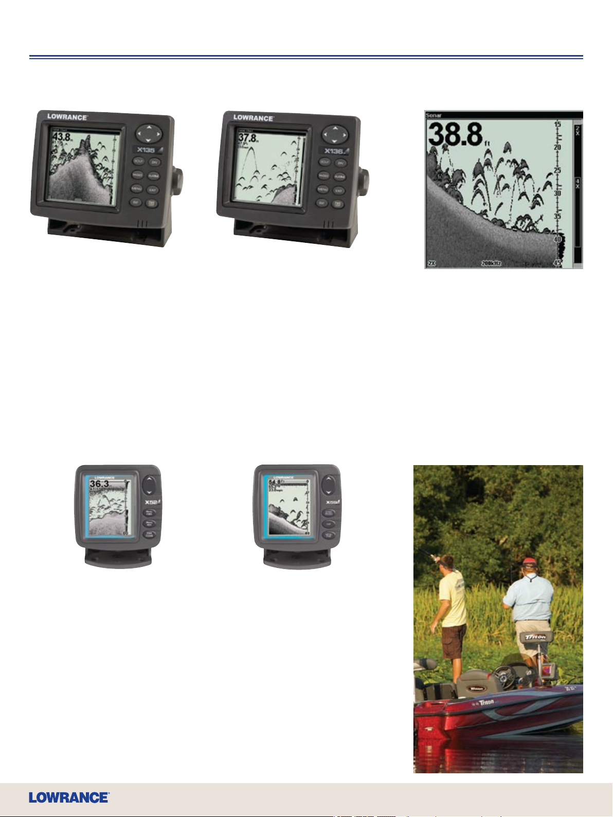
X135 200 kHz Fishnder
The most popular and powerful,
high-resolution Lowrance grayscale
shnder ever!
• High-detail 5”/12.7 cm diag. Film
SuperTwist display with 16-level
grayscale denition and sharp
480x480 pixel resolution is perfectly
sunlight-readable
• Advanced white LED backlit screen
and keypad
• 4,000W peak-to-peak power/500W
RMS, depths to 1,000’/305 m
• NMEA 2000
®
network connectivity
X136 d f 50/200 kHz Fishnder
The dual-frequency coastal/Great Lakes model of the
X135 for deeper salt water or downrigger tracking.
• High-detail 5”/12.7 cm diag. Film SuperTwist display
with 16-level grayscale denition and sharp 480x480
pixel resolution is perfectly sunlight-readable
• Advanced white LED backlit screen and keypad
• 4,000W peak-to-peak power/500W RMS, depths to
2,500’/762 m @ 50 kHz
• High-speed dual-frequency 50/200kHz Skimmer
transducer with built-in temp sensor
• Speed/distance sensor aids in precision trolling
• NMEA 2000
®
network connectivity
®
®
Grayline
(Colorline™ on color
models) helps separate sh and
important structure from the actual
bottom. Also, the width of the lighter
band distinguishes between hard
and soft bottoms.
®
X52 200 kHz Fishnder
A perennial best-buy favorite in a true
shnder performer that’s nicely sized
and nicely priced to match.
• High-contrast 4”/10.2 cm diag. Film
SuperTwist display has 16-level
grayscale denition with 240Vx160H
pixel resolution and superior viewing in
direct sunlight
• Backlit screen and keypad
• 1,500W peak-to-peak power/188W
RMS, depths to 800’/274 m
• NMEA 2000
®
network connectivity
X59 d f 50/200 kHz Fishnder
The dual-frequency coastal model of the
X52 for deeper salt water or downrigger
tracking.
• High-contrast 4”/10.2 cm diag. Film
SuperTwist display has 16-level grayscale
denition with 240Vx160H pixel
resolution and superior viewing in direct
sunlight
• Backlit screen and keypad
• 2,400W peak-to-peak power/300W RMS,
depths to 1,500’/457 m @ 50 kHz
• High-speed dual-frequency 50/200 kHz
Skimmer
sensor
• NMEA 2000
®
transducer with built-in temp
®
network connectivity
www.lowrance.com
21
Page 22

Legendary Fishnders
Monochrome Marvels
X125 200 kHz Fishnder
Uncompromising Lowrance features in a
performance package for shing
success.
• High-detail 5”/12.7 cm diag. Film
SuperTwist display with 16-level
grayscale denition and sharp
480x480 pixel resolution is perfectly
sunlight-readable
• Amber LED backlit screen and keypad
• 2,400W peak-to-peak power/300W
RMS, depths to 900’/274 m
X50 DS 83/200 kHz Fishnder
A versatile and innovative shnder with
dual-search 83/200 kHz sounding for
excellent shallow and deep water sh target
marking.
• Dual-search Skimmer
built-in temp sensor and up to 120º of
wide-coverage sh detection at 83 kHz
• High-contrast 4”/10.2 cm diag. Film
SuperTwist display with 4-level grayscale,
240Vx160H pixel resolution and superior
viewing in direct sunlight
• Screen backlighting
• 1,500W peak-to-peak/188W RMS depths
to 1,000’/305 m
®
transducer with
X96 200 kHz Fishnder
The popular champion-grade choice with
fullsize picture and sonar performance
features at a fantastic price.
• High-contrast 5”/12.7 cm diag. Film
SuperTwist display has 16-level grayscale
denition with 320x320 pixel resolution
and superior viewing in direct sunlight
• Incandescent backlit screen and keypad
• 1,500W peak-to-peak power/188W RMS,
depths to 800’/244 m
Model Part
X6 7c 11 0- 5 0
X67c without transducer 110 - 51
M68c s/map
M68c s/map without transducer
M68c s/map Deep Water
X50 ds
X52 110 - 6 1
X59 df
X96 110-76
X125 117- 0 7
X135 117- 0 1
X135 without transducer 117- 13
X136 df
116-03
116-05
116-07
110 - 6 8
110 - 6 3
117- 0 2
Accessories
Visit www.lei-extras.com to view
accessories for these Lowrance models.
22
Page 23

IceMachine™ Portable
Self-contained and ready-to-go ice shing anytime, this IceMachine™ fully
portable color shnder is exceptional for ice-shing success. Plus, with added
options for go-anywhere shnding off the ice.
X67c IceMachine™ Fishnder with New, Brighter Color Viewing
Superb 256-color shnder performance with incredible visibility in sunlight, now enhanced with a brighter screen,
that won’t fade or slow down even in temperatures down to -20˚F (-29˚C).
• New 3.5”/8.9 cm diag. 320Vx240H pixel, 256-color active matrix TFT display for exceptional sonar detail is now
even more visible in sunlight
• White LED backlit screen and keypad
• 800W peak-to-peak power/100W RMS, depths to 600’/183 m
• High-sensitivity receiver design enhances sh target marking and separation
• Selectable display modes – scrolling sonar graph or color LCD asher with battery status
• COLORLINE™ in all sonar modes vastly improves target denition and denes bottom composition
• ASP™ Advanced Signal Processing automatically adjusts sensitivity for the best, clutter-free picture possible
• Includes rugged waterproof soft case, 12 vDC/7 amp sealed battery with charger, adjustable transducer outrigger
bracket and weighted 200 kHz bullet ice transducer
• Optional boat mounting and portability accessories
PPP Porta-Power Pack Options
Here’s a convenient way to take the Lowrance head unit off your boat and go ice shing with this portable
accessory pack. Includes custom waterproof soft case, battery, charger, special bullet ice transducer and outrigger
bracket for adjustable transducer depth. Two choices t 5” Lowrance nders and smaller, including HDS-5 models.
Portable Skimmer® Transducer
A perfect addition to your Porta-Power Pack, the patented Skimmer® 200 kHz transducer with water temp sensor
is paired with a sturdy suction cup mount for ultimate go-shing-anywhere portability.
Missed
Hookset
Fish
Lure
Incredible stationary ice-shing detail using
scrolling graph mode.
Optional Accessories
PPP-16i Porta-Power Pack for 5” HDS models 016 -46
PPP-15i Porta-Power Pack for M68c s/map
PTT-WSBL Portable Skimmer
PTT-WSU Portable Skimmer
Fish
Fish
Catch
Fish
®
transducer for 5” Lowrance nders 106 -76
®
transducer for M68c 106-55
016- 45
Model Part
X67c IceMachine™ 110-542
www.lowrance.com
23
Page 24

VHF Marine Radios
For safety’s sake, get in touch with the unbeatable quality, features, price and
especially, the dependability of Lowrance VHF marine communications.
LVR-880
LVR-880 DSC VHF+FM
Fixed-Mount Marine Radio
The rst with an FM and NMEA® 2000 interface for Track-Your-
®
Buddy
. Plus other premium features in an exceptional 25W/1W
DSC marine radio.
Select Features
• VHF plus stereo FM radio receiver with powerful dual audio amps
• Dual NMEA 0183 and NMEA 2000
• Exclusive “Track-Your-Buddy” feature connects DSC hi-res
position polling to Lowrance NMEA 0183 and NMEA 2000
chartplotters to show the location of up to three boating friends on
the GPS chart display
• GREAT CIRCLE NAVIGATION to WAYPOINT with data transfer
capability to chartplotters
• 200 waypoints with up to six character alpha/numeric naming
• Full Class D or SC-101 automatic distress operation transmits/
receives hi-res vessel position and group calls via NMEA 0183/
NMEA 2000
®
output to chartplotters
• Channel naming
• Dual weather alert systems provide S.A.M.E. for county-to-county
monitoring and standard NOAA Wx 1050Hz tone alert
• Immediate GPS boat position and time when connected to a
compatible GPS chartplotter
• Simplied intercom with talkback plus built-in 22W hailer-horn
• Extra-large and bright custom full-matrix FSTN screen with lat/lon
position display without scrolling
• Large 2.24” (57 mm) speaker for great audio output when running
at high speed
• Six tactile microphone keys with WX key, powerful speaker and
easy left- or right-handed control
• Rotary Channel control with press-to-enter
• Three favorite channel mode with scan
• Instant “GO” and MOB key
• 3W external speaker jack
• Case and microphone fully waterproof (JIS 7 submersible)
• All available USA, Canadian, International and 10 weather marine
channels with channel naming (country specic)
• Flush mount kit and dust cover included
®
DSC integration
®
What’s Track-Your-Buddy?
This special function is for safety, teamwork,
convenience, and even just for fun.
It’s a great feature that allows you to
connect your VHF DSC position polling with
chartplotter to show the location of up to
three boating friends on the chart display.
It’s also easy to set up: You need a
Lowrance LVR-880 xed mount (or LHR-80
handheld) VHF, the MMSI number of your
buddies’ VHF DSC radios and a Lowrance
HDS GPS chartplotter. Your VHF will
regularly poll your buddies’ positions and the
chartplotter will regularly update their
locations by MMSI number on your screen.
Track-Your-Buddy is a truly great aid in
locational awareness of your friends in a
group boating excursion.
Model Part
LVR-880 022-20
Optional Accessories
LVR -8 80
VA-1 3’/.9 m stainless steel VHF antenna 022-25
VA-2 8’/2.4 m berglass VHF antenna 022-26
VA-1LB Antenna mounting bracket 124- 48
VA-MTG-Nylon quick-t antenna mount 124 -49
VA-MTG-SS Stainless steel quick-t antenna mount 124 -50
24
Page 25

LVR-250
LVR-250 DSC VHF
Fixed-Mount Marine Radio
Solid reliability and attractive features without the high price in a
high-quality 25W/1W xed-mount VHF marine radio with DSC.
Select Features
• Full DSC Class D/SC-101 automatic distress operation with
hi-res position polling and group calling via NMEA 0183 output
to chartplotters
• Immediate GPS boat position and time when connected to a
compatible GPS chartplotter
• Large, clear FSTN screen with lat/lon position display without
scrolling
• Channel naming
• Weather alert
• Six tactile microphone keys with WX key, powerful speaker and
easy left- or right-handed control
• Rotary Channel control with press-to-enter
• Super-large 16/9 calling channel key
• Three favorite channel mode with scan
• Local/Distant feature eliminates interference
• Selectable Dual and TriWatch modes
• 3W external speaker and GPS interface jacks
• Case and microphone fully waterproof (JIS 7 submersible)
• All available USA, Canadian, International and 10 weather
marine channels with channel naming
• Flush mount kit and dust cover included
VHF Marine Radios
What’s DSC?
Digital Selective Calling (DSC) provides for
instant distress calls and digital messaging,
and is a component of the international Global
Maritime Distress and Safety System (GMDSS).
When connected with a GPS, the time, precise
location and unique ID of the vessel in trouble
is automatically broadcast when the DISTRESS
button is pressed. So simple, it allows even a
non-experienced VHF user to send this
continuous distress message with a one-button
procedure.
With DSC you can privately hail another
DSC-equipped vessel, or shore station, with a
known MMSI (Maritime Mobile Service Identity)
number. It will also “ring” and notify you that you
have a private hail, and automatically switch you
to the open channel your caller is waiting on.
You can also send and receive messages
digitally with DSC -- between one selected
vessel, a group of vessels or ship-to-shore – by
dialing-in the MMSI number(s).
It’s also the position polling feature of DSC that
allows you to keep chartplotter track of your
friends’ locations who have VHF DSC with the
unique Lowrance Track-Your-Buddy feature.
Model Part
LVR -250 022-19
Optional Accessories
LVR -2 50
VA-1 3’/.9 m stainless steel VHF antenna 022-25
VA-2 8’/2.4 m berglass VHF antenna 022-26
VA-1LB Antenna mounting bracket 124- 48
VA-MTG-Nylon quick-t antenna mount 124 -49
VA-MTG-SS Stainless steel quick-t antenna mount 124 -50
www.lowrance.com
25
Page 26

VHF Marine Radios
NEW LHR-80 VHF/GPS Handheld Marine Radio
Advanced and affordable 5/1W waterproof VHF handheld features
DSC, built-in 12-channel GPS receiver, trackplotter, Great Circle
navigation, and more. Plus it oats!
Select Highlights
• Floatable and totally JIS-7 waterproof
• Huge 128x128 pixel bit-mapped LCD backlit display for maximized
viewing
• Built-in 12-channel GPS receiver with lat/lon output, trackplotter
display, local waypoint icons and cursor control
• Great Circle navigation display with 500 waypoints as well as MOB
• Full SC-101 DSC distress calling operation
• Long-life (up to 8+ hours), high-capacity 1400mAh Li-Ion battery
with rapid charger
• Unique Track-Your-Buddy and Get-Buddy features to locate vessels
using position polling
• Flexible Dual and TriWatch channel monitoring
Radio Detail
• All International, Canada and USA channels with 10 Weather
channels
• Selectable 5/1W transmit power
• NMEA 0183 output while on cradle
• Volume, Channel and SQL Control with Up/Down
• Navigation Waypoint-Setting and GOTO route creation
• Normal and Priority Scan
• Memory Channel Scan
• PLL Controlled Circuitry
• Channel 16/9 plus Distress Call Button with hinged door
• Illuminated Function Keys
• Keylock
• Power Saving Circuitry
• Battery indicator with 1-4 bars
• RTCM SC-101 compliance
• SMA antenna connector
• Power Source: 7.4 vDC (7.4V 1400mAh Li-Ion battery pack)
• Battery Life:
8 Hours (5W Power on 5%:5%:90% ratio, GPS on)
9 Hours (5W Power on 5%:5%:90% ratio, GPS off)
• Dimensions:
2.7”W x 5.6”H x 1.6”D (68 x 141 x 40 mm)
• Display Size: 1”W x 1.6”H (25.5 x 40.4 mm)
• Weight: 11.6 oz. (330 g)
Includes
• Radio with 1400mAh Li-Ion battery pack
• Rubber Duck Antenna
• Desk Top Charging Cradle
• 120V AC Wall Adapter for Desk Top Cradle
• Wrist strap
• Belt clip
• Operation Manual
LHR-80
Model Part
LHR-80 022-17
26
Page 27

LHR-20 and LHR-22 Handheld
Marine VHF Radios
These handy, full-featured waterproof 5W/1W VHF
handheld radios include Li-Ion power for the best-in-class
battery life, plus the LHR-22 sports the newest camo
pattern from REALTREE
Shared Select Features
• Includes Li-Ion battery pack and charger
• Totally waterproof to strict JIS 7 submersible standards
• All USA, Canadian and International channels
• Selectable 5W/1W transmit power
• High-bright red LED TX indicator conrms transmissions
• RX/TX signal strength meter
• Memory indicator plus 4-bar battery life gauge
• Power Saver Circuitry automatically switches to battery
saver after 10-second TX lapse
• Receive Signal Strength Indicator (RSSI) displays strength
of incoming/outgoing signals
• NOAA Wx 1050Hz tone alert for weather/storm warnings
• Extended battery life:
10 hours (5 w on 5-5-90% ratio)
13 hours (1 w on 5-5-90 ratio)
LHR-20 Includes
• Radio with 1600 mAh Li-Ion battery pack
• Rubber Duck antenna
• Desktop charger with 2-color LED indicator and wall
adapter
• AC to DC wall charger
• Wrist strap and belt clip
LHR-22 Includes
• Same as LHR-20, plus REALTREE
®
HD
camo case and spare camo alkaline battery tray.
®
.
®
ADVANTAGE MAX-4
VHF Marine Radios
Model Part
LHR-20 022-15
LHR-22 022-16
Optional Accessories
LHR-20 and -22
VBP-2 1600mAh Li-Ion bat ter y pack, cradle and adapter 016 -51
VHT-2 Alkaline battery tray – LHR-20 (batteries not included) 016- 48
VHT-3 Alkaline bat tery tray – LHR-22 (batteries not included) 016- 49
CA-14 12 vDC accessory plug power cable 12 7-38
PC-29 Power cable 127- 40
LHR-22LHR-20
www.lowrance.com
27
Page 28

Networking & Digital Gauges
®
Lowrance NMEA 2000
Lowrance offers a full array of non-proprietary antennae, gauges and sensors for NMEA 2000® networking and
onboard systems monitoring. Only Lowrance offers the most choices, the most complete/congurable user interface
for devices monitoring, and waypoint/sonar depth sharing on the network.
NEW LGC-4000 GPS Receiver Antenna
A mighty new 16-channel NMEA 2000® GPS+WAAS antenna scores high in superior sensitivity for signal
acquisition, with incredible position accuracy, in a new compact size that’s easier to ush-mount.
• Works with any NMEA 2000
with reduced wandering
• Advanced performance for Lowrance HDS models with a true update rate of 5 times per second for the
most accurate speed-over-ground readings
• New, compact 3”/75mm diameter module is just 1.3”/33 mm high and offers top mounting ease
• Rugged for all marine environments and fully waterproof
• Spat cone for pole mounting
®
network for enhanced location accuracy and improved satellite-signal x
Networking
LGC-4000
LMF Multi-Function Gauges
Lowrance LMF models are NMEA 2000®
certied digital gauges providing precision and
versatility for real-time monitoring of engine
and boat systems on the NMEA 2000
network. Plus, they’re backed by the most
extensive and affordable selection of smart
sensors, including Fuel Flow for optimum fuel
management economies.
• Allows building of custom screens with up to
four different data readings in choice of
analog-style graphics or alpha/numeric styles
• Shows data from engines and other sensors
on 13 customizable screen types
• Displays up to 16 pages with choice of static
or manual and timer screen rotation
• Features standard or metric fuel economy
readings when used in conjunction with
EP-60R Fuel Flow sensor and speed sensor:
EP70R Speed, EP90R Pressure or networked
GPS antenna
®
LMF-400
• 2.5”/6.4 cm 132x132 pixel Film
SuperTwist 4-level grayscale display with
superb viewing in direct sunlight
• Advanced white LED screen backlighting
• Sealed and waterproof to IPX-7
• Fits standard 3-3/8” (86 mm) dia. hole
LMF-200
• 1.4”/3.6 cm 65x65 pixel Film
SuperTwist 4-level grayscale display
with superb viewing in direct sunlight
• Advanced white LED screen
backlighting
• Sealed and waterproof to IPX-7
• Fits standard 2-1/8”
(55 mm) dia. hole
28
Page 29

Networking & Digital Gauges
Electronic Probe Sensors
Only Lowrance offers the most NMEA
®
2000
sensors for vital boat data
monitoring, each with a built-in “smart
module,” that’s fully programmable for
greater accuracy in data delivery.
EP-60R Fuel Flow
Congurable, for gasoline only, one per
engine. Sapphire bearing technology
extends life and increases accuracy
even at low ow. Outputs Fuel Flow, Fuel
Used, Trip Fuel Used and Seasonal Fuel
Used data to the network for fuel
management. NMEA 2000
EP-65R Fluid Level
Compatible with standard U.S. and
European sending units and a range of
uids: fuel; fresh, waste or black water;
live well; and oil. Allows calibration for
more accurate uid level readings for
boats with odd-shaped tanks. NMEA
®
2000
certied.
®
certied.
EP-70R Speed
Paddle wheel for speed and distance
display; NMEA 2000
EP-80R Temperature
®
certied.
Congurable sensor for surface water,
livewell, baitwell, cabin and engine room
temp readings, -20ºC to 80ºC (-4º to
176ºF). NMEA 2000
EP-80R TH Temperature
Congurable surface water temp sensor
for thru-hull installation. NMEA 2000
®
certied.
®
certied.
EP-85R Storage Device
Accumulates and stores real-time engine
data of fuel ow messages for up to
three engines connected to a NMEA
®
2000
network for fuel range
calculations and display. NMEA 2000
®
certication pending.
EP-90R Pressure
Outputs pitot speed or engine pressure
readings – boost, coolant, fuel, engine or
transmission oil. 100 psi max. NMEA
®
2000
certication pending.
Engine Interface Sensors
Cabled sensors for top outboard brands
connects engines to NMEA 2000
networks to display engine data.
Yamaha (late model)
Suzuki (DF Series)
Evinrude (E-TEC)
®
NMEA 2000® Network Starter Kit
Here’s how to easily start your own NMEA 2000®
onboard network, allowing future expansion to
add sensors and displays. NMEA 2000
compliant components include two T-connectors,
2-foot cable, 15-foot cable, two terminating
resistors and network power cable.
N2K-EXP-RD-2 124-69
®
www.lowrance.com
29
Page 30

Networking & Digital Gauges
Ethernetworks
Advanced, plug-and-play and high-speed ethernet networking, with a choice of
performance module options to take you to the next level of shing success.
WEATHERWEATHER
LWX-1
NEW LWX-1 SIRIUS® Satellite Weather/Radio Antenna Module
See the best current and future weather in real-time and in high-resolution on the HDS display. Enjoy sports and music in high quality
digital stereo. All in a complete, surprisingly and affordable smart antenna module package.
• Compatible with all HDS chartplotter-equipped models via ethernet for weather display with complete control
• Attractive, compact and weatherproof antenna design for easy ush-mounting to boat deck, with pedestal- or pole-mounting versatility
• Plug-and-play ethernet connection outputs weather to one or more HDS displays, with 3.5 mm stereo audio jack interfaces to onboard
sound system
• Internal memory saves last weather/environmental data up to 30 minutes during power interruption or power off during refueling
• Exclusive new SIRIUS
• Current and historical NOWRad
Navionics
®
choices
• Latest weather forecasting with ve-day tabular weather feed for major U.S. cities
• Custom, economical SIRIUS
• SIRIUS
• SIRIUS
®
Coastal weather subscriptions includes the full suite of weather, sea and atmospheric conditions
®
radio subscription offers over 120 crystal-clear channels, including NASCAR, NFL and college football broadcasts
®
U.S. Inland or Coastal boating subscription choices for HDS users
®
animated weather radar data, including lightning, overlays charts in high-detail, including all optional
®
Inland weather subscription includes weather radar, lightning, and storm attributes coverage up to 160 miles
SIRIUS® NOWRad® animated
coastal weather radar
®
SIRIUS
sea conditions with wave data SIRIUS® inland weather data with
30
®
animated weather radar
SIRIUS
with wind direction
wind direction
SIRIUS® radio combined with mapping
and sonar display
SIRIUS® inland radar with weather watchbox
Page 31

+12V
GPS
SIRI US
®
Navi co E xpans ion Port
(Opt ion al)
PWRETHE RNET WORKS
NMEA 200 0
®
XDCR
+12V
+12V
+12V
+12V
+12V
+12V
Networking & Digital Gauges
LBS-1 Broadband Sounder Module
Making the best sonar even better, Broadband marks sh
targets in, around and through structure, while operating at
high speeds in challenging conditions, perfect for sounding
shallows to extraordinary depths.
For use with a single unit, or networked with compatible
Lowrance models using the NEP-1 Expansion Port,
Lowrance Broadband Sounder also converts any compatible
chartplotter into a shnder/GPS chartplotter combo.
• Phenomenal separation of sh targets from structure,
baitsh, thermoclines, clutter and bottom
• Improved underwater sh-holding structure identication;
channels, rock piles, stump beds, submerged standing
timber, drop-offs and more
• Compatible with all 2007 and later LCX, LMS, X and
GlobalMap
• Connects to any existing Lowrance transducer: Skimmer
pod, shoot-thru and bolt-thru hull
• Automatic operation at any frequency selected: 50, 83 and
200 kHz
• Tested sounding depths to 5,000’ / 1,525 m
®
Lowrance models
®
,
NEP-1 Ethernet Expansion Port
A plug-and-play hub for high-speed data-sharing of
multiple HDS, LCX, LMS and GlobalMap
across the onboard network. Waterproof expansion ports
resist corrosive marine environments. Unused expansion
ports capped for future expansion.
• Robust 100-megabit switch for high-speed data transfer
• Compatible with all Lowrance HDS models, plus 2007
and later LCX, LMS, X and GlobalMap
models with yellow 5-pin ethernet connector
• Transmits sonar graphing display/control on GlobalMap
and HDS chartplotters when networked with sonarequipped Lowrance units
• Rugged and fully waterproof to IPX-7
• Connectivity for up to four compatible head units per
expansion module
• Links with other Expansion Port-1 modules for added/
future expansion
®
products
®
Lowrance
®
www.lowrance.com
31
Page 32

Networking & Digital Gauges
In-Dash Digital Gauges
LCF-1440 LCD Flasher
Enjoy real-time shnder performance with this feature-rich, easy-to-use LCD
asher. Features convenient in-dash t, crisp glare-free viewing, high-speed
operation, solid Lowrance reliability and a great low price.
• 200 kHz Skimmer
60º sh detection coverage
• 800 w peak-to-peak / 100 w RMS; depths to 600’ / 183 m
• Auto and manual depth ranges: 10, 20, 40, 80, 160, 320 and 640 feet
• Automatic Advanced Signal Processing (ASP™) operation
• Fits standard 3-3/8” (86 mm) diameter hole
LST-3800 Digital Depth/Temp
Reliability, accuracy and simplied operation mark this digital depth gauge with
water temp readings. Ideal for inland and in-shore coastal boats.
• High-contrast dot matrix display with advanced white LED backlighting
• 200 kHz Skimmer
• Depths to 700’ / 213 m
• Shallow and deep depth alarms
• Temp readings to nearest 0.1º F
• Fits standard 2-1/8” (55 mm) diameter hole
®
transom-mount transducer with built-in temp sensor with up to
®
transom-mount transducer with built-in temp sensor
LCF-1440
LST-3800
LDT-3200 Digital Temp
Precise, sensitive water surface temp digital readings in an attractive, compact case.
• High-contrast dot matrix display with advanced white LED backlighting
• Temp readings to nearest 0.1º F
• Temp sensor included
• Fits standard 2-1/8” (55 mm) diameter hole
Model Part
Ethernetworks
LWX-1 SIRIUS
LBS-1 Lowrance Broadband S ounder module 132 -00
NEP-1 Navico Ethernet E xpansion Por t 12 3-0 31
ETHEXT-6YL 6-ft Ethernetworks cable 12 7-51
ETHEXT-15YL 15-ft Ethernetworks cable 127- 29
ETHEXT-25YL 25-ft Ethernetworks cable 127- 30
ETHEXT-50YL 50-ft Ethernetworks cable 127- 28
In-Dash Digitals
LCF-1440 LCD Flasher gauge 049-471
LST-3800 Digital Depth/Temp gauge 0 47-9 4
LDT-3200 Digital Temp gauge 0 07-2 8
®
Satellite Weather/Radio antenna module 022-46
Model Part
NME A 2000
N2K-EXP-RD-2 Starter Kit 124 -69
LGC-4000 16-channel 5Hz GPS+WAAS antenna 125 -28
LGC-4000 Baja 16-channel 5Hz GPS+WAAS antenna 125 -31
LMF-400 2.5” multifunction gauge with EP-60R sensor 049-62
LMF-400 1.4” multifunction gauge 049-541
LMF-200 2.5” multifunc tion gauge with EP-60R sensor 0 4 9 -6 11
LMF-200 1.4” multifunction gauge 049-551
EP-60R Fuel Flow sensor 120 -3 9
EP-65R Fluid Level sensor 12 0- 41
EP-70R Speed sensor 120 -4 9
EP-80R Temperature sensor 120 -51
EP-80R TH Thru-hull Temperature sensor 120 -53
EP-85R Storage Device 120 -73
EP-90R Pressure sensor 12 0-2 9
Yamaha Engine Interface cable 12 0-3 7
Suzuki DF Series Engine Inter face c able 120-55
Evinrude E-TEC Engine Interface cable 120 -6 2
LDT-3200
®
32
Page 33

www.lowrance.com
33
Page 34

Performance Transducers
Lowrance integrates with the widest choice of super-sensitivity transducers to
suit your boat, your preference and your expectations for superior performance in
shnding and bottom sounding, at virtually any depth.
Transom-Mount Skimmer® Transducers
Popular, proven and so much better by design, they’re patented. High-speed Skimmer® transom-mount transducers
slice smoothly through water without sonar-interfering bubbles. So you enjoy ideal sounding performance and the
cleanest sonar readings, even at speeds up to 70 mph/61 kts. Ideal for aluminum- and steel-hull outboard and
stern-drive (I/O) boats, each Skimmer
bracket helps prevent accidental strike damage.
®
includes a built-in sensor for water temp readings. Plus, the special “kick-up”
200 kHz Skimmer®
The choice for inland freshwater and
in-shore coastal saltwater angling.
Built-in temp sensor and up to 120º of
wide sh detection coverage with the
added 83 kHz operation feature when
used with HDS models. Also used for
shoot-thru sounding (without temp
readings) on berglass hulls with proper
installation.
50/200 kHz Skimmer®
For deeper salt water or downrigger
tracking with built-in temp sensor. Not
for shoot-thru-hull use.
200 kHz Skimmer® Portable
For go-anywhere portability, and a handy
option for the IceMachine™ portable, with
easy-mounting suction cup bracket. Built-in
temp sensor and up to same 120º coverage
with HDS sounder connection. Not for
high-speed use.
Versatile 200 kHz Pod
Transducers
Expanded underwater coverage with the
versatility of trolling motor mount, or
shoot-thru operation on solid berglass
hulls. Contour curve top and slot for hose
clamp simplies motor-mounting. Available
with or without built-in temp sensor, all
deliver wider sh detection coverage with
high-sensitivity settings.
Visit www.lei-extras.com for transducer
options for your Lowrance shnder.
34
Page 35

Deep-Sounding Transducers
Lowrance also connects with a wide selection of Airmar thru-hull and in-hull transducers
made for ultimate deep-sounding performance while reducing or eliminating drag.
P79 In-Hull – 50/200 kHz, 600W RMS
Easily adjusts to hull deadrise angles up to 22º to ensure the beam is correctly oriented
for accurate depth readings. The base is bonded to the hull and lled with liquid, and the
transducer then attaches to the base with a twist lock. The sound waves travel more
efciently though the liquid, giving the best possible performance.
Transducers
P319 Thru-Hull –
50/200 kHz, 600W RMS
Features a 50/200 kHz, dualfrequency, single-ceramic element in a
low-prole housing. Plastic, bronze or
stainless steel models are available to
accommodate all hull types with a ush
design that minimizes drag.
B164 Thru-Hull –
50/200 kHz, 1kW RMS
Tilted Element™ technology lets you step
up to higher 1kW power without a fairing.
Flush mounted with less than 6.35 mm
(0.25”) hull exposure, it can sit on trailer
rollers and bunks with no damage at all.
Perfect for fast, trailered tournament
sport shing vessels who cannot have a
high-performance fairing, the internal
tilted ceramic array focuses the perfect
vertical beam with maximum energy
directly below your boat.
B258 Thru-Hull –
50/200 kHz, 1kW RMS
Excellent sportshing performance for
a moderately priced 1 kW transducer.
The economical, four-ceramic element
design provides deep water sounding
with superb target and bottom
denition. Airmars high-performance
fairing recommended for the best
possible results.
M260 In-Hull –
50/200 kHz, 1kW RMS
A high performance model for 300 W-1 kW
echosounders with separate 50 kHz and
200 kHz elements for excellent deep-water
performance and exceptional bottom and
water column detail. Designed for bow stern
or port starboard in-hull mounting, the
narrow beam provides crisp image detail
especially suited for shing shelves,
intricate bottom structures and wrecks with
precise readings even at boat speeds above
20 knots.
B60 Thru-Hull –
50/200 kHz, 600W RMS
The bronze B60-12º provides a vertical
beam without a fairing. An internal ceramic
element is tilted to provide built-in deadrise
compensation providing excellent echo
returns for more accurate depth readings.
The nearly ush housing minimizes drag.
B260 Thru-Hull –
50/200 kHz, 1kW RMS
One of the best high-performing 1 kW
bronze thru-hull for 300 W to 1 kW
echosounders. Separate 50 kHz and
200 kHz elements for unparalleled
deep water performance and
unmatched bottom and water column
detail. Provides crisp image detail for
shing shelves, intricate bottom
structures and wrecks.
B744V Thru-Hull –
50/200 kHz, 600W RMS
Drill only one hole in your boat with this
TRIDUCER
features depth, speed, and temperature
in a single housing. Single ceramic
50/200 kHz dual frequency element for
excellent shallow water detail and deep
water bottom tracking. Extended stem
length provides extra height for steep
deadrise vessels or thick cored hulls.
®
multisensor model that
www.lowrance.com
35
Page 36

Outdoor GPS Navigation
XOG™ Crossover Navigator
GPS for Open Road to Open Water to Far Aeld
XOG™ is the perfect companion for the outdoor enthusiast who needs guidance on
the road with turn-by-turn visual & audio instructions, on the trail using topographic or
satellite imagery maps, or on the water with high-detail lake or river navigation maps
Key Features
• Built-in NAVTEQ
visual directions
• Search point-of-interest destinations including gas, hotel, restaurant, airports,
campgrounds, hospitals, etc.
• 3.5”/8.9 cm TFT color touch screen with variable backlighting
• Accepts the most mapping options of any GPS including topographic and marine
charts
• View JPEG pictures or listen to MP3 les using standard SD memory card
• Weatherproof to IPX4 standards
• Power from the car or ATV with 12V DC power adapter or go mobile with the
internal, rechargeable Li-Ion battery
Includes
• Device cradle with suction cup mounting bracket
• 12V DC power adapter for charging/powering by vehicle
• Mini-USB cable for data downloads and charging/powering by computer
®
background map for street navigation and turn-by-turn voice and
Portable Case Option
A rugged, handy carry case for XOG™ and accessories. Includes protective slip case
with belt clip for outdoor navigation. Fully padded case features adjustable divided
storage, top-loading dual zipper closure with security ap and carrying handle.
Enjoy lake maps with plug-and-play ease on optional SD cards.
Hit the trail with optional MapSelect.com downloads.
Model Part
XOG™ 12 5-19
Optional Accessories
XOG™
CC-8 Carry case with
protective slip case
MB-32 Handlebar
mounting bracket
PAC-9 AC power adapter
with 12V accessor y socket
124-54
124 -52
12 7-41
Get rolling with topo and satellite map options from MapSelect.com.
36
Drive conndently with preloaded U.S. and Canada NAVTEQ
®
maps.
Page 37

iFINDER® Handheld GPS
Outdoor GPS Navigation
iFINDER® HUNT c
This popular IPX7 waterproof GPS
handheld is perfect for any sportsman
who needs highly precise navigation
with a wide range of plug-and-play
maps, a digital compass and barometric
altimeter with weather alerts.
• Scout mode and 17 hunting icons let
you set hunting perimeter and mark
game signs, blind/stand locations, etc.
• Wide range of mapping options
including topo, Lowrance Fishing Hot
®
Spots
, LakeMaster® ProMaps and
NauticPath™ plus Navionics
on 3”/7.6 cm diag., 256-color, hi-res
LED screen
• Voice notes tied directly to waypoints
help you record navigation/hunting tips
• Electronic compass, barometric
altimeter with weather alerts
• Waterproof to IPX7 standards
• Up to 16 hours operation on two AA
batteries (not included)
®
displayed
iFINDER® EXPEDITION c
When you need a reliable, color
handheld GPS with built-in compass and
altimeter that is easy on the budget,
there is no better product than the
iFinder EXPEDITION c. This fully
loaded GPS is perfect for hiking,
backpacking, hunting and works with a
wide variety of optional maps including
topographic, Lowrance Fishing Hot
®
Spots
, LakeMaster® ProMaps and
NauticPath™ plus Navionics
• 16 Channel GPS + WAAS
• 2.83”/7.2 cm diag., 320Vx240H pixel,
256-color TFT display
• Built-in background map and
compatible with high-detail, plug-andplay map cards.
• Unique “Scout Mode” to create zones
and perimeter borders
• 63 color icons to mark waypoints
• Up to 1,000 waypoints, 1,000 event
markers, and 100 routes
• Submersible (IPX7)
• Compact 2.5”W x 5.6”H x 1.2”D size
• 12V DC power adapter included
• Up to 14 hours operation on two AA
batteries (not included)
®
iFINDER® H2O c
This popular IPX7 waterproof handheld
is compatible with a wide range of
plug-and-play maps, including
topographic, Lowrance Fishing Hot
®
Spots
, LakeMaster® ProMaps and
NauticPath™ plus Navionics
• 16 Channel GPS+WAAS
• 2.83”/7.2 cm diag., 320Vx240H pixel,
256-color TFT display
• Compact 2.5”W x 5.6”H x 1.2”D size
• Continental U.S. and Hawaii
background map
• Stores up to 1,000 waypoints, 1,000
event markers, and 100 routes
• Saves up to 100 retraceable trails with
up to 10,000 points in any trail
• Submersible (IPX7)
• 12V DC power adapter included
• Up to 14 hours operation on two AA
batteries (not included)
Model Par t
®
iFINDER
HUNT C 112 - 6 6 1
®
iFINDER
EXPEDITION C 112 - 8 61
®
iFINDER
H2O C 112 - 6 71
®
www.lowrance.com
37
Page 38

Outdoor GPS Navigation
iFINDER® Handheld GPS
iFINDER® H2O
Step up to a handheld GPS that is
affordable and reliable, yet allows you to
customize your experience with
plug-and-play maps, including
topographic, Lowrance Fishing Hot
®
Spots
, LakeMaster® ProMaps and
NauticPath™ plus Navionics
choice for the sports enthusiast whether
traveling on the water or on the trail.
• 12 channel GPS+WAAS provides fast
and continuous location and navigation
• 3”/7.6 cm diag., backlit, grayscale
display
• High detail, pre-loaded background
map for Continental U.S. and Hawaii
• Stores up to 1,000 waypoints, 1,000
event markers, and 100 routes
• Saves up to 100 retraceable trails with
up to 10,000 points per trail
• Submersible (IPX7)
• 12V DC power adapter included
• Up to 12 hours operation on two AA
batteries (not included)
®
. A great
iFINDER® GO2
This portable and affordable handheld
GPS is perfect for general outdoor
activities or to use as a reliable back-up
to a primary marine navigation system.
The GO2 also provides a built-in base
map (often not available in competitive
models at the same price range) for
quick location reference with roads,
rivers, etc.
• 16 channel GPS+WAAS provides fast
and continuous location and navigation
• 2”/5 cm diag. backlit, grayscale display
• 64 MB onboard memory with interstate
exit services, major roads/cities, lakes,
rivers and national parks/forests
pre-loaded
• 42 graphic icons to mark 1000
waypoints and track up to 1000 routes
or 100 retraceable trails
• Submersible (IPX7)
• Up to 50-hour operation on two AA
batteries (not included)
Model Part
®
iFINDER
H2O 112 -1 51
®
iFINDER
GO2 112 - 4 9 2
38
Optional Accessories
®
iFINDER
HL-10 Protective slip case with belt clip 093-20
MB-11 Ball mounting bracket with arm and cradle 11 3- 4 6
MB-12 Handlebar mounting bracket with arm and cradle 113 - 5 0
(except GO2)
Page 39

www.lowrance.com
39
Page 40

Cartography
Superb coverage and choices with powerful plug-and-play electronic charting
choices for supreme navigational awareness. Simply insert into your compatible
Lowrance chartplotter for the greatest of detail.
Navionics
Lowrance gives a greater dimension in charting
selections for all HDS chartplotters with full Navionics
compatibility – the world’s largest and most
experienced provider in worldwide electronic marine
cartography.
Platinum+
The most advanced technology and best imaging
available in multi-dimensional charts provide complete
coast pilot, high-resolution top-down photo/chart
overlay, full-view panoramic pictures, improved 3D view
and high-denition shing detail included on the same
chartchip. www.navionics.com for more.
Platinum
The rst and most award-winning multi-dimensional
electronic charts for chartplotters, each provide a whole
new perspective for navigation with complete coastal
pilots and satellite imagery overlays and 3D view and
panoramic pictures, plus free high-denition shing
detail is now included. www.navionics.com for more.
HotMaps Platinum Lake Maps
The new 2009 edition features over 700 exclusive
high-denition U.S. lake maps to 1-foot contours of
select lakes from Navionics’ own 3D surveys. Includes
3D view, top-down imagery, panoramic photos, plus
over 14,000 lake maps with structure, major roads,
county lines and more, in a choice of 15 regions.
www.navionics.com for more.
Gold and Platinum Charts Powered by
TurboView™
As embedded software in all Lowrance HDS
chartplotter models, TurboView™ greatly enhances the
display of all Navionics Gold and Platinum chartcards
for supreme situational awareness. The result is
seamless zooming and with Platinum transition
between 2D and 3D modes, improved shadowing for
greater depth perception, real-time overlay of nav data
on 3D contour proles, and a special FlyThru feature
that integrates high-speed chart panning and zooming
with photography for a new and helpful boater
perspective.
Navionics® chart/mapping compatibility with free HDS soft ware
upgrade in Q1 2009.
Gold
Navionics
tool of navigation, with features tuned for serious
shing and cruising such as wrecks, port services
enhancements, major coastal roads and high-denition
shing detail showing near-shore and offshore
structure, ledges and canyons. www.navionics.com for
more.
®
Gold electronic charts are a fundamental
®
Lowrance
Excellence in coverage, detail and choices with amazing affordability,
®
for inland land and water to comprehensive coastal coverages.
Inland Waters
LakeMaster
A decided favorite for Michigan, Minnesota and Wisconsin boaters
and anglers with incredibly detailed, expanded-coverage lake maps of
popular shing destinations. Along with thousands of lakes and
ponds, and hundreds with depth contours, all ProMaps cards feature
high-detail LakeMaster
Plus, exclusive Lowrance MapCreate™ cartography is included for
excellent city/roads/surface detail, plus thousands of searchable
Points-of-Interests.
LKPM-MI - Over 18,000 lakes, bays, rivers and ponds; 800+ lakes
with depth contours, with 49 lakes featuring high-denition
LakeMaster depth contour surveys. Plus 96 lakes in IL, IN, OH and WI.
LKPM-MN - Over 750 lakes; 79 lakes with the LakeMaster
high-detail lake surveys. Includes WI, MI, IA, SD and ND waters.
LKPM-WI - 100 lakes with LakeMaster depth contour surveys, plus
over 390 featuring standard depth contour intervals. Includes lakes in
MI, IL and MN.
Inland Waters
Fishing Hot Spots
The serious Lowrance angler’s choice for navigation guidance on
water and off. A choice of four regional high-capacity SD memory
cards collectively present depth contours for 3,600 of America’s prime
shing lakes, with over 380 lakes with legendary Fishing Hot Spots
depth detail and marked shing areas. Each also include exclusive
Lowrance MapCreate™ Series 7 urban and rural detail of roads,
highways, cities, searchable Points-of-Interests and more for getting
to, around and from the lake.
FHSP-N - IL, IN, IA, MI, MN, MT, NE, ND, SD, WI, WY
FHSP-E - AL, CT, DE, FL, GA, KY, ME, MD, MA, NH, NJ, NY, NC, OH,
PA, RI, SC, TN, VA, WV
FHSP-S - AZ, AR, CO, KS, LA, MS, MO, NM, OK, TX
FHSP-W - CA, ID, NV, OR, UT, WA
®
ProMaps
®
surveyed lakes with 1’-3’ depth contours.
®
PRO
40
Page 41

Inland Land
FreedomMaps™ USA EX
Expanded coverage on high-capacity SD memory cards for the whole
USA. Features over 3,000 lakes with depth contours. Plus topo detail
including elevations and hunting databases, cities/highways/
landmarks, searchable Points-of-Interests and much more. Great
detail and each a great deal in a choice of ve broad geographic
regions.
F101EX-N - MT, WY, ND, SD, NE, MN, IA, MI, WI, IL, IN
F102EX-E - ME, VT, NH, MA, NY, CT, NJ, PA, DE, RI, MD, WV, OH,
VA, KY, TN, NC, SC, GA, AL, FL
F103EX-S - AZ, NM, CO, KS, OK, TX, MO, AR, LA, MS
F104EX-W - CA, NV, UT, ID, OR, WA
F105EX-A&H - AK, HI
Inland Land
FreedomMaps™ Canada EX
Superbly-detailed electronic Canadian mapping with land-based topo
data coverage for virtually all provinces and territories. Each SD
memory card features world class map data from DMTI Spatial, with
cities – towns, highways, city – rural roads, railways, rivers, streams,
lakes-ponds, detailed shorelines, province – municipality boundaries,
topographical contours, plus searchable Points-of-Interests, and much
more.
F110EX-NC - Nunavut, Northwest Territories, Yukon Territory, British
Columbia, Alberta, Saskatchewan, Manitoba, Ontario, Quebec,
Newfoundland, Labrador and Hudson Bay.
F111EX-WC - British Columbia, Alberta, Saskatchewan, Manitoba,
Yukon NT and Nunavut, Great Slave Lake, Lake Superior, Hudson Bay,
plus Seattle and Spokane coverage.
F112EX-EC - Manitoba, Ontario, Quebec, Newfoundland, Labrador,
Prince Edward Island, Nova Scotia, New Brunswick, Hudson Bay and
all Great Lakes, plus Milwaukee, Chicago, Toledo, Detroit, Cleveland,
Buffalo and Syracuse.
Inland Land/Marine
USA Series-7 Accessories Pack
The complete, enhanced and expanded Lowrance system to make
your own detailed topo mapcards over and over on your PC, with
coverage for all 50 states. One DVD includes over 3,000 lakes with
depth contours, topo contours with elevation markers, enhanced
shorelines detail, 2 million Points-of-Interests, exclusive hunting
databases, cities, highways, landmarks and scores more. Includes SD
card reader-writer and blank, high-capacity SD memory card for a
surprisingly low price!
Compatible for PC systems with Pentium 133 Mhz or higher and a DVD drive,
64MB RAM (128MB recommended), 200MB free hard disc space, high-color
(16 bit) display, Microsoft® Windows® 98 or higher.
Cartography
Coastal
NauticPath™ USA Coastal
Detail-rich marine charting, preloaded
on SD memory card for your Lowrance
GPS, for one amazing low price.
NauticPath™ USA Coastal delivers
incredible, object-oriented detail with
shaded depth contours, intertidal zones,
spot soundings, wrecks, nav aids, port plans, restricted areas,
anchorages, lights, tides – currents, expansive chart information
(number, name, scale, etc.) and other navigation features. Just one
card gives you expansive electronic chart coverage of the East, West,
Gulf, Hawaii, and Alaska coasts, the Great Lakes, plus the Bahamas,
Puerto Rico, and the U.S. Virgin Islands - all with the appearance of
paper charts with seamless vector graphics. All this without unlock
codes or added costs makes Lowrance NauticPath™ coastal
electronic charts an unequalled marine cartography value!
Coastal
NauticPath™ International
When going global, you can experience the same high-level
NauticPath™ offshore/coastal navigational electronic chart detail and
information, with worldwide coverage choices, at an affordable price
point compared to any other. Each NauticPath™ International choice is
preloaded on SD memory card for plug-and-play convenience with
your compatible Lowrance GPS. For exhibits on individual chartcard
coverage areas, visit the Mapping area of the Lowrance website.
Cartography Options Part
All Navionics
LKPM-MI LakeMaster
LKPM-MN LakeMaster
LKPM-WI LakeMaster
FHSP-N Fishing Hot Spots
FHSP-E Fishing Hot Spots
FHSP-S Fishing Hot Spots
FHSP-W Fishing Hot Spots
F101EX-N FreedomMaps™ USA EX North 108-20 9
F102EX-E FreedomMaps™ USA EX East 108-210
F103EX-S FreedomMaps™ USA EX South 10 8 - 2 11
F104EX-W FreedomMaps™ USA EX West 108 -212
F105EX-A&H FreedomMaps™ USA EX Alaska /Hawaii 10 8-213
F110EX-NC FreedomMaps™ Canada EX North Central 10 8-214
F111EX-WC FreedomMaps™ Canada EX West Central 10 8-215
F112EX-EC FreedomMaps™ Canada EX East Central 108- 216
MC-7 MapCreate™ Series 7 Accessories Pack 095 -61
NP-USA NauticPath USA Coastal 10 8-12 9
NP-Caribbean 10 8-1 92
NP-Central Americ a/ West 10 8-1 93
NP-South America 10 8-1 94
NP-Europe West 10 8-1 95
NP-Europe Nor th 108-196
NP-Mediterranean 10 8-1 97
NP-Africa/MiddleEast/India 1 08 -198
NP-SEAsia /PacicIsland 108-199
NP-Australia /NewZealand 108-20 0
NP-Japan/East Asia 108 -201
®
charts www.navionics.com
®
ProMaps Michigan 108 -202
®
ProMaps Minnesota 108- 203
®
ProMaps Wisconsin 108 -204
®
PRO Nor th 108-20 5
®
PRO East 108-206
®
PRO South 108 -207
®
PRO West 108-208
www.lowrance.com
41
Page 42

Specications
HDS Other
HDS-10 HDS-8 HDS-7 HDS-5 HDS-5x M68c
Display
Resolution
Backlighting
Power
Operating Frequency
Depth Capability
Operating Voltage
GPS Receiver/
Antenna
Waypoint
Management
Communication
Languages
Memory Card Slots
Case Size
10.4” Diag. (26.4 cm)
16-bit color SolarMAX™
PLUS TFT
Super VGA 600V x 800H pixels Super VGA 600V x 800H pixels Full VGA 480V x 640H pixels
Pure white LED screen/
keypad adjusts to zero dim
250W/32W RMS actual;
30,000W/3,750W RMS
analog equivalent
50/200 kHz or 83/200 kHz 50/200 kHz or 83/200 kHz 50/200 kHz or 83/200 kHz 50/200 kHz or 83/200 kHz 50/200 kHz or 83/200 kHz
To 5,000’ (1,524 m)
Based on transducer*
10-17V DC 10-17V DC 10-17V DC 10-17V DC 10-17V DC 10-17V DC
Internal high-sensitvity
16-channel GPS + WAAS+
EGNOS+ MSAS
5,000 waypoints, 200 routes, 10
trails up to 12,000 points each;
specic icons for navigation
and shing
NMEA 2000®, NMEA 0183,
Lowrance Ethernetworks
compatible
English, Spanish, French
Portuguese
Two (2) SD/MMC slots for
cartography, or recording sonar
and navigation data
8.85” H (22.5 cm)
12.28” W (31.2 cm)
3.63” D (9.2 cm)
Sealed and waterproof,
suitable for saltwater use
8.4” Diag. (21.3 cm)
16-bit color SolarMAX™
PLUS TFT
Pure white LED screen/
keypad adjusts to zero dim
250W/32W RMS actual;
30,000W/3,750W RMS
analog equivalent
To 5,000’ (1,524 m)
Based on transducer*
Internal high-sensitvity
16-channel GPS + WAAS+
EGNOS+ MSAS
5,000 waypoints, 200 routes, 10
trails up to 12,000 points each;
specic icons for navigation
and shing
NMEA 2000®, NMEA 0183,
Lowrance Ethernetworks
compatible
English, Spanish, French
Portuguese
Two (2) SD/MMC slots for
cartography, or recording sonar
and navigation data
7.76” H (19.7 cm)
10.59” W (26.9 cm)
3.68” D (9.4 cm)
Sealed and waterproof,
suitable for saltwater use
6.4” Diag. (16.3 cm)
16-bit color SolarMAX™
PLUS TFT
Pure white LED screen/
keypad adjusts to zero dim
250W/32W RMS actual;
30,000W/3,750W RMS
analog equivalent
To 5,000’ (1,524 m)
Based on transducer*
Internal high-sensitvity
16-channel GPS + WAAS+
EGNOS+ MSAS
5,000 waypoints, 200 routes,
10 trails up to 12,000 points
each; specic icons for
navigation and shing
NMEA 2000®, NMEA 0183,
Lowrance Ethernetworks
compatible
English, Spanish, French
Portuguese
One (1) SD/MMC slots for
cartography, or recording sonar
and navigation data
6.46” H (16.4 cm)
8.78” W (22.3 cm)
3.46” D (8.8 cm)
Sealed and waterproof,
suitable for saltwater use
5” Diag. (12.7 cm)
16-bit color SolarMAX™
PLUS TFT
High Contrast
480V x 480H pixels
Fluorescent cold cathode
adjustable screen/keypad
250W/32W RMS actual;
30,000W/3,750W RMS
analog equivalent
To 5,000’ (1,524 m)
Based on transducer*
Internal high-sensitvity
16-channel GPS + WAAS+
EGNOS+ MSAS
5,000 waypoints, 200 routes, 10
trails up to 12,000 points each;
specic icons for navigation
and shing
NMEA 2000®, NMEA 0183,
Lowrance Ethernetworks
compatible
English, Spanish, French
Portuguese
One (1) SD/MMC slots for
cartography, or recording sonar
and navigation data
5.72” H (14.5 cm)
7.24” W (18.4 cm)
3.46” D (8.8 cm)
Sealed and waterproof,
suitable for saltwater use
5” Diag. (12.7 cm)
16-bit color SolarMAX™
PLUS TFT
High Contrast
480V x 480H pixels
Fluorescent cold cathode
adjustable screen/keypad
250W/32W RMS actual;
30,000W/3,750W RMS
analog equivalent
To 5,000’ (1,524 m)
Based on transducer*
None
Waypoints with network only
NMEA 2000®, NMEA 0183,
Lowrance Ethernetworks
compatible
English, Spanish, French
Portuguese
None None
5.72” H (14.5 cm)
7.24” W (18.4 cm)
3.46” D (8.8 cm)
Sealed and waterproof,
suitable for saltwater use
3.5” Diag. (8.9 cm)
256-color Active Matrix TFT
High Contrast
320V x 240H pixels
White LED adjustable
screen/keypad
800W/100W RMS
200 kHz with Deep Water
Pack choice
To 600’ (183 m) and
To 800’ (244 m) with
Deep Water Pack
Internal 12-channel
GPS+WAAS
Up to 1,000 waypoints &
1,000 event markers, up to
100 routes & 100 plot trails;
42 different marker icons
NMEA 0183
Ten (10) menu selections
5.8” H (14.7 cm)
4.3” W (10.8 cm)
2.5” D (6.4 cm)
Sealed and
waterproof,
suitable for
saltwater use
HDS
Chartplotter
Display
Resolution
Backlighting
Operating Voltage
GPS Receiver/
Antenna
Waypoint
Management
Communication
Languages
Memory Card
Slots
Case Size
HDS-10m HDS-8m HDS-7m HDS-5m HDS-5 Baja
10.4” (26.4 cm) 16-bit color
SolarMAX™ PLUS TFT
Super VGA
600V x 800H pixels
Pure white LED screen/
keypad adjusts to zero dim
10-17V DC 10-17V DC 10-17V DC 10-17V DC 10-17V DC
Internal high-sensitivity
16-channel GPS +WAAS+
EGNOS+ MSAS
5,000 waypoints, 200
routes, 10 trails up to 12,000
points each; specic icons
for navigation and shing
NMEA 2000®, NMEA 0183,
Lowrance Ethernetworks
compatible
English, Spanish, French
Portuguese
Two (2) SD/MMC slots for
cartography, or recording
sonar and navigation data
8.85” H (22.5 cm)
12.28” W (31.2 cm)
3.63” D (9.2 cm)
Sealed and waterproof,
suitable for saltwater use
8.4” (21.3 cm) 16-bit color
SolarMAX™ PLUS TFT
Super VGA
600V x 800H pixels
Pure white LED screen/
keypad adjusts to zero dim
Internal high-sensitivity
16-channel GPS +WAAS+
EGNOS+ MSAS
5,000 waypoints, 200
routes, 10 trails up to 12,000
points each; specic icons
for navigation and shing
NMEA 2000®, NMEA 0183,
Lowrance Ethernetworks
compatible
English, Spanish, French
Portuguese
Two (2) SD/MMC slots for
cartography, or recording
sonar and navigation data
7.76” H (19.7 cm)
10.59” W (26.9 cm)
3.68” D (9.4 cm)
Sealed and waterproof,
suitable for saltwater use
6.4” (16.3 cm) 16-bit color
SolarMAX™ PLUS TFT
Full VGA
480V x 640H pixels
Pure white LED screen/
keypad adjusts to zero dim
Internal high-sensitivity
16-channel GPS +WAAS+
EGNOS+ MSAS
5,000 waypoints, 200
routes, 10 trails up to 12,000
points each; specic icons
for navigation and shing
NMEA 2000®, NMEA 0183,
Lowrance Ethernetworks
compatible
English, Spanish, French
Portuguese
One (1) SD/MMC slots for
cartography, or recording
sonar and navigation data
6.46” H (16.4 cm)
8.78” W (22.3 cm)
3.46” D (8.8 cm)
Sealed and waterproof,
suitable for saltwater use
5” (12.7 cm) 16-bit color
SolarMAX™ PLUS TFT
High contrast
480V x 480H pixels
Fluorescent cold cathode
adjustable screen/keypad
Internal high-sensitivity
16-channel GPS +WAAS+
EGNOS+ MSAS
5,000 waypoints, 200
routes, 10 trails up to 12,000
points each; specic icons
for navigation and shing
NMEA 2000®, NMEA 0183,
Lowrance Ethernetworks
compatible
English, Spanish, French
Portuguese
One (1) SD/MMC slots for
cartography, or recording
sonar and navigation data
5.72” H (14.5 cm)
7.24” W (18.4 cm)
3.46” D (8.8 cm)
Sealed and waterproof,
suitable for saltwater use
5” (12.7 cm) 16-bit color
SolarMAX™ PLUS TFT
High contrast
480V x 480H pixels
Fluorescent cold cathode
adjustable screen/keypad
Internal high-sensitivity
16-channel GPS +WAAS+
EGNOS+ MSAS
5,000 waypoints, 200 routes,
10 trails up to 12,000 points
each; specic icons for
navigation and shing
NMEA 2000®, NMEA 0183,
Lowrance Ethernetworks
compatible
English, Spanish, French
Portuguese
One (1) SD/MMC slots for
cartography, or recording
sonar and navigation data
5.72” H (14.5 cm)
7.24” W (18.4 cm)
3.46” D (8.8 cm)
Sealed and waterproof,
suitable for saltwater use
* Actual depth capabilities depend on transducer conguration and installation, bottom composition and water conditions. All sonar units typically read deeper in fresh water than salt water.
HDS products for use in North and South America only. All functions not available outside these regions.
42
Page 43

Fishnder
Detail
Display
Resolution
Backlighting
Power
Frequency
Depth
Water Temp
Key Features
Alarms
Speed/
Distance
Case Size
X135 X136c d f X125 X96 X50 d s X67c X52 X59 d f
5” Diag.
(12.7 cm)
Film SuperTwist
480V x 480H
(230,400 pixels)
White LED
Screen - Keypad
4,000 Watts
Peak-to-Peak
(500 Watts
RMS)
200 kHz 50/200 kHz 200 kHz 200 kHz
To 1,000’
(305 m)
w/200 kHz
Standard
(w/select
transducers)
GRAYLINE™,
ASP™, SplitScreen Zoom,
HyperScroll™,
FishReveal™,
NMEA 2000
Deep/Shallow/
Fish/Zone
Optional
6.9” W (17.6 cm)
5.4” H (13.8 cm)
3.4” D (8.6 cm)
®
5” Diag.
(12.7 cm)
Film SuperTwist
480V x 480H
(230,400 pixels)
White LED
Screen - Keypad
4,000 Watts
Peak-to-Peak
(500 Watts
RMS)
To 2,500’
(762 m)
w/50 kHz
Standard
(w/select
transducers)
GRAYLINE™,
ASP™, SplitScreen Zoom,
HyperScroll™,
FishReveal™,
®
NMEA 2000
Deep/Shallow/
Fish/Zone
Standard
(with select
transducers)
6.9” W (17.6 cm)
5.4” H (13.8 cm)
3.4” D (8.6 cm)
5” Diag.
(12.7 cm)
Film SuperTwist
480V x 480H
(230,400 pixels)
Amber LED
Screen - Keypad
2,400 Watts
Peak-to-Peak
(300 Watts
RMS)
To 900’
(274 m)
w/200 kHz
Standard
(w/select
transducers)
GRAYLINE™,
ASP™, SplitScreen Zoom,
HyperScroll™,
FishReveal™
Deep/Shallow/
Fish/Zone
Optional Optional None Optional Optional
6.9” W (17.6 cm)
5.4” H (13.8 cm)
3.4” D (8.6 cm)
5” Diag.
(12.7 cm)
Film SuperTwist
320V x 320H
(102,400 pixels)
Incandescent
Screen - Keypad
1,500 Watts
Peak-to-Peak
(188 Watts
RMS)
To 800’
(244 m)
w/200 kHz
Standard
(w/select
transducers)
GRAYLINE™,
ASP™, SplitScreen Zoom,
HyperScroll™,
FishReveal™
Deep/
Shallow/Fish
6.9” W (17.6 cm)
5.4” H (13.8 cm)
3.4” D (8.6 cm)
4” Diag.
(10.2 cm)
Film SuperTwist
240V x 160H
(38,400 pixels)
Incandescent
Screen - Keypad
1,500 Watts
Peak-to-Peak
(188 Watts
RMS)
83/200 kHz
(Dual-Search)
To 1,000’
(305 m)
w/83 kHz
Standard
(w/select
transducers)
GRAYLINE™,
ASP™, SplitScreen Zoom,
HyperScroll™
Deep/
Shallow/Fish
4.3” W (10.8 cm)
5.8” H (14.7 cm)
2.5” D (6.4 cm)
3.5” Diag.
(8.9 cm)
256-color
Active Matrix
TFT
320V x 240H
(102,400 pixels)
White LED
Screen - Keypad
800 Watts Peakto-Peak (100
Watts RMS)
200 kHz
(Freshwater or
Saltwater Packs)
To 600’ (183 m)
w/200 kHz
Standard
(w/select
transducers)
COLORLINE™,
ASP™, SplitScreen Zoom,
HyperScroll™
Deep/
Shallow/Fish
4.3” W (10.8 cm)
5.8” H (14.7 cm)
2.5” D (6.4 cm)
4” Diag.
(10.2 cm)
Film SuperTwist
240V x 160H
(38,400 pixels)
White LED
Screen - Keypad
1,500 Watts
Peak-to-Peak
(188 Watts
RMS)
200 kHz 50/200 kHz
To 600’ (183 m)
w/200 kHz
Standard
(w/select
transducers)
GRAYLINE™,
ASP™, SplitScreen Zoom,
HyperScroll™,
FishReveal™,
NMEA 2000
Deep/
Shallow/Fish
5.4” W (13.6 cm)
5.2” H (13.2 cm)
2.6” D (6.6 cm)
®
4” Diag.
(10.2 cm)
Film SuperTwist
240V x 160H
(38,400 pixels)
White LED
Screen - Keypad
2,400 Watts
Peak-to-Peak
(300 Watts
RMS)
To 1,500’
(457 m)
w/50 kHz
Standard
(w/select
transducers)
GRAYLINE™,
ASP™, SplitScreen Zoom,
HyperScroll™,
FishReveal™,
NMEA 2000
Deep/
Shallow/Fish
Standard
(w/select
transducers)
5.4” W (13.6 cm)
5.2” H (13.2 cm)
2.6” D (6.6 cm)
Specications
®
www.lowrance.com
43
Page 44
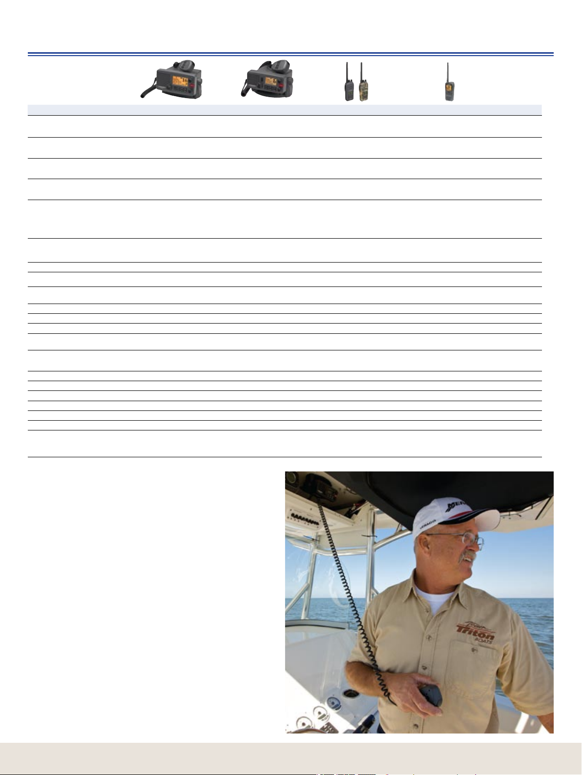
Specications
VHF
VHF/GPS Characteristics Fixed Mount LVR-880 Fixed Mount LVR-250 Portable LHR-20/22 Portable Combo LHR-80
Dimensions (HWD) and weight – w/o
Bracket, Mike, or antenna
LCD Display (HW)
Channel Bank (US) and Select
Operation
Hand Mike Features
Power Supply/Battery Life
Audio Output Power
Digital Selective Calling - DSC
DSC Call Types
Directory/MMSI Entry
(US)
Get Buddy
Call Logs
GPS Input + Output
Hailer with Intercom Talkback/
External Speaker
Navigation with Waypoints and MOB
FM Stereo Radio
S.A.M.E. Weather Alert
NOAA Weather Alert
Local/Distance
3 Favorite Channel Select/Scan
12db Sinad Sensitivity
Other Standard Features
3.8” x 7.1” x 6.1”
96 x 180 x 156mm
3.7 lbs (1.66 kg)
Backlighted FSTN
Full bitmapped (64 x 128)
1.3” x 2.6”; 33 x 71mm
All USA, International, Canada,
10 NOAA Weather, Rotary Control
PTT button, Hi/Lo, WX, CH16/9, 3CH,
channel up/down, built-in speaker and
backlighting
13.8 vDC±15% 13.8 vDC±15%
2W - 8Ω @ 10% distortion
94dBA internal speaker 4W - 4Ω @ 10%
distortion with external speaker
SC-101 US SC-101 US — SC-101 US
All calls are available - including high resolution
position polling and Track-Your-Buddy
20 Individual + Group MMSI + User MMSI 20 Individual + Group MMSI + User MMSI — 20 Individual + Group MMSI + User MMSI
— — —
20 Individual/10 Distress 20 Individual/10 Distress — 20 Individual/10 Distress
NMEA 0183/NMEA 2000
Powerful 22W Hailer with Auto/manual sounds
and listen-back, plus external speaker jack
200 Waypoints with instant GO control — —
USA/EU/AUS bands — — —
County-by-County warnings — — —
YES YES YES YES
YES YES
YES YES
.25uV (distant)/2.5uV (local) .25uV (distant)/2.5uV (local) .25uV .25uV
Flush mount kit and sun cover included.
Memory upgrades via NMEA2000.
®
2.8” x 6.3” x 6.1”
72 x 160 x 156mm
2.8 lbs (1.29 kg)
Backlighted FSTN
1.0” x 1.8”; 26 x 46mm
4 line x 12 Character + Icons
All USA, International, Canada,
10 NOAA Weather, Rotary Control
PTT button, Hi/Lo, WX, CH16/9, 3CH,
channel up/down, built-in speaker and
backlighting
2W - 8Ω @ 10% distortion
89dBA internal speaker 4W - 4Ω @ 10%
distortion with external speaker
All calls are available - including high resolution
position polling
NMEA 0183 — NMEA 0183 output while on cradle
No Hailer - has external speaker jack — —
Flush mount kit and sun cover included.
5.35” x 2.28” x 1.20”
136 x 58 x 30.5mm
0.62 lbs (0.28 kg) with battery
Backlighted FSTN
0.8” x 1.4”; 20 x 35mm
Custom Digits + Icons
All USA, International, Canada, 10 NOAA
Weather, ATIS – UP/DOWN control
— —
7.4 v – 1600 mAh Li-Ion
>10 hr (5W 5%, 5%, 90% ratio) >13 hr (1W
5%, 5%, 90% ratio) With battery level indicator
250mW internal speaker 250mW internal speaker
—
— —
Memory CH Select/Priority scan
4 bar signal strength meter. LHR-22 has
RealTree Advantage HD CAMO pattern and
includes a CAMO AA tray.
5.50” x 2.67” x 1.50”
139.7 x 67.8 x 38.1 mm
0.70 lbs (0.318 kg) with battery
Backlighted FSTN
Full bitmapped (128 x 128)
1.52” x 1.52”; 38.7 x 38.7mm
All USA, International, Canada,
10 NOAA Weather –
UP/DOWN control
7.4V – 1400 mAh Li-Polymer
>8 hr (5W 5%, 5%, 90% ratio, GPS on).
230ma in Standby
>9 hr (1W 5%, 5%, 90% ratio GPS off).
70ma in Standby
With battery level indicator
All calls are available - including high resolution
position polling and Track-Your-buddy
YES
500 Waypoints with instant GO control. One
track with 200 Trackpoints/control. Selection
to show nearest 5 Waypoints
YES
IT FLOATS. Built-in 12-channel GPS receiver
with lat/lon output, Great Circle navigation
trackplotter display, local waypoint icons and
cursor control. GPS satellite screen.
All VHFs share the following features:
Tx Power: 25W/1W xed, 5W/1W portable + indicators
Current Drain: 6A at 25W/1.5A at 1W xed mount
1.75A at 5W/0.8A at 1W portable
Battery monitor: Yes – level indicator with portable
Compass safe distance: 0.45m – xed mount
Temperature Range: -4 to 122°F (-20 to 50°C)
Waterproof Rating: JIS7
Antenna Connector: SO-239; SMB – portable
Transmitter Protection: Open/Short circuit of antenna
Modulation Distortion: <4% at 1kHz with ±3Khz deviation
Frequency Control: PLL with ±10ppm stability
Max frequency deviation: ±5Khz
NOAA Tone Wx Alert: Yes
All Scan/Dual watch/Tri watch Memory Scan: Yes
Residual Noise Level: More than -40dB unsquelched
Adjacent Noise Level: More than 65dB
Spurious Response: More than 65dB
Intermodulation Rejection Ratio: More than 65dB
Residual Noise Level: More than -40dB unsquelched
44
Page 45

iFINDER®
Handheld GPS
Specications
Receiver
Display
Background Map
Chart Options
Key Features
Position Points
Routes/Trails
Graphic Icons
Zoom
Case Size
Input Power
Battery Life
(w/1-second updates)
Weight
(w/batteries)
iFINDER®
HUNT c
16-channel
GPS+WAAS
2.83” Diag. (7.2 cm) 256-color
TFT
320V x 240H pixel white LED
backlit
Built-in enhanced USA
with major cities/
roads, Interstate exit service
and marine nav aids
MMC/SD memory card slot
to display MapCreate™,
FreedomMaps™,
Fishing Hot Spots®, LakeMaster®,
NauticPath™ and Navionics
Compass, Barometer, Hunt Mode,
Scout Mode, MP3, Voice Notes,
10 languages, NMEA 0183,
Back-up memory
Up to 2,000 waypoints & 1,000
event markers
Up to 100 routes & 100 plot trails
(10,000 points/trail)
63, + 17 exclusive hunting icons 63 63 42 42
40 ranges,
.02-4,000 miles
2.5” W (6.4 cm)
5.6” H (14.2 cm)
1.2” D (3 cm)
3 vDC (2 AAs) or
5-35 vDC
accessory
power cable
Up to 16 hours Up to 14 hours Up to 14 hours Up to 12 hours Up to 50 hours
8.7 oz (247 g) 8.7 oz (247 g) 8.7 oz (247 g) 8.7 oz (247 g) 5.36 oz (152 g)
iFINDER
EXPEDITION
16-channel
GPS+WAAS
2.83” Diag. (7.2 cm) 256-color
TFT
320V x 240H pixel white LED
backlit
Built-in enhanced USA
with major cities/
roads, Interstate exit service
and marine nav aids
MMC/SD memory card slot
to display MapCreate™,
FreedomMaps™, Fishing Hot
Spots®, LakeMaster®, NauticPath™
®
and Navionics
Compass, Barometer, Hunt Mode,
Scout Mode, MP3, Voice Notes,
10 languages, NMEA 0183,
Back-up memory
Up to 1,000 waypoints & 1,000
event markers
Up to 100 routes & 100 plot trails
(10,000 points/trail)
40 ranges,
.02-4,000 miles
2.5” W (6.4 cm)
5.6” H (14.2 cm)
1.2” D (3 cm)
3 vDC (2 AAs) or
5-35 vDC
accessory
power cable
™
c
®
iFINDER®
H20 c
16-channel
GPS+WAAS
2.83” Diag. (7.2 cm) 256-color
TFT
320V x 240H pixel white LED
backlit
Built-in enhanced USA
with major cities/
roads, Interstate exit service
and marine nav aids
MMC/SD memory card slot
to display MapCreate™,
FreedomMaps™, Fishing Hot
Spots®, LakeMaster®, NauticPath™
®
and Navionics
10 languages,
NMEA 0183,
Back-up memory
Up to 1,000 waypoints & 1,000
event markers
Up to 100 routes & 100 plot trails
(10,000 points/trail)
40 ranges,
.02-4,000 miles
2.5” W (6.4 cm)
5.6” H (14.2 cm)
1.2” D (3 cm)
3 vDC (2 AAs) or
5-35 vDC
accessory
power cable
iFINDER®
H20
12-channel
GPS+WAAS
3” Diag. (7.6 cm)
Film SuperTwist
240V x 180H pixel white LED
backlit
Built-in enhanced USA
with major cities/
roads, Interstate exit service
and marine nav aids
MMC/SD memory card slot
to display MapCreate™,
FreedomMaps™, Fishing Hot
Spots®, LakeMaster®, NauticPath™
®
and Navionics
10 languages,
NMEA 0183,
Back-up memory
Up to 1,000 waypoints & 1,000
event markers
Up to 100 routes & 100 plot trails
(10,000 points/trail)
40 ranges,
.02-4,000 miles
2.5” W (6.4 cm)
5.6” H (14.2 cm)
1.2” D (3 cm)
3 vDC (2 AAs) or
5-35 vDC
accessory
power cable
iFINDER® GO2
16-channel GPS+WAAS
2” Diag. (5 cm) Film SuperTwist
200V x 140H pixel
amber LED backlit
Built-in USA with major cities/
roads, Interstate exit service,
national parks and marine nav aids
none
10 languages, NMEA 0183,
Back-up memory
Up to 1,000 waypoints & 1,000
event markers
Up to 100 routes & 100 plot trails
(10,000 points/trail)
40 ranges,
.02-4,000 miles
2.12” W (5.4 cm)
5.15” H (13.1 cm)
1.24” D (3.15 cm)
3 vDC (2 AAs) or
5-35 vDC
accessory
power cable
Radar
LRA-1800 LRA-2400
Radome Radome
Type
Size/Weight
Output Power
Max. Range Scale
Beamwidth (H/V)
Voltage Required
Rotation Speed
** Specications are subject to change without notice
18 in. (45 cm)/
9 lbs. (4.2 kg)
2 kW 4 kW
24 nm 48 nm
5.2º/25º 4º/25º
10.8 – 15.6 vDC 10.8 – 42 vDC
27 RPM 27 RPM
24 in. (60 cm)/
22 lbs. (10 kg)
www.lowrance.com
45
Page 46

46
Page 47

47
www.lowrance.com
About Navico
Navico is the parent company to ve leading marine
electronics brands: B&G, Eagle, Lowrance, Northstar
and Simrad. Navico has approximately 2,500 employees
globally and is headquartered in Oslo, Norway. The
company has development and manufacturing facilities
in the USA, Mexico, the UK, Norway and New Zealand.
NAVICO AMERICAS
Corporate Headquarters
12000 East Skelly Drive
Tulsa, OK 74128-2486 USA
918.437.6881
About Navico
Canada Service Center
919 Matheson Blvd. East
Mississauga, Ontario
CANADA L4W 2R7
905.629.1614
www.lowrance.com
Customer Service:
Weekdays:
800.324.1356 (continental USA)
800.661.3983 (Canada)
Anytime:
www.lowrance.com/support
Self-service product answers and services
Parts/Accessories:
Weekdays:
800.324.1356 (continental USA)
800.661.3983 (Canada)
Anytime:
www.lei-extras.com
All trademarks are property of their respective owners. Products, features and
specications are the most recent available at the time of printing and are subject
to change without notice. Lowrance reserves the right to make changes and
improvements in our products periodically without incurring the obligation to install
such improvements and changes on equipment or items previously manufactured.
©2008 Navico, Inc.
Page 48

988-0173-04 1208
www.lowrance.com
A Navico brand – Leader in Marine Electronics
 Loading...