

Lowrance LMS-10 LORAN User Manual
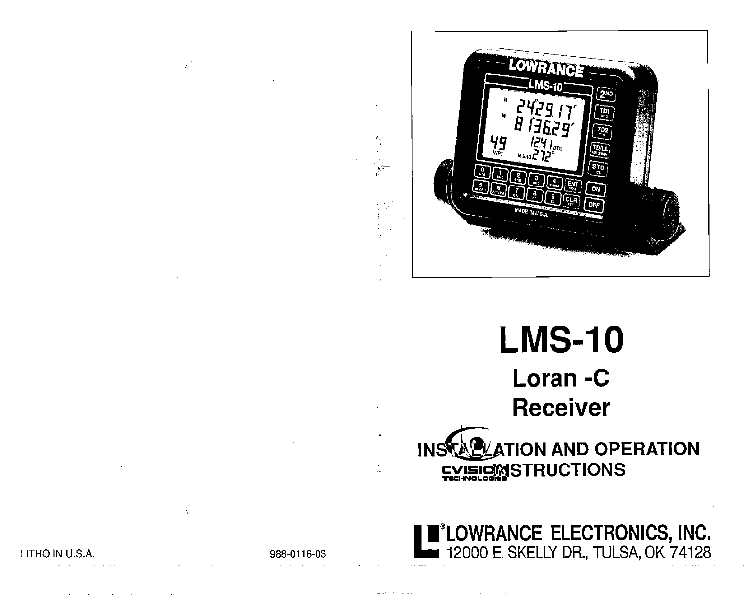
LMS-1O
Loran -c
Receiver
AND OPERATION
ELECTRONICS,
DR., TULSA,
OK 74128
INC.
LITI-lO IN U.S.A. 988-0116-03
INSTALLATION
INSTRUCTIONS
•LOWRANCE
12000 E. SKELLY
PDF compression, OCR, web-optimization with CVISION's PdfCompressor
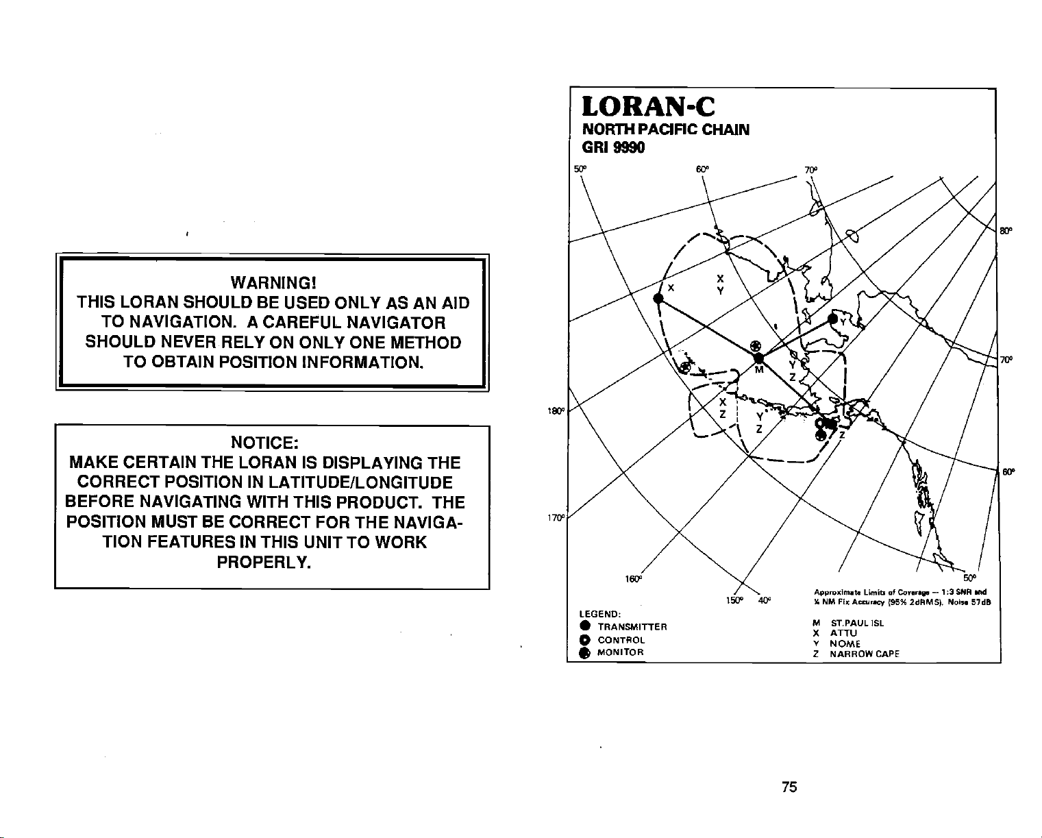
WARNING!
THIS LORAN SHOULD BE USED ONLY AS AN AID
TO NAVIGATION. A
SHOULD NEVER RELY ON ONLY ONE METHOD
TO OBTAIN POSITION
MAKE CERTAIN THE
CORRECT POSITION IN
BEFORE
POSITION MUST BE CORRECT FOR THE
NAVIGATING WITH THIS PRODUCT. THE
TION
FEATURES
PROPERLY.
CAREFUL NAVIGATOR
INFORMATION.
NOTICE:
LORAN IS DISPLAYING THE
LATITUDE/LONGITUDE
NAVIGA-
IN
THIS UNIT TO WORK
170°
75
PDF compression, OCR, web-optimization with CVISION's PdfCompressor
TABLE OF CONTENTS
NORTH PACIFIC LORAN-C CHAIN GR1 9990
REGONAL MANAGER COMMANDER. PACIFIC MREA.
CHAIN MANAGER:CDMMANDER. 17TH CDASTGUARD DISTRICT.
COORDINATOR
CONTROL SITE: LORMDNSTA
D53IG. STATIIY4 COOn.
MASTER St PALL
XRAY ATru
YANKEE
ZULU NR0W
OF CHAIN
AK
AK
PORT
CLARENCE
AK
CAPEAK
OPERATIONS
170 l000.eW
173 1040.0!
1605312.6W 3058,05
162= 113W 3600.45
AK
KODIAK,
COSU.
670912301
624944.ON
0t14403N 2t000/
57262029) 43000/
11000/
3a7L25
LOCATION:
luuI
ALAMEDA.
LORMONSTA KODIAK.
XMTTrER
ANTFFN.42 325 625 FT
ANTFPW-42 320 62SF]
MVFR4-42
AN/FPN44A
CA
PWR
1KW)
JUNEAU,
ANTENNA
AK
AK
TRANOENT
MOIOPOI.E
601OLE
10 1350 Ft
601tW0L5
400 626
0fl4oPCt0
604
ECD
0.0
0.0
.0,6
0.0 OUAL RA1E W/OHI7000
FT
NOTES
LORAN-Genera]
ACCURACY
HOW LORAN-C WORKS
INSTALLATION
INSTALLATION - LC-1
POWER CONNECTIONS
LORAN OPERA11ON- INITIALIZATION
SELECT CR1
ENTERING INITIAL POSITION - LAT/LONG
CYCLE ERRORS AND SNR
AUTOMATICAND MANUAL
MANUAL STATION SELECTION
Viewing
Viewing
Selecting
PRIMARYANDALTERNATESOLUTICNS
DISPLAY - Overview
TD/LL
HEADING
TIMETO GO
DISTANCET000(DTG)
SPEED OVER GROUND
VELOCITY MADE GOOD 19
TRUE/MAGNETIC BEARING
CROSS TRACK ERROR
CROSSTRACKERRORPERARROW
SIGNALTO NOISE RATIO
Fix DUALITY 22
I-IOWTOSAVEAWAYPOINT
Saving
Enter New
Enter New
ERASING A WAYPDINT 28
WAYPOINTRECALL
WAYPDINTCOUNTEROFFSET
GOTOWAYPOINT 28
VIEW DESTINATION WAYPDINT 29
VIEW STARTING WAYPOINT 29
ROUTES 29
Creating
Following
Can00lling
Eraaing
ALARMS
AnochorAlarrn 32
Arrival
ASF CORRECTION
NMEA OUTPUT
24HOURCLDCK-TIMER 36
LIGHTS
CLEAR LOWER DISPLAY 37
Fl and F2 38
RESTARTLDRAN
SeledNewORI 39
Enter New Initial Poaition
RESET 41
VIEWING T.D.S IN USE
MAGNETIC VARIATION 42
VERSION NUMBER
STAT
SIMULATOR
HOW TO OBTAIN SERVICE
COMMAND LIST
KEYBOARD 2nd FUNCTION LIST 45
FACTORY DEFAULTS
-
Unil
DpIay
Loran-C Module 4
MODES ID
Stations in Use
Reornerided Stations
Stations
(HDG)
(TIC)
(X1E)
(SNR)
Current Position
Waypoint - LatitudelLongitude
Waypoinl
a Route
a Rowe 31
a Route
a Route
Alarni
-
TDs
(Quick
Save
Feature)
3
7
12
12
12
13
14
15
16
17
17
18
18
19
20
21
21
22
22
23
25
27
28
29
31
31
31
32
35
36
39
40
42
42
42
43
43
44
45
1
1
1
8
Copyright
All features and
©
1989,
All
rights
Lowrance
reserved.
specifications subject
Electronics,
to
change
Inc.
without notice.
74
PDF compression, OCR, web-optimization with CVISION's PdfCompressor
LORAN-C
ICELANDIC CHAIN
9980
GRI
LEGEND:
• TRANSMITTiNG
CONTROL
o
MONITOR
*
73
Approximat.
4 NM Fix
M SANDUR
W ANGISSOQ
X EJDE
Limit of
Accurmey jSG%
—-1:3 SNP
Conre
2dRMS). Noise 46dB
md
PDF compression, OCR, web-optimization with CVISION's PdfCompressor
LORAN - GENERAL
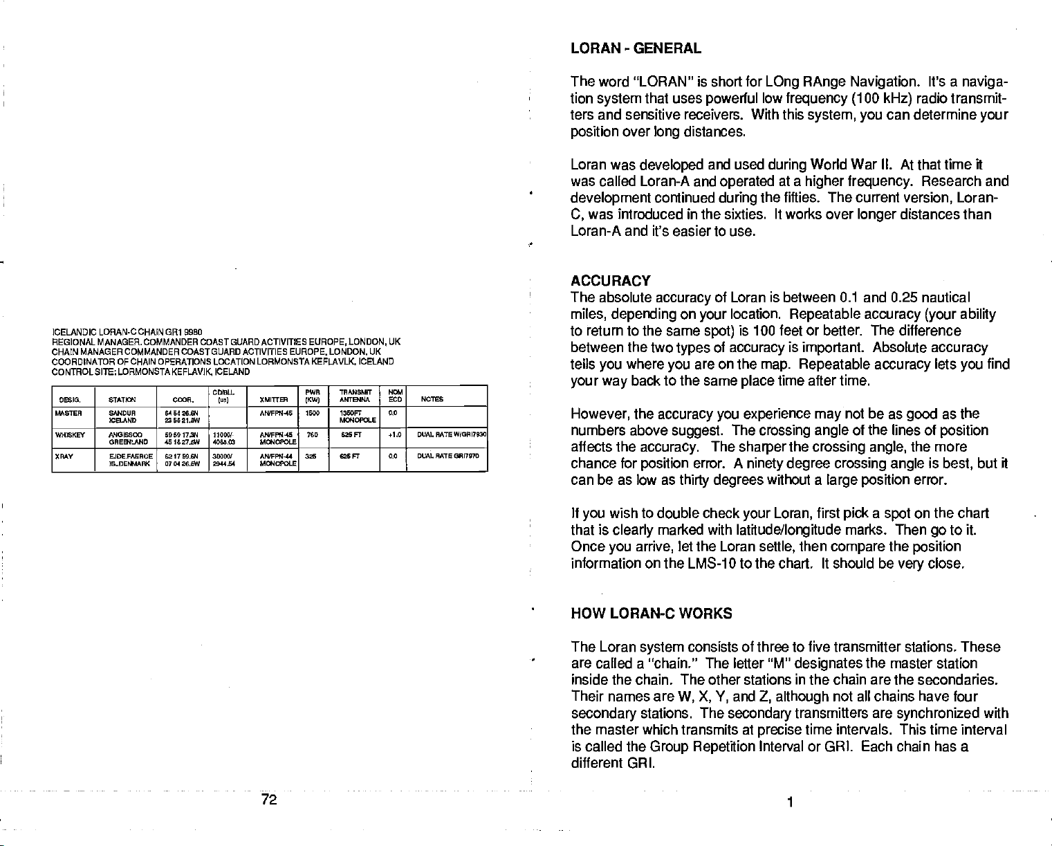
ICELANDIC LORAM.C CHAIN GRI 9980
REGIONAL MANAGER. COMMANDER COASTGUARDACTIVITIES
CHAIN MANAGER COMMANDER COASTGUARO ACTIVITIES EUROPE. LONDON,
COORDINATOR OF CHAIN OPERATIONS LOCATION LORMONSTA KEFLAVLK.
CONTROLSITE;LORMONSTAKEFLAVIK
D55. &ATJa1 C(R.
56867EA SN4DUA
W24EKEY ANGIS000
XAAY
ICELAND
OAES4LAND
EJDE.FAEAOE
IS..OESWFK
6454 26.64
5521,5W
5959 I7N
451627.5W
6217 55.64
0704 26,5W
ICELAND
CDULS.
Iv,) (MITtEn
AWFFSJ.45 '500 I350FT
11055!-
4068.62
35555!
2814$4
NQFFW4S
5flIOLE
NWFPN-44
MIY4C9OLE
EUROPE, LONDON,
PWR
TRMSSMff
ANTB4MA
1KW)
Ma40Pa6
765 625 FT +1.0 DUAL RATE W?09l7920
325 625 FT 0.0 DUAL RATEOWI757O
UK
ICELAND
UK
N62I
LCD NOISE
0,0
The word "LORAN" is short
lion
system
that uses
ters and sensitive receivers. With this
position
Loran was
was
over
developed
called Loran-A and
development
was introduced in the sixties. It works over
C,
distances.
long
continued
for
powerful
and used
operated
during
LOng RAnge Navigation.
low
frequency (100
system, you
during
the
World War II.
at a
higher frequency.
fifties. The
Loran-A and it's easier to use.
ACCURACY
The absolute
accuracy
miles, depending
to return to the same
between the two
tells
your way
However,
numbers above
affects the
chance for
where
you
back to the same
the
accuracy you experience may
accuracy.
position
you
suggest.
can be as low as
of Loran is between 0.1 and 0.25 nautical
on
types
thirty degrees
location.
your
is 100 feet
spot)
of
accuracy
are on the
place
The
The
sharper
error. A
ninety degree crossing angle
Repealable accuracy (your ability
or
is
important.
map. Repeatable
time after time.
crossing angle
the
crossing angle,
without a
kHz)
can determine
current
longer
better.
The
Absolute
accuracy
not be as
of the lines of
large position
It's a
naviga-
radio transmit-
your
At that
time it
Research
version,
Loran-
distances than
difference
accuracy
lets
you
as the
good
position
the more
is
error.
best,
but it
and
find
If
wish to double check
you
that is
Once
clearly
marked with
you arrive,
let the Loran
your Loran,
latitude/longitude
settle,
information on the LMS-1 0 to the chart. It should be
first
then
pick a spot
marks. Then
compare
the
on the chart
go
position
close.
very
to it.
HOW LORAN-C WORKS
The Loran
system
are called a "chain." The letter
inside the chain. The other stations
Their names are
secondary
stations. The
the master which transmits at
is called the
consists of three to five transmitter stations. These
W, X, Y,
and
secondary
Group Repetition
"M"
designates
in
the chain are the secondaries.
Z,
although
transmitters are
precise
time intervals. This time interval
Interval or GRI. Each chain has a
the master station
not all chains have four
synchronized
with
different GIRl.
72
1
PDF compression, OCR, web-optimization with CVISION's PdfCompressor
The
secondary
stations transmit at
precise
time intervals after the
master station transmits. Since these transmitters are
dreds of miles
transmitter
to
reach
difference between the master and two of the
10
automatically
location. The
Plotting
time difference or
TO
the
somewhere on a line of
line on which
nary
secondaries is the
it takes a different time for
apart,
The Loran
you.
receiver measures this time
the
secondaries, the LMS-
chooses the best
master-secondary pairs
is measured in
(TO)
on a chart with Loran-C lines results
position (LOP).
the time
same.
In
delay
this
example
A line of
between the master and one of the
position
the boat is located some-
signals
with
where on the 14605.2 LOP.
located hun-
from each
for
your
micro-seconds.
your position
is an
imagi-
LORAN-C
NORTHWEST PACIFIC CHAIN
9970
GRI
The Loran receiver then measures
master and another
this LOP on a
plot
position.
Your
secondary.
chart,
position
you'll
is at the
the time difference between the
In this
notice
intersection of the two lines.
example
that it crosses the first line-of-
it's 31882.8. If
2
you
0
I
—
—.
.,
1
—-_
Asprnlwdn
)M
S
II
W
X HOXXAIDO
LS,t of
Fis
£ncy (P5% 2flMS(.
IWOJIMA
MARCUS IS.
t GESASHI
2 3ARAGADA
__..._.___.___
t.nr.p
'C.
71
—
13 $fl rid
Pa... 44d1
C
-.
PDF compression, OCR, web-optimization with CVISION's PdfCompressor
All Loran-C receivers work on this
also
display latitudeflongitude.
and, using
longitude position
longitude
a
complex
data. You can
on the LMS-1 0 to determine
mathematical
The receiver takes
principle.
formula,
display
your
Most modern receivers
the TD information
converts it to latitudef
both TD's and latitude!
position.
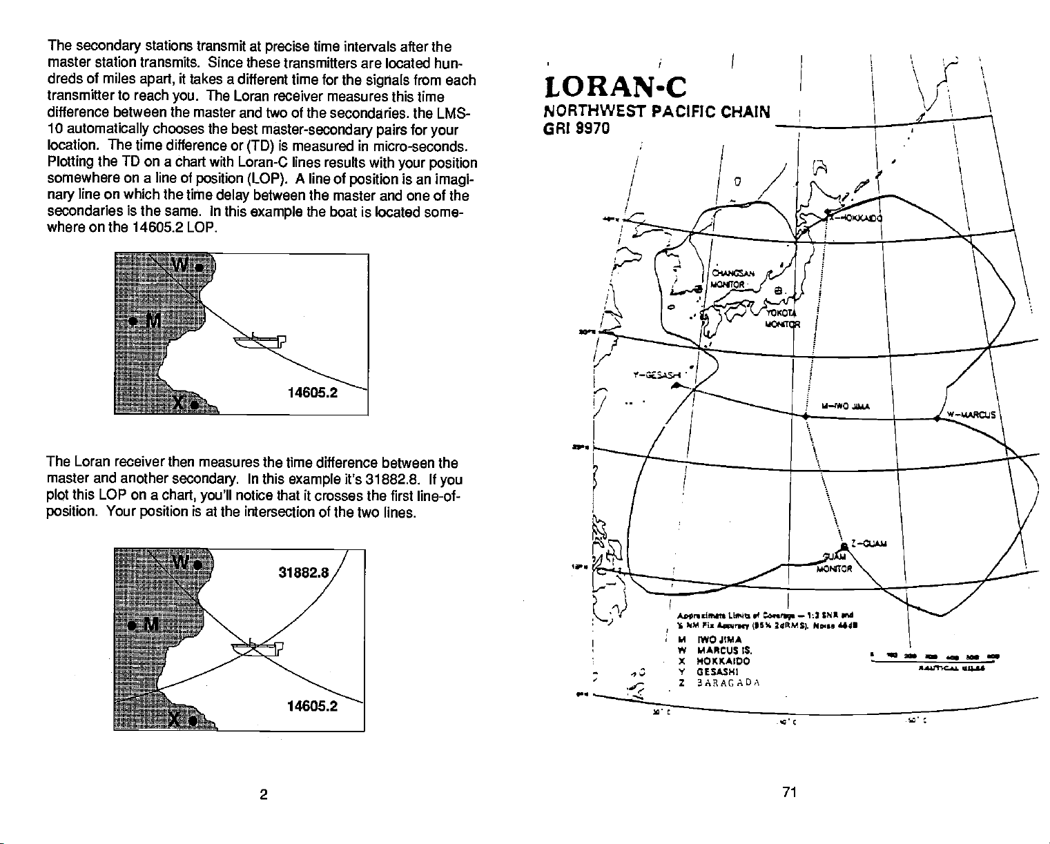
NORThWEST PACIFIC LORAN.C CHAIN CR1 9970
REGIONAL MANAGER COMMANDER. PACIFICAREA, ALMAEDA, CA.
CHAIN MANAGER
COORDINATOR OFCHAIN OPERATIONS LOCA11ON. COMMANDER. FAR EASTSECTION. YOKOTA,
CONTROL SITE
DES'S. &ATTa4 CDOR.
MASTER M0JI
WHEXEY IMRCUEISLAND
XMY HOKKAIOO
YANKEE GESASHI
ZULU BARRIGADA 1327E0.IN
COMMANDER,
LORMONSTAYOKOTA,
JAPAN
JAPAN
JAPAN
JAPAN
14THCOASTGUARD DISTRICT,I-IONOLULU, HI
JAPAN
244E03.E14
141193020
241707.914
153 58 53,2E
424437.111
1134309.25
283825.011
1280886.45
444933.00
COBIL
lusI
110801
4283.58 ANIFPR145
38080!
8686.17
58080/
448328
2528.84$
81080
XMITrER
AWFFN-45 1815
AN/FPW4S 800
ANPPN'IS 828 FT
PWR
(XW}
2150
500
WNSMFr
ANTENLA
1380FT
Magopa.E
1280 FT
MWOPOLE 0.0
G2SFT
Ma4OPOLE
Ma40LE
7SOFT
N0l
EUD NOTEE
0.0
0.8 DUALRATEW/0RI5970
0.0 DUAL RATE W10918970
JAPAN
It
wish to know more about
you
Coast Guard's book
book that describes Loran in
"Loran-C USER HANDBOOK."
greater
Loran-C User's Handbook
COMDTINST
Superintendent
U.S. Government
Washington,
Code
#050-012-00171-5,
There is a small
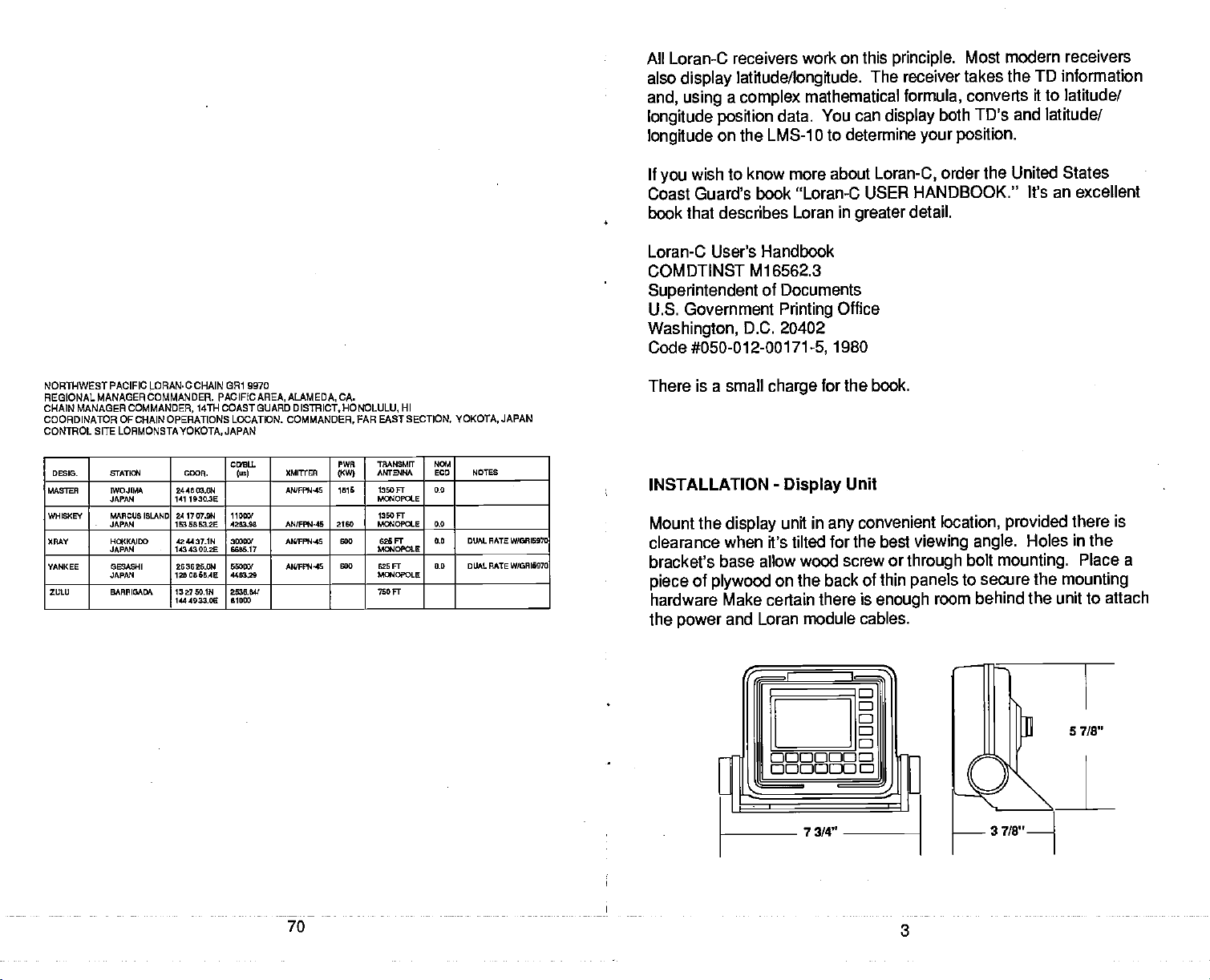
INSTALLATION
Mount the
clearance when it's tilted
Ml 6562.3
Documents
of
Printing
D.C. 20402
charge
-
Display
display
unit in
Office
1980
for the book.
Unit
convenient location,
any
for the best
bracket's base allow wood screw
of
piece
plywood
hardware Make certain
the
power
and Loran module
on the back of thin
there is
cables.
Loran-C,
detail.
viewing angle.
or
through
panels
enough
order the United
States
It's an excellent
provided
there is
Holes in the
bolt
mounting.
to secure the
room behind the unit to
Place a
mounting
attach
70
3
PDF compression, OCR, web-optimization with CVISION's PdfCompressor
You can
mounting
hole,
the
cover the hole.
route the cables
surface.
then
pass
the
through a three-quarter
First,
bring
cable down it. After
power
hole with silicone rubber adhesive
Route the cables
the Loran
(RN).
through
inch
hole
module's cable
routing
the
Offset the bracket to
the slot
SLOT
in
the bracket.
in
up
through
cables,
the
the
fill
INSTALLATION
Enclosed with
tains the
for the
tennas, wires, masts,
ferred,
complete
LC-1,
however for
highest part
Make certain it is as far
Improper performance
close to
places
and
You must
antenna.
metal
the Loran
obstructed.
purchase
The threads are standard 318"-24 for the
mount base is most
The base
mounting
(NOT pipe thread).
hardware.
Tighten
all hardware
-
LC-1 Loran-C MODULE
the LMS-1O is a LC-1 Loran-C module. This con-
your
loran
receiver. When
remember to install the
or other
lightning protection,
obstructions.
of the boat. The antenna
as
away
can also occur if the antenna is mounted too
objects
such as tuna towers.
assembly
an
eight
commonly
threads are conventional 1"-14 machine thread
This allows the use of standard antenna
securely.
possible
in the clear is
foot stainless steel or
used to mount the Loran
4
choosing a mounting
LC-1 where it's clear of other an-
A
high
location is
location
pre-
the antenna shouldn't be the
should be mounted
vertically.
from VHF radio antennas.
Again,
preferable
a location
to
one that is
that
high
fiberglass whip
A
whip.
ratchet
to the boat.
mounting
69
PDF compression, OCR, web-optimization with CVISION's PdfCompressor
The cable
supplied
cable lilt's too
with the LC-1 is
Instead,
tong.
coil and store it out
thirty
feet
Do not cut the
long.
of
the
extension cable is available it the cable is too short. Ask
call
your
Service
local service center or the Lowrance
department
for more information.
Factory
Customer
way.
your
An
dealer or
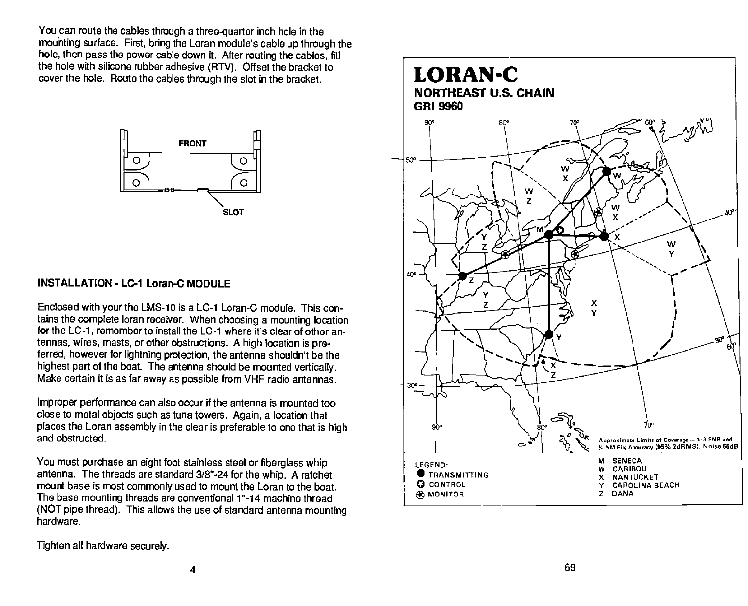
NORTHEAST U.S. LORAN-C CHAIN GRI 9960
REGIONALMANAGERCOMMANDER.
CHAIN MANAGER
COORDINATOR OF CHAIN OPERATIONS
CONTROL SITE: LORSTA
00210. STATIa4
WASTER
WHISKEY
XRAY NNJI1JCKET
YAM(EE CARQJ(A
ZLLU DANA *4 3551 (7.91 540
COMMANDER. ATLANTICAREA, NEWYORK, NY
SENECA, NY
NY 424250.621
SENECA,
I.E
CARIBOU,
MA
EECH,NC
ATLJTICAREA.
LOCATION: LORSTA SENECA, NY
CDEU.
COCA.
754933.9W
4648271
575537.7W
4115 ThEI.
555835.1W
340346.IN
775446.7W
6729121W 3152.20
(56)
Il0
2757.20
250
1502.93
39060!
3221.64
PWR
(KWI
NY
IRAPffiMIT
ANTBNA
700FT'
-
MGIOFOLE
MG4OFOLE
M4OPQ.E
POH
ECU NOIES
0.0 DUAL RATE 500915972
DUAL RATE W/0RI5930
'5.5 DUAL RATE W!0R18570
NEWYORK.
XMTTER
MOIFFT'144 800
(56HC0SI
N4WP9442 360 SLT 0.0 DUAJ. BAlE W/OBE93O
MUFPR412 320 525 FT 05
WFFI4A2 550 'TIP 0.0 DUALRATEW/ORI7SSO
A9UFFS+44 460 625 PT
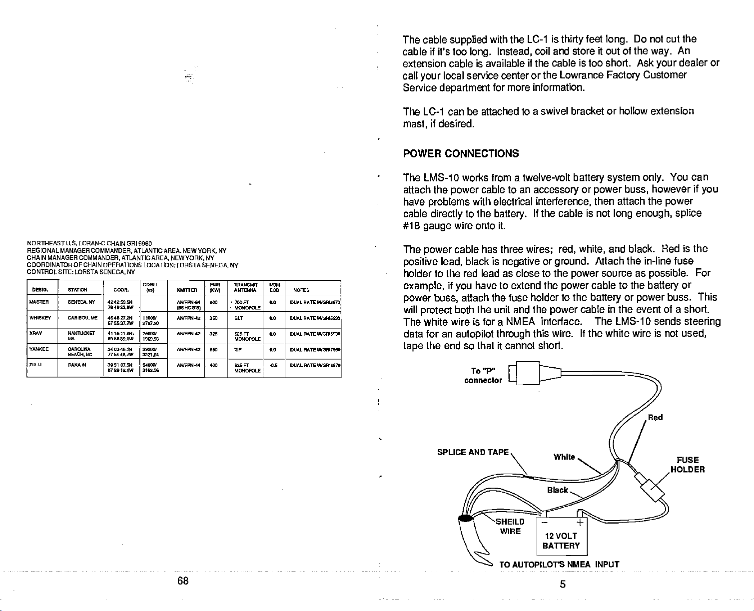
The LC-1 can
it desired.
mast,
be attached to a swivel bracket or hollow extension
POWER CONNECTIONS
The LMS-1
attach the
have
cable
#18
The
positive lead,
0 works from a twelve-volt
power
problems
directly
gauge
power
to an
cable
with electrical
to the
battery.
wire onto it.
cable has three
black is
negative
accessory
interference,
If the cable is not
wires; red, white,
or
ground.
holder to the red lead as close to the
if
example,
power
will
buss,
protect
The white wire is for a
data for an
end so that it cannot short.
the
tape
have to extend the
you
attach the fuse
both the
unit and the
NMEA interface. The LMS-1 0 sends
autopilot through
To "P"
connector
power
holder to the
power
this wire. If the white wire is not
battery system only.
or
power
buss,
then attach the
long enough,
You can
however if
power
splice
and black. Red is
Attach the
power
cable to the
battery
source as
in-line fuse
battery
or
power
possible.
or
buss. This
cable in the event of a short.
used,
you
the
For
steering
SPUCE AND TAPE.
TO AUTOPILOT'S
68
PDF compression, OCR, web-optimization with CVISION's PdfCompressor
NMEA INPUT
5
FUSE
HOLDER
To connect an
cable from the
Guide's
and the shield to the black wire on
power
the shield to the
instructions.
wiring
autopilot
autopilot's
cable. Solder the
autopilot.
to the
NMEA
See
LMS-1O,
your autopilot's
attach a
to the white wire on the Nay-
intput
the
conductor
power
ground
shielded,
of the twisted
cable. Do not connect
manual for more
twisted
pair
pair
Once the cable is
See the NMEA
LORAN OPERATION
connected,
Output
Initialization
The Loran must be
used. It then
off. If
used the
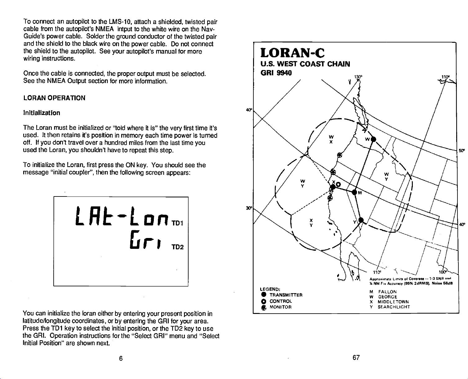
To initialize the
message
don't travel
you
Loran,
"initial
initialized or "told where it is" the
retains ft's
you
Loran,
coupler",
LREOLORTD1
the
proper
section for
have to
press
in
the ON
position
over a hundred miles from the last time
shouldn't
first
then the
output
more information.
memory
repeat
key.
following
5
must be selected.
very
each time
this
You should see the
screen
power
step.
appears:
TD2
first time it's
is turned
you
5Q0
40°
You can initialize the loran either
latitude/longitude
Press the TDI
the GRI.
Initial Position" are shown next.
Operation
coordinates,
to select the initial
key
instructions for the "Select GRI" menu and "Select
or
by entering your present position
by entering
position,
6
the GRI for
or the TD2
your
key
in
area.
to use
67
PDF compression, OCR, web-optimization with CVISION's PdfCompressor
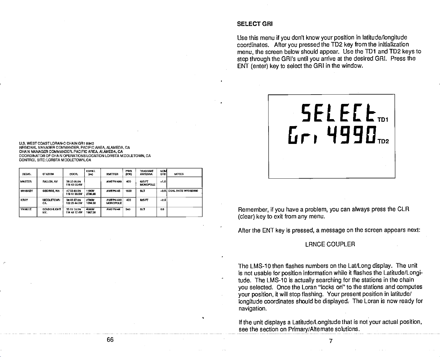
SELECT
GRI
U.S. WEST COAST LORAN-C CHAIN CR1 DO40
REGIONAL MANAGER COMMANDER. PACIFIC AREA. ALAMEDA, CA
CHAIN MANAGER COMMANDER. PACIFIC AREA. ALAMEDA. CA
COORDINATOR OF CHAIN OPERATIONS LOCATION LDRSTA MIDDLETOWN, CA
CONTROL SITE: LCRSTA
DESIS- SIATIaI ODOR-
MASTER FALOCH.
WHIGKEY
OMY MIDDLETOWN
YANKEE SEARCHLIGHT
0EOR00
CA-
NV-
MIDDLETOWN,
WV 3033066W
11649 56.4W
WA 470348.0W
1104439.6W
3046 570W
1332944.5W
361910.2W
1144817.4W
CA
C040.L
los)
110001
270690
270
1254.00
400
1067.30
PINE
008T1E5
MJIFPN44A
AI81Pt445 1600 50.T i-OS DUALRATEW(ORIS990
AMIFPO4-44A
Ma4OPOLE
AW'Ffl14l 640 SIT 0.0
111.445081
ANTEHNA
0KW)
400 5
400 030 Fr +0.5
F
Ma4DPOLE
NGl
ECD NOTES
+1.0
Use this menu if
coordinates.
menu,
the screen below
step through
ENT
(enter)
Remember,
(clear) key
After
the GRI's until
key
if
you
to exit from
don't know
you
you pressed
should
to select
the GRI in the window.
have a
any
your position
the TD2
appear.
arrive at the desired GRI. Press the
you
problem, you
in
latitude/longitude
from the initialization
key
Use the
can
TD1
always press
and
menu.
TD2
keys
the CLR
to
After the ENT
key
is
pressed,
a
message
on the screen
appears
next:
LRNCE COUPLER
The LMS-tD then flashes numbers on the
is not usable for
position
tude. The LMS-1 0 is
selected.
you
your position,
longitude
Once the Loran 'locks on" to the stations and
will
it
coordinates should be
information while it flashes the
actually searching
stop flashing.
for the stations
Your
present position
displayed:
Lat/Long display.
The Loran is now
The unit
Latitude/Longi-
in
chain
the
computes
in
latitude/
for
ready
navigation.
If the unit
see the section on
displays a Latitude/Longitude
Primary/Alternate
66
PDF compression, OCR, web-optimization with CVISION's PdfCompressor
that is not
solutions.
7
your
actual
position,
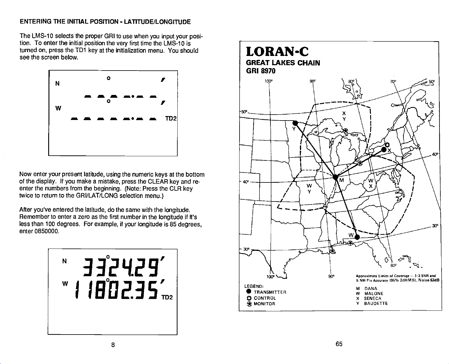
ENTERING THE INITIAL POSITION
-
LATITUDE/LONGITUDE
The LMS-10 selects the
tion. To enter the initial
turned
see the screen below.
on,
press
N
the TD1
proper
position
GRI
to use when
the
very
at the initialization
key
first time the
a a a a. a a
0
w
a a a a a a a TD2
Now enter
of the
enter the numbers from the
twice to return to the GRI/LAT/LONG selection
your present latitude, using
If
display.
you
make a
beginning. (Note:
mistake,
the numeric
the CLEAR
press
you input your posi-
LMS-1 0 is
menu. You should
at the
key
bottom
and re-
key
keys
Press the CLR
menu.)
After
you've
Remember to enter a
less than 100
enter 0850000.
entered the
zero as the first number in the
degrees.
N
latitude,
For
example,
do the same with the
longitude
if
your longitude
longitude.
if it's
is 85
degrees,
33°2'{29'
w
J
IB°Q2.3S.
8
PDF compression, OCR, web-optimization with CVISION's PdfCompressor
65
 Loading...