

Page 1

Garmin Pilot for Android
™
Page 2

Copyright © 2012-2021 Garmin Ltd. or its subsidiaries. All rights reserved.
This manual reflects the operation of Software version 7.7 or later. Some differences in operation may be observed when comparing the information in this manual to earlier or later software
versions. Some differences may also be observed when comparing the information in this manual
to your device.
Garmin International, Inc., 1200 East 151st Street, Olathe, Kansas 66062, U.S.A.
Contact Garmin Product Support at fly.garmin.com
Garmin AT, Inc., 2345 Turner Road SE, Salem, OR 97302, U.S.A.
Contact Garmin Product Support at fly.garmin.com
Garmin (Europe) Ltd., Liberty House, Hounsdown Business Park
Southampton, Hampshire SO40 9LR U.K.
Contact Garmin Product Support at fly.garmin.com
Garmin Corporation, No. 68, Zhangshu 2nd Road, Xizhi District, New Taipei City, Taiwan
Contact Garmin Product Support at fly.garmin.com
Web Site Address: flygarmin.com
Except as expressly provided herein, no part of this manual may be reproduced, copied, transmitted, disseminated, downloaded or stored in any storage medium, for any purpose without the
express written permission of Garmin. Garmin hereby grants permission to download a single
copy of this manual and of any revision to this manual onto a hard drive or other electronic storage medium to be viewed for personal use, provided that such electronic or printed copy of this
manual or revision must contain the complete text of this copyright notice and provided further
that any unauthorized commercial distribution of this manual or any revision hereto is strictly
prohibited.
Garmin®, SafeTaxi®, FliteCharts®, and VIRB® are registered trademarks of Garmin Ltd. or its
subsidiaries. Garmin Pilot™, D2™, D2 Air™ & Marq™ are trademarks of Garmin Ltd. or its
subsidiaries. These trademarks may not be used without the express permission of Garmin.
Jeppesen® is a registered trademark of Jeppesen, Inc.
NavData™ is a trademark of Jeppesen, Inc.
Android™ is a trademark of Google, Inc.
Canadian Radar is provided by Environment Canada.
©2021 The Bluetooth® word mark and logos are registered trademarks owned by Bluetooth SIG,
Inc. and any use of such marks by Garmin is under license. Other trademarks and trade names are
those of their respective owners.
Page 3
Warnings, Cautions & Notes
WARNING:
Do not rely solely upon the indicators shown on the Panel Display
Pane to maneuver the aircraft.
WARNING:
The altitude displayed by Garmin Pilot™ on the Panel Page is
geometric height above Mean Sea Level and could vary significantly from
the altitude displayed by pressure altimeters. Always use pressure altitude
displayed by the aircraft altimeter when determining or selecting aircraft
altitude.
WARNING:
Do not use outdated database information. Databases used in the
Garmin Pilot™ must be updated regularly in order to ensure the information
remains current. Pilots using any outdated database do so entirely at their
own risk.
WARNING:
To aid in device security, use a properly supported device that is
dedicated to the aircraft and not shared with personal use.
WARNING:
To reduce the risk of unsafe operation, carefully review and
understand all aspects of Garmin Pilot™ User documentation and the Pilot’s
Operating Handbook of the aircraft. Thoroughly practice basic operation prior
to actual use. During flight operations, carefully compare indications from
Garmin Pilot™ to all available navigation sources, including the information
from other NAVAIDs, visual sightings, charts, etc. For safety purposes, always
resolve any discrepancies before continuing navigation.
WARNING:
Garmin Pilot™ has a very high degree of functional integrity.
However, the pilot must recognize that providing monitoring and/or self-test
capability for all conceivable failures is not practical. Although unlikely, it may
be possible for erroneous operation to occur without a fault indication shown
by Garmin Pilot™. It is thus the responsibility of the pilot to detect such
an occurrence by means of cross-checking with all redundant or correlated
information available in the cockpit.
WARNING:
For safety reasons, Garmin Pilot™ operational procedures must
be learned on the ground.
Garmin Pilot for Android User’s Guide190-01532-00 Rev. U
Page 4
Warnings, Cautions & Notes
WARNING:
The United States government operates the Global Positioning
System and is solely responsible for its accuracy and maintenance. The GPS
system is subject to changes which could affect the accuracy and performance
of all GPS equipment. Portions of Garmin Pilot™ utilize GPS as a precision
electronic NAVigation AID (NAVAID). Therefore, as with all NAVAIDs,
information presented by Garmin Pilot™ can be misused or misinterpreted
and, therefore, can become unsafe.
WARNING:
Do not use basemap (land and water data) information for primary
navigation. Basemap data is intended only to supplement other approved
navigation data sources and should be considered as an aid to enhance
situational awareness.
WARNING:
Do not use the indicated data link weather product age to
determine the age of the weather information shown by the data link weather
product. Due to time delays inherent in gathering and processing weather
data for data link transmission, the weather information shown by the data
link weather product may be significantly older than the indicated weather
product age.
WARNING:
Do not use data link weather information for maneuvering in, near,
or around areas of hazardous weather. Information contained with in data link
weather products may not accurately depict current weather conditions.
WARNING:
Do not rely solely upon the display of traffic information for
collision avoidance maneuvering. The traffic display does not provide collision
avoidance resolution advisories and does not under any circumstances or
conditions relieve the pilot’s responsibility to see and avoid other aircraft
WARNING:
Do not rely solely upon the display of traffic information to
accurately depict all of the traffic within range of the aircraft. Due to lack of
equipment, poor signal reception, and/or inaccurate information from aircraft
or ground stations, traffic may be present that is not represented on the display.
Garmin Pilot for Android User’s Guide190-01532-00 Rev. U
Page 5
Warnings, Cautions & Notes
WARNING:
Use of an unapproved wireless device inserted into the SD card
slot of your Garmin navigator may induce a malfunction, may cause damage
to the unit, will void the Garmin warranty, and may nullify the airworthiness
approval of the installation. The only wireless device currently certified for
use in a compatible Garmin avionics system SD card slot is the Garmin Flight
Stream 510. Do not insert an unapproved wireless device into the SD card slot
of your Garmin avionics system.
NOTE:
All visual depictions contained within this document, including screen
images of Garmin Pilot™ panel and displays, are subject to change and may
not reflect the most current Garmin Pilot™ software and aviation databases.
NOTE:
Temporary Flight Restriction (TFR) data is provided by the FAA and
may not be updated outside of normal business hours. Confirm data currency
through alternate sources and contact your local FSS for interpretation of TFR
data.
NOTE:
Special Procedures. Prior to flying these procedures, pilots must have specific
FAA authorization, training, and possession of the corresponding current,
and legitimately-sourced chart (approach plate, etc.). Inclusion of the
Special Procedure in the navigation database DOES NOT imply specific FAA
authorization to fly the procedure.
The navigation databases used in Garmin navigation systems contain
Garmin Pilot for Android User’s Guide190-01532-00 Rev. U
Page 6

Software License Agreement
SOFTWARE LICENSE AGREEMENT
BY USING THE DEVICE, COMPONENT OR SYSTEM MANUFACTURED OR SOLD BY GARMIN (“THE
GARMIN PRODUCT”), YOU AGREE TO BE BOUND BY THE TERMS AND CONDITIONS OF THE FOLLOWING
SOFTWARE LICENSE AGREEMENT. PLEASE READ THIS AGREEMENT CAREFULLY. Garmin Ltd. and its
subsidiaries (“Garmin”) grants you a limited license to use the software embedded in the Garmin Product
(the “Software”) in binary executable form in the normal operation of the Garmin Product. Title, ownership
rights, and intellectual property rights in and to the Software remain with Garmin and/or its third-party
providers. You acknowledge the Software is the property of Garmin and/or its third-party providers and is
protected under the United States of America copyright laws and international copyright treaties. You further
acknowledge the structure, organization, and code of the Software are valuable trade secrets of Garmin
and/or its third-party providers and the Software in source code form remains a valuable trade secret of
Garmin and/or its third-party providers. You agree not to reproduce, decompile, disassemble, modify, reverse
assemble, reverse engineer, or reduce to human readable form the Software or any part thereof or create any
derivative works based on the Software. You agree not to export or re-export the Software to any country in
violation of the export control laws of the United States of America.
Garmin Pilot for Android User’s Guide190-01532-00 Rev. U
Page 7
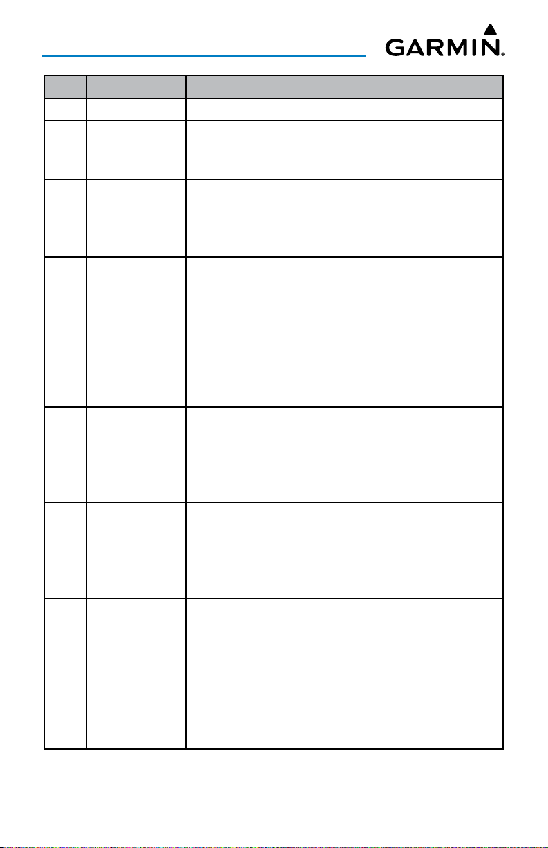
Rev Date Change Summary
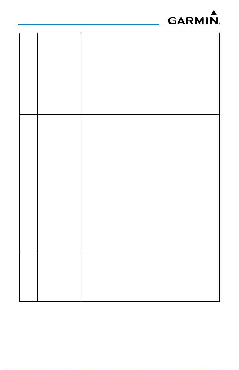
A December, 2012 Initial Release
B January, 2013 Updated for Application version 2.3:
Airport Information Page updates
Chart Next Cycle Downloads
C May, 2013 Updated for Application version 2.4:
Added Scratch Pad
Added Split-screen Traffic
Updated Trip Planning
D July, 2013 Updated for Application version 2.5 and 2.6
Added Airspace Widget
Added combined Map Layers
Changed Trip Planning to File & Brief
Added Routes to File & Brief
Added Display Time Format
Added Tools Menu for configuring time/distance alerts
Added Custom Own Ship Icons.
E November, 2013 Updated for Application version 2.7
Added Proposed Routes
Added Keep Screen on
Added Decoded TAFs
Added D2® Watch support
F January, 2014 Updated for Application version 2.8
Added support for the GDL 39 3D and a new attitude indicator
display in the navigation panel
Added 'right' traffic pattern directions for runways in the airport
browser and the airport information widget.
G April, 2014 Updated for Application version 3.0
Added support for vector maps that work offline
Added new distance measure tool
Added fuel range rings
Added ownship track vector
Added extended runway centerlines
Added auto-zoom feature
Added map decluttering options
Garmin Pilot for Android User’s Guide190-01532-00 Rev. U RR-7
Page 8
H August, 2015 Updated for Application version 4.3
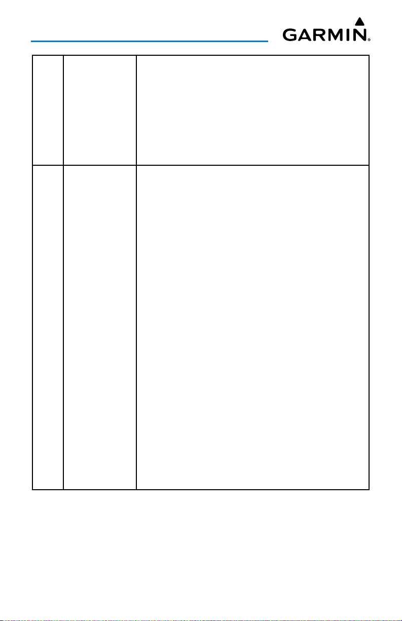
Added GDL 39 support
Added Connext features
Added Flight Stream support
Added alternate colors for flight conditions
Added Airport Facilities Directory
Added support for alternate storage locations, such as SD cards
Added G3X Touch support
Added GLO support
Added Terrain & Obstacles database
J April, 2016 Updated for Application version 5.1
Added support for GTX 345
Revised Trip Planning procedures
Added traffic alerts
Added support for Leidos Flight Service integration
Added descriptions of Chart binder and searching enhancements
Added multiple pages for the Scratch Pad
Added Screen Lock
Added Light and Dark modes
Added Night Mode for SafeTaxi
Added VIRB integration
Added support for Google Maps™ mapping service in Airport
Info
Added Airport Widget to split-screen setups
Added Demo Mode
Added warnings for trips with airports below VFR/IFR minimums
K April, 2016 Updated for Application version 5.2.1
Added Connext support for the aera 660.
Added altitude to the PIREP map overlay.
Personal minimums may now be added to a pilot profile.
Chart search on handsets now works like the tablet version.
Bookmarked flight plans can be renamed.
Garmin Pilot for Android User’s Guide190-01532-00 Rev. U RR-8
Page 9
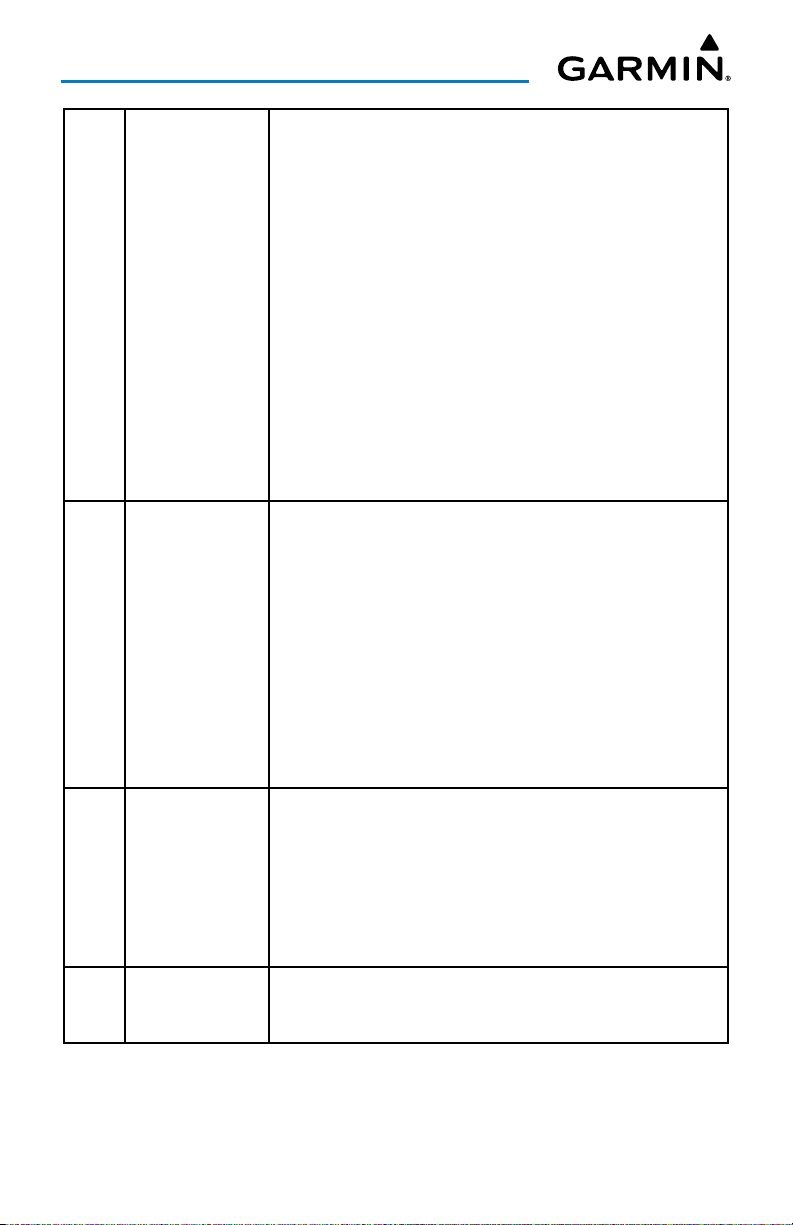
L November, 2016 Updated for Application version 5.4.4
Flight Stream 510 Integration
Logbook features
D2 Bravo and Bravo Titanium pilot support watches
Altitude and report age filtering for Map PIREP overlay
Sequential chart navigation & chart printing features
Best Runway recommendations added to Airport Information
and airports widget
M March, 2018 Updated for Application version 6.3
Worldwide Winds Aloft Coverage
Icing Forecast
Radar and Infrared Satellite Color Palettes
Chart Overlays
Enhanced Stadium TFRs
Glide Range Ring
Logbook Tracks
Auto-Download Pilot Updates
D2 Charlie Series watch support
Split Screen Synthetic Vision
Checklists
GDL 51/51R
GDL 52/52R
Virb 360 Camera Support
Logbook Photos
Logbook Auto-Logging
FastFind Predictive Waypoint Entry
Helicopter Charts
Units Preferences
Nearest (NRST) navigation functionality
Airspace Altitude Labels
Highest Point Along Route
Synthetic Vision
Garmin Pilot for Android User’s Guide190-01532-00 Rev. U RR-9
Page 10
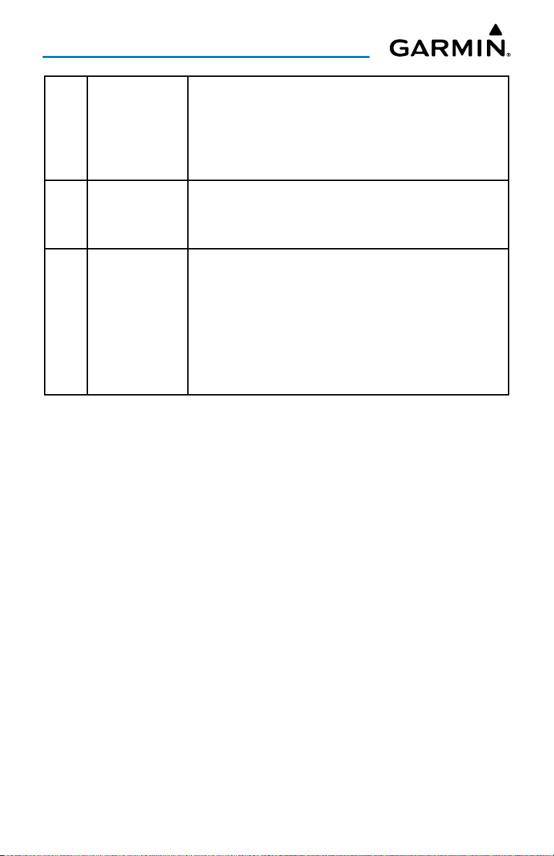
N July, 2019 Updated for Application version 7.2
Advanced Aircraft Performance
Weight & Balance
Storm Cell Movement
Area Forecast Discussion
D2 Delta PX Support
MARQ Aviator Watch Support
Weather Imagery
Quick Fuel Set
Added SiriusXM Lightning, TFRs, Echo Tops, Winds Aloft, & Icing
GPS175/GNX375 Support
Model Output Statistics (MOS)
Base Reflectivity Radar
FBO Fees
P November, 2019 Updated for Application version 7.3
Images Refreshed Throughout
Bug Fixes Throughout
GNC 355 Support
Clearance Delivery Phone Numbers
Removal of FAA Domestic Filing Form Type to Support The ICAO
Filing Mandate.
Flight Profile View
Enhanced Air Data & Analytics
Enhanced Connext Screen
Q February, 2020 Updated for Application version 7.4
Enhanced Air Data & Analytics
Emergency Button
Chart Annotations
GI 275 Support
Enhanced Flight Profile View
R July, 2020 Updated for Application version 7.5
European Autorouting
Garmin Pilot for Android User’s Guide190-01532-00 Rev. U RR-10
Page 11
S October, 2020 Updated for Application version 7.6
D2 Air Support
Aera 760 Support
Tab Bar
Enhanced Demo Mode
T October, 2020 Updated for Application version 7.6.1
Visited Airports
Aerial Airport View via Google Maps
U February, 2021 Updated for Application version 7.7
Enhanced Start-up Experience
Enhanced Aviation Database via ADB2 Integration
Microsoft Flight Sim 2020 Integration
Enhanced Data Sync Settings
Procedure Selector (SID's & STAR's)
Enhanced NOTAM Widget
Garmin Pilot for Android User’s Guide190-01532-00 Rev. U RR-11
Page 12

Table of Contents
OVERVIEW ......................................................................................................................................... 1
Plan File Fly Log ........................................................................................................................ 1
Features ...................................................................................................................................... 1
About This Handbook ............................................................................................................... 2
Android™ Tricks for Pilots .................................................................................................... 2
Help File .............................................................................................................................. 7
Map Pane Controls ............................................................................................................. 22
Map/Chart Selection and Settings ....................................................................................... 23
Settings ..................................................................................................................................... 26
General .............................................................................................................................. 26
Pilot and Aircraft Info ......................................................................................................... 37
User Content ...................................................................................................................... 40
Units .................................................................................................................................. 42
Data Services ..................................................................................................................... 43
GPS ................................................................................................................................... 45
Flight Simulation Integration ............................................................................................... 46
Downloads ......................................................................................................................... 47
Subscriptions ...................................................................................................................... 48
Sync ................................................................................................................................... 50
Synthetic Vision (Premium Subscription) .......................................................................... 51
Synthetic Vision Operation .................................................................................................. 52
Logbook .................................................................................................................................... 57
Flight Log Entries ............................................................................................................... 57
Flight Log Fields ................................................................................................................. 61
Logbook Photos ................................................................................................................. 62
Logbook Auto-Logging ....................................................................................................... 63
Logbook Tracks .................................................................................................................. 64
Endorsements .................................................................................................................... 65
Currency ............................................................................................................................ 67
Reports .............................................................................................................................. 67
Logbook Settings ............................................................................................................... 73
Weight and Balance ................................................................................................................ 78
Downloads ................................................................................................................................ 79
Chart Updates .................................................................................................................... 83
Checklists .................................................................................................................................. 86
PLAN .................................................................................................................................................. 87
FastFind Predictive Waypoint Entry .................................................................................... 87
Flight Plan ................................................................................................................................. 88
Actions Menu ..................................................................................................................... 91
Advanced Aircraft Performance ......................................................................................... 106
Demo Mode ..................................................................................................................... 107
Airport Information ......................................................................................................... 112
Garmin Pilot for Android User’s Guide190-01532-00 Rev. U i
Page 13

Table of Contents
FILE ................................................................................................................................................... 121
Trip Planning .......................................................................................................................... 121
Preparing to File ............................................................................................................... 122
Planning a Trip ................................................................................................................. 124
European Autorouting ...................................................................................................... 128
Navlog ............................................................................................................................. 135
Brief................................................................................................................................. 138
File Flight Plan ................................................................................................................. 139
FLY ..................................................................................................................................................... 141
Map Page ................................................................................................................................ 141
Map Pane Controls ........................................................................................................... 142
Map Settings .................................................................................................................... 142
Overlays ........................................................................................................................... 149
Radar / IR Color ............................................................................................................... 150
Opacities .......................................................................................................................... 150
Ownship/Route ................................................................................................................ 151
Distance Measuring Tool................................................................................................... 166
Split-Screen ...................................................................................................................... 166
Weather Sources .............................................................................................................. 181
Weather Widgets.............................................................................................................. 182
Weather Map Overlays ..................................................................................................... 185
Weather Product Age and Source ..................................................................................... 186
Weather Products ............................................................................................................. 186
Data Link Traffic (Optional) ............................................................................................... 211
System Status ................................................................................................................... 214
Traffic Description ............................................................................................................. 215
Terrain ..................................................................................................................................... 220
Terrain Information ........................................................................................................... 221
Obstacle Information ........................................................................................................ 224
Terrain and Obstacle Alerts (Premium Subscription) ........................................................... 224
Charts ..................................................................................................................................... 227
Scratch Pad ............................................................................................................................. 236
CONNEXT ....................................................................................................................................... 238
Status....................................................................................................................................... 238
Situational Data Status ..................................................................................................... 238
ADS-B Status ................................................................................................................... 240
SiriusXM Status ................................................................................................................ 242
Features .................................................................................................................................. 243
Flight Plan Transfer ........................................................................................................... 243
SiriusXM Audio ................................................................................................................ 246
Database Concierge ......................................................................................................... 250
Garmin Pilot for Android User’s Guide190-01532-00 Rev. U ii
Page 14

Table of Contents
Devices .................................................................................................................................... 258
Pairing a Device ............................................................................................................... 258
Troubleshooting a Device .................................................................................................. 258
Garmin Pilot Compatible Watch ........................................................................................ 258
Flight Stream ................................................................................................................... 260
GDL 39 ............................................................................................................................ 261
GDL 51/51R ..................................................................................................................... 264
GDL 52/52R ..................................................................................................................... 264
GLO ................................................................................................................................. 264
aera 660/760 ................................................................................................................... 265
G3X Touch ....................................................................................................................... 265
GTX 345/45R ................................................................................................................... 267
GPS 175/GNC 355/GNX 375 ............................................................................................ 267
GI 275 ............................................................................................................................. 268
SUBSCRIPTIONS ......................................................................................................................... 272
Geo-Referenced FliteCharts ............................................................................................... 272
SafeTaxi ................................................................................................................................... 272
APPENDIX A: LICENSE AGREEMENT AND WARRANTY ......................................... 274
Contact Garmin ..................................................................................................................... 274
End-User License Agreement ............................................................................................ 274
AOPA Airport Directory Notice .......................................................................................... 277
SiriusXM Satellite Radio Service Agreement .......................................................................277
Weather Data Warranty .................................................................................................... 278
INDEX .........................................................................................................................................Index-1
Index ...................................................................................................................................Index-1
Garmin Pilot for Android User’s Guide190-01532-00 Rev. U iii
Page 15
Overview
OVERVIEW
PLAN FILE FLY LOG
Garmin Pilot™ is the most comprehensive suite of tools for the Android designed
specifically for general aviation and corporate pilots. Flight planning, DUAT(S) filing,
charts, interactive maps, weather briefing resources, navigation capabilities, and a
digital logbook; it's all included. The app's intuitive interface closely resemble those
on the newest Garmin touchscreen avionics for seamless transition from preflight to
in-flight. Plan, file, fly with Garmin Pilot.
FEATURES
• Charts: VFR Sectionals, TAC, low and high IFR en-route, airport diagrams and
approach procedures. Automatically generated binders instantly organize charts
for the current flight plan.
• Optional geo-referenced Garmin FliteCharts® and Garmin SafeTaxi® both show
aircraft position on approach charts or taxiways.
• Weather Maps: Animated radar, AIRMETs, SIGMETs, Lightning, PIREPs, METARs,
TAFs, Winds Aloft, TFRs, Lightning, Infrared and Visible Satellite.
• Extensive text products: AIRMETs, SIGMETs, PIREPs, METARs, TAFs, Winds Aloft,
and NOTAMs.
• Dynamic weather overlays with the current route displayed on the map
• AOPA Airport Directory and Fuel Prices
• Flight plan filing via a Filing Service Provider
• Comprehensive weather data direct from the National Weather Service and
Environment Canada
NOTE:
images of Garmin Pilot™, are subject to change and may not reflect the most
current Garmin Pilot™ software and aviation databases.
All visual depictions contained within this document, including screen
Garmin Pilot for Android User’s Guide190-01532-00 Rev. U 1
Page 16

Overview
ABOUT THIS HANDBOOK
This operating handbook is designed to provide a comprehensive guide to help
with understanding how to use Garmin Pilot for reviewing aviation weather, airport
information, creating and filing flight plans, and for viewing charts, maps, and
navigation data in-flight.
ANDROID™ TRICKS FOR PILOTS
Android tablets are offered by a variety of manufactures and features can vary
widely. It is important to know the features of a tablet before using Garmin Pilot for
navigation. Some tablets are offered with one or two connectivity options; Wi-Fi or
Wi-Fi + Cellular. It is also important to know which connectivity option is available
before using Garmin Pilot for navigation.
There are also a few things to know about a tablet's basic features and settings
that will enhance the Garmin Pilot experience. Some features of this application will
vary between handsets and tablets. These features are not hidden, but they may not
be immediately apparent. It is recommended to get completely familiar with the tablet
and its features by reading the User's Guide for the tablet and/or the User's Guide for
the tablet's Android version (Garmin Pilot requires Android 2.3 or later).
GPS
Global Positioning System (GPS) receiving capability is optional on some Android
tablets. Garmin Pilot can be used without GPS for flight planning, but the navigation
features will be inoperative. If the tablet does not include a GPS receiver, a Garmin
GLO™ portable GPS and GLONASS receiver, or a Garmin GDL 39 or GDL 39 3D
portable GPS and ADS-B receiver will be required to take advantage of the navigation
features of Garmin Pilot. Alternative or third-party GPS sources known to work with
Garmin Pilot are: Bad Elf, Dual Electronics XGPS150 Universal Bluetooth GPS, and
GNS 5870 MFI Bluetooth GPS receiver. Other portable GPS sources may also work
with Garmin Pilot.
Garmin Pilot for Android User’s Guide190-01532-00 Rev. U 2
Page 17
Overview
DISPLAY ORIENTATION
Many devices have a default setting that will enable the unit to automatically rotate
the display to either portrait or landscape according to which edge of the unit is facing
upward. This automatic setting can be quite troublesome in the cockpit as the solidstate accelerometers are very sensitive to movement and can cause the display to
rotate unexpectedly.
The primary means of enabling/disabling the rotation lock is via the Settings Menu.
Each device may have other options to lock the display orientation, consult the User's
Guide.
Locking Display Orientation:
1)
On the Android device, touch
2)
Touch
When device is rotated
3)
Touch
Stay in current orientation
Settings
.
.
>
Display
.
GLARE REDUCTION
One limitation of some devices in the cockpit, is glare. There are number of ways
to mitigate the effects of this glare using aftermarket screen protectors and similar
products. However, one can do reasonably well by simply adjusting the display
brightness.
Adjusting Display Brightness:
1)
On the Android device, touch
2)
Use the slider control to manually adjust the display brightness.
Or:
Within Garmin Pilot, touch
use the slider control to set the desired display brightness.
NOTE:
be necessary to turn this off to manually adjust the device's screen brightness.
Some Android devices have an "Automatic brightness" setting. It may
Garmin Pilot for Android User’s Guide190-01532-00 Rev. U 3
Settings
Home
>
>
Brightness
Display
>
Brightness Level
under the Tools section and
.
Page 18
Overview
GENERAL GARMIN PILOT OPERATING GUIDELINES
Garmin Pilot by default will open on the Map Page. If the application has been
recently used it will resume on the most recently viewed page. From any page, it is
possible to access any desired feature by touching, flicking, and/or dragging a finger
on the active areas of the display that appear as buttons, slide controls, flick lists, text
fields, or icons. As with most applications, text fields automatically open a QWERTY
keyboard for easy text entry.
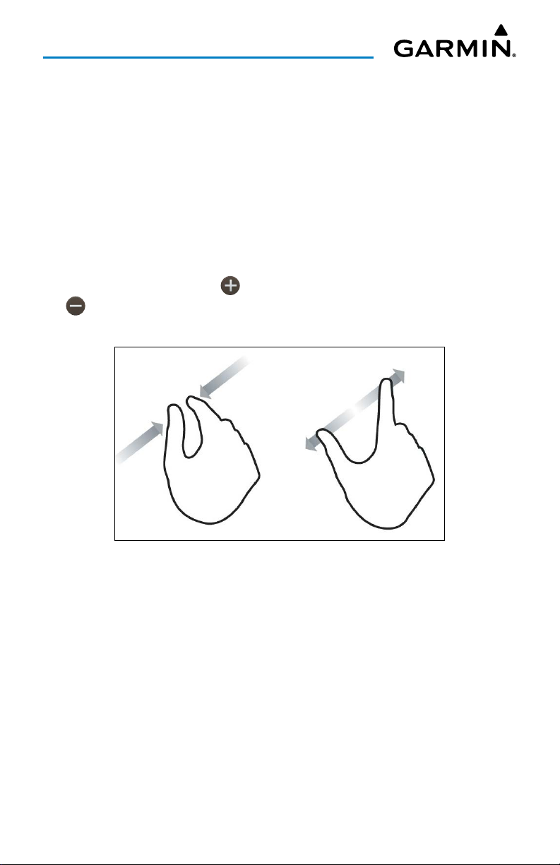
Also like other applications that use maps, panning is done by “touch-dragging” a
finger across the display, and magnifying or zooming is done by double-touching the
display, by pinching, or use the button. Reversing the pinch gesture or touching
the will de-magnify or zoom out. Additionally, double-touching the screen will
increase magnification in 50% intervals and center the map over the area tapped.
Pinch Zoom
Garmin Pilot for Android User’s Guide190-01532-00 Rev. U 4
Page 19
Overview
Garmin Pilot can be used in either portrait or landscape orientation and will respond
to the Android's automatic orientation feature. The map may be displayed in either
full screen or split screen in either orientation. The lower half of the display in portrait
orientation or second (non-map) display in landscape orientation has the following
functions; Widgets, Panel, Charts, SafeTaxi, Traffic, VIRB, Terrain, Checklist, or Synthetic
Vision.
To streamline navigation throughout the app, Garmin Pilot now offers a Tab Bar at
the bottom of the screen, which may be used as an alternative to the Home Screen
Main Menu.
Displaying Tab Bar:
1)
Touch Settings > General.
2)
Touch Tab Bar to adjust the Interface Style. Tap Classic to return to the
legacy Home Screen Menu interface style.
• Panel Mode is customizable and can be configured to display an instrument panel
with virtual instruments to indicate GPS altitude, ground speed, vertical speed,
course, and lateral deviation as well as a table with multiple configurable data
fields for monitoring navigation data.
• Widget Mode enables a series of customizable data windows called ‘Widgets’ to
be displayed. Widgets offer quick access to a variety of aviation weather products
(METARs, TAFs, Winds Aloft, NOTAMs, etc…) for nearby or selected airports.
Charts, SafeTaxi, Traffic when viewed in split-screen, have the same function,
navigation, and capabilities as the full screen versions of these products, just displayed
in half screen. Garmin Pilot requires a data connection for downloading maps and
other data prior to departure, but once everything needed for the flight is downloaded,
it is ready to navigate. The Downloads Menu in the Garmin Pilot settings options will
indicate when new downloadable data products are available upon connection to the
Internet.
NOTE:
With some of their newer devices, Android is moving away from buttons,
both physical or virtual, and replacing their functionality with gesture-based
navigation by default. Navigating within Garmin Pilot will differ accordingly
througout depending on your device settings.
Garmin Pilot for Android User’s Guide190-01532-00 Rev. U 5
Page 20
Overview
GETTING STARTED
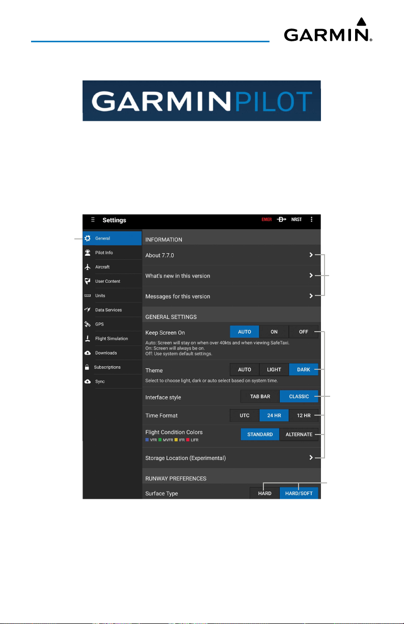
Garmin Pilot is fully functional immediately upon installation, but there are a few
things that can be set up in order to optimize performance right away. The best place
to start is with the highly intuitive Settings Menu, which can be found by momentarily
touching the Home Button and then the Settings Icon. The Settings Menu is always
available from the Home Button.
Touch Tab
to View Info
Touch to View
Revision Info
Touch to
Adjust General
Settings
Touch to
Adjust Runway
Preferences
Settings - General
Garmin Pilot for Android User’s Guide190-01532-00 Rev. U 6
Page 21
Overview
From the Settings Menu it is possible to set up or change the time format, input
pilot profile and aircraft information, manage user waypoints, set up the preferred
flight plan filing service, manage data subscriptions and much more. All of these and
more selections are available by touching the tab associated with the desired function.
The show/hide features like the Navigation Information (on the map display) can be
accessed in the Map Context Menu ( ) located in the upper right of the navigation
bar.
HELP FILE
The content of the User's Guide is mirrored in the in-app help file providing context
sensitive instructions for getting the most out of a Garmin Pilot subscription. The help
file can be accessed from any page, by touching the Map Context Menu ( ) located in
the Navigation Bar and then touching
the Help file can be accessed from the Home Button ( ) as well. Navigating within the
Help File is as easy as touching any of the hyperlinks.
Accessing the Help File:
Touch
Menu
>
Help
. The Help File will open to context sensitive content.
Help
in the page sensitive menu. Alternatively,
USER'S GUIDE
The Full Manual is a PDF formatted User's Guide for Garmin Pilot. The first time the
file is accessed, the device will ask to choose a default PDF viewer. The Full Manual has
a linked table of contents, index, and Bookmarks for easy navigation. The Full manual
can also be downloaded from www.garmin.com.
NOTE:
Bookmarks or Page Slider to quickly navigate the file.
The Full Manual will open to the most recently accessed page. Use the
Garmin Pilot for Android User’s Guide190-01532-00 Rev. U 7
Page 22
Overview
Accessing the Full Manual:
1)
Touch
Menu
>
Help
.
2)
Touch
Download
to download, touch
View
, to view the manual once
downloaded. Anytime an updated manual is available the View button will
revert to a Download button.
Accessing the Full Manual at www.garmin.com:
1)
Open www.garmin.com in a web browser.
2)
In the top right corner of the page hover the pointer over
3)
Select
Aviation Support
4)
Scroll down and select
5)
Type "Pilot" into the
6)
From the next drop down menu select
7)
Select the desired User's Guide to download, i.e. Garmin Pilot for Android
.
Aviation Manuals.
.
Enter a Product Name or Serial Number
Garmin Pilot™
Support
.
.
search bar.
User's Guide.
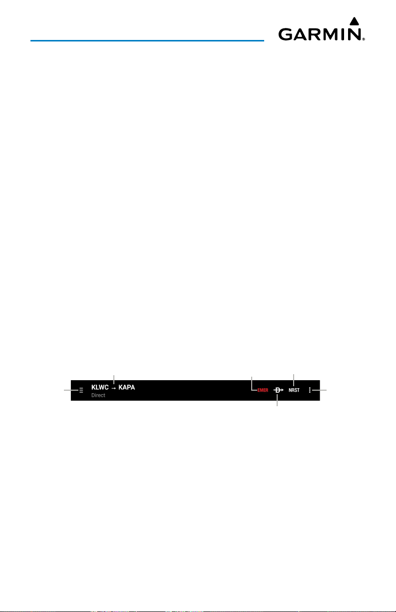
NAVIGATION BAR
Garmin Pilot's user interface is comprised of icons and active areas that provide
access to the various features and functions of the application. The Navigation Bar,
located at the top of every page, provides access to many of the basic functions.
Home &
Tools Button
Active
Flight Plan
Navigation Bar
Garmin Pilot for Android User’s Guide190-01532-00 Rev. U 8
Emergency
Direct To
Nearest
Page Sensitive
Menu Button
Page 23
Overview
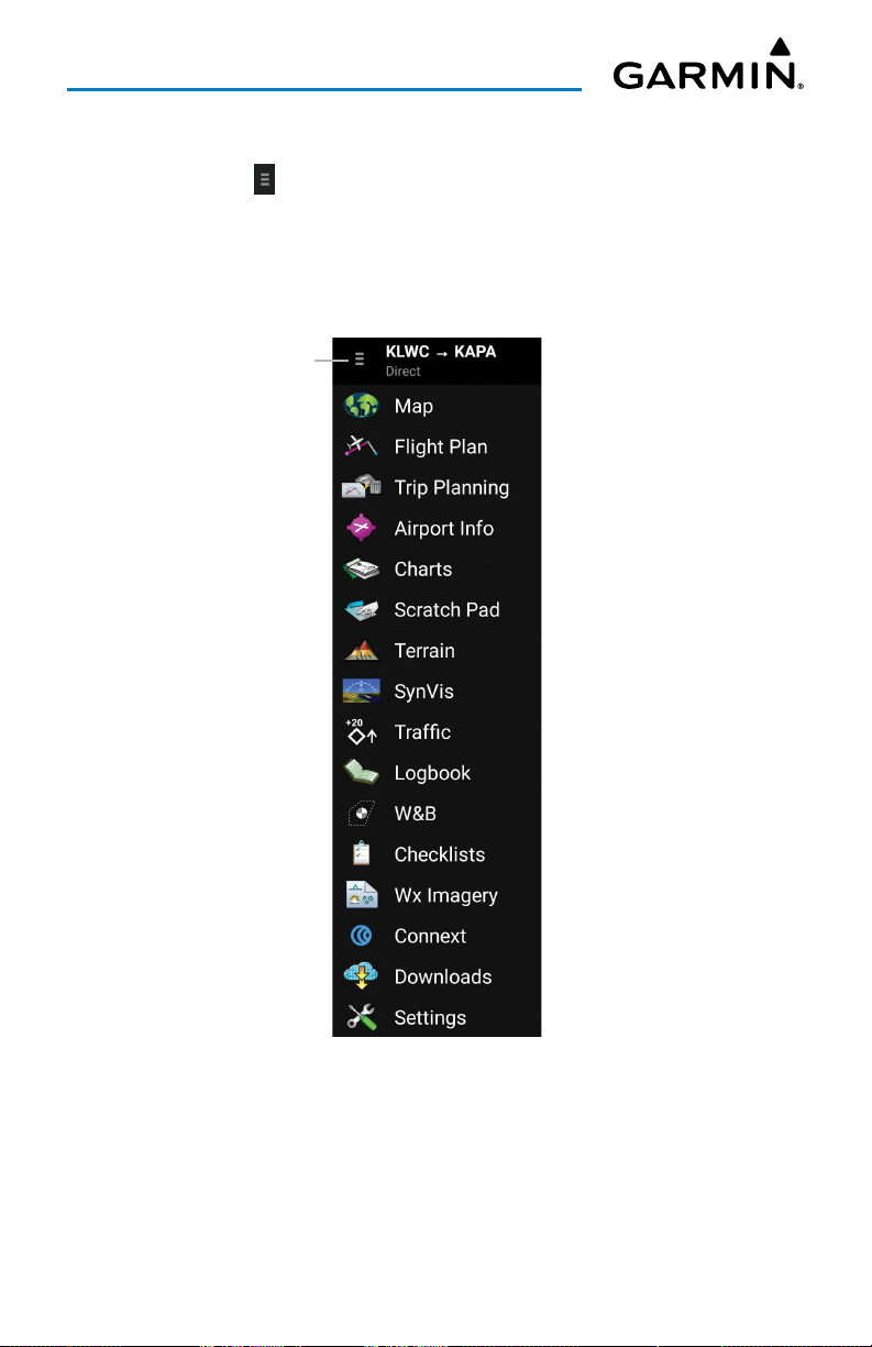
HOME BUTTON
The Home Button ( ) is the primary means of accessing many of the features of
Garmin Pilot. The Home Button provides quick access to the various pages within
Garmin Pilot (i.e., Map, Active Flight Plan, Trip Planning, Airport Information, Charts,
Scratch Pad, Terrain, Syn Vis, Traffic, Logbook, W&B, Checklists, Wx Imagery, Connext,
Downloads, & Settings).
Home Button
Home Menu
Garmin Pilot for Android User’s Guide190-01532-00 Rev. U 9
Page 24
Overview
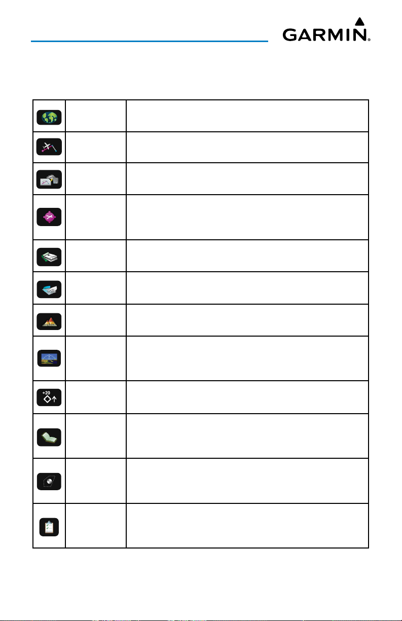
HOME BUTTON ICONS
Touch the following icon to display the associated function:
Map
Flight Plan
Trip Planning
Airport Info
Charts
Scratch Pad
Terrain
Synthetic
Vision
Traffic Displays the Dedicated Traffic Page.
Displays the Map Page, which provides full en-route
navigation capabilities on a moving map.
Displays the Active Flight Plan Page, where flight plans can
be created, stored, shared, modified, and reversed.
Displays the Trip Planning Page, which manages all of the trip
planning details for each trip.
Displays the Airport Information Page, which includes basic
airport info, frequencies, runways, procedures, weather,
NOTAM's, FBO's, fuel prices/fees, FAA remarks, & Nav Aids.
Displays the Charts Page, where various navigational charts
can be viewed when properly downloaded.
Displays the Scratch Pad Page, which allows the pilot to
quickly draw or write down information on the device screen.
Displays the Terrain View, which displays altitudes of terrain
and obstructions relative to the aircraft position and altitude.
Displays the Synthetic Vision View, which depicts a forwardlooking attitude display of the topography immediately in
front of the aircraft.
Logbook
Weight &
Balance
Checklists
Displays the Logbook Page, which allows the pilot to record
pertinent flight information such as currency, endorsements,
and photos.
Displays the Weight & Balance, which is calculated to
determine if the airplane is properly loaded within CG limits.
Displays the Checklists Page where specific aircraft electronic
checklists can be viewed to ensure proper flight procedures.
Garmin Pilot for Android User’s Guide190-01532-00 Rev. U 10
Page 25
Overview
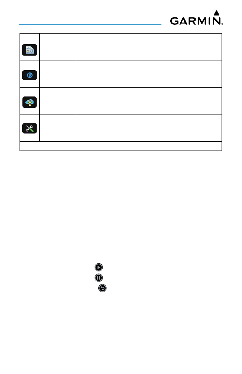
Displays the Weather Imagery Page, providing various
WX Imagery
meteorological data for both real-time and forecast weather
events.
Displays the Connext Page, which allows the wireless sharing
Connext
of data between devices via Bluetooth®, or, if properly
equipped, Wi-Fi.
Displays the Downloads Page, which automatically
Downloads
downloads file updates and next cycles as they become
available.
Displays the Settings Page, which includes General, Pilot
Settings
Info, Aircraft, User Waypoints, Units, Weather Data, GPS,
Downloads, Subscrptions, & Sync.
Home Button Icons
TOOLS
The Tools options at the bottom of the Home menu provides access to Demo Mode,
Stopwatch, Lock Screen option, Full Screen option, Brightness options, Alerts, and the
Help file.
Stopwatch
The Stopwatch feature changes the title bar to display a standard stopwatch,
showing hours, minutes and seconds.
Using the Stopwatch:
1)
Touch
Home
>
2)
Touch the
3)
Touch the
4)
Touch the
5)
Touch
to normal display.
Stopwatch
Start/Pause
Start/Pause
Reset button
Home
>
Stopwatch
Garmin Pilot for Android User’s Guide190-01532-00 Rev. U 11
.
button to start the timer.
button again to pause the timer.
at any time to reset the timer to zero.
to disable the stopwatch and return the title bar
Page 26
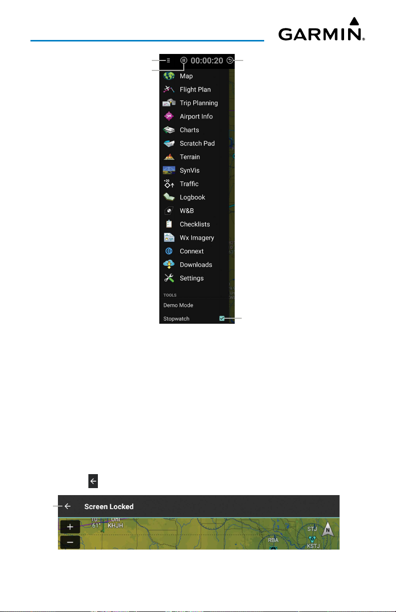
Overview
Home Button
Start/Pause Button
Reset Button
Touch to Enable
Stopwatch
Stopwatch Features
Lock Screen
The Lock Screen feature keeps the current map or chart from moving in case the
screen is accidentally touched while displaying important information.
Locking the Screen:
1)
Touch
Home
>
2)
Touch to
Unlock
Screen
Lock Screen
is locked. A 'Screen Locked' message is displayed if the map or chart is
swiped.
Touch to unlock the screen and return to normal function.
Garmin Pilot for Android User’s Guide190-01532-00 Rev. U 12
. The title bar turns gray to show the screen
Locked Map Screen
Page 27

Overview
FuLL Screen
The Home Menu provides access to the Full Screen mode. Simply touch Home >
Full Screen to activate.
Full Screen Mode Actions
1)
Swipe down from the top of the screen to view navigation controls.
2)
Swipe in from the left to open the Home Menu.
3)
To exit Full Screen Mode, swipe in from the left to open the Home Menu
and un-check the box next to Full Screen Mode.
BrightneSS
The Home Menu provides access to the display brightness control. Simply touch
Home
>
Brightness
brightness. Move the slider to the right to increase display brightness or left to
decrease brightness.
to display a display brightness slider and set the desired display
Touch to View
Device Settings
Slide to Adjust
Brightness
Touch to
Change Theme
Brightness Slider
NOTE:
may require disabling the "Automatic brightness" setting for the system
brightness.
To enable the in application brightness settings some Android devices
Garmin Pilot for Android User’s Guide190-01532-00 Rev. U 13
Page 28
Overview
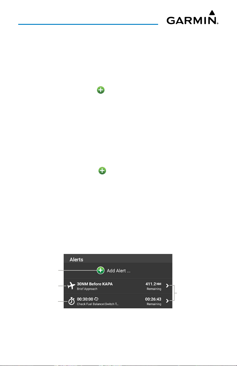
aLertS
Create Alerts based on time or location. Alerts that are based on time, can range
from 10 seconds to several hours. Time alerts can also be set to repeat. Location
based Alerts can be set At, Before, or After a Flight Plan Waypoint.
Creating a time based alert:
1)
Touch
Home
>
Alerts
>
Add Alert
2)
Touch
Time
>
Tap to Set
3)
Enter the desired count down time (HH:MM:SS).
4)
If desired, use the Repeating
5)
If desired, touch the
.
On/Off
Alert Message (Optional)
to enter a custom message.
6)
Touch
Save
.
Creating a location based alert:
1)
Touch
Home
>
Alerts
2)
Touch
3)
Touch the
4)
Touch the
Location
.
Relationship
Distance
>
field, and use the keypad to set the desired distance in
Add Alert
field and select
nautical miles.
5)
Touch the
6)
If desired, touch the
Waypoint
field, and select the desired waypoint from the list.
Alert Message (Optional)
to enter a custom message.
7)
Touch
Save
.
.
switch, to enable/disable repeating.
button and use the keypad
.
Before, At
, or
After
.
button, and use the keypad
Touch to
Add Alert
Distance Alert
Repeating
Time Alert
Touch to
View Details
Alerts - Main
Garmin Pilot for Android User’s Guide190-01532-00 Rev. U 14
Page 29
Overview
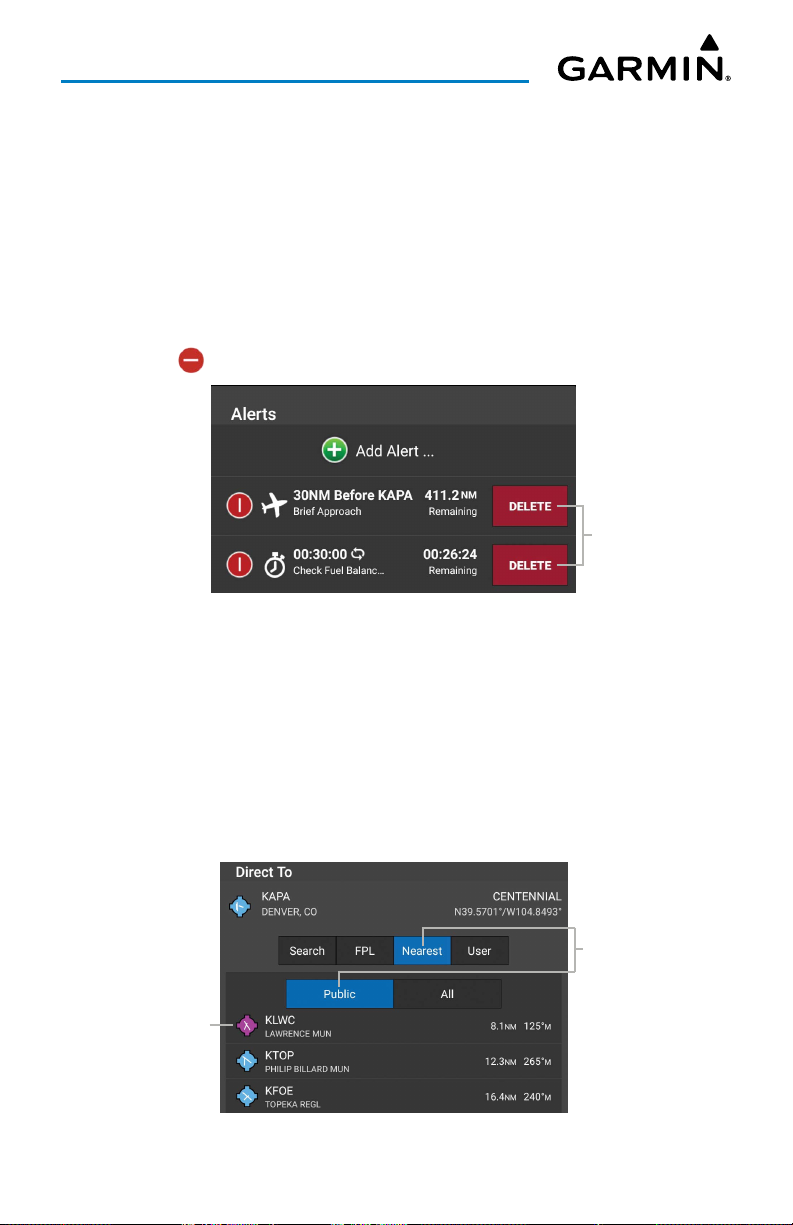
Editing Alerts:
1)
Touch
2)
Touch the desired alert for the list.
3)
Touch the desired field(s) to edit.
4)
Touch
Deleting Alerts:
1)
Touch
2)
Touch >
Home
>
Alerts
Save
, to save changes.
Home
>
Alerts
Delete
>
Edit
.
>
Edit
.
to delete the Alert.
Deleting Alert
Touch to
Delete
DIRECT-TO
The Direct-To button can be accessed from any page, and provides a quick and easy
way to navigate direct to any waypoint (i.e., Flight Plan Waypoint, Nearest Waypoints,
or User Waypoints). When Direct-To is active, the user can cancel Direct-To or reactivate Direct-To at any time. Re-activating Direct-To will calculate the direct to from
the current position.
Touch to
Filter Info
Touch to Select
Direct-to Dialogue
Garmin Pilot for Android User’s Guide190-01532-00 Rev. U 15
Page 30
Overview
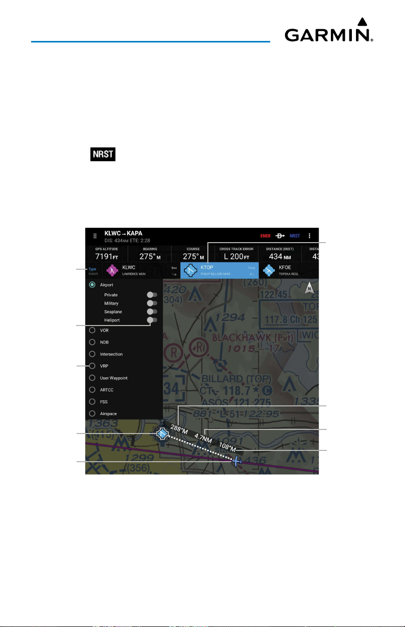
NEAREST
The nearest navigation button located on the top menu bar can be accessed from
any page, and provides a quick and easy way to locate airports, NAVAIDs, Intersection,
User Waypoint, ARTCC, FSS, and Airspace.
Displaying the nearest airport:
1)
Touch >
2)
If including in nearest search, touch to toggle the
Seaplane
3)
Touch once to select the Nearest Airport from the list, and touch again to
display the airport information.
Touch to View
Touch to
Display
, or
Heliport
Type
>
Airport
.
switches ON/OFF, as desired.
Private, Military
Touch to
View Info
,
Touch to
Change
NRST Type
Current
Selection
Current
Location
Heading
To NRST
Distance
To NRST
Heading
From NRST
Nearest Airports
Garmin Pilot for Android User’s Guide190-01532-00 Rev. U 16
Page 31
Overview
Displaying Nearest VOR, NDB, Intersection, VRP, or User Waypoint:
1)
Touch >
2)
Touch
VOR, NDB, Intersection, VRP
3)
Touch the nearest 'VOR', 'NDB', 'Intersection', 'VRP', or 'User Waypoint'
Type
.
, or
User Waypoint
.
from the list to display the navigation information.
Displaying Nearest ARTCC or FSS:
1)
Touch >
2)
Touch
ARTCC
3)
Touch the nearest 'ARTCC' or 'FSS' from the list.
4)
Touch again to display additional information.
or
Type
FSS
.
.
Displaying Nearest Airspace:
1)
Touch >
2)
Touch
Airspace
3)
Touch the nearest 'Airspace' from the list.
4)
Touch again to display additional information.
Type
.
.
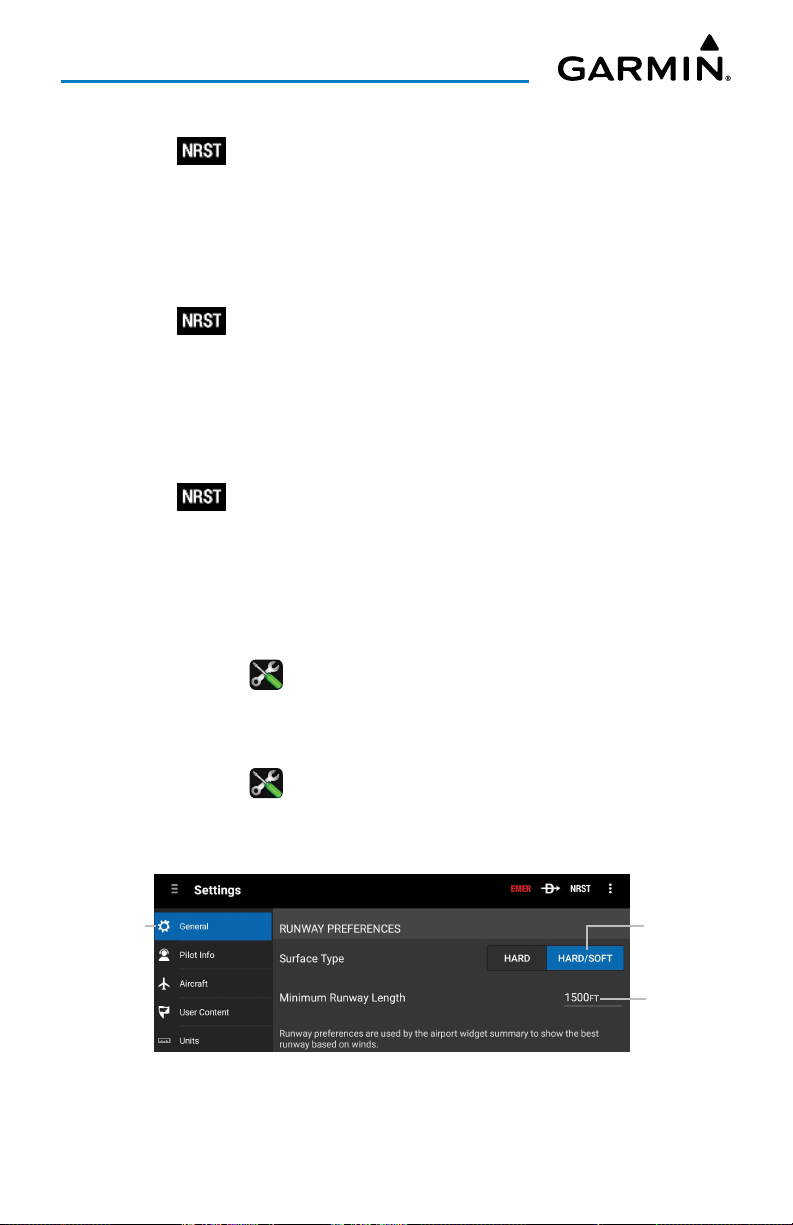
Setting Nearest Airport Runway Surface Type:
1)
Touch
Home
2)
Touch
Hard
> >
, or
General
Hard/Soft
.
in the Runway Surface Type field.
Setting the nearest airport minimum runway length:
1)
Touch
Home
> >
2)
Touch the Minimum Runway Length field to enter a value.
Touch
to View
General
Settings - Runway Preferences
Garmin Pilot for Android User’s Guide190-01532-00 Rev. U 17
.
Touch to Select
Touch to
Enter Info
Page 32
Overview
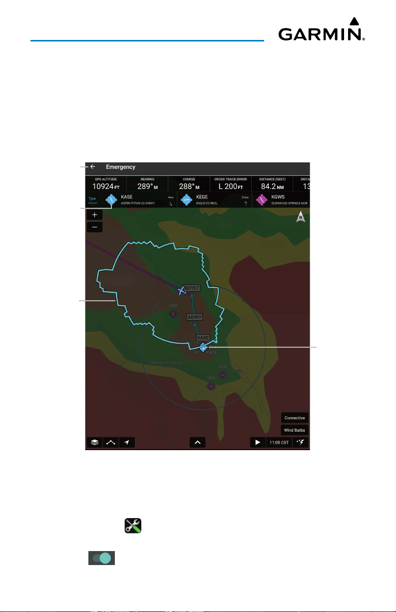
EMERGENCY MODE
The red Emergency (EMER) button located on the Navigation Bar can be accessed
from any page and proveds a quick way to reduce the pilot's workload in an emergency
situation. The EMER button will display the following:
• The Glide Range Ring using terrain and winds aloft data.
• The Emergency checklist in split screen mode if configured.
Touch Exit
'EMER'
Touch to View
Distance &
Direction
to Airport
Glide Range
Ring
Nearest
Airport
Emergency Mode (EMER) - Glide Range Ring
The EMER button can be configured to be displayed only when in flight.
Setting the EMER button to be displayed only when in flight:
1)
Touch
Home
> >
2)
Scroll to the
3)
Touch to toggle the
Emergency
General
.
section.
Hide EMER When Not Flying
Garmin Pilot for Android User’s Guide190-01532-00 Rev. U 18
button, as desired.
Page 33
Overview
MENU
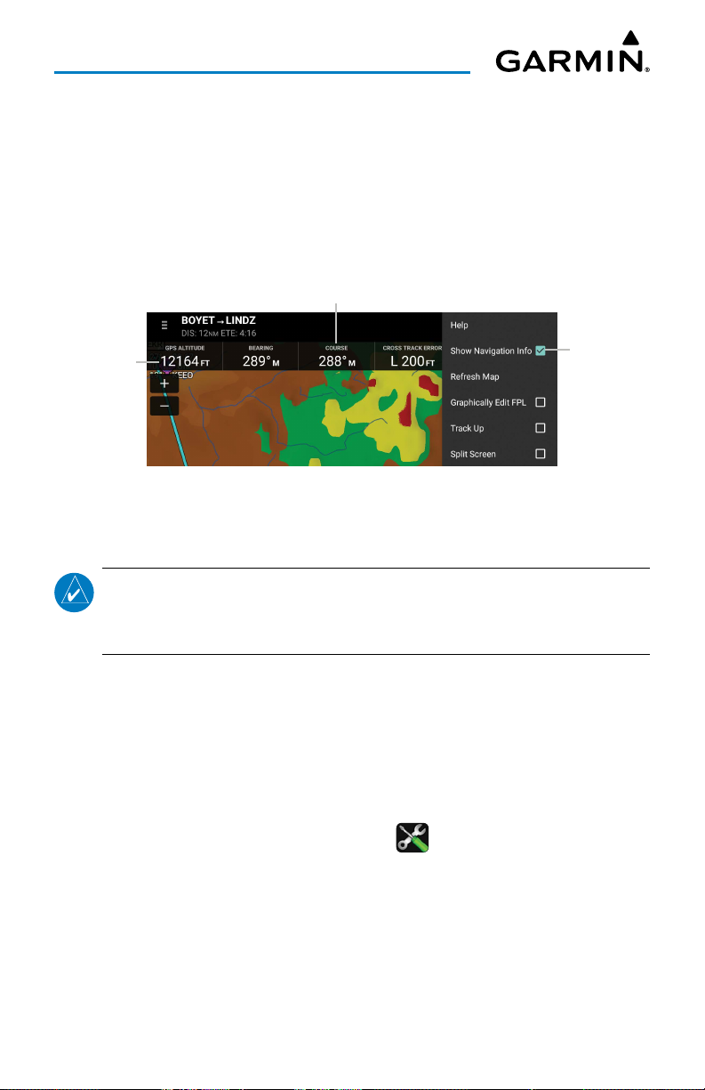
The Menu Button provides a page-sensitive menu structure. Each page has specific
menu options that control, search, navigate, or display page-sensitive menu items.
For example, the data bar fields can be displayed on the Map Page by touching the
'Show Navigation Info' checkbox. Touch each data field to change the navigation data
displayed.
Touch to Change
Data Field
Touch to
Navigation
Data
Displayed
Map Page Menu (Navigation Data Displayed)
Display
Navigation
Data
GLIDE RANGE RING
NOTE:
premium subscription, an updated terrain database downloaded, and the Glide
Ratio setting toggled 'On' for the selected Aircraft in the active Flight Plan.
To enable the Glide Range Ring on the Map, the User must have a valid
This feature is an aid to estimate accessible airports and terrain if the aircraft were
forced into glide circumstances. The displayed ring updates in real time, derived from
the selected aircraft's altitude, speed, and performance details. Since Garmin Pilot
supports multiple aircraft, the Glide Range Ring refers to the current active flight plan
to determine which aircraft performance details to calculate the ring shape.
The Glide Range Ring requires glide performance details to be specified in Garmin
Pilot's settings. This is accessed through
Home
> >
Aircraft
. Touch on an aircraft
(not aircraft type) to edit its details, and scroll down to the Glide section to specify
the
Glide Ratio
and
Best Glide Speed
. Refer to the aircraft documentation for these
values.
Garmin Pilot for Android User’s Guide190-01532-00 Rev. U 19
Page 34
Overview
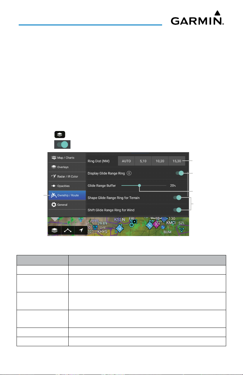
The
Glide Range Buffer
setting can be used to shrink the Glide Range Ring in
situations where glide performance is expected to be less than ideal, perhaps due to
shifting winds. Increasing this setting will decrease the size of the Glide Range Ring.
Enabling
Shape Glide Ring for Terrain
will alter the shape of the Glide Range Ring to
show intersection with terrain.
Enabling
Shift Glide Ring for Wind
will factor in local wind conditions when
calculating the Glide Range Ring shape. Note the Glide Range Ring uses the most
recent weather data, which may be outdated if Garmin Pilot does not have access to
real time weather data over Wi-Fi or with outboard hardware such as a GDL 39.
Enabling/Disabling the Glide Range Ring:
1)
Touch >
2)
Touch to toggle
Touch Tab to
View Info
Ownship/Route.
Display Glide Range Ring,
Glide Range Ring
as desired.
Select Ring(s)
Distance
Touch to Enable
Glide Range Ring
Slide to Adjust
Buffer
Touch to Adjust
Display
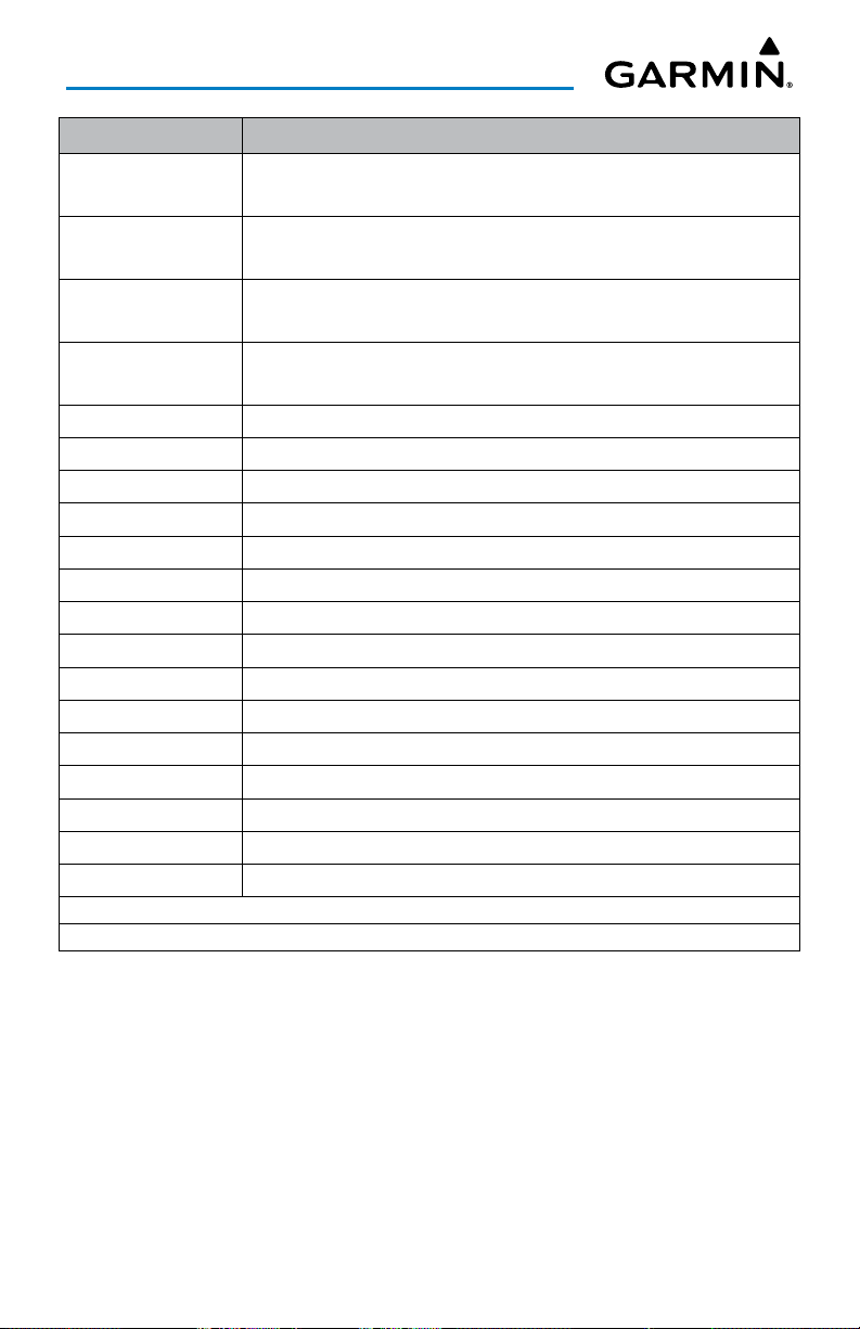
Navigation Data Description
Altitude The current GPS altitude or geometric height above MSL in feet.
Bearing
Course
Cross Track Error
The compass direction from the present position to a destination
waypoint.
The magnetic direction from the last waypoint to the active
waypoint.
The distance and direction, left or right, the aircraft is from the
desired course in nautical miles.
Distance (Dest) The distance to the destination waypoint in the Active Flight Plan
Distance (Next) The distance to the next waypoint in the Active Flight Plan.
Garmin Pilot for Android User’s Guide190-01532-00 Rev. U 20
Page 35
Overview
Navigation Data Description
ETA (Dest)
ETA (Next)
ETE (Dest)
ETE (Next)
The estimated time at which the aircraft should reach the
destination waypoint, based upon current speed and track.
The estimated time at which the aircraft should reach the next
waypoint, based upon current speed and track.
The estimated time it takes to reach the destination waypoint from
the present position, based upon current ground speed.
The estimated time it takes to reach the next waypoint form the
present position, based upon current ground speed.
Ground Speed The velocity the aircraft is traveling relative to the ground.
Heart Rate * Heart rate from a wrist or chest heart rate monitor.
Latitude Current latitude.
Longitude Current longitude.
Next Waypoint Next waypoint on the route of flight
Pitch Current pitch. (GDL 39 3D only)
Pulse Oximeter** Displays the saturation of oxygen in the blood
Roll Current roll. (GDL 39 3D only)
Time Current time
Track The direction of aircraft movement relative to the ground.
Vertical Speed The rate of climb or descent (GPS-derived).
Wx-Wind The wind speed/direction at the nearest weather reporting station.
Wx-Visibility The visibility at the nearest METAR reporting station
Wx-Altimeter The altimeter setting at the nearest METAR reporting station.
Wx-Ceiling The ceiling at the nearest METAR reporting station
*D2 Bravo Titanium, D2 Charlie series, and D2 Delta series.
**D2 Air, D2 Delta PX, MARQ® Aviator series.
Navigation Data Field Options
Garmin Pilot for Android User’s Guide190-01532-00 Rev. U 21
Page 36
Overview
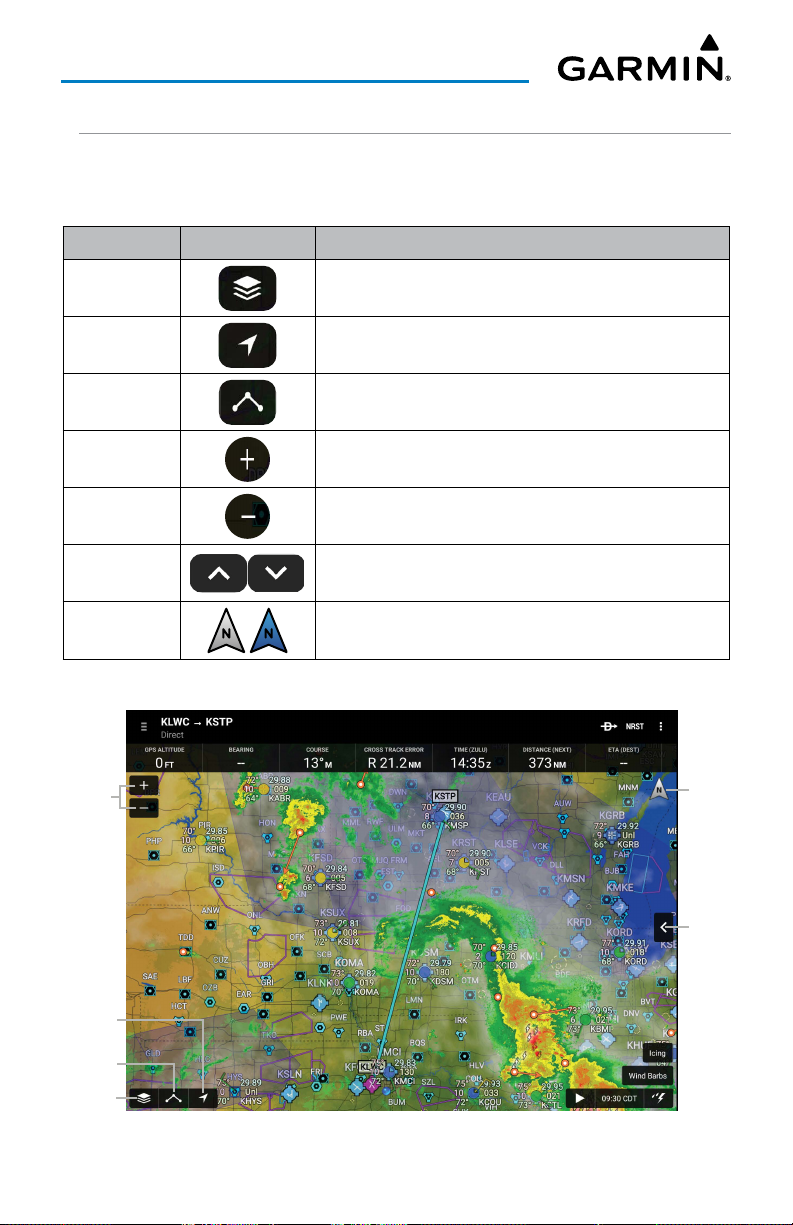
MAP PANE CONTROLS
The Map Pane has a number of buttons that control the Base Map, Map Overlays
and center map and split-screen. The table below shows the Map Pane Controls.
Control Icon Description
Map
Settings
Center on
Aircraft
Center on
Route
Zoom In Zooms In on the map
Zoom Out Zooms out on the map
Map/Chart Selection/Settings, Map Overlay Selection,
Overlay Opacity Settings, and General Map Settings
Centers the Map Pane on the current location.
Centers the entire route in Map Pane.
Split-Screen
Map
Orientation
Zoom In/Out
Center on
Aircraft
Center
on Route
Map Settings
Selects full screen map or partial map with Widgets,
Panel, Charts, and SafeTaxi.
Toggles map orientation from north up to track up.
The Icon is blue when track up is active.
Map Pane Controls
Map
Orientation
Split-Screen
Map Pane
Garmin Pilot for Android User’s Guide190-01532-00 Rev. U 22
Page 37
Overview
MAP/CHART SELECTION AND SETTINGS
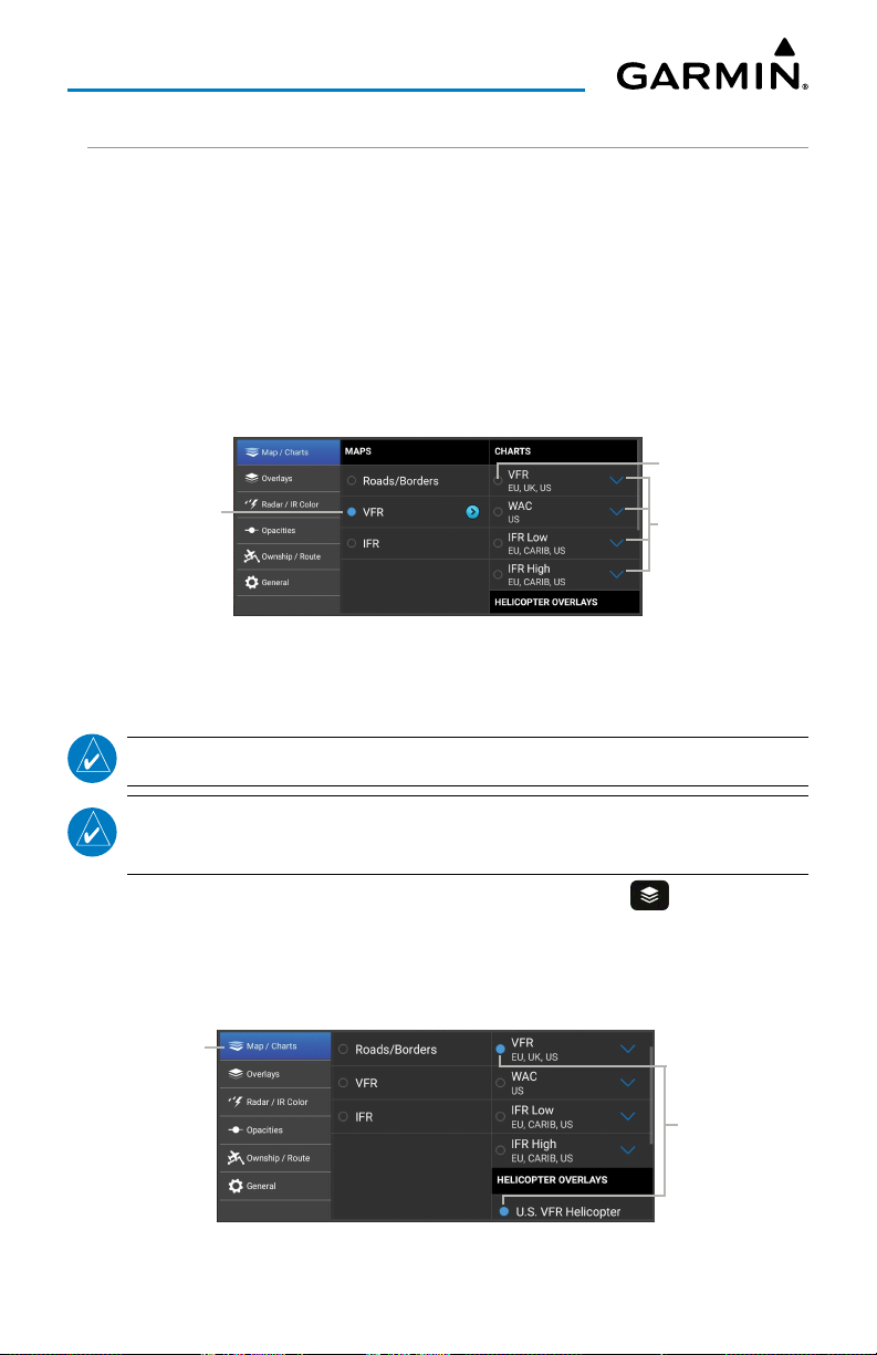
There are three maps and three charts available for display on the Map Page. The
following charts are available for viewing in the map area: Sectional TAC, IFR Low, and
IFR High. Charts are high-resolution color images that resemble the paper version of
the National Aeronautical Navigation Products (AeroNav) published charts. The Roads/
Borders Map is a very basic map showing major roads, bodies of water, boarders and
Flight Plan information. Both IFR and VFR maps are vector-based interactive maps
that are populated with aeronautical information such as airports, navigation aids,
maximum and minimum airspace altitudes, airspaces, and victor airways.
Touch to Display
Touch to Display
Map/Chart Menu
Selecting a Helicopter Chart Overlay:
NOTE:
NOTE:
A chart basemap must be selected to display helicopter overlays.
For information on downloading Helicopter Charts, refer to 'Downloads',
discussed later in this section.
1)
After downloading the desired Helicopter Charts, touch >
2)
Touch a chart basemap (
3)
Touch a Helicopter Overlay (
Gulf IFR Helicopter
Touch Tab
to View Info
VFR, IFR Low
).
, or
IFR High
U.S. VFR Helicopter, Gulf VFR Helicopter
).
Touch to Expand
Map/Chart.
, or
Touch to
Display
Selecting Helicopter Chart Overlay
Garmin Pilot for Android User’s Guide190-01532-00 Rev. U 23
Page 38
Overview
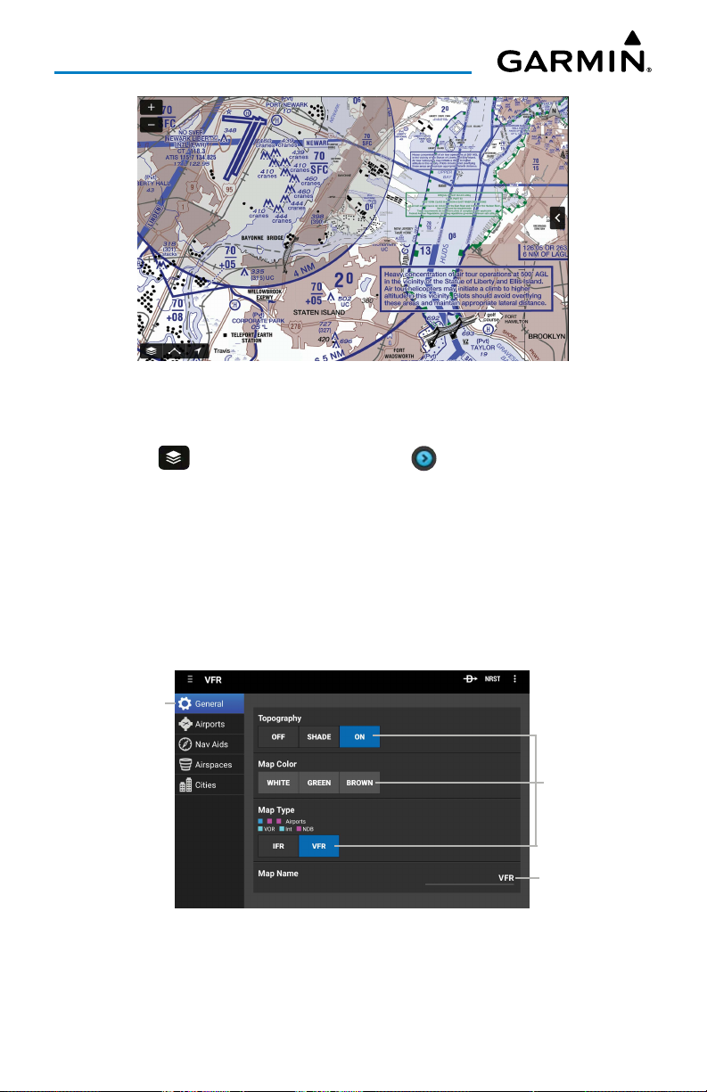
VFR Helicopter Chart Overlay
Accessing Advanced Map Settings:
1)
Touch >
2)
Touch
3)
Use the sliders and selection buttons to set Visibility Ranges and Label Sizes
Map/Chart
>
Map Name
General, Airports, Nav Aids, Airspaces, or Cities
for map features.
4)
To give the new settings a name, Touch
keyboard to enter a name.
5)
Touch
Done
to save and exit, or touch
default Map Theme setting.
> .
.
General > Map Name
Restore Defaults
to restore the
, and use the
Touch Tab
to View Info
Touch to
Display
Touch to
Enter Text
Advanced Map Settings - General
Garmin Pilot for Android User’s Guide190-01532-00 Rev. U 24
Page 39
Overview
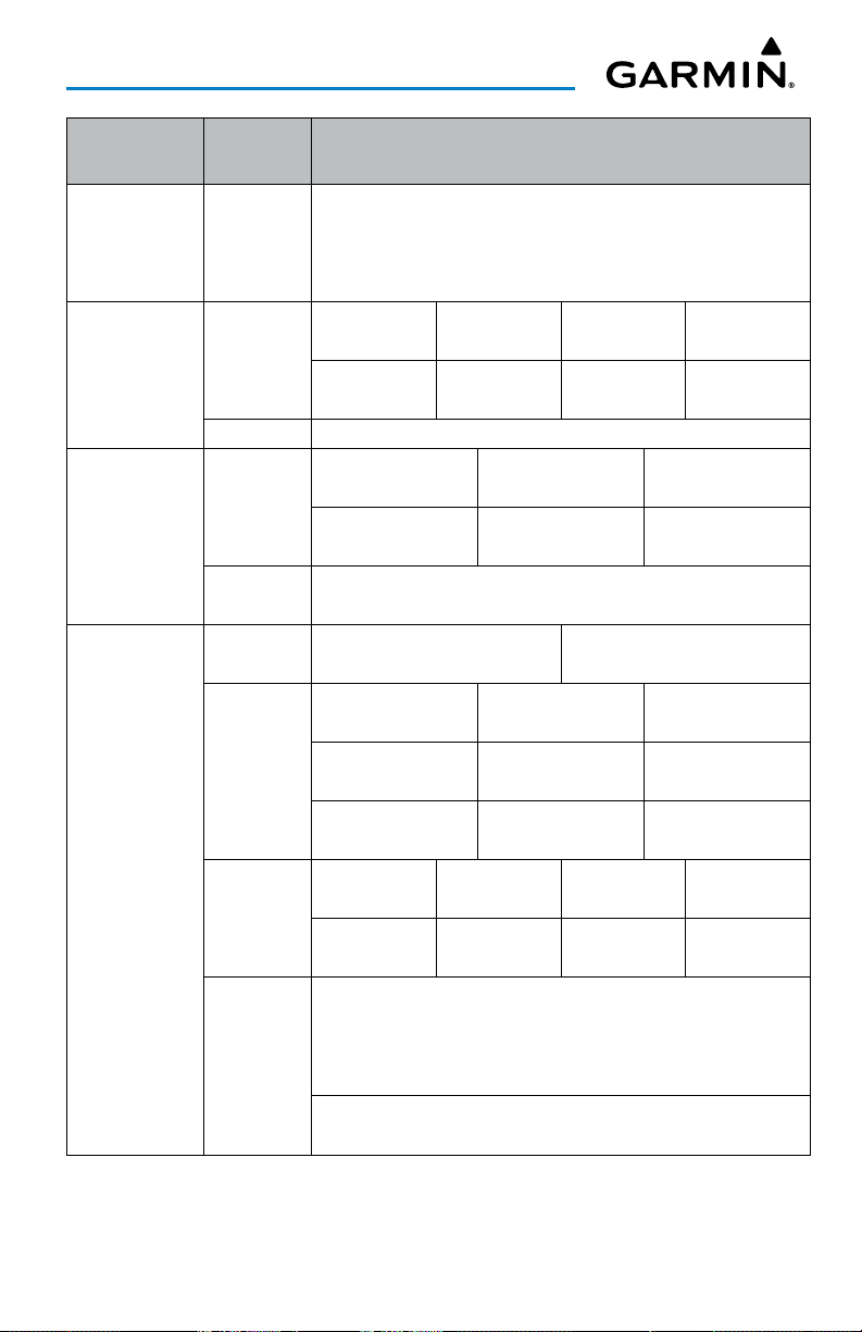
Map Setting
Categories
General
Airports
Nav Aids
Airspaces
Map Item Options
Topography Off, Shade, or On
Map Color White, Green, or Brown
Map Type IFR, or VFR
Map Name User Defined Name
Large Airports Med Airports Small Airports Pvt Airports
Visibility
Range
Label Size Off, Small, Medium, Large
Visibility
Range
Label Size
Filter All
Airspaces
Visibility
Range
SUA Visibility
Range
Label Style
Off - 200 nm Off - 50 nm Off - 20 nm Off - 20 nm
Heliports Seaplane Bases SafeTaxi
Off - 20 nm Off - 50 nm Off - 2 nm
VOR NDB Intersection
Off - 100 nm Off - 50 nm Off - 10 nm
VRP Low Airways High Airways
Off - 10 nm Off - 100 nm Off - 100 nm
VOR, NDB, Intersection, VRP
Off, Small, Medium, Large
Hide All Airspaces Above Smart Airspace
Numerical Entry On/Off
Class B Class C Class D
Off - 200 nm Off - 200 nm Off - 100 nm
Class E/TRSA TMA Control Area CTA
Off - 100 nm Off - 200 nm Off - 100 nm
Control Zone CTR ATZ/TIZ/MATZ Euro Airway
Off - 100 nm Off - 100 nm Off - 100 nm
Restricted Alert/Warning Parachute Area MOA
Off - 200 nm Off - 200 nm Off - 100 nm Off - 200 nm
ADIZ Danger Other
Off - 100 nm Off - 100 nm Off - 100 nm
Airspace Size
Off, Small, Medium, Large
Airspace Style
Standard, Enhanced
Airspace Color
Standard, Dark
Garmin Pilot for Android User’s Guide190-01532-00 Rev. U 25
Page 40
Overview
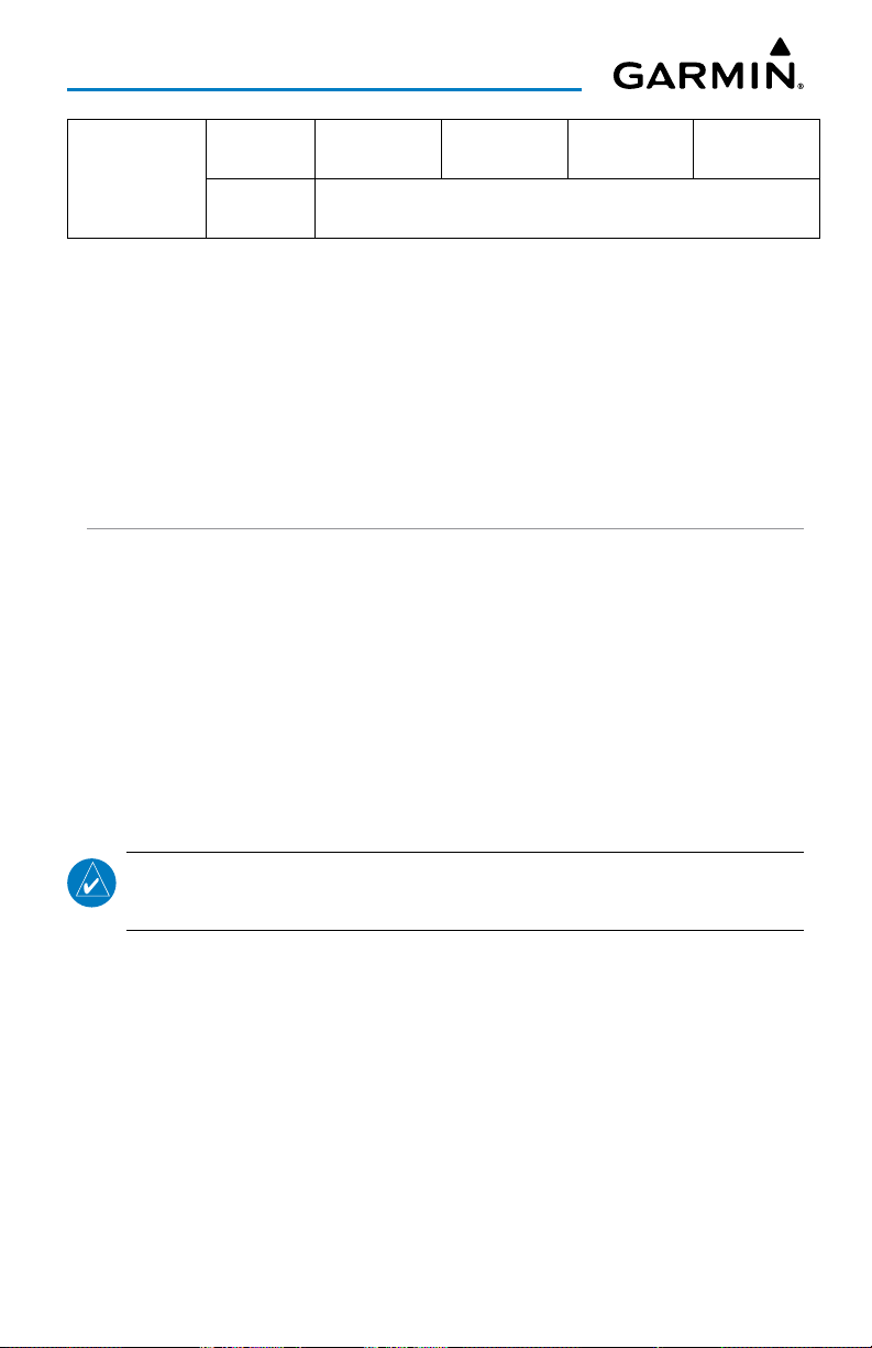
Large City Medium City Small City Small Town
Off - 500 nm Off - 200 nm Off - 100 nm Off - 50 nm
Large City, Medium City, Small City, Small Town
Off, Small, Medium, Large
Advanced Map Settings
Cities
Visibility
Range
Label Size
SETTINGS
Located under the Home Button, touch the Settings Icon to open the Settings Menu.
The Settings Menu tabs customize and manage Garmin Pilot features, subscriptions,
Pilot Info, Aircraft Info and much more.
GENERAL
The General Settings tab provides access to settings for Keep Screen On, Theme, Time
Format, Flight Condition Colors, Runway Preferences, Navigation, Altert Configuration
Setup, Alert Type Setup, Synthetic Vision, & General Data Protections Regulation
(GDPR). Touch
copyright information, and contact information (both email and phone) for Garmin
Aviation Support. Touch the email address to compose an email and send it directly to
Garmin Aviation Support. Sending a support email in this manner will automatically
populate the email with information that will greatly aid Garmin in troubleshooting
and resolving any issues that may arise.
About
to display the current version of the Garmin Pilot Application,
NOTE:
email.
Touch
A data connection (i.e., Wi-Fi or cellular) is required to send and receive
What's new in this version...
latest Garmin Pilot update.
Garmin Pilot for Android User’s Guide190-01532-00 Rev. U 26
to view information about what's new in the
Page 41
Overview
KEEP SCREEN ON
The Keep Screen On settings provide three options for controlling the device display
settings when using Garmin Pilot.
•
Auto
: The screen will stay on when the device GPS senses a ground speed over 40
kts and when viewing SafeTaxi
• On: The screen will always be on.
•
Off
: Uses the system default display settings.
Configuring Screen Settings:
1)
From any page, touch
2)
3)
Touch the
Touch
General
Auto, On
Home
> .
Tab.
or
Off
to select the desired Keep Screen On settings.
THEME
The provided alternate themes allow Garmin Pilot to be used in various lighting
scenarios. The
see during the day and in direct sunlight. The
background that's much more comfortable in low-light situations. The
automatically switch between the two based on the time of day.
Light
theme uses dark text on a bright background that's easier to
Dark
theme uses bright text on a dark
Auto
option will
Configuring Interface Themes:
1)
From any page, touch
2)
Touch the
3)
Touch
Or
1)
From any page, touch
2)
Touch
General
Auto, Light
Auto, Light
Home
> .
Tab.
or
Dark
to select the desired setting.
Home
>
or
Dark
to select the desired setting.
Garmin Pilot for Android User’s Guide190-01532-00 Rev. U 27
Brightness
.
Page 42
Overview
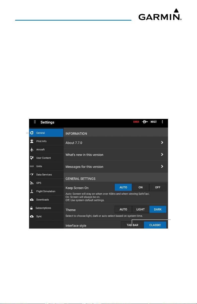
INTERFACE STYLE
The Tab Bar, located at the bottom of the screen, when selected, may be used as
an alternate means of accessing many of the features of Garmin Pilot. The Tab Bar
is configurable and provides quick access to the various pages within Garmin Pilot
(Map, Flight Plan, Trip Planning, Airport Info, Charts, Weather Imagery, Scratch Pad,
Terrain, Traffic, Checklists, Synthetic Vision, Logbook, Weight and Balance, Connext,
Downloads, & Settings).
Adjusting Interface Style:
1) Touch Settings > General.
2)
Touch Tab Bar to adjust the Interface Style.
3)
Touch Classic to return to the legacy Home Screen Menu interface style.
Touch to
View
Touch to
Select
Settings - General - Interface Style Selection
Garmin Pilot for Android User’s Guide190-01532-00 Rev. U 28
Page 43
Overview
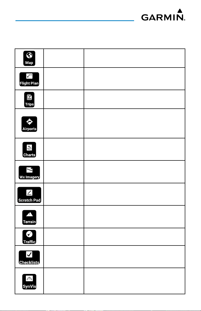
TAB BAR ICONS
Touch the following icon to display the associated function:
Map
Flight Plan
Trip Planning
Airport Info
Charts
WX Imagery
Scratch Pad
Terrain
Displays the Map Page, which provides full enroute navigation capabilities on a moving map.
Displays the Active Flight Plan Page, where flight
plans can be created, stored, shared, modified, and
reversed.
Displays the Trip Planning Page, which manages all
of the trip planning details for each trip.
Displays the Airport Information Page, which
includes basic airport info, frequencies, runways,
procedures, weather, NOTAM's, FBO's, fuel prices/
fees, FAA remarks, & Nav Aids.
Displays the Charts Page, where various
navigational charts can be viewed when properly
downloaded.
Displays the Weather Imagery Page, providing
various meteorological data for both real-time and
forecast weather events.
Displays the Scratch Pad Page, which allows the
pilot to quickly draw or write down information on
the device screen.
Displays the Terrain View, which displays altitudes
of terrain and obstructions relative to the aircraft
position and altitude.
Traffic Displays the Dedicated Traffic Page.
Displays the Checklists Page where specific aircraft
Checklists
Synthetic Vision
Garmin Pilot for Android User’s Guide190-01532-00 Rev. U 29
electronic checklists can be viewed to ensure
proper flight procedures.
Displays the Synthetic Vision View, which depicts a
forward-looking attitude display of the topography
immediately in front of the aircraft.
Page 44
Overview
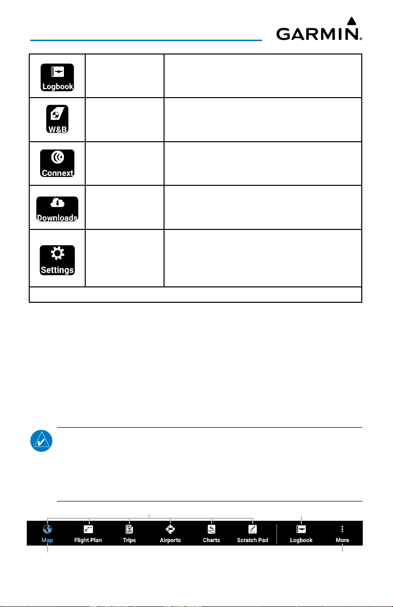
Logbook
Weight & Balance
Connext
Downloads
Settings
CUSTOMIZE TAB BAR ICONS
Displays the Logbook Page, which allows the pilot
to record pertinent flight information such as
currency, endorsements, & photos.
Displays the Weight & Balance, which is calculated
to determine if the airplane is properly loaded
within CG limits.
Displays the Connext Page, which allows the
wireless sharing of data between devices via
Bluetooth®, or, if properly equipped, Wi-Fi.
Displays the Downloads Page, which automatically
downloads file updates and next cycles as they
become available.
Displays the Settings Page, which includes General,
Pilot Info, Aircraft, User Content, Alerts, Units,
Downloads, Subscrptions, FltPlan.com, Jeppesen,
Documents, Data Services, & Flight Simulation.
Tab Bar Icons
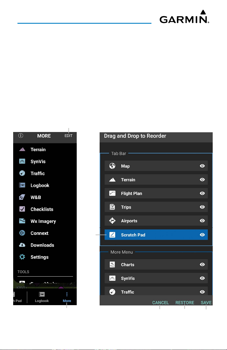
The More menu contains the items not visible in the tab bar, which may be reordered
or hidden from view. The order of the items in the tab bar may be customized by
clicking More > Edit. Long press the desired Tab Bar icon to start customizing, using
the drag-and-drop gesture to move icons to their desired location. The item to the right
of the horizontal line is dynamic and displays the most recently viewed feature from
the More menu.
NOTE:
the remaining space on the Tab Bar reserved for user selected items which is
dependent on screen size and device orientation. In the event a device only has
enough space to show three (3) tabs, no recent tabs will be shown, instead the
tabs shown will be two (2) user selected items and the More tab.
Current Page
The Tab Bar will show between zero (0) and three (3) recent tabs with
User Selected Icons
Tab Bar
Garmin Pilot for Android User’s Guide190-01532-00 Rev. U 30
Most Recent
Touch to View
Page 45
Overview
Customizing Tab Bar Icons:
1)
From anywhere in Garmin Pilot, touch More > Edit to display the Drag
and Drop to Reorder window.
2)
The Tab Bar and More Menu icons are displayed. Scroll down to view the
complete list of icons in the More Menu.
3)
Long press on the desired icon until the background is highlighted (blue),
then drag and drop the icon in the desried location.
4)
If necessary, touch Restore to load the previous selection and sequence of
icons.
5)
Touch Save to continue or Cancel to close without saving.
Touch to
Customize Tab Bar
Touch to View
Garmin Pilot for Android User’s Guide190-01532-00 Rev. U 31
Long Press
to Drag
& Drop
Tab Bar Customization
Touch to
Cancel
Touch to
Restore
Touch
to Save
Page 46
Overview
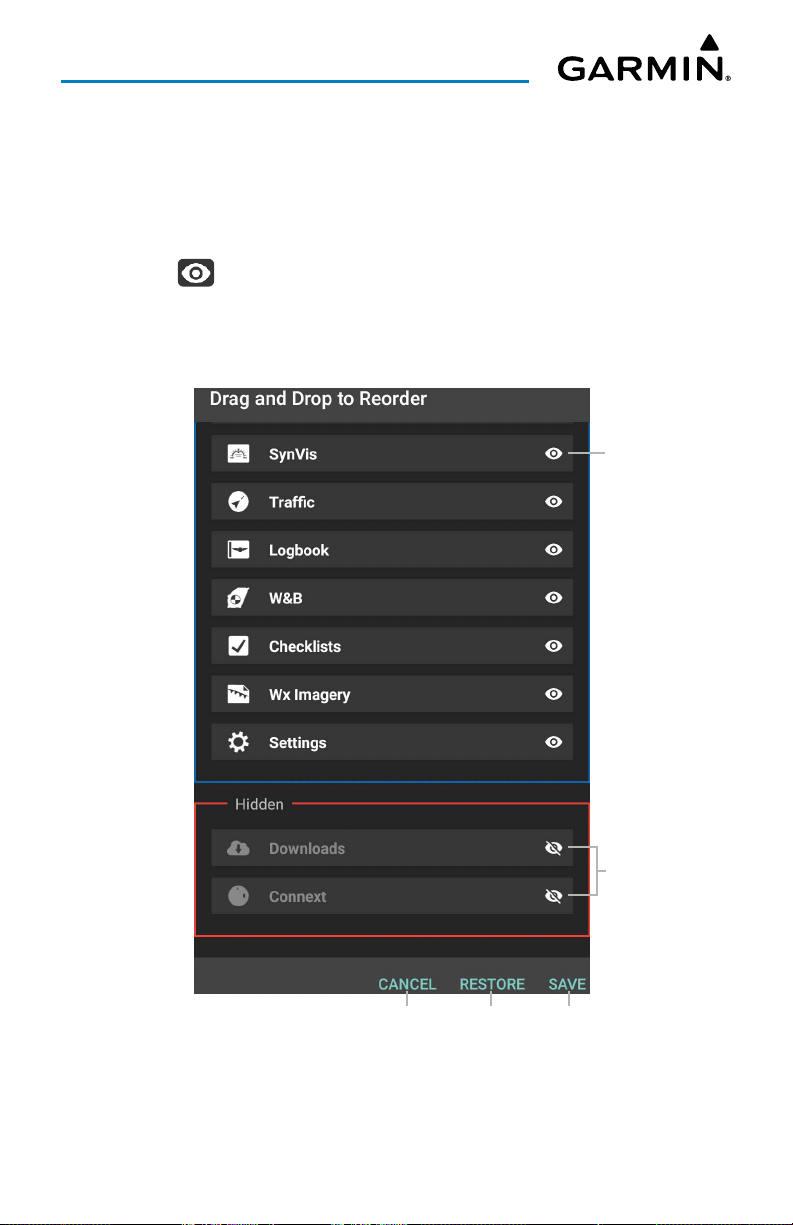
Hiding Tab Bar Icons:
1)
From anywhere in Garmin Pilot, touch More > Edit to display the Drag
and Drop to Reorder window.
2)
The Tab Bar and More Menu icons are displayed. Scroll down to view the
complete list of icons in the More Menu.
3)
Touch to Hide and remove from the available icon(s) on the Tab Bar.
4)
If necessary, touch Restore to unhide and load the previous selection and
sequence of icons.
5)
Touch Save to continue or Cancel to close without saving.
Touch to Hide
Hidden Icons
Touch to
Cancel
Tab Bar Customization - Hidden Icons
Garmin Pilot for Android User’s Guide190-01532-00 Rev. U 32
Touch to
Restore
Touch
to Save
Page 47
Overview
RUNWAY PREFERENCES
Setting Runway Preferences will adjust the Best Runway recommendations made by
the Airport Information page and the airport widget. The default
Soft which will recommend any runway. Changing this to Hard will only recommend
asphalt and concrete runways. Setting the
Minimum Runway Length
recommend runways to the specified length or greater.
Surface Type
will only
is Hard/
NOTE:
the best runway based on winds.
Runway preferences are used by the airport widget summary to show
OBSTACLES
Configuring Helicopter Obstacles:
1)
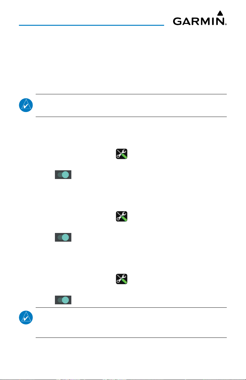
From any page, touch
2)
Touch the
3)
Touch to toggle
General
Home
> .
Tab.
Show Helicopter Obstacles
EMERGENCY
Configuring Hide EMER When Not Flying:
1)
From any page, touch
2)
Touch the
3)
Touch to toggle
General
Home
> .
Tab.
Hide EMER When Not Flying
NAVIGATION
Configuring Automatic Safe Taxi:
1)
From any page, touch
2)
Touch the
General
Tab.
Home
> .
as desired.
as desired.
3)
Touch to toggle
NOTE:
SafeTaxi will launch after landing at the destination airport when ground
speed drops below 40 kts.
With a SafeTaxi subscription and when Automatic SafeTaxi is On,
Automatic Safe Taxi
Garmin Pilot for Android User’s Guide190-01532-00 Rev. U 33
as desired.
Page 48
Overview
ALERT CONFIGURATION SETUP
The Alert Configuration Setup section allows the pilot the ability to toggle
Notifications On/Off for vibration settings as well as select a desired ringtone. When
Notifications are On, a Garmin Pilot Icon will appear in the device notification area (i.e.
the top banner) when the configured alert criteria is met (i.e., time or location).
Configuring Alert Notifications:
1)
From any page, touch
2)
Touch the
3)
Touch
audio notifications.
4)
Touch to toggle Vibrate as desired.
General
Notification Ringtone
Tab.
Home
> .
to select a ringtone, or set to
None
to disable
ALERT TYPE SETUP
Configuring Terrain Alerts:
1)
From any page, touch
2)
Touch the
3)
Touch to toggle
General
Home
Tab.
Terrain Alerts
> .
as desired.
Configuring Traffic Alerts (Traffic Device Required):
1)
From any page, touch
2)
Touch the
3)
Touch to toggle
General
Home
Tab.
Traffic Alerts
> .
as desired.
Configuring Audio:
1)
From any page, touch
2)
3)
Touch the
Touch
General
Audio
options
Home
> .
Tab.
OFF, MALE
Garmin Pilot for Android User’s Guide190-01532-00 Rev. U 34
, or
FEMALE
.
Page 49
Overview
Configuring Trip Weather Alerts:
1)
From any page, touch
2)
Touch the
3)
Touch to toggle
General
Home
Tab.
Trip Weather Alerts
> .
as desired.
NOTE:
Trip Weather Alerts are activated when weather for one or more trips
goes below minimums set by the User.
SYNTHETIC VISION
Configuring Roll Indication:
1)
From any page, touch
2)
3)
Touch the
Touch
General
Roll Indication
Home
Tab.
options
> .
SKY POINTER
, or
GROUND POINTER
.
GENERAL DATA PROTECTION REGULATION (GDPR)
The GDPR is a regulation in the European Union on data protection and privacy for
all individual citizens of the European Union and the European Economic Area. It also
addresses the transfer of personal data outside the EU and EEA areas. If applicable,
touch the
Reset
button.
Garmin Pilot for Android User’s Guide190-01532-00 Rev. U 35
Page 50
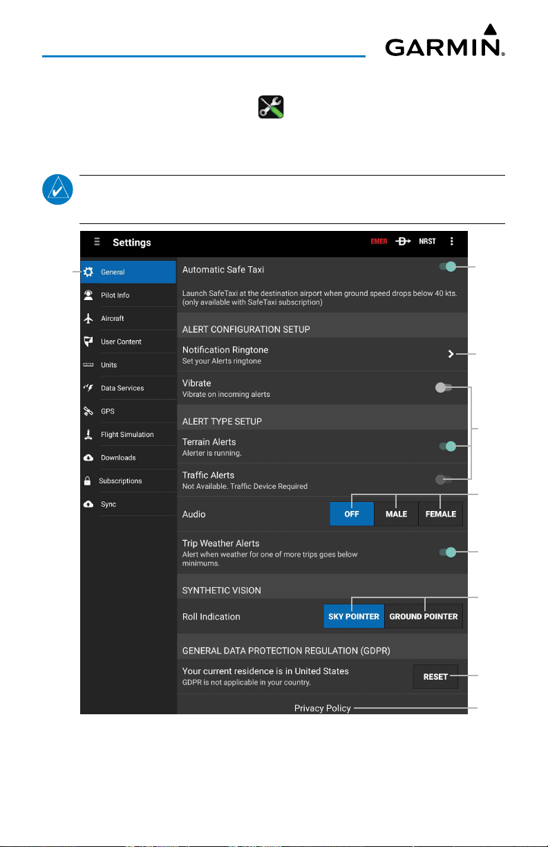
Overview
Resetting General Data Protection Regulation:
1)
From any page, touch
2)
Touch the
3)
Touch Reset button in the GDPR section, as desired.
General
Tab.
Home
> .
Touch to
View
NOTE:
For additional information, please visit https://eugdpr.org and/or click
on Privacy Policy button.
Touch to
Toggle
On/Off
Touch
to View
Touch to
Toggle
On/Off
Touch to
Select
Touch to
Toggle
On/Off
Touch to
Select
Touch
to Reset
Touch
Settings - General Cont'd
Garmin Pilot for Android User’s Guide190-01532-00 Rev. U 36
to View
Page 51
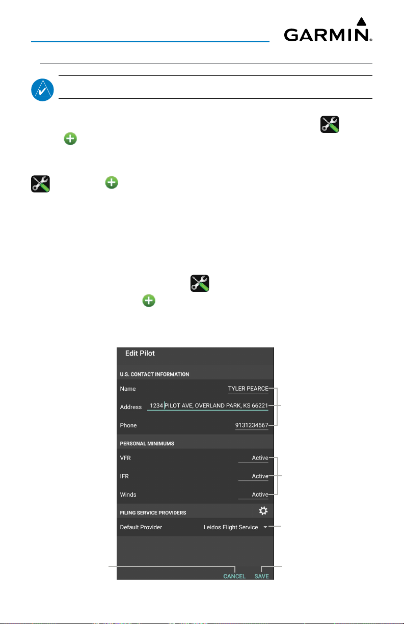
Overview
PILOT AND AIRCRAFT INFO
NOTE:
A data connection (i.e., Wi-Fi or cellular) is required to file flight plans.
If a Garmin Pilot account is already signed into the app, Pilot and Aircraft information
will automatically be synchronized. To add a new pilot touch
Info
>
Add Pilot Information...
. Touch in each field and use the on-screen
Home
> >
Pilot
keyboard to enter the requested information (i.e., Name, Address, Telephone, Personal
Minimums, and preferred Filing Service). Add aircraft information by touching
>
Aircraft
>
Add Aircraft...
, enter aircraft Identifier, Type, Equip Suffix, Home
Home
>
Base, Primary and Secondary Color, TAS, and Fuel information. To link Garmin Pilot
with a Filing Service Provider, under Pilot Information, enter username and password
information for the preferred provider. By linking to a Filing Service Provider, Garmin
Pilot can file flight plans.
Entering Pilot Information:
1)
From any page, touch
2)
Touch
Pilot Info
3)
Enter the Pilot Information by touching each field and use the keyboard.
4)
Touch
Save
, to save Pilot Information.
Home
> .
>
Add Pilot Information...
.
Touch to
Cancel
Touch
to Input
Contact
Info
Touch
to Input
Personal
Mins
Touch to
Select
Touch
to Save
Pilot Information Entry
Garmin Pilot for Android User’s Guide190-01532-00 Rev. U 37
Page 52
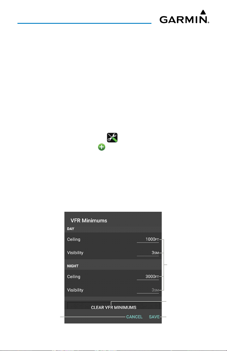
Overview
PERSONAL MINIMUMS
Each pilot that's registered on a Garmin Pilot account can specify personalized
parameters for VFR, IFR and Wind minimums. These settings are considered by the
Garmin Pilot app when planning trips.
Available parameters are:
• VFR minimums for ceiling and visibility for day and night flights
• IFR minimums for ceiling and visibility for day and night arrivals and departures
• Maximum wind speed, wind gusts, and crosswind component for arrival(s) and
departure(s)
Configuring Personal Minimums:
1)
From any page, touch
2)
Touch the
Or
: Touch a current Pilot in the list to edit.
3)
Touch
4)
Enter the preferred ceiling minimums in feet.
5)
Enter the preferred visibility minimums in statute miles.
6)
Enter the preferred maximum wind speeds in knots.
7)
Touch
Pilot Info
VFR, IFR
Save
.
or
Winds
Home
> .
Tab >
.
Add Pilot Information...
.
Touch to
Cancel
Touch to
Input Info
Touch to
Clear Info
Touch
to Save
Pilot - Personal Minimums - VFR
Garmin Pilot for Android User’s Guide190-01532-00 Rev. U 38
Page 53
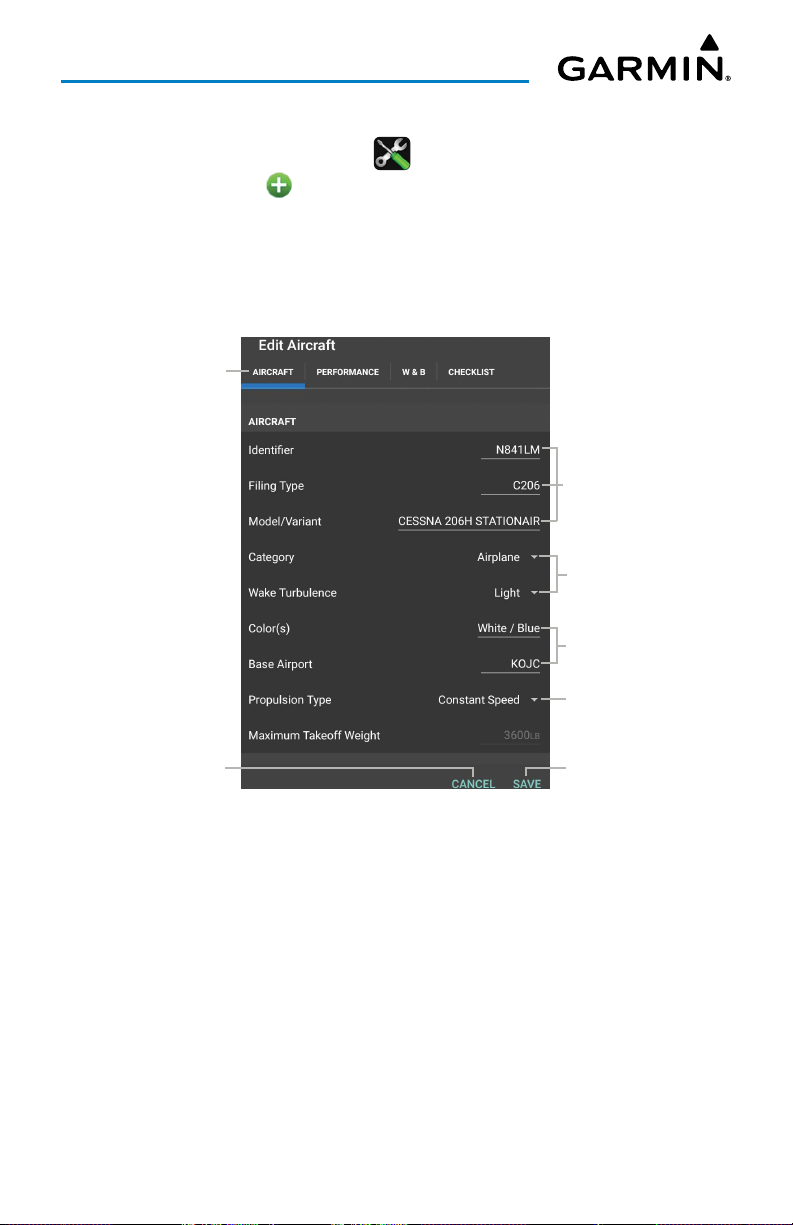
Overview
Entering Aircraft Information:
1)
From any page, touch
2)
Touch
Aircraft
Or
: Touch a current Aircraft in the list to edit.
3)
Enter Required and/or optional Aircraft Information by touching each field
>
Home
Add Aircraft...
and use the keyboard.
4)
Touch
Save
, to save Aircraft Information.
Touch
to View
> .
.
Touch
to Input
Info
Touch to
Select
Touch
to Input
Info
Touch to
Select
Touch to
Cancel
Touch
to Save
Aircraft Information Entry
Garmin Pilot for Android User’s Guide190-01532-00 Rev. U 39
Page 54
Overview
ATC PROPOSED ROUTE NOTIFICATIONS
ATC Proposed Route Notifications are Push notifications, that include a proposed
route for departures and destinations for previously filed flight plans. Notifications
come in the notification area if Garmin Pilot is not currently active, or as Pop-ups within
Garmin Pilot. To accept the proposed route and make it the Flight Plan, ensure Make
Flight Plan is set to On, and touch
notification and not make it the Flight Plan, ensure Make Flight Plan is set to
touch
Dismiss
Subscribing to ATC Proposed Route Notifications:
1)
2)
3)
Or
4)
5)
to remove the popup.
From any page, touch
Touch the
Touch
: Touch a current Aircraft in the list, to edit.
Scroll down & touch to
Touch
Aircraft
Add Aircraft
Save
, to save Aircraft Information.
Tab.
.
Brief
Home
to open the Trip Planning Page. To dismiss the
Off
, and
> .
Subscribe
to Proposed Route Notifications.
USER CONTENT
The User Content Tab provides a quick and easy way to create and view stored user
waypoints. User waypoints are synchronized across devices. When creating a new user
waypoint, Garmin Pilot provides three ways to specify the precise location.
If
Lat/Lon
is selected, Garmin Pilot can accept the coordinates in three formats:
degrees in decimal (hdd.dddd); degrees and minutes in decimal (hddd.mm.mmmmm');
and degrees, minutes and seconds in decimal (hddd.mm'ss.s").
Rad/Dist
can accept locations around a specified VOR station, using a radial and
distance.
Rad/Rad
can accept locations as the intersection of two radials of two different VOR
stations.
Garmin Pilot for Android User’s Guide190-01532-00 Rev. U 40
Page 55
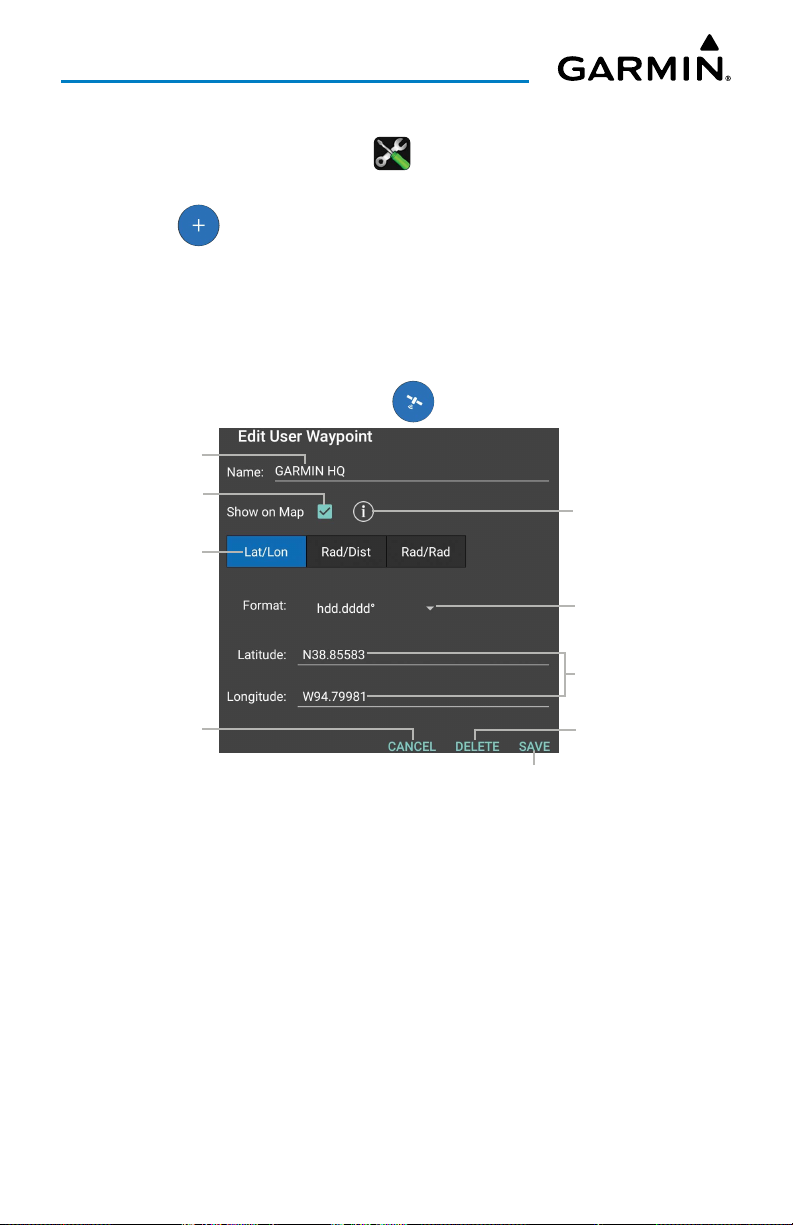
Overview
Creating/Editing a User Waypoint from User Content Tab:
1)
From any page, touch
2)
Touch the
3)
Touch button to display the
Or
: Touch a current User Waypoint in the list to edit.
4)
Enter a name.
5)
Define the waypoint location by Lat/Lon, Rad/Dist, or Rad/Rad.
6)
Touch
7)
If the waypoint was saved, touch button to view on Google Maps.
Touch to Edit
View on Map
Touch to Define
User Content
Save
Touch to
to save the waypoint, or
Home
Tab.
> .
New User Waypoint
Cancel
dialog box.
to exit.
Touch to
View Info
Touch to Select
Touch to Cancel
Touch to Adjust
Touch to
Clear Info
Touch to Save
Edit User Waypoint
Garmin Pilot for Android User’s Guide190-01532-00 Rev. U 41
Page 56
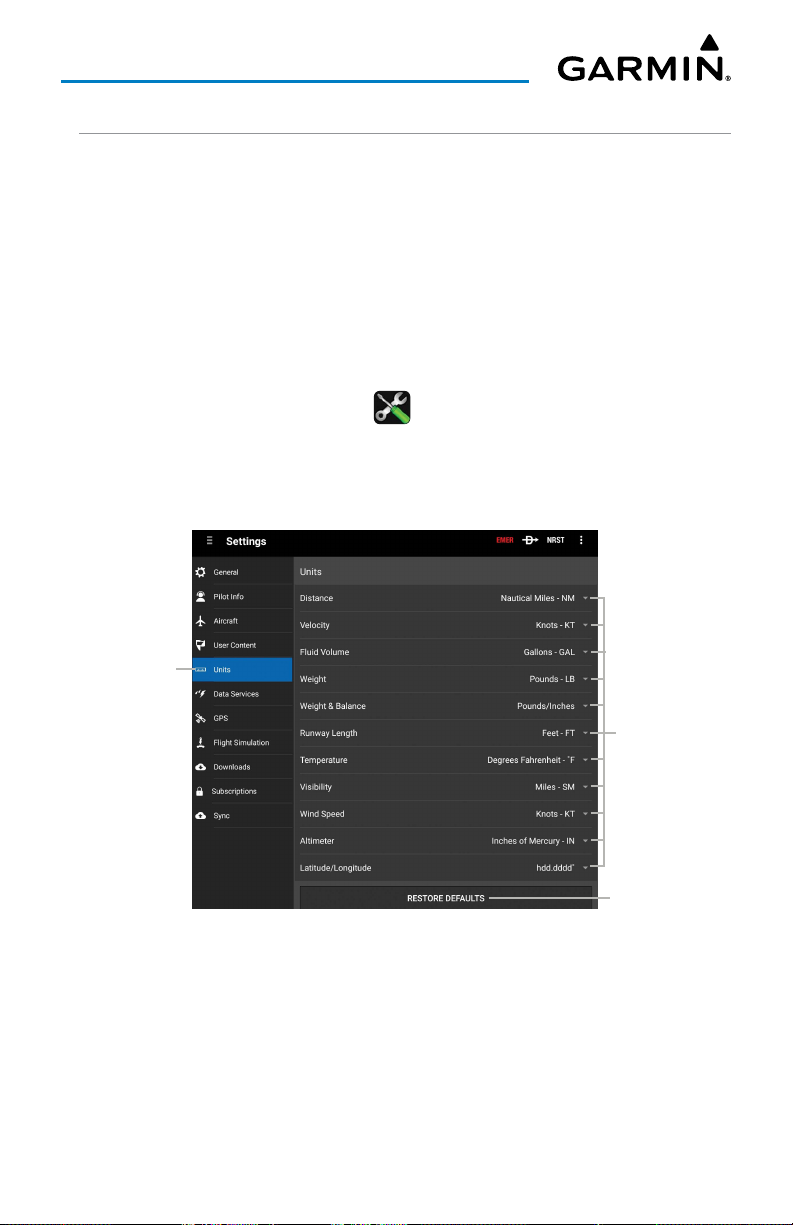
Overview
UNITS
The Units Tab can set the displayed units of measure for the following metrics:
• Distance • Weight & Balance • Wind Speed
• Velocity • Runway Length • Altimeter
• Fluid Volume • Temperature • Latitude/Longitude
• Weight • Visibility
Adjusting Units Settings:
1)
From any page, touch
2)
Touch the
3)
Touch the unit of measurement to display options and adjust as desired.
4)
If necessary, touch
Units
Home
> .
Tab.
Restore Defaults
to revert back to factory settings.
Touch
to View
Touch to Adjust
Settings
Touch to Restore
Default Settings
Settings - Units Tab
Garmin Pilot for Android User’s Guide190-01532-00 Rev. U 42
Page 57
Overview
DATA SERVICES
The Data Services Tab provides information about the current source of weather
data and the age of Garmin Weather Data items cached on the device. The age and
status of weather data for FIS-B-sourced weather is viewable under the corresponding
FIS-B Device tab. Weather data is available from three sources, Garmin Weather Data
Services, FIS-B weather when connected to a compatible FIS-B device via a Connext
link. Garmin Weather Data Services requires a data connection through Wi-Fi or
cellular network. FIS-B weather requires additional hardware.
Adjusting Worldwide NOTAM Coverage Settings:
1)
From any page, touch
2)
Touch the
3)
Touch next to
Data Services
feature will be automatically enabled with the proper subcription updated
and downloaded.
Adjusting Worldwide Winds Aloft Coverage Settings:
1)
From any page, touch
2)
Touch the
Data Services
Home
> .
Tab.
Worldwide NOTAM Coverage
Home
> .
Tab.
to toggle On/Off.
This
3)
Touch next to
Worldwide Winds Aloft Coverage
to toggle On/Off.
The winds aloft forecast data is based on the Global Forecast System (GFS)
weather model and provides detailed coverage for the selected area. This
feature will be automatically enabled with the proper subcription updated
and downloaded.
Adjusting Baron Mobile Link Settings:
1)
From any page, touch
2)
Touch the
3)
Touch next to
Link provides in-cockpit weather using your XM weather receiver and the
Mobile Link Wi-Fi device.
4)
If necessary, touch to view info regarding the current Wi-Fi connection.
Data Services
Home
> .
Tab.
Connection Status
Garmin Pilot for Android User’s Guide190-01532-00 Rev. U 43
to toggle On/Off. Baron Mobile
Page 58
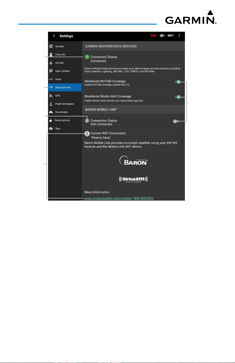
Overview
Connection
Status
Touch
to View
Connection
Status
Touch to
View Info
Touch to
Toggle
On/Off
Settings - Data Services
Garmin Pilot for Android User’s Guide190-01532-00 Rev. U 44
Page 59
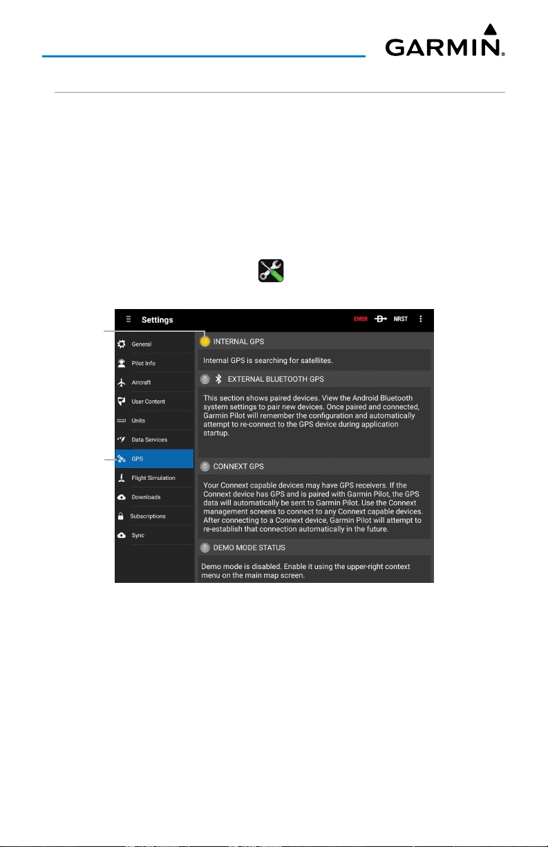
Overview
GPS
Most Android devices are built with an internal GPS receiver. These may work
fine in smaller aircraft but often a stronger, external GPS receiver is necessary. If
an Android device does not include a GPS receiver, then a Garmin GLO™ portable
GPS and GLONASS receiver or a Connext GPS and ADS-B receiver will be required to
take advantage of the navigation features of Garmin Pilot. Third party GPS receiver
applications are no longer recommended for Garmin Pilot to receive location data.
Adjusting GPS Settings:
1)
From any page, touch
2)
Touch the
Current
GPS Mode
& Status
GPS
Home
> .
Tab to view and adjust connected devices.
Touch
to View
Settings - GPS Tab
Garmin Pilot for Android User’s Guide190-01532-00 Rev. U 45
Page 60
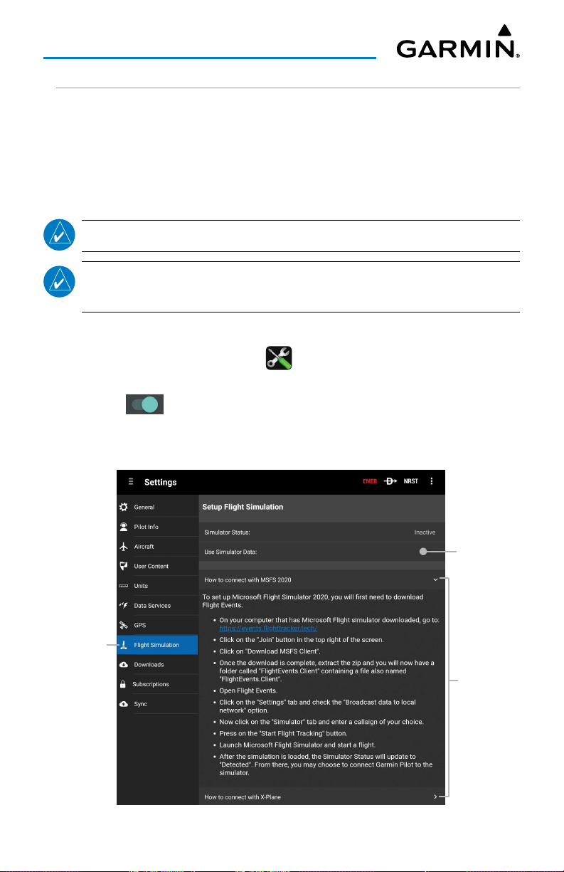
Overview
FLIGHT SIMULATION INTEGRATION
The Flight Simulation Tab provides information about the status of a flight simulator
associated with the current Garmin Pilot account and device. Garmin Pilot can connect
to your X-Plane or Microsoft Flight Simulator 2020 (MSFS 2020) software through a
Wi-Fi connection. To aid in User accessibility, detailed instructions on how to connect
to the desired flight simulator are provided within Garmin Pilot.
NOTE:
NOTE:
Garmin Pilot requires X-Plane version 10.30 or higher.
The Android device running Garmin Pilot, and the computer with the
flight simulator software, should be connected to the same Wi-Fi access point.
Connecting Garmin Pilot to a Flight Simulator:
1)
From any page, touch
2)
Touch the
3)
Touch to toggle the
4)
Touch
Or
: Touch
Touch
to View
Flight Simulation
How to connect with MSFS 2020
How to connect with X-Plane
Home
> .
Tab.
Use Simulator Data
On/Off.
.
.
Touch to
Toggle
On/Off
Touch
to View/
Collapse
Info
Settings - Flight Simulation - Microsoft Flight Simulator 2020
Garmin Pilot for Android User’s Guide190-01532-00 Rev. U 46
Page 61
Overview
DOWNLOADS
The Downloads Tab allows the User to adjust settings for a multiple items. First,
Auto-Download Pilot Updates
cycles as they become available. Second,
Data for large downloads when Wi-Fi is not availble. Lastly,
which provides a visual display of certain downloadable areas (if mapping information
is available). If disabled, this will show all downloads in list form instead.
, which automatically downloads file updates and next
Allow Mobile Data
, which allows Mobile
Enable Download Map
,
NOTE:
More details related to the specifics of the Downloads portion of Garmin
Pilot are presented in greater detail at later stages of this document.
Adjusting Auto-Download Pilot Updates Settings:
1)
From any page, touch
2)
Touch the
3)
Touch next to
NOTE:
the device. Please ensure the device has the proper storage space available.
Downloads
When toggled 'On', this setting may require additional storage space on
Home
> .
Tab.
Auto-Download Pilot Updates
to toggle On/Off.
Adjusting Allow Mobile Data Settings:
1)
From any page, touch
2)
Touch the
3)
Touch next to
Downloads
Home
> .
Tab.
Allow Mobile Data
to toggle On/Off.
Adjusting Enable Download Map Settings:
1)
From any page, touch
2)
Touch the
3)
Touch next to
Downloads
Home
> .
Tab.
Enable Download Map
to toggle On/Off.
Garmin Pilot for Android User’s Guide190-01532-00 Rev. U 47
Page 62
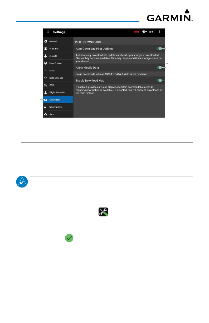
Overview
Touch to
Toggle
On/Off
Touch
to View
Settings - Downloads
SUBSCRIPTIONS
The Subscriptions Tab provides information about the status of any subscription
associated with the current Garmin Pilot account and the ability to purchase annual or
monthly subscriptions or renew expired subscriptions.
NOTE:
With an active subscription, Garmin Pilot can be installed on up to three
device at the same time, typically a mobile phone and a tablet device.
Viewing/Adjusting Account:
1)
From any page, touch
2)
Touch the
3)
If necessary,
Subscriptions
touch the expired subscription to download. When properly
Home
> .
Tab to view current status.
downloaded, a will be displayed along with an Expiration Date.
4)
If necessary, touch the
Pilot subscriptions and the device(s) using these items via fly.garmin.com.
Manage Account
Garmin Pilot for Android User’s Guide190-01532-00 Rev. U 48
button to view current Garmin
Page 63
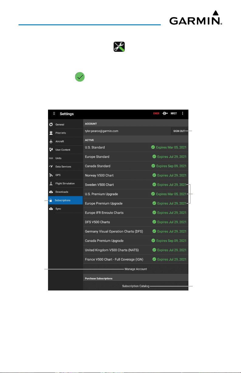
Overview
Viewing/Adjusting Subscription Catalog:
1)
From any page, touch
2)
Touch the
3)
If necessary,
Subscriptions
touch the expired subscription to download. When properly
Home
> .
Tab to view current status.
downloaded, a will be displayed along with an Expiration Date.
4)
If necessary, touch the
items via fly.garmin.com.
Touch
to View
Subscription Catalog
button to purchase necessary
Touch to
Change Account
Subscription
Status &
Expiration Date
Touch to
Manage
Garmin
Account
Touch to View
Subscription
Settings - Subscriptions
Garmin Pilot for Android User’s Guide190-01532-00 Rev. U 49
Catalog
Page 64
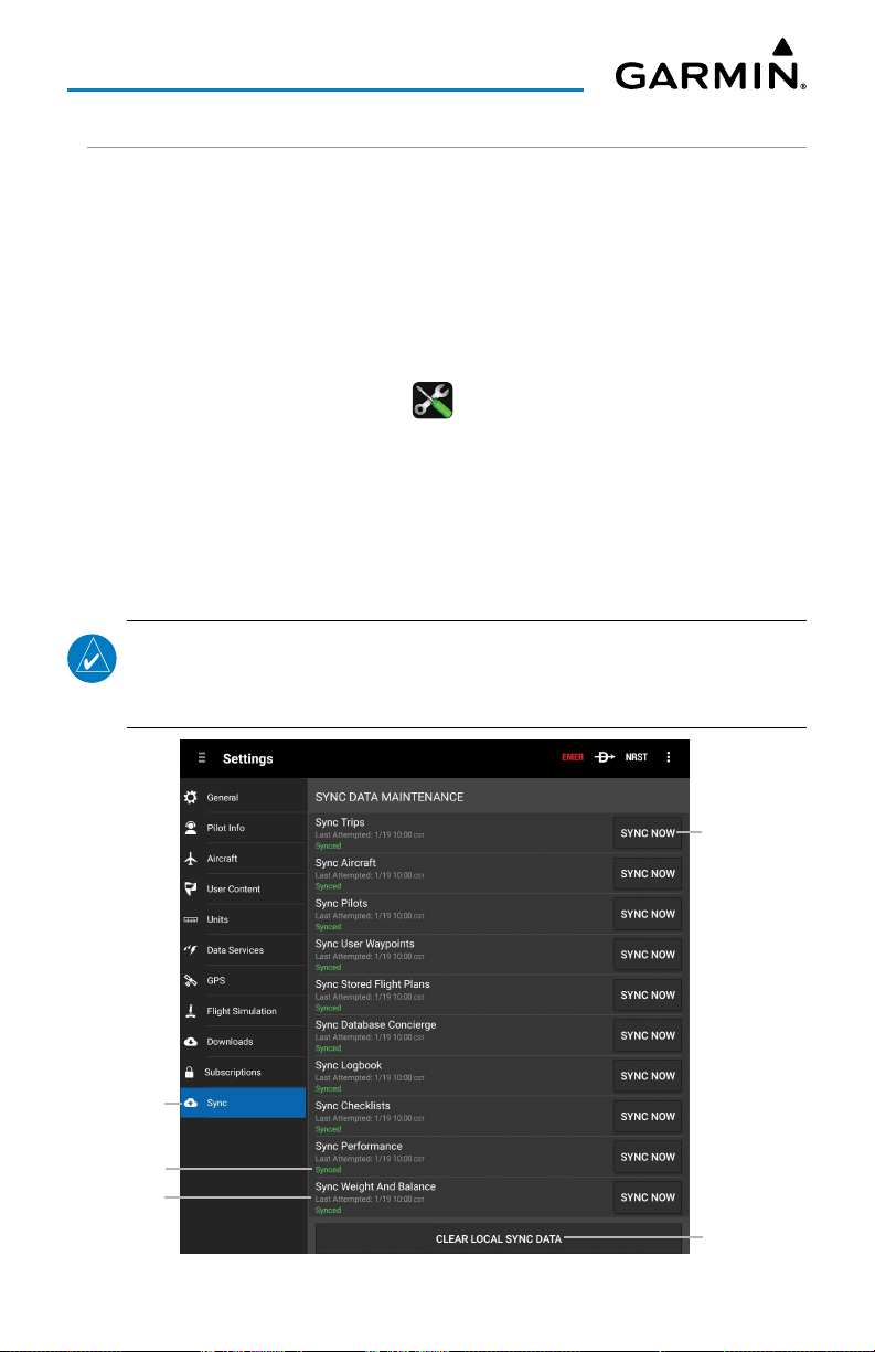
Overview
SYNC
The Sync Tab provides information about the sync status of any data associated
with the current device. The User can view the Last Attempt (Date & Time) and Status
(Synced or Sync Failed) of various pieces of data such as Trips, Aircraft, Pilots, User
Waypoints, Stored Flight Plans, Database Concierge, Logbook, Checklists, Performance,
and Weight and Balance.
Viewing/Adjusting Sync Status:
1)
From any page, touch
2)
Touch the
3)
Touch the
successful, "Synced" will be displayed in green text along with the Date
(MM:DD) and Time (HH:MM). If unsuccessful, "Not Synced" will be
displayed in red text along with the Date (MM:DD) and Time (HH:MM).
4)
If necessary, touch the
Sync
SYNC NOW
Home
> .
Tab.
button next to the desired data category. If
Clear Local Sync Data
button.
NOTE:
Touching the Clear Local Sync Data button will clear all local sync data
and pull down data stored on the cloud. Only perform this action if there are
issues with the sync data.
Touch to
Sync Data
Touch
to View
Sync Status
Last Sync
Touch to
Clear Data
Settings - Sync
Garmin Pilot for Android User’s Guide190-01532-00 Rev. U 50
Page 65
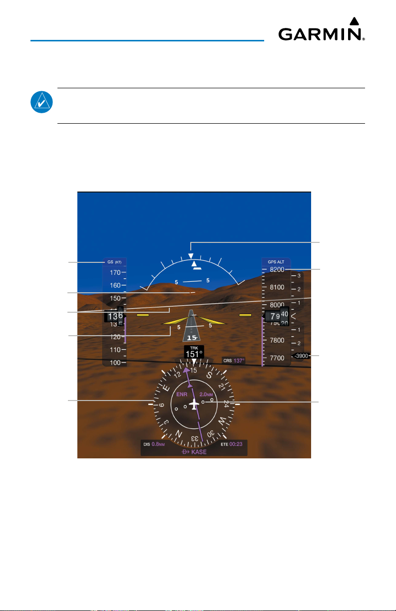
Overview
SYNTHETIC VISION (PREMIUM SUBSCRIPTION)
NOTE:
Synthetic Vision requires either a Flight Stream 510/210, GDL 52/52R,
GDL 39 3D, GTX 345, GTX 45R, G3X Touch, and a Premium subscription.
Synthetic Vision depicts a forward-looking attitude display of the topography
immediately in front of the aircraft. The depicted imagery is derived from the aircraft
attitude, heading, GPS three-dimensional position, and databases of terrain, obstacles,
and other relevant features.
GPS-
derived
Ground
Speed
Pitch Scale
Zero Pitch
Line
Aircraft
Symbol
Roll
Pointer
Geometric
Altitude
(MSL)
GPSderived
Vertical
Speed
HSI
CDI Scale
Synthetic Vision (with GDL 39 3D)
Garmin Pilot for Android User’s Guide190-01532-00 Rev. U 51
Page 66
Overview
The Synthetic Vision terrain display shows land contours (colors are consistent
with those of the topographical map display), large water features, towers, and other
obstacles over 200’ AGL that are included in the obstacle database. Cultural features
on the ground such as roads, highways, railroad tracks, cities, and state boundaries are
not displayed.
Terrain is integrated within Synthetic Vision to provide visual alerts to indicate the
presence of terrain and obstacle threats relevant to the projected flight path. Terrain
alerts are displayed in red and yellow shading.
The terrain display is intended for situational awareness only. It may not provide the
accuracy or fidelity on which to base decisions and plan maneuvers to avoid terrain
or obstacles. Navigation must not be predicated solely upon the use of the terrain or
obstacle data displayed by Synthetic Vision.
NOTE:
when compatible devices are not configured.
'No Attitude Information' is displayed in place of the Attitude Indicator
SYNTHETIC VISION OPERATION
Synthetic Vision is activated by touching
Activating night mode:
1)
From any page, touch
2)
Touch
Menu
>
Home
Night Mode
ZERO PITCH LINE
The Zero Pitch Line is drawn completely across the display and represents the
aircraft attitude with respect to the horizon. It may not align with the terrain horizon,
particularly when the terrain is mountainous or when the aircraft is flown at high
altitudes.
Home
> .
.
> .
Garmin Pilot for Android User’s Guide190-01532-00 Rev. U 52
Page 67
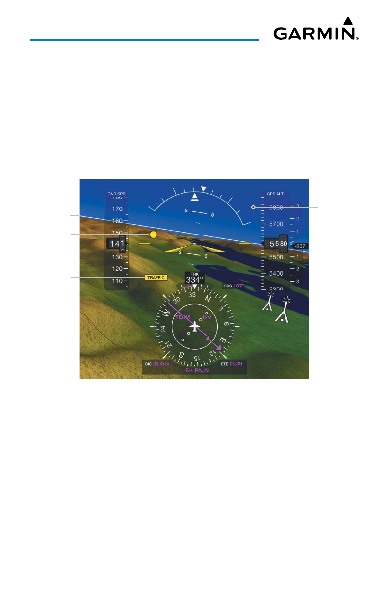
Overview
TRAFFIC (OPTIONAL)
When paired with a Flight Stream 510, Flight Stream 210, GDL 52/52R, GDL 39/GDL
39 3D, GTX 345, or GTX 45R Synthetic Vision displays ADS-B traffic information. Traffic
symbols are displayed in their approximate locations. Traffic symbols are displayed in
three dimensions, appearing larger as they are getting closer, and smaller when they
are further away. Traffic within 250 feet laterally of the aircraft will not be displayed.
Traffic symbols and coloring are consistent with that used for traffic displayed on the
Map Page. If the traffic altitude is unknown, the traffic will not be displayed.
Zero
Pitch Line
Traffic
Traffic Alert
Traffic
Synthetic Vision - Traffic
Garmin Pilot for Android User’s Guide190-01532-00 Rev. U 53
Page 68
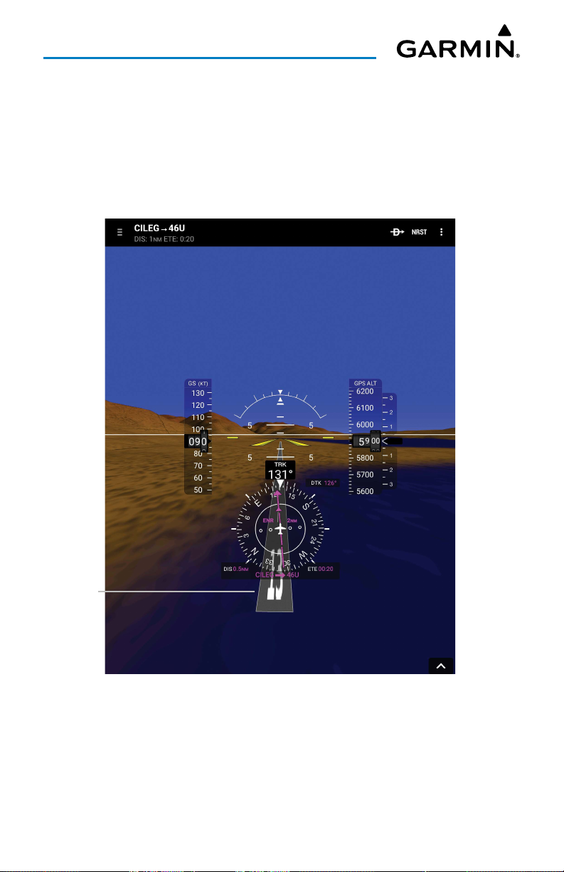
Overview
RUNWAYS
Runway data provides improved awareness of runway location with respect to the
surrounding terrain. All runway thresholds are depicted at their respective elevations
as defined in the database. In some situations, where threshold elevations differ
significantly, crossing runways may appear to be layered. As the aircraft gets closer to
the runway, more detail such as runway numbers and centerlines are displayed.
Runway
Synthetic Vision - Runway
Garmin Pilot for Android User’s Guide190-01532-00 Rev. U 54
Page 69
Overview
SYNTHETIC VISION TERRAIN AND OBSTACLE DATA
Terrain alerting on the synthetic vision display corresponds to the red and yellow X
symbols on the Map Page.
In some instances, a terrain or obstacle alert may be issued with no conflict shading
displayed on the synthetic vision. In these cases, the conflict is outside the Synthetic
Vision field of view.
Obstacles are represented on the synthetic vision display by standard twodimensional tower symbols found on the Inset Map and Navigation Map. Unlike the
Map Page, obstacles on the synthetic vision display do not change colors to warn of
potential conflict with the aircraft’s flight path until the obstacle is associated with an
actual terrain alert. Obstacles greater than 1000 feet below the aircraft altitude are
not shown.
Synthetic Vision - Terrain
Garmin Pilot for Android User’s Guide190-01532-00 Rev. U 55
Page 70
Overview
It is preferred to download the medium or high resolution terrain data when using
Synthetic Vision. The 3D view may not draw correctly with low resolution terrain data.
Synthetic Vision - High Resolution
Terrain Data
Garmin Pilot for Android User’s Guide190-01532-00 Rev. U 56
Synthetic Vision - Low Resolution
Terrain Data
Page 71
Overview
LOGBOOK
The Garmin Pilot Logbook feature allows the pilot to record pertinent flight
information to include the following:
• Generate automatic logbook entries using GPS data collected during the flight.
• Add manual entries or modify auto-entries.
• Notification of auto-generated entries via red badges on Logbook icon.
• Smart Suggestions auto-populates previously used instructor and aircraft
information.
• Track currency information including day and night take-offs, night duration, and
cross country.
• Enter signed endorsements and generate reports.
• Optional automatic synchronization with the flyGarmin website.
• Adding photographs to logbook entries.
The Garmin Pilot logbook requires at least one aircraft entered in
>
Aircraft
in order to create valid entries. If a logbook entry is created without any
aircraft types, the Aircraft Type field will prompt to add an aircraft type.
FLIGHT LOG ENTRIES
Manually Adding Logbook Entry:
1)
From any page, touch
2)
If necessary, touch
3)
Touch
Add Entry
4)
Touch the desired Flight Log entry field(s) to add flight data.
5)
Under the Duration section, use the buttons to copy the value from the
Total field to another field.
6)
If the flight included multiple approaches, touch
7)
If the flight was dual given, the instructor enters the following fields:
Instructor Name, Certificate Number
a)
b)
Touch
Touch
Add Signature
Save
Home
> .
Entries
at the top of the page.
. Garmin Pilot will create a new entry.
Add Approach
, and
Certificate Expiration
to sign the entry.
.
Garmin Pilot for Android User’s Guide190-01532-00 Rev. U 57
Home
>
for each.
.
Page 72
Overview
Entries Tab
Add New
Entry
Touch
to View
Flight Log
Entries
Lock Entry
Touch to
Adjust
Touch to
Share
Touch
to View
on Map
Touch to
Add Photo
Touch to
Modify
Logbook Entries
Enabling Automatic Flight Log Entries:
NOTE:
The terrain download is recommended for optimum performance of
Automatic Flight Logging.
1)
From any page, touch
2)
Scroll down to the
3)
Touch next to
4)
If desired, enter a value for any of the following
Setup
fields.
Home
> >
Automatic Flight Log Setup
Enable Auto Flight Logging
Garmin Pilot for Android User’s Guide190-01532-00 Rev. U 58
Settings
fields.
.
.
Automatic Flight Log
Page 73
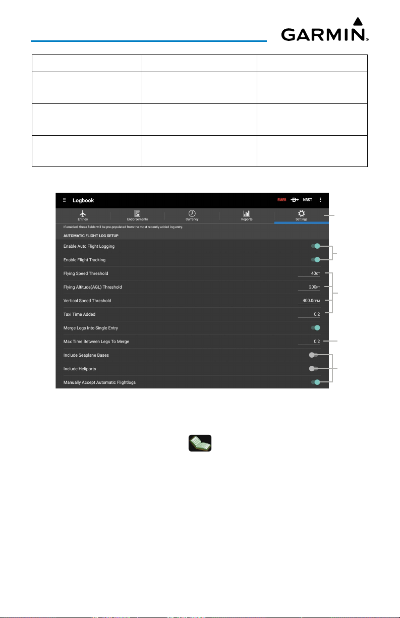
Overview
• Enable Flight Tracking • Taxi Time Added • Include Heliports
• Flying Speed Threshold • Merge Legs Into Single
Entry
• Flying Altitude (AGL)
Threshold
• Vertical Speed
• Max Time Between
Legs To Merge
• Include Seaplane Bases
• Manually Accept
Automatic Logs
Threshold
Automatic Flight Log Setup Fields
Settings Tab
Touch to
Enable
Touch to
Enter Data
Automatic Flight Log Setup
Accepting Automatic Flight Log Entries:
1)
From any page, touch
2)
Touch
Auto-Gen Flights
Optionally, touch Accept All to add all automatic entries to the Logbook.
3)
Touch a flight log entry.
4)
Touch
Accept
to add the entry to the logbook.
Home
> >
.
Garmin Pilot for Android User’s Guide190-01532-00 Rev. U 59
Entries
.
Touch to
Enter Data
Touch to
Toggle
On/Off
Page 74
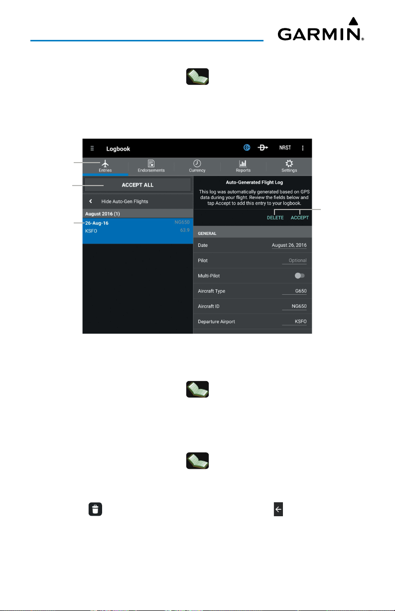
Overview
Deleting Automatic Flight Log Entries:
1)
From any page, touch
2)
Touch
Auto-Gen Flights
3)
Touch a flight log entry.
4)
Touch
Delete
Entries View
Touch to
Accept ALL
Auto Entries
New Auto
Entry
.
Home
.
>
> Entries
.
Touch to
Accept or
Delete Auto
Entry
Flight Log Entry - Automatic
Modifying Flight Log Entry:
1)
From any page, touch
2)
Touch the desired entry to modify.
3)
Modify the desired Flight Log entry fields.
Home
> >
Entries
.
Deleting Flight Log Entry:
1)
From any page, touch
2)
Touch and hold the desired entry to delete.
3)
If desired, touch additional entries to delete.
4)
Touch at the top of the screen to delete or touch to cancel.
Home
> >
Garmin Pilot for Android User’s Guide190-01532-00 Rev. U 60
Entries
.
Page 75
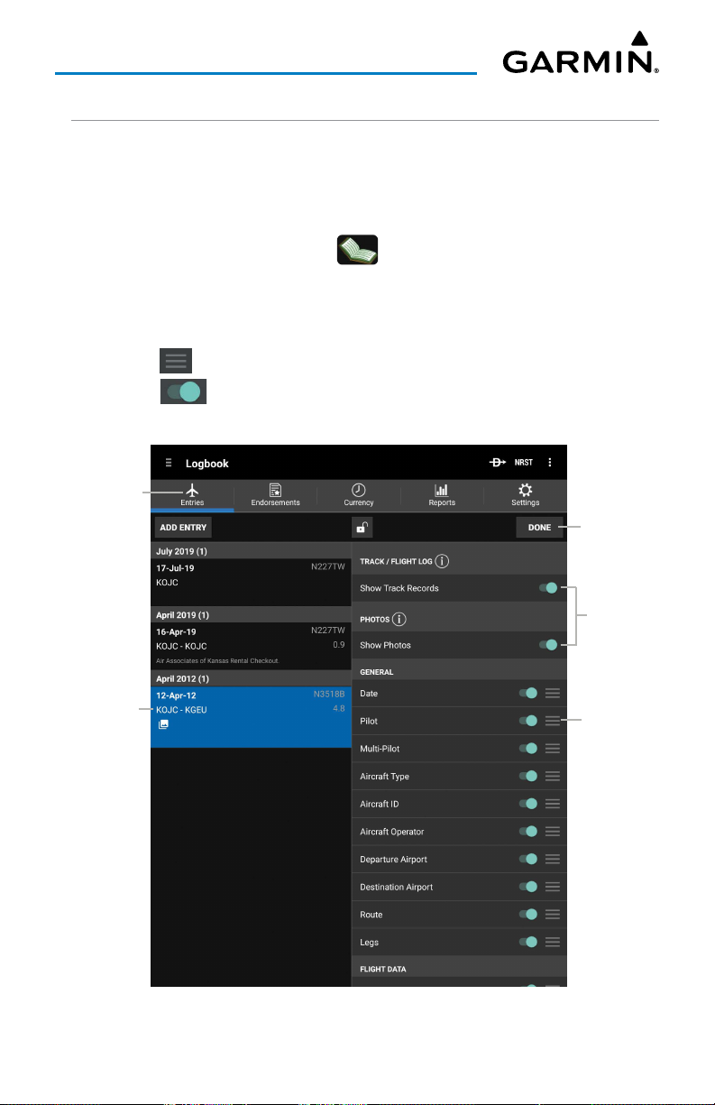
Overview
FLIGHT LOG FIELDS
The order of the Flight Log Fields can be arranged, and each flight log field can be
configured ON or Off.
Configuring logbook fields:
1)
From any page, touch
2)
Touch the desired entry to configure or touch
entry.
3)
Touch
Configure Fields
4)
Touch and drag to arrange the fields in the desired order.
5)
Touch next to desired fields to hide or display them.
6)
Touch
Done
.
Home
.
> >
Entries
Add Entry
.
to create a new
Entries Tab
Selected
Logbook Entry
Touch to
Save &
Close
Touch to
Toggle 'ON/
OFF'
Touch &
Drag to
Arrange
Fields
Flight Log Field Configuration
Garmin Pilot for Android User’s Guide190-01532-00 Rev. U 61
Page 76
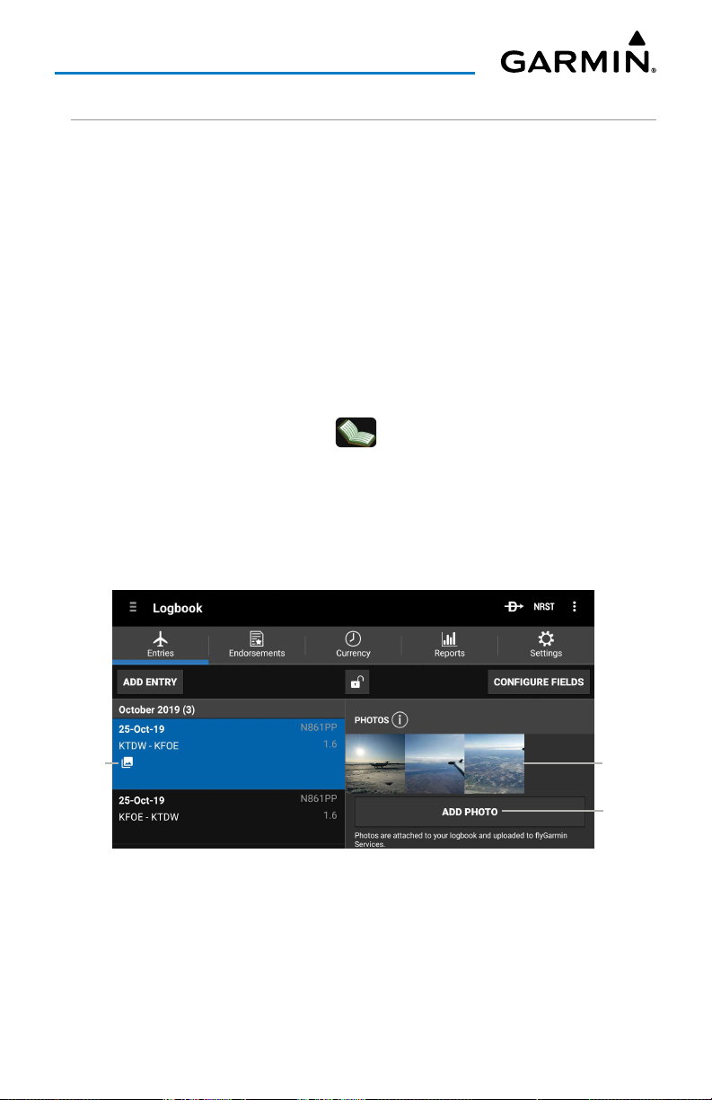
Overview
LOGBOOK PHOTOS
The Logbook Photos feature allows the pilot to attach unlimited photos to logbook
flight entries.
• Logbook photos may be taken while in flight using a device's camera, and are
automatically added to the provisional logbook entry.
• Logbook photos can be attached to existing logbook entries from the device's
photo library or flyGarmin.
• Logbook photos are securely stored within flyGarmin and can be synced across all
devices.
Adding photos to a logbook entry:
1)
From any page, touch
2)
Touch
Add Entry
icon.
3)
Take a photo from the device, add one from the device's photo library, or
add a photo from the Virb photo library.
Home
> .
or an existing logbook entry and select the
Add Photo
Photos
Attached
Touch to
Enlarge
Photo
Touch to
Add Photo
Logbook Photos
Garmin Pilot for Android User’s Guide190-01532-00 Rev. U 62
Page 77
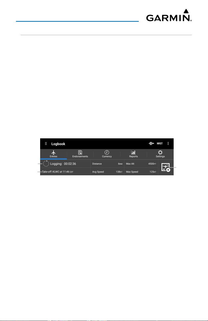
Overview
LOGBOOK AUTO-LOGGING
The Logbook Auto-Logging view on the logbook entries tab captures and displays
real-time flight data including:
• Duration of flight
• Time of departure
• Distance flown
• Average speed
• Maximum altitude
• Maximum speed
Logbook Auto-Logging also supports taking photos while in flight or attaching
images from the device's library to the logbook entry.
Actively
Logging Flight
Departure Info
Touch to
Add Photo
Logbook Auto-Logging
Garmin Pilot for Android User’s Guide190-01532-00 Rev. U 63
Page 78
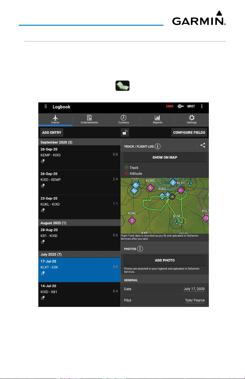
Overview
LOGBOOK TRACKS
Garmin Pilot automatically creates a track of a flight and attaches the file to the
entry in the logbook.
Viewing logbook tracks:
1)
From any page, touch
2)
Touch
Show on Map
Home
> .
on a selected logbook entry.
Logbook Tracks
Garmin Pilot for Android User’s Guide190-01532-00 Rev. U 64
Page 79
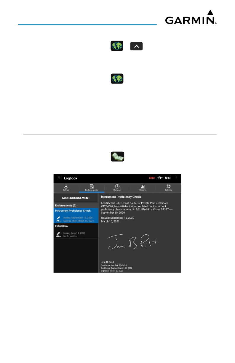
Overview
Adding logbook widget from split screen mode:
1)
From any page, touch
2)
Touch
Add Widget
Home
> > >
and select
Logbook Tracks
Hiding logbook tracks from the map:
1)
From any page, touch
2)
Long press on the desired area in the Map Pane until the Radial Menu
appears.
3)
Select the
4)
Touch on the
Track
Hide
Home
> .
icon from the radial menu.
button to remove the track on the map.
ENDORSEMENTS
Viewing Endorsements:
1)
From any page, touch
2)
Touch the desired endorsement.
Home
> >
Endorsements
Widgets
.
.
.
Endorsement View
Garmin Pilot for Android User’s Guide190-01532-00 Rev. U 65
Page 80
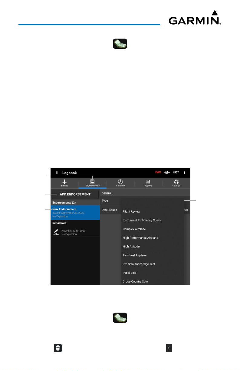
Overview
Adding Endorsements:
1)
From any page, touch
2)
Touch
Add Endorsement
3)
Touch
Type
.
4)
Touch the desired Type from the list.
5)
The pilot enters the following Endorsement Fields:
Name; Gender; Pilot Certificate; Certificate Number; Make and Model
6)
Touch
Title
.
7)
Enter a title for the endorsement and touch
8)
If desired, enter the
9)
The instructor enters the following Instructor fields:
Certificate Number
a)
b)
Touch
Touch
Add Signature
Save
Home
FAA Category
, and
.
> >
Endorsements
.
Done
, date
Issued
Certificate Expiration
to sign the entry.
.
First Name, MI, Last
.
, and date
Expires
Instructor Name
.
.
.
,
Endorsements
Touch to Add
Endorsements
Endorsement
Tab
New
Deleting an Endorsement:
1)
From any page, touch
2)
Touch and hold the desired endorsement to delete.
3)
If desired, touch additional endorsements to delete.
4)
Touch at the top of the screen to delete or touch to cancel.
Garmin Pilot for Android User’s Guide190-01532-00 Rev. U 66
Endorsements
Home
> >
Entries
Touch
to Select
Endorsement
Type
.
Page 81
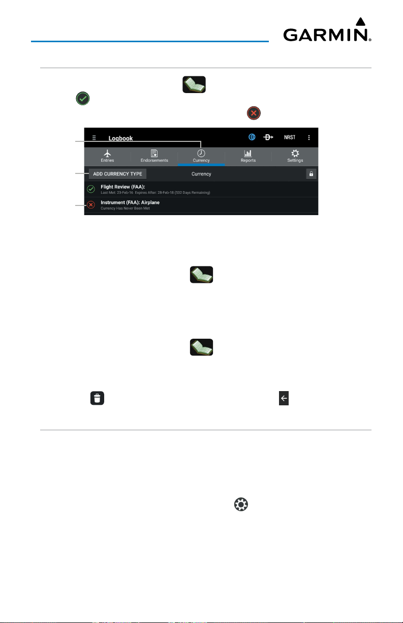
Overview
CURRENCY
To View Currencies, touch
Home
> >
Currency
. When the currency type has
been met, is displayed as well as the date last met, expiration date, and days
remaining. When the currency type has not been met is displayed.
Currency
Tab
Touch to Add
Currency
Type
Currency
List
Logbook - Currency
Adding a currency type:
1)
From any page, touch
2)
Touch
Add Currency Type
3)
Touch the desired Currency Type from the list.
Home
.
> >
Currency
.
Deleting a currency type:
1)
From any page, touch
2)
Touch and hold the desired currency to delete.
3)
If desired, touch additional currencies to delete.
Home
> >
Currency
.
4)
Touch at the top of the screen to delete or touch to cancel.
REPORTS
The Reports tab shows categorized summaries of logbook entries. These summaries
are broadly divided into Visited Airports, Entry Fields, Aircraft Types and Characteristics.
All four categories can further be organized by time frame, using the lookback options
on the left side of the screen. The Reports tab also supports a selectable custom date
range. To change the custom date range, touch to display the Custom Dates
window.
Garmin Pilot for Android User’s Guide190-01532-00 Rev. U 67
Page 82
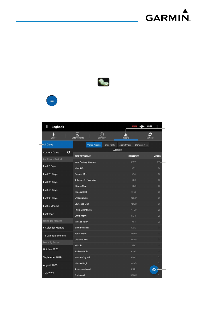
Overview
The Visited Airports category shows the total number of visits to specific airports
from a recorded flight log data. Visited Airports data can be viewed as a List or on
the Map. List View displays data in descending order, with the most frequently visited
airport at the top, along with the airport I.D., and the total number of visits. Touch the
desired Airport Name to view flight details, such as Date, Departure, and Duration.
Viewing Visited Airports - List View:
1)
From any page, touch
2)
Select the desired Date Range on the lefthand side of the screen.
3)
Touch in the bottom, right corner of the screen to display the List
Home
>
> Reports > Visited Airports.
View.
4)
Touch the desired Airport Name to view details.
Reports Tab
Selected
Date Range
Touch to
Filter by
Time Frame
Touch to
View Info
Touch to
View Info
Touch to
View on Map
Logbook - Reports - Visited Airports - List View
Garmin Pilot for Android User’s Guide190-01532-00 Rev. U 68
Page 83
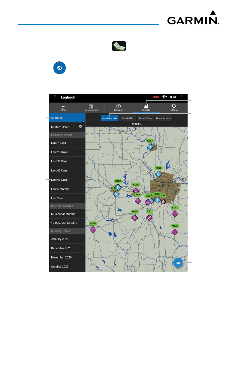
Overview
Viewing Visited Airports - Map View:
1)
From any page, touch
2)
Select the desired Date Range on the lefthand side of the screen.
3)
Touch in the bottom, right corner of the screen to display the Map
Home
>
View.
4)
Touch the desired Airport I.D. to view details.
> Reports > Visited Airports.
Reports Tab
Selected
Date Range
Touch to
Filter by
Time Frame
Touch to
View Info
Touch to
View Info
Touch to
View List
Logbook - Reports - Visited Airports - Map View
Garmin Pilot for Android User’s Guide190-01532-00 Rev. U 69
Page 84
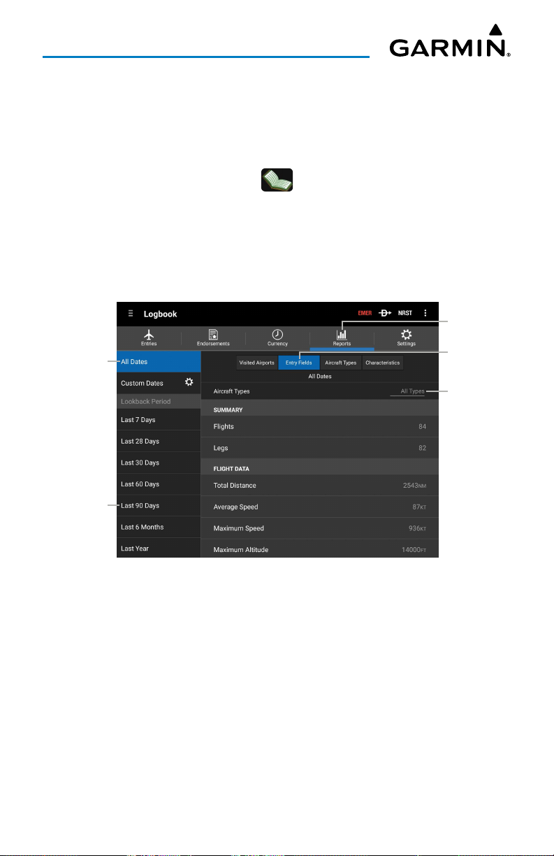
Overview
The Entry Fields category shows totals of numeric flight log data. This category also
includes an Aircraft Types field for narrowing flight log data to aircraft types specified in
Logbook Settings. This Aircraft Types field is different than the Aircraft Types category.
Viewing Entry Fields:
1)
From any page, touch
2)
Select the desired Date Range on the lefthand side of the screen.
3)
Touch the
All Types
Home
>
> Reports > Entry Fields.
field in the upper right corner and adjust to filter data
as desired.
4)
Scroll down to view logbook entries categorized by Summary, Flight Data,
Flight Time, General Operations, and IFR Operations.
Reports Tab
Selected
Date Range
Touch to
Filter by
Time Frame
Touch to
View Info
Touch to
Filter by
Aircraft Type
Logbook - Reports - Entry Fields
Garmin Pilot for Android User’s Guide190-01532-00 Rev. U 70
Page 85
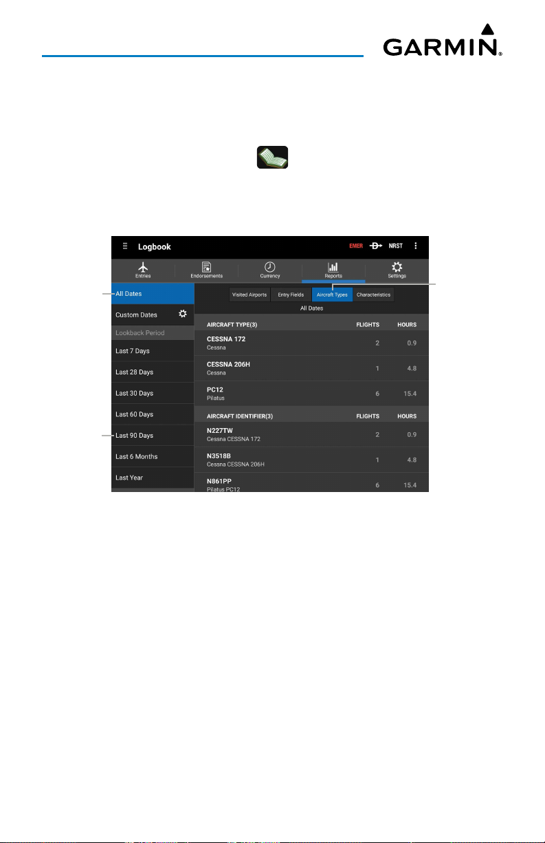
Overview
The Aircraft Types category displays total data specific to aircraft types instead of
flights.
Viewing Aircraft Types:
1)
From any page, touch
2)
Select the desired Date Range on the lefthand side of the screen.
3)
Scroll down to view logbook entries categorized by Aircrafty Type(s) and
Home
>
> Reports > Aircraft Types.
Aircraft Identifier(s).
Touch to
Selected
Date Range
Touch to
Filter by
Time Frame
Display Flights/
Hours by
Aircraft Type
Logbook - Reports - Aircraft Types
Garmin Pilot for Android User’s Guide190-01532-00 Rev. U 71
Page 86
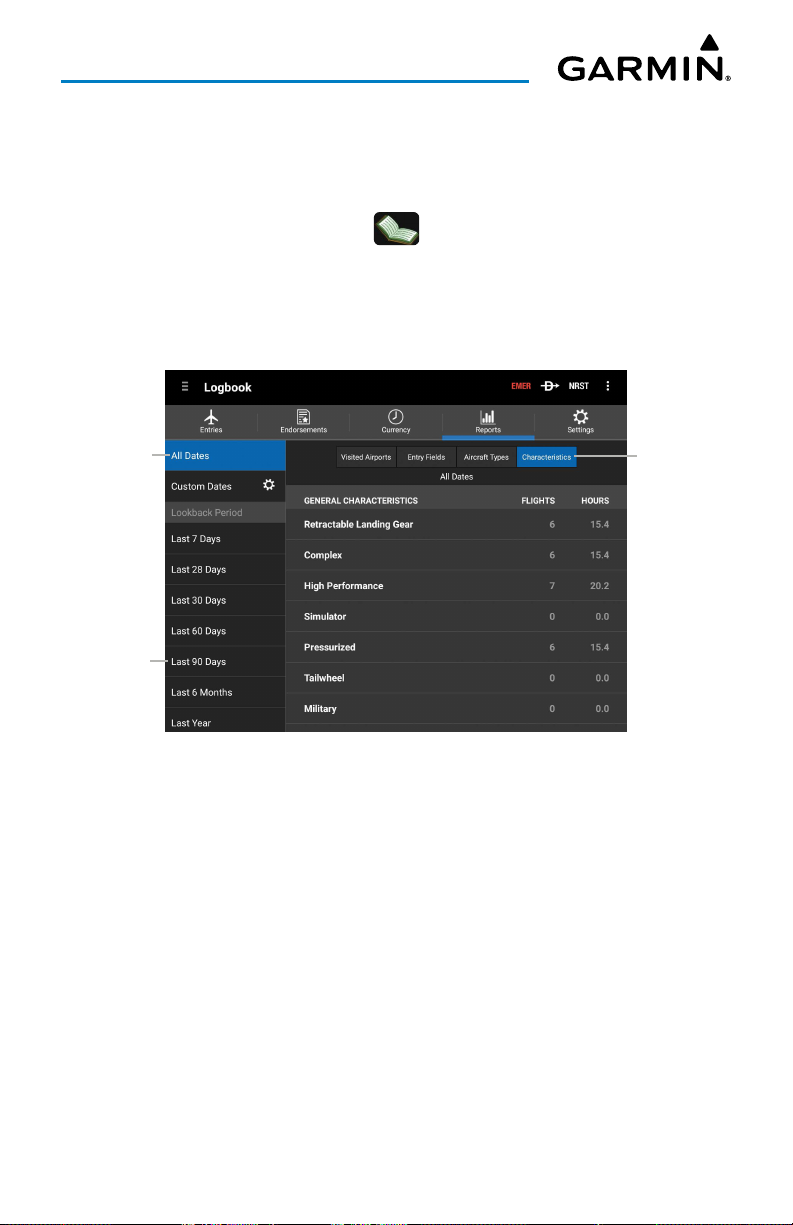
Overview
The Characteristics category displays flight log data pertaining to aircraft
characteristics, regardless of aircraft type or flights.
Viewing Characteristics:
1)
From any page, touch
2)
Select the desired Date Range on the lefthand side of the screen.
3)
Scroll down to view logbook entries categorized by General Characteristics
Home
>
> Reports > Characteristics.
(Retractable Landing Gear, Complex, High Performance, etc.), Engine Type,
Arcraft Category, Aircraft Class, and Aircraft Manufacturer.
Touch to
Selected
Date Range
Touch to
Filter by
Time Frame
Display
Flights/Hours
by Aircraft
Characteristics
Logbook - Reports - Characteristics
Garmin Pilot for Android User’s Guide190-01532-00 Rev. U 72
Page 87
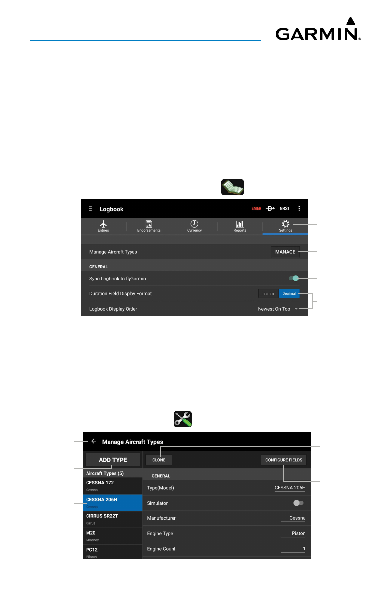
Overview
LOGBOOK SETTINGS
GENERAL SETTINGS
The Settings tab provides options to fine tune Logbook functions.
to flyGarmin
will enable or disable storing logbook entries to Garmin's web service.
By default, the Logbook shows time values in decimal hours. Touch
Display Format
to change time values to hours + minutes.
Logbook Display Order
Sync Logbook
Duration Field
can be used to reverse the order of logbook entries in the other logbook tabs.
Logbook Settings can be accessed by touching
Logbook Settings - General
> Settings.
Settings Tab
Touch to
Manage
Aircraft Types
Touch to Sync
Touch to
Adjust
MANAGING AIRCRAFT TYPES
Touch
Manage
Aircraft type information here is used in the Entries tab, providing options in the Type
fields for new flight log entries. This aircraft information is also separate from the
aircraft information found in
to add, delete and edit aircraft information used in Logbook entries.
Home
> >
Aircraft
, which is used for flight planning.
Return to
Settings Tab
Add Aircraft
Type
View Aircraft
Type
Clone
Current
Aircraft Type
Configure
Aircraft
Type Fields
Logbook Settings - Viewing Aircraft Type
Garmin Pilot for Android User’s Guide190-01532-00 Rev. U 73
Page 88
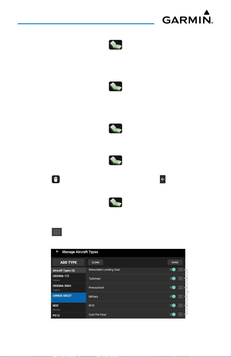
Overview
Adding Aircraft Type:
1)
From any page, touch
2)
Touch
Add Aircraft Type
3)
Touch the desired Aircraft Type entry field(s) to add an entry.
Modifying Aircraft Type:
1)
From any page, touch
2)
Touch the desired Aircraft Type to modify.
3)
Touch the desired Aircraft Type entry field(s) to modify.
Copying Aircraft Type:
1)
From any page, touch
2)
Touch the desired aircraft type to copy >
Deleting Aircraft Type:
1)
From any page, touch
2)
Touch and hold the desired aircraft type to delete.
3)
Touch at the top of the screen to delete or touch to cancel.
Home
> >
Settings
>
Manage
.
. Garmin Pilot will create a new aircraft type entry.
Home
Home
Home
> >
> >
> >
Settings
Settings
Clone
.
Settings
>
Manage
>
Manage
>
Manage
.
.
.
Configuring Aircraft Type Fields:
1)
From any page, touch
2)
Touch any aircraft type
3)
Touch
Configure Fields.
4)
Touch and drag to arrange the fields in the desired order.
5)
Touch and drag the switch ON/OFF to display the desired fields >
Logbook Settings - Configure Aircraft Type Fields
Home
> >
Garmin Pilot for Android User’s Guide190-01532-00 Rev. U 74
Settings
>
Manage
.
Done.
Touch &
Arrange
Type Fields
Page 89
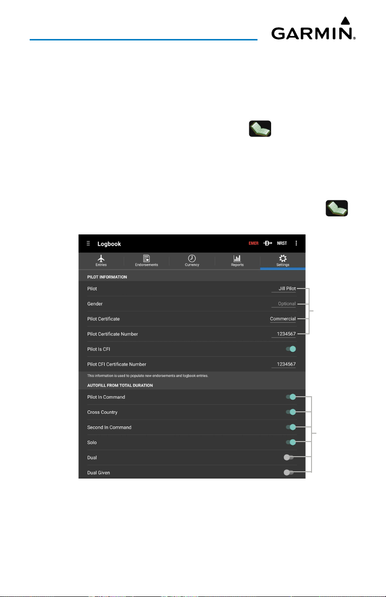
Overview
PILOT INFORMATION
When a new flight log entry or endorsement is created, the Pilot, Gender, Pilot
Certificate and Pilot Certificate Number fields will automatically populate with
information specified here. This applies to both manual and automatic flight log entries.
Pilot Information Settings can be accessed by touching
> Settings.
AUTOFILL FROM TOTAL DURATION
These options will automatically copy the Total Duration value when a new flight log
entry is created. This applies to both manual and automatic flight log entries.
Logbook Autofill From Total Duration Settings can be accessed by touching
Settings.
Scroll down to adjust as necessary.
Touch to
Enter Data
>
Touch to
Toggle
On/Off
Logbook Settings - Pilot Info & Autofill
Garmin Pilot for Android User’s Guide190-01532-00 Rev. U 75
Page 90
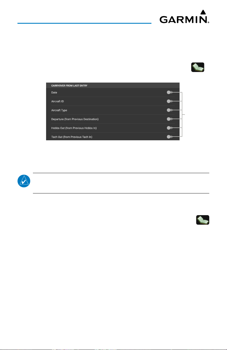
Overview
CARRYOVER FROM LAST ENTRY
When a new flight log entry is created, Garmin Pilot looks at the previous flight log
and fills in these fields based on the previous entry.
Logbook Carryover From Last Entry Settings can be accessed by touching
Settings.
Scroll down to adjust as necessary.
Touch to
Toggle
On/Off
Logbook Settings - Carryover From Last Entry
AUTOMATIC FLIGHT LOG SETUP
NOTE:
Automatic Flight Logging.
When
automatically create a flight log entry.
Logbook Automatic Flight Log Setup Settings can be accessed by touching
> Settings.
configure the behavior of the flight log function.
The terrain download is recommended for optimum performance of
Automatic Flight Log
is enabled, Garmin Pilot detects takeoff and landing to
Scroll down to adjust as necessary. The settings below allow the pilot to
>
Garmin Pilot for Android User’s Guide190-01532-00 Rev. U 76
Page 91
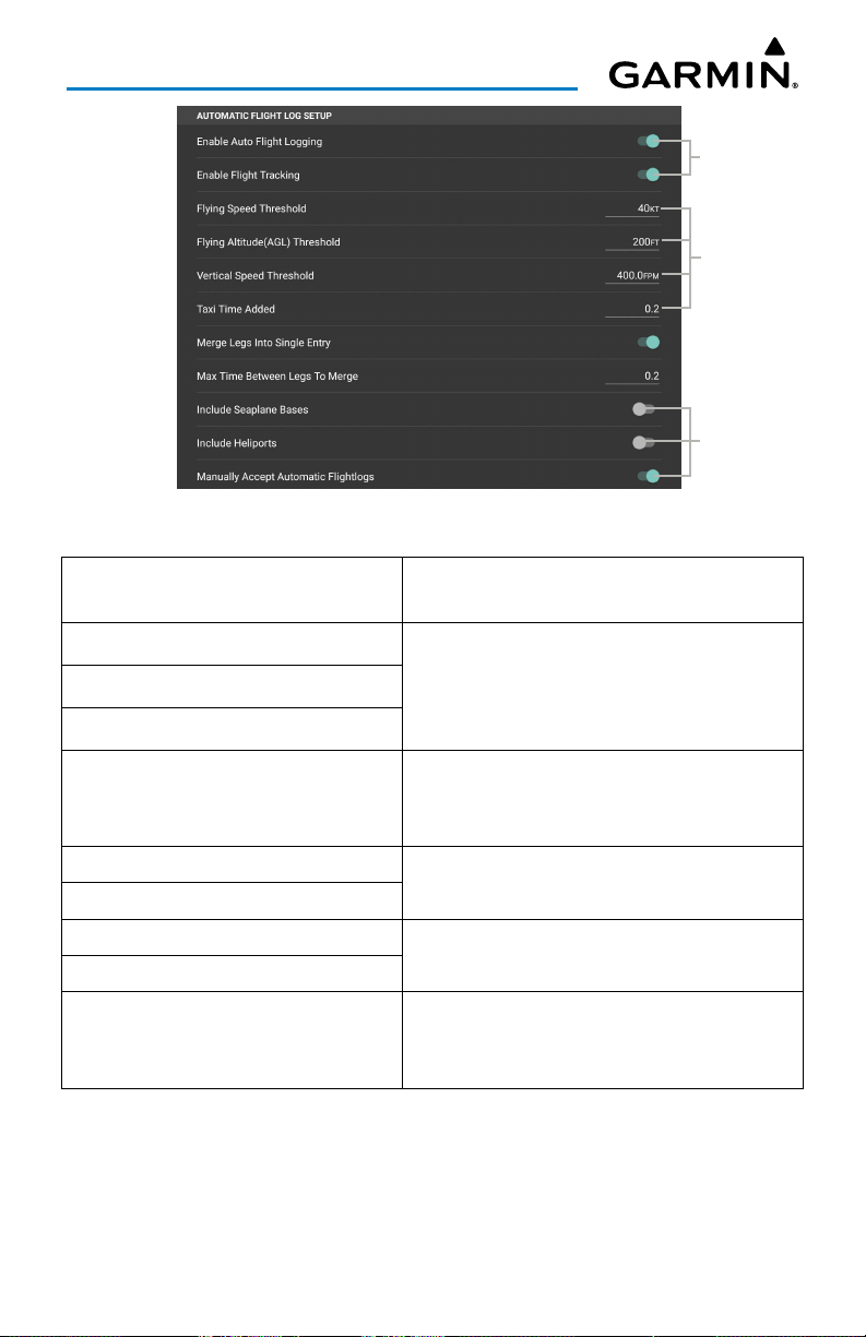
Overview
Touch to
Toggle
On/Off
Touch to
Enter Data
Touch to
Toggle
On/Off
Logbook Settings - Automatic Flight Log Setup
Enable Auto Flight Logging
Flying Speed Threshold
Flying Altitude (AGL) Threshold
Vertical Speed Threshold
Taxi Time Added
Merge Legs Into Single Entry
Max Time Between Legs To Merge
Include Seaplane Bases
Include Heliports
Manually Accept Automatic
Flightlogs
Automatic Flight Log Setup Fields
Allows Garmin Pilot to automatically create
flight logs.
Used to optimize the detection of takeoff
when terrain is not available. If terrain has
been downloaded then it is used to determine
when the aircraft is flying.
Automatically added to the total duration to
account for taxi time on the ground. Defaults
to zero.
These parameters control if two flights will be
automatically merged into one logbook entry.
Enable these options if operating out of a
seaplane base or heliport.
When enabled, the user must manually review
and accept all auto-generated flight log
entries.
Garmin Pilot for Android User’s Guide190-01532-00 Rev. U 77
Page 92
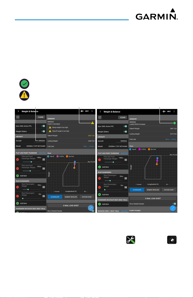
Overview
WEIGHT AND BALANCE
Weight and balance is calculated within Garmin Pilot to determine if the airplane
is properly loaded within CG limits. Garmin Pilot syncs the current flight plan to
incorporate initial fuel and winds aloft data into the weight and balance calculations.
Aircraft performance data may be imported from Garmin's aircraft library or manually
entered from the aircraft's Pilot Operating Handbook (POH), into Garmin Pilot.
is displayed when the aircraft is loaded within the CG envelope.
is displayed when the aircraft is loaded out of the CG envelope.
Touch to Select Aircraft
Out of CG Envelope
Weight and Balance
Entering Weight and Balance data:
1)
After adding an aircraft and performance data in , touch
2)
Touch the N-number to select the desired aircraft.
3)
Enter the weights for each station.
4)
Touch the 'Fuel Load' field and use the weight slider or touch
Fuel, 30 Minute Reserve, 45 Minute Reserve
, or
Within CG Envelope
Home
> .
Maximum
60 Minute Reserve
.
Garmin Pilot for Android User’s Guide190-01532-00 Rev. U 78
Page 93
Overview
DOWNLOADS
NOTE:
for viewing without a data connection. Download all applicable charts for your
planned flight including alternates.
NOTE:
is recommended that downloads be done over Wi-Fi. Additional charges may
apply for downloads done over a cellular network.
NOTE:
advisable to carry another source of charts on board the aircraft.
NOTE:
update charts.
If charts are not downloaded to the device they will not be available
Chart files can be very large and may take some time to download. It
With the availability of electronic charts in Garmin Pilot, it is still
A data connection (i.e., Wi-Fi or cellular) is required to download or
The Downloads Menu is divided into two sections. The Navigation & Airports section
allows for downloading US Navigation Data, Airport Info, and SafeTaxi information.
The Procedures & Charts section allows for downloading VFR Sectional Charts,
WAC Charts, IFR Low and High Altitude Charts, and Instrument Procedures for the
Continental US as well as Alaska and Hawaii.
The Downloads Menu is divided into two columns. The Left column shows items
available for download as indicated by the blue down arrows ( ) or blue text. The
right column is the Download Queue, shows the download status and a list of queued
downloads.
The submenus for VFR Sectional Charts, WAC Charts and IFR Low and High Altitude
Charts display the Chart Selection Screen, which is a map showing the charts as
outlined areas. To select all available charts touch the file folder in the lower right
corner and touch
Select All
from the list or touch the outlined area for the desired
chart(s). After selecting the chart(s) to download touch the Download Arrow in the
lower right corner. Terminal Procedure charts can be viewed and downloaded from the
Airport Info Page, under the Procedures tab as well.
The
Auto-Download Pilot Updates
feature, automatically download file updates
and next cycles of existing data and charts as they become available.
Garmin Pilot for Android User’s Guide190-01532-00 Rev. U 79
Page 94
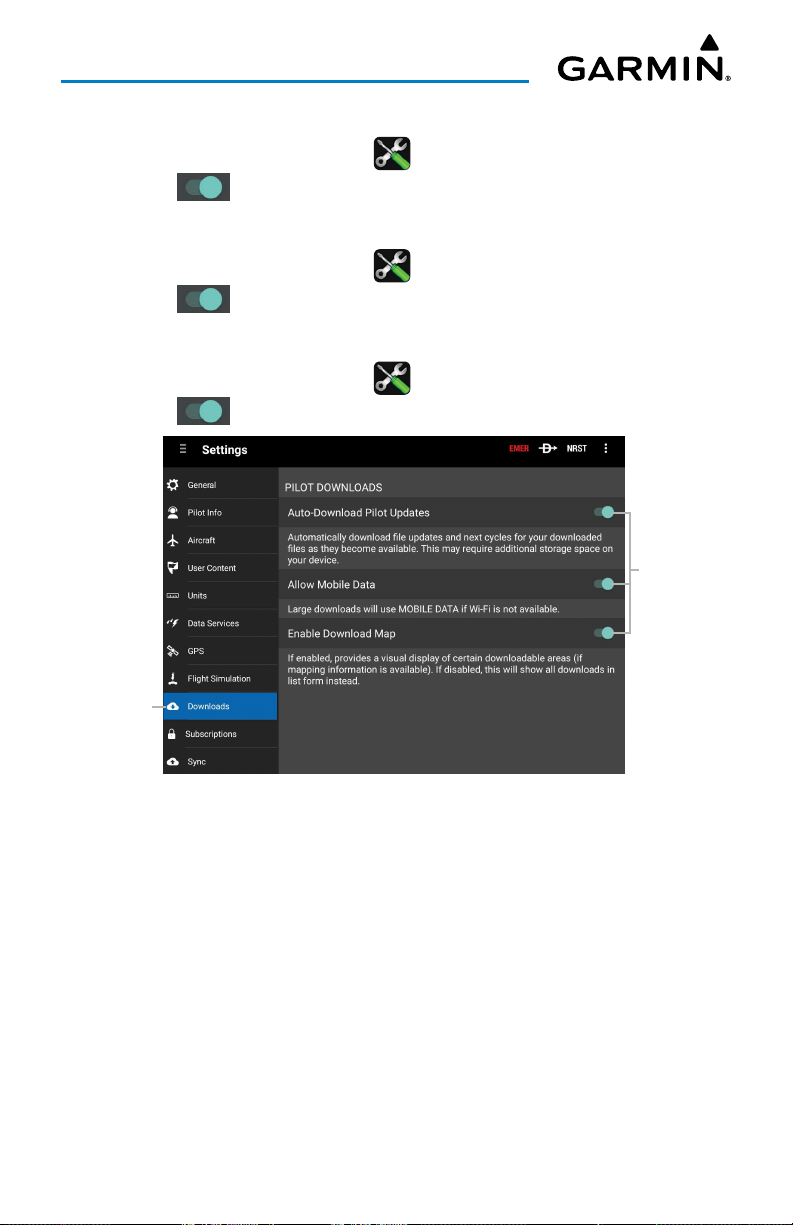
Overview
Configuring Auto-Download Pilot Updates:
1)
From any page, touch
2)
Touch next to
Home
>
> Downloads
Auto-Download Pilot Updates
Configuring Allow Mobile Data:
Tab.
, as desired.
1) From any page, touch
2)
Touch next to
Home
>
> Downloads
Allow Mobile Data
Configuring Enable Download Map:
1)
From any page, touch
2)
Touch next to
Touch
to View
Home
>
> Downloads
Enable Download Map
Settings - Downloads
Tab.
, as desired.
Tab.
, as desired.
Touch to
Toggle
On/Off
Garmin Pilot for Android User’s Guide190-01532-00 Rev. U 80
Page 95
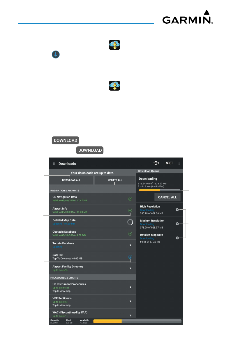
Overview
Downloading US Navigation Data, Airport Info or SafeTaxi:
1)
From any page, touch
2)
Touch to begin downloading the desired information.
Home
> .
Downloading Current Cycle Sectional, IFR Low Altitude, or IFR High
Altitude Charts:
1)
From any page, touch
2)
From the
VFR / IFR Enroute Charts
Home
> .
list select the submenu for the desired
chart.
3)
Touch
Current
4)
Touch the outlined area on the Chart Selection Screen for the desired
.
chart(s).
5)
Touch .
Or
:
Select All
Download
All Button
Update All
Button
> to download all available charts.
Update
Progress
Data Updated
Update Status
Data
Available to
Download
Device
Capacity Info
Queued
Download
Status &
Estimated
Time
Remaining
Touch
For Info
Downloads Page
Garmin Pilot for Android User’s Guide190-01532-00 Rev. U 81
Page 96
Overview
Downloading Next Cycle Sectional, IFR Low Altitude, or IFR High
Altitude Charts:
NOTE:
Sectional Charts are updated individually on the chart schedule and
are available for download, typically 5 days prior to their valid date. IFR Low
and High Altitude Charts are updated on a 28-day cycle and are available for
download typically 5 days prior to their valid date.
1)
From any page, touch
2)
From the
chart.
3)
Touch selected chart type.
4)
Touch the outlined area on the Chart Selection Screen for the desired
chart(s).
5)
Touch to download the selected chart(s). The download will
begin immediately as shown in the Download Queue.
Or
VFR/IFR Enroute Charts
: Touch
Select All
Home
> .
list select the submenu for the desired
> , to download all available charts.
Downloading Current Cycle Instrument Procedures:
1)
From any page, touch
2)
From the
Instrument Procedures
3)
Touch
4)
Touch the State(s) on the Chart Selection Screen for the desired chart(s).
VFR/IFR Enroute Charts
Current
.
Home
.
> .
list select the submenu for the desired
US
5)
Touch to download the selected chart(s). The download will
begin immediately as shown in the Download Queue.
Or
: Touch
Select All
> , to download all available charts.
Downloading Next Cycle Instrument Procedures:
1)
From any page, touch
2)
From the Procedures & Charts list select the submenu for US Instrument
Procedures.
3)
Touch
Current
4)
Touch the State(s) on the Chart Selection Screen for the desired chart(s).
5)
Touch to download the selected chart(s).
Or: Select All
.
> , to download all available charts.
Home
> .
Garmin Pilot for Android User’s Guide190-01532-00 Rev. U 82
Page 97
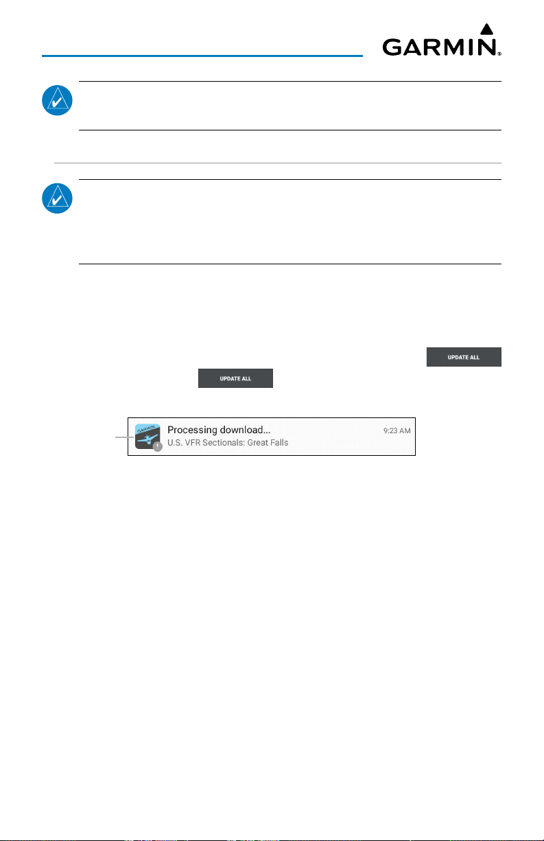
Overview
NOTE:
available for download typically 5 days prior to their valid date.
US Instrument Procedures are updated on a 28-day cycle and are
CHART UPDATES
NOTE:
saved to the device are up-to-date prior to each flight. With the availability of
electronic charts, it is still advisable to carry another source of charts onboard
the aircraft.
Garmin Pilot makes it easy to ensure that charts are always up-to-date by taking
advantage of the notification area of the Android device. When Garmin Pilot is started
it automatically checks for charts updates. When updates are available the Garmin Pilot
Icon is displayed in the notification area the device. The number of available updates is
also displayed on the Downloads Page. When updates are available, the
button becomes active. The button will update all available charts no
matter the chart type.
Downloads
Notification
Electronic Charts are updated frequently. Always ensure the charts
New Downloads Available
US Navigation Data, Airport Info and SafeTaxi are updated on 28-day cycle and are
available for download typically 5 days prior to their valid date.
WAC and Sectional Charts are updated individually on the chart schedule and are
available for download typically 5 days prior to their valid date.
US Instrument Procedures are updated on a 28-day cycle and are available for
download typically 5 days prior to their valid date.
IFR Low and High Altitude Charts are updated on a 28-day cycle and are available
for download typically 5 days prior to their valid date.
Charts that have been downloaded to the device are always available for viewing
even after their expiration date. If the next cycle chart is downloaded prior to its
activation date the current cycle will be used until it expires. After the expiration date
the next cycle chart will be used and the old cycle will automatically be removed.
Garmin Pilot for Android User’s Guide190-01532-00 Rev. U 83
Page 98
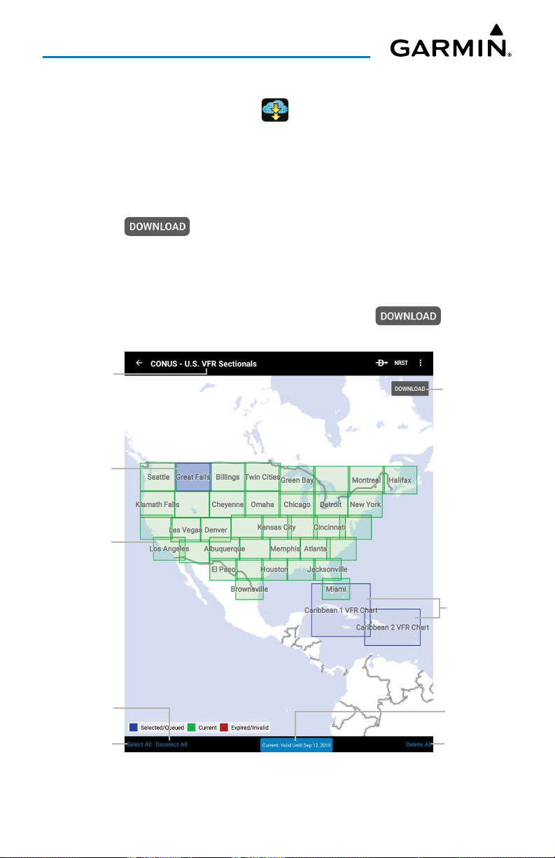
Overview
Updating Sectional, IFR Low, or IFR High Altitude Charts:
1)
From any page, touch
2)
Touch
Update All (X)
Or
:
1)
Select the desired chart type submenu.
2)
From the Chart Selection Screen touch the expired chart(s), shown in red.
3)
Touch to download the selected chart(s). The download will
Home
> .
to update all available charts.
begin immediately as shown in the Download Queue.
Or
:
1)
Select the desired chart type submenu.
2)
From the Chart Selection Screen touch
Select All
> . The
download will begin immediately as shown in the Download Queue.
Data Selection
Chart Selected
Chart
Onboard
& Current
Deselect
All Charts
Select All
Charts
Download
Selected
Chart
Chart
Available For
Download
Chart
Validity
Delete All
Downloads
U.S. VFR Chart Selectionals
Garmin Pilot for Android User’s Guide190-01532-00 Rev. U 84
Page 99
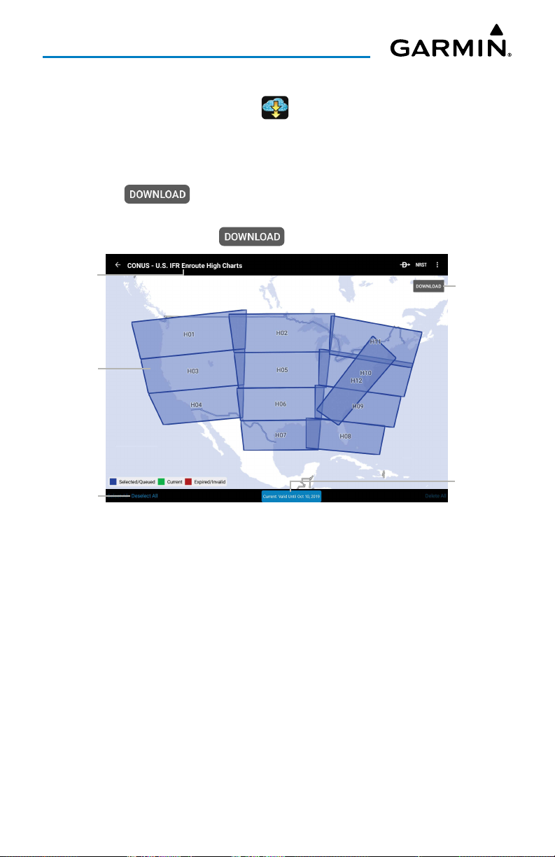
Overview
Updating Instrument Procedures:
1)
From any page, touch
2)
From the
Procedures
3)
From the Chart Selection Screen touch the expired chart(s), shown in red.
4)
Touch to download the selected chart(s). The download will
Procedures & Charts
.
Home
begin immediately as shown in the Download Queue.
Or
: Touch
Select All
> , to update any expired charts.
> .
list select the submenu for
US Instrument
Data
Selection
All Charts
Selected
Touch to
Deselect All
Download
Selected
Charts
Chart
Validity
IFR Enroute High Chart Selection (Select All)
Garmin Pilot for Android User’s Guide190-01532-00 Rev. U 85
Page 100
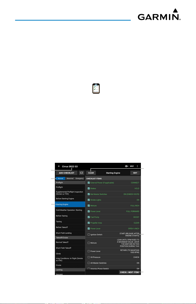
Overview
CHECKLISTS
Electronic checklists can be viewed in Garmin Pilot to ensure proper flight procedures.
Checklists display the item with the preferred state or outcome, along with a green
checkmark to confirm the step has been completed. Checklists are fully customizable
to meet the pilot's preferences.
Viewing an aircraft checklist:
1)
From any page, touch
2)
Touch the desired aircraft model from the Garmin library under
Binders
Or
:
Add a new checklist binder by manually entering the information from the
aircraft's Pilot Operating Handbook (POH), into Gamin Pilot or flyGarmin.
3)
Touch the desired procedure.
4)
Touch the appropriate step to indicate that is has been completed. A blue
checkmark will indicate the step has been completed.
5)
Touch the
selected checklist category.
Clear
Home
> .
Checklist
button to clear all of the completed checklist items in the
Current Aircraft
Touch to Select
Category
Touch to View
Checklist
Touch to Clear All
Touch to Select/
Deselect
Touch to Check Item
Electronic Checklists
Garmin Pilot for Android User’s Guide190-01532-00 Rev. U 86
 Loading...