

Page 1
nüLink!™ 1695
owner’s manual
01102436
Page 2

© 2010 Garmin Ltd. or its subsidiaries Model number: 01102436
All rights reserved. Except as expressly provided herein, no part of this manual may be reproduced,
copied, transmitted, disseminated, downloaded or stored in any storage medium, for any purpose without
the express prior written consent of Garmin. Garmin hereby grants permission to download a single copy
of this manual onto a hard drive or other electronic storage medium to be viewed and to print one copy of
this manual or of any revision hereto, provided that such electronic or printed copy of this manual must
contain the complete text of this copyright notice and provided further that any unauthorized commercial
distribution of this manual or any revision hereto is strictly prohibited.
Information in this document is subject to change without notice. Garmin reserves the right to change
or improve its products and to make changes in the content without obligation to notify any person
or organization of such changes or improvements. Visit the Garmin Web site (www.garmin.com) for
current updates and supplemental information concerning the use and operation of this and other Garmin
products.
Garmin®, the Garmin logo, and MapSource® are trademarks of Garmin Ltd. or its subsidiaries, registered
in the USA and other countries. myGarmin™, myGarmin Agent™, Garmin Lock™, Hotx™, nüLink!™,
nüMaps Guarantee™, nüMaps Lifetime™, ecoRoute™, cityXplorer™, trafcTrends™, myTrends™,
nüRoute™, and Ciao!™ are trademarks of Garmin Ltd. or its subsidiaries. These trademarks may not be
used without the express permission of Garmin.
The Bluetooth® word mark and logos are owned by the Bluetooth SIG, Inc., and any use of such
name by Garmin is under license. microSD™ is a trademark of SanDisk or its subsidiaries. Windows®
and Windows NT® are registered trademarks of Microsoft Corporation in the United States and other
countries. Mac® is a trademark of Apple Computer, Inc., registered in the U.S. and other countries.
Page 3

Table of Contents
Table of Contents
Getting Started .................... 1
About Your Device ..................... 1
Using the Main Menu................. 1
About the Main Menu Toolbar .... 2
Setting Up Your Device.............. 2
Transportation Modes ................ 4
Adjusting the Screen Brightness 4
Locking the Screen .................... 5
Powering Off Your Device .......... 5
Resetting Your Device ............... 5
Adjusting the Volume ................. 5
Navigating the Screens ............. 5
Using the On-Screen
Keyboard ................................. 6
About Points of Interest ............. 6
Navigating Off Road .................. 8
Taking a Detour ......................... 9
Stopping the Route .................... 9
Finding Locations ............. 10
Finding an Address .................. 10
nüLink! 1695 Owner’s Manual iii
Using the Go! Page ..................11
Setting a Home Location ......... 12
Viewing a List of Recently
Found Locations ................... 14
Finding a Destination Using
Phone Book Listings ............. 14
Finding Fuel Prices .................. 15
Checking Movie Times ............ 15
Finding Local Events .............. 15
Finding Parking........................ 15
Finding an Intersection ............ 16
About Favorites ....................... 16
Planning a Trip......................... 17
Using the Map Buttons ............ 19
Browsing the Map by Touching
the Screen ............................. 19
Sending Found Places to Your
Device ................................... 19
Simulating a Route to a
Location ................................ 20
Entering Coordinates ............... 20
Page 4

Table of Contents
About the Map Pages ....... 21
Viewing the Map While
Navigating ............................. 21
Viewing Trip Information ......... 22
Viewing the Turn List .............. 22
Viewing the Next Turn ............. 23
Viewing the Junction View ....... 23
Using the Pedestrian
Navigation Map ..................... 24
About Trafc ..................... 25
About the Trafc Icon............... 25
Trafc on Your Route ............... 26
Viewing the Trafc Map ........... 26
Searching for Trafc Delays .... 26
Disabling Trafc ...................... 27
About Offers ............................ 27
About nüLink! Services ... 28
Purchasing Additional nüLink!
Services ................................ 28
Checking Your nüLink! Store
Account Status ...................... 28
Renewing nüLink! Services ..... 29
iv nüLink! 1695 Owner’s Manual
Viewing myGarmin
Messages .............................. 29
About Safety Cameras ............ 29
About the Hands-Free
Features............................. 31
Pairing Using Your Phone
Settings ................................. 31
Receiving a Call ...................... 32
Using the Device During a
Call ....................................... 33
Accessing the Phone Menu ..... 33
About Ciao!™ .................... 36
About Ciao! Networks .............. 36
Enabling Ciao! ......................... 36
About the Ciao! Friend List ...... 36
Updating Your Ciao! Status
Message ............................... 37
Updating Your Ciao! Status
Message on Social
Networking Sites ................... 37
Changing Your Ciao!
Visibility ................................. 38
Page 5

Table of Contents
Accepting or Declining a Ciao!
Invitation ................................ 38
Inviting a Friend by Phone
Number ................................. 38
Inviting a Friend by E-mail
Address ................................. 39
Viewing a Friend’s Ciao!
Details ................................... 39
Viewing the Location of a
Friend .................................... 39
Removing a Friend .................. 40
Disabling Ciao! ........................ 40
Data Management ............. 41
Compatible File Types ............. 41
About Memory Cards............... 41
Connecting Your Device to Your
Computer .............................. 42
Using the Tools ................. 44
Accessing the Device
Settings ................................. 44
Viewing Current Location
Information ............................ 44
Using Help ............................... 44
About ecoRoute™ .................... 44
Using ecoRoute ....................... 45
Viewing Weather
Information ............................ 48
Viewing Flight Information ....... 49
Using the Picture Viewer ......... 50
Using the Currency
Converter .............................. 51
Using the World Clock ............ 51
Using the Calculator ................ 52
Using the Unit Converter ........ 52
Transferring Files to Your
Computer .............................. 42
Deleting Files from Your
Device .................................. 43
nüLink! 1695 Owner’s Manual v
Page 6

Table of Contents
Customizing the Device ... 53
System Settings....................... 53
Automobile Navigation
Settings ................................. 54
Changing the Map
Perspective ........................... 55
Proximity Points Settings ..... 55
Route Preferences................... 56
About trafcTrends™ ...................57
About myTrends™ .......................57
Pedestrian Navigation Settings 58
Display Settings ....................... 59
Language Settings................... 60
Restoring the Original Device
Settings ................................. 60
Appendix ........................... 61
Mounting on Your
Dashboard ............................ 64
Removing the Device and
Mount .................................... 65
nüMaps Guarantee™ ............... 66
nüMaps Lifetime™ ................... 66
Purchasing Additional Maps .... 66
About Extras ............................ 66
Garmin Travel Guide ............... 67
Contacting Garmin Product
Support ................................. 67
Registering Your Device .......... 68
Updating the Software ............. 68
Specications .......................... 69
Troubleshooting ....................... 70
Index .................................. 72
About GPS Satellite Signals .... 61
Caring for Your Device ............ 61
Enabling Garmin Lock™ ........... 62
Calibrating the Screen ............. 63
Clearing User Data .................. 64
Battery Information ................. 64
vi nüLink! 1695 Owner’s Manual
Page 7
Getting Started
About Your Device
WARNING
See the Important Safety and Product
Information guide in the product
box for product warnings and other
important information.
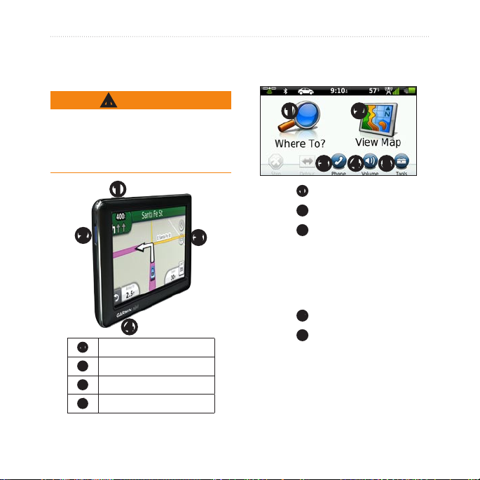
➊
➋
➌
➍
Power key
➊
microSD™ card slot
➋
Microphone
➌
Micro-USB connector
➍
Getting Started
Using the Main Menu
➊ ➋
➌ ➍ ➎
Touch ➊ to nd a destination.
•
Touch ➋ to view the map.
•
Touch ➌ to make a call when
•
connected to a compatible mobile
phone.
See www.garmin.com/bluetooth
for more information.
Touch ➍ to adjust the volume.
•
Touch ➎ to use tools such as
•
settings, help, and weather.
nüLink! 1695 Owner’s Manual 1
Page 8
Getting Started
About the Main Menu Toolbar
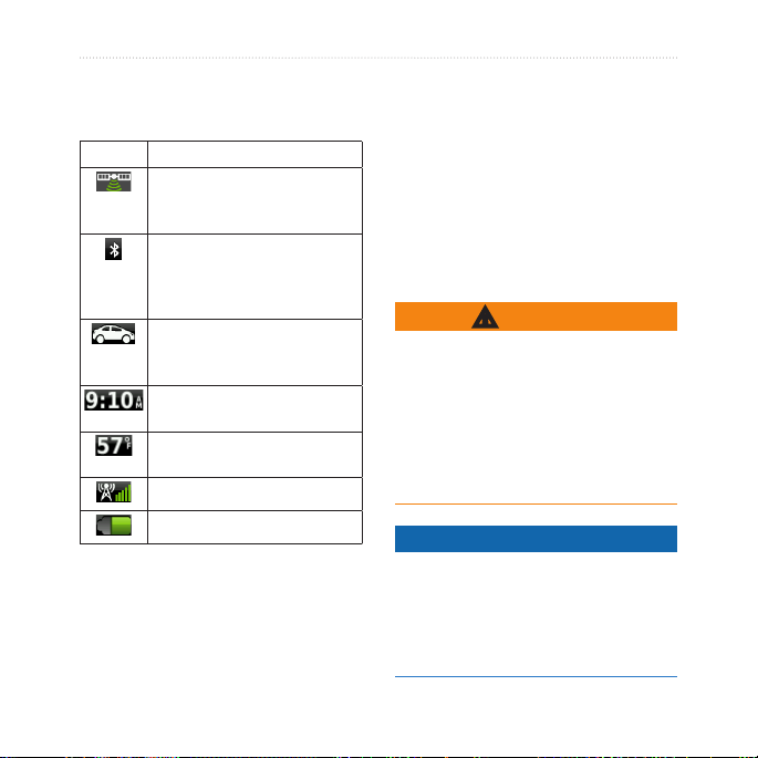
Icon Description
GPS signal status. Touch
and hold to view satellite
information.
Bluetooth® technology status
(appears when connected to
a compatible device. Touch to
change Bluetooth settings).
Transportation mode
indicator. Touch to select a
transportation mode.
Current time. Touch to change
time settings.
Current temperature. Touch to
view weather information.
nüLink! services signal status.
Battery status.
Setting Up Your Device
When using the device for the rst
time, complete these tasks.
1. Mount the device.
2. Charge the device (page 3).
3. Acquire satellites (page 4).
Mounting Your Device
WARNING
This product contains a lithium-ion
battery. To prevent the possibility of
personal injury or product damage
caused by battery exposure to
extreme heat, remove the device
from the vehicle when exiting or
store it out of direct sunlight.
NOTICE
Before mounting the device, see
the Important Safety and Product
Information guide for information
about laws pertaining to windshield
mounting.
2 nüLink! 1695 Owner’s Manual
Page 9
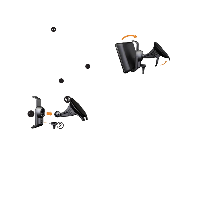
Getting Started
1. Remove the clear plastic from the
suction cup ➊.
2. Place the suction cup on the
windshield.
3. Flip the lever back toward the
windshield.
4. Plug the vehicle power cable ➋
into the back of the cradle.
5. Snap the cradle ➌ onto the
suction cup arm.
➊
➌
➋
6. Plug the other end of the vehicle
power cable into a power outlet
in your vehicle.
7. Fit the bottom of your device into
the cradle.
nüLink! 1695 Owner’s Manual 3
8. Tilt your device back until it
snaps into place.
Charging Your Device
Charge your device for at least 4
hours before using it on battery
power.
Your device can be powered three
ways.
Connect the vehicle power cable
•
to the mount while the device is
in the mount.
Connect the USB cable.
•
Connect an AC adapter (available
•
on some device models).
Page 10
Getting Started
Acquiring Satellites
To navigate with your device, you
must acquire satellites.
1. Turn on your device.
2. If necessary, go outdoors to
an open area, away from tall
buildings and trees.
Acquiring satellite signals can take a
few minutes.
a route that uses a combination
of public transit options, such as
riding a bus or subway, and walking.
cityXplorer maps are not included
with your device.
Go to www.garmin.com to purchase
cityXplorer maps.
Changing Your
Transportation Mode
1. Touch the transportation mode
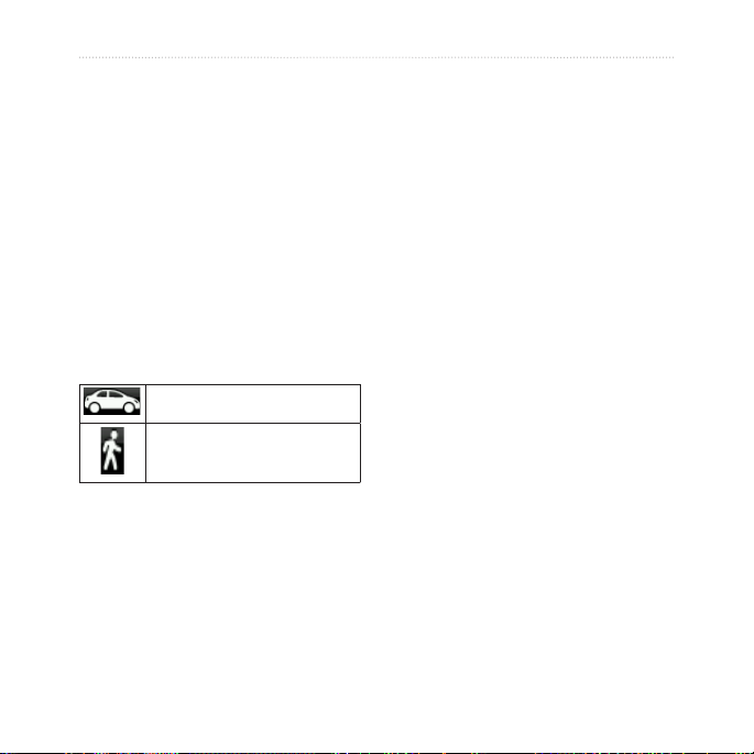
Transportation Modes
Automobile mode
Pedestrian mode
icon.
2. Touch a mode.
3. Touch Save.
Adjusting the Screen
Your device offers several
transportation modes for navigation
methods. Routing is calculated
differently based on your
transportation mode. For example, in
Pedestrian mode with cityXplorer™
maps loaded, your device calculates
4 nüLink! 1695 Owner’s Manual
Brightness
1. Press and quickly release the
Power key.
2. Touch and drag the scroll bar to
adjust screen brightness.
Page 11
Getting Started
Locking the Screen
1. Press and quickly release the
Power key.
2. Touch Lock Screen to prevent
accidental screen touches.
Powering Off Your Device
1. Press and quickly release the
Power key to view additional
options.
2. Touch Power Off to turn off your
device. You can also turn off the
device by holding the Power key
for two seconds.
Resetting Your Device
You can reset your device if it stops
functioning.
Press and hold the Power key for
10 seconds.
nüLink! 1695 Owner’s Manual 5
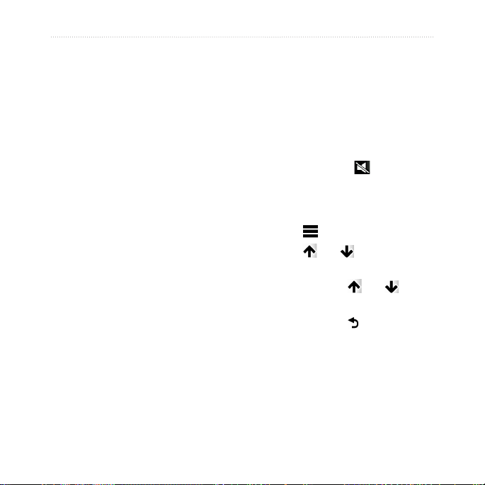
Adjusting the Volume
1. From the main menu, touch
Volume.
2. Use the slider bar to adjust the
volume.
Muting the Audio
Touch Volume > to mute all
audio.
Navigating the Screens
Touch to view more options.
•
Touch and to see more
•
choices.
Touch and hold and to
•
scroll faster.
Touch and hold to quickly
•
return to the main menu.
Page 12

Getting Started
Using the On-Screen Keyboard
NOTE: See “Customizing the
Device” to change the keyboard
layout (page 53).
Touch a character on the
•
keyboard to enter a letter or
number.
Touch to add a space.
•
Touch in the text eld to move
•
the cursor.
Touch to delete a character.
•
Touch and hold to erase the
•
entire entry.
Touch to select the keyboard
•
language mode.
Touch to enter special
•
characters, such as punctuation
marks.
6 nüLink! 1695 Owner’s Manual
About Points of Interest
The detailed maps loaded in your
device contain millions of points of
interest (POIs), such as restaurants,
hotels, and auto services.
Finding a Point of Interest by
Category
1. From the main menu, touch
Where To? > Points of Interest.
2. Touch a category.
3. If necessary, touch a subcategory.
TIP: To narrow the search, touch
, enter text, and touch Done.
A list of items near your current
location appears.
4. Touch an item.
Page 13

Getting Started
Finding a Point of Interest by
Spelling the Name
Local Search may not be available in
all areas or countries.
1. From the main menu, touch
Where To? > Points of Interest
> Local Search.
2. Enter all or part of the name.
3. Touch Done.
4. Select an option:
Touch a Local Search result.
•
Touch the Garmin tab to
•
search the Garmin map data
loaded on your device.
5. Touch an item.
Finding Points of Interest in
Pedestrian Mode
While in Pedestrian mode in certain
cities, you may use cityXplorer maps
to navigate using public transit.
Go to www.garmin.com to purchase
cityXplorer maps.
1. Select Pedestrian transportation
mode (page 4).
2. From the main menu, touch
Where To? > Points of Interest.
3. Touch a category.
4. If necessary, touch a subcategory.
5. Touch an item.
6. Select an option:
Touch Drive to calculate a
•
route you will navigate by
driving.
Touch Walk to calculate a
•
route you will navigate by
walking.
nüLink! 1695 Owner’s Manual 7
Page 14

Getting Started
Touch Public Transit (if
•
available) to calculate a route
that uses public transit and
walking.
7. Touch Go!.
Adding a Points to the Active
Route
1. While navigating a route, touch
to return to the main menu.
2. Touch Where To?.
3. Touch a category.
4. If necessary, touch a subcategory.
5. Touch a destination.
6. Touch Go! > Add to Current
Route to add the new destination
to the active route as a point of
interest, also called a via point.
Changing the Destination of
the Active Route
1. While navigating a route, touch
to return to the main menu.
2. Touch Where To?.
3. Search for the location.
4. Touch Go! > Start New Route.
Navigating Off Road
If you are not following roadways as
you navigate, use Off Road mode.
1. From the main menu, touch
Tools > Settings > Navigation
> Automobile > nüRoute >
Calculation Mode.
2. Touch Off Road > Save.
8 nüLink! 1695 Owner’s Manual
Page 15

Getting Started
Taking a Detour
While navigating a route, you can
use detours to avoid obstacles ahead
of you, such as construction zones.
1. While navigating a route, touch
to return to the main menu.
2. Touch Detour (or Recalculate in
Pedestrian mode).
If the route you are currently taking
is the only reasonable option, the
device might not calculate a detour.
nüLink! 1695 Owner’s Manual 9
Stopping the Route
1. While navigating a route, touch
to return to the main menu.
2. Touch Stop.
Page 16

Finding Locations
Finding Locations
The Where To? menu provides
several different categories you
can use to search for locations. To
perform a simple search, see page 6.
Finding an Address
NOTE: Depending on the version of
the maps loaded on your device, the
button names and the order of steps
could be different from the steps
below.
1. From the main menu, touch
Where To? > Address.
2. If necessary, change the state,
country, or province.
3. Touch Spell City.
4. Enter the name of the city.
5. Touch Done.
6. If necessary, touch the city/postal
code.
10 nüLink! 1695 Owner’s Manual
NOTE: Not all map data
provides postal code searching.
7. Enter the number of the address.
8. Touch Done.
9. Enter the street name.
10. Touch Done.
11. If necessary, touch the street.
12. If necessary, touch the address.
Page 17
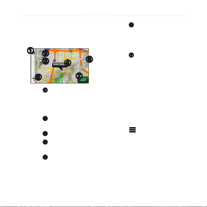
Using the Go! Page
The Go! page opens when you select
a location.
➊
➋
➌
➍
➏
Touch ➊ to call the selected
•
location when your device is
connected to a phone, or to save
the location to your favorites.
Touch ➋ to switch between 2-D
•
and 3-D view.
Touch ➌ to rotate the view.
•
Touch ➍ to view more
•
information for the location.
Touch ➎ to zoom in and out.
•
➎
➐
Finding Locations
Touch ➏ to return to the previous
•
page.
Touch and hold to return to the
main menu.
Touch ➐ to create a turn-by-turn
•
route to this location.
Reporting an Incorrect Point
of Interest
When your search results contain
an outdated or incorrect point of
interest, you can remove the location
from future searches.
1. From the Go! page, touch the
information balloon.
2. Touch > Report Error > Yes.
The location is removed from future
searches.
nüLink! 1695 Owner’s Manual 11
Page 18

Finding Locations
Editing the Phone Number for
a Point of Interest
If your search results contain an
outdated or incorrect phone number
for a point of interest, you can edit
the phone number.
the point of interest appear to the
left of Go!.
2. Touch the stars to rate the point
of interest.
The star rating updates on your
device.
1. From the Go! page, touch the
information balloon.
2. Touch > Edit Phone
Number.
3. Enter the phone number.
4. Touch Done.
The phone number updates on
your device.
Rating a Point of Interest
When available, you can view and
change the star rating for a point of
interest.
1. From the Go! page, touch the
information balloon.
Setting a Home Location
You can set your home location for
the location you return to most often.
1. From the main menu, touch
Where To? > Go Home.
2. Select an option to set your home
location:
Touch Enter My Address to
•
enter your home address.
Touch Use My Current
•
Location to set your current
location as your home
location.
If available, the star ratings for
12 nüLink! 1695 Owner’s Manual
Page 19

Touch Recently Found to set
•
a recently found location as
your home location.
Going Home
Before you can navigate to home,
you must set a home location.
From the main menu, touch
Where To? > Go Home.
Resetting Your Home
Location
1. From the main menu, touch
Where To? > > Set Home
Location.
2. Touch an option to change your
address.
Editing Your Home Location
1. From the main menu, touch
Where To? > Favorites > Home.
2. Touch Edit.
3. Enter your changes.
4. Touch Done.
Finding Locations
Searching for a Location in a
Different Area
1. From the main menu, touch
Where To? > > Near.
2. Touch a search area:
Touch Where I Am Now to
•
search for places near your
current location.
Touch A Different City to
•
search for places near the city
you enter.
Touch A Recent Destination
•
to search near a recently
found location.
Touch Favorite Destination
•
to search near a Favorite
destination.
Touch My Current Route to
•
search for places along your
current route.
nüLink! 1695 Owner’s Manual 13
Page 20

Finding Locations
Touch My Destination to
•
search for places near your
current route destination.
Viewing a List of Recently Found Locations
Your device stores the last 50
locations you have found.
From the main menu, touch
Where To? > Recently Found.
Clearing the List of Recently
Found Locations
From the main menu, touch
Where To? > Recently Found >
> Yes.
Finding a Destination Using Phone Book Listings
Phone book listings may not be
available in all areas or countries.
1. From the main menu, touch
Where To? > White Pages.
2. Select an option:
Touch By Name to search for
•
a listing using rst and last
names.
Touch By Phone Number
•
to search for a listing using a
phone number.
3. Enter a name or a phone number.
4. Touch Done.
5. If necessary, touch a listing in the
search results.
14 nüLink! 1695 Owner’s Manual
Page 21

Finding Locations
Finding Fuel Prices
Fuel prices may not be available in
all areas or countries.
1. From the main menu, touch
Where To? > Fuel Prices.
2. Touch > Fuel Type.
3. Touch a fuel type.
4. Touch Save.
A list of fuel prices at nearby gas
stations appears.
5. Touch a gas station.
Checking Movie Times
Movie times may not be available in
all areas or countries.
1. From the main menu, touch
Where To? > Movie Times.
2. Touch > Select Day.
3. Touch an upcoming day.
4. Touch Find By Movie Title or
Find by Theater Name.
nüLink! 1695 Owner’s Manual 15
5. Touch a movie title or a theater
name.
Finding Local Events
Local events may not be available in
all areas or countries.
1. From the main menu, touch
Where To? > Local Events.
2. Touch > Select Day.
3. Touch a category.
4. Touch an event.
Finding Parking
1. From the main menu, touch
Where To? > Parking > Find
Parking.
2. Touch a parking location.
Page 22

Finding Locations
Finding Your Last Parking
Spot
The device saves your parking spot
when you remove the device from
the mount while it is operating on
external power.
From the main menu, touch
Where To? > Parking > Last
Spot.
Finding an Intersection
1. From the main menu, touch
Where To? > Intersection.
2. Select an option:
Touch State or Country to
•
select a different country,
state, or province.
Touch Spell City to enter the
•
name of a city.
Touch Search All to search
•
all cities in the selected
country, state, or province.
16 nüLink! 1695 Owner’s Manual
3. Enter the rst street name.
4. Enter the second street name.
5. If necessary, touch an intersection
in the list.
About Favoritesvorites
You can save places in your
Favorites so you can quickly nd
them and create routes to them.
Your home location is also stored in
Favorites.
Saving Your Current Location
to Favorites
1. From the map page, touch the
vehicle icon.
2. Touch Save.
3. Enter a name.
4. Touch Done.
The location is saved in Favorites.
Page 23

Finding Locations
Saving Locations to
Favorites
1. Search for the location (page 6).
2. From the Go! page, touch >
Save > OK.
Finding Favorites
1. From the main menu, touch
Where To?.
2. If necessary, touch a category.
3. Touch a saved location.
Editing Favorites
1. From the main menu, touch
Where To? > Favorites.
2. Touch a category.
3. Touch a favorite.
4. Touch the information balloon.
Planning a Trip
You can use the Trip Planner to
create and save a trip with multiple
destinations.
1. From the main menu, touch
Where To? > Trip Planner.
2. Touch .
3. Touch Select Start Location.
4. Find a location for your starting
point.
5. Touch Select.
6. Touch to add additional
locations to your map.
7. Touch Next.
8. Enter a name for your trip.
9. Touch Done.
5. Touch > Edit.
6. Select an option:
7. Edit the information.
8. Touch Done.
nüLink! 1695 Owner’s Manual 17
Page 24

Finding Locations
Scheduling a Trip
Trip Planner allows you to set a
departure time and trip duration.
1. From the main menu, touch
Where To? > Trip Planner.
2. Touch a trip.
3. Touch a location.
4. Touch Departure Time (or
Arrival Time if the location is
not the rst stop in the trip).
5. Touch a date and time.
6. Touch Save.
7. Touch Duration.
8. Select the amount of time you
will spend at the location.
9. Touch Save.
10. If necessary, repeat steps 2–7 for
each location.
Navigating a Saved Trip
1. From the main menu, touch
Where To? > Trip Planner.
2. Touch a trip.
3. Touch Go!.
Editing a Saved Trip
1. From the main menu, touch
Where To? > Trip Planner.
2. Touch a trip.
3. Touch .
4. Select an option:
Touch Edit Destinations to
•
add or delete locations.
Touch Optimize Order to
•
arrange your trip locations in
the most-efcient order.
Touch Delete Trip to delete
•
the entire trip.
Touch Rename Trip to edit
•
the trip name.
18 nüLink! 1695 Owner’s Manual
Page 25

Finding Locations
Tap the map twice to zoom in
Using the Map Buttons
1. From the main menu, touch
Where To? > Browse Map.
2. Touch anywhere on the map.
Touch and to zoom in
•
and out.
Touch to switch between
•
2-D and 3-D views.
Touch to rotate the view.
•
Browsing the Map by
•
and center on a location.
Finding a Location Using the
Map
1. From the main menu, touch
Where To? > Browse Map.
2. Touch a location.
An information balloon appears
next to the location.
3. Touch the information balloon.
4. Touch Go!.
Touching the Screen
From the main menu, touch
Where To? > Browse Map.
Touch an area on the map to
•
select a location.
An information balloon
appears next to the location.
Touch and drag the map to
•
view different parts of the
map.
nüLink! 1695 Owner’s Manual 19
Sending Found Places to Your Device
You can send locations to your
device from various online sources,
including http://connect.garmin.com.
1. Find a location on a supported
Web site.
2. Follow instructions on the Web
site to send the location to your
myGarmin™ account.
Page 26

Finding Locations
3. Connect your device to your
computer using a USB cable
(page 42) to manually transfer
locations to your device.
Locations sent to your myGarmin
account are transferred automatically
to Favorites (page 16) on your device
through nüLink! services.
Simulating a Route to a Location
1. From the main menu, touch Tools
> Settings > System > GPS
Simulator > On > Save.
2. From the main menu, touch
Where To? > Browse Map.
3. Touch an area on the map.
4. Touch Go!.
20 nüLink! 1695 Owner’s Manual
Entering Coordinates
If you know the geographic
coordinates of your destination, you
can use your device to navigate to
your destination using the latitude
and longitude coordinates. This
can be especially helpful when
geocaching.
1. From the main menu, touch
Where To? > Coordinates.
2. Touch Format to select the
correct coordinate format for the
type of map you are using.
3. Touch the coordinate you want to
adjust.
4. Enter the coordinates.
5. Touch Done.
6. Touch Next.
The coordinates are displayed on
a map.
7. Touch > Set Location.
Page 27

About the Map Pages
About the Map
Pages
Viewing the Map While Navigating
NOTICE
In no event shall Garmin be liable
for any incidental, special, indirect,
or consequential damages, including,
without limitation, damages for any
trafc nes or citations, whether
resulting from the use, misuse,
or inability to use the product or
from defects in the product. Some
states do not allow the exclusion of
incidental or consequential damages,
so the above limitations may not
apply to you.
Your route is marked with a magenta
line. A checkered ag marks your
destination.
nüLink! 1695 Owner’s Manual 21
As you travel, your device guides
you to your destination with voice
prompts, arrows on the map, and
directions at the top of the map. If
you depart from the original route,
your device recalculates the route
and provides new directions.
A speed limit icon displaying the
current speed limit may appear as
you travel on major roadways.
➊ ➋
➌
➐
➏
➍
Touch ➊ to view the next turn or
•
junction view.
Touch ➋ to view the turn list.
•
Touch ➌ to zoom in and out.
•
Touch ➍ to return to the main
•
menu.
➎
➑ ➒
Page 28

About the Map Pages
Touch ➎ to change the data eld.
•
Touch ➏ to view information
•
about your current location.
Touch ➐ and drag the map to
•
view a different area of the map.
Touch ➑ to view trip
•
information.
Touch ➒ to report a safety
•
camera.
Viewing Trip Information
The trip information page displays
your current speed and provides
statistics about your trip.
22 nüLink! 1695 Owner’s Manual
TIP: If you make frequent stops,
leave the device turned on so it can
accurately measure elapsed time
during the trip.
From the map, touch Speed.
Resetting Trip Information
1. From the map, touch Speed >
.
2. Select an option:
Touch Reset Trip Data to
•
reset the trip information.
Touch Reset Max. Speed to
•
reset the maximum speed.
Touch Reset Trip B to reset
•
the odometer.
Viewing the Turn List
While navigating a route, you can
view all of the turns for your entire
route and the distance between turns.
1. While navigating a route, touch
the text bar on the top of the map.
Page 29

About the Map Pages
the turn indicator in the upper-left
corner to view the next turn.
Viewing the Junction View
2. Select an option:
Touch a turn on the list to
•
view the next turn.
Touch > Show Map to
•
view the entire route on the
map.
Viewing the Next Turn
Your next turn shows the turn on the
map along with the distance and time
left before you reach the turn.
While navigating a route, touch
nüLink! 1695 Owner’s Manual 23
On some device models, the junction
view displays a view of some
upcoming junctions and While
navigating a route which lane you
should be driving.
While navigating a route, touch
the turn indicator in the upper-left
corner to view the junction view.
Page 30

About the Map Pages
Using the Pedestrian Navigation Map
➋➊ ➊
➌ ➍
➎ ➎
In Pedestrian mode, your route is
displayed on a two-dimensional map.
Touch ➊ to view the next step in
•
the route.
Touch ➋ to view all of the steps
•
in the route.
Touch ➌ to center the map on
•
your current location
Touch ➍ to zoom in and zoom
•
out.
Touch ➎ to change the data eld.
•
24 nüLink! 1695 Owner’s Manual
Public Transit Options
If you have cityXplorer maps
installed, your device calculates a
route that uses a combination of
public transit options, such as riding
a bus or subway, and walking.
Go to www.garmin.com to purchase
cityXplorer maps.
The , , , , , , and
icons indicate the navigation method
for that section of the route. For
example, when you see , board a
bus at that point in the route.
The black dots on the map are public
transit stops along your route.
Page 31

About Trafc
About Trafc
About the Trafc Icon
When you are receiving trafc
NOTICE
The speed limit icon feature is
for information only and does not
replace the driver’s responsibility to
abide by all posted speed limit signs
and to use safe driving judgment
at all times. Garmin will not be
responsible for any trafc nes or
citations that you may receive for
failing to follow all applicable trafc
laws and signs.
Trafc information may not be
available in all areas or countries.
nüLink! 1695 Owner’s Manual 25
information, a trafc icon
appears on the map. The trafc icon
changes color to indicate the severity
of trafc conditions on your route
or on the road you are currently
traveling.
Color Description Meaning
Green Low severity
Medium
Yellow
severity
Red High severity
Gray No data
Trafc is
owing
normally.
Trafc is
slightly
congested.
Trafc is
heavily
congested or
stopped.
Trafc data
has not
updated.
Page 32

About Trafc
Trafc on Your Route
When calculating your route, the
device examines the current trafc
and automatically optimizes the
route for the shortest time. If a severe
trafc delay occurs on your route
while you are navigating, the device
automatically recalculates the route.
You might still be routed through
trafc if no better alternative routes
exist.
Manually Avoiding Trafc on
Your Route
1. While navigating a route, touch
.
2. Touch Trafc On Route.
3. If necessary, touch the arrows to
view other trafc delays on your
route.
4. Touch > Avoid.
26 nüLink! 1695 Owner’s Manual
Viewing the Trafc Map
The trafc map shows color-coded
trafc ow and delays on nearby
roads.
1. From the map, touch .
2. Touch Trafc Map to view the
trafc incidents on a map.
Searching for Trafc
Delays
1. From the map, touch .
2. Touch Trafc Search to view a
list of trafc delays.
3. Touch an item in the list to view
delays on the road.
4. If there is more than one delay,
touch the arrows to view
additional delays.
Page 33

About Trafc
Disabling Trafc
1. From the main menu, touch Tools
> Settings > System > Position
Reporting > Off.
2. Touch Save.
About Offers
While you are receiving trafc
information, you will receive
location-relevant offers and coupons
with your trafc information. Adbased trafc is only available in
North America.
The trafc receiver must be
connected to external power and you
must be in a coverage area to receive
ad-based trafc information.
Viewing Offers
CAUTION
Do not attempt to write down the
coupon codes while driving.
nüLink! 1695 Owner’s Manual 27
1. Touch an offer that appears
on the screen to search for the
nearest location related to that
offer.
2. If the offer shows an icon, touch
the icon on the Go! page to
receive a coupon code.
3. Write down this code and present
it when you arrive at the location.
Viewing a List of Offers
Received.
Touch Tools > Offers to view a
list of offers you have received.
Disabling Offers
You must disable trafc in order to
disable offers.
1. From the main menu, touch Tools
> Settings > System > Position
Reporting > Off.
2. Touch Save.
Page 34

About nüLink! Services
About nüLink!
Services
nüLink! services may not be
available in all areas or countries.
Your device includes a basic nüLink!
subscription, which is activated
when you rst turn on your device.
nüLink! services allow you to
receive current information on fuel
prices, ight times, and more.
To use these features, you must have
a current nüLink! subscription, and
your device must be receiving a
nüLink! signal.
See www.garmin.com/nulink for
more information.
28 nüLink! 1695 Owner’s Manual
Purchasing Additional nüLink! Services
You can purchase premium nüLink!
services, such as real-time safety
cameras and weather radar.
1. From the main menu, touch Tools
> nüLink!™ Store.
2. Touch an option to view more
details.
3. Touch Upgrade to purchase
premium content.
Checking Your nüLink! Store Account Status
You can check the status of your
nüLink! services subscription,
including the billing status of your
basic subscription and your premium
content.
1. From the main menu, touch
Tools > nüLink!™ Store > >
Account Status.
Page 35

About nüLink! Services
2. Touch an item in the list to view
details.
Renewing nüLink! Services
After your subscription ends, you
can renew your subscription to
continue receiving nüLink! services.
1. From the main menu, touch
Tools > nüLink!™ Store > >
Account Status.
2. Touch an item in the list.
3. Touch Renew.
4. Touch a purchase option:
5. Touch Purchase.
6. Enter your myGarmin password.
Viewing myGarmin Messages
nüLink! services allow you to
receive messages from myGarmin.
nüLink! 1695 Owner’s Manual 29
If you have unread messages, the
number of unread messages appears
in a blue oval on the myGarmin icon.
myGarmin may not be available in
all areas or countries.
1. From the main menu, touch Tools
> myGarmin.
2. Touch a message.
About Safety Cameras
For available locations, the device
includes the locations of hundreds
of safety cameras. Your device alerts
you when you are approaching a
safety camera and can warn you if
you are driving too fast.
You can purchase a new region
or extend an existing subscription
at any time. Each region that you
purchase has an expiration date.
Page 36

About nüLink! Services
Safety Camera Availability
the safety camera database.
Safety camera information may not
be available in all areas or countries.
Check http://my.garmin
.com for availability. Safety
camera information is not available
in Switzerland. Safety camera
information is disabled by default in
Germany and Austria.
Use of the safety camera database
may be a misdemeanor in certain
European countries. Prior to using or
enabling the safety camera database,
inquire about the legal situation and
possible legal consequences of using
this database in the countries in
which you intend to use it.
Garmin International and its afliates
accept no liability for the use of this
safety camera database. Garmin
International and its afliates do not
Reporting Safety Cameras
You can report safety cameras,
including red light cameras and radar
guns, as you encounter them.
From the map, touch >
Report Safety Camera.
NOTE: If does not appear,
you can touch the speed limit
icon to report safety cameras.
The location of the safety camera is
shared with other users.
Turning Off Safety Cameras
1. From the main menu, touch
Tools Settings > Navigation >
Automobile > Alerts.
2. Clear the Garmin Safety
Cameras check box.
3. Touch Save.
warrant or guarantee in any way as
to the accuracy or exhaustiveness of
30 nüLink! 1695 Owner’s Manual
Page 37

About the Hands-Free Features
About the Hands-
Free Features
To use the hands-free features, you
must pair your phone and your
device. For more information, see
www.garmin.com/bluetooth.
Pairing Using Your Phone Settings
Before you can pair and connect,
your phone and the device must be
turned on and within 33 ft. (10 m) of
each other.
1. Enable the Bluetooth component
on your phone.
2. On your device, touch
Tools > Settings > Bluetooth >
Bluetooth.
3. Touch Enabled > Save.
4. Touch Add Phone > OK.
5. Select your phone.
nüLink! 1695 Owner’s Manual 31
6. Touch
7. Enter the device Bluetooth PIN
Pairing Using the Device
Settings
1. From the main menu of the
2. Enable the Bluetooth component
3. Enable Find Me/Discoverable/
4. Touch OK on the device.
5. Select your phone from the list of
6. Touch OK on the device.
7. Enter the device Bluetooth PIN
OK.
(1234) into your phone.
device, touch Tools > Settings >
Bluetooth > Phone > .
on your phone.
Visible mode on your phone.
NOTE: This might be in a
menu called Settings, Bluetooth,
Connections, or Hands-free.
devices.
(1234) in your phone.
Page 38

About the Hands-Free Features
About Paired Devices
After the initial pairing, the
•
two devices can connect
automatically each time you turn
them on.
You might have to set your
•
mobile phone to connect to the
device automatically when it is
turned on.
When your phone is connected
•
to your device, you are ready to
make phone calls.
When you turn on the device, it
•
attempts to connect to the last
phone to which it was connected.
32 nüLink! 1695 Owner’s Manual
Calling a Number
Before you can call a number using
your device, you must pair your
phone and your device.
1. From the main menu, touch
Phone > Dial.
2. Enter the number.
3. Touch Dial.
Receiving a Call
When you receive a call, the
Incoming Call window appears.
Touch Answer to answer the call.
•
Touch Ignore to ignore the call.
•
Page 39

About the Hands-Free Features
Using the Device During a Call
During a call, appears on the
map and Phone appears on the main
menu. Depending on the screen
shown on your device, the In Call
icon could look different.
1. On the map, touch .
2. Select an option:
Touch Use Handset to turn
•
off the device but remain on
the call.
Touch Keypad to view
•
a keypad page for using
automated systems such as
voice mail.
Touch Mute to mute the
•
microphone.
Touch End Call to end the
•
call.
nüLink! 1695 Owner’s Manual 33
Using Call Waiting
When you are on a call and you
receive a second call, the Incoming
Call screen appears.
1. Touch .
2. Touch Switch To.
3. When you are nished with the
call, touch End Call to hang up.
This does not disconnect the call
on hold.
Accessing the Phone Menu
From the main menu, touch
Phone.
NOTE: Not all phones support
all features of the device Phone
menu.
Page 40

About the Hands-Free Features
About Your Phone Book
Each time your phone connects
with the device, the phone book is
automatically loaded into the device.
It can take a few minutes for the
phone book to be available. Phone
book transfer is not available on all
phones.
Dialing a Number
1. From the main menu, touch
Phone > Dial.
2. Enter the number.
3. Touch Dial.
Viewing Your Call History
Each time your phone connects
to the device, your call history is
Using Your Phone Book
1. From the main menu, touch
Phone > Phone Book.
2. Touch the phone book entry
(contact) you want to call.
Dialing a Point of Interest
1. From the main menu, touch
Phone > Points of Interest.
2. Search for the point of interest
you want to call.
3. Touch Call or touch the phone
number.
34 nüLink! 1695 Owner’s Manual
automatically transferred to the
device. It may take a few minutes to
transfer this data to the device.
1. From the main menu, touch
Phone > Call History.
2. Touch a category.
The calls are listed in
chronological order. The most-
recent calls are at the top of the
list.
3. Touch an entry.
4. Touch Dial.
Page 41

About the Hands-Free Features
Entering Your Phone Number
You can enter the phone number you
want the device to call when you
touch Call Home.
1. From the main menu, touch
Phone > Call Home.
Placing Calls Using Voice
Dial
Before you can place calls by
speaking the name of the contact,
you may need to train your phone to
recognize your voice dial commands.
Refer to your phone instructions.
2. Touch Enter Phone Number.
3. Enter the phone number.
4. Touch Done > Yes.
1. From the main menu, touch
Phone > Voice Dial.
2. Speak the contact name.
The device dials your home
phone number.
Calling Home
From the main menu, touch
Checking the Phone Battery
Level and Signal Strength
From the main menu, touch
Phone > Phone Status.
Phone > Call Home.
nüLink! 1695 Owner’s Manual 35
Page 42

About Ciao!
About Ciao!
Ciao! periodically sends your
location to our partner networks and
downloads the most-recent location
of your friends. This application only
submits your location when you tell
it to, unless you enable automatic
updates. See www.garmin.com
/nulink for more information.
Ciao! may not be available in all
areas or countries.
™
Enabling Ciao!
Before you can join Ciao!, you must
register your device (page 68).
1. From the main menu, touch Tools
> Ciao! > Agree.
2. On your computer, go to the URL
that appears on the device screen,
and read the Terms of Service.
3. Touch Continue to accept the
Terms of Service.
About the Ciao! Friend
About Ciao! Networks
CAUTION
Use caution when sharing your
location information with others.
Ciao! may support multiple location-
based social networks.
When you enable Ciao!, the network
or networks you will be registered
with appear in the terms of service.
36 nüLink! 1695 Owner’s Manual
List
When you start Ciao!, the friend list
appears.
If you are receiving updates from a
friend, the distance and direction to
the friend appears on the right side of
the screen.
The status of a friend appears below
their name. If you are receiving
updates from a friend, their custom
Page 43

About Ciao!
status message appears. These
statuses may appear if you are not
receiving updates from a friend.
Invited—You have invited this
•
friend, but he or she has not yet
accepted your invitation.
Pending—This friend has
•
invited you, but you have not yet
accepted his or her invitation.
Hidden—This friend has
•
temporarily disabled updates.
Updating Your Ciao! Status Message
1. From the main menu, touch Tools
> Ciao! > > Update.
2. Enter a status message with up to
255 characters.
3. Touch Done.
nüLink! 1695 Owner’s Manual 37
Updating Your Ciao! Status Message on Social Networking Sites
NOTE: You must set up and
congure your social networking
sites on myGarmin before you can
publish your status to them using
Ciao!.
1. From the main menu, touch Tools
> Ciao! > > > Publishing
Settings.
2. Select the name of the social
networking site.
3. Touch Done.
Page 44

About Ciao!
Changing Your Ciao! Visibility
You can choose whether to send
location updates to your Ciao!
friends by changing your visibility.
From the main menu, touch Tools
•
> Ciao! > > > Hide >
Yes.
Your friends will not be able to
view your location and status
information.
Touch > Show > Yes to make
•
your information visible again.
Accepting or Declining a Ciao! Invitation
1. From the main menu, touch Tools
> Ciao!.
2. Touch the friend who sent you
the invitation.
3. Touch Accept or Decline.
38 nüLink! 1695 Owner’s Manual
Inviting a Friend by Phone Number
1. From the main menu, touch Tools
> > Invite by phone number.
2. Enter the name of the country
where your friend is located.
3. Touch a country.
4. Touch Save.
5. Enter a phone number in the
proper format for the country you
selected.
For example, for the United
States, enter a ten-digit phone
number, including the area code.
6. Touch Done.
7. Touch Send Invite.
The friend you invited appears in
your friends list. Your friend must
accept your invitation before you
can view your friend’s location.
Page 45

About Ciao!
Inviting a Friend by E-mail Address
1. From the main menu, touch Tools
> Ciao! > > Invite by E-mail
address.
2. Enter the e-mail address that your
friend has registered with Ciao!.
3. Touch Done.
The friend you invited appears in
your friends list. Your friend must
accept your invitation before you
can view your friend’s location.
Viewing a Friend’s Ciao! Details
1. From the main menu, touch Tools
> Ciao!. The friends list appears.
2. Touch a friend in the list.
nüLink! 1695 Owner’s Manual 39
Viewing the Location of a Friend
1. From the main menu, touch Tools
> Ciao!.
2. Touch a friend in the list.
3. Select an option:
Touch > View Map to
•
view your friend’s location on
the map.
Touch > Save to save
•
your friend’s location as a
favorite.
Touch Go! start a route to
•
your friend’s location.
Touch Call to call your friend
•
on a connected mobile phone
(page 31).
If the GPS simulator is
•
enabled, touch Set Location
to set your friend’s location as
your current location.
Page 46

About Ciao!
Removing a Friend
To stop sharing location information
with a friend, you can remove that
friend from Ciao!.
1. From the main menu, touch Tools
> Ciao!.
2. Touch a friend in the list.
3. Touch > Remove.
4. Touch Yes.
40 nüLink! 1695 Owner’s Manual
Disabling Ciao!
You can disable the Ciao! service on
your device if you no longer want
to use it.
NOTICE
If you disable Ciao!, you will be
unregistered from Ciao! and our
partner networks, and all Ciao!
friends and Ciao! data will be
removed from your device.
1. From the main menu, touch Tools
> Ciao! > .
2. Touch > Disable Ciao! > Yes.
Page 47

Data Management
Data Management
You can store les, such as JPEG
image les, on your device. The
device has a memory card slot for
additional data storage.
NOTE: The device is not compatible
with Windows® 95, 98, Me,
Windows NT®, and Mac® OS 10.3
and earlier.
Compatible File Types
The device supports multiple le
types.
.jpg image les.
•
Maps and .gpx waypoint les
•
from MapSource® (page 66).
.gpi custom POI les from
•
Garmin POI Loader (page 66).
nüLink! 1695 Owner’s Manual 41
About Memory Cards
You can purchase memory cards
from an electronics supplier, or
purchase preloaded MapSource
detailed map data cards from your
Garmin dealer. In addition to map
and data storage, the memory card
can be used to store les such as
maps, images, geocaches, routes,
waypoints, and custom POIs.
Installing a Memory Card
1. Insert a memory card into the
slot.
2. Press it in until it clicks.
Page 48

Data Management
Connecting Your Device to Your Computer
1. Connect the larger end of the
USB cable to a USB port on your
computer.
2. Connect the micro-USB
connector to the device.
The myGarmin Agent™ appears.
This service monitors your
computer USB ports and allows
you to easily check for available
updates.
Two additional drives (volumes)
appear in the list of drives
on your computer. One is the
internal memory of the device.
The other is the memory card.
NOTE: Some computers with
multiple network drives may not
display your device drives. See
your operating system Help le
to learn how to map the drives.
42 nüLink! 1695 Owner’s Manual
Transferring Files to Your Computer
1. Connect your device to your
computer.
2. Browse your computer for the le
you want to copy.
3. Highlight the le.
4. Click Edit > Copy.
5. Open the “Garmin” or memory
card drive/volume.
6. Select Edit > Paste Item.
The le appears in the list of les
in the device memory or on the
memory card.
7. Repeat steps 1–6 to transfer
additional les.
Page 49

Data Management
Deleting Files from Your Device
NOTICE
If you do not know the purpose of
a le, do not delete it. Your device
memory contains important system
les that should not be deleted. Be
especially cautious of folders entitled
“Garmin.”
1. Connect your device to your
computer (page 42).
2. Open the “Garmin” drive or
volume.
3. If necessary, open a folder or
volume.
4. Select a le.
5. Press the Delete key on your
keyboard.
nüLink! 1695 Owner’s Manual 43
Disconnecting the USB Cable
1. Complete an action:
For Windows computers,
•
click in your system tray.
For Mac computers, drag the
•
volume icon into the Trash
.
2. Disconnect the cable from your
computer.
Page 50

Using the Tools
Using the Tools
Accessing the Device Settings
For information about the settings,
see pages 53–60.
Viewing Current Location Information
Use the Where Am I? page to view
information about your current
location. This feature is helpful if
you need to tell emergency personnel
your location.
1. From the main menu, touch Tools
> Where Am I?.
2. Touch Hospitals, Police
Stations, or Fuel to view the
nearest locations in that category.
44 nüLink! 1695 Owner’s Manual
Using Help
From the main menu, touch
Tools > Help to get information
about using your device.
Searching Help Topics
1. From the main menu, touch Tools
> Help > .
2. Enter a search term.
3. Touch Done.
About ecoRoute
The ecoRoute feature calculates
your vehicle fuel economy, carbon
footprint, and the fuel price of
navigating to a destination, and
offers tools for improving fuel
efciency.
The data provided by the ecoRoute
feature are estimates only. The
data is not actually read from your
vehicle. To receive more-accurate
fuel reports for your specic vehicle
™
Page 51

Using the Tools
and driving habits, calibrate the fuel
economy (page 45).
Calibrating the Fuel Economy
Calibrate the fuel economy to receive
more accurate fuel reports for your
Using ecoRoute
The rst time you use the ecoRoute
features, you must enter vehicle
information.
1. From the main menu, touch Tools
> ecoRoute.
2. If necessary, enter fuel and
mileage information.
3. Touch Done.
specic vehicle and driving habits.
Calibrate when you ll up your fuel
tank.
1. From the main menu, touch Tools
> ecoRoute > At the Pump.
2. Enter the current fuel price.
3. Enter how much fuel your
vehicle has used since the last ll
up.
4. Enter the distance you have
traveled since the last ll up.
5. Touch Next.
The device calculates your
average fuel economy.
nüLink! 1695 Owner’s Manual 45
Page 52

Using the Tools
About ecoChallenge
ecoChallenge helps you maximize
your fuel economy by scoring your
driving habits. The higher your
ecoChallenge scores, the more fuel
you save. ecoChallenge collects data
and calculates a score whenever your
device is moving and in Automobile
transportation mode.
Speed—displays your score for
driving at the optimal speed for
conserving fuel (45-60 mph for most
vehicles).
Acceleration—displays your
score for smooth and gradual
acceleration. You lose points for
rapid acceleration.
Braking—displays your score for
Viewing Your ecoChallenge
Scores
smooth and gradual braking. You
lose points for hard braking.
From the main menu, touch Tools
> ecoRoute > ecoChallenge.
About Your ecoChallenge
Score
The leaf color on the ecoChallenge
icon changes depending on your
performance in the challenge.
Overall—displays an average of
the speed, acceleration, and braking
score.
46 nüLink! 1695 Owner’s Manual
Removing the ecoChallenge
Score From the Map
1. From the map, touch > >
Settings > Hide.
2. Touch Save.
Resetting ecoChallenge
1. From the map, touch > >
Reset.
2. Touch Yes.
Page 53

Using the Tools
Viewing Fuel Economy
Information
1. From the main menu, touch Tools
> ecoRoute > Fuel Economy.
2. Touch a section of the graph to
zoom in.
Resetting Your Vehicle Prole
1. From the main menu, touch Tools
> ecoRoute > Vehicle Prole.
2. Touch > Reset.
3. Touch Yes.
Viewing the Mileage Report
Mileage reports provide the distance,
You can view up to 20 mileage
reports on your device. You can also
access mileage reports in the Reports
folder on your device drive/volume.
1. From the main menu, touch Tools
> ecoRoute > Mileage Report.
2. Touch a report.
Resetting ecoRoute Data
1. From the main menu, touch Tools
> ecoRoute.
2. Touch the category you want to
reset.
3. Touch Reset.
the time, the average fuel economy,
and the fuel cost of navigating to a
destination.
A mileage report is created for every
route that you drive. If you stop
a route on your device, a mileage
report is created for the distance you
traveled.
nüLink! 1695 Owner’s Manual 47
Page 54

Using the Tools
Viewing Weather Information
CAUTION
The weather information provided
through this product is subject
to service interruptions and may
contain errors, inaccuracies,
or outdated information, and
consequently should not be relied
upon exclusively. Always use
common sense while driving or
navigating, and check alternate
weather information sources prior
to making safety-related decisions.
By purchasing, you acknowledge
and agree that you shall be solely
responsible for use of the weather
information and all decisions made
with respect to driving or navigating
in unsafe weather conditions.
Weather information may not be
available in all areas or countries.
48 nüLink! 1695 Owner’s Manual
1. From the main menu, touch
> Weather.
Weather data for your current
location appears.
You can also view the weather by
touching the current temperature
icon in the status bar at the top of
the main menu.
2. Touch a day in the forecast to
view weather information for that
day.
Viewing Weather for a
Different Location
From the main menu, touch Tools
> Weather.
Touch Current Location to
•
change your current location.
Touch Current Location >
•
Add City to view weather
information for a different
location.
Tools
Page 55

Using the Tools
Touch > Favorite Cities
•
to view weather information
for cities you have added.
Viewing the Weather Radar
The weather radar service is
available through your nüLink!
subscription as premium content. For
more information about purchasing
nüLink! subscriptions, see page 28.
You can view a weather map that
displays precipitation (if any) near a
location.
1. From the main menu, touch Tools
> Weather.
2. Touch > Weather Radar.
TIP: The weather radar icon
( ) may appear on the map
page. The weather icon changes
to notify you when inclement
weather (rain, snow, rain/snow
mix, high winds, hail, or
thunderstorms) is near your
nüLink! 1695 Owner’s Manual 49
current location. For example,
the weather icon changes to if
rain is near your current location.
About Weather Alerts
Weather alerts are available through
your nüLink! subscription as
premium content. Weather alerts
appear on the map to warn you of
severe weather conditions.
For more information about
purchasing nüLink! subscriptions,
see page 28.
Viewing Flight Information
Flight information may not be
available in all areas or countries.
1. From the main menu, touch Tools
> Flight Status.
2. Touch a nearby airport.
3. Select an option to nd a ight:
Page 56

Using the Tools
Touch Check Flight Number
•
to search by ight number.
Touch Search Arrivals to
•
search by arrival.
Touch Search Departures to
•
search by departure.
4. Touch a ight.
5. If your ight has multiple
connections, touch Next Leg to
check the next ight.
Using the Picture Viewer
View pictures that you have stored in
your device or on a memory card.
1. From the main menu, from
the main menu, touch Tools >
Picture Viewer.
2. Select an option:
Touch the arrows to scroll
•
Touch to view a slide show
•
of the pictures.
Touch anywhere on the screen
•
to stop the slide show.
Showing a Picture at Startup
1. From the main menu, touch Tools
> Picture Viewer.
2. Touch a picture.
3. Touch > Show at Startup.
4. Touch Yes.
5. Touch Save.
Deleting Pictures
1. From the main menu, touch Tools
> Picture Viewer.
2. Touch a picture.
3. Touch > Delete.
4. Touch Yes.
through the images.
Touch a picture to view a
•
larger image of it.
50 nüLink! 1695 Owner’s Manual
Page 57

Using the Tools
Using Photo Navigation
You can navigate to photos that
include location information, called
geotags. Go to http://connect.garmin
.com/photos for more information.
1. From the main menu, touch
Where To? > Favorites >
Photos.
2. Touch a photo.
3. Touch an option.
Using the Currency Converter
Currency conversion rates update
automatically through your nüLink!
service (page 28).
NOTE: nüLink! services are not
available in all areas or countries.
1. From the main menu, touch Tools
> Currency.
2. Touch a currency button to
change the currency.
nüLink! 1695 Owner’s Manual 51
3. Touch a currency.
4. Touch
5. Touch the amount next to the
6. Touch Done.
Save.
currency you want to convert.
Using the World Clock
The World Clock displays the time
at your current location and at three
selected cities.
1. From the main menu, touch Tools
> World Clock.
2. Touch one of the cities to change
a listed city.
3. Enter a city name.
4. Touch Done.
5. If necessary, select the correct
city.
Page 58

Using the Tools
Viewing the World Map
Touch to view the world map.
Nighttime hours are shown in the
shaded area.
Using the Calculator
Touch Tools > Calculator.
52 nüLink! 1695 Owner’s Manual
Using the Unit Converter
1. From the main menu, touch Tools
> Unit Converter.
2. Touch the button next to
Convert.
3. Touch a type of measurement.
4. Touch Save.
5. Touch a unit of measure that you
want to change.
6. Touch a unit of measure.
7. Touch OK.
8. Touch the number eld.
9. Enter a value.
10. Touch Done.
Page 59

Customizing the Device
Customizing the
Device
1. Touch Tools > Settings.
2. Touch the setting you want to
change.
System Settings
From the main menu, touch Tools >
Settings > System.
GPS Simulator—stops the
•
device from receiving a GPS
signal, and saves battery power.
Units—allows you to change the
•
units of measure to kilometers or
miles.
Time Format—allows you to
•
nüLink! 1695 Owner’s Manual 53
select a 12-hour, 24-hour, or UTC
display time.
Current Time—allows you to
•
manually change the time.
Position Reporting—sends
•
your position data to Garmin to
improve the quality of received
content.
NOTE: If you turn off position
reporting, you will not receive
trafc information.
Safe Mode—disables all
•
functions that require signicant
operator attention and could
become a distraction while
driving.
Garmin Lock—locks the device
•
(page 62).
About—displays the device
•
software version number, unit
ID number, and information on
several other software features.
You need this information when
Page 60

Customizing the Device
you update the system software
or purchase additional map data
(pages 66).
End User License
•
Agreements—displays
the device end user license
agreements.
Automobile Navigation Settings
From the main menu, touch
Tools > Settings > Navigation >
Automobile.
nüRoute™—(page 56)
•
Map Detail—sets the level
•
of detail on the map. More
detail may result in slower map
drawing.
Map View—sets the perspective
•
on the map page.
54 nüLink! 1695 Owner’s Manual
Map Theme—changes the color
•
of the map data.
Map Data Layout—changes
•
the amount of data visible on the
map.
Vehicle—changes the icon used
•
to display your position on the
map. Go to www.garmingarage
.com for more icons.
Trip Log:
•
Show on Map—displays the
◦
path of your travels on the
map.
Clear Trip Log—clears the
◦
trip log.
Proximity Points— changes the
•
proximity points setting.
Page 61

Customizing the Device
Changing the Map Perspective
1. From the main menu, touch
Settings > Navigation >
Automobile > Map View.
2. Select an option:
Touch Track Up to display the
•
map in two dimensions (2-D)
with your direction of travel at
the top.
Touch North Up to display the
•
map in 2-D with North at the top.
Touch 3–D to display the map in
•
three dimensions (3-D) in Track
Up.
3. Touch Save.
nüLink! 1695 Owner’s Manual 55
Proximity Points Settings
This option is visible only if you
have proximity points or safety
cameras loaded on your device.
Proximity points include custom
POIs and safety camera databases.
Go to www.garmin.com
/extras for more information.
Touch Tools > Settings >
Navigation > Automobile >
Proximity Points.
Alerts—enables or disables
•
alerts that sound as you approach
proximity points.
Audio—sets the type of alerts
•
that sounds as you approach
proximity points.
Page 62

Customizing the Device
Route Preferences
The route calculation is based on
road speeds and vehicle acceleration
data for a given route.
From the main menu, touch
Tools > Settings > Navigation
> Automobile > nüRoute >
Calculation Mode.
Faster Time—calculates routes
•
that are faster to drive but could
be longer in distance.
Shorter Distance—calculates
•
routes that are shorter in distance
but could take more time to drive.
Less Fuel—calculates routes
•
that could use less fuel than other
routes.
Prompted—calculates the Faster
•
Time, Shorter Distance, and Less
Fuel routes and allows you to
view them all on the map prior to
selecting the route.
Off Road—calculates point-to-
•
point routes (without regard to
roads).
Using Prompted Route
Calculation
Prompted route calculation creates
routes in multiple modes, and allows
you to select the mode you want.
1. From the main menu, touch
Tools > Settings > Navigation >
Automobile > nüRoute.
2. Touch Calculation Mode >
Prompted > Save.
When you start a route, your
device calculates the route using
Faster Time, Shorter Distance,
and Less Fuel calculation modes.
A preview of each route type
appears on the screen.
3. Use the arrows to select a route
type.
4. Touch Go!.
56 nüLink! 1695 Owner’s Manual
Page 63

Customizing the Device
Avoiding Road Features
1. From the main menu, touch
Tools > Settings > Navigation
> Automobile > nüRoute >
Avoidances.
2. Touch the road features to avoid
on your routes.
3. Touch Save.
About trafcTrends
™
When the trafcTrends feature is
enabled, your device uses historic
trafc information to calculate moreefcient routes. Different routes may
be calculated based on trafc trends
for the day of the week or based on
the time of day.
The historic trafc information
used by trafcTrends is uploaded
to Garmin when you connect your
device to myGarmin using your
computer. Go to http://my.garmin
.com for more information.
nüLink! 1695 Owner’s Manual 57
Enabling trafcTrends
1. From the main menu, touch
Tools > Settings > Navigation
> Automobile > nüRoute >
trafcTrends.
2. Touch Enabled.
3. Touch Save.
About myTrends
™
When you enable myTrends,
estimated travel times and trafc
information for your frequent
destinations appear in the navigation
bar at the top of the map.
To activate myTrends information,
you must add your frequent
destinations to Favorites.
After you have completed routes
to your frequent destinations on
multiple occasions, myTrends
information appears in the navigation
bar.
Page 64

Customizing the Device
Enabling myTrends
1. From the main menu, touch
Tools > Settings > Navigation
> Automobile > nüRoute >
myTrends.
2. Touch Enabled.
3. Touch Save.
Creating a Route with
myTrends
1. When myTrends information
appears in the navigation bar,
touch the navigation bar to view a
route summary for the suggested
destination.
2. Touch Go! to start a route to that
destination.
Pedestrian Navigation Settings
From the main menu, touch Tools >
Settings > Navigation > Pedestrian.
Limit Walking—controls how
•
much of a public transit route
will include walking.
Public Transit—avoids selected
•
transit types.
Trip Log—displays the path of
•
your travels on the map.
Avoiding Transit Types
Transit types are only available when
cityXplorer maps are loaded.
Go to www.garmin.com to purchase
cityXplorer maps.
1. From the main menu, touch
Tools > Settings > Navigation >
Pedestrian > Public Transit.
2. Touch the transit type to avoid on
your routes.
3. Touch Save.
58 nüLink! 1695 Owner’s Manual
Page 65

Customizing the Device
Display Settings
From the main menu, touch Tools >
Settings > Display.
Color Mode—sets a light
•
background (Day), a dark
background (Night), or
automatically switches between
the two based on the sunrise
time and the sunset time for your
current location (Auto).
Brightness—changes the
•
brightness of the screen.
Decreasing the brightness can
Taking Screenshots
1. From the main menu, touch
Tools > Settings > Display >
Screenshot.
2. Touch Enabled.
3. Touch Save.
4. Touch the camera icon in the
upper-right corner of the screen
to save an image of the content
on the screen.
The picture bitmap le is saved in
the screenshots folder on the device
drive (page 42).
save battery power.
Display Timeout—sets how the
•
screen automatically shuts off
if the device is inactive for the
selected length of time.
Screenshot—allows you to take
•
a picture of the device screen.
nüLink! 1695 Owner’s Manual 59
Page 66

Customizing the Device
Language Settings
From the main menu, touch Tools >
Settings > Language.
Voice Language—sets the
•
language for voice prompts.
Text Language—sets all
•
on-screen text to the selected
language.
NOTE: Changing the text
language does not change the
language of user-entered data or
map data, such as street names.
Keyboard Language—sets the
•
language for your keyboard.
Keyboard Layout—sets the
•
keyboard layout.
60 nüLink! 1695 Owner’s Manual
Restoring the Original Device Settings
1. From the main menu, touch
Tools.
2. Touch a setting.
3. Touch > Restore.
Page 67

Appendix
Appendix
About GPS Satellite Signals
The icon in the upper-left
corner of the status bar indicates the
GPS signal strength. When at least
one of the lines is green, your device
has acquired satellite signals.
The more green lines, the stronger
the GPS signal. If the device is
not receiving GPS signals, a red x
appears.
For troubleshooting information
about acquiring satellites, see
page 70.
For more information about GPS, go
to www.garmin.com/aboutGPS.
nüLink! 1695 Owner’s Manual 61
Viewing Detailed GPS Signal
Information
1. From the application tray, touch
Where Am I?.
2. Touch the information balloon.
3. Touch > Satellite Info.
Caring for Your Device
Avoid dropping your device and
•
operating it in high-shock and
high-vibration environments.
Do not expose the device to
•
water. Contact with water can
cause this device to malfunction.
Do not store the device where
•
prolonged exposure to extreme
temperatures can occur, because
it can cause permanent damage.
Never use a hard or sharp object
•
to operate the touchscreen, or
damage may result.
Page 68

Appendix
Cleaning the Unit
The device is constructed of high-
quality materials and does not
require user maintenance other than
cleaning.
Clean the outer casing of the
•
unit (not the touchscreen) using
a cloth dampened with a mild
detergent solution, and then wipe
it dry.
Avoid chemical cleaners and
•
solvents that can damage plastic
components.
Cleaning the Touchscreen
1. Apply water, isopropyl alcohol,
or eyeglass cleaner to a soft,
clean, lint-free cloth.
2. Gently wipe the touchscreen.
Avoiding Theft
Remove the device and mount
•
from sight when not in use.
Do not keep your unit in the
•
glove compartment.
Remove the residue on the
•
windshield left by the suction
cup.
Register your product at
•
http://my.garmin.com.
Use the Garmin Lock feature.
•
Enabling Garmin Lock
™
If you forget your PIN and your
security location, you must send your
device to Garmin to get it unlocked.
You must also send a valid product
registration or proof of purchase.
1. Go to your security location.
Ensure your device is receiving
satellite signals.
2. From the main menu, touch Tools
> Settings > System > Garmin
Lock > Lock Device.
3. Touch Enabled.
62 nüLink! 1695 Owner’s Manual
Page 69

Appendix
4. Touch Save.
5. Enter a four-digit PIN.
6. Touch Done.
Each time you turn on the device,
you must enter the PIN or drive to
the security location.
Retrieving Your PIN
If you forget your PIN and your
security location, you must send your
device to Garmin to get it unlocked.
You must also send a valid product
registration or proof of purchase.
Calibrating the Screen
If the touchscreen is not responding
properly, calibrate the touchscreen.
1. Turn off the device.
2. Press and hold the upper-left
corner of the screen.
3. Turn on the device.
4. Continue pressing the upper-left
corner of the screen for about
30 seconds, until the calibration
page appears.
5. Follow the on-screen instructions.
About the Security Location
Your security location should be a
location you return to often, such as
your home. If the device has satellite
signals and you are at the security
location, you do not need to enter
the PIN.
nüLink! 1695 Owner’s Manual 63
Page 70

Appendix
Clearing User Data
NOTICE
This deletes all user-entered
information.
1. Hold your nger on the lower-
right corner of the device screen
while turning on the device.
2. Keep your nger pressed until a
message appears.
3. Touch Yes to clear all user data.
All original settings are restored.
Battery Information
in the status bar indicates the
status of the internal battery.
Fully discharge the battery and
then fully charge it to increase the
accuracy of the battery gauge.
Do not unplug the device until it is
totally charged.
64 nüLink! 1695 Owner’s Manual
Maximizing the Battery Life
From the application tray, touch
•
Settings > Display > Brightness
to turn down the backlight.
From the application tray, touch
•
Settings > Display > Screen
Timeout to reduce the timeout
length.
Do not leave your device in direct
•
sunlight.
Avoid prolonged exposure to
•
excessive heat.
Mounting on Your Dashboard
NOTICE
The permanent mounting adhesive
is extremely difcult to remove after
it is installed.
A mounting disk is included in some
device packages. Use the mounting
disk to mount your device to the
Page 71

Appendix
dashboard and comply with certain
state and local regulations.
1. Clean and dry the dashboard
where you are placing the disk.
2. Remove the backing from the
adhesive on the bottom of the
disk.
3. Place the disk on the dashboard.
4. Remove the clear plastic cover
from the top of the disk.
5. Place the suction cup mount on
top of the disk.
6. Flip the lever down (toward the
disk).
Removing the Cradle from
the Mount
1. Turn the cradle to the right or
left.
2. Apply pressure until the socket
on the cradle releases the ball on
the mount.
Removing the Suction Cup
Mount from the Windshield
1. Flip the lever on the suction cup
mount toward you.
2. Pull the tab on the suction cup
toward you.
Removing the Device and Mount
Removing the Device from
the Cradle
1. Press up on the tab on the top of
the cradle.
2. Tilt the device forward.
nüLink! 1695 Owner’s Manual 65
Page 72

Appendix
nüMaps Guarantee
To receive one free map update (if
available), register your device at
http://my.garmin.com within 60
™
Purchasing Additional Maps
You can purchase maps of other
areas for your device.
days of acquiring satellites while
driving with your device. You are not
eligible for the free map update if
you register by phone or wait longer
than 60 days after the rst time you
acquire satellites while driving with
1. Go to your device product page
on the Garmin Web site (www
.garmin.com).
2. Click the Maps tab.
3. Follow the on-screen instructions.
your device. For more information,
go to www.garmin.com/numaps.
nüMaps Lifetime
™
For a one-time payment, you can
receive up to four map updates each
year for the life of your device. For
more information, go to
www.garmin.com, and click on
Maps.
About Extras
You can download additional
content, such as custom POIs, from
www.garmin.com/extras.
Custom POIs are customized points
on the map. They can contain alerts
that let you know if you are near
a designated point or if you are
traveling faster than a specied
speed.
You can create or download custom
POI lists and install them on your
66 nüLink! 1695 Owner’s Manual
Page 73

Appendix
device using POI loader software
available at www.garmin.com
/products/poiloader. See the
POI Loader help le for more
information.
Finding Extras
1. From the main menu, touch
Where To? > Extras.
2. Touch a category.
Garmin Travel Guide
The Garmin Travel Guide provides
detailed information about places,
such as restaurants and hotels. To
purchase an accessory, go to
http://buy.garmin.com or contact
your Garmin dealer.
Using the Garmin Travel
Guide
1. Insert the memory card
containing the Garmin Travel
Guide into your device.
nüLink! 1695 Owner’s Manual 67
2. From the main menu, touch
Where To? > Extras.
3. Touch the name of your travel
guide to open it.
Contacting Garmin Product Support
You can contact Garmin Product
Support if you have any questions
about this product.
In the USA, go to www.garmin
•
.com/support, or contact Garmin
USA by phone at (913) 397.8200.
In the UK, contact Garmin
•
(Europe) Ltd. by phone at 0808
2380000.
In Europe, go to www.garmin
•
.com/support and click Contact
Support for in-country support
information, or contact Garmin
(Europe) Ltd. by phone at +44 (0)
870.8501241.
Page 74

Appendix
Registering Your Device
Help us better support you by
completing our online registration
today.
Go to http://my.garmin.com.
•
Keep the original sales receipt, or
•
a photocopy, in a safe place.
Updating the Software
1. Connect the device to your
computer using the micro-USB
cable.
The AutoPlay menu opens.
2. Select an option:
If you are using a PC,
•
double-click to open the
myGarmin Agent Web page.
If you are on a Mac®
•
computer, go to www.garmin
.com/agent.
If the AutoPlay menu does not
•
open, go to www.garmin
.com/agent.
3. Follow the on-screen instructions.
After you have installed myGarmin
Agent, you will be prompted to open
myDashboard when you connect
your device to your computer.
myDashboard checks your device
for current software and provides
additional information about your
device.
68 nüLink! 1695 Owner’s Manual
Page 75

Appendix
Specications
Physical size (W × H ×D): 5.52 ×
3.45 × 0.74 in. (14.02 × 8.76 × 1.89
cm)
Weight: 8.17 oz. (231.6 g)
Display: 5.0 in. diagonal, 480 ×
272 pixels; 64K colors; bright
WQVGA TFT landscape
display; white backlight;
touchscreen
Case: Not waterproof (IPXO)
Operating temperature range:
From 32°F to 140°F (From 0°C
to 60°C)
Charging temperature range:
From 32°F to 113°F (From 0°C
to 45°C)
Data storage: Internal memory and
optional removable microSD
Operating system: Garmin
Charge time: Up to 4 hours
Power input: Vehicle power using
included vehicle power cable
or AC power using an optional
accessory
Usage: 7 Watts max.
Battery life: Up to 3 hours
Battery type: Non-user-replaceable,
rechargeable lithium-ion battery
GPS receiver: High-sensitivity with
HotFix
™
Acquisition times*:
Warm: <1 second
Cold: <38 seconds
Factory Reset: <45 seconds
*Average acquisition times for a
stationary receiver with a clear view
of the sky.
card. Data stored indenitely.
Computer interface: USB 2.0 full
speed mass storage
nüLink! 1695 Owner’s Manual 69
Page 76

Appendix
Troubleshooting
Problem/Question Solution/Answer
My device never gets
satellite signals.
My device does not
charge in my vehicle.
My battery does not
stay charged for very
long.
How do I clear all of
my user data?
My battery gauge does
not seem accurate.
The touchscreen is
not responding to my
touches.
Ensure the GPS simulator is turned off.
1. From the main menu, touch Settings > System > General >
GPS Simulator > Off.
2. Take your device out of parking garages and away from tall
buildings and trees.
3. Remain stationary for several minutes.
Ensure the vehicle is turned on and is supplying power to the
power outlet.
Your device can only charge between 32° F and 113° F
(between 0° C and 45° C). If the device is placed in direct
sunlight or a hot environment, it cannot charge.
To maximize the time between charges, turn down the
backlight. Touch Tools > Settings > Display > Brightness.
1. Hold your nger on the lower-right corner of the device
screen while it is turning on.
2. Keep your nger pressed until the message appears.
3. Touch Yes to clear all user data.
Allow the unit to fully discharge, and fully charge it (without
interrupting the charge cycle).
Calibrate the touchscreen as described on page 63.
70 nüLink! 1695 Owner’s Manual
Page 77

Problem/Question Solution/Answer
How do I know my
device is in USB mass
storage mode?
My computer never
senses that the device
is connected.
I cannot see any new
removable drives in
my list of drives.
How can I nd
restaurants near the
hotel I will be staying
at in the future?
My phone will not
connect to the device.
When your device is in USB mass storage mode, a picture of a
device connected to a computer is shown. Also, you should see
two new removable disk drives listed in My Computer.
1. Unplug the USB cable from your computer.
2. Turn off the device.
3. Plug the USB cable into a USB port on your computer and
into your device. The device automatically turns on and
goes into USB mass storage mode.
If you have several network drives mapped on your computer,
Windows can have trouble assigning drive letters to your device
drives. See your operating system Help le to learn how to map
or assign drive letters. Ensure your device is connected to a
USB port and not to a USB hub.
1. From the main menu, touch Where To? > > Near.
2. Touch A Favorite Destination.
3. Touch a destination.
4. Touch Points of Interest > Food and Drink.
5. Touch a category. Your device searches for locations near
the hotel.
6. Touch a restaurant.
From the main menu, touch Tools > Settings > Bluetooth.
•
Verify that the Bluetooth eld is set to Enabled.
Ensure your phone is turned on and is less than 33 feet
•
(about 10 meters) away from your device. See www.garmin
.com/bluetooth for more help.
Appendix
nüLink! 1695 Owner’s Manual 71
Page 78

Index
Index
Symbols
2-D, 3-D map view 55
A
additional maps 66
address
white pages 10
alerts
safety camera 29
audio version 53
avoiding
road types 57
B
background color 59
battery 64
Bluetooth
technology 31–35
pairing with
phone 31
brightness 4
browsing the map 19
72 nüLink! 1695 Owner’s Manual
C
calculator 52
call
answering
call waiting 33
history 34
home 35
caring for your device 61
charging your device 3
Ciao!
decline invite 38
enable 36
hide location 38
invite by e-mail
invite by phone
remove a friend 40
status 37
view friends 39
city maps 4, 7, 24, 58
cityXplorer maps 7
clearing recently found
locations
computer, connecting 42
32
address 39
number 38
14
converting
currency 51
units 52
coordinates 20
currency converter 51
current location, save 16
customizing the
device 53–59
custom POIs 66
D
data management 41
deleting
character 6
trips 18
detour 9
device
charging 3
cleaning 62
mounting 64
resetting 5
diacritical characters 6
display settings 59
Page 79

Index
E
ecoRoute 44
calibrate fuel
economy
45
ecoChallenge
46
score
mileage report 47
editing
destinations
18
saved trips 18
editing a phone
number 12
extras 66–67
F
Favorites 16, 17
les
deleting 43
supported types 41
nding an intersection 16
nding locations
using the map 19
nding parking 15
by category 6
by coordinates 20
by postal code 10
by spelling the
name 7, 13
in pedestrian mode 7
recent selections 14
saved places
(Favorites) 17
nding your parking
spot 16
ight information,
viewing 49
fuel economy
information 47
fuel prices 15
G
Garmin Travel Guide 67
gas prices 15
geocaching 20
Go! page 11
go home 13
nding points of interest
by address
nüLink! 1695 Owner’s Manual 73
10
GPS
about GPS 61
off/on 53
H
Help 44
home
setting a location 12
J
JPEG image les 41
Junction View 23
K
keyboard 6
language mode 6, 60
layout 60
kilometers 53
L
language settings 60
latitude 20
lithium-ion
battery 64, 69
local events 15
Page 80

Index
lock
the screen 5
longitude 20
M
map
adding 66
detail level 54
pedestrian 24
viewing 54
maps
browsing 19
zooming 19
MapSource 41, 66
measurements,
converting
52
memory cards 41
installing 41
mileage report 47
miles 53
mounting
on dashboard 64
removing from
mount 65
movie times 15
74 nüLink! 1695 Owner’s Manual
mute
audio 5
myGarmin Agent 42
myGarmin messages 29
myTrends 57
N
navigation 21
off road 8
settings 54
next turn 23
nüLink! services 28
account status 28
Ciao! 36
currency converter 51
Flight Status 49
fuel prices 15
local events 15
movie times 15
myGarmin 29
weather 48
white pages 14
nüMaps Guarantee 66
nüRoute 56
O
off-road navigation 8
offers 27
off road, routing 56
on-screen keyboard 6
output, audio 5
P
pairing a mobile phone 31
parking 15
pedestrian navigation
mode
avoiding transit
types 58
nding points of
interest 7
settings 58
phone book 34
picture viewer 50
PIN
Bluetooth 31
points of interest
POI loader 41
POI rating 12
position icon 54
Page 81

Index
prompted, routing 56
public transit
city maps 7, 24, 58
options 24
R
rating a POI 12
recalculating routes 9
recently found
locations 14
registering 62
removing from the
cradle 65
removing the mount 65
removing the suction
cup 65
renaming trips 18
reporting map errors 11
resetting
the max speed 22
trip data 22
your device 5
nüLink! 1695 Owner’s Manual 75
routes
off road 8, 56
prompted 56
stopping 9
S
safety cameras 29
availability 30
reporting 30
turning off 30
saving
places you nd 17
your current
location 16
screen
brightness 59
screen shots 59
searching a different
area 13
security
location 63
send to GPS 19
settings 53–60
simulating a route 53
software
updating 68
version 53
specications 69
speed limit icon 21
startup picture 50
storing the device 61
supported le types 41
system settings 53
T
text language 60
theft, ways to avoid 62
time zone 53
tools 44–49
touchscreen
calibrating 63
cleaning 62
Track Up 55
trafc 25–27
trafcTrends 57
transferring les 42
transportation mode 4
trip information 22
Page 82

Index
trip planner 17
saved trips 18
scheduling 18
turn list 22
U
Where Am I? 44
Where To? 10–20
world clock 51
Z
zoom 19
unit converter 52
unit ID 53
upcoming events 15
updating
maps 66
software 68
user data, delete 64
V
vehicle icon 54
vehicle prole 47
voice dial 35
voice language 60
voice mail 33
volume 5
W
weather
different location 48
radar 49
76 nüLink! 1695 Owner’s Manual
Page 83

Page 84

For the latest free software updates (excluding map data) throughout the life of
0682
your Garmin products, visit the Garmin Web site at www.garmin.com.
© 2010 Garmin Ltd. or its subsidiaries
1200 East 151st Street, Olathe, Kansas 66062, USA
Liberty House, Hounsdown Business Park, Southampton, Hampshire, SO40 9LR UK
No. 68, Jangshu 2nd Road, Sijhih, Taipei County, Taiwan
July 2010 Part Number 190-01200-00 Rev. A Printed in Taiwan
Garmin International, Inc.
Garmin (Europe) Ltd.
Garmin Corporation
www.garmin.com
 Loading...