


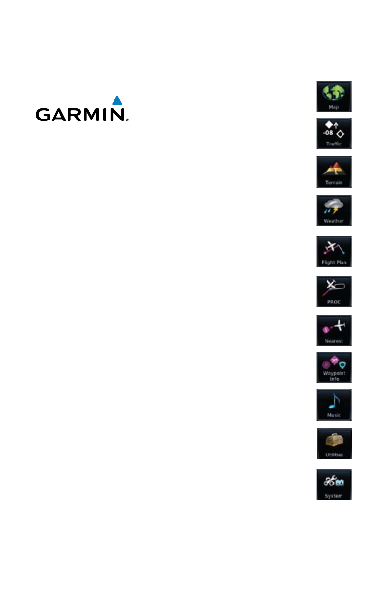
Map
Traffic
Terrain
GTN 625/635/650
Pilot's Guide
Flight Plan
Procedures
Waypoint Info
Weather
Nearest
Music
Utilities
System

© 2011 Garmin Ltd. or its subsidiaries. All rights reserved.
This manual reflects the operation of System Software version 2.00, or later. Some differences in operation
may be observed when comparing the information in this manual to later software versions.
Garmin International, Inc., 1200 East 151st Street, Olathe, KS 66062, U.S.A.
Tel: 913/397.8200 Fax: 913/397.8282
Garmin AT, Inc., 2345 Turner Road SE, Salem, OR 97302, U.S.A.
Tel: 503/391.3411 Fax 503/364.2138
Garmin (Europe) Ltd., Liberty House, Bulls Copse Road, Hounsdown Business Park, Southampton,
SO40 9RB, U.K.
Tel. +44 (0) 870 850 1243 Fax +44 (0) 238 052 4004
Garmin Corporation, No. 68, Jangshu 2nd Road, Shijr, Taipei County, Taiwan
Tel: 886/02.2642.9199 Fax: 886/02.2642.9099
Garmin Singapore Pte. Ltd., 46 East Coast Road, #05-06 Eastgate, Singapore 428766
Tel : (65) 63480378 Fax : ( 65 ) 63480278
At Garmin, we value your opinion. For comments about this guide, please e-mail:
Techpubs.Salem@Garmin.com
www.garmin.com
Except as expressly provided herein, no part of this manual may be reproduced, copied, transmitted,
disseminated, downloaded or stored in any storage medium, for any purpose without the express written
permission of Garmin. Garmin hereby grants permission to download a single copy of this manual and of
any revision to this manual onto a hard drive or other electronic storage medium to be viewed for personal
use, provided that such electronic or printed copy of this manual or revision must contain the complete text
of this copyright notice and provided further that any unauthorized commercial distribution of this manual
or any revision hereto is strictly prohibited.
Garmin® and SafeTaxi® are registered trademarks of Garmin Ltd. or its subsidiaries. Garmin SVT™ is
a trademark of Garmin Ltd. or its subsidiaries. These trademarks may not be used without the express
permission of Garmin.
NavData® is a registered trademark of Jeppesen, Inc.; StormScope® and SkyWatch® are registered
trademarks of L-3 Communications; and XM® is a registered trademark of XM Satellite Radio, Inc.;
Iridium® is a registered trademark of Iridium Communications Inc.; Canadian radar data provided by
Environment Canada; United States radar data provided by NOAA; European radar data collected and
provided by Meteo France.
March 2011 Printed in the U.S.A.

LIMITED WARRANTY
All Garmin avionics products are warranted to be free from defects in materials or workmanship for:
two years from the date of purchase for new Remote-Mount and Panel-Mount products; one year
from the date of purchase for new portable products and any purchased newly-overhauled products;
six months for newly-overhauled products exchanged through a Garmin Authorized Service Center;
and 90 days for factory repaired or newly-overhauled products exchanged at Garmin in lieu of repair.
Within the applicable period, Garmin will, at its sole option, repair or replace any components that
fail in normal use. Such repairs or replacement will be made at no charge to the customer for parts
or labor, provided that the customer shall be responsible for any transportation cost. This warranty
does not apply to: (i) cosmetic damage, such as scratches, nicks and dents; (ii) consumable parts,
such as batteries, unless product damage has occurred due to a defect in materials or workmanship;
(iii) damage caused by accident, abuse, misuse, water, flood, fire, or other acts of nature or external
causes; (iv) damage caused by service performed by anyone who is not an authorized service
provider of Garmin; or (v) damage to a product that has been modified or altered without the written
permission of Garmin. In addition, Garmin reserves the right to refuse warranty claims against
products or services that are obtained and/or used in contravention of the laws of any country.
THE WARRANTIES AND REMEDIES CONTAINED HEREIN ARE EXCLUSIVE AND IN LIEU OF ALL OTHER
WARRANTIES, WHETHER EXPRESS, IMPLIED OR STATUTORY, INCLUDING ANY LIABILITY ARISING
UNDER ANY WARRANTY OF MERCHANTABILITY OR FITNESS FOR A PARTICULAR PURPOSE,
STATUTORY OR OTHERWISE. THIS WARRANTY GIVES YOU SPECIFIC LEGAL RIGHTS, WHICH MAY
VARY FROM STATE TO STATE.
IN NO EVENT SHALL GARMIN BE LIABLE FOR ANY INCIDENTAL, SPECIAL, INDIRECT OR CONSEQUENTIAL
DAMAGES, WHETHER RESULTING FROM THE USE, MISUSE OR INABILITY TO USE THE PRODUCT OR
FROM DEFECTS IN THE PRODUCT. SOME STATES DO NOT ALLOW THE EXCLUSION OF INCIDENTAL OR
CONSEQUENTIAL DAMAGES, SO THE ABOVE LIMITATIONS MAY NOT APPLY TO YOU.
Garmin retains the exclusive right to repair or replace (with a new or newly-overhauled replacement
product) the product or software or offer a full refund of the purchase price at its sole discretion.
SUCH REMEDY SHALL BE YOUR SOLE AND EXCLUSIVE REMEDY FOR ANY BREACH OF WARRANTY.
Online Auction Purchases: Products purchased through online auctions are not eligible for
warranty coverage. Online auction confirmations are not accepted for warranty verification. To obtain
warranty service, an original or copy of the sales receipt from the original retailer is required. Garmin
will not replace missing components from any package purchased through an online auction.
International Purchases: A separate warranty may be provided by international distributors for
devices purchased outside the United States depending on the country. If applicable, this warranty is
provided by the local in-country distributor and this distributor provides local service for your device.
Distributor warranties are only valid in the area of intended distribution. Devices purchased in the
United States or Canada must be returned to the Garmin service center in the United Kingdom, the
United States, Canada, or Taiwan for service.
Foreward
Getting
Started
Xpdr Ctrl
Com/Nav
FPL
Direct-To
Proc
Wpt Info
Map
Traffic
Terrain
Weather
Nearest
Music
Utilities
System
Messages
Symbols
To obtain warranty service, contact your local Garmin Authorized Service Center. For assistance in
locating a Service Center near you, visit the Garmin web site at http://www.garmin.com or contact
Garmin Customer Service at 800-800-1020.
Garmin GTN 625/635/650 Pilot’s Guide
Appendix
Index
i190-01004-03 Rev. B

Foreward
Getting
Started
Xpdr Ctrl
Com/Nav
FPL
Direct-To
Proc
WARNING: Navigation and terrain separation must NOT be predicated
upon the use of the terrain function. The GTN 6XX Terrain Proximity feature
is NOT intended to be used as a primary reference for terrain avoidance
and does not relieve the pilot from the responsibility of being aware of
surroundings during flight. The Terrain Proximity feature is only to be used
as an aid for terrain avoidance and is not certified for use in applications
requiring a certified terrain awareness system. Terrain data is obtained
from third party sources. Garmin is not able to independently verify the
accuracy of the terrain data.
WARNING: The displayed minimum safe altitudes (MSAs) are only advisory
in nature and should not be relied upon as the sole source of obstacle and
terrain avoidance information. Always refer to current aeronautical charts
for appropriate minimum clearance altitudes.
Wpt Info
Map
Traffic
Terrain
Weather
Nearest
Music
Utilities
System
Messages
Symbols
Appendix
WARNING: The Garmin GTN 6XX has a very high degree of functional
integrity. However, the pilot must recognize that providing monitoring and/
or self-test capability for all conceivable system failures is not practical.
Although unlikely, it may be possible for erroneous operation to occur
without a fault indication shown by the GTN 6XX. It is thus the responsibility
of the pilot to detect such an occurrence by means of cross-checking with
all redundant or correlated information available in the cockpit.
WARNING: The altitude calculated by GPS receivers is geometric height
above Mean Sea Level and could vary significantly from the altitude
displayed by pressure altimeters, such as the output from the GDC 74A/B
Air Data Computer, or other altimeters in aircraft. GPS altitude should never
be used for vertical navigation. Always use pressure altitude displayed by
pressure altimeters in the aircraft.
WARNING: Do not use outdated database information. Databases used
in the GTN 6XX system must be updated regularly in order to ensure that
the information remains current. Pilots using an outdated database do so
entirely at their own risk.
WARNING: Do not use basemap (land and water data) information for
primary navigation. Basemap data is intended only to supplement other
approved navigation data sources and should be considered as an aid to
enhance situational awareness.
Index
ii
Garmin GTN 625/635/650 Pilot’s Guide
190-01004-03 Rev. B
WARNING: Traffic information shown on the GTN 6XX is provided as an
aid in visually acquiring traffic. Pilots must maneuver the aircraft based only
upon ATC guidance or positive visual acquisition of conflicting traffic.
WARNING: Datalink weather should not be used for hazardous weather
penetration. Weather information provided by the GDL 69/69A is approved
only for weather avoidance, not penetration.
WARNING: Datalink weather data is to be used for long-range planning
purposes only. Due to inherent delays in data transmission and the relative
age of the data, datalink weather data should not be used for short-range
weather avoidance.
Foreward
Getting
Started
Xpdr Ctrl
Com/Nav
FPL
Direct-To
WARNING: For safety reasons, GTN 6XX operational procedures must be
learned on the ground.
WARNING: To reduce the risk of unsafe operation, carefully review and
understand all aspects of the GTN 6XX Pilot’s Guide. Thoroughly practice
basic operation prior to actual use. During flight operations, carefully
compare indications from the GTN 6XX to all available navigation sources,
including the information from other NAVAIDs, visual sightings, charts, etc.
For safety purposes, always resolve any discrepancies before continuing
navigation.
WARNING: Never use the datalink weather to attempt to penetrate a
thunderstorm. Both the FAA Advisory Circular, Subject: Thunderstorms, and
the Airman’s Information Manual (AIM) recommend avoiding “by at least
20 miles any thunderstorm identified as severe or giving an intense radar
echo.”
CAUTION: The United States government operates the Global Positioning
System and is solely responsible for its accuracy and maintenance. The
GPS system is subject to changes which could affect the accuracy and
performance of all GPS equipment. Portions of the Garmin GTN 6XX utilize
GPS as a precision electronic NAVigation AID (NAVAID). Therefore, as with
all NAVAIDs, information presented by the GTN 6XX can be misused or
misinterpreted and, therefore, become unsafe.
Proc
Wpt Info
Map
Traffic
Terrain
Weather
Nearest
Music
Utilities
System
Messages
Symbols
Garmin GTN 625/635/650 Pilot’s Guide
Appendix
Index
iii190-01004-03 Rev. B
Foreward
Getting
Started
CAUTION: The Garmin GTN 6XX does not contain any user-serviceable
parts. Repairs should only be made by an authorized Garmin service center.
Unauthorized repairs or modifications could void both the warranty and
the pilot’s authority to operate this device under FAA/FCC regulations.
Xpdr Ctrl
Com/Nav
FPL
Direct-To
Proc
Wpt Info
Map
Traffic
Terrain
Weather
Nearest
Music
CAUTION: The GTN displays use a lens coated with a special anti-reflective
coating that is very sensitive to skin oils, waxes, and abrasive cleaners.
CLEANERS CONTAINING AMMONIA WILL HARM THE ANTI-REFLECTIVE
COATING. It is very important to clean the lens using a clean, lint-free cloth
and an eyeglass lens cleaner that is specified as safe for anti-reflective
coatings.
CAUTION: Garmin would like to remind pilots flying with GDL
69/69A-equipped aircraft that TFRs are only advisory and are not a
replacement for a thorough preflight briefing on TFR times and locations.
Always confirm TFR data through official sources and contact your Flight
Service Station for interpretation of TFR data.
NOTE: All visual depictions contained within this document, including
screen images of the GTN bezel and displays, are subject to change and
may not reflect the most current GTN software. Depictions of equipment
may differ slightly from the actual equipment.
NOTE: This device complies with part 15 of the FCC Rules. Operation is
subject to the following two conditions: (1) this device may not cause
harmful interference, and (2) this device must accept any interference
received, including interference that may cause undesired operation.
NOTE: Terrain data is not displayed when the aircraft latitude is greater
than 75° North or 60° South.
Utilities
System
Messages
Symbols
Appendix
Index
NOTE: This product, its packaging, and its components contain chemicals
known to the State of California to cause cancer, birth defects, or
reproductive harm. This notice is being provided in accordance with
California’s Proposition 65. If you have any questions or would like
additional information, please refer to our web site at www.garmin.com/
prop65.
NOTE: Canadian installations: In accordance with Canadian Radio
Specifications Standard 102 (RSS 102), RF field strength exposure to persons
from an antenna connected to this device should be limited to 60V/m for
controlled environment and 28 V/m for uncontrolled environment.
iv
Garmin GTN 625/635/650 Pilot’s Guide
190-01004-03 Rev. B

NOTE: This device complies with Part 15 of
the FCC limits for Class B digital devices. This
equipment generates, uses, and can radiate
radio frequency energy and, if not installed
Help us better support you by completing our
and used in accordance with the instructions,
may cause harmful interference to radio
communications. Furthermore, there is no
guarantee that interference will not occur in a
or stolen unit tracking. Please, have the serial
particular installation.
web site (www.garmin.com) and look for our
If this equipment does cause harmful
interference, the user is encouraged to try
to correct the interference by relocating the
equipment or connecting the equipment to a
different circuit than the affected equipment.
Consult an authorized dealer or other qualified
avionics technician for additional help if these
remedies do not correct the problem.
anti-reflective coating which is very sensitive to
skin oils, waxes and abrasive cleaners. It is very
important to clean the lens using an eyeglass
lens cleaner which is specified as safe for anti-
reflective coatings and a clean, lint-free cloth.
Operation of this device is subject to the
following conditions: (1) This device may
not cause harmful interference, and (2) this
device must accept any interference received,
including interference that may cause undesired
performance and functional requirements of AC
operation.
To obtain accessories for your unit, please
contact your Garmin dealer.
on-line registration form today! Registration
ensures that you will be notified of product
updates and new products and provides lost
number of your unit handy, connect to our
Product Registration link on the Home page.
The display surface is coated with a special
AC 90-100A Statement of Compliance:
The Garmin navigational unit meets the
90-100A.
Foreward
Getting
Started
Xpdr Ctrl
Com/Nav
FPL
Direct-To
Proc
Wpt Info
Map
Traffic
Terrain
Weather
Product Registration and Support
Help us better support you by completing your online registration today!
Have the serial number of your product handy and connect to the Garmin web
site (www.garmin.com). Look for the Product Registration link on the Home
page. Also, be sure to record your serial number in the space provided.
If you have any questions, the Garmin Product Support department may be
reached Monday through Friday, 7:00 AM to 7:00 PM Central Time.
US: 913-397-8200
US Toll Free: 1-866-739-5687
Canada Toll Free: 1-866-429-9296
Garmin GTN 625/635/650 Pilot’s Guide
v190-01004-03 Rev. B
Nearest
Music
Utilities
System
Messages
Symbols
Appendix
Index

Foreward
Getting
Started
Xpdr Ctrl
Com/Nav
FPL
Direct-To
Proc
Wpt Info
Map
Traffic
Terrain
Record of Revisions
Part Number Revision Date Description
190-01007-03 A
2/4/11 Initial release
B
Weather
Nearest
Music
Utilities
System
Messages
Symbols
Appendix
Index
vi
Garmin GTN 625/635/650 Pilot’s Guide
190-01004-03 Rev. B

Contents
Product Registration and Support ......................................................................v
Welcome ... .................................................................................................... xvi
About This Guide ............................................................................................ xvi
Conventions .................................................................................................. xvii
1 Getting Started ....................................................................................1-1
1.1 Model Descriptions .............................................................................. 1-1
1.1.1 GTN 625 ...............................................................................1-1
1.1.2 GTN 635 ...............................................................................1-2
1.1.3 GTN 650 ...............................................................................1-2
1.2 About This Pilot's Guide .......................................................................1-2
1.2.1 Conventions ..........................................................................1-2
1.2.2 Using the Touchscreen ........................................................... 1-2
1.3 Product Description ..............................................................................1-3
1.3.1 Secure Data Card ..................................................................1-3
1.3.2 Pilot Controls ........................................................................ 1-4
1.3.2.1 Volume/Squelch Knob ............................................................1-4
1.3.2.2 Large/Small Concentric Knobs ................................................1-4
1.3.2.3 HOME Key ............................................................................. 1-4
1.3.2.4 Direct-To Key ......................................................................... 1-5
1.3.2.5 Touchscreen Keys .................................................................. 1-5
1.4 Unit Power Up .....................................................................................1-6
1.4.1 Start-Up Screens ....................................................................1-6
1.4.2 Database Verification and Fuel Settings ..................................1-7
1.5 System Operation...............................................................................1-10
1.5.1 Using the Touchscreen Key Controls ..................................... 1-10
1.5.2 Setup Page ..........................................................................1-10
1.5.2.1 System Setup Values ............................................................1-11
1.5.2.2 Units Settings Values ...........................................................1-12
1.5.2.3 Alerts Settings Values ..........................................................1-13
1.5.3 Dual GTN 6XX Installations .................................................1-13
1.6 Direct-To Navigation .......................................................................... 1-15
1.6.1 Direct-To a Waypoint ...........................................................1-15
1.6.2 Direct-To a Flight Plan Waypoint .......................................... 1-15
1.6.3 Direct-To a Nearest Airport ..................................................1-15
Foreward
Getting
Started
Xpdr Ctrl
Com/Nav
FPL
Direct-To
Proc
Wpt Info
Map
Traffic
Terrain
Weather
Nearest
Music
Utilities
System
Messages
Symbols
Appendix
Index
Garmin GTN 625/635/650 Pilot’s Guide
vii190-01004-03 Rev. B

Foreward
Getting
Started
Xpdr Ctrl
Com/Nav
FPL
Direct-To
Proc
Wpt Info
Map
Traffic
Terrain
Weather
Nearest
Music
Utilities
System
Messages
Symbols
Appendix
Index
1.7 Selecting Com Frequencies .................................................................1-16
1.8 Flight Planning ..................................................................................1-18
1.8.1 Creating a Flight Plan ..........................................................1-18
1.9 IFR Procedures ................................................................................... 1-19
1.10 Dead Reckoning .................................................................................1-20
2 Transponder Controls (Optional).........................................................2-1
2.1 Select Transponder ...............................................................................2-2
2.2 IDENT .................................................................................................. 2-2
2.3 Transponder Mode ............................................................................... 2-3
2.3.1 Standby .................................................................................2-3
2.3.2 Ground .................................................................................2-4
2.3.3 On ........................................................................................ 2-4
2.3.4 Altitude Reporting .................................................................2-5
2.4 VFR ..................................................................................................... 2-5
2.5 Selecting a Squawk Code ..................................................................... 2-6
3 NAV/COM .............................................................................................3-1
3.1 Volume ................................................................................................3-2
3.2 Squelch ...............................................................................................3-2
3.3 Com and Nav Frequency Window and Tuning ....................................... 3-3
3.3.1 Com and Nav Frequency Finding ............................................3-5
3.3.1.1 Find Recent Frequencies ........................................................3-5
3.3.1.2 Find Nearest Frequencies .......................................................3-6
3.3.1.3 Find Flight Plan Frequencies ...................................................3-7
3.3.1.4 Find User Frequencies ............................................................ 3-8
3.3.2 Adding a New User Frequency ...............................................3-8
3.3.3 Emergency Frequency .......................................................... 3-10
3.3.4 Stuck Microphone ...............................................................3-10
3.3.5 Remote Frequency Selection Control .................................... 3-11
3.4 Com Frequency Monitoring ................................................................ 3-11
3.5 Nav (VOR/Localizer/Glideslope) Receiver Operations ........................... 3-12
3.5.1 Ident Audio and Volume ......................................................3-12
3.5.2 Nav Tuning Window .............................................................3-13
3.5.3 Nav Frequency Finding ........................................................3-14
4 Flight Plans .......................................................................................4-1
4.1 Creating a New Flight Plan ..................................................................4-2
4.2 Active Flight Plan Page.........................................................................4-4
4.2.1 Waypoint Options .................................................................. 4-5
viii
Garmin GTN 625/635/650 Pilot’s Guide
190-01004-03 Rev. B

4.2.1.1 Activate Leg ..........................................................................4-6
4.2.1.2 Insert Before .........................................................................4-7
4.2.1.3 Insert After ............................................................................ 4-8
4.2.1.4 Remove ................................................................................. 4-8
4.2.1.5 Load Procedures .................................................................... 4-9
4.2.1.6 Waypoint Info........................................................................4-9
4.2.2 Airways ............................................................................... 4-10
4.3 Flight Plan Menu ...............................................................................4-13
4.3.1 Store Flight Plan ..................................................................4-14
4.3.2 Invert Flight Plan ................................................................. 4-14
4.3.3 Parallel Track .......................................................................4-15
4.3.4 Edit Data Fields ................................................................... 4-17
4.3.5 Flight Plan Catalog Route Options ....................................... 4-18
4.3.5.1 Catalog Route Option - Activate........................................... 4-19
4.3.5.2 Catalog Route Option - Invert & Activate .............................. 4-19
4.3.5.3 Catalog Route Option - Preview ........................................... 4-20
4.3.5.4 Catalog Route Option - Edit ................................................. 4-20
4.3.5.5 Catalog Route Option - Copy ............................................... 4-21
4.3.5.6 Catalog Route Option - Delete ............................................. 4-22
4.3.6 Delete Flight Plan ................................................................ 4-22
4.3.6.1 Delete Flight Plan from Catalog ........................................... 4-22
4.3.6.2 Delete Active Flight Plan ...................................................... 4-23
4.3.8 Preview Flight Plan ..............................................................4-24
4.3.8.1 Previewing the Active Flight Plan .........................................4-24
4.3.8.2 Previewing a Flight Plan in the Catalog ................................ 4-24
5 Direct-To ...............................................................................................5-1
5.1 Direct-To Navigation ............................................................................ 5-1
5.2 Direct-To a Flight Plan Waypoint ........................................................... 5-3
5.3 Direct-To a Nearest Airport ...................................................................5-4
5.4 Removing a Direct-To Course ............................................................... 5-5
5.5 Direct-To Map Waypoint ....................................................................... 5-6
5.6 Off-Route Direct-To Course .................................................................. 5-7
6 Procedures ........................................................................................6-1
6.1 Basic Approach Operations ..................................................................6-1
6.2 Selecting a Departure ........................................................................... 6-3
6.3 Selecting an Arrival .............................................................................. 6-5
6.4 Selecting an Approach ......................................................................... 6-7
Foreward
Getting
Started
Xpdr Ctrl
Com/Nav
FPL
Direct-To
Proc
Wpt Info
Map
Traffic
Terrain
Weather
Nearest
Music
Utilities
System
Messages
Symbols
Appendix
Index
Garmin GTN 625/635/650 Pilot’s Guide
ix190-01004-03 Rev. B

Foreward
Getting
Started
Xpdr Ctrl
Com/Nav
FPL
Direct-To
Proc
Wpt Info
Map
Traffic
Terrain
Weather
Nearest
Music
Utilities
System
Messages
Symbols
Appendix
Index
6.5 Approaches with Procedure Turns ....................................................... 6-10
6.6 Flying the Missed Approach ............................................................... 6-10
6.7 Flying an Approach with a Hold ..........................................................6-11
6.8 Flying a DME Arc Approach ................................................................ 6-12
6.11 ILS Approaches (GTN 650 Only) .........................................................6-13
6.12 RNAV Approach Procedures ...............................................................6-14
6.13 Points to Remember for All Procedures ...............................................6-15
6.14 Points to Remember for Localizer or VOR-based Approaches ...............6-15
6.15 Enabling Autopilot Outputs for the King KAP140/KFC225 ................... 6-17
7 Waypoint Info ...................................................................................7-1
7.1 Waypoint Selection .............................................................................. 7-3
7.2 Airport .............................................................................................. 7-4
7.2.1 Info ....................................................................................... 7-4
7.2.2 Preview ................................................................................. 7-5
7.2.3 Procedures ............................................................................ 7-6
7.2.4 Runways ............................................................................... 7-7
7.2.5 Frequencies ........................................................................... 7-8
7.2.6 Weather (WX) Data ............................................................... 7-9
7.3 Intersection (INT) ............................................................................... 7-10
7.4 VOR ..................................................................................................7-11
7.5 NDB .................................................................................................. 7-12
7.6 User Waypoints (User) ........................................................................ 7-13
7.6.1 Select User Waypoint By Name ............................................ 7-14
7.6.2 Select User Waypoint From A List ......................................... 7-14
7.6.3 Edit User Waypoint ..............................................................7-14
7.6.4 Delete User Waypoint ..........................................................7-14
7.7 Create Waypoint .................................................................. 7-15
7.7.1 Waypoint Location Based on Lat/Lon Coordinates ................ 7-16
7.7.2
7.7.3
Waypoint Location Based on Two Radials ........................................7-17
Waypoint Location Based on Radial and Distance ............................7-18
8 Map ...................................................................................................8-1
8.1 Map Menu ..........................................................................................8-3
8.1.1 Map Overlays ........................................................................ 8-4
8.1.1.1 Topo ..................................................................................... 8-4
8.1.1.2 Airways ................................................................................. 8-4
8.1.1.3 Terrain .................................................................................. 8-5
8.1.1.4 NEXRAD (Optional) ............................................................... 8-5
x
Garmin GTN 625/635/650 Pilot’s Guide
190-01004-03 Rev. B

8.1.1.5 StormScope® (Optional) ......................................................... 8-6
7.1.1.6 Traffic (Optional) .................................................................... 8-6
8.1.2 Map Setup ............................................................................8-7
8.1.2.1 Map ...................................................................................... 8-9
7.1.2.2 Aviation .............................................................................. 8-15
8.1.2.3 Land ................................................................................... 8-16
8.1.2.4 Airway Range ...................................................................... 8-17
8.1.2.5 Traffic (Optional) .................................................................. 8-18
8.1.2.6 Weather (Optional) .............................................................. 8-19
8.1.3 Map Data Fields .................................................................. 8-19
8.1.4 Map Detail .......................................................................... 8-21
8.2 Map Panning ..................................................................................... 8-23
8.3 Map Controls ..................................................................................... 8-25
8.3.1 Pan Map Mode....................................................................8-25
8.3.2 Create Waypoint .................................................................. 8-25
8.3.3 Graphically Edit Flight Plan Mode ........................................8-26
8.3.3.1 Adding a Waypoint to an Existing Flight Plan .......................8-26
8.3.3.2 Adding a Waypoint to the End of an Existing Flight Plan ....... 8-27
8.3.3.3 Removing a Waypoint from an Existing Flight Plan ...............8-28
8.3.3.4 Creating a Flight Plan Without an Existing Flight Plan ........... 8-28
8.4 CDI (GTN 650 only) ........................................................................8-29
8.5 OBS ................................................................................................ 8-30
8.6 Map Symbols ..................................................................................... 8-31
®
8.7 SafeTaxi
8.7.1 Using SafeTaxi
.........................................................................................8-32
®
.................................................................8-32
8.7.2 Hot Spot Information ........................................................... 8-33
®
8.7.3 SafeTaxi
Cycle Number and Revision .................................. 8-33
9 Traffic ................................................................................................9-1
9.1 Traffic Information Service (TIS) (Optional) ............................................ 9-1
9.1.1 TIS Symbology .......................................................................9-2
9.1.2 Traffic Map Page....................................................................9-3
9.1.3 Displaying Traffic on the Traffic Page ....................................... 9-4
9.1.4 Altitude Display .....................................................................9-4
9.1.5 TIS Limitations ....................................................................... 9-5
9.1.6 TIS Alerts ............................................................................... 9-7
9.1.7 TIS System Status .................................................................. 9-8
9.2 TAS Traffic (Optional)..........................................................................9-10
Foreward
Getting
Started
Xpdr Ctrl
Com/Nav
FPL
Direct-To
Proc
Wpt Info
Map
Traffic
Terrain
Weather
Nearest
Music
Utilities
System
Messages
Symbols
Appendix
Index
Garmin GTN 625/635/650 Pilot’s Guide
xi190-01004-03 Rev. B

Foreward
Getting
Started
Xpdr Ctrl
Com/Nav
FPL
Direct-To
Proc
Wpt Info
Map
Traffic
Terrain
Weather
Nearest
Music
Utilities
System
Messages
Symbols
Appendix
Index
9.2.1 TAS Symbology .................................................................... 9-11
9.2.1 Displaying and Operating Traffic (TAS Systems) .....................9-12
9.2.1.1 Switching from Standby Mode to Operating Mode ............... 9-12
9.2.1.2 Range Ring ......................................................................... 9-13
9.2.2 Altitude Display ...................................................................9-13
9.2.4 Traffic System Status ............................................................ 9-14
9.2.5 Traffic Pop-Up......................................................................9-15
9.3 Traffic Test ......................................................................................... 9-16
10 Terrain .............................................................................................10-1
10.1 Terrain Configurations ........................................................................10-1
10.2 Terrain Proximity ................................................................................ 10-1
10.2.1 Displaying Terrain Proxmity .................................................. 10-3
10.2.1.1 Terrain Page 120° Arc or 360° Rings .................................... 10-4
10.2.2 Terrain Limitations ............................................................... 10-5
10.3 Terrain Awareness and Warning System (TAWS-B) Optional ................. 10-6
10.3.1 TAWS-B Requirements .........................................................10-6
10.3.2 TAWS-B Limitations ............................................................. 10-6
10.3.3 Computing GPS Altitude for TAWS ....................................... 10-7
10.3.4 Baro-Corrected Altitude Versus GSL Altitude .........................10-7
10.3.5 Using TAWS ........................................................................10-8
10.3.6 Displaying TAWS Data ......................................................... 10-9
10.3.7 TAWS Page .......................................................................10-10
10.3.7.1 Terrain Page Layers ............................................................ 10-10
10.3.7.2 Terrain Page View .............................................................. 10-11
10.3.7.3 Terrain Page TAWS Selections ............................................10-11
10.3.8 TAWS Alerts ......................................................................10-12
10.3.8.1 TAWS-B Alerting Colors and Symbology ............................. 10-13
10.3.8.2 Excessive Descent Rate Alert .............................................. 10-15
10.3.8.3 Forward Looking Terrain Avoidance .................................... 10-15
10.3.8.4 Premature Descent Alerting ............................................... 10-16
10.3.8.5 Negative Climb Rate After Take-Off Alert (NCR) .................. 10-17
10.3.8.8 TAWS Not Available Alert ................................................... 10-18
10.3.8.9 TAWS Failure Alert ............................................................. 10-18
10.3.9 TAWS System Status .......................................................... 10-18
11 Weather ..........................................................................................11-1
11.1 XM Weather Products (Optional) ........................................................ 11-1
11.1.1 Displaying Data Link Weather ..............................................11-3
xii
Garmin GTN 625/635/650 Pilot’s Guide
190-01004-03 Rev. B

11.1.2 Weather Legend ..................................................................11-4
11.1.3 Weather Map Orientation ....................................................11-5
11.1.4 XM Weather Symbols and Product Age ................................ 11-6
11.1.5 NEXRAD ............................................................................. 11-8
11.1.5.1 Reflectivity ..........................................................................11-9
11.1.5.2 NEXRAD Limitations ..........................................................11-10
11.1.6 Echo Tops .......................................................................... 11-12
11.1.7 Cloud Tops ........................................................................ 11-13
11.1.8 Cell Movement .................................................................. 11-14
11.1.9 SIGMETs and AIRMETs ......................................................11-15
11.1.10 County Warnings ............................................................... 11-16
11.1.11 Freezing Level.................................................................... 11-17
11.1.12 METARs ............................................................................11-18
11.1.13 Cyclone ............................................................................. 11-19
11.1.14 Lightning ........................................................................... 11-20
11.1.15 Weather Forecast ..............................................................11-21
11.1.16 Winds Aloft ....................................................................... 11-23
11.1.17 Icing ................................................................................. 11-24
11.1.18 Turbulence ........................................................................ 11-25
11.1.19 AIREP/PIREP ......................................................................11-26
®
11.2 StormScope
11.2.1 StormScope
11.2.2 Clearing the StormScope
11.2.3 Changing the StormScope
11.2.4 Changing the StormScope
11.2.5 Displaying StormScope
Weather ................................................................... 11-27
®
(Optional) ..................................................... 11-27
®
Page .........................................11-28
®
Display View ...........................11-28
®
Data Display Range .................11-29
®
Data on the Map Page ................. 11-29
12 Nearest ...........................................................................................12-1
12.1 Select a Nearest Page ........................................................................ 12-2
12.2 Nearest Airport ..................................................................................12-3
12.3 Nearest Intersection (INT) ..................................................................12-4
12.4 Nearest VOR ...................................................................................... 12-5
12.5 Nearest NDB ...................................................................................... 12-7
12.6 Nearest User Waypoint ....................................................................... 12-8
12.7 Nearest Airspace ................................................................................ 12-9
12.8 Nearest ARTCC ................................................................................12-11
12.9 Nearest Flight Service Station (FSS) ..................................................12-12
12.10 Nearest Weather Frequency (WX Freq) .............................................. 12-13
Foreward
Getting
Started
Xpdr Ctrl
Com/Nav
FPL
Direct-To
Proc
Wpt Info
Map
Traffic
Terrain
Weather
Nearest
Music
Utilities
System
Messages
Symbols
Appendix
Index
Garmin GTN 625/635/650 Pilot’s Guide
xiii190-01004-03 Rev. B

Foreward
Getting
Started
Xpdr Ctrl
Com/Nav
FPL
Direct-To
Proc
Wpt Info
Map
Traffic
Terrain
Weather
Nearest
Music
Utilities
System
Messages
Symbols
Appendix
Index
13 Music ...............................................................................................13-1
13.1 Activating XM® Satellite Radio Services .............................................. 13-2
13.2 Music Operation ................................................................................ 13-3
13.2.1 Browsing Channels and Categories ...................................... 13-4
®
13.2.2 Selecting an XM
®
13.2.3 XM
13.2.4 XM
Radio Volume ..............................................................13-6
®
Radio Channel Presets ................................................. 13-7
Radio Channel by Number .......................13-5
13.2.4.1 Saving a Preset .................................................................... 13-7
13.2.4.2 Recalling a Preset ................................................................13-7
13.3 GDL 69/69A Data Link Receiver Troubleshooting .................. 13-8
14 Utilities ...........................................................................................14-1
14.1 Vertical Calculator (VCALC) ............................................................. 14-3
14.1.1 Target Altitude ..................................................................... 14-5
14.1.2 Altitude Type ....................................................................... 14-5
14.1.3 Vertical Speed (VS) Profile .................................................... 14-6
14.1.4 Target Offset .......................................................................14-6
14.1.5 Before/After Target Waypoint ............................................... 14-7
14.1.6 Target Waypoint .................................................................. 14-7
14.1.7 Display VCALC Messages ..................................................... 14-8
14.1.8 Restore VCALC Defaults ....................................................... 14-8
14.2 Flight Timers ...................................................................................14-9
14.3 RAIM Prediction ............................................................................... 14-10
14.4 Trip Planning ...................................................................................14-12
14.4.1 Point-To-Point Mode .......................................................... 14-13
14.3.2 Flight Plan Mode ............................................................... 14-16
14.5 Fuel Planning ................................................................................... 14-18
14.5.1 Point-To-Point Mode .......................................................... 14-18
14.5.2 Flight Plan Mode ............................................................... 14-21
14.6 DALT/TAS/Winds .............................................................................. 14-23
14.7 Clean Screen Mode .......................................................................... 14-26
15 System ...........................................................................................15-1
15.1.1 Serial Number and System ID ............................................... 15-4
15.1.2 Version Information ............................................................. 15-4
15.1.3 Database Information .......................................................... 15-4
15.2 GPS Status ......................................................................................... 15-7
15.2.1 GPS Status Page .................................................................. 15-7
15.2.2 Satellite-Based Augmentation System (SBAS) .....................15-10
xiv
Garmin GTN 625/635/650 Pilot’s Guide
190-01004-03 Rev. B

15.2.3 Circle of Uncertainty .......................................................... 15-11
15.3 External LRUs ..................................................................................15-11
15.3.1 GDL 69 (and GDL 69A) Status ........................................... 15-12
15.4 Setup...............................................................................................15-14
15.4.1 System Setup.....................................................................15-14
15.4.2 CDI Selection ..................................................................... 15-15
15.4.3 Date/Time ......................................................................... 15-16
15.4.4 Nearest Airport Criteria ...................................................... 15-17
15.4.5 Com Channel Spacing ....................................................... 15-18
15.4.6 Crossfill ............................................................................. 15-19
15.4.2 Alerts Settings ................................................................... 15-21
15.4.2.1 Arrival ............................................................................... 15-21
15.4.2.2 Proximity ........................................................................... 15-21
15.4.2.3 Airspace Alert Options ....................................................... 15-22
15.5 Units Settings ..................................................................................15-23
15.5.1 Setup Units ....................................................................... 15-23
15.5.2 Setting a User-Configured (Manual) Nav Angle ..................15-24
15.6 Audio .............................................................................................. 15-26
15.7 Ownship Settings ............................................................................. 15-26
15.8 Backlight Settings ............................................................................ 15-27
16 Alert Messages ...............................................................................16-1
Foreward
Getting
Started
Xpdr Ctrl
Com/Nav
FPL
Direct-To
Proc
Wpt Info
Map
Traffic
Terrain
17 Symbols ..............................................................................................17-1
17.1 Map Page Symbols.............................................................................17-1
17.2 SafeTaxi
™ Symbols .......................................................................... 17-2
17.3 Traffic Symbols ................................................................................... 17-2
17.4 Terrain Obstacle Symbols ...................................................................17-3
17.5 Basemap Symbols ..............................................................................17-4
17.6 Map Tool Bar Symbols ........................................................................ 17-4
17.7 Miscellaneous Symbols ......................................................................17-5
18 Appendix ............................................................................................18-1
18.1 Glossary ............................................................................................18-1
18.2 SD Card Use and Databases ............................................................... 18-9
18.2.1 Jeppesen Databases ............................................................ 18-9
18.2.2 Garmin Databases ............................................................. 18-10
18.3 Demo Mode ....................................................................................18-13
18.4 Glove Qualification Procedure .......................................................... 18-16
Index .....................................................................................................Index-1
Garmin GTN 625/635/650 Pilot’s Guide
Weather
Nearest
Music
Utilities
System
Messages
Symbols
Appendix
Index
xv190-01004-03 Rev. B

Foreward
Getting
Started
Xpdr Ctrl
Com/Nav
FPL
Welcome ...
Welcome to the GTN era of navigation. The Garmin GTN supports airway
navigation and flexible flight planning, including arrival and departure procedures
and precision approaches. All of these advanced features are easily accessed with
an easy-to-use touchscreen display, another first for general aviation. You can
be confident in knowing that this product has been designed to meet or exceed
industry performance standards and is supported through a global network of
Garmin Aviation Distributors.
Direct-To
Proc
Wpt Info
Map
Traffic
Terrain
Weather
Nearest
Music
Utilities
System
About This Guide
Take a little time to review the various sections of this guide to familiarize
yourself with it. First, read Section 1 as an introduction to quickly get you started
with the GTN. The other sections are not meant to necessarily be read in order,
but provide detailed information on the subject they contain as you need them.
Do take the time to review the information before using the product to assist you
in getting the most out of your avionics.
Generally, a feature will be described in a section that provides a brief
description, a graphic functional diagram, and step-by-step procedures. If read
cover-to-cover sequentially, the information may seem repetitive. The guide is
designed as a reference where you will generally skip around the document
learning about a particular feature or function after becoming familiar with the
unit.
Messages
Symbols
Appendix
Index
xvi
Garmin GTN 625/635/650 Pilot’s Guide
190-01004-03 Rev. B
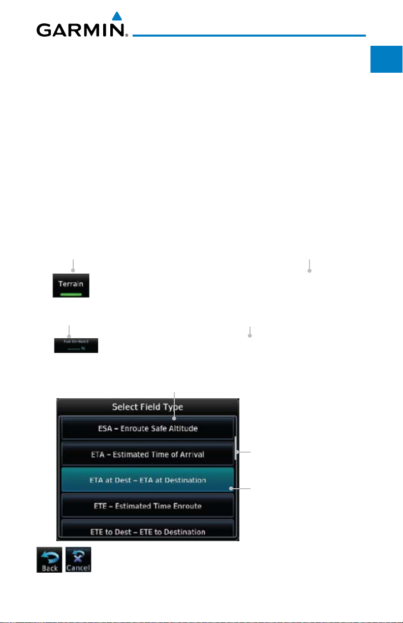
Conventions
The GTN display dynamically tailors the number and position of the controls
for each function and are engaged by merely touching them.
Touch Touch the key with your finger.
Drag Touch the list or location on the map with your finger. Continue
lightly holding your finger to the display surface and drag your
finger in the intended direction to scroll through the list or
move the location on the map.
In this pilot’s guide, keys are noted by bold text. An image of the key used
will be shown to the left of a procedure. Keys are outlined areas on the display.
Figures in the guide will identify the available controls. A key may have a name
of a control, such as Enter, Terrain, or Back. A key may also be an information
field, such as a numeric value that can be changed.
Graphic Of Key
Text Description
Of Key
Foreward
Getting
Started
Xpdr Ctrl
Com/Nav
FPL
Direct-To
Proc
Wpt Info
While viewing the Map Menu, touch the Terrain Map
Overlay key to toggle the view of Terrain data.
Graphic Of Key With
Numeric Value
When the Fuel on Board value is selected, touch the Fuel
Touching the Back key returns to the previous display. The
Cancel key cancels any information selected or entered and
returns to the previous display.
Text Description
Of Key
on Board key to display the Fuel on Board values.
List “Keys.” Touch To
Select.
Scroll Bar Indicates More
Selections Available.
Touch Finger To An Item
In The List And Drag Your
Finger To View More
Selections.
Selected Field Type
Map
Traffic
Terrain
Weather
Nearest
Music
Utilities
System
Messages
Symbols
Appendix
Index
Garmin GTN 625/635/650 Pilot’s Guide
xvii190-01004-03 Rev. B

Foreward
Getting
Started
Xpdr Ctrl
Com/Nav
FPL
Direct-To
Proc
Wpt Info
Map
Traffic
Terrain
Weather
Nearest
Music
Utilities
System
Messages
Symbols
Appendix
Index
This page intentionally left blank
xviii
Garmin GTN 625/635/650 Pilot’s Guide
190-01004-03 Rev. B

1 GETTING STARTED
Foreword
1.1 Model Descriptions
This guide covers the operation of the GTN 625, 635, and 650. In general, all
models will be referred to as the GTN 6XX, except where there are physical or
operational differences. The GTN 6XX units are approximately 6.25 inches wide
and 2.65 inches high. The display is a 600 by 266 pixel, 4.9 inch diagonal color
LCD with touchscreen controls. The units include one removable SD data card
for the databases and software upgrades.
The GTN 6XX simplifies your workload with an easy-to-use touch panel that
provides a visual display of both controls and functions. The required controls
are displayed for the selected function. Keys on the display allow you to access
and control their functions by a simple touch on the interactive display.
The GTN 6XX can integrate a variety of avionics that will not only simplify
operation, but also save panel space. The GTN 625, 635, and 650 have their
own GPS/SBAS navigator and flight planning functions. The GTN 635 adds a
VHF Com radio, while the 650 adds VHF Com and VHF Nav radios. Selected
optional external equipment allows you to display and control active traffic
systems, XM Entertainment Radio, XM Weather, audio panel, and a Mode S
transponder directly from the GTN 6XX display, and more.
1.1.1 GTN 625
Getting
Started
Xpdr Ctrl
Com/Nav
FPL
Direct-To
Proc
Wpt Info
Map
Traffic
Terrain
Weather
The GTN 625 has a GPS/SBAS engine and is TSO-C146c certified for
primary domestic, oceanic, and remote navigation including en route, terminal,
and non-precision approaches, and approaches with vertical guidance, such
as LPV and LNAV/VNAV. The GTN 625 can simultaneously give aviators vital
approach information and weather and traffic data in relation to their position
on a large, color moving map display. Thanks to a high-contrast color display,
the information can be easily read from wide viewing angles even in direct
sunlight. Its color moving map features a built-in database that shows cities,
highways, railroads, rivers, lakes, coastlines, and a complete Jeppesen database.
The Jeppesen database (that can be updated with a front-loading data card)
contains all airports, VORs, NDBs, Intersections, FSSs, Approaches, DPs/STARs,
and SUA information.
Garmin GTN 625/635/650 Pilot’s Guide
1-1190-01004-03 Rev. B
Nearest
Music
Utilities
System
Messages
Symbols
Appendix
Index
Foreword
Getting
Started
Xpdr Ctrl
Com/Nav
FPL
Direct-To
Proc
Wpt Info
Map
Traffic
Terrain
Weather
Pilots will enjoy the GTN 625 as a flexible and powerful navigator, especially
when it is coupled with traffic, lightning detection, and weather interfaces. With
the PC-based FDE prediction program, the GTN 625 may be used for oceanic
or remote operations. For the latest in graphic and text weather information,
the GTN 625 can interface to XM Satellite Radio’s XM Weather Service via the
Garmin GDL 69/69A datalink receiver.
1.1.2 GTN 635
The GTN 635 includes all of the features of the GTN 625, and also includes
a TSO’d airborne VHF communications transceiver.
1.1.3 GTN 650
The GTN 650 includes all of the features of the GTN 625, and also includes
a TSO’d airborne VHF communications transceiver and TSO’d airborne VOR/
Localizer and Glideslope receivers.
1.2 About This Pilot's Guide
1.2.1 Conventions
Bold text indicates a control. The small right knob is the smaller, inner knob
of the two concentric rotary knobs on the lower, right corner of the bezel. The
large right
knob is the larger, outer knob.
Large, Outer Knob
Small, Inner Knob
Nearest
Music
Utilities
System
Messages
Symbols
Appendix
Index
Figure 1-1 Large/Small Concentric Knobs
A graphic of a control on the side of the page refers to the control you should
use for the associated step as shown below.
1.2.2 Using the Touchscreen
Most of the controls are operated by touching the display. Highlighted icons
and keys may be simply touched to make a selection. A list of menu items may
be scrolled by touching the screen and retaining pressure while sliding your
finger up or down. Map displays may be panned by touching the screen and
retaining pressure while sliding your finger in the desired direction.
You can return to the previous page or exit the current function
by touching the Back key.
Quickly return to the Home page by pressing the HOME key.
Press and Hold the HOME key to reach the Default Nav page.
1-2
Garmin GTN 625/635/650 Pilot’s Guide
190-01004-03 Rev. B
1.3 Product Description
Foreword
This section provides an overview of the GTN 6XX product and a quick look
at some important features. The GTN 6XX presents a full-color moving map
with navigation information to the pilot through a large-format display. Controls
are a combination of rotary knobs and push-keys on the bezel with the color
display providing information as well as a touchscreen controls. The GTN 6XX
has a 600 x 266 pixel, 4.9 inch diagonal LCD display.
Volume, Squelch On/
Off, and Nav ID On/Off
SD Card
Message
Annunciation
And Key
Locking
Screw
Annunciations
Active Com/Nav
Frequency
Function
Keys
Home Page
Dual Rotary Knob
Function Hints
Figure 1-2 GTN 650 Front Panel
Standby Com/Nav
Frequency
HOME Key
Photo Sensor
Direct-To Key
Large and
Small Knobs
Xpdr Panel
Controls
1.3.1 Secure Data Card
Getting
Started
Xpdr Ctrl
Com/Nav
FPL
Direct-To
Proc
Wpt Info
Map
Traffic
Terrain
Weather
Nearest
The GTN 6XX uses a Secure Digital (SD) card to load and store various types
of data. For basic flight operations, the SD card is required for Terrain, Obstacle,
and SafeTaxi database storage as well as Jeppesen aviation database updates.
NOTE: Ensure the GTN 6XX is powered off before inserting or removing
an SD card.
NOTE: Refer to SD Card Use and Databases in the Appendix for instructions
on updating databases.
Garmin GTN 625/635/650 Pilot’s Guide
1-3190-01004-03 Rev. B
Music
Utilities
System
Messages
Symbols
Appendix
Index

Foreword
Getting
Started
Xpdr Ctrl
Com/Nav
FPL
Direct-To
Proc
Wpt Info
Map
Traffic
Terrain
Inserting an SD Card
1. Insert the SD card in the SD card slot (the label side of the card
should face the right edge of the display bezel).
2. To eject the card, gently press on the SD card to release the
spring latch.
1.3.2 Pilot Controls
The GTN 6XX controls have been designed to simplify operation of the
system and minimize workload and the time required to access sophisticated
functionality. Controls are located on the bezel and on the touchscreen display.
Controls are comprised of dual concentric knobs, volume/squelch knob, bezel
keys, and active touch areas on the display.
1.3.2.1 Volume/Squelch Knob
The Volume knob located in the top left corner of the bezel controls audio
volume for the selected Com radio or Nav receiver and other volume levels for
external audio input devices that are controlled via the GTN interface, if installed.
When the Com radio is active, press the Volume knob momentarily to disable
automatic squelch control for the Com radio. When the Nav radio is active, press
the Volume knob momentarily to enable/disable the ident tone for the Nav radio.
Weather
Nearest
Music
Utilities
System
Messages
Symbols
Appendix
Index
Figure 1-3 Volume/Squelch Knob
1.3.2.2 Large/Small Concentric Knobs
The large right and
small right
knobs are used for data entry, such as in the
Waypoint or Direct-To functions, and to set the frequencies for the communications
transceiver or the VOR/Localizer receiver in units so equipped.
Figure 1-4 Large/Small Concentric Knobs
1.3.2.3 HOME Key
Pressing the HOME key displays the Home page, the main screen for
accessing the GTN features. Pressing and holding the HOME key will open the
Default Navigation page from any other page.
Figure 1-5 HOME Key
1-4
Garmin GTN 625/635/650 Pilot’s Guide
190-01004-03 Rev. B
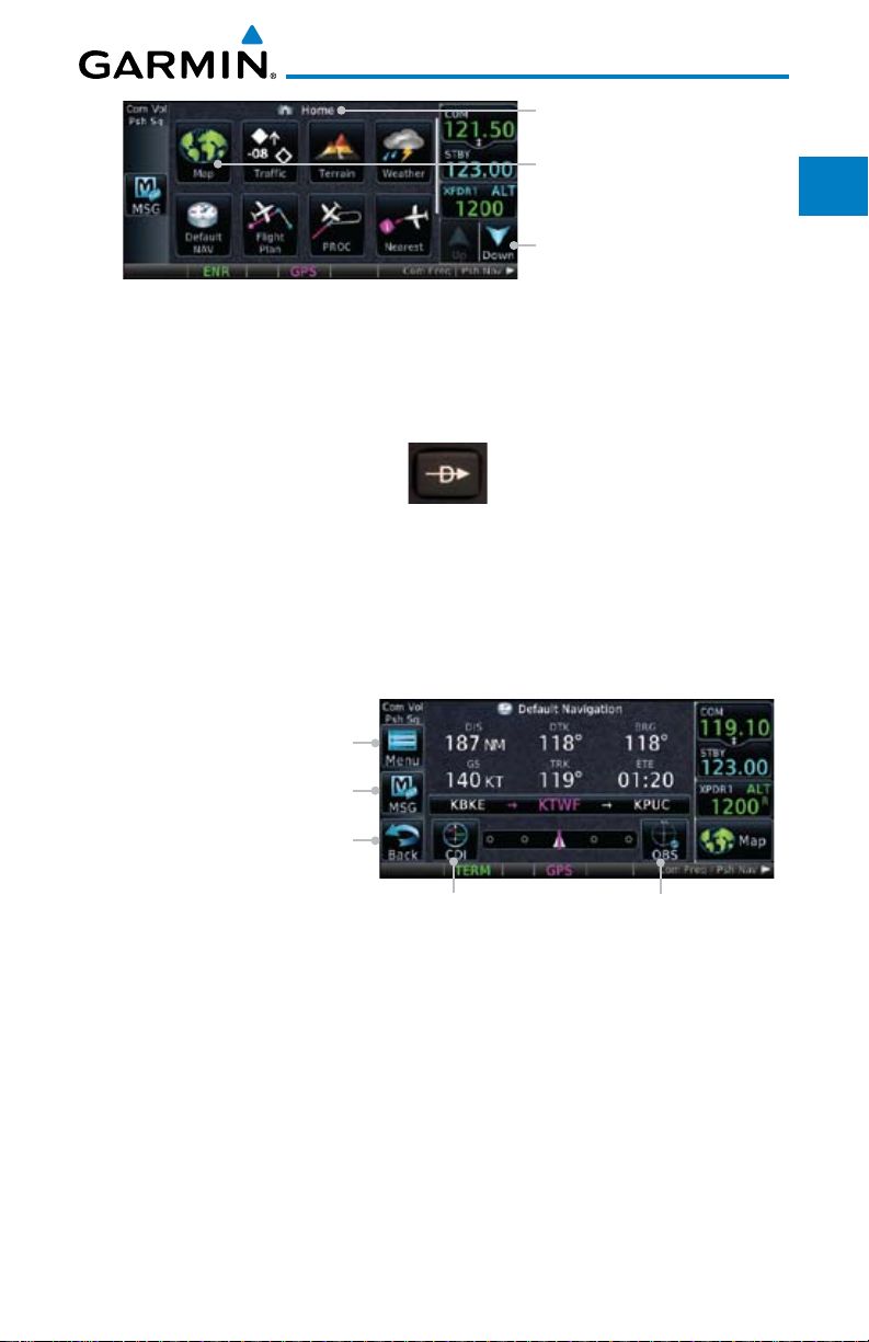
Figure 1-6 Home Page
Page Or Function Name
Touch The Key To
Access The Function
Touch Arrow Or Touchscreen
And Drag Finger To Scroll
Screen For More Keys
Foreword
Getting
Started
Xpdr Ctrl
Com/Nav
1.3.2.4 Direct-To Key
The Direct-To key provides access to the direct-to function, which allows you
to enter a waypoint and establishes a direct course to the selected destination.
Figure 1-7 Direct-To Key
Direct-To
Wpt Info
1.3.2.5 Touchscreen Keys
Touchscreen keys are placed around the display. The keys vary depending on
the page selected. Touch the key to perform the function or access the described
Traffic
information.
Terrain
Touch To View Menu Items
Touch To View Messages
Touch To View Previous Page
Touch To Select CDI Source
Figure 1-8 Touchscreen Key Control Example (Default Nav Page)
Touch To Toggle OBS
Weather
Nearest
Music
Utilities
FPL
Proc
Map
Garmin GTN 625/635/650 Pilot’s Guide
System
Messages
Symbols
Appendix
Index
1-5190-01004-03 Rev. B
Foreword
Getting
Started
Xpdr Ctrl
Com/Nav
FPL
Direct-To
Proc
Wpt Info
1.4 Unit Power Up
The GTN 6XX System is integrated with the aircraft electrical system and
receives power directly from electrical busses. The GTN 6XX and supporting
sub-systems include both power-on and continuous built-in test features that
exercise the processor, memory, external inputs, and outputs to ensure safe
operation.
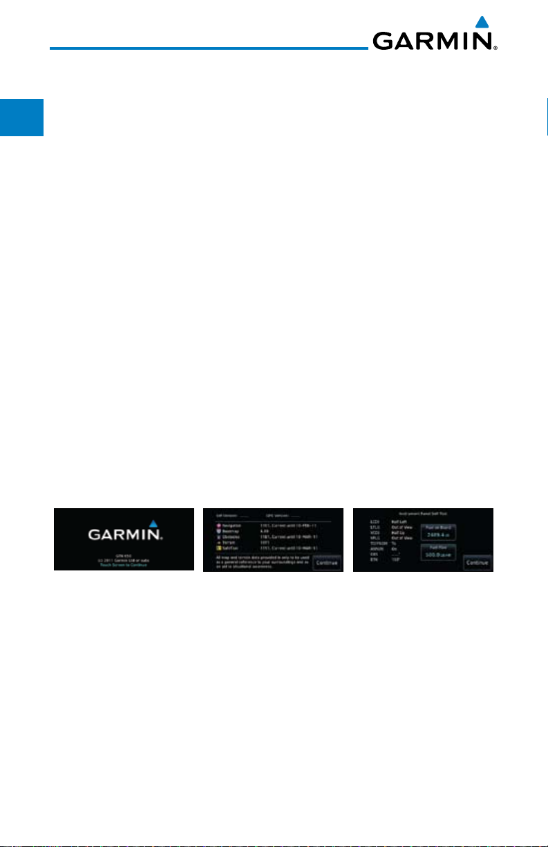
1.4.1 Start-Up Screens
During system initialization, test annunciations are displayed. All system
annunciations should disappear typically within the first 30 seconds after
power-up. Upon power-up, key annunciator lights also become momentarily
illuminated on the GTN 6XX display bezel.
The splash screen displays the following information:
• Copyright
Map
Traffic
Terrain
Weather
Nearest
Music
Utilities
System
Messages
Symbols
Appendix
• DatabaseListandSystemversion
• InstrumentPanelSelf-Test
Current database information includes valid operating dates, cycle number,
and database type. When this information has been reviewed for currency (to
ensure that no databases have expired), the pilot is prompted to continue.
Databases that are not current will be shown in amber.
2 - SW & Database
Versions & Dates
Figure 1-9 System Startup Pages
3 - Panel Self-Test1 - Copyright
Index
1-6
Garmin GTN 625/635/650 Pilot’s Guide
190-01004-03 Rev. B
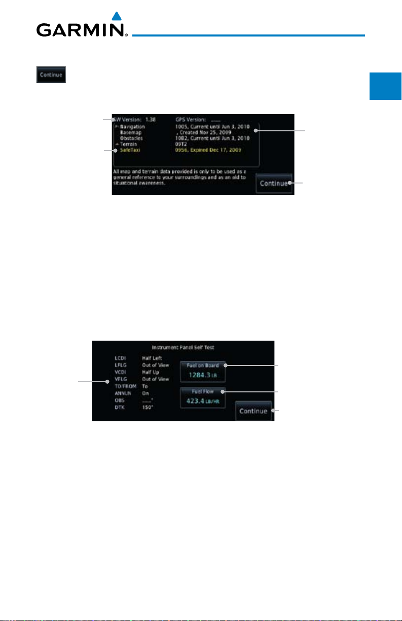
1.4.2 Database Verification and Fuel Settings
1. When the System and Database Version page appears, check
to ensure databases are current. Then, touch Continue.
Software and GPS
Engine Versions
Check For Any
Messages
Figure 1-10 System Startup Pages
2. When the Instrument Panel Self-Test and Fuel Setting page
appears, check to ensure that the CDI/HSI outputs and
other displayed data are correct on the external interfaced
equipment.
Check To
Ensure
Required
Databases Are
Present And
Current
Touch To
Continue To
Home Page
Foreword
Getting
Started
Xpdr Ctrl
Com/Nav
FPL
Direct-To
Proc
Wpt Info
Map
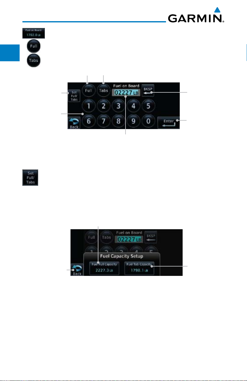
3. Touch each of the Fuel value keys and set the appropriate
values as desired. Fuel capacity is shown in either gallons or
pounds as set in the Units feature of System mode.
Touch To Set
Current Fuel
Start-Up
Instrument
Panel Test
Conditions
Figure 1-11 Instrument Panel Self-Test & Fuel Settings Page
Quantity
Touch To Set
Fuel Flow
Touch To Continue
To Home Page
Traffic
Terrain
Weather
Nearest
Music
Utilities
System
Messages
Symbols
Appendix
Index
Garmin GTN 625/635/650 Pilot’s Guide
1-7190-01004-03 Rev. B
Foreword
Getting
Started
Xpdr Ctrl
4. When the Fuel on Board value is selected, touch the Fuel on
Board key to display the Fuel on Board values. Touch the Full or
Tabs keys to display those values after they have been set.
Touch To
Display Fuel
Full Capacity
Touch To
Display Fuel
Tabs Capacity
Com/Nav
FPL
Direct-To
Proc
Wpt Info
Map
Traffic
Terrain
Weather
Nearest
Music
Utilities
System
Touch To Set
Fuel Full or Tab
Capacity
Touch To
Delete
Characters
Touch Keys
To Select Fuel
Capacity Values
Touch To
Accept Fuel on
Board Values
Selected Fuel
on Board
Capacity
Figure 1-12 Fuel On Board Page
5. Touch the Set Full/Tabs key to set the fuel values for Fuel
Full Capacity and Fuel Tab Capacity. After setting the fuel
values, touch the Back and then the Enter keys to return to
the Instrument Panel Self Test page.
Touch To
Set Fuel Full
Capacity
Touch To Return
To Fuel On
Board Display
Figure 1-13 Fuel Capacity Setup Page
Touch To
Set Fuel Tab
Capacity
Messages
Symbols
Appendix
Index
1-8
Garmin GTN 625/635/650 Pilot’s Guide
190-01004-03 Rev. B
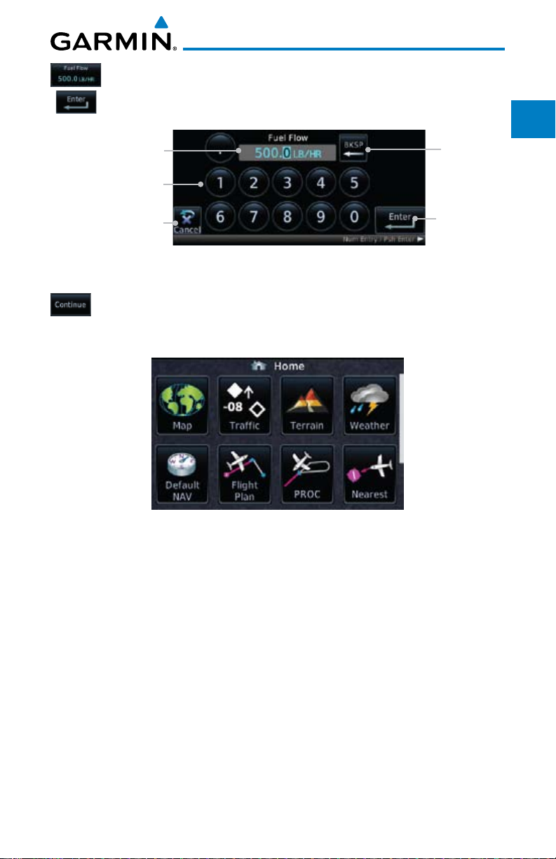
6. On
the Instrument Panel Self Test page
key and then use the numeric keypad to set those values. Touch
the Enter key after selecting the Fuel Flow values.
Selected Fuel
Flow Value
Touch Keys To Select
Fuel Flow Values
Touch To Cancel
Selection And Return
To Previous Page
, touch the Fuel Flow
Touch To
Delete
Characters
Touch To
Accept Fuel
Flow Values
Foreword
Getting
Started
Xpdr Ctrl
Com/Nav
FPL
Figure 1-14 Fuel Flow Setup Page
7. After returning to the Instrument Panel Self-Test page and the
fuel values have been set, touch the Continue key to advance
to the Home page.
Figure 1-15 Home Page
Direct-To
Proc
Wpt Info
Map
Traffic
Terrain
Weather
Nearest
Music
Utilities
System
Garmin GTN 625/635/650 Pilot’s Guide
Messages
Symbols
Appendix
Index
1-9190-01004-03 Rev. B
Foreword
Getting
Started
Xpdr Ctrl
Com/Nav
FPL
Direct-To
1.5 System Operation
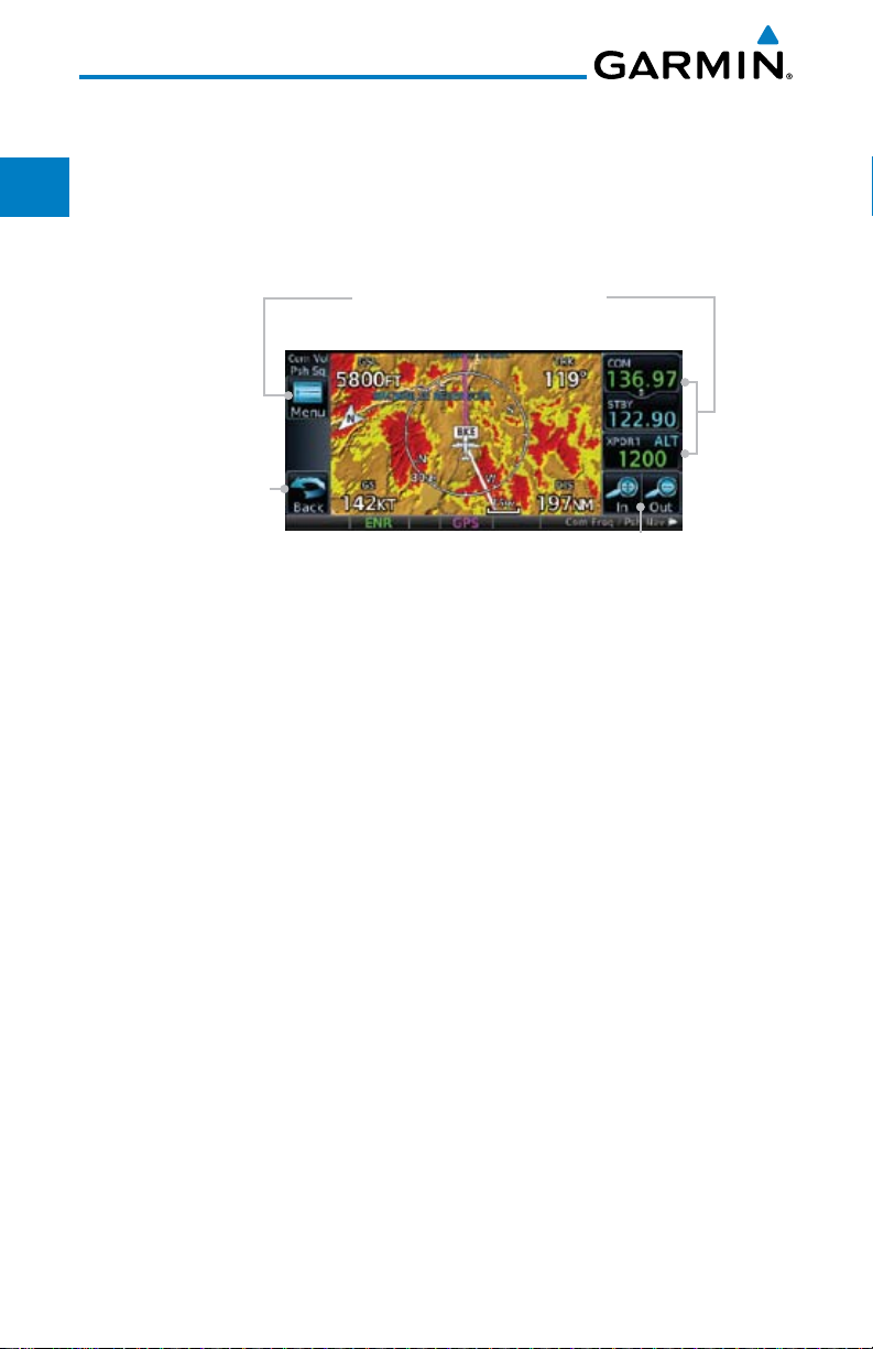
1.5.1 Using the Touchscreen Key Controls
Except for the knobs, the HOME key, and Direct-To key on the bezel, the
controls for the GTN 6XX are located on the display and activated by your
touch.
Touchscreen Keys -
Touch to Toggle Activation
Proc
Wpt Info
Map
Traffic
Terrain
Weather
Nearest
Music
Utilities
System
Messages
Back to
Previous Page
Touch to Zoom
In and Out
Figure 1-16 On-Screen Keys and Active Display Areas
1.5.2 Setup Page
GTN 6XX system settings are managed from the System page. The
following settings can be changed:
• SystemStatus
• GPSStatus
• ExternalLRUs
• Setup
• AlertsSettings
• UnitsSettings
• Audio
• OwnshipSymbol
• Backlight
Symbols
Appendix
Index
1-10
Garmin GTN 625/635/650 Pilot’s Guide
190-01004-03 Rev. B