

Page 1
SIRIUS SATELLITE WEATHER
REFERENCE MANUAL
FURUNO ELECTRIC COMPANY
www.furuno.co.jp
Page 2
SIRIUS SATELLITE WEATHER
REFERENCE MANUAL
The purpose of this manual is to provide operating procedures for Navnet NN3D’s
Sirius Satellite Weather capability. An optional Sirius Weather Receiver BBWX2
and Sirius subscription are required. This manual is provided in addition to the
Navnet NN3D operator’s manual, which fully covers operating procedures for the
NavNet NN3D system. Sirius weather coverage is currently only available in U.S.
and Canada.
Disclaimer – The weather information is subject to service interruptions and may contain errors or
inaccuracies and consequently should not be relied upon exclusively. The service is provided as is.
You are urged to check alternate weather information sources prior to making safety related
decisions. You acknowledge and agree that you shall be solely responsible for use of the
information and all decisions taken with respect thereto. By using this service, you release
and waive any claims against Sirius Satellite Radio Inc., WSI, Navcast Incorporated and Furuno
with regard to this service. If you do not have the subscription agreement, you will nd a copy at:
www.sirius.com/marineweather/marineweather_terms_and_conditions.pdf
Or call 1-800-869-5480 to have a copy sent to you.
FURUNO ELECTRIC COMPANY
www.furuno.co.jp
Page 3

Weather
1.1 Weather Display Overview
When connected to the Sirius Weather Receiver BBWX2, this MFD will display current
and forecasted weather information for your area. Real time updating ensures that you
have up-to-the-minute weather information for your area, as well as any other area in
the U.S.
Information provided by the Sirius Marine Weather service is advisory nature only.
You, the customer, agree to release FURUNO ELECTRIC CO., LTD., Sirius Satellite
Radio Inc., Navcast Inc. and WSI Corporation from any and all claims arising from the
use of this service, and you acknowledge that you have read the terms of your subscription agreement and agree to all the terms therein. If you do not have the subscription agreement, you will find a copy at: www.sirius.com/marineweatheragreement or
call 1-800-869-5480 to have a copy sent to you.
Before using the weather application:
• Obtain an optional Sirius Weather Receiver BBWX2.
• Obtain a Sirius weather service subscription. Contact Sirius Satellite Radio INC., for
further details.
• After connecting and powering up both the BBWX2 and the associated MFD displays, it may take up to 30 minutes for your MFD to receive/accumulate WX data
from the BBWX2.
• If, during the installation of the equipment, the Installation Wizard fails to acknowledge the existence of the BBWX2, Sirius-related menus will not appear. Confirm
that the equipment acknowledges the Sirius receiver.
1
Page 4
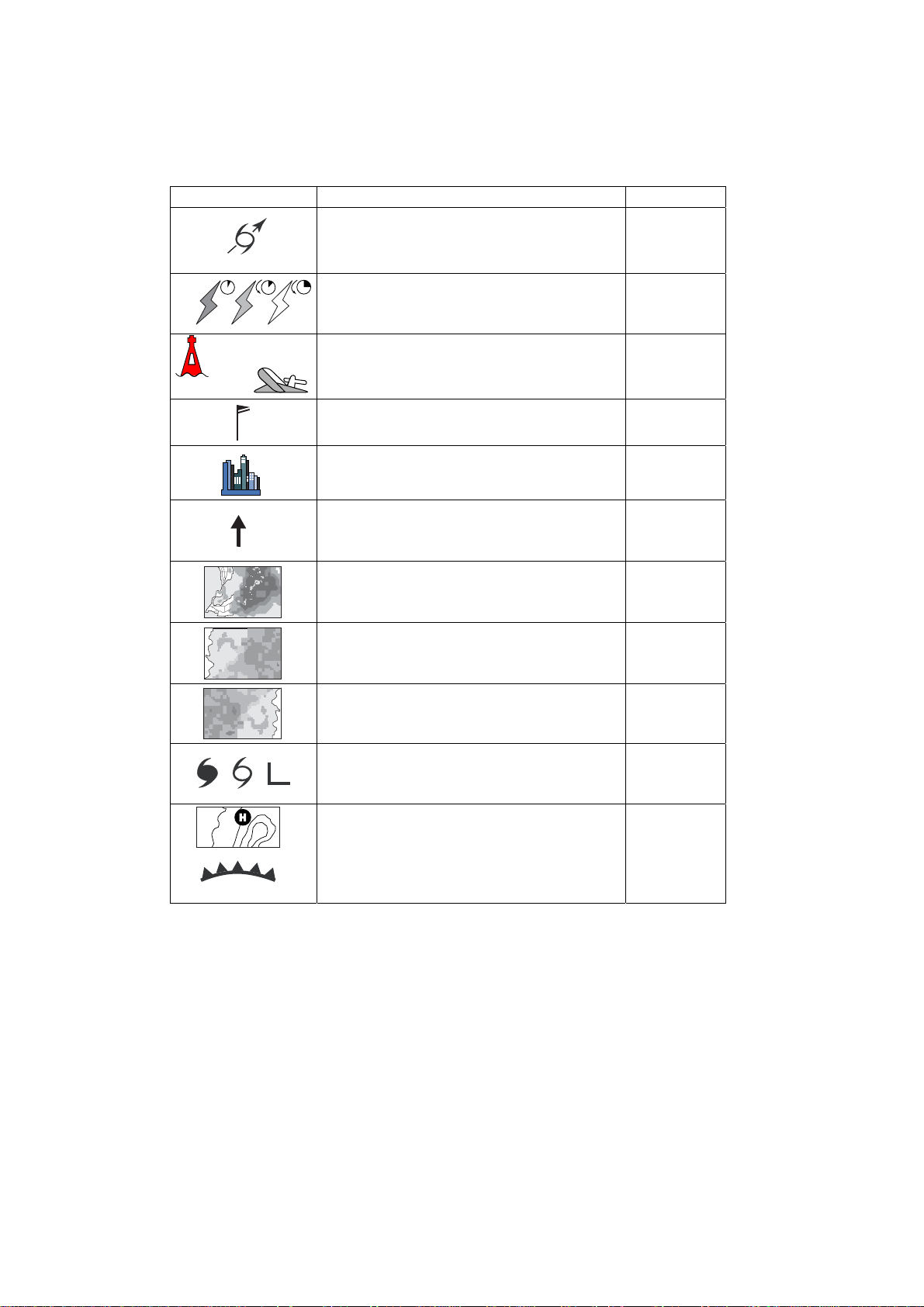
1.2 Weather Icons
The table below shows the weather icons that appear the Sirius Satellite Weather display. These icons can be shown or hidden from the Weather menu.
Icon Meaning
Pink Storm cast
Dark yellow (recorded in last 0-5 min.)
Medium yellow (recorded in last 5-10 min.)
Light yellow (recorded in last 10-15 min.)
Buoy or
CMAN sta.
Buoy: Red
CMAN station: Grey
Airplane: White
Pink
Grey Cities
Dark blue
Green-red
Red-blue
Green (Rain)
Blues (Snow)
Pinks (Mixture)
Grey (Historical)
Red (Current)
Orange (Forecast)
Color
Lightning
Surface
observation
stations
Wind
Waves
CANRAD
(Canadian
radar)
Sea surface
temperature
NOWRAD
(USA RADAR)
Storm tracks
etc.
For details, see page 7-6.
Surface
pressure
2
Page 5
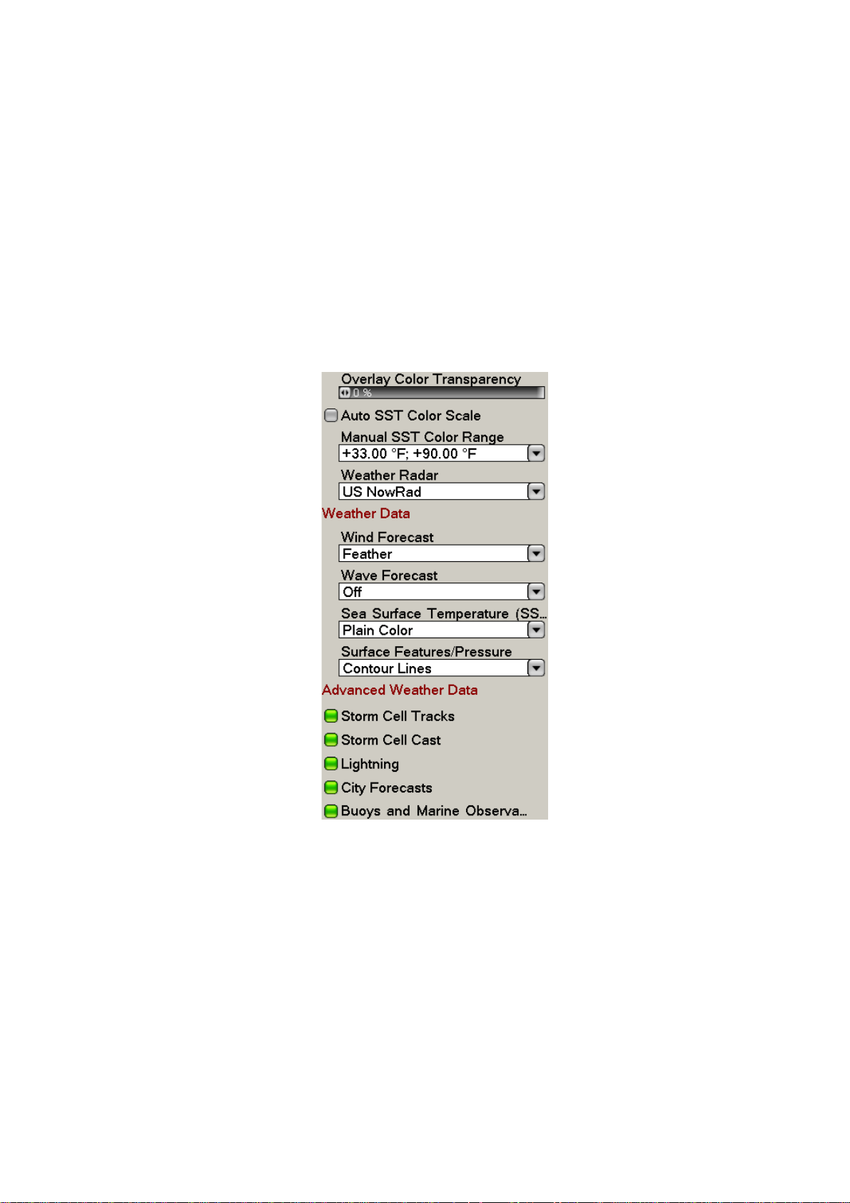
1.3 We a t he r Me nu
The Weather menu lets you adjust the following weather-related items:
• Overlay transparency
• Color scale
• Weather radar (US or Canada)
• Standard weather data
• Advanced weather data
1.3.1 Displaying the Weather Menu
1. Press the MENU key to open the menu.
2. Use the RotoKey to open the Weather-Sirius menu.
3. Use the RotoKey to select the weather item that you want to show or hide.
4. Push the RotoKey to alternately turn the item on and off.
5. Press the MENU key to close the menu.
3
Page 6

1.3.2 Weather Menu Description
Overlay Color Transparency
Adjust the transparence level of the weather overlay. Select this item with the RotoKey
and push the RotoKey. Rotate the RotoKey to set and then push it to confirm setting.
The higher the value the greater the transparency of the overlay.
Auto SST Color Scale
Enable/disable automatic adjustment of sea surface temperature color scale according to sea surface temperature.
Manual SST Color Range
Set the SST color range when Auto SST Color Scale is disabled. The setting range is
+00.00 to 99.99 (degrees Fahrenheit).
Weather Radar
Select the weather radar to use USA NOWRAD (USA) or CANRAD (Canada). NOWRAD shows the type and level of precipitation. The "Level" number shown below is a
figure of reflectivity from a weather radar. The larger the level number, the stronger the
precipitation.
Precipitation indication on NOWRAD.
Weather radar color Precipitation type Level
Light green Rain 15-19 dBz
Medium green Rain 20-29 dBz
Dark green Rain 30-39 dBz
Yellow Rain 40-44 dBz
Orange Rain 45-49 dBz
Light red Rain 50-54 dBz
Dark red Rain over 55 dBz
Light blue Snow 5-19 dBz
Dark blue Snow over 20 dBz
Light pink Mixed 5-19 dBz
Dark pink Mixed over 20 dBz
Precipitation indica tion on CANRAD
Weather radar color Level (mm per hour)
Transparent (low precipitation) 0.00 to 0.20 mm/hr
Light green 0.21 to 1.00 mm/hr
Medium green 1.01 to 4.00 mm/hr
Dark green 4.01 to 12.00 mm/hr
Yellow 12.01 to 24.00 mm/hr
Orange 24.01 to 50.00 mm/hr
Light red 50.01 to 100 mm/hr
Dark red over 100.01 mm/hr
4
Page 7

Weather Data
n
t
Wind Forecast
Select how to show the wind forecast. There are two types of wind icon styles: Vane
feathers and Plain colors. Vane feathers also show you wind speed and direction, but
give you more details about the wind speed per the description shown below.
3-7 8-12
13-17
18-22 23-27
28-32 33-37
Wind Force 10.0 kt
Wind Direction 306.5
M
Wave Height +11.0 ft
Wave Direction 141.5
M
Wave Period 0m00s
38-42 43-47 48-52
53-57 58-62 63-67 68-72
Place cursor on a wind icon or
anywhere on a body of water
and hit the left-click button to
show wind and wave informatio
for that area.
73-77
78-82 83-87 88-92 93-97 98-102
(kt)
Waves Forecast
The Waves layer depicts wave height, with a dark blue arrow whose length increases
with wave height. To find wave information place the cursor on a wave symbol and hit
hit the left-click button.
Wind Force 30.0 kt
Wind Direction 186.5
Wave Height +12.50 f
Wave Direction 156.5 M
Wave Period 0m00s
M
5
Page 8

Sea Surface Temperature
This data layer shows the temperature of the sea surface in shades of red and blue,
in order of descending temperature.
Surface Features/Pressure
Enable this feature to get surface pressure with meteorological symbols. The cursor
may be placed on an surface pressure icon to show the name of the surface pressure.
Seasurface temp icon
L
1010
1012
Color
Blue High pressure
Red Low pressure
Red Warm front
Blue Cold front
Purple Occluded front
Red-blue Stationary front
Brown Trough
Red Squall line
Brown Dry line
Grey Isobars
Meaning
6
Page 9

Advanced Weather Data
Storm Tracks
The storm track icons show significant storms in your area. These include tropical disturbances, depressions, storms and cyclones, hurricanes, typhoons and super typhoons. These symbols are displayed in three different colors: Grey, historical; Redcurrent, and Orange, forecast.
Storm tracks
Icons
Hurricane (Category 1-5)
Tropical storm
Tropical disturbance, Tropical depression
Meaning
To find simple storm tracks information, place the cursor on the icon. For more de-
tailed information, press the left-click button.
Simple storm tracks information
Detailed storm tracks infomration
7
Page 10

Storm Cell Cast
You can find the direction and speed of a storm by placing by placing the cursor on
the icon. For more detailed information, press the left-click button.
Simple storm cell cast information
Detailed storm cell cast information
8
Page 11

Lightning
g
The lightning icons show where lightning has struck, within the last 5, 10 and 15 minutes. The icon's fill color indicates how recent the lightning strike was, as shown in the
table below. The number of lightning bolt markers indicates the number of times lightning has struck.
Lightning
icons
.Description of lightning icons
Lightning
icon
Color Period
Orange Last 0-5 min.
Medium yellow Last 5-10 min.
Light yellow Last 10-15 min.
To find simple lighting information, place the cursor on it. For more detailed informa-
tion, push the left-click button.
Simple lightning information
Detailed li
htning information
9
Page 12

City Forecasts
City weather forecasts are available wherever city icons are shown. For simple information, place the cursor on the city icon ( ). For more detailed information, push
the left-click button.
Simple city information
Detailed city information
10
Page 13

Buoys
You can check the historical or current weather information at buoys.
For simple information, place the cursor on the buoy icon ( ), etc. For more de-
tailed information, push the left-click button.
Simple buoy information
Detailed buoy data
Scroll for
more data
11
Page 14

1.4 Weather Reports
Marine zone forecasts, marine warnings, tropical information and weather alerts are
sent to your unit. You can view them on the Weather menu, by opening respective sub
menu.
Sirius sends warning messages to alert you to bad weather. You can view these messages by opening the Weather-Alert Box menu.
1.4.1 Marine Zone Forecast
These forecasts cover the following areas.
• US coastal weather forecasts
• US offshore forecasts
• High seas forecasts
• Great Lakes forecasts
• Near Shore forecasts
• Canadian coastal weather forecast.
12
Marine zone forecast
Page 15

1.4.2 Marine warning
Display the marine warnings (US coastal or near shore).
NO REPORT AVAILABLE FOR THIS MARINE ZONE.
1.4.3 Tropical Statement
Below is an example of a tropical weather statement.
13
Page 16

1.4.4 Marine WatchBox
The message "Weather Alarm, Press Menu Button" appears on the status bar when
a tornado or thunderstorm warning is received. To view the details of the warning,
press the MENU key to open the Alert Box in the Weather menu. The message is au-
tomatically opened in the Alert Box. A typical warning message is shown below.
You can show or hide the WatchBox warning message with Sirius Marine WatchBox
in the Alarm-General menu.
14
 Loading...