

Page 1
Furuno’s new
NavNet 3D
system leads
the way with
top imagery
and features
uruno’s new NavNet
3D system sets the
F
new standard for integrated marine electronic
navigation systems. The
NavNet 3D chartplotter
and radar provide a level of
capability and performance
that is superior to any previous Furuno system and is
a challenge to the systems
offered by other manufacturers. Available with integrated 8.4-inch or 12.1inch diagonal color LCD
screens or as a black box
system that can support up
to 10 multifunction displays, NavNet 3D will fulfill the electronic navigation needs of virtually any
size vessel, providing information from system sensors including WAAS,
GPS, AIS, radar, sonar,
Sirius Marine Weather,
Weatherfax, weather station, sailing instruments,
engine instruments and IP
video cameras. The system
also interfaces with the
autopilot, a new GPS compass system and the audio
program from the Sirius
Satellite receiver.
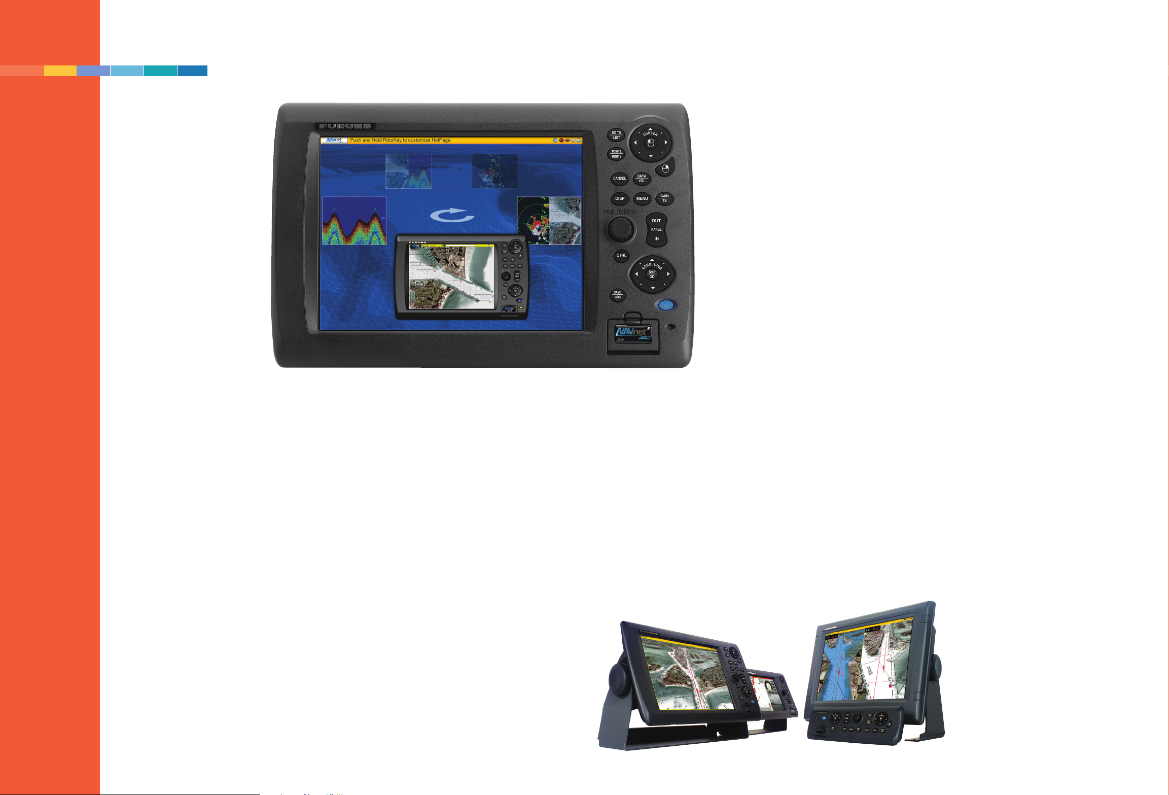
The display screen and
the controls for the most
often used functions, the
chartplotter and radar, are
the heart of any multifunction electronic navigation
system. The NavNet 3D
system is available in three
formats: integrated dis-
product images and screen shots courtesy Furuno
Impressive
multifunction
integration
play/processor units with
8.4-inch diagonal, VGA
(640 x 480 pixel) color
LCD screen; a 12.1-inch
SVGA (800 x 600 pixel)
display; and a black box
version that is compatible
with virtually any multisync display. The black box
system will support up to
1280 x 1024 pixel, SXGA
resolution. The LCD display units can be flush or
trunnion mounted and
provide two SD cards on
their front panels.
SD card slots are also
provided on the Ethernetconnected control module
for the black box system,
eliminating the need to
access to the remote central
processor unit when
switching cards.
A chartplotter can be no
better than its charts. The
NavNet 3D system is
delivered with a complete
By Chuck Husick
Left, the
NavNet 3D
units use trackpads and a
rotary knob
called a
RotoKey to
select and contol display elements. Lower
right, Furuno
revamped both
the NavNet
software and
its display hardware. The result
is a tight integrated system.
set of MapMedia’s NOAA raster,
vector and bathymetric charts
for the U.S. (including Alaska
and Hawaii) stored in its internal memory. Charts can be
updated at any time by downloading the latest versions from
the Furuno website
(www.NavNet.com) onto an SD
card for transfer to the plotter’s
internal memory. Satellite image
files appropriate for the planned
navigation area are also obtained
from the Furuno Web site. Since
the satellite photo files for total
U.S. coverage far exceed the system’s memory capacity, the picture files for a defined planned
navigation area, for example the
coastline from northern New
Jersey to Cape Cod, are downloaded and transferred to the
internal memory. MapMedia,
S57-based charts for foreign
waters not covered by NOAA,
are downloaded in similar fashion, however there will likely be
a charge for the data since virtually all countries except the U.S.
copyright and charge for their
charts.
The chart images are created
from the NOAA and other official cartography using GIS (geographic information system)
technology. Information in GIS
form can be displayed at virtually any desired scale, with the
amount of detail information
continuously matched to the
resolution of the display system.
In the NavNet 3D system the
maximum range setting will display the entire NOAA hemisphere chart. When zoomed all
the way in the chart will be seen
at a scale of 1/8th nm.
Seamless zooming
Furuno’s TimeZero technology,
a combination of software, a
high-speed processor and a powerful graphics engine makes the
image flow smoothly, without
interruption and without the
need for screen re-draw. The
scrolling pad makes it easy to
move from the vessel’s present
position to anywhere in charted
U.S. and Bahamian waters and
zoom in to examine the smallest
detail. Regardless of the distance
to the location you have chosen
to examine, even thousands of
miles from your actual location,
a short stroke of the ship/3D
key in the center of the scrolling
pad will instantly restore the
normal vessel-centered chart
view. A long stroke of the combination ship/3D key in the
center of the scrolling pad toggles the display between 3D to
2D. In 3D display mode the
combination of the range key
and scrolling pad provides complete display perspective freedom similar to the image management found in Google Earth.
In addition to the display of
nautical charts, tide and current
information, the NavNet 3D
system’s Satellite Photo Fusion
technology integrates satellite
images of terrain and shallow
water areas with both raster and
vector charts. The satellite photos are precisely geo-referenced
to the chart in use. The photo
image is presented so that all
land areas are completely
opaque to provide maximum
detail (photo image resolution is
52
www.oceannavigator.com
www.oceannavigator.com
JANUARY/FEBRUARY 2008 OCEAN NAVIGATOR 53
Page 2
NavNet 3D combines sat photos
with electronic
charts and colorized
depth shading.
50 cm/pixel). Areas where
the images contain useful
shallow water bottom
details are made progressively transparent, pre-
senting both photo and
navigation chart information. Areas where the
photo contains no useful
navigation information are
made entirely transparent,
eliminating possibly confusing images of objects
that were on the water
when the satellite image
was created and assuring
that all charted navigation
information is clearly in
view.
The system’s split screen
options, single, dual, three
or four windows, allow
simultaneous side-by-side
viewing of raster and vector charts, with photo
images fused with both
views. The Ethernet-connected Furuno FA 30/50
synthesized AIS receiver
can present information
from up to 100 AIS-
reporting vessels on the
chart screen and when
desired on the radar image.
Vessels that present a possibility of a close approach
or collision can be tracked
with automatic alerting for
those whose tracks portend
a close approach or possibility of collision. The use
of a frequency synthesizer
in the AIS receiver assures
that the unit will be able to
operate on other than the
two standard AIS-reporting
channels (87B and 88B) if
required by area specific
regulations.
Radar that looks twice
The most impressive feature of the new NavNet 3D
UHD radar equipment is
its unique ability to perform like two separate
radar sets, each scanning at
whatever ranges are appropriate for the navigation
situation. Unlike previous
dual range radar systems
whose performance was
limited by the need to use
the pulse length required
for the longest selected
range, the UHD manages
the transmitted pulse
length for each range independently, eliminating any
performance compromise.
The radar’s look twice
simultaneous dual range
capability is achieved by
double pulsing the magnetron, matching the duration of each alternate
transmitted pulse to the
selected range.
The full range of operator controls, range, gain,
sea state, interference rejection, rain suppression,
echo stretch, target trail,
variable range marker, electronic bearing line, etc.,
are available individually
for both ranges when the
system is operating in dual
range mode. Each radar
display can be operated
with an independent vessel
offset setting. The radar
image can be displayed in a
single, split, three or four
screen format and can be
overlaid on the chart/satellite photo image. The
radar’s performance is
additionally aided by automatically matching the
antenna rotation or sweep
speed to the longest range
in use (required to accommodate the longer pulse
lengths needed for longer
ranges), 48 rpm for short
ranges, 36 rpm for middle
distances and the standard
24 rpm for long ranges.
The new UHD radars
are available with RF
power ratings from 2 to 25
kw. Two radome antenna
models are available, 2 kw,
18-inch diameter, 24 nm
and 4 kw, 24-inch diameter, 36 nm maximum
range. The radomes are a
new wind tunnel proven,
low aerodynamic drag
design. Open array models
include a 4 kw/3.5 foot, 48
nm, 6 kw/4 foot, 64 nm,
12 kw, 72 nm or 25 kw
with 4- or 6-foot antennas,
maximum range 96 nm.
The digital signal processing (DSP) technology
employed in these new
units (and used to great
advantage in Furuno
sonar/fish finders) significantly improves the radar’s
ability to detect and accurately visualize small, often
difficult to detect targets.
Small boats and navigation
aids with very limited radar
cross sections are clearly
imaged. The on screen
radar image clearly shows
the effectiveness of the new
signal processing circuits in
suppressing antenna sidelobe response and in automatically managing main
bang response.
Automatic radar plotting
aid (ARPA), previously a
10-target tracking option
on Furuno radar sets in this
category is now standard
and is able to simultaneously track up to 30 targets. All tracked targets
within the selected range
will appear on both radar
screens when operating as a
dual range radar. All of the
AIS targets (up to 100) are
available on both screens.
The new UHD radars
are remarkably easy to
install since the entire radar
system, including the
receiver and all signal pro-
cessing electronics are
housed in the antenna unit
and connect to the NavNet
3D system using an Ethernet cable and a pair of 48volt DC power wires. Anyone who has dealt with the
multi-conductor cable of
20-plus single wires and a
miniature coax will
applaud Furuno’s use of a
single, easy-to-install Ethernet cable. Each radar (or
radars) and the majority of
the other sensors used in
the system are assigned
unique IP addresses, greatly simplifying setup, the
addition of sensors and
problem analysis if the
need arises. Two NMEA
2000 connectors provided
on the antenna housing
make it possible to connect
devices such as GPS
receivers, masthead wind
instruments or the Furuno
Weather Station to the system network without the
need to run additional
cables.
The series of manual
timing/tuning adjustments
formerly required on the
installation of a radar is
now accomplished automatically. The only manual
adjustment required at initial startup, matching the
radar’s lubber line to the
vessel’s longitudinal axis, is
accomplished at the radar
display.
The black box version of
the NavNet 3D system can
support up to 10 multifunction display screens.
The black box system’s
central processor supports
an extended mode in
which the data output is
shared across two screens,
providing a range of display choices from two
large individual screens to
as many as eight screen
windows. Control of each
display window (in both
the single unit and black
box versions of the system)
is accomplished by moving
the cursor into the boundary of the screen to be
controlled. No additional
control actions are
required. Highlighting the
boundary of the active
window signifies that the
controls are assigned to
that window.
Painless system integration
The majority of ancillary
sensors for the NavNet 3D
system, including the Sir-
Another example of how the
system can render sat photos
and raster
charts.
54 OCEAN NAVIGATOR JANUARY/FEBRUARY 2008
www.oceannavigator.com
www.oceannavigator.com
JANUARY/FEBRUARY 2008 OCEAN NAVIGATOR 55
Page 3

This Furuno
diagram shows
the various
sensor and
display
elements that
can be plugged
into the system
using Ethernet,
NMEA 0183 and
NMEA 2000.
ius Satellite weather receiver, Furuno Weatherfax
receiver, Network Fish
Finders, the FA/30/50 AIS
receiver, up to 4 IP video
cameras and a PC connect
to the 3D system via Ethernet, greatly simplifying
installation and control of
the system. Audio signals
from the Sirius receiver are
accommodated by the
NavNet 3D system,
including the provision of
a front panel audio volume
control (a feature frequently asked for in NavNet vx2
installations). Connections
to other sensors including
the Furuno Weather Station, the new GPS compass, Furuno’s new sailing
instruments and
engine/vessel data are
accomplished using
NMEA 2000 or NMEA
0183. NMEA 2000 is used
for communication
between the Network Fish
Finder and the sonar trans-
ducer to provide the transducer’s model number, frequency and date of manufacture information for use
in optimizing system performance by compensating
for known ageing effects in
the transducer.
The new NavNet 3D
system does more and is
significantly easier to manage than previous Furuno
chartplotter/radar multifunction systems whose
control logic remained
rather opaque even after
years of use. We believe
that the system’s userfriendly interface is in part
a result of Furuno’s investment in MaxSea and their
participation in the design
of the system software.
Examples of the new
way of doing things are
especially visible in the use
of point and click control
functions and the elimination of the need to
progress through menu
layers to select or change
functions or displays.
Almost everything is only
one click or a slight rotation of the RotoKey away.
The wisdom of Furuno’s
decision to use Ethernet as
the communication bus
beginning with the original
NavNet system in 2001 is
reinforced in NavNet 3D.
The plug and play nature
of the Ethernet bus system
is illustrated by the ease
with which an IP video
camera can be plugged into
a hub and the image it captures is displayed on the
screen and controlled from
the system’s scrolling pad.
Having seen all the new
features and capabilities of
this new system we can’t
help but wonder what’s
next. Perhaps the coming
year will see a new chart
image option, the ability to
overlay a raster chart on a
vector chart, providing the
navigator with the best of
both worlds: the familiar
and easy to use conventional chart image and
with a click, access to the
mass of data that is instantly accessible from the ENC
database. In the area of
sensors, an integrated video
surveillance camera using
both night vision TV and
an infrared camera would
likely be welcomed by
many navigators, as would
an effective look-ahead,
depth-scanning sonar.
■
56 OCEAN NAVIGATOR JANUARY/FEBRUARY 2008
www.oceannavigator.com
www.oceannavigator.com
JANUARY/FEBRUARY 2008 OCEAN NAVIGATOR 57
 Loading...