

Page 1

Owner's manual
N
Navigation
X
503E
Page 2

Thank you for choosing the Clarion NX503E as your navigator. Start using Clarion NX503E
right away. This document is the detailed description of the navigation software. You can
easily discover Clarion Mobile Map while you are using it; however, we still recommend that
you read this manual to fully understand the features and functions.
Easy navigation map updates
It is easy to keep the navigation system up to date. Simply download new map data from
Clarion’s portal site, store them on a microSD card and insert it into the Clarion NX503E via
the front card slot.
Latest Map Guarantee
When you start using the product, you have 30 days to download the latest available map free
of charge.
2 NX503E English
Page 3

Table of contents
1. Warnings and Safety information ......................................................... 6
2. Getting started......................................................................................... 7
2.1 Buttons and other controls on the screen............................... ... .... ..................8
2.1.1 Using keyboards ................................................................................ ..................10
2.1.2 Beyond single screen tap................................ .....................................................11
2.2 Map screen . .... ... .... .... ... .... ... .... .... ............................................................. ... ..12
2.2.1 Navigating on the map.................................... .....................................................12
2.2.2 Position markers ................................................................................ ..................14
2.2.2.1 Vehimarker and Lock-on-Road..................................................................................14
2.2.2.2 Selected map location (Cursor) and selected map object.........................................14
2.2.3 Objects on the map . .............................................................................................14
2.2.3.1 Streets and roads........................................................................................................14
2.2.3.2 Turn preview and Next street.....................................................................................15
2.2.3.3 Lane information and Signposts ................................... ..... ..... ...... ..... .......... ...... ..... ...16
2.2.3.4 Junction view................................................................. .......... ...... ..... .......... ...... .... ....17
2.2.3.5 Motorway exit services............................ ...................................................................17
2.2.3.6 3D object types ........................................................................................................ ...18
2.2.3.7 Elements of the active route.......................................................................................18
2.2.3.8 Traffic events...................................................................... ..... ...... ..... ..... ........... ..... ...19
2.2.4 Manipulating the map............................................ ..............................................20
2.2.5 Quick menu............................................. .............................................................21
2.2.6 Checking the details of the current position (Where Am I?)..............................24
2.3 Navigation Menu...........................................................................................25
3 On-road navigation................................................................................ 27
3.1 Selecting the destination of a route................................................... ... .........27
3.1.1 Combined Search.............................................. ...................................................28
3.1.1.1 Combined Search - Navigating to a recent destination (History).............................30
3.1.1.2 Combined Search - Navigating to a Favourite destination.......................................30
3.1.1.3 Combined Search - Navigating to an address...........................................................31
3.1.1.4 Combined Search - Navigating to a Place of Interest...............................................32
3.1.1.5 Combined Search - Navigating to a Place of Interest by its category......................33
3.1.2 Entering an address or a part of the address........................................................34
3.1.2.1 Entering an address ...................................................................................................34
3.1.2.2 Entering the midpoint of a street as the destination..................................................37
3.1.2.3 Selecting an intersection as the destination...............................................................38
3.1.2.4 Selecting a city/town centre as the destination....................................... ...................39
3.1.2.5 Entering an address with a postal code.................................................................. ...41
3.1.2.6 Tips on entering addresses quickly............................................................................43
3.1.3 Selecting the destination from the Places of Interest..................... ... .. .. ... .. ..... .. ..43
3.1.3.1 Quick search for a Place of Interest ........ ..................................................................43
3.1.3.2 Searching for a Place of Interest using preset categories.........................................45
NX503E English 3
Page 4

3.1.3.3 Searching for a Place of Interest by category ...........................................................47
3.1.3.4 Searching for a Place of Interest by name......................................... ........................49
3.1.3.5 Searching for a Place of Interest by its Phone Number............................................52
3.1.3.6 Selecting nearby assistance from 'Where Am I?'.......................................................53
3.1.4 Selecting a map location as the destination.................................... .....................55
3.1.5 Selecting the destination from your Favour ites..................................................55
3.1.6 Selecting your Home location.............................................................................56
3.1.7 Selecting a recent destination from the History.................... ..............................57
3.1.8 Entering the Coordinate of the destination..........................................................58
3.1.9 Navigate to a location stored in a photo..............................................................60
3.1.10 Building a route from the list of destinations (Create Route)................ ...........61
3.2 Viewing the entire route on the map.............................................................62
3.3 Checking route parameters and accessing route related functions.. ... .... ... ..62
3.4 Modifying the route.......................................... .... ... .... ... .... .... ... .... ... .... .... .....63
3.4.1 Selecting a new destination when already having a route: New Route,
Waypoint or Final Destination.......................... ............................ .......................63
3.4.2 Setting a new starting position for the route.......................................................64
3.4.3 Editing the list of destinations (Edit Route)........................................................65
3.4.4 Pausing the active route.......................................................................................66
3.4.5 Cancelling the active route..................................................................................66
3.4.6 Checking route alternative s when planning the route.........................................67
3.4.7 Checking route alternative s for an existing route...............................................68
3.4.8 Changing the vehicle used in route planning................. .....................................69
3.4.9 Changing the road types used in route planning.................................................70
3.5 Saving a location as a Favourite destination..................... .... ... .... .... ... .... ... ..71
3.6 Saving a location as an alert point ................................................... ... .... ... ..72
3.7 Editing an alert point....................................................................................73
3.8 Watching the simulation of the route. ... .... .... ... .... ... .... .... ... .... ... .... ... .............74
4 Off-road navigation................................................................................ 76
4.1 Selecting the destination of the route.............................. ... ...........................76
4.2 Navigating in off-road mode.........................................................................76
5 Reference Guide..................................................................................... 77
5.1 Concepts........................................................................................................77
5.1.1 Smart Zoom .............................. ...........................................................................77
5.1.2 Daytime and night colour themes..................................... ...................................77
5.1.3 Tunnel view .........................................................................................................77
5.1.4 Route calculation and recalculation ............................. .......................................78
5.1.5 Green routing.................................... ...................................................................80
5.1.6 Road safety cameras and other proximit y alert points........................................80
5.1.7 Speed limit warning.................. ... ..... .. .. ... .. .. ... .... ... .. .. ... .. ..... .. .. ... .. .. ..... ... .. .. ... .. .. ..81
5.1.8 Traffic information in route planning...................................... ... .... ... .. ... .. .. ..... .. ..82
4 NX503E English
Page 5

5.1.8.1 Real-time traffic information (TMC) ................................. ........................................82
5.2 'More' menu...................................................................................................84
5.3 Settings menu .......................................................... .... .... ... .... ... .... ... .... .........85
5.3.1 Sound and Warnings............................................................................................86
5.3.2 Customise Quick menu.............................. ..........................................................88
5.3.3 Traffic settings.....................................................................................................88
5.3.4 Route settings......................................................... ..............................................89
5.3.5 User profiles....................................................................................... ..................93
5.3.6 Map settings.........................................................................................................93
5.3.7 Visual guidance settings........................................................ ..............................95
5.3.8 Display settings....................................................................................................96
5.3.9 Regional settings........................................................... .......................................96
5.3.10 Trip monitor settings ................................................................................ .........97
6 Glossary................................................................................................... 98
7 End User Licence Agreement.............................................................. 100
8 Copyright note...................................................................................... 106
NX503E English 5
Page 6

1. Warnings and Safety information
The navigation system helps you find your way to your destination with a connected GPS
receiver. Clarion Mobile Map does not transmit your GPS position; others cannot track you.
It is important that you look at the display only when it is safe to do so. If you are the driver of
the vehicle, we recommend that you operate Clarion Mobile Map before you start your
journey. Plan the route before your departure and stop if you need to change the route.
You must obey the traffic signs and follow the road geometry. If you deviate from the
recommended route, Clarion Mobile Map changes the instructions ac cordingly.
Never place where it obstructs the driver's view, where it is in the deployment zone of an
airbag or where it might cause injuries in an accident.
For more information, consult the End User Licence Agreement (page 100).
6 NX503E English
Page 7

2. Getting started
Clarion Mobi le Map is optimis ed for in-car use. You can use it eas ily by tapping th e screen
buttons and the map with your fingertips.
When using the navigation software for the first time, an initial setup process starts
automatically. Do as follows:
1. Select the written language of the application interface. Later you can change it in
Regional settings (page 96).
2. Read the End User Licence Agreement. Tap
3. The Configuration wizard starts. Tap
4. Select the language and speaker used for voice guidance messages. Later you can
change it in Sound and Warnings settings (page 86).
5. If needed, modify the time format and unit settings. Later you can change them in
Regional settings (page 96).
to continue.
to continue.
NX503E English 7
Page 8

6. If needed, modify the default route planning options. Later you can change them in
Route settings (page 89).
7. The initial setup is now complete. The Configuration wizard can be restarted later from
the Settings menu (page 85).
After the initial setup, the Map screen appears and you can start using Clarion Mobile Map.
2.1 Buttons and other controls on the screen
When you are using Clarion Mobile Map, you usually tap buttons on the touch screen.
Type Example Description How to use it
Button
Button
with
value
Tap it to initiate a function,
to open a new screen, or to
set a parameter.
Some buttons display the
current value of a field or
setting. Tap the button to
change the value. After the
change, the new value is
shown on the button.
Tap it once.
Tap it once.
Icon
List
8 NX503E English
Shows status information.
When you need to select
from several options, they
appear in a list.
Some icons also function
as a button. Tap them
once.
Grab the list anywhere
and slide your f i ng e r up
or down. Depending on
the speed of the sliding,
the list will scroll fast or
slow, only a bit or till the
end.
Alternatively, move
between pages with the
and buttons
and tap the valu e t ha t
you want.
Page 9

Radio
button
Switch
Slider
Virtual
keyboard
When there are only a few
choices, radio buttons may
be used instead of lists.
Only one value can be
selected.
When there are only two
choices, a checkmark
shows whether the feature
is enabled.
When a feature can be set
to different values in a
range, Clarion Mobile Map
shows an indicator on a
gauge that displays and
sets the value.
Alphabetic and
alphanumeric keyboards to
enter text and numbers.
Tap one of the buttons to
select a new value.
Tap it to turn the switch
on or off.
Drag the handle to
move the slider to
its new positi on .
Tap the slider
where you want
the handle to
appear; the thumb
jumps there.
Each key is a touch
screen button.
NX503E English 9
Page 10

2.1.1 Using keyboards
You only need to enter letters or numbers when needed. You can type with your fingertips on
the full-screen keyboards and you can switch between various keyboard layouts, for example
English, Greek or numerical.
Task Instruction
Switching to another
keyboard layout, for
example from an English
keyboard to a Greek
keyboard
Correcting your entry on the
keyboard
Entering a space, for
example between a first
name and a family name or
in multi-word street names
Entering upper and lower
case letters
Tap the
keyboard layout from the list.
Tap
Tap and hold the button to delete several characters or the
entire input string.
Tap the
When entering a text, the first character appears in upper case
to remove the unneeded character(s).
button at the bottom centre of the screen.
button and select the new
Entering numbers and
symbols
Finalising the keyboard
entry (accepting the
suggested search result)
Finalising the keyboard
entry (opening the list of
search results)
Finalising the keyboard
entry (saving your input)
Cancelling the keyboard
entry (returning to the
previous screen)
while the rest of the text is in lower case. Tap
upper case letter or tap twice to turn on Caps Lock. Tap again
and lower case letters return.
Tap
characters.
Tap
Tap
Tap
Tap
to switch to a keyboard offering numeric and symbol
.
.
.
.
to enter an
10 NX503E English
Page 11

2.1.2 Beyond single screen tap
You usually need to tap the screen only once. However, some useful features can be
accessed with combined touch screen tapping. Those are the following:
Action Details
Tapping and holding
the screen
Tap and keep pressing the foll owing buttons to r each extra functions:
Gestures
(drag&drop)
Tap and hold
the Map screen appears.
Tap and hold any of the
and
scale the map continuously.
Tap and hold
several characters quickly.
Tap and hold
continuously.
You need to drag and drop the screen only in cases like:
Moving the handle on a slider.
Scrolling the list: grab the list anywhere and slide your finger up
or down. Depending on the speed of the sliding, t he list will
scroll fast or slow, only a bit or till the end.
Moving the map in map browsing mode: grab the map, and
move it in the desired direction.
buttons on the Map screen: you can rotate, tilt or
on keyboard screens: you can delete
or in long lists: you can scroll pages
on list and menu screens:
, , , , ,
NX503E English 11
Page 12

2.2 Map screen
2.2.1 Navigating on the map
A small live map is displayed on the Navigation Menu, as a part of the
button.
To enlarge this small map and open the Map screen, tap
This map shows the current position (the Vehimarker, a red arrow by default), the
recommended route (an orange line), and the surrounding map area.
When there is no GPS position, the Vehimarker is transparent. It shows your last known
position.
You see coloured dots circling around a satellite symbol in the top left corner. The more green
dots you see, the closer you are to get the valid GPS position.
When GPS position is available, the Vehimarker is displayed in full colour, now showing your
current position.
There are screen buttons and data fields on the screen to help you navigate. During
navigation, the screen shows route information.
.
12 NX503E English
Page 13

By default, only one data field is displayed in the bottom right corner. Tap this field to see all
route data fields. Tap any of the data fields to suppress others and display only the selected
one.
The data fields are different when you are navigating an active route and when you have no
specified destination (the orange line is not displayed).
Default data fields when cruising without a destination (tap and hold any of the fields to
change its value):
Field Description
Shows your current speed given by the GPS receiver.
Shows the speed limit of the current road if the map contains it.
Shows the cur rent time correc ted with time z one offset. The ac curate
time comes from the GPS satellites, and the time zone information
comes from the map or it can be set manually in Regional settings.
Default data fields when navigating a route (tap and hold any of the fields to change its value):
Field Description
Shows the distance you need to travel on the route before reaching
your final destination.
Shows the time needed to reach the final destination of the route
based on information available for the remaining segments of the
route.
If Clarion NX503E is capable of receiving live traffic information, the
calculation takes into account traffic delays affecting your route if they
are received. However, this calculation is rarely accurate.
Shows the estimated arrival time at the final destination of the route
based on information available for the remaining segments of the
route.
If Clarion NX503E is capable of receiving live traffic information, the
calculation takes into ac count traf fic delays af fecting yo ur route if they
are received. However, this calculation is rarely accurate.
NX503E English 13
Page 14

2.2.2 Position markers
2.2.2.1 Vehimarker and Lock-on-Road
When your GPS position is available, Clarion Mobile Map marks your current position with the
Vehimarker. By default, this marker is a red arrow, but you can change this icon in Settings.
When on-road navigation is selected, the Vehimarker may not show your exact GPS position
and heading. If roads are near, it is aligned to the nearest road to suppress GPS position
errors, and the direction of the icon is aligned to the direction of the road.
If you select off-road navigation: The Vehimarker is at your exact GPS position. The direction
of the icon shows your current heading.
2.2.2.2 Selected map location (Cursor) and selected map object
You can mark a map location in the following ways:
Tap the map when navigating
Tap the map when you are asked to confirm the destination at the end of a search
Tap the map in Find on Map (p a g e 55 )
When a map location is selected, the Cursor appears at the selected point on the map. The
Cursor is displayed with a radiating red dot (
The location of the Cursor can be used as the destination of the route, a new alert point, you
can search for Places around it, or you can save this location as one of your Favourite
destinations.
You can also sel ect some of the obj ec ts on the m ap. If you t ap the map at the icon of a P lace
of Interest or an alert point, the object will be selected (you see a red circling border around
the object), and you can get information about this object or use it as a route point.
) to make it visible at all zoom levels.
2.2.3 Objects on the map
2.2.3.1 Streets and roads
Clarion Mobile Map shows the streets in a way that is similar to how the paper road maps
show them. Their width and colours correspond to their importance: you can easily tell a
motorway from a small street.
14 NX503E English
Page 15

2.2.3.2 Turn preview and Next street
When navigating a route, the top section of the Map screen shows information about the next
route event (manoeuvre) and the next street or the next city/town.
There is a field in the top left corner that displays the next manoeuvre. Both the type of the
event (turn, roundabout, exiting motorway, etc.) and its distance from the current position are
displayed.
A smaller icon shows the type of the second next manoeuvre if it is near the first one.
Otherwise, onl y the next manoeuvre is displ ay e d.
Most of these icons are very intuitive. The following table lists some of the frequently shown
route events. The same symbols are used in both fields:
Icon Description
Turn left.
Turn right.
Turn back.
Bear right.
Turn sharp left.
Keep left.
Continue straight in the intersection.
Go left on the roundabout, 3rd exit (next
manoeuvre).
Enter roundabout (second next manoeuvre).
NX503E English 15
Page 16

Enter motorway.
Exit motorway.
Board ferry.
Leave ferry.
Approachin g a wa y p oint.
Approaching t he des tination.
2.2.3.3 Lane information and Signposts
When navigating on multi-lane roads, it is important to take the appropriate lane in order to
follow the recommended route. If lane information is available in the map data, Clarion Mobile
Map displays the lanes and their directions using small arrows at the bottom of the map.
Highlighted arrows represent the lanes you need to take.
Where additional information is available, signposts substitute arrows. Signposts are
displayed at the top of the map. The colour and style of the signposts are similar to the real
ones you can see above road or by the roadside. They show the available destinations and
the number of the road the lane leads to.
All signposts look similar when cruising (when there is no recommended route). When
navigating a route, only the signpost that points to the lane(s) to be taken is displayed in vivid
colours; all others are darker.
If you want to hide the currently displayed signposts, tap any of them and the normal Map
screen returns until new signpost information is received.
16 NX503E English
Page 17

2.2.3.4 Junction view
If you are approaching a motorway exit or a complex intersection and the needed information
exists, the map is replaced with a 3D view of the junction. The lanes you need to take are
displayed with arrows. Signposts can also be present if information is available.
If you want to hide the currently displayed junction, tap the picture and the Map screen returns.
2.2.3.5 Motorway exit services
You may need a petrol station or a restaurant during your journey. This feature displays a
new button on the map when you are driving on motorways.
Tap this button to open a panel with the details of the next few exits or service stations.
Tap any of them to display it on the map and add it as a waypoint to your route if needed.
If you want to display other types of Places for the exits, you can change the icons in Visual
Guidance settings (page 95).
NX503E English 17
Page 18

2.2.3.6 3D object types
Clarion Mobile Map supports the following 3D object types:
Type Description
3D terrain 3D terrain map data shows changes in terrain, elevations or depressions in
the land when you view the map in 2D, and use it to plot the route map in
3D when you navigate. Hills and mountains are shown in the background of
the 3D map, and illustrated by colour and shading on the 2D map.
Elevated roads
Complex intersections and vertically isolated roads (such as overpasses or
bridges) are displayed in 3D.
3D landmarks
3D buildings
Landmarks are 3D artistic or block representations of prominent or wellknown objects.
3D block representation of full city building data containing actual building
size and position on the map.
2.2.3.7 Elements of the active route
Clarion Mob ile Map shows the route in the following way:
Symbol Name Description
Current GPS position and
Start point
Waypoint (intermediate
destination)
Destination (end point) The final destination of the route.
Route colour
Your current position displayed on the map. If
roads are near, it is aligned to the nearest road.
Normally if GPS position is available, the route
starts from t he cur rent posi tion . If t here is no va lid
GPS position, Clarion Mobile Map uses the last
known position as the start point.
An intermediate destination of the route before
reaching the final destination.
The route always st ands out with i ts c olou r on t he
map, both in daytime and in night colour mode.
Streets and roads that are
excluded from the navigation
Streets and roads that are
affected by traffic events
18 NX503E English
You can choose whether you want to use or
avoid certain road types (page 89). However,
when Clarion Mobile Map cannot avoid such
roads, the route will include them and it will show
them in a colour that is different from the route
colour.
Road segments may be affected by traffic events
received. These streets and roads are displayed
in an alternate colour, and small symbols
displayed along the route show the type of the
traffic event.
Page 19

2.2.3.8 Traffic events
Road segment s affected by t raffic events are displayed with an alternat e colour on the ma p,
and small symbols above the road show the nature of the event:
Tap
Tap
Now tap any of the list items to see its details, and to display the affected road segment in its
full length on the map:
to open the Traffic Summary screen.
to open the list of traffic events:
Note!
If there are traffic events on the recommended route that the application has not
bypassed, the
quickly check them.
icon will open the list of significant traffic events to let you
NX503E English 19
Page 20

2.2.4 Manipulating the map
Tap the map anywhere to browse it during navigation. The map stops following the current
position (the Vehimarker, a red arrow by default, is not locked in a fix position on the screen
any more) and control buttons appear to help you modify the map view.
Action Button(s) Description
Moving the map
with drag&drop
Zooming in and out
Tilting up and down
No buttons
,
,
You can move the map in any direction: tap
and hold the map, and move your finger
towards the direction you want to move the
map.
Changes how much of the map is displayed on
the screen.
Clarion Mobile Map uses high-quality vector
maps that let you examine the map at various
zoom levels, always with optimised content. It
always displays street names and other text
with the same font size, never upside-down,
and you only see the streets and objects that
you need.
Map scaling has a limit in 3D map view mode.
If you zoom out further, the map switches to
2D view mode.
Tap the button once to modify the view in large
steps, or tap and hold the button to modify it
continuously and smoothly.
Changes the vertical view angle of the map in
3D mode.
Tap the button once to modify the view in large
steps, or tap and hold the button to modify it
continuously and smoothly.
Rotating left and
right
2D or 3D view
20 NX503E English
,
,
Changes the horizontal view angle of the map.
Tap the button once to modify the view in large
steps, or tap and hold the button to modify it
continuously and smoothly.
Tap this button to switch between the 3D
perspective and 2D top-down map view
modes.
Page 21

Compass in 2D
map view mode
Compass in 3D
map view mode
Location
information
Return to normal
navigation
Additional options
,
,
The direction of the compass shows North.
Tap the button to switch to North-up view, and
then tap again to rotate the map in the
previous direction.
The direction of the compass shows North.
Tap the button to switch to North-up view, and
then tap again to rotate the map in the
previous direction.
Tap this button to open a new screen with
information about the selected map point, the
Cursor.
Tap this button to move the map back to follow
the current GPS position. Automatic map
rotation is also re-enabled.
The map manipulation buttons disappear and
navigation continues.
Tap this button to open a list of additional
features like saving the Cursor as a Favourite
destination, or searching for Places around the
Cursor.
Select destination
Tap this button to select the Cursor as a new
destination. The route is automatically
calculated.
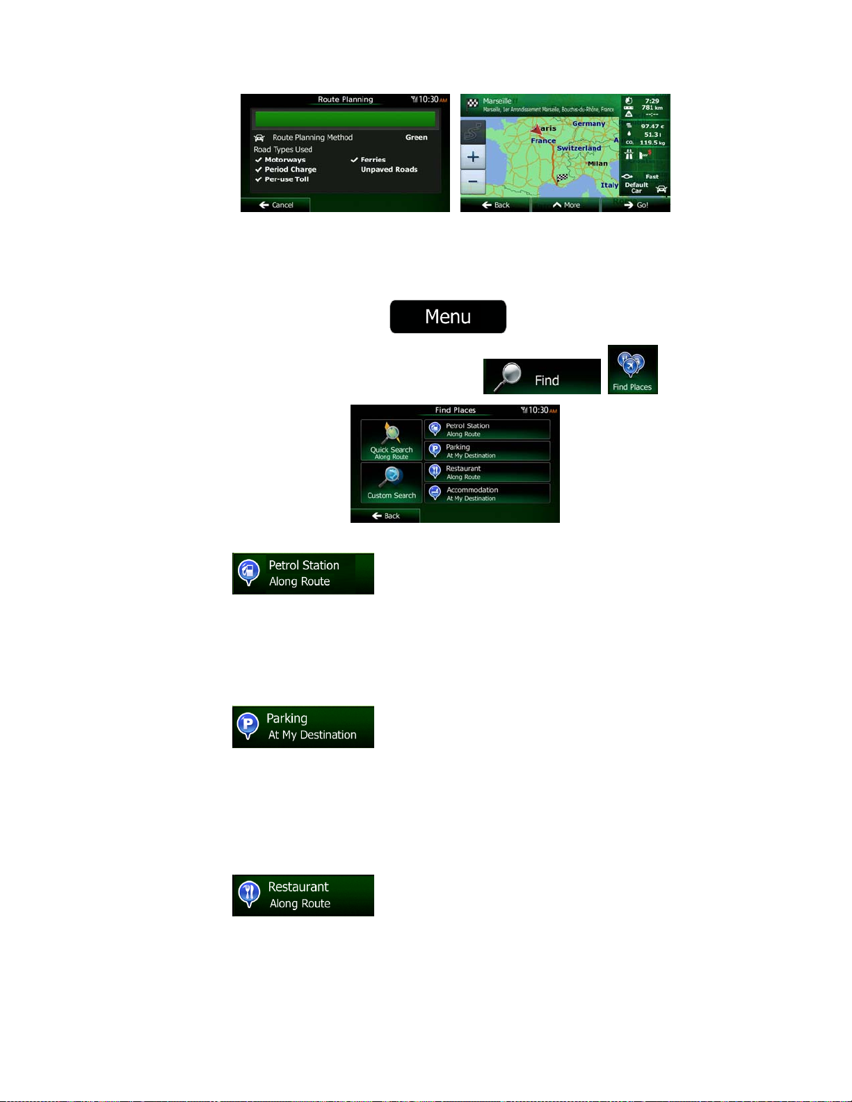
2.2.5 Quick menu
The Quick menu is a selection of controls and functions that are frequently needed during
navigation. It can be opened directly from the Map screen by tapping
The menu will close after a few seconds of inactivity or if you tap
Most of these functions are shortcuts. They are accessible from the menu system.
.
.
NX503E English 21
Page 22

There are more functions available than the number of buttons in the menu. In Settings, you
can choose the function of each button (page 88). The following options are available:
Button Description Shortcut for
This function lets you search for a Place along your route
or around your current location if there is no route
calculated.
Find / Find Places /
Quick Search (page
43)
This button opens the list of your Favourite destinations.
This button ope ns the Histo ry list. Yo u can select on e of
your previous destinations.
This button opens the route editing function.
This button opens the route related settings.
This button opens the map related settings.
This button opens a special screen with information
about the current position and a button to search for
nearby emergency or roadside assistance. For details,
see the next chapter.
Find / Favouri t e (page
55)
Find / History (page
57)
My Route / Edit Route
More / Settings /
Route Settings (page
89)
More / Settings / Map
Settings (page 93)
Tap the Current
Street field on the
Map screen
This button cancels the route and stops navigation. The
button is replaced with the next one if waypoints are
given.
This button skips the next waypoint from the route.
This button opens a 2D map scaled and positioned to
show the entire route.
This button opens the Visual Guidance settings screen.
22 NX503E English
My Route / Cancel
Route (page 66)
My Route / Overview
(page 62)
More / Settings /
Visual Guidance
(page 95)
Page 23

This button opens the Traffic Summary screen.
This button lets you bypass parts of the recommended
route.
This button opens the Trip Monitor screen where you can
manage your previously saved trip logs and track logs.
This button opens the list of manoeuvres (the itinerary).
With this function you can save the active route for later
use.
With this func tion y ou can repl ace t he acti ve route with a
previously saved route.
Tap the Traffic icon in
the Navigation Menu
or on the Map screen
My Route /
Avoidances
More / Trip Monitor
(page 84)
Tap the top of the
Map screen during
navigation.
My Route / More /
Save Route
My Route / More /
Load Route
With this function you can search for Places of Interest in
various different ways.
This button opens the Map screen and starts simulating
the active route.
This button opens the GPS Information screen with
satellite position and signal strength information.
This button offers your Home location as a destination.
This button opens the parameters of the selected Vehicle
profile.
Find / Find Places
(page 43)
My Route / More /
Simulate Navigation
(page 74)
Tap the top of the
Map screen when
there is no GPS
reception
More / Settings /
Route (page 89)
NX503E English 23
Page 24

2.2.6 Checking the details of the current position (Where Am I?)
This screen contains information about the current position (or about the last known position if
GPS reception is not available) and a button to search for useful Places nearby.
.
You can access this screen from the map in one of the following ways:
If the current street is displayed below the Vehimarker (the current position on the
map), tap it to open the Where Am I? screen.
Open the Quick menu and tap the
Information on this screen:
In the middle of the screen you can see whether the position is current, or the time left
Address details (when available) of the current position are also displayed at the
You can also perform some actions on this screen:
, : Latitude and Longitude (coordinate of the current position in WGS84
format).
: Altitude (elevation information coming from the GPS receiver - often inaccurate).
: House number on the left.
: House number on the right.
since it was last updated.
bottom.
button.
Tap
You can also search for assistance near your current position. Tap
open a new screen for the Quick search:
24 NX503E English
to save the current position as a Favourite destination.
to
Page 25

The followi ng services can be searched around the current position or the last known position:
Tap any of the buttons, select a Place from the list, and navigate to it.
: Car repair and roadside assistance services
: Police stations
: Medical and emergency services
: Petrol stations
2.3 Navigation Menu
You can reach all parts of Clarion Mobile Map from the Navigation Menu.
You have the following options:
Tap
a place of interest, a location on the map or one of your Favourite destinations. You
can also look up your recent destinations from the Smart History or enter a coordinate.
Tap
on the map. You can also perform route-related actions such as editing or cancelling
your route, setting a start point for the route, picking route alternatives, avoiding parts
of the route, simulating navigation or adding the destination to your Favourites.
Tap
simulate demo routes or to run some additional applications.
to select your destination by entering an address or selecting
to display the route parameters and the route in its full length
to customise the way the navigation software works, to
NX503E English 25
Page 26

Tap
live map that shows your current position, the recommended route and the surrounding
map area. Tap the button to enlarge the map to the full screen.
to start navigating on the map. The button itself is a miniature
Tap
to open the Traffic Summary screen.
26 NX503E English
Page 27

3 On-road navigation
When first started, Clarion Mobile Map calculates routes using the road network of the high
quality vector maps provided with the product.
You can set up your route in different ways:
If you need a route for immediate navigation, you can select the destination and start
navigating to it right away (normal navigation).
You can also plan a route independently of your current GPS position or even without
GPS reception. To achieve this you need to set a new starting point in My Route / Edit
Route by tapping the flag icon at the current position. This will also turn off the GPS
receiver so that the route is not recalculated when a new position is received.
You can plan routes with multiple destinations. Select the first destination. Then select a
second destination and add it to your route to create a multi-point route. You can add as
many destinations to your route as you like.
You can also use Clarion Mobile Map for off-road navigation. For details, see page.76
3.1 Selecting the destination of a route
Clarion Mobile Map offers you several ways of choosing your destination:
Enter a full address or a part of an address, for example a street name without a house
number or the names of two intersecting streets (page 34).
Enter an address with POSTAL code (page 41). This way you do not need to select the
name of the city/town and the search for street names might be faster as well.
Use a built-in Place of Interest as your destination (page 43).
Select a location on the map with the Find on Map feature (page 55).
Use a previously saved Favourite destination (page 55).
Select a location from the History of previously used destinations (page 57).
Enter the coordinate of the destination (page 5 8).
Use the location where a photo was taken (page 60).
NX503E English 27
Page 28

3.1.1 Combined Search
There are several ways to select the destination of the route. You can find buttons in the
Destination menu that initiate a separate search for addresses, Places, Favourite or recent
destinations. The fastest way to search for any of these is to use the Combined Search. In
this section you can find the full description of how this feature works. The below process
shows how to carry out the search and the following subsections will help you find specific
kinds of results.
1. In the Navigation menu, tap
2. First you see hints on the screen showing how you can use the function. These hints
are only displayed the first time you use this screen.
3. Tap anywhere and the hints disappear. Once you get through this screen to the search
results, the hint will not appear again when you open this window later but you can see
them again if you tap the information button on the right side of the input field.
4. You can see the input field at the top of the screen. Right below that you see the
search area, the city/town around which the search is carried out. The default search
area is the area where you are located. For a local search, skip the next step.
5. (optional) To search in a different area, do as follows:
1. Tap
explains how you can specify the new search centre.
2. Tap anywhere and the hint disappears. If you successfully select a ne w search
area, the hint will not appear again when you open this window later but you can
see it again if you tap the information button on the right side of the input field.
3. Start entering the centre of the new search area using the screen keyboard. You
only need to enter a few letters to get a result. If the new search area is in a
different country, you can narrow the search results if you enter one space and
then a few letters of the country of the search area.
4. The most likely result appe ars below the input field as you enter new letters.
Tap to select this as your new sea rch area. If you cannot see your preferred
. A new screen opens with a new input field. A hint bubble
.
area after a few letters, tap
6. With the proper search area displayed, you can start entering the name, address or
category of the destination you are looking for. The number shown in the
button shows how many results match the entered text. The
background search is carried out while you enter letters so this number may keep on
increasing if you wait a few seconds. Keep on entering new letters while this number is
high.
28 NX503E English
and select one from the list.
Page 29

7. Once the number of results is acceptable after a few seconds of searching, you can
tap
to switch to the result screen.
8. The result screen also opens with hints. Tap anywhere to suppress them. Once you
select a destination, they will not appear again.
9. You see all results in the list, regardless of their type. Addresses, Places, Place
categories, Favourite and recent destinations are mixed within one list.
10. You have the following options:
Tap the result you want to use as your destination. Scroll the list if necessary.
To narrow the search for only one type of result (for example for Places only)
you can tap the related button at the top of the screen. See the next sections for
details.
11. Once the destination is selected, a full screen map appears with the selected point in
the middle. If neces sary, tap the map somewh e r e el se to modify the destinat i on . Th e
Cursor (
) appears at the new location. Tap to confirm the
destinatio n, or tap
to select a different destination.
12. After a short summary of the route parameters, the map appears showing the entire
route. The route is automatically calculated. Tap
route parameters, or tap
and start your journey.
to modify
If you know that you will use this destination frequently, before tapping
to confirm the destination, put it on the list of your
Tip!
Favourites first: tap
give a name f or the new Favourite, and tap
then ,
to save the
location. The map with the destination returns automatically. Now you can start
your journey.
NX503E English 29
Page 30

3.1.1.1 Combined Search - Navigating to a recent destination (History)
To find one of your recent destinations in Combined Search, carry out the search as
described earlier. For the input text you can use either a part of the name or a part of the
address of the recent destination. When you get to the result screen, do as follows:
1. Tap
2. The list is now filtered. What you see is the list of recent destinations with a matching
name or address.
3. Scroll down the list if necessary and then select one of the destinations from the list.
4. Once the destination is selected, a full screen map appears with the selected point in
the middle. If necessary, tap the map somewhere else to modify the destina tion. The
Cursor (
destinatio n, or tap
5. After a short summary of the route parameters, the map appears showing the entire
route. The route is automatically calculated. Tap
route parameters, or tap
at the top of the screen.
) appears at the new location. Tap to confirm the
to select a different destination.
to modify
and start your journey.
Note!
The alternative way to search for a recent destination is to tap the
in the Quick menu or in the Destination menu. The rest of the procedure is
similar to the above.
button
3.1.1.2 Combined Search - Navigating to a Favourite destination
To find one of your Favourite destinations in Combined Search, carry out the search as
described earlier. When you get to the result screen, do as follows:
1. Tap
2. The list is now filtered. What you see is the list of your Favourite destinations with a
matching name.
3. Scroll down the list if necessary and then select one of the destinations from the list.
at the top of the screen.
30 NX503E English
Page 31

4. Once the destination is selected, a full screen map appears with the selected point in
the middle. If necessary, tap the map somewhere else to modify the destina tion. The
Cursor (
destinatio n, or tap
5. After a short summary of the route parameters, the map appears showing the entire
route. The route is automatically calculated. Tap
route parameters, or tap
Note!
The alternative way to search for a Favourite destination is to tap the
button in th e Quick menu or in th e Destination menu. The rest of the procedure
is similar to the above.
) appears at the new location. Tap to confirm the
to select a different destination.
to modify
and start your journey.
3.1.1.3 Combined Search - Navigating to an address
To find an address in Combined Search, carry out the search as described earlier. Use the
name of the street alone or combined with the house number as your input text. When you
get to the result screen, do as follows:
1. Tap
2. The list is now filtered. What you see is the list of matching addresses.
3. Scroll down the list if necessary and then select one of the addresses from the list.
4. Once the destination is selected, a full screen map appears with the selected point in
the middle. If necessary, tap the map somewhere else to modify the destina tion. The
Cursor (
destinatio n, or tap
5. After a short summary of the route parameters, the map appears showing the entire
route. The route is automatically calculated. Tap
route parameters, or tap
at the top of the screen.
) appears at the new location. Tap to confirm the
to select a different destination.
to modify
and start your journey.
NX503E English 31
Page 32

Note!
The alternat i ve way to search for an address is to tap the
Destination menu. Unlike the Combined Search, this alternative search method
is a structured one where you can define the parts of the address separately.
button in the
3.1.1.4 Combined Search - Navigating to a Place of Interest
To find a Place of Interest in Combined Search, carry out the search as described earlier.
Search for a part of its name. When you get to the result screen, do as follows:
1. Tap
2. The list is now filtered. What you see is the list of matching Places ordered by their
distance from your current location.
3. (optional) Should your product contain Places from different data providers, you can
further narrow the list by showing Places from one provider only. Look for the provider
logos at the top of the screen. Tap one of them to see Places from that provider only.
4. Scroll down the list if necessary and then select one of the Places from the list.
5. Once the destination is selected, a full screen map appears with the selected point in
the middle. If necessary, tap the map somewhere else to modify the destina tion. The
at the top of the screen.
Cursor (
destinatio n, or tap
6. After a short summary of the route parameters, the map appears showing the entire
route. The route is automatically calculated. Tap
route parameters, or tap
32 NX503E English
) appears at the new location. Tap to confirm the
to select a different destination.
to modify
and start your journey.
Page 33

Note!
The alternative way to search for a Place is to tap the
menu or the
different from the Combined Search. The first one is also a name search but if
there is a route planned, it will not be carried out around your current location
but along the route. The Place search in the Destination menu is a complex
Place search with several options including category search or search around
the destination of the current route.
button in the Destination menu. These alternatives are
button in the Quick
3.1.1.5 Combined Search - Navigating to a Place of Interest by its category
To find a Place of Interest in Combined Search by giving its category only, carry out the
search as described earlier. Search for a part of the category name. When you get to the
result screen, do as follows:
1. The list is ordered with Place categories at the beginning but if you want, you can filter
the list to contain Place categories only. Tap
list.
2. Scroll the list and select one of the categories. You get the list of Places in that
category ordered by their distance from your current position. If the selected category
contains subcategories, you will see all Places in that category mixed into one list.
3. (optional) Should your product contain Places from different data providers, you can
further narrow the list by showing Places from one provider only. Look for the provider
logos at the top of the screen. Tap one of them to see Places from that provider only.
at the top of the screen to filter the
4. Scroll down the list if necessary and then select one of the Places from the list.
5. Once the destination is selected, a full screen map appears with the selected point in
the middle. If necessary, tap the map somewhere else to modify the destina tion. The
Cursor (
destinatio n, or tap
) appears at the new location. Tap to confirm the
to select a different destination.
NX503E English 33
Page 34

6. After a short summary of the route parameters, the map appears showing the entire
route. The route is automatically calculated. Tap
route parameters, or tap
Note!
The alternative way to search for a Place category is to tap the
the Destination menu and then tap
Combined Search. When you search for a Place category here, you will go
through the whole Place category tree. When you select a category, the list of
its subcategories opens.
and start your journey.
. This alternative is different from the
to modify
button in
3.1.2 Entering an address or a part of the address
If you know at least a part of the address, it is the quickest way to select the destination of the
route.
Using the same screen, you can find an address by entering:
the exact address, including house number
the centre of a city/town
an intersection
the midpoint of a street
any of the above, starting the search with the postal code (page 41 )
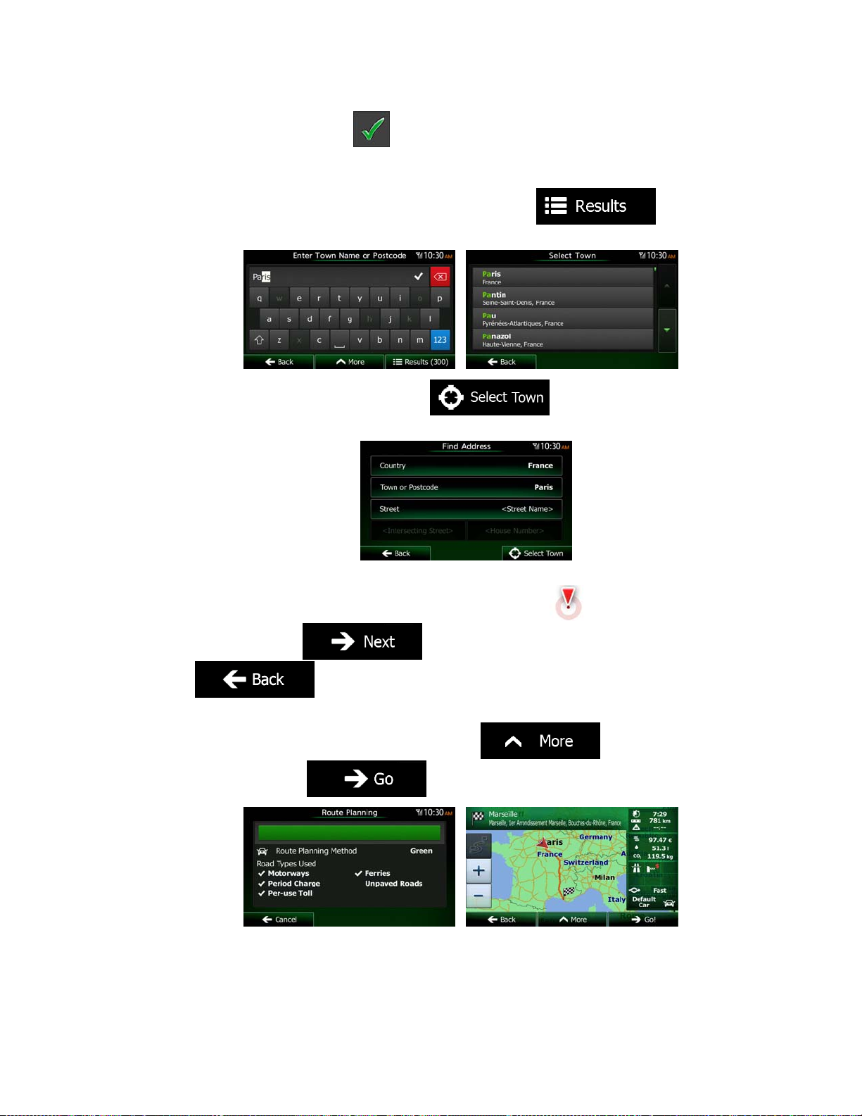
3.1.2.1 Entering an address
To enter an address as the destination, do as follows:
1. If you are on the Map screen, tap
2. In the Navigation Menu, tap the following buttons:
3. By default, Clarion Mobile Map proposes the country and city/town where you are. If
needed, tap
keyboard, and select one country from the list of results.
, enter the first few letters of the country name on the
to return to the Navigation Menu.
, .
34 NX503E English
Page 35

4. If needed, select a new city/town:
a. Tap
.
b. Start entering the name of the city/town on the keyboard.
c. Find the city/town you need:
The most likely city/town name is always shown in the input field. To
accept it, tap
.
If the desired name does not show up, the names that match the string
appear in a list after entering a couple of characters (to open the list of
results before it appears automatically, tap
the city/town from the list.
5. Enter the street name:
). Select
a. Tap
.
b. Start entering the street name on the keyboard.
c. Find the street yo u need:
The most likely street name is always shown in the input field. To accept
it, tap
.
If the desired name does not show up, the names that match the string
appear in a list after entering a couple of characters (to open the list of
results before it appears automatically, tap
). Select
the street from the list.
NX503E English 35
Page 36

6. Enter the house number:
r
a. Tap
b. Enter the house number on the keyboard. (To enter letters, tap
c. Tap
.
).
to finish entering the address. (If the entered house
number cannot be found, the midpoint of the street is selected as the
destination.)
7. A full screen map appears with the selected point in the middle. If necessary, tap the
map somewhere else to modify the destination. The Cursor (
new location . Tap
to confirm the destination, or tap
) appears at the
to select a different destination.
8. After a short summary of the route parameters, the map appears showing the entire
route. The route is automatically calculated. Tap
parameters, or tap
and start your journey.
Tip!
If you know that you will use this destination frequently, before tapping
to confirm the destination, put it on the list of your
Favourites first: tap
name for the new Favourite, and tap
The map with the destination returns automatically. Now you can start you
journey.
to modify route
then , give a
to save the location.
36 NX503E English
Page 37

3.1.2.2 Entering the midpoint of a street as the destination
You can navigate to the midpoint of a street if the house number is not available:
1. If you are on the Map screen, tap
2. In the Navigation Menu, tap the following buttons:
3. If necessary, modify the country and city/town as described earlier (page 34).
4. Enter the street name:
a. Tap
b. Start entering the street name on the keyboard.
c. Find the street yo u need:
The most likely street name is always shown in the input field. To accept
it, tap
If the desired name does not show up, the names that match the string
appear in a list after entering a couple of characters (to open the list of
results before it appears automatically, tap
the street from the list.
.
.
to return to the Navigation Menu.
, .
). Select
5. Instead of entering the hou se number, tap
street is selected as the destination.
6. A full screen map appears with the selected point in the middle. If necessary, tap the
map somewhere else to modify the destination. The Cursor (
new location . Tap
to select a different destination.
to confirm the destination, or tap
. The midpoint of the
) appears at the
NX503E English 37
Page 38

7. After a short summary of the route parameters, the map appears showing the entire
route. The route is automatically calculated. Tap
parameters, or tap
and start your journey.
to modify route
3.1.2.3 Selecting an intersection as the destination
To enter an address as the destination, do as follows:
1. If you are on the Map screen, tap
2. In the Navigation Menu, tap the following buttons:
3. If necessary, modify the country and city/town as described earlier (page 34).
4. Enter the street name:
to return to the Navigation Menu.
, .
a. Tap
b. Start entering the street name on the keyboard.
c. Find the street yo u need:
The most likely street name is always shown in the input field. To accept
it, tap
If the desired name does not show up, the names that match the string
appear in a list after entering a couple of characters (to open the list of
results before it appears automatically, tap
the street from the list.
5. Enter the intersecting street name:
1. Tap
.
.
.
). Select
If only a few intersecting streets exist, their list appears immediately.
38 NX503E English
Page 39

In case of a longer street, the keyboard screen appears. Start entering
the name of the intersecting street on the keyboard. As soon as the street
names that m atch the ent ered string c an be shown on one screen, their
list appears automatically. Select from the list.
6. A full screen map appears with the selected point in the middle. If necessary, tap the
map somewhere else to modify the destination. The Cursor (
new location . Tap
to select a different destination.
7. After a short summary of the route parameters, the map appears showing the entire
route. The route is automatically calculated. Tap
parameters, or tap
to confirm the destination, or tap
and start your journey.
) appears at the
to modify route
3.1.2.4 Selecting a city/town centre as the destination
The city/town centre is not the geometric centre of the city/town but an arbitrary point the map
creators have chosen. In towns and villages, it is usually the most important intersection; in
larger cities, it is one of the important intersections.
1. If you are on the Map screen, tap
2. In the Navigation Menu, tap the following buttons:
3. If necessary, modify the country as described earlier (page 34).
4. Select the destination city/town:
a. Tap
b. Start entering the name of the city/town on the keyboard.
c. Find the city/town you need:
.
to return to the Navigation Menu.
, .
NX503E English 39
Page 40
The most likely city/town name is always shown in the input field. To
accept it, tap
.
If the desired name does not show up, the names that match the string
appear in a list after entering a couple of characters (to open the list of
results before it appears automatically, tap
the city/town from the list.
5. Instead of entering the street name, tap
the displayed city/town becomes the destination of the route.
). Select
. This way the centre of
6. A full screen map appears with the selected point in the middle. If necessary, tap the
map somewhere else to modify the destination. The Cursor (
new location . Tap
to confirm the destination, or tap
) appears at the
to select a different destination.
7. After a short summary of the route parameters, the map appears showing the entire
route. The route is automatically calculated. Tap
parameters, or tap
and start your journey.
to modify route
40 NX503E English
Page 41

3.1.2.5 Entering an address with a postal code
All of the above address searching possibilities can be performed with entering the postal
code instead of the city/town name. Find below an example with a full address:
1. If you are on the Map screen, tap
2. In the Navigation Menu, tap the following buttons:
3. If necessary, modify the country as described earlier (page 34).
4. Enter a new city/town using its postal code:
a. Tap
b. Tap
c. Start entering the postal code.
d. Find the city/town you need:
The most likely postal code is always shown in the input field. To accept
If the desired number does not show up, open the list of results by
to open the numeric keypad.
it, tap
tapping
.
.
. Select the postal code from the list.
to return to the Navigation Menu.
, .
5. Enter the street name:
a. Tap
b. Start entering the street name on the keyboard.
c. Find the street yo u need:
The most likely street name is always shown in the input field. To accept
it, tap
If the desired name does not show up, the names that match the string
appear in a list after entering a couple of characters (to open the list of
results before it appears automatically, tap
the street from the list.
.
.
). Select
NX503E English 41
Page 42

6. Enter the house number:
a. Tap
b. Enter the house number on the keyboard. (To enter letters, tap
c. Tap
.
).
to finish entering the address. (If the entered house
number cannot be found, the midpoint of the street is selected as the
destination.)
7. A full screen map appears with the selected point in the middle. If necessary, tap the
map somewhere else to modify the destination. The Cursor (
new location . Tap
to confirm the destination, or tap
) appears at the
to select a different destination.
8. After a short summary of the route parameters, the map appears showing the entire
route. The route is automatically calculated. Tap
parameters, or tap
42 NX503E English
to modify route
and start your journey.
Page 43

3.1.2.6 Tips on entering addresses quickly
When you are entering the name of a city/town or a street:
Only those l etters are offered on the keyboard that appear in possible search
results. A ll other characters are greyed out.
As you are typing, the most likely result is always displayed in the input field. If
the guess is cor r ect, tap
After entering a couple of letters, tap
contain the specified letters.
You can speed up finding an intersection:
Search first for the street with a less common or less usual name; fewer letters
are enough to find it.
If one of the streets is shorter, search for that one first. You can then find the
second one faster.
You can search for both the type and the name of a road. If the same word appears in
several names, for example in the name of streets, roads and avenues, you can obtain
the result faster if you enter the first letter of the street type: For example, enter 'PI A' to
obtain Pine Avenue and skip all Pine Streets and Pickwick Roads.
You can also search in postal codes. As postal codes consist of only a few characters,
this is usually faster than entering the name of the city/town.
to select it.
to list the items that
3.1.3 Selecting the destination from the Places of Interest
You can select your destination from the Places of Interest included with Clarion Mobile Map.
Using the same screen, you can find a Place in different ways:
with the Quick search feature, you can quickly find a nearby Place by its name
with the Preset search feature, you can find frequently searched types of Places with
only a few screen taps
you can search for a Place by its category
you can search for a Place by its name
In addition, you can search for special services from the 'Where Am I?' screen.
3.1.3.1 Quick search for a Place of Interest
The Quick search feature lets you quickly find a Place by its name. The search is always
carried out
along the recommended route if it exists or
around your current location if there is no destination given.
NX503E English 43
Page 44

1. Start the Quick search function:
If you are on the Map screen, tap
and then tap .
If you are in the Navigation Menu, tap
tap
.
2. Using the keyboard, start entering the name of the Place.
3. After entering a few letters, tap
to open the list of Places with
names containing the entered character sequen ce.
, and then
4. (optional) The Places in the list are ordered by the length of the necessary detour
(when navigating a route) or by their distance from the current position (when no
destination is given). If you need to reorder the list, tap
.
5. Browse the list if necessary and tap one of the list items. A full screen map appears
with the selected point in the middle. The name and ad dress of the Place i s displayed
at the top of the screen.
6. (optional) Tap
to see the details of the selected Place. Tap
to return to the map.
7. If necessary, tap the map somewhere else to modify the destination. The Cursor
(
) appears at the new location. Tap to confirm the
destination, or tap
to select a different destination.
8. After a short summary of the route parameters, the map appears showing the entire
route. The route is automatically calculated. Tap
parameters, or tap
and start your journey.
to modify route
44 NX503E English
Page 45
3.1.3.2 Searching for a Place of Interest using preset categories
The Preset search feature lets you quickly find the most frequently selected types of Places.
1. If you are on the Map screen, tap
2. In the Navigation Menu, tap the following buttons:
3. The preset search categories appear:
If an active route exists, petrol stations are searched along the route.
If t here is no act ive rout e (destina tion is not selec ted), the y are searc hed
around the current position.
If the current position is not available either (no GPS signal), they are
searched around the last known position.
:
to return to the Navigation Menu.
, .
If an active route exists, parking lots are searched around the destination
of the route.
If t here is no act ive rout e (destina tion is not selec ted), the y are searc hed
around the current position.
If the current position is not available either (no GPS signal), they are
searched around the last known position.
If an active route exists, restaurants are searched along the route.
If t here is no act ive rout e (destina tion is not selec ted), the y are searc hed
around the current position.
:
:
NX503E English 45
Page 46

If the current position is not available either (no GPS signal), they are
searched around the last known position.
:
If an active route exists, accommodation is searched around the
destination of the route.
If t here is no act ive rout e (destina tion is not selec ted), the y are searc hed
around the current position.
If the current position is not available either (no GPS signal), they are
searched around the last known position.
4. Tap any of the quick search buttons to get an instant list of Places.
5. (optional) The Places in the list are ordered by their distance from the current or last
known position, from the destination or by the lengt h of the necessary detour. If you
need to reorder the list, tap
.
6. Browse the list if necessary and tap one of the list items. A full screen map appears
with the selected point in the middle. The name and ad dress of the Place i s displayed
at the top of the screen.
7. (optional) Tap
to see the details of the selected Place. Tap
to return to the map.
8. If necessary, tap the map somewhere else to modify the destination. The Cursor
) appears at the new location. Tap to confirm the
(
destinatio n, or tap
to select a different destination.
9. After a short summary of the route parameters, the map appears showing the entire
route. The route is automatically calculated. Tap
parameters, or tap
and start your journey.
to modify route
46 NX503E English
Page 47

3.1.3.3 Searching for a Place of Interest by category
You can search for Places of Interest by their categories and subcategories.
1. If you are on the Map screen, tap
2. In the Navigation Menu, tap the following buttons:
3. Tap
4. Select the area around which the Place should be searched for:
Tap
Tap
Tap
Tap
.
to search around the current position or if it is not
available, around the last know position. (The result list will be ordered by the
distance from this position.)
to search for a place within a selected city/town. (The
result list will be ordered by the distance from the centre of the selected
city/town.)
to search for a place around the destination of the
active route. (The result list will be ordered by the distance from the destination.)
to search along the active route, and not around a
given point. This is useful when you search for a later stopover that results in a
minimal detour only, such as searching for upcoming petrol stations or
restaurants. (The result list will be ordered by the length of the necessary
detour.)
to return to the Navigation Menu.
, .
5. (optional) If you have selected
6. Select one of the main Place categories (e.g. Accommodation) or tap
to list all Places around the selected location or along the route.
, select the city/town to search in.
NX503E English 47
Page 48

7. Select one of the Place subcategories (e.g. Hotel or Motel) or tap
to list all Places in the selected main category around the selected location or along the
route.
8. Sometimes the list of brands in the selected Place subcategory appears. Select one
brand or tap
to list all Places in the selected subcategory around
the selected location or along the route.
9. Finally, the results appear in a list.
10. (optional) The Places in the list are ordered by their distance from the current or last
known position, from the selected city/town, from the destination or by the length of the
necessary detour. If you need to reorder the list, tap
.
11. Browse the list if necessary and tap one of the list items. A full screen map appears
with the selected point in the middle. The name and ad dress of the Place i s displayed
at the top of the screen.
12. (optional) Tap
to see the details of the selected Place. Tap
to return to the map.
48 NX503E English
Page 49

13. If necessary, tap the map somewhere else to modify the destination. The Cursor
) appears at the new location. Tap to confirm the
(
destinatio n, or tap
14. After a short summary of the route parameters, the map appears showing the entire
route. The route is automatically calculated. Tap
parameters, or tap
to select a different destination.
to modify route
and start your journey.
3.1.3.4 Searching for a Place of Interest by name
You can search for Places of Interest by their names. You can search around different
locations or along your route in the whole Place database or in one Place category or
subcategory only.
1. If you are on the Map screen, tap
to return to the Navigation Menu.
2. In the Navigation Menu, tap the following buttons:
3. Tap
4. Select the area around which the Place should be searched for:
Tap
Tap
Tap
.
to search around the current position or if it is not
available, around the last know position. (The result list will be ordered by the
distance from this position.)
to search for a place within a selected city/town. (The
result list will be ordered by the distance from the centre of the selected
city/town.)
to search for a place around the destination of the
active route. (The result list will be ordered by the distance from the destination.)
, .
NX503E English 49
Page 50

Tap
to search along the active route, and not around a
given point. This is useful when you search for a later stopover that results in a
minimal detour only, such as searching for upcoming petrol stations or
restaurants. (The result list will be ordered by the length of the necessary
detour.)
5. (optional) If you have selected
, select the city/town to search in.
6. Select one of the main Place categories (e.g. Accommodation) to search in or tap
to search among all Places.
7. Select one of the Place subcategories (e.g. Hotel or Motel) to search in or tap
to search in the selected Place category.
50 NX503E English
Page 51

8. Tap
if you have not done it before.
9. Using the keyboard, start entering the name of the Place.
10. After entering a few letters, tap
to open the list of Places with
names containing the entered character sequen ce.
11. (optional) The Places in the list are ordered by their distance from the current or last
known position, from the selected city/town, from the destination or by the length of the
necessary detour. If you need to reorder the list, tap
.
12. Browse the list if necessary and tap one of the list items. A full screen map appears
with the selected point in the middle. The name and ad dress of the Place i s displayed
at the top of the screen.
13. (optional) Tap
to see the details of the selected Place. Tap
to return to the map.
14. If necessary, tap the map somewhere else to modify the destination. The Cursor
(
) appears at the new location. Tap to confirm the
destinatio n, or tap
to select a different destination.
NX503E English 51
Page 52

15. After a short summary of the route parameters, the map appears showing the entire
route. The route is automatically calculated. Tap
parameters, or tap
and start your journey.
to modify route
3.1.3.5 Searching for a Place of Interest by its Phone Number
You can search for Places of Interest by their Phone Number:
1. If you are on the Map screen, tap
2. In the Navigation Menu, tap the following buttons:
3. The numeric keyboard appears. Enter the phone number you are looking for or a part
of it.
to return to the Navigation Menu.
, .
4. Tap
5. The list of Places with the entered sequence in their phone number appears.
6. (optional) The Places in the list are ordered by their distance from the current or last
known position, from the selected city/town, from the destination or by the length of the
necessary detour. If you need to reorder the list, tap
7. Browse the list if necessary and tap one of the list items. A full screen map appears
with the selected point in the middle. The name and ad dress of the Place i s displayed
at the top of the screen.
8. (optional) Tap
to return to the map.
.
to see the details of the selected Place. Tap
.
52 NX503E English
Page 53
9. If necessary, tap the map somewhere else to modify the destination. The Cursor
) appears at the new location. Tap to confirm the
(
destinatio n, or tap
10. After a short summary of the route parameters, the map appears showing the entire
route. The route is automatically calculated. Tap
parameters, or tap
to select a different destination.
to modify route
and start your journey.
3.1.3.6 Selecting nearby assistance from 'Where Am I?'
You can quickly search for nearby assistance from the 'Where Am I?' screen.
1. On the Map screen, tap
to open the Quick menu.
2. Tap
3. Preset search categories appear, all for searching around the current position (or
around the last known position if the current position is not available):
, and then .
: Car repair and roadside assistance services
: Medical and emergency services
NX503E English 53
Page 54

: Police stations
: Petrol stations
4. Tap any of the quick search buttons to get an instant list of that type of Places.
5. (optional) The Places in the list are ordered by their distance from the current or last
known position, from the selected city/town, from the destination or by the length of the
necessary detour. If you need to reorder the list, tap
.
6. Browse the list if necessary and tap one of the list items. A full screen map appears
with the selected point in the middle. The name and ad dress of the Place i s displayed
at the top of the screen.
7. (optional) Tap
to see the details of the selected Place. Tap
to return to the map.
8. If necessary, tap the map somewhere else to modify the destination. The Cursor
(
) appears at the new location. Tap to confirm the
destinatio n, or tap
to select a different destination.
9. After a short summary of the route parameters, the map appears showing the entire
route. The route is automatically calculated. Tap
parameters, or tap
and start your journey.
to modify route
54 NX503E English
Page 55

3.1.4 Selecting a map location as the destination
1. If you are on the Map screen, tap to return to the Navigation Menu.
2. In the Navigation Menu, tap the following buttons:
3. Locate your destination on the map: move and scale the map as needed.
4. Tap the location that you want to select as your destination. The Cursor (
appears.
5. Tap
6. After a short summary of the route parameters, the map appears showing the entire
route. The route is automatically calculated. Tap
parameters, or tap
to select the Cursor as the destination.
and start your journey.
, .
)
to modify route
3.1.5 Selecting the destination from your Favourites
You can select a location that you have already saved as a Favourite to be your destin ation.
Adding a location to the list of Favourite destinations is described on page 71.
1. Access the list of Favourites:
If you are on the Map screen, tap
If you are in the Navigation Menu, tap
to open the Quick menu.
.
NX503E English 55
Page 56

2. Tap
. The list of Favourite destinatio ns is displayed.
3. Tap the Favourite that you want to set as your destination. If necessary, browse down
to see more of the list or tap
name of the Favourite destination.
4. A full screen map appears with the selected point in the middle. If necessary, tap the
map somewhere else to modify the destination. The Cursor (
new location . Tap
to select a different destination.
5. After a short summary of the route parameters, the map appears showing the entire
route. The route is automatically calculated. Tap
parameters, or tap
to confirm the destination, or tap
and start your journey.
and enter a few letters from the
) appears at the
to modify route
3.1.6 Selecting your Home location
To navigate to your Home location, first you need to save it. Seach for your address or
browse the map and when the Cursor is at the desired location, tap
select
Now that the Home location is set, you can quickly navigate to it:
1. To select the Home location, do one of the following:
If you are on the Map screen, tap
be added to the Quick menu in Settings - page 88).
56 NX503E English
.
and then tap (this button can
and
Page 57

If you are in the Navigation Menu, tap
.
2. A full screen map appears with the selected point in the middle. If necessary, tap the
map somewhere else to modify the destination. The Cursor (
new location . Tap
to select a different destination.
3. After a short summary of the route parameters, the map appears showing the entire
route. The route is automatically calculated. Tap
parameters, or tap
to confirm the destination, or tap
and start your journey.
and then tap
) appears at the
to modify route
3.1.7 Selecting a recent destination from the History
The destinations that you have set earlier appear in the History.
1. Access the History:
If you are on the Map screen, tap
If you are in the Navigation Menu, tap
.
and then tap .
and then tap
NX503E English 57
Page 58

2. The list of recent destinations appears. Smart History promotes three destinations to
the first page based on your previous routes (most likely destinations). The rest of the
destinations are ordered by time they were last selected. If necessary, scroll the list to
see earlier destinations.
3. Select a destination from the list.
4. A full screen map appears with the selected point in the middle. If necessary, tap the
map somewhere else to modify the destination. The Cursor (
new location . Tap
to select a different destination.
5. After a short summary of the route parameters, the map appears showing the entire
route. The route is automatically calculated. Tap
parameters, or tap
to confirm the destination, or tap
and start your journey.
) appears at the
to modify route
3.1.8 Entering the Coordinate of the destination
You can also select a destination by entering its coordinate. Do as follows:
1. If you are on the Map screen, tap
2. In the Navigation Menu, tap
3. Open the
58 NX503E English
menu and tap .
to return to the Navigation Menu.
.
Page 59

4. You can enter the latitude and longitude values in any of the following formats: decimal
degrees; degrees and decimal minutes; or degrees, minutes and decimal seconds.
5. (optional) If necessary, tap
then and enter
the coordinate in UTM format.
6. When finished, tap
.
7. A full screen map appears with the selected point in the middle. If necessary, tap the
map somewhere else to modify the destination. The Cursor (
new location . Tap
to confirm the destination, or tap
) appears at the
to select a different destination.
8. After a short summary of the route parameters, the map appears showing the entire
route. The route is automatically calculated. Tap
parameters, or tap
to modify route
and start your journey.
NX503E English 59
Page 60

3.1.9 Navigate to a location stored in a photo
f
You can also set the location stored in a photo as your destination. Do as follows:
1. If you are on the Map screen, tap
2. In the Navigation Menu, tap
3. Open the
4. The list of photos stored in the device appears. Select one photo from the list.
5. A full screen map appears with the selected point in the middle. If necessary, tap the
map somewhere else to modify the destination. The Cursor (
new location . Tap
to select a different destination.
6. After a short summary of the route parameters, the map appears showing the entire
route. The route is automatically calculated. Tap
parameters, or tap
menu and tap .
to confirm the destination, or tap
and start your journey.
to return to the Navigation Menu.
.
) appears at the
to modify route
Note!
Only geotagged JPG files contain location information. That is why these kind o
files can only be used in navigation. Other picture files do not appear in the list.
Files must be l oc at ed on a n i ns er te d SD c ard o r U SB pen dr iv e, ei t her i n t he r o ot
folder or in a "pictures" folder.
60 NX503E English
Page 61

3.1.10 Building a route from the list of destinations (Create Route)
You can also build your route destination by destination from the My Route menu.
1. If you are on the Map screen, tap
2. In the Navigation Menu, tap
3. Tap
4. There is only one line in the list of route points, the start point of the route, normally the
current GPS position.
5. Tap
6. The Destination menu appears and you can select the destination of the route the
same way as described in the previous sections.
to select the destination.
.
to return to the Navigation Menu.
.
7. When the new destination is selected, the list returns.
8. To add more destinations, tap
the list, and repeat the above procedure.
where you want to insert the new route point in
NX503E English 61
Page 62

3.2 Viewing the entire route on the map
It is easy to get a map overview of the active route. Do as follows:
1. If you are on the Map screen, tap
2. In the Navigation Menu, tap
3. Tap
together with additional information and controls.
. The active route is displayed in its full length on the map
to return to the Navigation Menu.
.
3.3 Checking route parameters and accessing route related functions
You can check different parameters of the route recommended by Clarion Mobile Map.
1. If you are on the Map screen, tap
to return to the Navigation Menu.
2. In the Navigation Menu, tap
3. The following pieces of information are displayed:
x The name and/or address of the destination.
x Warning icons (if any). They provide extra information about your route (e.g.
unpaved roads or toll roads to be taken).
x The total time of the route.
x The total length of the route.
x Estimated delay calculated from traffic events on your route.
x The symbol of the vehicle type used in route calculation.
x The route planning method (e.g. Fast).
.
62 NX503E English
Page 63

4. You have the following options on this screen (for detailed instructions on how to use
them, see the next chapter):
Tap
change their sequence. You can also set a route start point other than your
current location. This can be useful to plan and save a future trip.
Tap
Tap
Tap
Tap
route alternatives, changing route parameters, simulating the route, saving the
active route or loading a previously saved route.
Tap
to edit the route: to add or remove destinations or
to display the entire route on the map.
to bypass a part of the route.
to delete the active route.
to open a list with more options like selecting from
to return to the Navigation Menu.
3.4 Modifying the route
When navigation is already started, there are several ways to modify the active route. The
following sections show some of those options.
3.4.1 Selecting a new destination when already having a route: New Route,
Waypoint or Final Destination
If you already have a recommended route and you select a new destination as described in
the above sections, the application will ask you whether to start a new route, add a new
waypoint (intermediate destination) to the route or append the newly selected destination at
the end of the current route.
Tap
destination and waypoint(s) are deleted.
to plan a new route to the newly selected location. The previous
NX503E English 63
Page 64

Tap
route. The other destinations of the route remain intact. Note: the new waypoint is
placed among destinations to keep the route optimal. To decide where a waypoint to
appear, use the Edit Route feature.
to add the newly selected location as an intermediate destination to your
Tap
other destinations of the route remain intact. Th e previous final destination is now th e
last waypoint.
to append the newly selected destination at the end of the route. The
3.4.2 Setting a new starting position for the route
For normal navigation, all routes are planned from the current position. In order to check
future routes, simulate them or see their length in time and distance, you can turn off the GPS
receiver. Then you can set the starting point of the route to a different location than the
current GPS position.
1. If you are on the Map screen, tap
2. In the Navigation Menu, tap
3. If you already have a route, tap
tap
.
to return to the Navigation Menu.
.
. If you are starting a new route,
64 NX503E English
Page 65

4. The first line is the start of the route, normally the current GPS position. Tap
confirm your action at the warning message.
5. The Destination menu appears and you can select the start point of the route the same
way you select a destination.
6. When the new start point is set, tap
7. The map returns with a transparent Vehimarker (showing that there is no GPS
reception). If an active route already existed, it is now recalculated starting from the
selected location.
.
and
8. To return to normal navigation, tap
.
3.4.3 Editing the list of destinations (Edit Route)
You can edit the route by modifying the list of destinations. You can add or remove
destinations, modify the start position or reorder the list.
1. If you are on the Map screen, tap
2. In the Navigation Menu, tap
to return to the Navigation Menu.
.
NX503E English 65
Page 66

3. Tap
4. You have the following options:
Tap
Tap
Tap
Tap
let the application optimis e the route for you.
to add a new destination.
to modify the start point of the route.
.
to delete a dest i n at i o n.
to reorder the list. You can do it manually or you can
3.4.4 Pausing the active route
You do not need to pause t he active route: whe n you star t driving again, Cl arion Mobi le Map
restarts the voice instructions from your position.
3.4.5 Cancelling the active route
To cancel the navigated route, do one of the following:
If you are on the Map screen, tap
with waypoints, you need to tap
In the Navigation Menu, tap
The active route is deleted with all its waypoints.
and then tap . (If you have a route
until all waypoi n t s are deleted.)
and then tap ..
66 NX503E English
Page 67

3.4.6 Checking route alternatives when planning the route
You can select from different route alternatives or change the route planning method after you
have selected a new destination. Do as follows:
1. Select a destination as explained earlier, and get to the route confirmation screen.
2. Tap
3. Tap
4. You see the basic details of three route alternatives with the selected route planning
method. Tap any of them to see it on the map.
5. Or if you cannot find a good alternative, tap
routes with different routing methods.
.
.
and scroll down for
6. Select one of the route alternatives and tap
previous screen. Clarion Mobile Map recalculates the route. The orange line now
shows the new recommended route.
to return to the
NX503E English 67
Page 68

3.4.7 Checking route alternatives for an existing route
To recalculate the active route with a different route planning method, you can modify the
Route settings (page 89). There is another way to do this and to compare different route
alternatives with the same route planning method. Do as follows:
1. If you are on the Map screen, tap
2. In the Navigation Menu, tap
3. Tap
4. Tap
5. You see the basic details of three route alternatives with the selected route planning
method. Tap any of them to see it on the map.
.
.
to return to the Navigation Menu.
.
6. Or if you cannot find a good alternative, tap
routes with different routing methods.
68 NX503E English
and scroll down for
Page 69
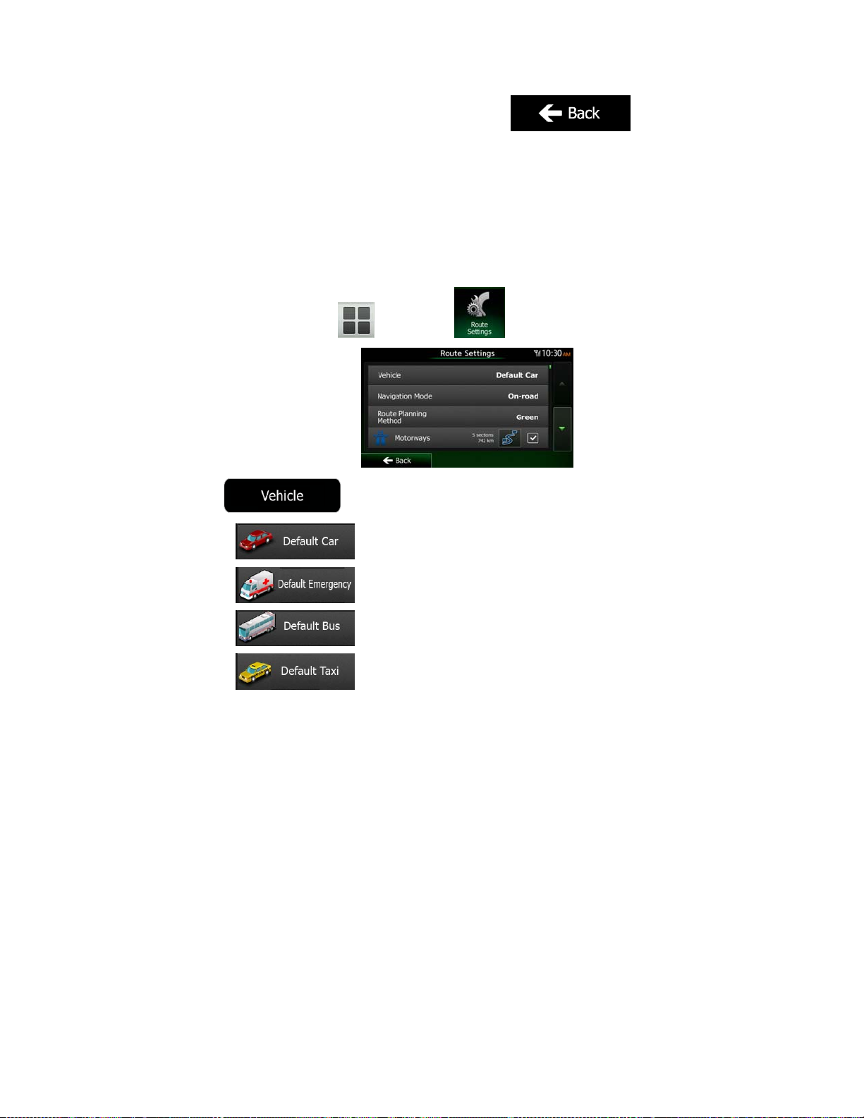
7. Select one of the route alternatives then tap and hold
seconds to return to the Map screen. Clarion Mobile Map recalculates the route. The
orange line now shows the new recommended route.
for a few
3.4.8 Changing the vehicle used in route planning
To recalcul ate the act ive route f or a diffe rent vehi cle, do as f ollows. These chang es can als o
be made in Settings (page 89).
1. On the Map screen, tap
2. Tap
and then tap .
and then tap one of the following:
3. Clarion Mobile Map recalculates the route optimised for the new vehicle type. The
orange line now shows the new recommended route.
NX503E English 69
Page 70

3.4.9 Changing the road types used in route planning
To recalculate the active route with different road type preferences, do as follows. These
changes can also be made in Settings (page 89).
1. On the Map screen, tap
2. Tap any of the listed road types to modify the route. If needed, scroll the list for all road
types. You have the following options (their order depends on the selected vehicle
type):
a slow car or you are towing another vehicle.
pass or vignette to use the road for a longer period of time. They can be
enabled or disabled separately from toll roads.
there is a per-use charge) in the routes by default. If you disable toll roads,
Clarion Mobile Map plans the best toll-free route.
and then tap .
- You might need to avoid motorways when you are driving
- Charge roads are pay roads where you can purchase a
- Clarion Mobile Map includes toll roads (pay roads where
default. However, a map does not necessarily contain information about the
accessibility of temporary ferries. You might also need to pay a fare on ferries.
unpaved roads can be in a bad condition and usually you cannot reach the
speed limit on them.
3. Tap
route. The orange line now shows the new recommended route.
70 NX503E English
- Clarion Mobile Map includes ferries in a planned route by
- Clarion Mobile Map excludes unpaved roads by default:
to confirm the changes. Clarion Mobile Map recalculates the
Page 71

3.5 Saving a location as a Favourite destination
You can add any location to Favourites, the list of frequently used destinations. Planning a
route to one of the Favourite destinations is described on page 55.
1. Select a destination as described before. It can be an address, a Place, any location
on the map, a previously used destination from History, etc.
2. When the full screen map appears with the selected location in the middle, tap
.
3. Tap
4. (optional) Using the keyboard, you can change the name offered for the Favourite. Tap
to enter numbers or symbols.
5. Tap
.
to save the location as a new Favourite destination.
NX503E English 71
Page 72

3.6 Saving a location as an alert point
You can save any map location as an alert point (for example a speed camera or a railway
crossing).
1. Browse the map and select a location. The red Cursor appears there.
2. Tap
3. Scroll down the li s t an d t ap
4. On the newly opened screen, select the type of the alert point, the direction from which
you expect the alert, and (if applicable) the speed limit for this alert point.
5. Tap
.
.
to save the location as a new alert point.
72 NX503E English
Page 73

3.7 Editing an alert point
You can edit a previously saved or uploaded alert point (for example a speed camera or a
railway crossing).
1. Browse the map and select the alert point to edit. The red circle appears around the
alert point .
2. Tap
3. Scroll down the li s t an d t ap
4. On the newly opened screen, modify the type of the alert point, the direction from
which you expect the alert, or (if applicable) the speed limit for this alert point.
5. Tap
.
.
to save the changes to the alert point.
NX503E English 73
Page 74

3.8 Watching the simulation of the route
You can run a simulated navigation that demonstrates the active route. Do as follows:
1. If you are on the Map screen, tap
2. In the Navigation Menu, tap
3. Tap
4. Scroll down the li s t an d t ap
point of the route, and using a realistic speed, it leads you through the whole
recommended route.
.
to return to the Navigation Menu.
.
. The simulation starts from the starting
1. (optional) You have the following controls during the simulation (the control buttons
disappear after a few seconds but you can open them again if you tap the map):
74 NX503E English
: Jump to the next route event (manoeuvre).
: Pause the simulation.
: Jump to the previous route event (manoeuvre).
Page 75

2. Tap
: Tap to increase the speed of the simulation to 4, 8 or 16 times faster.
Now tap again to return to the normal speed.
to stop the simulation.
NX503E English 75
Page 76

4 Off-road navigation
When first started, Clarion Mobile Map calculates routes using the road network of the high
quality vector maps provided with the product. You can switch the application to off-road
mode in Navigation settings in one of the following ways:
From the Main menu, tap
.
From the Map screen, tap
Most of the procedures described for on-road navigation also apply to off-road navigation.
However, there are some that are not available in this navigation mode (for example you
cannot open the itinerary as you have no manoeuvres just route points and straight lines
between them).
, and then .
, , and then
4.1 Selecting the destination of the route
Selecting the start point or a destination (waypoint or final destination) is the same as
described at on-road navigation. The only difference is that route points are linked to form a
route with straight lines regardless of the road network and traffic regulations.
4.2 Navigating in off-road mode
The real difference between the on-road and off-road modes is the navigation itself. When
you are on the Map s creen with an off-road r oute:
your position and heading is not aligned with the nearest road and
there is no turn by turn navigation just a recommended direction.
You see a orange line drawn between your current position and the next destination to reach.
The Turn Preview field in the top left corner shows a compass with your bearing and the
distance of the next destination.
When you reach a waypoint, the orange line will show the direction to the next destination.
(Future legs of the route are shown with orange lines.)
When you reach the final destination, navigation ends.
76 NX503E English
Page 77

5 Reference Guide
On the following pages you will find the description of the different concepts and menu
screens of Clarion Mobile Map.
5.1 Concepts
5.1.1 Smart Zoom
Smart Zoom provides much more than just a usual automatic zoom feature:
While following a route: when approaching a turn, it will zoom in and raise the view
angle to let you easily recognise your manoeuvre at the next junction. If the next turn is
at a distance, it will zoom out and lower the view angle to be flat so you can see the
road in front of you.
While driving without an active route: Smart Zoom will zoom in if you drive slowly
and zoom out when you drive at high speed.
5.1.2 Daytime and night colour themes
Clarion Mobile Map uses different colour themes during the day and during the night for both
the map and the menu screens.
Daytime colours are similar to paper road maps, and the menus are bright.
The night colour themes use dark colours for large objects to keep the average
brightness of the screen low.
Clarion Mobile Map offers different daytime and night colour profiles. It can also switch
automatically between the daytime and the night schemes based on the current time and
GPS position a few minutes before sunrise, when the sky has already turned bright, and a few
minutes after sunset, before it becomes dark.
5.1.3 Tunnel view
When entering a tunnel, the map is replaced with a generic tunnel image so that surface
roads and buildings cannot distract you.
The top-down overview of the tunnel helps you orientate yourself. The remaining distance in
the tunnel is also displayed.
After leaving the tunnel, the original map view returns.
This feature can be turned off in Settings (page 95).
NX503E English 77
Page 78

5.1.4 Route calculation and recalculation
Clarion Mobile Map calculates the route based on your preferences:
Route planning methods:
limit on all roads. Usually the best selection for fast and normal cars.
possible routes. It can be practical for slow vehicles.
consumption data given in Route settings (page 89). Travel cost and CO
emission calculations are estimations only. They cannot take elevations, curves
and traffic conditions into account.
method combines the benefits of Fast and Short: Clarion Mobile Map calculates
as if it were calculating the Fast route, but it takes other roads as well to save
fuel.
manoeuvres. With this option, you can make Clarion Mobile Map to take, for
example, the motorway instead of a series of smaller roads or streets.
Vehicle types:
When creating a new vehicle profile, select one of the below vehicle types. Besides
the below mentioned conditions, dimension, weight and freight hazard restrictions
can also be taken into account when planning a route.
: Gives a quick route if you can travel at or near the speed
: Gives a route that has the smallest total distance of all
: Gives a quick but fuel efficient route based on the fuel
2
: For vehicle types where Green routing is not available, this
: Results in a route with fewer turns and no difficult
Manoeuvre restrictions and directional constraints are taken into account
Roads are used only if access for cars is allowed.
Private roads and resident-only roads are used only if they are inevitable
Walkways are excluded from routes.
All manoeuvres are available in intersections.
Directional constraints are taken into account the way that opposite
A private road is used only if the destination is there.
Walkways are excluded from routes.
78 NX503E English
:
when planning a route.
to reach the destination.
:
direction is al lowed with a low speed.
Page 79

:
Manoeuvre restrictions and directional constraints are taken into account
when planning a route.
Roads are used only if access for buses is allowed.
Private roads, resident-only roads and walkways are excluded from
routes.
:
Manoeuvre restrictions and directional constraints are taken into account
when planning a route.
Roads are used only if access for taxis is allowed.
Private roads, resident-only roads and walkways are excluded from
routes.
:
Manoeuvre restrictions and directional constraints are taken into account
when planning a route.
Roads are used only if access for lorries is all owed.
Private roads, resident-only roads and walkways are excluded from
routes.
U-turns are excluded from routes (turning back on a divided road is not
considered as a U-turn).
Road types used or avoided in route calculation:
Real-time Traffic events are also taken into account and sometimes greatly modify the route.
Clarion Mobile Map automatically recalculates the route if you deviate from the proposed
itinerary or if a newly received Traffic event concerns a part of the recommended route.
For further information about Route settings, see page 89.
NX503E English 79
Page 80

5.1.5 Green routing
Route calculation is not only about finding the quickest or shortest route. For some of the
vehicle typ es, you can also check the fuel co nsumption and CO
route, and you can create cost effective routes with less effect on the environment.
In Route settings, you can edit the parameters of the selected vehicle. Enter the fuel
consumption values and the price of the fuel. You can also select whether you want to see
the difference between your route and the green route even if the selected routing method is
not Green.
emission when planning a
2
After the above parameters are set, select
get a fast but also fuel efficient route. Note that travel cost and CO
as route planning method to
emission calculations are
2
estimations only. They cannot take elevations, turns, curves and traffic conditions into
account. Also, this routing is not meant to give you the "greenest" route of all. It is still
important to travel quickly so the result is a fast route with low fuel consumption and CO
2
emission.
With a vehicle type where green routing is selectable, whichever route planning method is
selected, the Green details are also shown when you confirm the route:
If the selected route planning method is not Green, and you have allowed the application to
show the green alternative, the price, fuel consumption and CO
emission differences
2
between your selected route and the Green route are also shown on this screen:
Tap the field with these details to switch the route to Green immediately.
5.1.6 Road safety cameras and other proximity alert points
There is a special proximity warning for road safety cameras (like speed or red light cameras)
and other proximity alert points (like schools or railroad crossings). These alert points are
preloaded in Clarion Mobile Map. You can download more from www.clarion.naviextras.com
or you can upload points in a specific text file if needed.
You can also add your own alert points or edit the preloaded or uploaded points. See page 72
for details.
The application can warn you when you approach road safety cameras like speed cameras or
dangerous areas like school zones or railroad crossings. You can set up the different alert
types individually in Sound and Warning settings (page 86).
The following alert types are available:
80 NX503E English
Page 81

Audio warning: beeps can be played (natural voice) or the type of the alert can be
announced (TTS) while you are approaching one of these points, and an extra alert
can warn you if you exceed the given speed limit while approaching.
Visual warning: the type of the alert point, its distance and the related speed limit
appear on the Map screen while you are approaching one of these cameras.
For some of the alert points, the enforced or expected speed limit is available. For these
points, the audio alert can be different if you are below or above the given speed limit.
Only when speeding: The audio alert is only played when you exceed the given speed
limit.
When approaching: The audio alert is always played when approaching one of these
alert points. In order to draw your attention, the alert can is different when you exceed
the speed limit.
Note!
The warning for road safety cameras is disabled when you are in a country
where road safety camera warning is prohibited. However, you must ensure on
your own liability that using this feature is legal in the country where you intend
to use it.
5.1.7 Speed limit warning
Maps may contai n information about the speed limits of the road segments. Clarion Mobile
Map is able to warn you if you exceed the current limit. This information may not be available
for your region (ask your local dealer), or may not be fully correct for all roads in the map.
The maximum speed set in the vehicle pr ofile is also used for t his warning. Clarion Mob ile
Map alerts you if you exceed the preset value even if the legal speed limit is higher.
Speed warning can be fine-tuned in Sound and Warning settings (page 86).
You can set the relative speed above which the application initiates the warning.
The following alert types are available:
Audio warning: you receive a verbal warning when you exceed the speed limit with the
given perce ntage.
Visual warning: the current speed limit is shown on the map when you exceed it (for
example:
You can also choose to see the speed limit sign on the map all the time.
).
NX503E English 81
Page 82

5.1.8 Traffic information in route planning
The recommended route is not always the same between two points. Real-time traffic
information can help you avoid current traffic events like temporary road closures or a traffic
jam caused by an accident. The function is subject to data availability.
You can display the live traffic information on the map if you browse the map and select this
option from the More menu. A 2D map is displayed with road segments coloured by the
severity of traffic events. Tap the event type icon at the road segment and then tap the
button to get information about the traffic event.
5.1.8.1 Real-time traffic information (TMC)
TMC (Traffic Message Channel) can provide you with the real-time status of the traffic. Route
calculation can avoid road blocks or unexpected traffic jams caused by an accident.
TMC is a specific application of the FM Radio Data System (RDS) used for broadcasting realtime traffic and weather information.
Using traffic information is enabled by default in Clarion Mobile Map.
Note!
Clarion NX503E contains the TMC receiver that is needed to receive Traffic events.
If public Traf fic data is bro ad cast at you r loc at ion, Clar ion Mo bil e Map autom at ic ally tak es int o
account the traffic events received. You do not need to set anything in the program. The
receiver will automatically search the FM radio stations for TMC data, and the decoded
information will immediately be used in route planning. When Clarion Mobile Map receives
traffic inf ormatio n that may aff ect your ro ute, the pr ogram will warn you th at it is recalc ulatin g
the route, and navigation will continue with a new route that is optimal considering the most
up-to-date traffic conditions.
To fine-tune this recalculation, you can set the minimum delay that can trigger a route
recalculation, or you can instruct Clarion Mobile Map to have you confirm the new
recommended route before it takes effect. You can do these in Traffic settings (page 88).
TMC is not a global service. It may not be available in your country or region.
Ask your local dealer for coverage details.
A special icon (
received. The icon shows the status of the traffic receiver when there are no traffic events on
your route, otherwise it shows the type of the next traffic event on your route.
Road segment s affected by t raffic events are displayed with an alternat e colour on the ma p,
and small symbols above the road show the nature of the event:
82 NX503E English
) is displayed on the Map screen to show you whether traffic events are
Page 83

Tap
Tap
Now tap any of the list items to see its details, and to display the affected road segment in its
full length on the map:
to open the Traffic Summary screen:
to open the list of traffic events:
Note!
If there are traffic events on the recommended route that the application has not
bypassed, the
quickly check them.
icon will open the list of significant traffic events to let you
NX503E English 83
Page 84

5.2 'More' menu
The 'More' menu provides you with various options and additional applications. Tap the
following buttons:
, .
Button Description
You can configure the program settings, and modify the behaviour of
Clarion Mobile Map. Fine-tune route planning options, change the look
of the Map scr een, turn on or of f warnings, o r restart the Conf iguration
wizard, etc.
See the next chapter for details.
Visit www.clarion.naviextras.com to get additional content, such as new
maps or 3D landmarks and useful applications.
The scientific calculator helps you in all your calculation needs. Tap the
Mode button f or additional functions and use the memory to save your
results.
The Fuel consumption monitor helps you keep track of the consumption
of your car even if you do not use navigation for all your journeys. Set
the initial odometer value and then record the distance taken and fuel
filled in whenever you fill your car. You can also set reminders for
regular car maintenance.
Tap this button to see the sunlit and dark areas of the world. Your
current location and route points are marked on the map. Tap the
Details button to see the exact sunrise and sunset times for all your
route points (your current location, all waypoints and the final
destination).
If you save your trip logs when you arrive at some of your destinations
or let the application automatically save the trip logs for you, those logs
are all listed here. Tap one of the trips to see the trip statistics, speed
and altitude profile. If track log has also been saved, you can display it
on the map with the selected colour. Track logs can be exported to GPX
files for later use.
84 NX503E English
Select a country from the list and see useful driving information about
the selected country. Information may include speed limits on different
road types, the maximum blood alcohol level and any compulsory
equipment you need to show when stopped by the police.
Page 85

Run the Demo to watch sample route simulations to see how navigation
works.
The About section provides you with product information. Read the
Software and Database End User License Agreement, or check the
map and other contents of the application. You can also access
program usage statistics.
5.3 Settings menu
You can configure the program settings, and modify the behaviour of Clarion Mobi le Map. Tap
the following buttons:
The Settings menu has several options. Tap
, , .
or scroll with your finger to see the full list.
Button Description
Adjust the sound volume, mute your device or change the voice
guidance language. In addition, you can enable and set up different
warnings and alerts.
The content of the Quick menu (page 21) is fully customisable. Tap
the button you want to change, and select its new function from the
list.
The recommended route is not always the same between two points.
Whenever suitable data exists, traffic information can be taken into
account in the route calculation.
These settings determine how routes will be calculated. Select the
type of vehicle you are driving, the road types used in route planning,
and the route planning method.
If more drivers use Clarion Mobile Map for navigating, their settings
can be remembered by using one of the user profiles.
You can fine-tune the appearance of the Map screen. Adjust the map
view to your needs, choose suitable colour themes from the list for
both daytime and night use, change the red arrow to a 3D car model,
show or suppress 3D buildings, turn track loggi ng on or off, and
manage you Place visibility sets (which Places to show on the map).
NX503E English 85
Page 86

Adjust how the software helps you navigate with different kinds of
route related information on the Map screen.
Display related settings.
These settings allow you to customise the application for your local
language, measurement units, time and date settings and formats, as
well as to choose the time zone.
Trip logs and track logs contain useful information about your trips.
Trip logs can be saved manually when you reach your destination or
you can turn on the automatic saving here.
Modify the basic software parameters set during the initial setup
process. For details, see page 7.
Delete all saved data and reset all settings to their factory defaults.
5.3.1 Sound and Warnings
Adjust the different sounds of the application or change the voice guidance language. In
addition, you can enable and set up different warnings and alerts.
Button Description
Tap this button to adjust the volume of the different sounds in the
application. A new screen shows the different sound types and their
controls. See below for details.
This button shows the current voice guidance profile. By tapping the
button, you can select a new profile from the list of available languages
and speakers. Tap any of these to hear a sample voice prompt. Just
tap
language.
Different voice profiles are capable of different levels of service:
Natural Voi ce: These prerecorded sounds can only tell you
basic information about turns and distances.
TTS Voice: These computed voices can tell you complex
instructions, they can tell you the street names or read out the
system messages for you.
when you have selected the new spoken
86 NX503E English
Page 87

Street names sound correctly only if you use a native voice profile for
the country. You can decide whether the application
tries to read the street names in a foreign country,
use road numbers in your language or
announces the manoeuvre only.
You can also decide whether you want an announcement for distance
manoeuvres or it is enough to receive the information when the turn is
near.
Tap this button to set the verbosity of the voice instructions: how much
they tell and how often they speak.
Maps may contain information about the speed limits of the road
segments. Clarion Mobile Map is able to warn you if you exceed the
current limit. This information may not be available for your region (ask
your local dealer), or may not be fully correct for all roads in the map.
The maximum speed set in the vehicle profile is also used for this
warning. Clarion Mobile Map alerts you if you exceed the preset value
even if the legal speed limit is higher.
This setting lets you decide whether you wish to receive visible and/or
audible warnings.
Adjust the slider to set the relative speed above which the application
initiates the warning.
The following alert types are available:
Audio warning: you receive a verbal warning when you exceed
the speed limit with the given percentage.
Visual warning: the current speed limit is shown on the map
when you exceed it.
If you prefer to see the speed limit sign on the map all the time
(normally it is shown only if your speed exceeds it), you can set it here.
NX503E English 87
Page 88

This feature allows you to receive a warning when approaching a
Road Safety Camera or other alert points like school zones or railroad
crossings. You must ensure on your own liability that using this feature
is legal in the country where you intend to use it.
You can set the alert for the different alert point categories individually.
The following alert types are available:
Audio warning: beeps can be played (natural voice) or the type
of the alert can be announced (TTS) while you are approaching
one of these points, and an extra alert can warn you if you
exceed the giv en s peed limit while approaching.
Visual warning: the type of the alert point, its di stance and the
related speed limit appear on the Map screen while you are
approaching one of these cameras.
For some of the alert points, the enforced or expected speed limit is
available. For these points, the audio alert can be different if you are
below or above the given speed limit.
Only when speeding: The audio alert is only played when you
exceed the gi ven speed limit.
When approaching: The audio alert is always played when
approaching one of these alert points. In order to draw your
attention, the alert is different when you exceed the speed limit.
Maps may contai n dri ver al ert i nf ormat io n. T ap this but ton t o tur n on or
off these war nings and to set the dist ance from the h azard to rece ive
the warning at. These can be set individually for the different warning
types.
5.3.2 Customise Quick menu
The content of the Quick menu (page 21) is fully customisable. Tap the button you want to
change, and select its new function from the list.
The list of available functions and their descriptions are on page 21.
5.3.3 Traffic settings
The recommended route is not always the same between two points. Whenever suitable data
exists, traffic information can be taken into account in the route calculation.
Button Description
Use this switch to enable or disable the TMC receiver that can receive
real-time traffic information. The rest of the buttons below are all
related to the TMC function and are available only if the receiver is
enabled.
88 NX503E English
Page 89

This setting determines how Clarion Mobile Map uses the received
real-time traffic information in route calculation. When calculating a
new route, or when recalculation becomes necessary based on the
received Traffic events, Clarion Mobile Map avoids traffic events if it
makes sense.
You can also set the minimum delay that triggers route recalculation,
and you can instruct the application if you want to confirm every
recalculation.
Tap this button to open the list of traffic event types, and select which
events to take into account in route calculation.
5.3.4 Route settings
These settings determine how routes will be calculated.
Button Description
You can set the type of vehicle you will use to navigate the route.
Based upon this setting, some of the road types can be excluded from
the route, or some of the restrictions may not be taken into account in
route calculation.
You can edit the parameters of the selected vehicle profile, or you can
even create new vehicle profiles if you tap More.
On-road navigation creates a turn by turn itinerary using the road
network on the map. Switch to off-road navigation to navigate between
destinations in a straight line.
The route calculation can be optimised for different situations and
vehicle types by changing the planning method. See below for details.
If the selected routing method is not Green, you can have your route
compared to the best green alternative on the screen when confirming
the route. If this alternative is much better than the selected method,
you can quickly switch to Green mode.
To let the route fit your needs, you can also set which road types are to be considered for or
to be excluded from the route if possible.
Excluding a road type is a pref erence. It does not necessarily mean total prohi bition. If your
destination can only be accessed using some of the excluded road types, they will be used
but only as much as necessary. In this case a warning icon will be shown on the My Route
screen, and the part of the route not matching your preference will be displayed in a different
colour on the map.
NX503E English 89
Page 90

In the list of road types you can see in how many segments and what total length of the road
type is used in the current route.
Button Description
You might need to avoid motorways when you are driving a slow car
or you are towing another vehicle.
Charge roads are pay roads where you can purchase a pass or
vignette to use the road for a longer period of time. They can be
enabled or disabled separately from toll roads.
Clarion Mobile Map includes toll roads (pay roads where there is a
per-use charge) in the routes by default. If you disable toll roads,
Clarion Mobile Map plans the best toll-free route.
Clarion Mobile Map includes ferries in a planned route by default.
However, a map does not necessarily contain information about the
accessibility of temporary ferries. You might also need to pay a fare on
ferries.
Clarion Mobile Map excludes unpaved roads by default: unpaved
roads can be in a bad condition and usually you cannot reach the
speed limit on them.
Vehicle profiles:
When you first tap , you see the list of default vehicle profiles. You have
the following options:
Button Description
You can edit the parameters of the v ehicle profile.
Tap this button to reveal the below options.
Tap this button to create your own vehicle profile.
Tap this button to reset all vehicle profiles to their default settings.
When creating a new vehicle profile, first you need to select the vehicle type. Then you need
to set the following parameters (some of them may not exist for the s elected vehicle typ e).
You can modify the same parameters when you edit an existing profile:
Button Description
90 NX503E English
Tap this button to rename the profile for something meaningful.
Enter the average consumption of your vehicle when used in built-up
areas. The unit for consumption can be set in Regional Settings.
Page 91

Enter the average consumption of your vehicle when used on
highways. The unit for consumption can be set in Regional Settings.
Select the engine and fuel type of your vehicle. This helps in
estimating the CO
emission.
2
Enter the average fuel price for travel cost calculation. The currency
can be set in Regional Settings.
Set the maximum speed you travel with the vehicle.
Check this box to enable more settings for the below parameters.
Set the total length of the vehicle.
Set the width of the vehicle.
Set the height of the vehicle.
Set if there is a trailer attached to the vehicle.
Set the maximum a llowed weight of the vehicle.
Set the actual weight of the vehicle.
Select one or more hazard types if the vehicle carries dangerous
material.
Vehicle types:
When creating a new vehicle profile, select one of the below vehicle types. Besides the below
mentioned conditions, dimension, weight and freight hazard restrictions can also be taken into
account when planning a route.
Manoeuvre restrictions and directional constraints are taken into account when
planning a route.
Roads are used only if access for cars is allowed.
Private roads and resident-only roads are used only they are inevitable to reach
the destination.
:
Walkways are excluded from routes.
NX503E English 91
Page 92

All manoeuvres are available in intersections.
Directional constraints are taken into account the way that opposite direction is
allowed with a low speed.
A private road is used only if the destination is there.
Walkways are excluded from routes.
Manoeuvre restrictions and directional constraints are taken into account when
planning a route.
Roads are used only if access for buses is allowed.
Private roads, resident-only roads and walkways are excluded from routes.
Manoeuvre restrictions and directional constraints are taken into account when
planning a route.
Roads are used only if access for taxis is allowed.
Private roads, resident-only roads and walkways are excluded from routes.
:
:
:
Manoeuvre restrictions and directional constraints are taken into account when
planning a route.
Roads are used only if access for lorries is allowed.
Private roads, resident-only roads and walkways are excluded from routes.
U-turns are excluded from routes (turning back on a divided road is not
considered as a U-turn).
:
Route Planning Method types:
Button Description
Gives a quick route if you can travel at or near the speed limit on all
roads. Usually the best selection for fast and normal cars.
Gives a short route to minimise the distance to travel. It can be
practical for slow vehicles. Searching for a short route regardless of
the speed, this route type is rar ely practical for normal vehicles .
92 NX503E English
Page 93
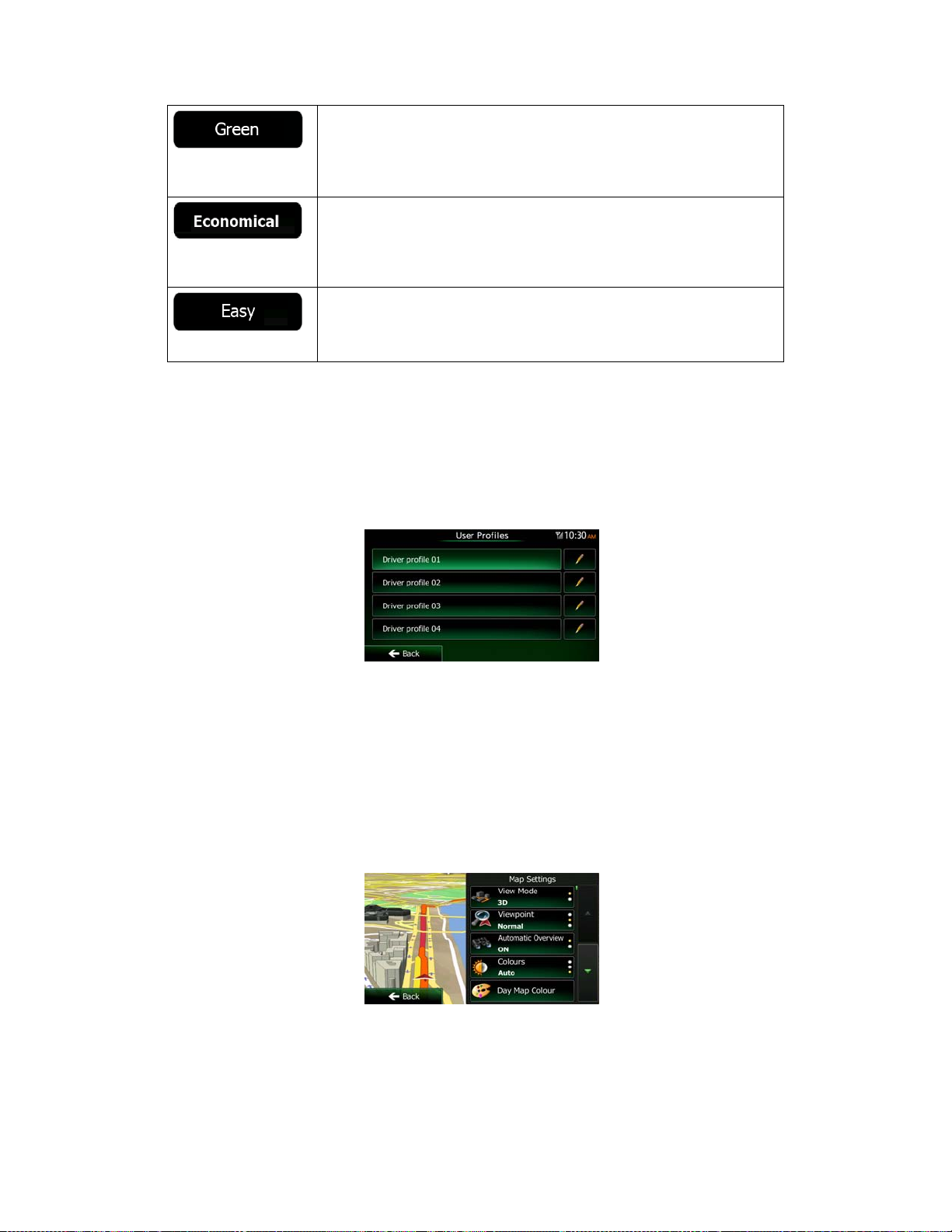
Gives a quick but fuel efficient route based on the fuel consumption
data given in Route settings (page 89). Travel cost and CO
emission
2
calculations are estimations only. They cannot take elevations, curves
and traffic conditions into account.
For vehicle types where Green routing is not available, this method
combines the benefits of Fast and Short: Clarion Mobile Map
calculates as if it were calculating the Fast route, but it takes other
roads as well to save fuel.
Results in a route with fewer turns and no difficult manoeuvres. With
this option, you can make Clarion Mobile Map to take, for example, the
motorway instead of a series of smaller roads or streets.
5.3.5 User profiles
If more drivers use Clarion Mobile Map for navigating, their settings can be remembered by
using one of the user profiles. Rename the profiles after tapping the edit button on the right so
that all users know which profile to use and switch between profiles by tapping its name. If
you select a new profile, the application restarts so that the new settings can take effect.
5.3.6 Map settings
You can fine-tune the appearance of the Map screen. Adjust the map view to your needs,
choose suitable colour themes from the list for both daytime and night use, change the red
arrow to a 3D car model, show or hide 3D buildings, turn track logging on or off, and manage
you Place visibility sets (which Places to show on the map).
The map is always shown on the screen so that you can see the effect when you change a
setting.
NX503E English 93
Page 94

Button Description
Switch the map view between a 3D perspective view and a 2D topdown view.
Adjust the basic zoom and tilt levels to your needs. Three levels are
available.
When selected, the map zooms out to show an overview of the
surrounding area if the next route event (manoeuvre) is far. When you
get close to the event, the normal map view returns.
Switch between daytime and night colour modes or let the software
switch between the two modes automatically a few minutes before
sunrise and a few minutes after sunset.
Select the colour scheme used in daytime mode.
Select the colour scheme used in night mode.
Replace the default position marker to one of the 3D vehicle models.
You can select separate icons for different vehicle types selected for
route planning. Separate icons can be used for car, pedestrian and the
other vehicles.
Show or suppress 3D landmarks, 3D artistic or block representations
of prominent or well-known objects.
Show or suppress 3D city models, 3D artistic or block representation
of full city building data containing actual building size and position on
the map.
Show or suppress the 3D elevation of the surrounding terrain.
Turn on or off track log saving, that is, saving the sequence of the
locations your journeys go through.
Select which Places to show on the map while navigating. Too many
Places make the map crowded so it is a good idea to keep as few of
them on the ma p as p os sibl e. For t his , you h ave the p oss ibi lit y to s ave
different Place visibility sets. You have the following possibilities:
Tap the checkbox to show or hide the Place category.
Tap the name of the Place category to open the list of its
subcategories.
Tap
or to load a previously saved one. Here you can also revert to
the default visibility settings.
to save the current Place visibility set
94 NX503E English
Page 95

5.3.7 Visual guidance settings
Adjust how the s of t war e he lps yo u na v ig at e wit h di f fer e nt k in ds of ro ut e re la t ed i nf orm a ti on o n
the Map screen.
The data fields in the corner of the Map screen can be customised.
Tap this butt on and s elec t the v alues you wa nt to see. T he val ues c an
be different when you navigate a route from when you are just cruising
without a given destination. You can select general trip data like your
current speed or the altitude, or route data related to your final
destination or the next waypoint on your route.
You may need a petrol station or a restaurant during your journey.
This feature displays a new button on the map when you are dr iving
on motorways. Tap this button to open a panel with the details of the
next few exits or service stations. Tap any of them to display it on the
map and add it as a waypoint to your route if needed.
Select the service types displayed for the motorway exists. Choose
from the POI categories.
Whenever adequate information is available, lan e information similar
to the real ones on road signs above the road is displayed at the top of
the map. You can turn this feature on or off.
If you are approaching a motorway exit or a complex intersection and
the needed information exists, the map is replaced with a 3D view of
the junction. You can turn this feature on or let the map be displayed
for the whole route.
When entering tunnels, the surface roads and buildings can be
disturbing. This feature shows a generic picture of a tunnel instead of
the map. A top-down overview of the tunnel and remaining distance
are also displa yed.
Turn on the route progress bar to see your route as a straight line on
the left side of the map. The red arrow represents your current position
and moves up as you travel. Waypoints and Traffic events are also
displayed on the line.
When you slow down while driving on a motorway, there is a chance
that you are in a traffic jam so Clarion Mobile Map offers you a detour
using the next exit. The message shows you distance of the exit and
the difference in distance and estimated time compared to the original
route. You c an choose from one of the following options:
Tap Dismiss or just ignore the message if you want to keep the
original route.
Tap Preview to see the overview of the original route and the
detour to make the decision. You can accept the detour as
offered or inc rease the bypassed moto r wa y se gment before
accepting.
Turn to the suggested new direction and the route will be
automatically recalculated.
NX503E English 95
Page 96

Similar to the above possibility, alternative routes can be suggested
when driving on normal roads. Clarion Mobile Map will select a
different turn in the upcoming intersection and offers you a different
route for th e next section of the route.
Your options are the similar as above but you cannot modify the
offered detour.
Parking at the destination may not be easy in city areas. As you
approach the destination, Clarion Mobile Map can offer parking
category Places near your destination. Tap the "P" button to open a
top-down map with the destination and the offered parking Places.
Select one and modify the route accordingly.
If you leave the recommended route and suddenly exit the motorway,
the application offers different alternatives near the exit like petrol
stations or restaurants. Also, if there are avoidable parts of the original
route ahead (like a tunnel, a toll road or a ferry), you will find them in
the list in case you want to bypass them with the help of Clarion
Mobile Map.
5.3.8 Display settings
Display related settings include menu animations, separate skins for daytime and night use
and the brightness of the display.
When animation is turned on, buttons on menus and keyboard
screens appear in an animated way. Screen transitions are also
animated.
5.3.9 Regional settings
These settings allow you to customise the application for your local language, measurement
units, time and date settings and formats, as well as to choose the time zone.
Button Description
This button displays the current written language of the user interface.
By tapping the button, you can select a new language from the list of
available languages. The application will restart if you change this
setting; you are asked to confirm this.
You can set the distance units to be used by the program. Clarion
Mobile Map m ay n ot support all the listed units in some voice guidance
languages.
Select between 12 and 24 hours time display and the various
international date display formats.
You can also set other country specific units used to display different
values in the application.
96 NX503E English
Page 97

By default, time zone is taken from the map information and adjusted
by your current location. Here you can set time zone and daylight
saving manually.
5.3.10 Trip monitor settings
Trip logs contain useful information about your trips. Trip logs can be saved manually when
you reach your destination or you can turn on the automatic saving here. You can access
these logs in the Trip monitor. Trip monitor is available from the More menu.
Trip monitor can record statistical data of your trips. If you need these
logs later, you can let the application save them automatically for you.
This is not a button. This line shows the current size of the trip
database, t he s u m of al l tr i p and track logs saved.
Track logs, the sequence of the positions given by the GPS receiver,
can be saved together with trip logs. They can later be displayed on
the map. You can let the application save the track log whenever it
saves a trip.
NX503E English 97
Page 98

6 Glossary
2D/3D GPS reception
The GPS receiver uses satellite signals to calculate its (your) position and needs at least four
signals to give a three-dimensional position, including elevation. Because the satellites are
moving and because objects can block the signals, your GPS device might not receive four
signals. If three satellites are available, the receiver can calculate the horizontal GPS position
but the accuracy is lower and the GPS device does not give you elevation data: only 2D
reception is possible.
Active route
The currently navigated route. Whenever the destination is set, the route is active until you
delete it, reach your destination or you quit Clarion Mobile Map. See also: Route.
City Centre
The city/town centre is not the geometric centre of the city/town but an arbitrary point the map
creators have chosen. In towns and villages, it is usually the most important intersection; in
larger cities, it is one of the important intersections.
Colour theme
Clarion Mobile Map comes with different colour themes for daytime or night use of the map
and menu screens. Themes are custom graphic settings and they can have different colours
for streets, blocks or surface waters in 2D and 3D modes, and they display shades or
shadows in different ways in 3D mode.
One daytime scheme and one night scheme is always selected for the map and for the
menus. Clarion Mobile Map uses them when it switches from day to night and back.
GPS accuracy
Several factors have impact on the deviation between your real position and the one given by
the GPS device. For example, signal delay in the ionosphere or reflecting objects near the
GPS device have a different and varying impact on how accurately the GPS device can
calculate yo ur position.
Map
Clarion Mobile Map works with digital maps which are not simply the computerised versions
of traditional paper maps. Similarly to the paper road maps, the 2D mode of digital maps
show you streets, roads, and elevation is also shown by colours.
In 3D mode, you can see the altitude differences, for example valleys and mountains,
elevated roads, and in selected cities 3D landmarks and 3D buildings are also displayed.
You can use digital maps interactively: you can zoom in and out (increase or decrease the
scale), you can tilt them up and down, and rotate them left and right. In GPS-supported
navigation, digital maps facilitate route planning.
98 NX503E English
Page 99

North-up map orientation
In North-up mode the map is rotated so its top always faces North. This is the orientation for
example in Find on Map.
Road Safety Camera
Special alert points for speed, red light or bus lane cameras. Different data sources are
available. You can configure Clarion Mobile Map to warn you when you approach one of
these cameras.
Detecting the location of Road Safety Cameras is prohibited in certain countries. It is the sole
responsibility of the driver to check whether this feature can be used during the trip.
The software is capable of showing and warning for more than just cameras. Various other
types of proximity alert points like school zones and railway crossings are also available.
Route
A sequence of route events, i.e. manoeuvres (for example, turns and roundabouts) to reach
the destination. The route contains one start point and one or more destinations. The start
point is the current (or last known) position by default. If you need to see a future route, the
start point can be replaced with any other given point.
Track-up map orientation
In Track-up mode the map is rotated so its top always points in the current driving direction.
This is the default orientation in 3D map view mode.
Vehimarker
The current position is shown with a red arrow on the map by default. The direction of the red
arrow shows the current heading. This position marker can be replaced with different 3D
vehicle symbols. You can even specify different Vehimarkers for different route types
(depending on which vehicle type is selected for route calculation).
NX503E English 99
Page 100

7 End User Licence Agreement
1 The contracting pa r t i es
1.1 This Agreement has been entered into by and between NNG Software Developing and
Commercial Ltd. (registered seat: 23 Bérc utca, H-1016 Budapest, Hungary; company
reg.no.: 01-09-891838) as Licensor (hereinafter: Licensor) and You as the end user
(hereinafter: User; the User and the Licensor jointly referred to as: Parties) in subject of the
use of the products specified in this Agreement, including software products, databases and
content .
2 Conclusion of the Agreement
2.1 The Parties hereby acknowledge that this Agreement shall be concluded by implicit
conduct of the Parties without signing the Agreement.
2.2 The User hereby acknowledges that following the lawful acquisition (online purchase from
authorized vendor or preinstalled on purchased Device) of the software product constituting
the object of this Agreement (Section 4), any degree of use, installation into a computer or
other hardware equipment (mobile phone, multi-function device, personal navigation device,
in-car navigation or multi function head unit, etc.) (hereinafter referred to as: “Device”),
installation of such Device into a vehicle, pressing of the “Accept” button displayed by the
software during installation or use (hereinafter referred to as: “Use”) shall mean that the User
has accepted the terms and conditions of this Agreement as legally binding. The time of
conclusion of the present Agreement is the time of executing the first action of use
(commencement of use).
2.3 This Agreement shall by no means authorize Use of the software product by those
persons having unlawfully acquired the software product or having unlawfully installed it on a
Device or in a vehicle.
2.4 U.S. Government Users. If you acquire the Software Product by or on behalf of the United
States Gover nment or any other entit y seeking o r applying ri ghts sim ilar to thos e customar ily
claimed by the United States Government, you are on notice that the Software Product and
the Databases, content and services are commercial items as that term is defined at 48 C.F.R
(“FAR”) 2.101 and that all use of the Software Product i s subject to this Agreement.
3 Applicable laws and regulations
3.1 Any action related to this Agreement will be governed by the laws of the Republic of
Hungary, with specific reference to Act IV of 1959 on the Civil Code and to Act LXXVI of 1999
on Copyrights (the “Copyright Act”) shall apply. The United Nations Convention on Contracts
for the International Sales of Goods is hereby excluded from application to this EULA.
3.2 The parties hereby agree that the courts of the Republic of Hungary will have exclusive
jurisdiction to rule on any disputes arising in connection with this Agreement.
3.3 The original language version of this Agreement is the Hungarian version. This
Agreement has versions in other languages as well. In case of dispute the Hungarian version
shall prevail.
4 Object of the Agreement and Termination
4.1 The object of this Agreement shall be the navigation guidance software product of
Licensor (hereinafter refe rred to as: the “Software Product”).
4.2 The Software Product shall include the operating computer program, its complete
documentation, the map database pertaining thereto and any third-party contents and
services accessible through the Software Product (hereinafter together referred to as: the
“Database”).
4.3 Any form of display, storage, coding, including printed, electronic or graphic display,
storage, source or object code, or any other as yet undefined form of display, storage, or
coding, or a ny medium thereof shall be deemed parts of the Software Product.
4.4 Error corrections, additions, updates or upgrades to the Software Product or the
Databases used by the User following the conclusion of this Agreement shall also be deemed
parts of the Software Product and Used in accordance with this Agreement.
100 NX503E English
 Loading...