

Page 1
TravelPilot Navigation
TravelPilot DX-V
Operating instructions
http://www.blaupunkt.com
Page 2
Overview
2
RC 09H remote control handset
12
11
13
2 3 41 6 7 85
10
9
14
Page 3

Overview
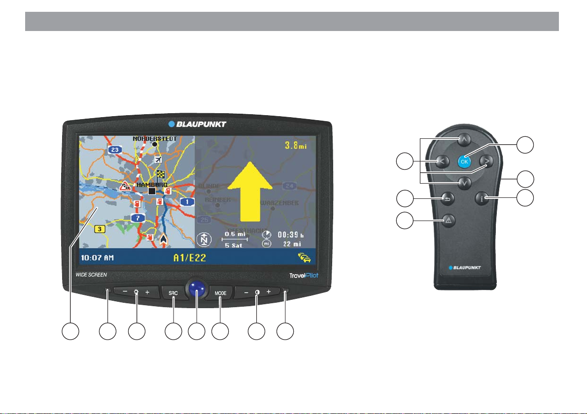
Monitor
1 Screen for displaying the symbol and map displays.
2 Infrared receiver for the RC 09H remote control handset.
3 Left +/- rocker switch for adjusting the brightness.
4 SRC button
Video source selection switch (navigation / external video input on the computer).
5 Blue button for switching the monitor on/off.
6 MODE button
For adjusting the 16:9 picture format (Full / Normal / Cinema).
7 Right +/- rocker switch for adjusting the contrast.
8 Brightness sensor.
RC 09H remote control handset
!
9
:
;
<
= Side button for activating the keypad
>
button for opening the menus for
dynamic route guidance and manual
traffic congestion detour.
button, correction button for deleting letters during character input
and for jumping back to the previous
menu.
buttons for selecting
menu items and letters.
OK
button for selecting menu items.
illumination.
button for repeating the last navigation voice output and for opening
the information menu. List entries
that are marked with “…” will be displayed in their entirety.
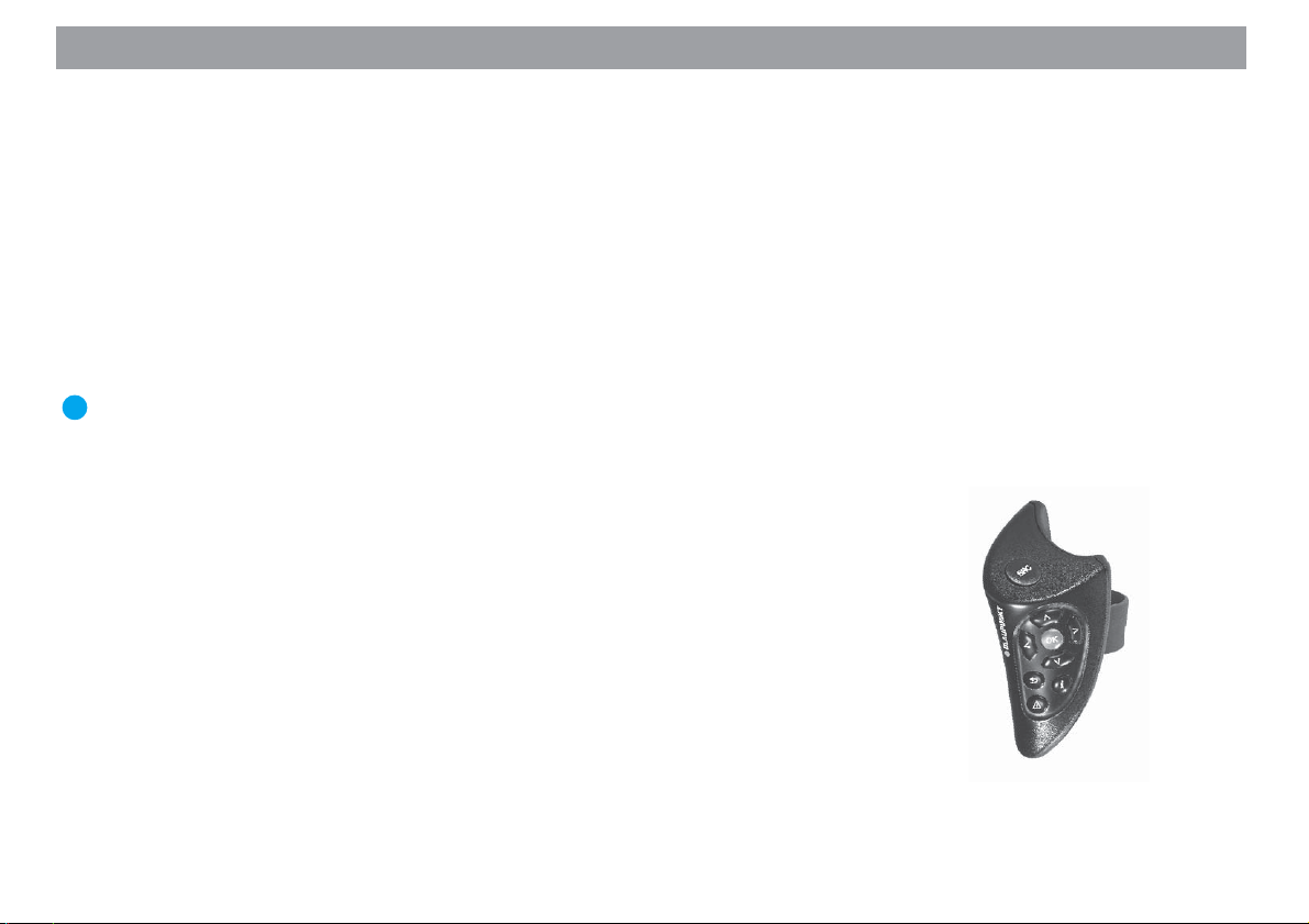
Plus Point: The optional RC 09
steering-wheel mounted infrared remote control can also be used for
operating the TravelPilot DX-V in the
same way conveniently from the
steering wheel.
Allgemeines Kurzanlei- TourenZieleingabe Zielspeicher Einstellun-
3
Anhang
Page 4
Safety Information
The TravelPilot DX-V has been designed for use in cars.
Such special information as height restrictions or maximum permissible loads as required for lorries or busses have
not been included on the navigation CDs.
Using the system while driving
If you do not pay attention to the current traffic situation at all times, you could easily cause serious traffic accidents.
To avoid being distracted by the TravelPilot DX-V, please observe the following information:
• Before you use the system for the first time, make yourself familiar with the TravelPilot DX-V and its operation.
• Find a suitable place to stop when you would like to re-program the TravelPilot DX-V.
• Never operate the TravelPilot DX-V while driving unless the traffic conditions permit.
• Do not make a destination entry unless your vehicle is stationary.
4
Page 5

Contents
Overview .............................................. 2
Safety Information............................... 4
Introduction ......................................... 6
General Information ............................7
About these operating instructions........ 7
Accessories........................................... 7
How navigation works ........................... 8
Switching the unit on .............................8
Quick Reference................................ 10
Meaning of the icons in the menus .....10
Marking menu items............................ 10
Selecting menu items.......................... 10
Exiting menus......................................10
Direct destination entry in 10 steps ..... 11
Saving the current destination with a
short name before beginning route
guidance..............................................14
An example of route guidance using
the map display ...................................14
Entering destinations ....................... 18
Entering the destination when you
know the address ................................18
Selecting surrounding destinations
(car parks, petrol stations, etc.)........... 20
Selecting non-urban destinations
(motorway exits, service stations,
airports or border crossings) ............... 21
Entering destinations using
coordinates..........................................22
Entering destinations in map mode..... 23
Destinations in the destination
memory ............................................... 26
Route guidance ................................. 27
Starting route guidance .......................27
Restarting interrupted route guidance. 27
Adjusting the volume of the voice
output .................................................. 28
Requesting destination and route
information ..........................................28
Route guidance in the arrow symbols
mode ................................................... 29
Route guidance with map display .......30
Using the traffic congestion function ... 36
Dynamic route guidance with TMC.. 39
Switching TMC on/off ..........................40
Selecting the TMC station with the
TMC D-Namic tuner box .....................40
Selecting the TMC station with the
car radio .............................................. 41
Calculating the route with TMC while
route guidance is in progress ..............42
Displaying traffic messages ................42
Selecting route options .................... 44
Altering route options prior to route
guidance..............................................44
Altering the route options while route
guidance is in progress ....................... 45
Saving your settings............................ 45
Destination memory ......................... 46
Saving destinations .............................47
Deleting destinations from the
destination memory............................. 49
Sorting the destination memory ..........50
Tour memory ..................................... 51
Entering tour destinations ...................51
Sorting the tour list .............................. 53
Deleting tour destinations....................53
Deleting the whole tour ....................... 54
Starting route guidance to a tour
destination........................................... 54
Travel guides ..................................... 55
Activating the travel guide ...................55
Other functions ................................. 56
Map display without route guidance.... 56
Accessing the on-board computer ......56
System settings................................. 57
Accessing the main menu for system
settings................................................ 57
Audio/video settings ............................57
Basic settings ......................................60
Other settings...................................... 63
Calibration settings..............................67
Appendix............................................ 69
Changing the navigation CD-ROM...... 69
Compatible navigation CD-ROMs .......69
Care tips for CD-ROMs .......................69
Available navigation CD-ROMs...........70
Available travel guide CD-ROMs ........ 70
Wide screen monitor settings.......... 71
Index................................................... 73
Allgemeines Kurzanlei- TourenZieleingabe Zielspeicher Einstellun-
5
Anhang
Page 6

Introduction
Dear Customer,
Congratulations on buying the TravelPilot DX-V. You can rest assured that you have
made the right choice by buying the TravelPilot DX-V.
The TravelPilot DX-V is a reliable and easy-to-use navigation system that will lead
you with precision through the traffic to your destination.
These operating instructions will take you step by step through the functions of the
TravelPilot DX-V and will answer the most frequently asked questions. You will find
further information on using these instructions in the section entitled “About these
operating instructions”.
If you have any further questions or comments regarding the TravelPilot DX-V, please
do not hesitate to call our telephone hotline or contact your Blaupunkt dealer. The
international telephone hotline numbers are printed on the last page of these instructions.
We provide a manufacturer guarantee for our products bought within the EU. You can
view the guarantee conditions at www.blaupunkt.de or ask for them directly at:
Blaupunkt GmbH
Hotline
Robert Bosch Str. 200
D-31139 Hildesheim
Notice regarding liability
Despite constant technical developments, the navigation system may in isolated cases provide incorrect or unoptimised navigation due to improper operation, changes to
the traffic flow regulation, construction sites, traffic load, errors or missing information
on the navigation data media or general calculation and positioning errors. Blaupunkt
does not accept liability and does not provide compensation for any damages or other
drawbacks arising from this.
6
Page 7
General Information
About these operating instructions
These operating instructions were written to provide you with information on the operation and functions of your TravelPilot DX-V and to allow you to operate the equipment easily and correctly.
Please read these instructions carefully before you use your TravelPilot DX-V for the
first time and keep them handy for future reference in the car.
To allow you to find information quickly and easily, the following icons have been used
in these instructions to indicate the individual steps:
1. … This icon indicates steps you must perform in order to complete a function.
✔ The way in which the equipment should react after you perform a function is
indicated like this.
Plus Point: This indicates special information and tips on how to use the
TravelPilot DX-V.
Note
If you decided in favour of the version equipped with the wide vision TV
monitor, you will find separate operating instructions for the monitor
enclosed.
Accessories
RC 09 infrared steering-wheel remote control
RC 09 infrared steering-wheel remote control allows you to conveniently operate the
TravelPilot DX-V directly from the steering wheel.
TMC D-Namic tuner box
For dynamic navigation (automatic detours around traffic congestion), the TravelPilot
DX-V must be connected to a TMC source (Traffic Message Channel). It is possible to
purchase a “TMC D-Namic tuner box” as an accessory to receive TMC data.
RC 09 infrared steering-wheel remote control
Allgemeines Kurzanlei- TourenZieleingabe Zielspeicher Einstellun-
7
Anhang
Page 8

General Information
You can also use the TMC data received by a Blaupunkt car radio. To find out which
Blaupunkt car radios are equipped to receive TMC data and relay this information to
the TravelPilot DX-V, please contact your Blaupunkt specialist dealer or ring the Blaupunkt telephone hotline. The hotline number is listed on the last page of these instructions.
How navigation works
Your TravelPilot DX-V uses GPS, a satellite-supported locating system, to determine
the current position of the vehicle. GPS stands for Global Positioning System, a system which can be used to reliably determine your location anywhere in the world. A
“gyroscope” and the electronic speedometer signal are also used to track the vehicle’s movements. The TravelPilot DX-V navigation system compares this data with
the data stored in digital form on the navigation CD-ROM and uses it to calculate the
routes in route guidance.
If the TravelPilot DX-V is connected to a TMC source (“TMC D-Namic tuner box” or
appropriately equipped car radio), it will be able to take the current traffic situation into
account when calculating the route. For more information on TMC, please refer to the
section on “Dynamic Route Guidance with TMC”.
Switching the unit on
If the TravelPilot DX-V has been properly connected to the vehicle ignition and continuous plus, the TravelPilot DX-V will switch on automatically when you start your vehicle.
8
Page 9
General Information
Operating introduction
When the system is started for the first time, an operating introduction explaining the
functions of the remote control will appear. Then you can select whether or not this
introduction is shown each time the TravelPilot DX-V is switched on.
Plus Point: You can activate or deactivate the operating introduction at any
time in the “Settings” menu. For more information, please refer to the section
on “Settings”, “Switching the operating introduction on/off”.
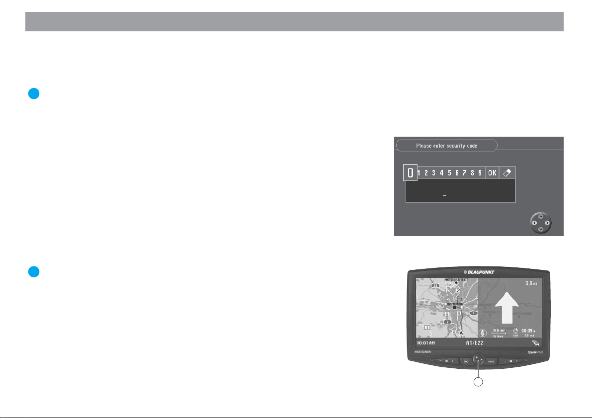
Theft protection system
It is possible to activate a coding for your TravelPilot DX-V so that the TravelPilot
DX-V cannot be operated after it has been disconnected from the battery (e.g. in the
event that it is stolen).
If the coding is active, it will be necessary to enter the code number before the unit
can be operated again after it has been disconnected from the battery. You will find
the code number in the TravelPilot DX-V equipment passport. Never keep this pass-
port in your vehicle!
For more information on activating/deactivating the coding and how to switch on coded equipment after it has been disconnected from the battery, please refer to the
section on “Settings”, “Activating/deactivating the safety code”.
Plus Point: This electronic theft protection system prevents unauthorised
persons from using the TravelPilot DX-V after it has been removed from the
vehicle.
Switching off
For technical reasons it is not possible to switch off the TravelPilot DX-V computer.
However, if required, you can switch off the display by pressing the blue button 5 on
the monitor. Spoken driving recommendations are played even if the display is switched
off. The display can be switched on again by pressing the blue button 5 once more.
Allgemeines Kurzanlei- TourenZieleingabe Zielspeicher Einstellun-
5
9
Anhang
Page 10
Quick Reference
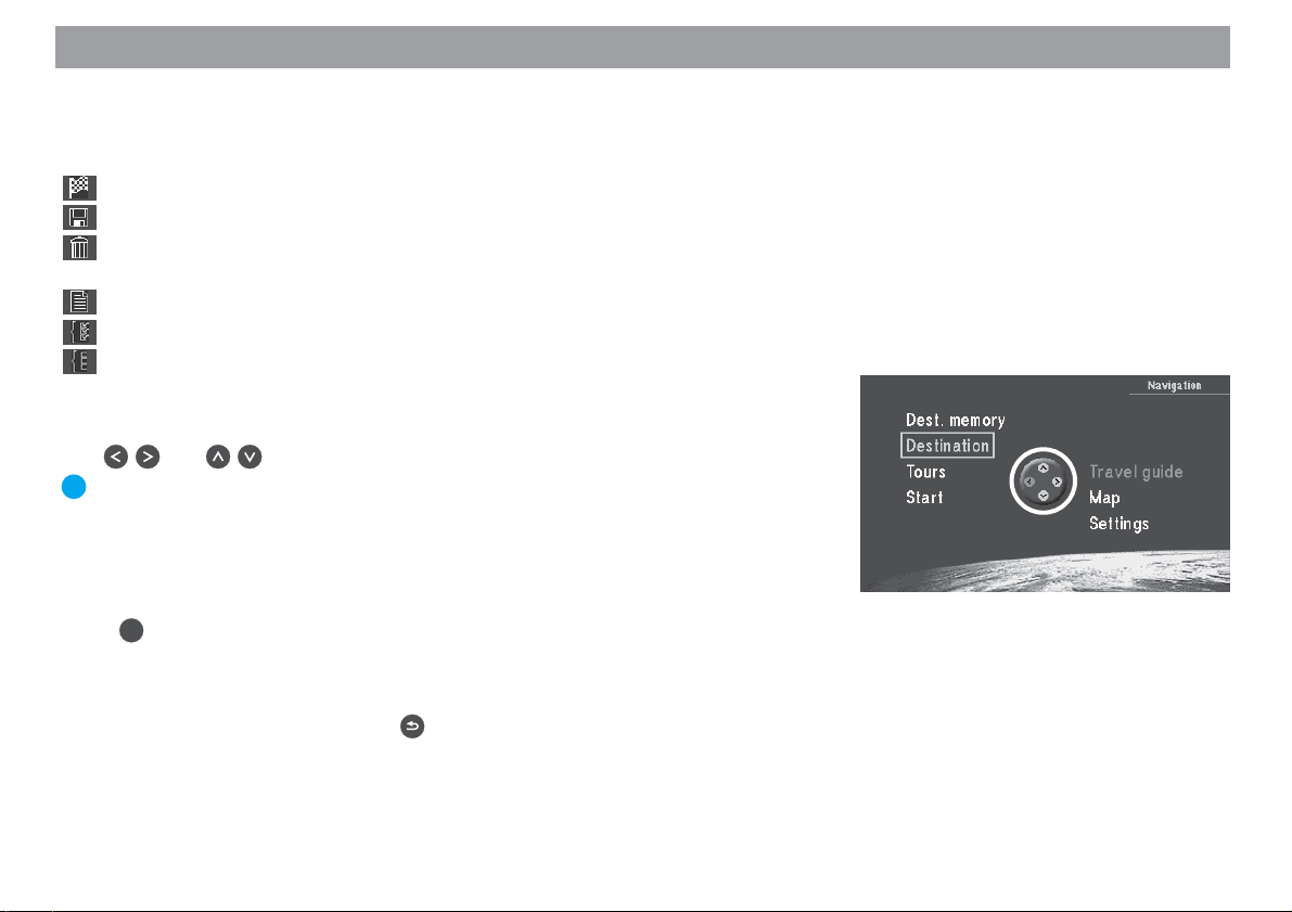
Meaning of the icons in the menus
In various menus, functions are activated and actions carried out by marking and
confirming icons. The most important icons are shown and explained here:
- Icon: for starting the route calculation and route guidance
- Icon: for saving addresses and settings
- Icon: for deleting addresses after they have been entered / for resetting
the on-board computer
- Icon: for activating the list function when entering a destination
- Icon: all options are activated
- Icon: all options are deactivated
Marking menu items
Use and on the remote control to move the selection bar.
Plus Point: The operating assistant (highlighted in the picture) indicates in
yellow which directional arrows on the remote control can be used in the current menu.
Selecting menu items
Press OK on the remote control to select a marked menu item.
10
Exiting menus
If you would like to exit a menu, press on the remote control.
Page 11
Quick Reference
The following three examples have been included to familiarise you quickly with the
basic functions of the TravelPilot DX-V:
– Direct destination entry in a city indicating the street and a junction
– Entering a name for the destination and saving it in the destination memory
– Route guidance using the map: altering the map scale and the map informa-
tion
For more information on entering destinations, please refer to the section on “Entering destinations”.
Direct destination entry in 10 steps
The following is an example of how to enter a destination.
City/town: Berlin
Street: Alexanderplatz
Junction: Alexanderstraße
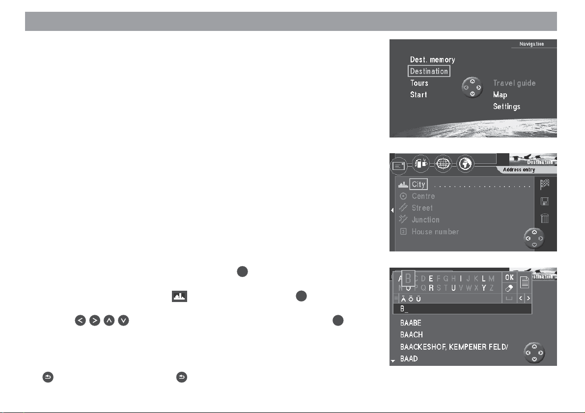
City/town:
1. Switch on the vehicle ignition.
The main menu will appear. ✔
OK
2. Select “Destination” in the main menu. Press
The “Destination” menu will appear. ✔
3. Mark the item containing the icon (city/town). Press the OK button.
The character set used to enter the name of the city/town will appear. ✔
4. Use on the remote control to mark the letter “B”. Press OK.
The first city/town starting with the letter “B” will appear on the list (below the
character set). ✔
Note
You can delete letters that you have entered by repeatedly pressing the
button. A long press on the button will close the input menu.
Allgemeines Kurzanlei- TourenZieleingabe Zielspeicher Einstellun-
.
11
Anhang
Page 12
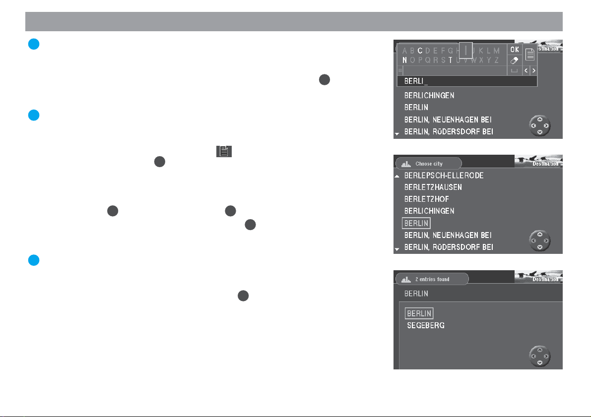
Quick Reference
Plus Point: With each letter you enter in the name, the list will automatically
forward to the corresponding place names. This helps you to find the name
of the city/town you are looking for quickly.
5. Mark the letters “E”, “R”, “L” and “I” one after the other and press OK for each
letter.
“BERLIN” will appear on the list. ✔
Plus Point: Those letters that cannot logically follow on from the ones you
have just entered will be displayed greyed out and therefore cannot be selected.
6. To switch to the list of places, mark the icon in the speller (letter selec-
tion field) and press the OK button.
The list of places is displayed. ✔
Note
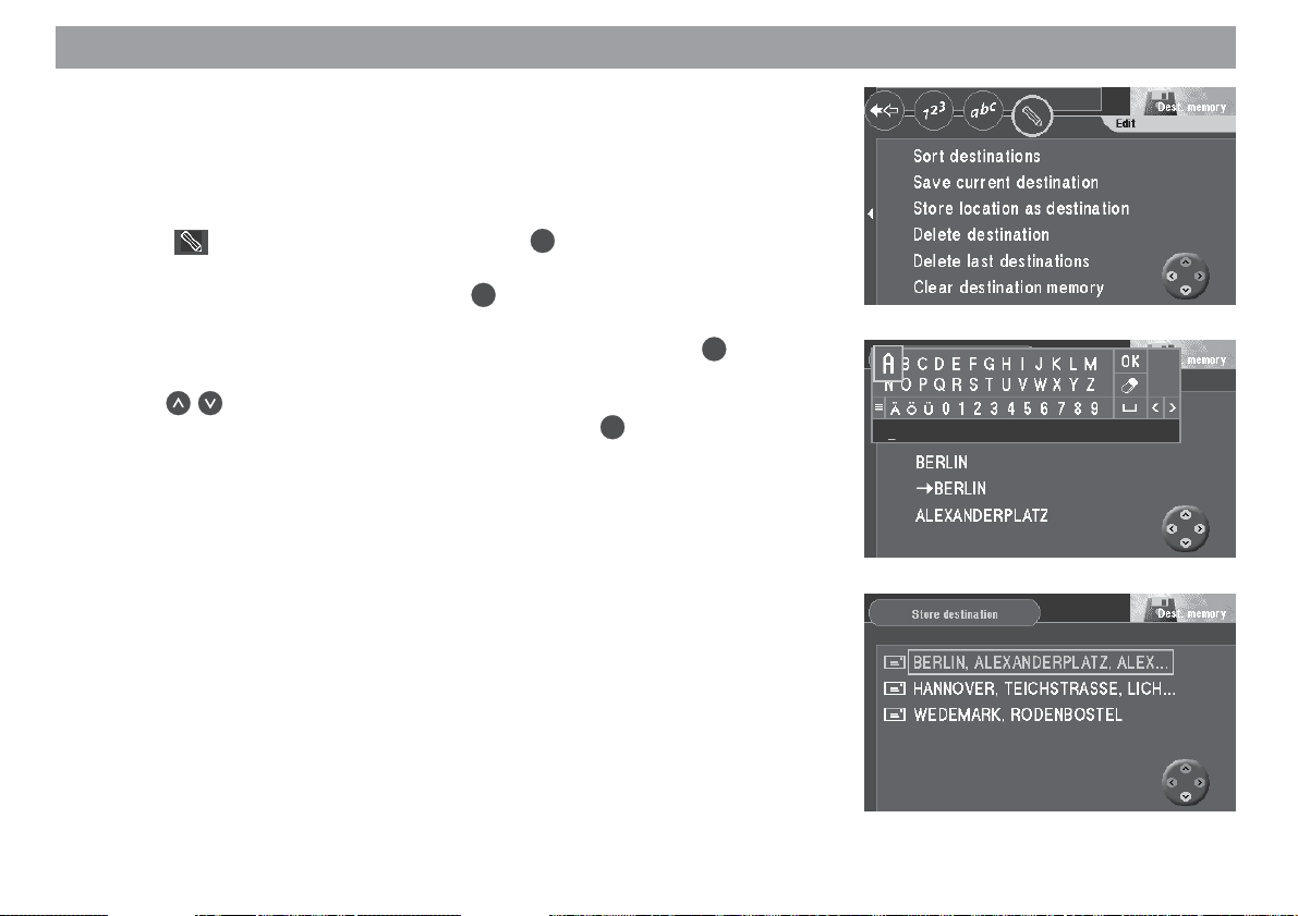
To select the first place in the displayed list, mark “OK” in the speller and
OK
then press the
7. Mark “BERLIN” on the place names list. Press
Because Berlin is listed twice for Germany (as the capital city and as a part
of Segeberg), an additional menu to specify the city/town will appear. ✔
Plus Point: The last 20 towns/cities that were entered will be saved automatically. This enables you to quickly find frequently selected towns/cities since
these are displayed directly in the input field.
8. Mark “BERLIN” in the selection menu. Press OK.
The “Destination” menu will appear again on the screen. ✔
button or just press the OK button for a longer period.
OK
.
12
Page 13
Quick Reference
Street:
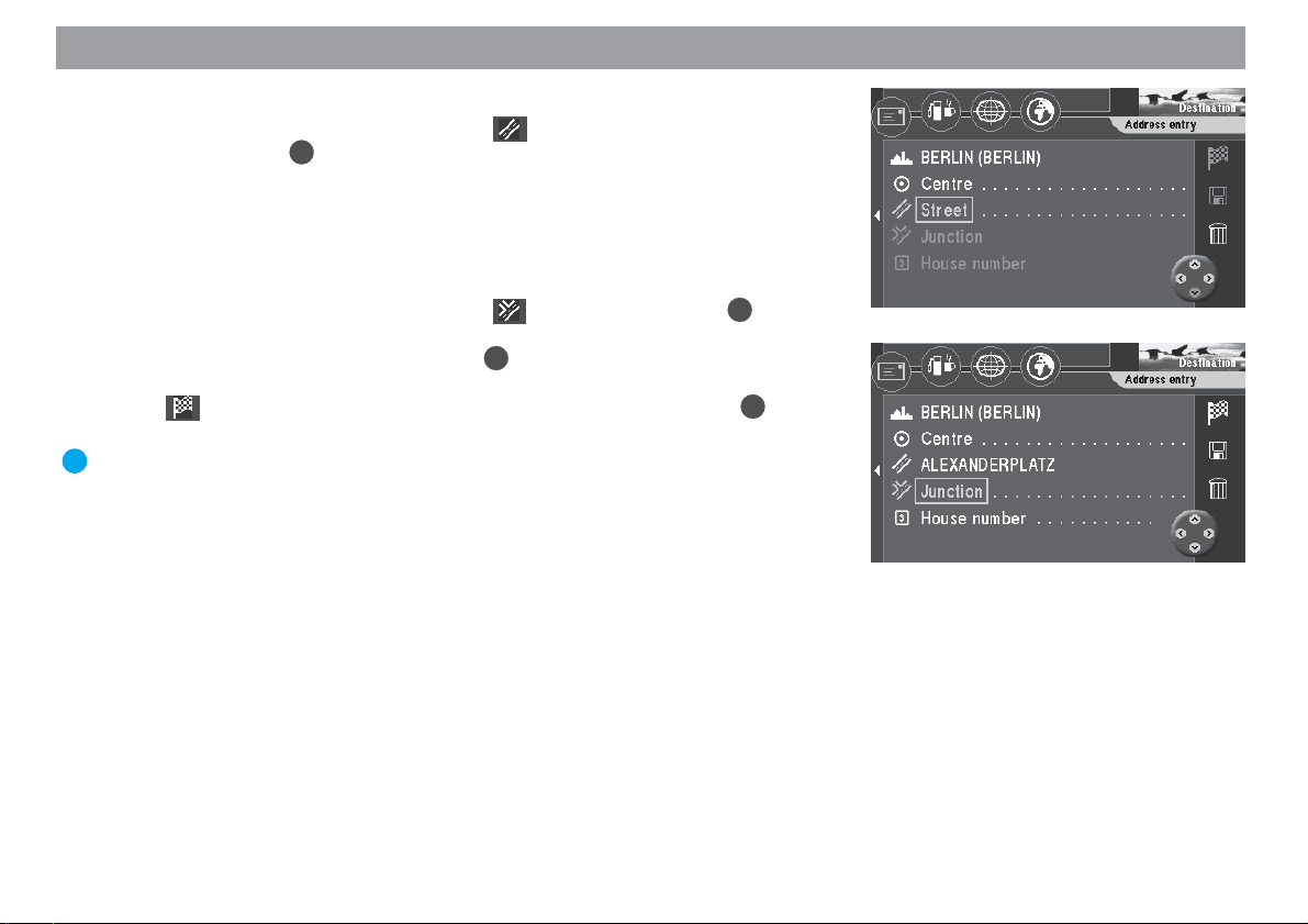
9. The selection bar will automatically mark
OK
tion” menu. Press
The character set used to enter the street name will appear. ✔
Enter the letters for “Alexanderplatz” in the same way as described for entering the city/town.
Junction:
10. The selection bar will automatically mark
The selection list displaying the available junctions will appear. ✔
Select “ALEXANDERSTRASSE”. Press OK.
The “Destination” menu will appear. ✔
The
ton.
Plus Point: After you have entered your destination completely and before
you begin route guidance, it is possible to save the destination in the destination memory.
icon is marked. You can now start route guidance using the OK but-
.
(street icon) in the “Destina-
(junction icon). Press OK.
Allgemeines Kurzanlei- TourenZieleingabe Zielspeicher Einstellun-
13
Anhang
Page 14
Quick Reference
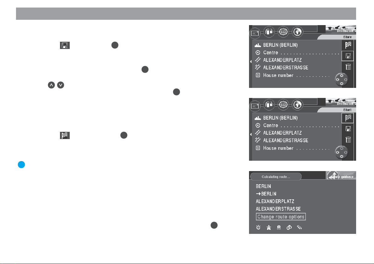
Saving the current destination with a short name before beginning route guidance
1. Mark the icon. Press the OK button.
The speller for entering the destination name will appear. ✔
2. Enter a name for your destination, e.g. “HOTEL”, as described above.
3. Mark “OK” in the character set and press OK.
The “Store destination” menu will appear. ✔
4. Use to move the name of the destination to the position in which you
OK
would like to save it in the destination memory. Press
The main menu will appear. ✔
An example of route guidance using the map display
After you have entered your destination, you can start route guidance.
1. Mark the icon and press the OK button.
A menu indicating the data on the current destination will appear. ✔
You will hear the following voice output: “The route is being calculated.” You
can use this menu to alter the route options.
Plus Point: You can alter the route options at any time while route guidance
is in progress. For more information, please refer to the section on “Selecting
route options”, “Altering route options while route guidance is in progress”.
.
14
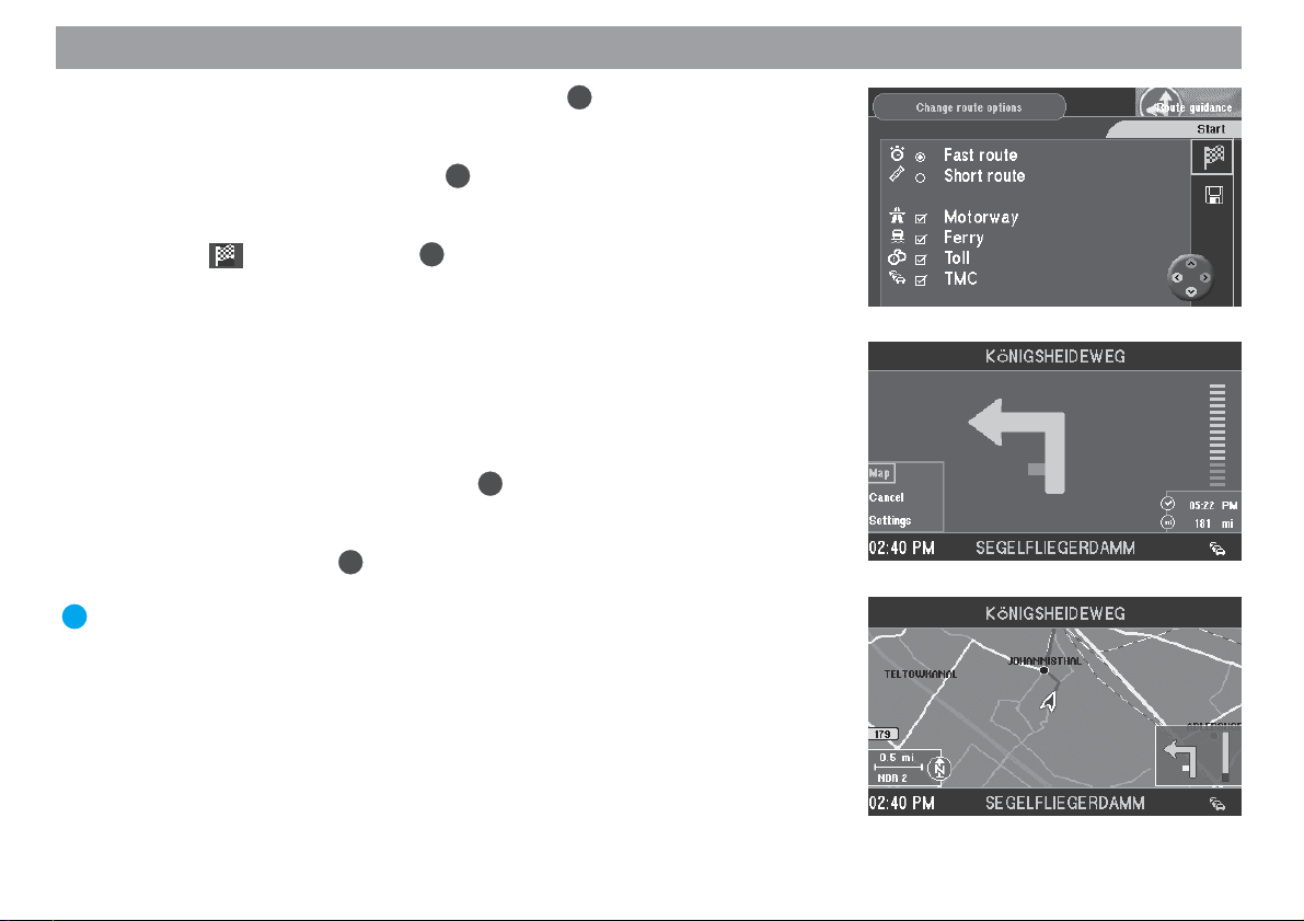
Altering the route options before beginning route guidance
The example of route guidance will be calculated using the route options for “Short
route” and “Avoid motorways”.
2. When the menu indicating the destination data appears on the screen, the
OK
selection bar will mark the “Change route options” menu item. Press
The “Change route options” menu will appear. ✔
.
Page 15
Quick Reference
3. Move the selection bar to “Short route” and press OK.
You have now selected the “Short route” option. ✔
4. If “Motorway” is activated (a checkmark will appear in the box), move the selection bar to “Motorway” and press OK.
“Motorway” will be deactivated. There will no longer be a checkmark in front
of “Motorway”. ✔
5. Mark the
You will hear the following voice output: “The route is being calculated.” ✔
After the route has been calculated, route guidance will begin. You will hear
the first spoken driving recommendation for route guidance. The system will
use the display mode selected last (arrow symbol route guidance or map display).
Switching to map display
6. If the display mode used last was arrow symbol route guidance, you can
switch to map display as follows: Press
progress.
A selection menu will appear at the bottom left-hand edge of the screen. ✔
7. Select “Map” and press
The map display will appear. ✔
Plus Point: You can use the selection menu while route guidance is in
progress to switch quickly back and forth between the symbol and map display modes.
icon and press the OK button.
OK
OK
.
while route guidance is in
Allgemeines Kurzanlei- TourenZieleingabe Zielspeicher Einstellun-
15
Anhang
Page 16
Quick Reference
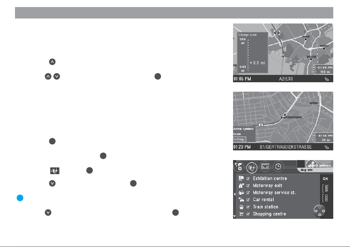
Altering the map scale
If your destination is located at a considerable distance away from your current position, you may want to select a map scale which offers you a better overview of your
complete route. Once you get closer to your destination, you can alter the map scale
to obtain more detailed information on the area surrounding your destination.
8. Press while the map is on display.
A window in which you can alter the map scale will appear. ✔
9. Use to select the desired map scale. Press OK.
The map will appear in the scale selected. ✔
Displaying information on the map
As you get closer to your destination, you can have such additional information as the
locations of parking garages, public institutions or petrol stations displayed on the
map.
In this example of route guidance, parking garages/car parks and petrol stations will
be displayed on the map.
OK
10. Press
A selection menu will appear at the bottom left-hand edge of the screen. ✔
11. Select “Settings” and press OK.
The “Settings” menu will appear. ✔
12. Select
The “Map info” selection menu will appear on the screen. ✔
Press to select “Car park” and press OK.
A checkmark will appear in the box to the left of the menu item. ✔
Plus Point: You can easily tell whether an option is active or not; if it is, there
will be a checkmark in front of the menu item.
13. Use
A checkmark will appear in the box to the left of the menu item. ✔
while route guidance is in progress.
and press OK.
to select the “Petrol station” menu item and press OK.
16
Page 17
Quick Reference
14. Use the button to select the “OK” menu item on the right side of the
menu. Press the OK button.
The map display containing the selected icons appears. ✔
Plus Point: If you want to display all the information on the map, mark the
icon (if you want to hide all the information mark the icon) on the
OK
right side of the menu and press the
15. When you have reached your destination and route guidance ends, the map
display will remain active. If you would like to enter a new destination,
press .
The main menu will appear. ✔
For more information on route guidance and a detailed description of route guidance
and display modes, please refer to the section on “Route guidance”.
button.
Allgemeines Kurzanlei- TourenZieleingabe Zielspeicher Einstellun-
17
Anhang
Page 18
Entering destinations
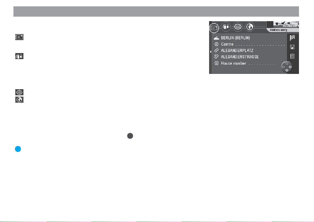
Using the four icons on the top line of the “Destination” menu you can enter your
destination in the following ways:
Use the envelope icon to enter your destination directly with the exact address using the following menu items: “City” - “Centre” - “Street” - “Junction” “House number”.
Using the petrol pump / cup icon, you can make your selection from a list of
surrounding destinations such as car parks, hospitals, petrol stations, train
stations and other public facilities. These destinations can be accessed for
the area around your position, for the last destination that you navigated to
and for the area around a selectable town, or they can be non-urban destinations like motorway service stations or airports.
You can use the coordinate grid to enter your destination using coordinates.
Use the globe icon to enter a destination directly on the map.
In addition, you can also recall a saved destination from the destination memory to
use as your new destination.
Entering the destination when you know the address
1. Select “Destination” in the main menu. Press OK.
The “Destination” menu will appear. ✔
Plus Point: Each time you access the “Destination” menu, the envelope will
automatically be selected for the direct entry of an address.
You can find an example of how to directly enter an address with a town, street and
junction in the Quick Reference text. You can also enter a part of the town (town
centre) or a house number as part of the address.
18
Page 19

Entering destinations
Selecting a town centre (part of town) as your destination
In large cities you can also enter a part of the city as your destination.
1. To enter a town centre as your destination, first enter the town.
The “Destination” menu will appear. ✔
2. Mark
Now you will see a list of the city centres available (for a maximum of 12 entries) or a character set (for more than 12 entries). ✔
3. Use the speller to enter the name of the required centre or confirm the existing entry. Confirm the first entry in the list using the
of centres using the
4. Mark the centre you wish to select. Press
The “Destination” menu will appear. ✔
The selection marker is positioned over the
route guidance using the OK button. For further details, read the chapter entitled “Route Guidance”.
Entering the house number
The house number can also be added to the destination entry. However, the navigation CD used must contain corresponding data.
1. First enter a city and a street.
2. Mark
A list of numbers representing the house numbers will appear. ✔
3. To enter the house number, proceed as described for entering the city/town.
Select the desired block of house numbers from the list. Press OK.
The “Destination” menu will appear. ✔
The selection marker is positioned over the
route guidance using the OK button. For further details, read the chapter entitled “Route Guidance”.
(icon for the centre). Press OK.
icon.
OK
.
(icon for the house number). Press OK.
icon or open the list
icon. You can now start
icon. You can now start
Allgemeines Kurzanlei- TourenZieleingabe Zielspeicher Einstellun-
19
Anhang
Page 20
Entering destinations
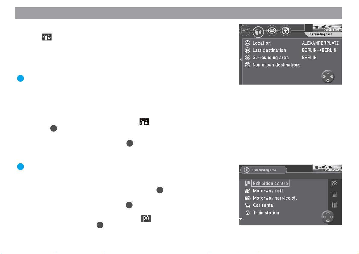
Selecting surrounding destinations (car parks, petrol stations, etc.)
Using the icon (petrol pump / cup) you have access to various destinations. You
can select these destinations according to your current location (“Location”), the last
active navigation destination (“Last destination”), any place (“Surrounding area”) or
non-urban destinations (e.g. border crossings, airports). In the case of “Location” and
“Last destination”, the destinations are sorted according to their distance, in the case
of “Surrounding area” they are displayed alphabetically.
Plus Point: This is helpful, for instance, when you are looking for the nearest
petrol station.
The destinations available in the surrounding area differ according to your location or
the area around your destination and they refer to an area of approximately 12 mi
radius (50 mi in the case of airports). The exact radius depends on the navigation CDROM.
1. To select a surrounding destination, select
OK
Press
2. Move the selection bar to the desired reference point (“Location”, “Last destination” or “Surrounding area”). Press OK.
3. If you select “Surrounding area”, you must have first entered the place at
which you want to select a surrounding destination.
Plus Point: Enter the destination here in the same way as described for the
direct destination entry.
Once you have determined the town/city, the list of destinations will appear. ✔
4. Select the desired surrounding destination. Press OK.
The list of available destinations will appear. ✔
5. Select the desired destination. Press OK.
The name of the destination will appear in a menu. ✔
The selection marker is positioned over the
route guidance using the OK button. For further details, read the chapter entitled “Route Guidance”.
. The “Surrounding dest.” menu will appear. ✔
in the “Destination” menu.
icon. You can now start
20
Page 21
Entering destinations
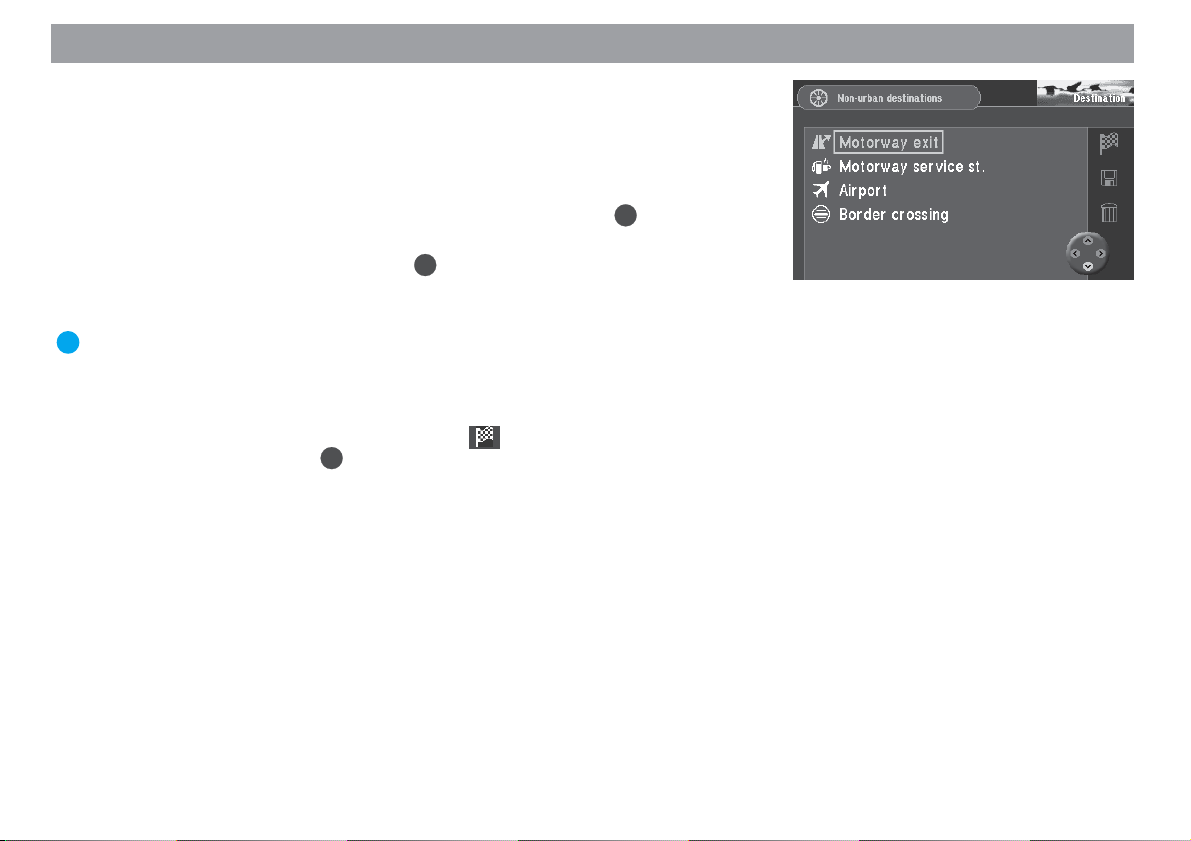
Selecting non-urban destinations (motorway exits, service
stations, airports or border crossings)
Using the “Non-urban destinations” menu item, you can select motorway junctions,
service stations, airports and border crossings for the entire country. All you need
know is the name.
OK
1. Select the “Non-urban destinations” menu item and press the
A list of the available non-urban destinations is displayed. ✔
2. Select the desired menu item. Press OK.
The character set used to enter the name of the destination will appear. ✔
3. Enter the name of the destination.
Plus Point: Enter the destination here in the same way as described for the
direct destination entry.
After you have selected the destination, the destination name will appear in a
menu. ✔
The selection marker is positioned over the
route guidance using the OK button. For further details, read the chapter entitled “Route Guidance”.
icon. You can now start
button.
Allgemeines Kurzanlei- TourenZieleingabe Zielspeicher Einstellun-
21
Anhang
Page 22
Entering destinations
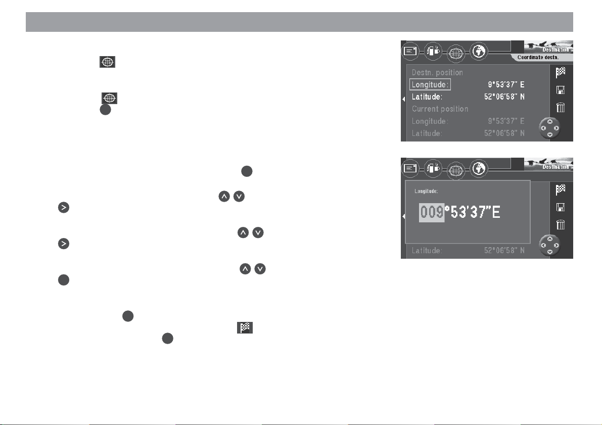
Entering destinations using coordinates
You can use the icon (coordinate grid) for entering your destinations as coordinates. To do so, you will need to enter the coordinates in degrees of longitude and
latitude.
1. Select the icon in the top line of the “Destination” menu.
Press the OK button.
The coordinate input menu is displayed. ✔
You can now enter the coordinates you want under “Destn. position”. If satellite reception in your area is sufficient, your current position is also shown under “Current position”.
2. Select the “Longitude” menu item. Press the OK button.
The field for entering the number of degrees is marked. ✔
3. Enter the number of degrees using the buttons. Then press the
button.
The field for entering the number of minutes is marked. ✔
4. Now enter the number of minutes using the buttons. Then press the
button.
The field for entering the number of seconds is marked. ✔
5. Now enter the number of seconds using the buttons. Then press the
OK
button.
The coordinate input menu is displayed again. ✔
6. Now enter the latitude coordinates in the same way.
OK
Then press the
The selection marker is positioned over the icon. You can now start
route guidance using the
titled “Route Guidance”.
Note
The switch between north/south and east/west when entering the coordinates takes place automatically when the number of degrees is entered.
button.
OK
button. For further details, read the chapter en-
22
Page 23
Entering destinations
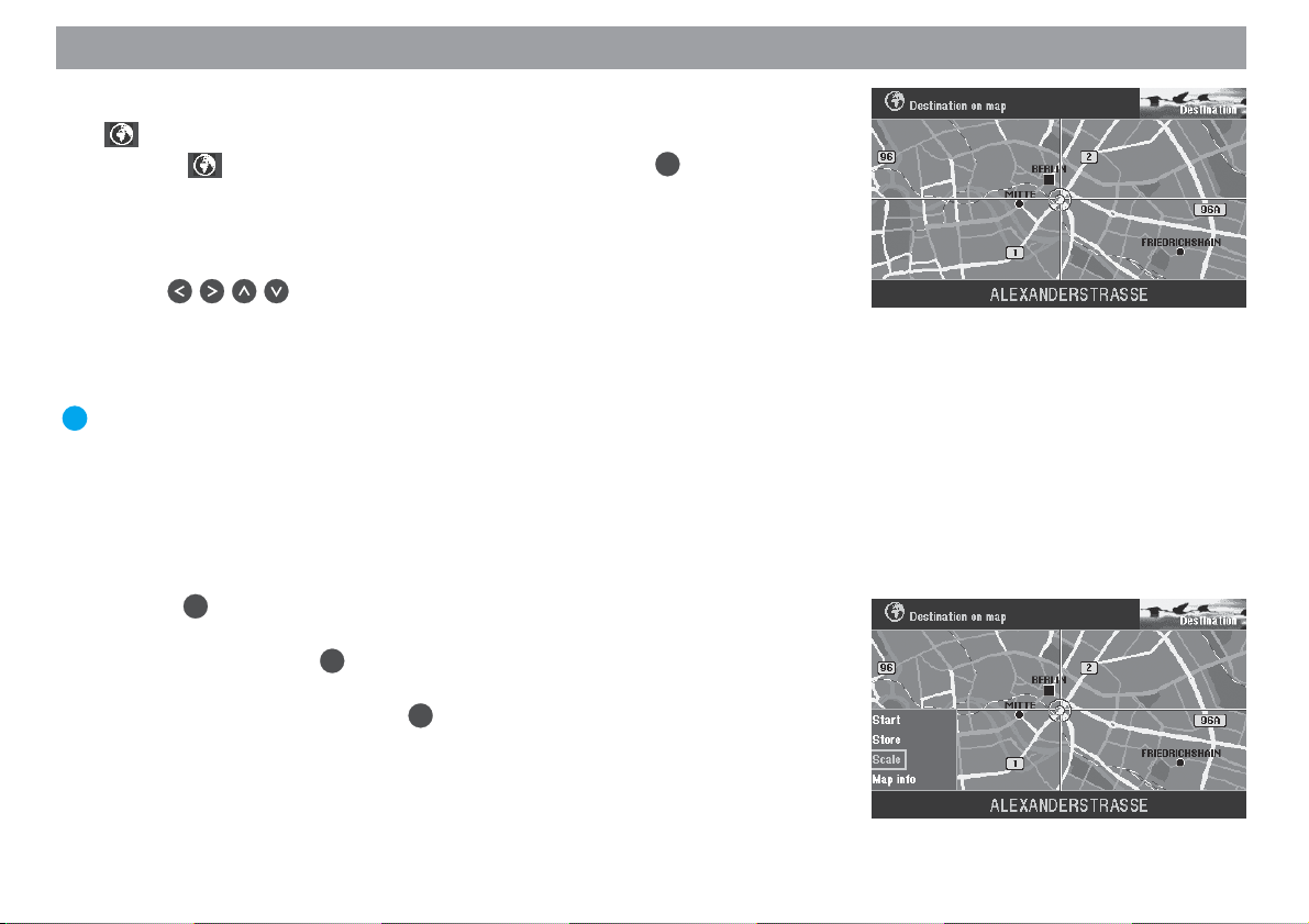
Entering destinations in map mode
Use (the globe icon) to determine a destination for navigation in map mode.
1. Select on the top line of the “Destination” menu. Press OK.
A map which indicates north facing up will appear. ✔
The map will show the surroundings of the last active destination. If no destination has been entered, the map will indicate the current vehicle location.
Use the cross wires to select the destination.
2. Use
rection of the desired destination.
The cross wires will move across the display. ✔
If you move the cross wires over the edge of the map, the next section of the
map will appear automatically.
Plus Point: Depending on the map scale, the name of the street or the name
of the town/city over which the cross wires are passing will appear on the
line below the map.
Adjusting the map scale
If the destination is far away from your current location, you can alter the map scale,
allowing you to move the cross wires quickly over long distances.
1. Press
A selection menu will appear. ✔
2. Select “Scale”. Press OK.
A window you can use to alter the map scale will appear. ✔
3. Select the desired scale. Press OK.
The map will appear in the new scale. ✔
on the remote control to move the cross wires in the di-
OK
while the map is on display.
Allgemeines Kurzanlei- TourenZieleingabe Zielspeicher Einstellun-
23
Anhang
Page 24

Entering destinations
Displaying information on the map
You can also have such additional information as car parks and petrol stations displayed in symbol form on the map.
1. Press OK to open the selection menu.
2. Select “Map info”. Press
A selection list containing the information available will appear. ✔
3. Mark the information you want displayed on the map. Press
lection.
A “checkmark” should appear in front of every type of information you want
displayed. ✔
4. Once you have selected all of the information you want displayed on the
map, press
.
“OK” on the right side of the menu is marked. ✔
5. Press OK.
The map displaying the information selected will appear. ✔
Starting route guidance
Once you have determined the destination on the map, you can start route guidance
directly.
1. Press OK to access the selection menu.
2. Select “Start”. Press OK.
A menu containing the data on the current destination will appear. ✔
You will hear the following voice output: “The route is being calculated.”. You
can also alter the route options in this menu.
For more information, refer to the section on “Selecting route options” and
“Route guidance”.
OK
.
OK
for each se-
24
Page 25

Entering destinations
Saving the destination on the map before starting route guidance
If you have marked the destination with the cross wires, you can save it in the destination memory and use it for route guidance later.
1. Press OK to access the selection menu.
2. Select “Store”. Press
The character set used to enter a short name for the destination will appear. ✔
3. Enter a name for the destination and leave the speller by pressing the
OK
button for longer than two seconds or by marking and confirming “OK” in
the speller.
The “Store destination” menu is displayed. ✔
4. Use
memory. Press OK.
The main menu will appear. ✔
to move the short name to the desired position in the destination
OK
.
Allgemeines Kurzanlei- TourenZieleingabe Zielspeicher Einstellun-
25
Anhang
Page 26
Entering destinations
Destinations in the destination memory
The destination memory is used to save frequently used destinations, to give them a
short name (for identification purposes) and to recall them at a later date for route
guidance.
Plus Point: The TravelPilot DX-V automatically saves the last 12 destinations
used.
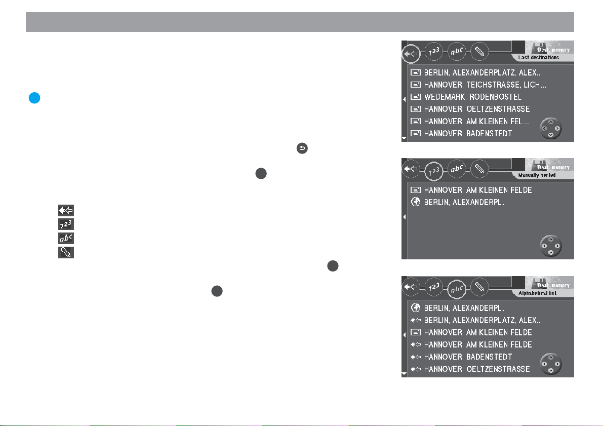
Selecting a destination from the destination memory
Starting point: You are currently in the main menu. If not, press
main menu.
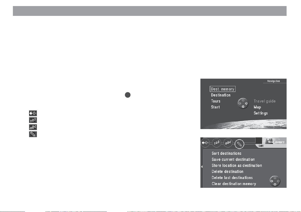
1. Select “Dest. memory” in the main menu. Press OK.
The “Dest. memory” menu will appear. ✔
The icons in the top icon bar represent:
Memory for the last 12 destinations
Individually sorted destination memory
Alphabetically sorted destination memory
Edit destination memory (delete, save and sort destinations)
2. Select the icon of the destination memory you want to use. Press OK.
The destinations saved there will appear. ✔
3. Select the desired destination. Press OK.
A menu containing the data on the current destination will appear. ✔
You will hear the following voice output: “The route is being calculated.” You
can also use this menu to alter the route options.
For more information, read the sections on “Selecting route options” and
“Route guidance”.
to return to the
26
Page 27

Route guidance
There are three display modes available for route guidance. You can choose between
route guidance with arrow symbols, route guidance with map display, or mixed mode
in which both the map and symbols are displayed.
Plus Point: Regardless of which display mode you choose, a friendly voice
will always remind you when it is time to make a turn.
After you have started route guidance and the route has been calculated, route guidance will begin using the display mode selected last.
Starting route guidance
Once you have entered your destination, you can start route guidance.
1. Mark the icon and press the OK button.
A menu containing the data for the configured destination is displayed. ✔
You will hear the following voice output: “The route is being calculated”. As
soon as the route is calculated, the system will provide the first driving recommendation displayed on-screen and as spoken information.
Restarting interrupted route guidance
Plus Point: If you interrupt route guidance, to take a longer break, for example, you can restart route guidance conveniently from the main menu.
The main menu is currently active.
1. Mark “Start”. Press OK.
The route will be calculated and a menu containing the data on the destination selected will appear. ✔
Allgemeines Kurzanlei- TourenZieleingabe Zielspeicher Einstellun-
27
Anhang
Page 28

Route guidance
Adjusting the volume of the voice output
1. To adjust the volume of the voice output for the spoken recommendations,
press or .
A window in which you can adjust the volume will appear. ✔
2. Use to adjust the volume. Press OK.
You will now hear the spoken recommendations at this volume. ✔
Requesting destination and route information
After the route has been calculated, you can request destination and route information. Destination information consists of the complete destination address, the estimated driving time and the distance to the destination.
1. While route guidance is active, press the
The “Info” menu will appear. ✔
2. Press the -key briefly during route guidance to have the last spoken driv-
ing recommendation repeated.
Viewing the route list
The route list lists the streets you are travelling on or will travel on.
Note
The route list is updated regularly as you travel; it will indicate the road
sections which still lie ahead. When a longer route has been calculated
using the option of avoiding motorways, motorway sections might still
appear on the list. As you approach this area, however, these sections
will be deleted from the list.
1. Mark
The route list will appear. ✔
on the top line of the “Info” menu. Press OK.
-key for longer than 2 seconds.
28
Page 29
Route guidance
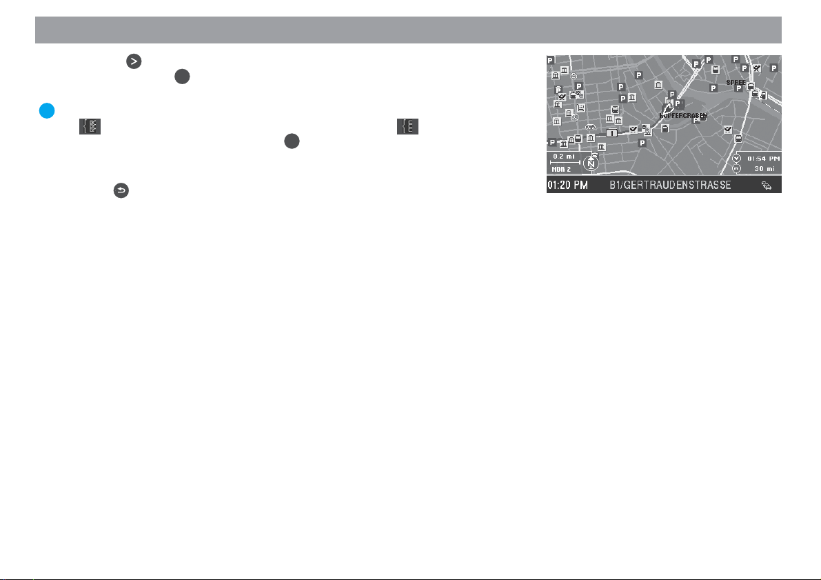
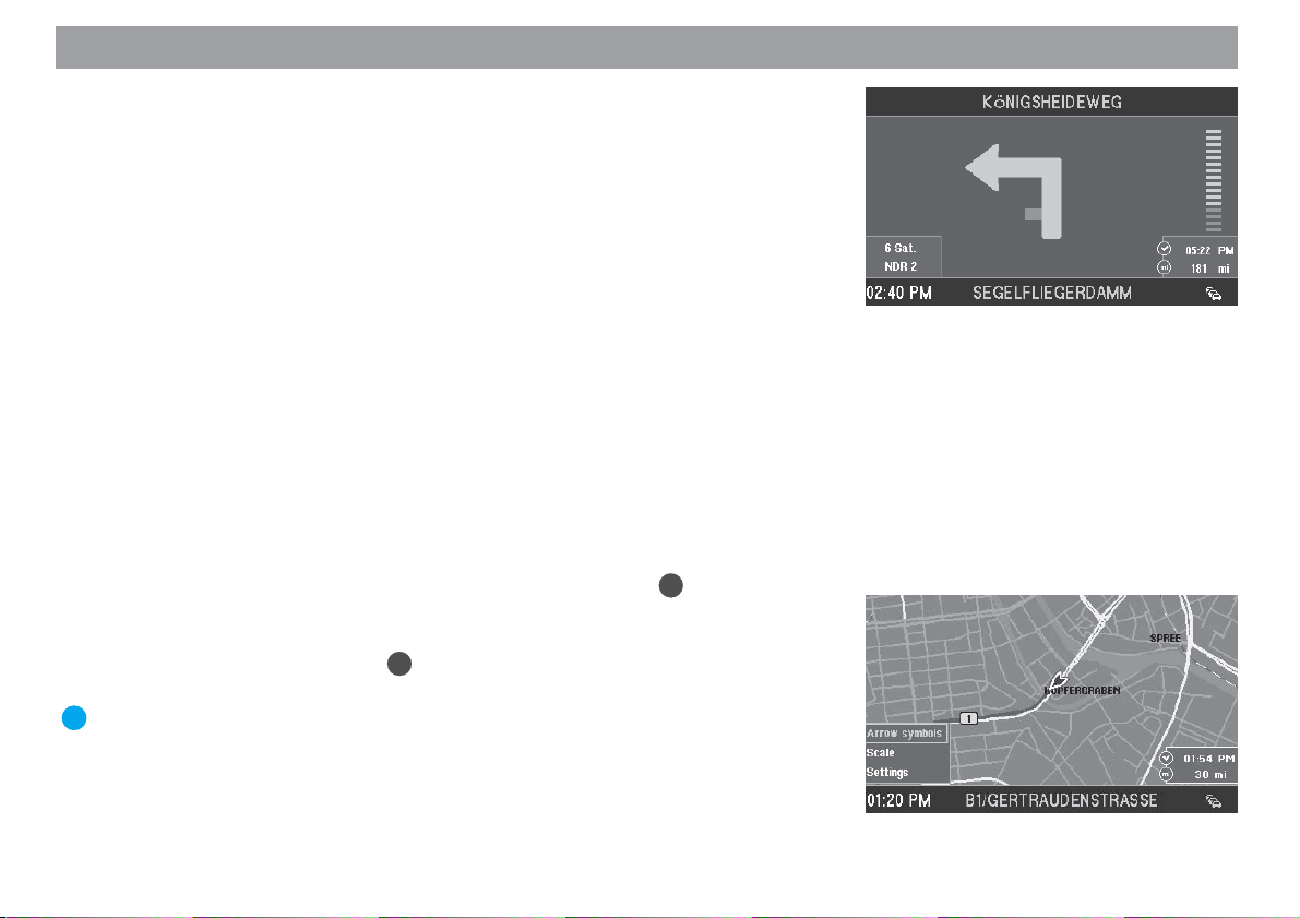
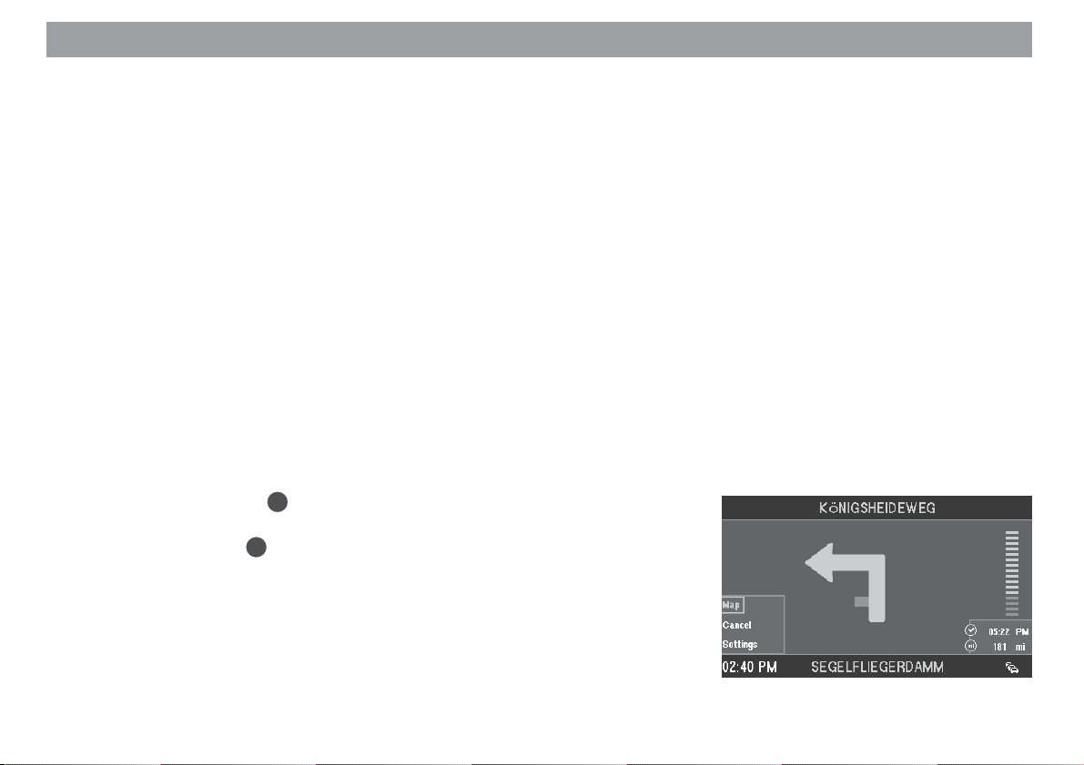
Route guidance in the arrow symbols mode
During route guidance with visual driving recommendations, the system will display
arrow symbols that provide a graphical representation of the spoken driving recommendations. In addition, the following information will be shown in the symbol display:
1 Arrow symbol
2 Distance to destination
3 Travel time or arrival time
4 Name of the road being driven down
5 Name of the next suggested road into which you should turn
6 Distance bar indicating the distance to the turning point
7 TMC station name (in this case NDR 2)
8 Time
9 Number of receivable satellites
: Status display for the TMC function
Activating the symbol display mode
1. To switch from the map display to the symbol display, press OK during the
map display.
A selection menu will appear on the bottom left edge of the display. ✔
2. Mark “Arrow symbols”. Press OK.
Route guidance will continue using the arrow symbols. ✔
Plus Point: When you open the selection menu, the last function selected is
always marked.
99
9
99
77
7
77
88
8
88
55
5
55
11
1
11
44
4
44
33
3
33
22
2
22
66
6
66
::
:
::
Allgemeines Kurzanlei- TourenZieleingabe Zielspeicher Einstellun-
29
Anhang
Page 30
Route guidance
Route guidance with map display
When you use route guidance with the map display, you can select a map showing
your position surroundings (current vehicle position) or the destination surroundings.
The map showing your position surroundings changes in its alignment to indicate your
driving direction (“Automatic”) or can be made to point due north. In addition, you can
select map display with “Junction zoom”. This means that the small scale used during
route guidance, e.g. 0.5 mi, will automatically switch to a larger scale, e.g. 0.1 mi,
when you approach a junction. After you have completed the turn, the map will automatically revert to the scale used previously.
In addition, you can also conveniently select an overview map to show the entire
route.
In each of the different map modes, it is also possible to display other additional information, such as driving time, driving distance, petrol stations, car parks and tourist
attractions.
For more information on route guidance with map display, refer to the “Quick Reference”, “Example of route guidance with map display”.
Activating the map display
1. If route guidance last used the arrow symbols mode, you can easily switch to
OK
the map mode. Press
A selection menu will appear on the bottom left edge of the display. ✔
2. Mark “Map”. Press OK.
Route guidance will continue in map mode. ✔
during the arrow symbols mode.
30
Page 31
Route guidance
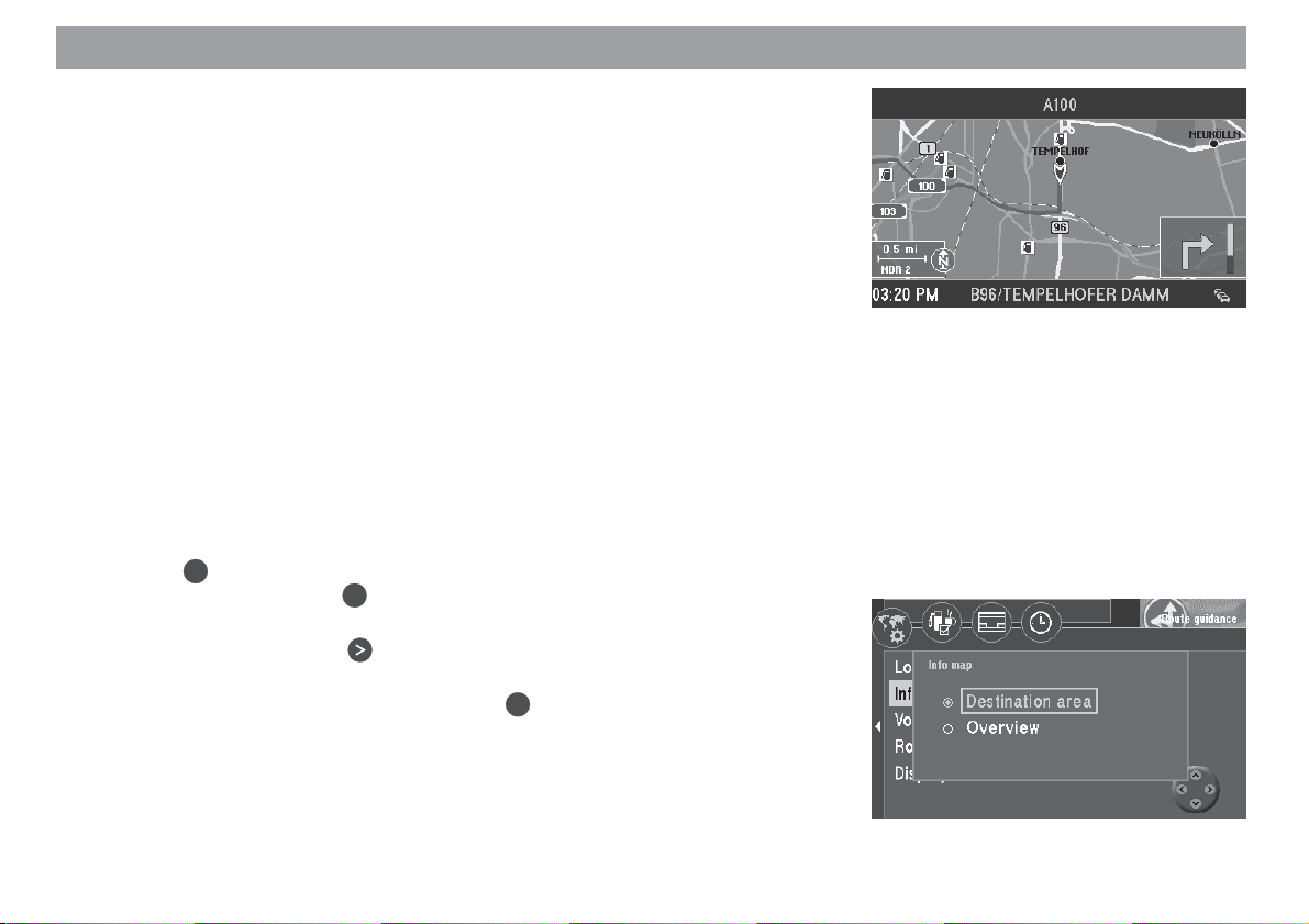
Overview
1 Driving direction arrow indicates the vehicle position and the direction in
which you are travelling.
2 Right-hand information window containing the remaining travel time / arrival
time, distance to the destination and - when coming up to a suggested turning - the arrow symbol and distance bar.
3 Left-hand information window containing the map scale, TMC station name
and compass rose.
4 The calculated route is indicated in colour on the map display.
5 Name of the road being driven down, time and status display of the TMC
traffic congestion function.
6 Name of the next suggested road into which you should turn.
7 Map information (car parks, petrol station, etc.)
Selecting the information map (Destination area, Overview)
You can activate an information map for the destination area or an overview map for
the entire route.
1. Press OK to open the selection menu.
Select “Settings”. Press OK.
The “Settings” menu will appear. ✔
2. Select “Info map”. Press
A selection list for the type of information to be displayed will appear. ✔
3. Select the desired information map. Press OK.
Route guidance will continue using the information map selected. ✔
.
33
3
33
44
4
44
77
7
77
11
1
11
66
6
66
22
2
22
55
5
55
Allgemeines Kurzanlei- TourenZieleingabe Zielspeicher Einstellun-
31
Anhang
Page 32

Route guidance
Selecting the current position map (North, Automatic, Junction zoom)
There are three different display modes for the current position map:
– Map due north (“North”),
– Map in driving direction (“Automatic”) and
– Map in driving direction or due north (depending on the scale), map scale is
adjusted accordingly (“Junction zoom”).
Plus Point: If the “Junction zoom” mode is set, the map scale will automati-
cally zoom into the junction before a turning-off point.
1. Press OK to open the selection menu.
OK
Select “Settings”. Press
The “Settings” menu will appear. ✔
2. Select “Location map”. Press .
A selection list for the type of information to be displayed will appear. ✔
3. Mark the desired display mode. Press OK.
Route guidance will continue with the map selected. ✔
Adjusting the map scale
The map scale can be selected freely for every map. Scales ranging from 0.05 mi to
500 mi are available. This means that one centimetre on the display can represent a
distance of between 0.05 mi and 500 mi.
OK
1. Press
to open the selection menu.
Select “Scale”. Press OK.
The “Change scale” menu will open. ✔
2. Use to select the desired scale. Press OK.
The map will appear in the new scale. ✔
Plus Point: You can also use directly in the map display to alter the
scale.
.
32
Page 33

Route guidance
Information on the map
You can also have such additional information as car parks and petrol stations displayed in symbol form on the map.
The following information can also be displayed on the map:
Exhibition centre Motorway exit Motorway service st.
Car rental Train station Shopping centre
Ferry Airport Restaurant
Border crossing Hotel Hospital
Authorities Car park Police station
Post office Places of interest Other destination
Sport facilities Petrol station Theatre/Culture
Car mechanics
Plus Point: You can select car mechanics for your make of vehicle.
1. Press OK to open the selection menu.
Select “Settings”. Press OK.
The “Settings” menu will appear. ✔
2. Select . Press OK.
A list of the available information will appear. ✔
OK
3. Mark the information you want displayed on the map. Press
lection.
A “checkmark” should appear in front of every type of information you want
displayed. ✔
Plus Point: If you like, on the right side of the menu you can optionally display all the information at the same time (
do so, select the corresponding icon.
4. Once you have selected all the information you want displayed on the map,
mark the “OK” menu item.
5. Press OK.
The map displaying the information selected will appear. ✔
icon) or hide it ( icon). To
Allgemeines Kurzanlei- TourenZieleingabe Zielspeicher Einstellun-
for each se-
33
Anhang
Page 34

Route guidance
Selecting the map display
You can choose the following map display options:
– Map with information window.
– Pure map display.
– Mix mode: The map display, symbol display and information window are
shown on-screen all at the same time.
Plus Point: In mix mode, you do not have to worry that you will not be able to
see some of the map information, since the symbol display is superimposed
transparently on the map.
OK
1. Press the
Select “Settings”. Press the OK button.
The “Settings” menu appears. ✔
2. Mark the icon. Press the OK button.
A selection of the available display modes is shown. ✔
3. Mark the display mode that you want for the map. Press the OK button.
The display mode that will be set is indicated by a dot. ✔
4. On the right side of the menu, mark the “OK” menu item and press the
button.
The map is displayed with the required information windows. ✔
Note
The overview map cannot be displayed in mix mode.
button to open the drop-down menu.
34
OK
Page 35

Route guidance
Selecting driving time or time of arrival
You can choose whether to have the travel time or arrival time displayed in the right
information window.
1. Press OK to open the drop-down menu.
Mark “Settings”. Press OK.
The “Settings” menu will appear. ✔
2. Mark . Press OK.
The “Clock” selection menu will appear. ✔
3. Select “Time info”. Press OK.
The menu for the selection of the display type will appear. ✔
4. Press to select the desired display type. Press OK.
The display type selected will appear next to the menu item. ✔
5. Press
Selecting the automatic/day/night display mode
You can set the TravelPilot DX-V’s display to automatic, day or night mode.
1. Press the
Mark “Settings”. Press the
The “Settings” menu appears. ✔
2. Mark “Display”. Press the OK button.
A selection of display modes appears. ✔
3. Select the required mode. Press the OK button.
The mode is changed. ✔
Plus Point: If you selected the “Automatic” setting, the display will switch to
night-time mode as soon as the vehicle lights are turned on (provided that
the illumination connection is connected).
to exit the menu.
OK
button to open the drop-down menu.
OK
button.
Allgemeines Kurzanlei- TourenZieleingabe Zielspeicher Einstellun-
35
Anhang
Page 36

Route guidance
Using the traffic congestion function
Regardless of whether or not your TravelPilot DX-V is able to receive information from
a TMC source (“TMC D-Namic tuner box” or appropriately equipped Blaupunkt car
radio), you can enter a traffic congestion detour manually. As a result, you can alter
your route quickly on the basis of the traffic situation (e.g. road works, closed sections
of road, etc.). The TravelPilot DX-V will then calculate a new route to bypass the traffic
congestion. In order to do this, you must know the distance of the beginning and the
end of the traffic congestion from your current position. You can also exclude entire
roads from the route list.
Activating the traffic congestion function
1. To activate the traffic congestion function, press ! on the remote control
while route guidance is in progress. The “Congestion” menu will appear. ✔
2. Mark . Press OK.
The “Congestion” menu for manual entries will appear. ✔
3. Select “Congestion ahead”. Press OK.
A menu in which you can enter the beginning and the end of the traffic congestion will appear. ✔
4. Press the button to mark the lower value. This value is used for setting
the distance from your vehicle position to the start of the traffic congestion.
Use the
distance of the beginning of the traffic congestion from your vehicle position.
The distances you can set are dependent on the course of the navigation
route.
5. Press the
the distance from your vehicle position to the end of the traffic congestion.
Use the buttons to set the distance to the end of the traffic congestion.
6. Press the OK button. The icon is marked.
7. Press the OK button again. Route guidance is displayed and you will hear
the following voice output: “The route is being calculated”. ✔
buttons on the remote control to move the arrow to set the
button to mark the upper value. This value is used for setting
36
Page 37

Route guidance
Cancelling a traffic congestion detour
1. If the traffic situation improves, you can cancel a traffic congestion detour. In
the “Congestion” menu for manual entries, mark the menu item “Cancel ‘congestion ahead’ option”. Press OK.
Route guidance will appear, you will hear the following voice output: “The
route is being calculated.” ✔
Excluding roads/road sections from the route list
1. You can also exclude entire roads from the route list. In the “Congestion”
menu for manual entries, mark the menu item “Exclude in route list”.
OK
Press
The route list will appear. ✔
2. Mark the first road you would like to exclude from the route list. Press
If you want to exclude one road only, then do not mark any others and press
OK
If you want to exclude several roads, move the selection bar to the last road.
Press
Route guidance will appear, you will hear the following voice output: “The
route is being calculated.” ✔
Plus Point: For longer roads you can also exclude certain sections, e.g. between two junctions. Roads which can be excluded in sections are marked
by an arrow pointing to the right.
3. To exclude road sections, mark the road and press .
The road sections will appear. ✔
4. Exclude the road sections in the same way as described for roads.
.
indicates that the road marked is excluded from the route list. ✔
again.
OK
.
OK
.
Allgemeines Kurzanlei- TourenZieleingabe Zielspeicher Einstellun-
37
Anhang
Page 38

Route guidance
Cancelling road exclusions on the route list
1. If the traffic situation has improved, you can cancel road exclusions you have
entered in the route list. Mark “Cancel exclusion option” in the “Congestion”
menu. Press OK.
Route guidance will appear, you will hear the following voice output: “The
route is being calculated.” ✔
38
Page 39

Dynamic route guidance with TMC
The TMC function on the TravelPilot DX-V enables the system to use dynamic route
guidance (currently only in Germany and in the Netherlands) to avoid traffic congestion. The TravelPilot DX-V analyses incoming TMC traffic messages, adapts the
planned route to the current traffic situation, and displays traffic reports symbolically
on the map display.
Plus Point: The TravelPilot DX-V always calculates the optimum route in
terms of travelling time; i.e. if a detour around traffic congestion increases
travelling time significantly, the TravelPilot DX-V would remain on the route
passing through the traffic congestion under certain conditions. This depends on what kind of traffic congestion has been reported and how long it is
and on how long the possible detour is.
Dynamic route guidance is only possible when the TravelPilot DX-V is connected to a
TMC receiver.
TMC receivers include the “TMC D-Namic tuner box”, which was specially developed
for the TravelPilot DX-V, and a number of Blaupunkt car radios.
Please contact your authorized Blaupunkt dealer or ring the Blaupunkt telephone hotline (the hotline number is listed on the last page of this instruction manual) to find out
which Blaupunkt car radios can be used in conjunction with the TravelPilot DX-V.
Plus Point: If you have neither a “TMC D-Namic tuner box” nor a suitable
Blaupunkt car radio, you can still enter traffic congestion detours manually.
For more information, refer to the section on “Route guidance”, “Using the
traffic congestion function”.
Allgemeines Kurzanlei- TourenZieleingabe Zielspeicher Einstellun-
39
Anhang
Page 40

Dynamic route guidance with TMC
Switching TMC on/off
The TMC function is switched on or off in the Route options menu.
For more information, refer to the section on “Selecting route options”.
Note
If the TMC function is switched on, the options for “Fast route”, “Motorway”, “Ferry” and “Toll” will be selected automatically in the menu. If
you switch off one of these options, the TMC function will switch off automatically as well.
Selecting the TMC station with the TMC D-Namic tuner box
The “TMC D-Namic tuner box” automatically searches the frequency band in the background for TMC stations within reception range. The TMC stations within reception
range appear in a list which is updated continually.
You can select a TMC station from this list.
!
1. Press
The “Congestion” menu will appear. ✔
2. Select “TMC station list”. Press OK.
The TMC station list will appear. ✔
Note
If there are no TMC stations available, you will hear a beep.
3. Select the TMC station. Press OK.
The “Congestion” menu will appear. The TMC station currently selected will
be displayed next to the menu item. ✔
Plus Point: The “TMC D-Namic tuner box” will automatically tune into the
TMC station you have selected (preferred station). This means that after you
leave the reception area served by your preferred station (the system will
tune into a different TMC station) and return to this reception area again later, this is the station that will be selected even if other TMC stations are
on the remote control unit.
40
Page 41

Dynamic route guidance with TMC
available. This intelligent switching function means that the station indication
may change frequently in the reception area as well. This ensures that you
always receive all of the traffic information which is transmitted by the TMC
stations within reception range.
Selecting the TMC station with the car radio
A TMC-enabled car radio is able to provide traffic information to the TravelPilot DX-V.
1. Press ! on the remote control.
The “Congestion” menu will appear. ✔
2. Select “TMC search”. Press OK.
The TMC seek tuning function for the car radio will begin. ✔
The seek tuning function will stop at the first TMC station within reception
range and the station name will appear next to the menu item. ✔
3. If you would like to select a different station, start TMC seek tuning again.
Note
If, during route guidance, you tune into a station on the car radio which
does not transmit TMC data or if you leave the reception area of the TMC
station, dashes will appear in the display in place of the station name. In
this case it will not be possible to receive traffic information. If you want
to receive traffic information, it will be necessary to start TMC seek tuning for the TravelPilot DX-V again.
Allgemeines Kurzanlei- TourenZieleingabe Zielspeicher Einstellun-
41
Anhang
Page 42
Dynamic route guidance with TMC
Calculating the route with TMC while route guidance is in
progress
The traffic messages are transmitted by TMC stations along with their regular programming. If a traffic message affects the route calculated, then a new route to the
selected destination will be calculated automatically. You will hear the following voice
output: “The route is being calculated taking traffic reports into account”.
Note
The TravelPilot DX-V always calculates a time-optimized route. This means
that if the reported traffic problem were to involve too long a detour, the
TravelPilot may decide not to calculate a diversion at all and instead lead
you through the traffic. This behaviour depends on the length and type of
traffic problem and the length of the possible detour.
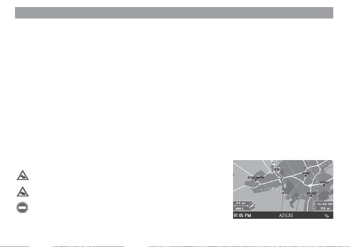
Displaying traffic messages
Displaying on the map
The received traffic messages are displayed on the map using different symbols and
a dashed line. If the traffic obstruction lies along the route calculated by the navigation
system, the traffic congestion symbol is displayed with a blue border.
The following traffic congestion symbols can be displayed on the map:
slow traffic
42
traffic congestion
totally blocked
Page 43

Dynamic route guidance with TMC
Note
The traffic congestion symbols and the dashed line are displayed in red
on the map if they are not relevant to the route (e.g. if on the opposite
carriageway or alongside the route).
Reading as text messages
You can also have all of the traffic information received via TMC displayed. This information will cover an area within a radius of approx. 62 mi around your current vehicle
position.
OK
1. Mark “Display travel information” in the “Congestion” menu. Press
The first TMC traffic message on the list will appear. ✔
The number of the message on display and the total number of messages on
the list will appear on the top line of the menu. Press
through the messages.
Note
If there are no traffic messages in the memory, “No traffic information
available” will appear in the display.
to “page”
.
Allgemeines Kurzanlei- TourenZieleingabe Zielspeicher Einstellun-
43
Anhang
Page 44

Selecting route options
You can select a number of route options for route calculation to meet your individual
needs.
You can always select between the short and the fast route. In addition, you can use
or avoid motorways, toll roads, ferries and switch dynamic route guidance (TMC) on
or off. (For more information on dynamic route guidance, refer to the section on “Dynamic route guidance with TMC”).
Plus Point: You can alter and save the route options for any single route or
for route guidance in general.
Some of the route options are mutually exclusive. Dynamic route guidance, for example, can only be used in conjunction with the options “Fast route”, “Motorway”, “Ferry”
and “Toll”.
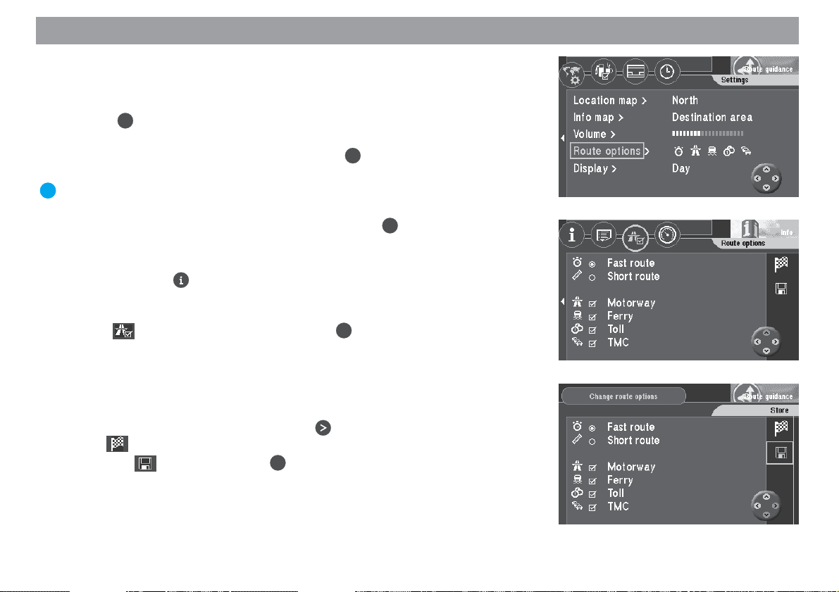
Altering route options prior to route guidance
After you have started route guidance, you will see an information menu containing
data on the current destination, you will also hear the following voice output: “The
route is being calculated.” Now you can alter the route options.
OK
1. When “Change route options” is marked, press
The “Change route options” menu will appear. ✔
The active route option for “Short route” or “Fast route” is marked with a dot.
The other active options are marked with a checkmark.
Activating/deactivating route options
2. Move the selection bar to the option you want to alter. Press
A checkmark will appear or disappear. ✔
3. Mark the icon. Press the OK button.
The route is calculated taking the changed options into account. ✔
.
OK
.
44
Page 45
Selecting route options
Altering the route options while route guidance is in progress
It is possible to alter the route options while route guidance is in progress in the “Settings” menu for route guidance.
1. Press OK while route guidance is in progress.
A selection menu will appear. ✔
2. Select “Settings” in the selection menu. Press OK.
The “Settings” menu will appear. ✔
Plus Point: In the “Settings” menu you can see at a glance which route options are active and which are not.
OK
3. Select “Route options” in the “Settings” menu. Press
The “Change route options” menu will appear. ✔
You can also alter the route options in the “Info” menu.
1. Press down the -key for longer than 2 seconds while route guidance is in
progress.
The “Info” menu will appear. ✔
2. Mark on the top line of the menu. Press OK.
The route options menu will appear. ✔
Saving your settings
Save the currently selected settings if you want to use them for future route guidance.
1. Once you have made the settings, press .
The icon in the menu is marked. ✔
2. Mark the icon and press the OK button.
The route options are saved. ✔
.
Allgemeines Kurzanlei- TourenZieleingabe Zielspeicher Einstellun-
45
Anhang
Page 46
Destination memory
You can use the destination memory to name (for identification purposes) and save
frequently used destinations. You can then retrieve these destinations from a list sorted according to your own criteria or alphabetically. The TravelPilot DX-V also automatically saves the last twelve destinations used. These destinations can be retrieved
from the destination memory for route guidance and you can identify them with a short
name and save them.
For more information on how to use destinations in the destination memory for destination entry, refer to the section on “Entering destinations”, “Destinations in the destination memory”.
Accessing the destination memory
From the main menu:
OK
1. Mark “Dest. memory” in the main menu. Press
The “Dest. memory” menu will appear. ✔
The icons in the top icon bar represent:
Memory for the last 12 destinations
Individually sorted destination memory
Alphabetically sorted destination memory
Edit destination memory (delete, save and sort destinations)
.
46
Page 47
Destination memory
Saving destinations
You can save your current destination or your current vehicle position as a destination.
Saving your current destination with a name
1. Mark in the “Dest. memory” menu. Press OK.
The “Dest. memory - Edit” menu will appear. ✔
2. Mark “Save current destination”. Press OK.
The character set used to enter the destination name will appear. ✔
OK
3. Enter a name for your destination as usual. Mark “OK” and press
The “Store destination” menu will appear. ✔
4. Use to move the name of the destination to the position in which you
would like to save it in the destination memory. Press OK.
The “Dest. memory - Edit” menu will appear again. ✔
.
Allgemeines Kurzanlei- TourenZieleingabe Zielspeicher Einstellun-
47
Anhang
Page 48

Destination memory
Saving your current vehicle position as a destination
Plus Point: It is very convenient to be able to save your current vehicle position as a destination when you get somewhere “en route” that you would like
to return to later. This method also uses the most exact data, so that you can
use route guidance to take you directly to the doorstep, rather than having to
use a junction or house number block.
1. Mark
The “Dest. memory - Edit” menu will appear. ✔
2. Mark “Store location as destination”. Press OK.
The character set used to enter the destination name will appear. ✔
3. Use the character set to enter a name for the destination as usual. Mark
“OK” and press OK.
The “Store destination” menu will appear. ✔
4. Use to move the name of the destination to the position in which you
would like to save it in the destination memory. Press
The “Dest. memory - Edit” menu will appear again. ✔
in the “Dest. memory” menu. Press OK.
OK
.
48
Page 49
Destination memory
Deleting destinations from the destination memory
You can delete individual destinations, the last destinations and clear the entire destination memory.
Deleting a single destination
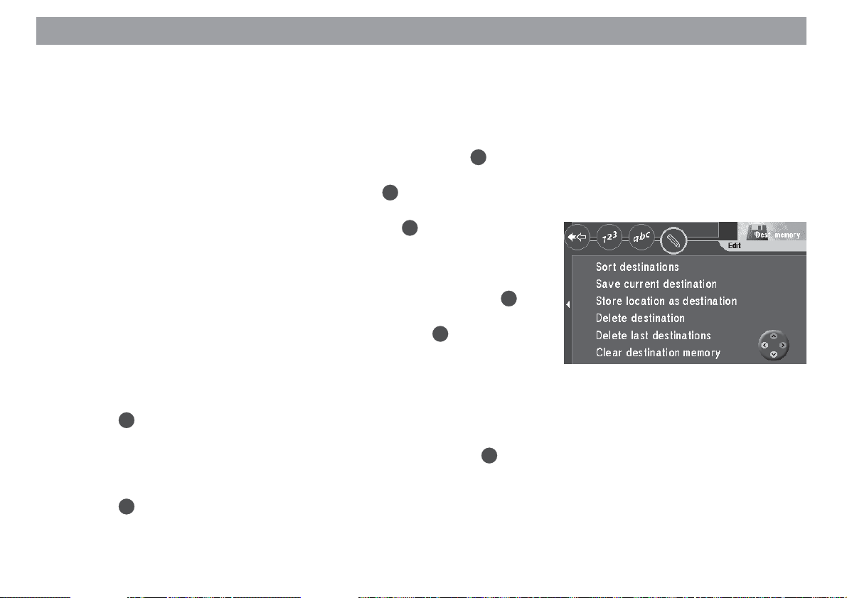
1. Mark “Delete destination” in the “Dest. memory - Edit” menu. Press OK.
The “Delete destination” menu will appear. ✔
2. Mark the destination you would like to delete. Press OK.
A pop-up inquiry requiring confirmation will appear. ✔
OK
3. If you want to delete the destination, mark “Yes”. Press
The “Dest. memory - Edit” menu will appear again. ✔
Deleting the last destinations
1. Mark “Delete last destinations” in the “Dest. memory - Edit” menu. Press OK.
A pop-up inquiry requiring confirmation will appear. ✔
2. If you want to delete the last destinations, mark “Yes”. Press OK.
The “Dest. memory - Edit” menu will appear again. ✔
Clearing the destination memory
1. Mark “Clear destination memory” in the “Dest. memory - Edit” menu.
OK
Press
A pop-up inquiry requiring confirmation will appear. ✔
2. If you want to clear the entire destination memory, mark “Yes”. Press OK.
The “Dest. memory - Edit” menu will appear again. ✔
3. If you do not want to clear the entire destination memory, mark “No”.
Press OK.
The “Dest. memory - Edit” menu will appear again. ✔
.
.
Allgemeines Kurzanlei- TourenZieleingabe Zielspeicher Einstellun-
49
Anhang
Page 50

Destination memory
Sorting the destination memory
You can save all of the destinations identified with a name in any order you choose
(individually sorted destination memory, symbol).
1. Mark “Sort destinations” in the “Dest. memory - Edit” menu. Press OK.
The “Choose destination” menu will appear. ✔
2. Mark the desired destination. Press OK.
3. Use to move the destination to the desired position. Press OK.
The “Dest. memory - Edit” menu will appear again. ✔
50
Page 51

Tour memory
Use the tour memory to combine individual destinations to create a “tour”.
Plus Point: With the help of the tour memory, you can easily plan sightseeing
tours or business trips to customers.
1. To program the tour memory select “Tours” in the main menu. Press OK.
The tour list will appear (if there is no tour list available, the “Tour memory Edit” menu will appear). ✔
Entering tour destinations
There are several ways in which you can enter tour destinations:
– Direct destination input including destinations in the surrounding area, non-
urban destinations, coordinate destinations and destination input using the
map (as described in the chapters entitled “Entering destinations” and “Quick
Reference” - in the section on “Direct destination entry in 10 steps”).
– Retrieving destinations from the destination memory
– Using the last destination used for navigation
Entering new tour destinations
1. To enter a new tour destination, mark “New tour destination” in the “Tour
OK
memory - Edit” menu. Press
The “Destination” menu for the tour memory will appear. ✔
2. Enter a tour destination.
Mark the
Plus Point: Enter the destination in the same way as described for direct
destination entry.
3. Press the
The speller for entering a short name appears. ✔
4. Enter a name in the usual way.
icon.
OK
button.
.
Allgemeines Kurzanlei- TourenZieleingabe Zielspeicher Einstellun-
51
Anhang
Page 52

Tour memory
5. Finally, mark “OK” in the speller and press the OK button.
The “Store destination” menu appears. ✔
6. Move the tour destination to the required position. Press the OK button.
The “Tour memory - Edit” menu appears again. ✔
Retrieving destinations from the destination memory
You can retrieve destinations from the destination memory for the tour memory.
1. To retrieve destinations from the destination memory select from the top
line of the menu. Press OK.
The destinations in the destination memory will appear. ✔
2. Mark the destination you would like to use. Press OK.
The “Store destination” menu for the tour memory will appear. ✔
OK
3. Move the tour destination to the desired position. Press
The tour list will appear. ✔
Using the last destination used for navigation
1. To use the last (current) destination used for navigation, select from the
top line in the tour memory. Press OK.
The “Tour memory - Edit” menu will appear. ✔
2. Select “Insert current destination”. Press OK.
The character set used to enter a destination name will appear. ✔
3. Enter a name for the destination.
The “Store destination” menu for the tour memory will appear. ✔
4. Move the tour destination to the desired position on the tour list. Press
The “Tour memory - Edit” menu will appear. ✔
.
OK
.
52
Page 53

Tour memory
Sorting the tour list
1. If you would like to re-sort the tour list, mark on the top line of the tour
memory. Press OK.
The “Tour memory - Edit” menu will appear. ✔
2. Select “Sort tour”. Press OK.
The tour list will appear. ✔
OK
3. Mark the destination you want to move. Press
4. Use
The “Tour memory - Edit” menu will appear. ✔
5. Repeat these steps until the list is in the order you want.
to move the destination to the desired position. Press OK.
Deleting tour destinations
1. If you want to delete a tour destination from the tour list, mark on the top
line of the tour memory. Press OK.
2. Select “Delete tour destination”. Press OK.
The tour list will appear. ✔
3. Select the destination you want to delete. Press OK.
A pop-up inquiry requiring confirmation will appear. ✔
4. Mark “Yes”. Press OK.
The “Tour memory - Edit” menu will appear. ✔
The tour destination will be deleted.
.
Allgemeines Kurzanlei- TourenZieleingabe Zielspeicher Einstellun-
53
Anhang
Page 54

Tour memory
Deleting the whole tour
1. If you would like to delete a tour completely from the tour memory, mark
on the top line of the tour memory. Press OK.
The “Tour memory - Edit” menu will appear. ✔
2. Mark “Delete whole tour”. Press OK.
A pop-up inquiry requiring confirmation will appear. ✔
OK
OK
.
.
3. Mark “Yes”. Press
The “Tour memory - Edit” menu will appear. ✔
Starting route guidance to a tour destination
1. If you want to start route guidance, mark on the top line of the tour
memory. Press
The tour list will appear. ✔
2. Mark the destination on the tour list for which you want to start route guidance. Press OK.
An information menu containing the destination data will appear. ✔
You will hear the following voice output: “The route to your intermediate destination is being calculated.”
After you have reached the first tour destination, route guidance will start automatically to guide you to the next destination on the tour list.
Plus Point: The tour can be started from any destination.
54
Page 55

Travel guides
The additionally available navigation CDs containing travel guides extend the range
of features of your TravelPilot DX-V. The travel guides allow you to select such facilities as hotels and restaurants and to set them as your destination.
Note
The respective editorial offices are responsible for the features and content provided in the travel guides. For further information, please read
the travel guide’s operating instructions.
Plus Point: Using the travel guide and tour function on the TravelPilot DX-V,
you can, for instance, very conveniently plan and go on sight-seeing tours.
All you have to do is store the individual destinations from the travel guide
and add them to the destination memory in the tour memory.
Activating the travel guide
1. Select the “Travel guide” menu item in the main menu. Press the OK button.
The main travel guide menu appears. ✔
Special cases when entering a destination
Entering a place in travel guide mode is different to the normal way you would enter a
destination on the TravelPilot DX-V. The input methods differ as follows:
– all the letters in the input field can always be selected.
– the icon (list symbol) cannot be selected. In order to open the place list,
OK
you have to press the
put field.
– you have to switch to special characters manually. You do so using the
icon.
– the last 20 places that were entered are not saved.
button for a longer period or select “OK” in the in-
Allgemeines Kurzanlei- TourenZieleingabe Zielspeicher Einstellun-
55
Anhang
Page 56

Other functions
Map display without route guidance
While driving without active route guidance, you can use the TravelPilot DX-V to display a map of the surrounding area. This map can display all of the information available for navigation, e.g. parking garages and public facilities. For more information,
refer to the section on “Route guidance”, “Route guidance in map mode”.
1. To use the map mode without route guidance, mark “Map” in the main menu.
OK
Press
A map of the surrounding area will appear. ✔
Plus Point: If the main menu is on display, the system will automatically
switch to the map display after approximately 3 minutes.
Accessing the on-board computer
You can access the integrated on-board computer to display the following data onscreen: travel time since the beginning of the journey, the driven distance, the current
speed, the average speed and the GPS status.
1. Press the button for longer than two seconds.
The “Info” menu appears. ✔
2. Mark the icon in the top menu line. Press the OK button.
The on-board computer’s data are displayed. ✔
You have the option of deleting the displayed values.
3. To do so, mark the icon on the right-hand side. Press the OK button.
The data are deleted and calculation of new data begins immediately thereafter. ✔
.
56
Displaying the GPS status
OK
1. Mark the “GPS status” menu item. Press the
The menu containing the number of receivable satellites and the current vehicle position is displayed. ✔
button.
Page 57

System settings
Accessing the main menu for system settings
The system settings for the TravelPilot DX-V can be altered by selecting the “Settings” menu item in the main menu.
1. Select “Settings” in the main menu. Press OK.
The “Settings” menu will appear. ✔
The “Settings” menu consists of four sub-menus. To access the sub-menus use the
cog icons on the top line of the menu.
Audio/Video settings
Basic settings
Other settings
Calibration settings for the TravelPilot DX-V
Audio/video settings
1. Mark on the top line of the “Settings” menu. Press OK.
The sub-menu for audio/video settings will appear. ✔
Selecting the language
1. To select the language for the menu displays and the voice output, select
OK
“Language”. Press
A list of the available languages will appear. ✔
“Imperial” indicates that the distance is given in miles for English.
2. Select the desired language. Press OK.
The language selected will be loaded for navigation. ✔
.
Allgemeines Kurzanlei- TourenZieleingabe Zielspeicher Einstellun-
57
Anhang
Page 58
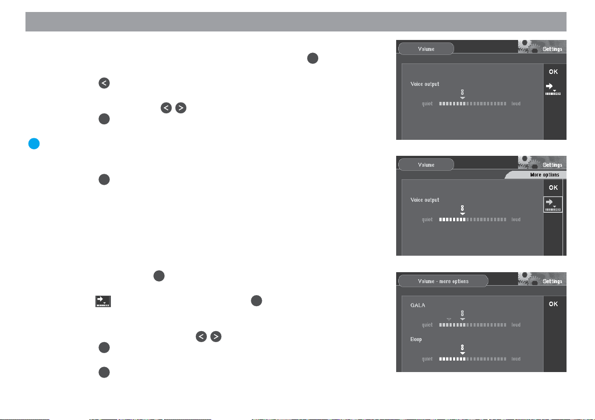
System settings
Adjusting the volume for voice output
1. To adjust the volume for voice output, select “Volume”. Press
A menu allowing you to adjust the volume will appear. ✔
2. Press the
button.
The scale for setting the volume is marked. ✔
3. Set the volume using the buttons on the remote control.
Press the OKbutton.
The “OK” menu item is marked. ✔
Plus Point: While you are adjusting the setting, you will hear a short voice
output each time you alter the volume. As a result, you always know exactly
what volume you have selected.
OK
4. Press the
button again.
The audio/video settings submenu is displayed. ✔
Adjusting additional volume options
It is also possible to individually adjust the volume of the beep and GALA, the speeddependent volume adjustment function. As driving speed increases, the noise level
inside the vehicle increases as well. The volume adjustment function automatically
adjusts the volume of the voice output.
OK
1. Select “Volume”. Press
.
A menu for volume adjustment will appear. ✔
2. Mark the symbol (more options). Press the OK button.
The “Volume - more options” menu is displayed. ✔
3. Move the selection marker to the required volume value that you want to
change. Set the volume using the buttons on the remote control.
OK
Press the
button.
The “OK” menu item is marked. ✔
4. Press the OK button again.
The audio/video settings submenu is displayed. ✔
OK
.
58
Page 59

System settings
Selecting the automatic/day/night display mode
1. To select the display mode, mark “Display”. Press
A menu for the selection of the display mode will appear. ✔
OK
2. Select the desired mode. Press
The mode selected will be activated. ✔
Plus Point: You can also conveniently change the display mode in the route
guidance “Settings” menu. For further information, refer to the section entitled “Selecting the automatic/day/night display mode” in the “Route guidance” chapter.
.
OK
.
Allgemeines Kurzanlei- TourenZieleingabe Zielspeicher Einstellun-
59
Anhang
Page 60
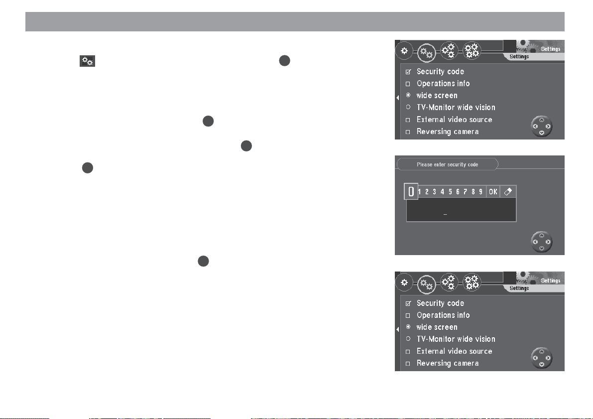
System settings
Basic settings
1. Mark on the top line of the “Settings” menu. Press OK.
The sub-menu for audio/video settings will appear. ✔
Activating/deactivating the security code
1. If you would like to activate or deactivate the security code for the TravelPilot
OK
OK
.
.
DX-V, select “Security code”. Press
A menu in which you must enter the code number will appear. ✔
2. Mark the first digit in the code number. Press OK.
Repeat for the remaining digits in the code number. Then mark “OK” and
press OK.
If you have entered and confirmed an incorrect code by mistake, you will not
be able to repeat your entry until a waiting period has elapsed. During this
period, the TravelPilot DX-V must remain switched on. “SAFE” will appear in
the input field.
Switching the operating introduction on/off
1. If you would like to switch the TravelPilot DX-V operating introduction on or
off, select “Operations info”. Press
The operating introduction is active if it is marked by a checkmark. ✔
60
Page 61
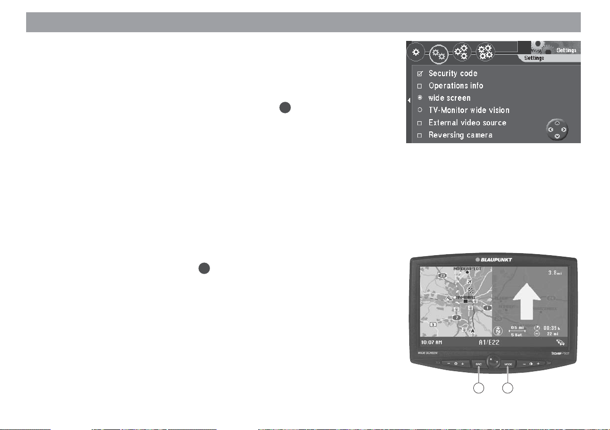
System settings
Selecting a monitor
Depending on the version, the TravelPilot DX-V is supplied with a detachable 16:9
(wide screen) monitor or a retractable 16:9 (wide vision) monitor with an integrated TV
tuner. If you want to use the TravelPilot DX-V to view a TV/video source, you must
first activate the “External video source” option.
1. Select the appropriate monitor version and press the OK button.
The selected monitor is indicated by a filled circle. ✔
Note
The following operating instructions on “Selecting an external video
source”, “Switching to the video source” and “Selecting the display format” only apply to the 16:9 wide screen monitor.
Selecting an external video source
You have the option of connecting a video player or a DVD player using an adapter to
the RGB input of the TravelPilot DX-V. You can find out which adapters are available
for this from your authorised Blaupunkt dealer or from the Blaupunkt telephone hotline.
1. If you want to connect an external video source, select the “External video
OK
source” menu item and press the
The external video source is activated if it appears with a tick mark alongside
it. ✔
Switching to the video source
You can switch to the external video signal on the 16:9 wide screen monitor. The
external video signal can only be watched whilst the vehicle is stationary or is not
moving any faster than 4 mph.
1. Press the SRC button 4 on the monitor to switch between navigation mode
and the external video source.
button.
4 6
Allgemeines Kurzanlei- TourenZieleingabe Zielspeicher Einstellun-
61
Anhang
Page 62
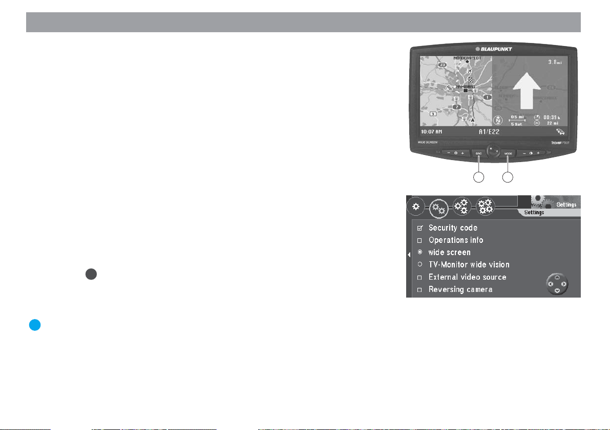
System settings
Selecting the display format
You have the option of changing the display format for playing the external video
source.
1. Keep pressing the MODE button 6 until the required format is set.
Selection takes place in the following order:
Normal ➨ Cinema ➨ Full ➨ Normal ➨ …
Notes
The system does not allow you to switch modes in navigation mode. The
navigation display is always shown in full mode.
The selected mode can be configured and saved separately for the reversing camera and the external video source.
Activating the reversing camera
A special adapter is required to connect a reversing camera. Please contact your
authorized Blaupunkt dealer or ring the Blaupunkt telephone hotline to find out which
adapters are available.
1. If you use a reversing camera and want the picture provided by this camera
shown on the TravelPilot DX-V display, select “Reversing camera”.
OK
Press
The reversing camera input is active if it is marked by a checkmark. ✔
If connected properly, the reversing camera picture will appear automatically as soon
as you put the car into reverse gear.
Plus Point: If you use the 16:9 wide screen monitor together with the reversing camera, the picture will be displayed horizontally inversed. This gives the
same visual impression as when using the rear-view mirror.
.
62
4 6
Page 63
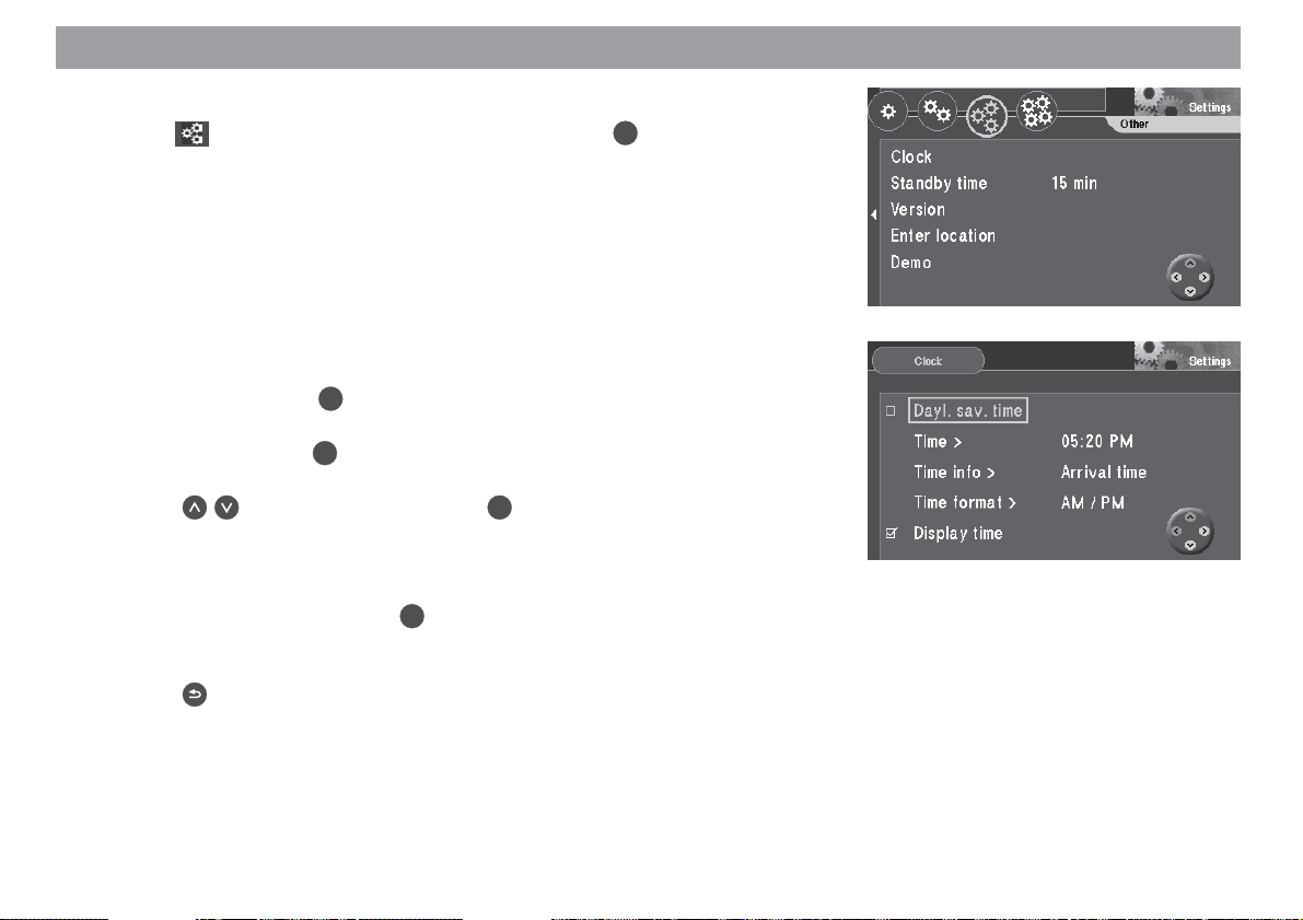
System settings
Other settings
1. Mark on the top line of the “Settings” menu. Press OK.
The sub-menu for other settings will appear. ✔
Setting the clock
You can set daylight-savings time, the current time, the display of the arrival or driving
time and select the time display format as well.
The current time is automatically set via the GPS signal. This is, however, a time
difference of one hour compared to Central European Time (CET) because GPS transmits world time UTC. To make sure that the TravelPilot DX-V operates properly, it will
be necessary to correct this time difference manually.
OK
1. Select “Clock”. Press
The “Clock” menu will appear. ✔
2. Select “Time”. Press OK.
A menu to set the time will appear. ✔
3. Press to set the local time. Press OK.
The local time set will appear beside the menu item. ✔
The clock will not switch to daylight-savings time or standard time automatically; this
adjustment must be made manually.
4. Select “Dayl. sav. time”. Press
Daylight-savings time has been selected when there is a checkmark next to
the menu item. ✔
5. Press to exit the menu.
.
OK
.
Allgemeines Kurzanlei- TourenZieleingabe Zielspeicher Einstellun-
63
Anhang
Page 64

System settings
Selecting the display of driving or arrival time
During route guidance, you can have the driving time or time of arrival displayed.
1. Select “Clock”. Press
The “Clock” menu will appear. ✔
2. Select “Time info”. Press OK.
The menu for the selection of the display type will appear. ✔
3. Press
The display type selected will appear next to the menu item. ✔
4. Press to exit the menu.
Selecting the time format
You can have the time displayed using a 12 or 24-hour format.
1. Select “Clock”. Press OK.
The “Clock” menu will appear. ✔
2. Select “Time format”. Press OK.
The menu for the selection of the time format will appear. ✔
3. Press to select the desired time format. Press OK.
The time format selected will appear next to the menu item. ✔
4. Press to exit the menu.
to select the desired display type. Press OK.
OK
.
64
Page 65

System settings
Selecting the clock display
You have the option of switching the clock display on/off in the bottom line of the
monitor.
1. Select the “Display time” menu item. Press the OK button.
The clock display is switched on if a small tick mark appears alongside the
menu item. ✔
Setting the standby time
You can select the amount of time that the TravelPilot DX-V will remain active after
you have switched off the ignition. The standby times available are 0, 15, 30 and 45
minutes.
OK
1. Select “Standby time”. Press
A menu for the selection of the standby time will appear. ✔
2. Select the desired standby time. Press OK.
The standby time selected will appear next to the menu item. ✔
Displaying the system version
1. To display the system version, select “Version”. Press OK.
The current system versions will appear. ✔
2. Press to exit the menu.
Entering your current vehicle position manually
1. If you would like to enter your current vehicle position manually, select “Enter
OK
location”. Press
A selection menu will appear. ✔
2. Select the entry mode via town or map. Press OK.
Plus Point: The entry is made in the same way as described for entering a
destination.
.
.
Allgemeines Kurzanlei- TourenZieleingabe Zielspeicher Einstellun-
65
Anhang
Page 66

System settings
3. After you have entered the city/town, the street and the junction, you still
have to set the direction and the distance from the junction to your vehicle
position. Select the corresponding menu item and use to enter the in-
OK
formation. Then mark “OK” and press
Activating the demonstration mode
You can use the TravelPilot DX-V to simulate route guidance.
1. If you would like to activate the demonstration mode, select “Demo”.
Press OK.
A selection menu will appear. ✔
2. Select either the simple demonstration mode (“Normal”) or a constant repeat
(“Autorepeat”). Press OK.
Navigation will be reloaded. ✔
Note
Destinations and tours programmed during the demonstration mode will
not be saved in the destination memory when the demonstration mode
has ended.
The demonstration mode remains active until the TravelPilot DX-V is restarted or until it is deactivated.
Deactivating the demonstration mode
1. If you would like to deactivate the demonstration mode, select
“Settings” menu. Press OK.
The sub-menu for other settings will appear. ✔
2. Select “Navigation”. Press OK.
Navigation will be reloaded. ✔
.
in the
66
Page 67

System settings
Calibration settings
1. Mark on the top line of the “Settings” menu. Press OK.
The sub-menu for calibration will appear. ✔
Calibration after changing the tyres
When the car tyres are changed, from summer to winter tyres for example, it might be
necessary to calibrate the TravelPilot DX-V again.
1. Select “Tyre change”. Press OK.
A warning note will appear. ✔
OK
2. If you want to calibrate the system, select “Continue” and press
As soon as you begin driving, the TravelPilot DX-V will begin to update the
calibration information stored.
This process is displayed in a status window. ✔
Installing the system again
If the TravelPilot DX-V is installed in a different vehicle, the entire calibration process
must be performed again.
OK
1. Select “New installation”. Press
A warning note will appear. ✔
2. If you want to recalibrate the system, select “Continue” and press the
OK
button.
All the calibration data are deleted. ✔
3. As soon as you begin driving, the TravelPilot will begin to calibrate the system.
This process is displayed in a status window. ✔
.
.
Allgemeines Kurzanlei- TourenZieleingabe Zielspeicher Einstellun-
67
Anhang
Page 68

System settings
Displaying the calibration status
You can display the status of your system calibration.
1. Select “Status”. Press
A window indicating the current calibration status will appear. ✔
The status information is indicated in percent.
Manual calibration
You can also calibrate the TravelPilot DX-V manually. To do so, you have to drive a
distance of at least 110 yd at a speed of not more than 20 mph. Please note that you
should use as accurate a driving distance as possible.
1. Select “Manual”. Press
Now you will be instructed to enter the distance you intend to drive. ✔
2. Press
on the remote control unit to enter the first digit. Press OK.
3. Mark the remaining digits one after the other and press
digit.
4. Press OK for a longer time to confirm your entry.
Now you will be instructed to drive the distance entered. ✔
5. Follow the other instructions on the screen.
OK
OK
.
.
OK
to confirm each
68
Page 69
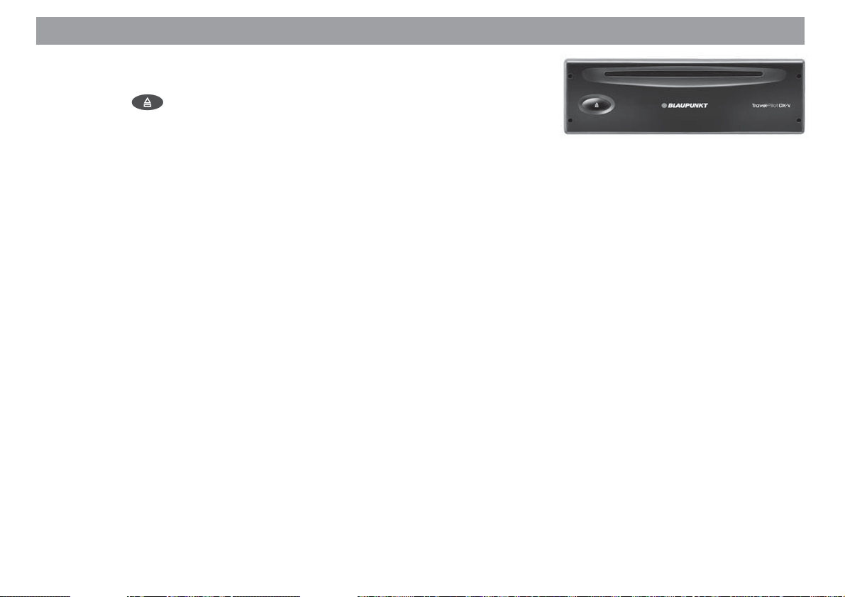
Appendix
Changing the navigation CD-ROM
The CD-ROM cannot be changed unless the vehicle is stationary. To remove the CDROM press the button. The CD-ROM will eject. With the label facing up, insert
the new CD-ROM carefully into the CD slot until it is pulled into the CD player automatically.
Compatible navigation CD-ROMs
The TravelPilot DX-V can only be used with navigation CD-ROMs that are labelled
with a “DX”. If no CD-ROM is inserted in the unit, a message informing you of this
appears in the display.
Note
The navigation system is not designed for use with CD-ROMs that you
have burned yourself. Any faults or limitations to navigation performance as a result of this are not covered by the guarantee.
Care tips for CD-ROMs
If a CD-ROM becomes dirty, never clean it using a circular motion but always from its
centre to its outer edge using a soft lint-free cloth. If the CD is very dirty, we recommend you wash the CD using standard washing-up liquid. Again, when washing the
CD, never clean it using a circular motion but wipe it from its centre to its outer edge
and leave it to dry.
We also recommend that you handle both the under and upper sides of the CD with
care, since the structure of the CD is such that the information layer is located directly
beneath the printed layer (i.e. label side).
Allgemeines Kurzanlei- TourenZieleingabe Zielspeicher Einstellun-
69
Anhang
Page 70

Appendix
Some comments regarding questions on reading quality:
A dirty or damaged CD can lead to difficulties when reading the CD. The severity of
the reading error depends on the amount of dirt present and the severity of the physical damage. Severe scratches cause “read errors (data errors)”, which lead to the CD
jumping or getting stuck during playback. All CDs must be handled with care and
always stored in a protective case.
Available navigation CD-ROMs
Precise routes to your destination
The navigation CDs know the roads right down to the last detail; in many cities, it is
even possible to select house numbers. The informative map displays your destination. Other convenient features include traffic congestion display, ferry connections
and many destinations which can be selected directly, such as airports, car parks,
petrol stations, etc. The following CDs are currently available:
Germany Plus - Benelux - Great Britain - Netherlands - Belgium/Luxembourg - Austria
- Switzerland - France - Italy - Spain - Portugal - Scandinavia
Available travel guide CD-ROMs
Expert information
In addition to the road network, the travel guide CDs contain a wide variety of hotels,
restaurants, tourist attractions, and much more. Detailed information can be selected
according to distance away, price class, credit cards, etc. The following travel guide
CDs are currently available:
Tele Atlas/Michelin Germany - Tele Atlas/Varta Guide Germany - Merian Scout Germany - MerianScout Germany Golf Special - Tele Atlas/Michelin Belgium, Luxembourg - Merian Scout Austria - Merian Scout Switzerland - Tele Atlas/ANWB Netherlands - Tele Atlas/Michelin France - Tele Atlas/De Agostini Italy
70
Page 71

Wide screen monitor settings
The display brightness, the contrast, the brightness of the keypad illumination and the
display on/off switch are all controlled at the front of the monitor. You also have the
option of resetting the monitor back to its factory defaults.
Adjusting the display brightness
The display brightness is adjusted by way of a phototransistor 8 on the front cover
as well as the left-hand +/- rocker switch 3.
1. Press the +/- rocker switch 3 to set the brightness to suit your personal
preferences. The selected setting is stored automatically.
Switching the monitor on/off
You can switch the display off whilst the system is running by pressing the ON button
5. The loudspeaker, the infrared receiver and the keypad illumination remain active.
1. Press the ON button 5 on the monitor. The display is switched on/off.
Note
If the whole system is switched off and on again by the vehicle ignition,
the display will be switched on as well.
Adjusting the contrast
You can optimize the display contrast using the right-hand +/- rocker switch 7.
1. Press the +/- rocker switch 7 to set the contrast to suit your personal pref-
erences. The selected setting is stored automatically.
2 3 41 6 7 85
Allgemeines Kurzanlei- TourenZieleingabe Zielspeicher Einstellun-
71
Anhang
Page 72

Wide screen monitor settings
Setting the brightness of the keypad illumination
You can set the keypad brightness independently of the display brightness.
1. Press the “+” on both rocker switches 3 and 7 simultaneously. ✔
The keypad illumination gets brighter.
2. Press the “-” on both rocker switches 3 and 7 simultaneously.
The keypad illumination gets darker. ✔
Resetting to the factory defaults
You can reset the following functions to their factory defaults by simultaneously pressing
the “-” on the rocker switch 3 and the “+” on the rocker switch 7 whilst the monitor
is switched on.
– Keypad illumination
– Display brightness
– Contrast
– Navigation display in full mode
– Mode memory for external video picture and reversing mirror to normal mode
72
2 3 41 6 7 85
Page 73

Index
A
Accessing the destination memory .....46
Activating the demonstration mode..... 66
Activating the map display ..................30
Activating the reversing camera.......... 62
Activating the symbol display mode ....29
Activating the traffic congestion
function ............................................ 36
Activating the travel guide ...................55
Activating/deactivating route options .. 44
Activating/deactivating the security
code .................................................60
Adjusting additional volume options.... 58
Adjusting the contrast..........................71
Adjusting the display brightness ......... 71
Adjusting the map scale ................23, 32
Adjusting the volume for voice
output............................................... 58
Altering the map scale.........................16
Altering the route options .................... 14
C
Calibration after changing the tyres ....67
Cancelling a traffic congestion detour .37
Cancelling road exclusions on the
route list ........................................... 38
Clearing the destination memory ........49
D
Deactivating the demonstration
mode................................................ 66
Deleting a single destination ............... 49
Deleting the last destinations .............. 49
Destination memory ............................ 46
Displaying information on the
map............................................ 16, 24
Displaying the calibration status..........68
Displaying the GPS status ..................56
Displaying the system version.............65
E
Entering destinations in map mode..... 23
Entering destinations using
coordinates ...................................... 22
Entering new tour destinations............ 51
Entering the city .................................. 11
Entering the house number................. 19
Entering the street............................... 13
Entering tour destinations .................. 51
Entering your current vehicle
position manually .............................65
Excluding roads/road sections from
the route list ..................................... 37
I
Information on the map ....................... 33
Installing the system again.................. 67
M
Manual calibration ...............................68
N
Notice regarding liability ........................6
O
Operating introduction........................... 9
R
Resetting to the factory defaults ......... 72
Retrieving destinations from the
destination memory .........................52
Route guidance ...................................27
S
Saving the destination on the map...... 25
Saving your current destination
with a name .....................................47
Saving your current vehicle position
as a destination................................48
Selecting a destination from the
destination memory .........................26
Selecting a monitor .............................61
Allgemeines Kurzanlei- TourenZieleingabe Zielspeicher Einstellun-
73
Anhang
Page 74

Index
74
Selecting an external video source ..... 61
Selecting driving time or time of
arrival ...............................................35
Selecting non-urban destinations........ 21
Selecting route options ....................... 44
Selecting surrounding destinations ..... 20
Selecting the automatic/day/night
display mode..............................35, 59
Selecting the clock display ..................65
Selecting the current position map...... 32
Selecting the display format ................62
Selecting the display of driving or
arrival time ....................................... 64
Selecting the information map.............31
Selecting the junction ..........................13
Selecting the language ....................... 57
Selecting the map display ................... 34
Selecting the time format ....................64
Selecting the town centre.................... 19
Setting the brightness of the keypad
illumination....................................... 72
Setting the clock.................................. 63
Setting the standby time ..................... 65
Starting route guidance .................24, 27
Switching the monitor on/off................ 71
Switching the operating introduction
on/off................................................ 60
Switching to map display.....................15
Switching to the video source .............61
System settings................................... 57
T
Theft protection system......................... 9
U
Using the last destination used for
navigation ........................................52
V
Viewing the route list ...........................28
Page 75

Country: Phone: Fax: www:
Germany (D) 0180-5000225 05121-49 4002 http://www.blaupunkt.com
Austria (A) 01-610 390 01-610 393 91
Belgium (B) 02-525 5454 02-525 5263
Denmark (DK) 44 898 360 44-898 644
France (F) 01-4010 7007 01-4010 7320
Great Britain (GB) 01-89583 8880 01-89583 8394
Italy (I) 02-369 6331 02-369 6464
Luxembourg (L) 40 4078 40 2085
Netherland (NL) 023-565 6348 023-565 6331
Norway (N) 66-817 000 66-817 157
Portugal (P) 01-2185 00144 01-2185 11111
Spain (E) 902-120234 916-467952
Sweden (S) 08-7501500 08-7501810
Switzerland (CH) 01-8471644 01-8471650
USA (USA) 800-2662528 708-6817188
Blaupunkt GmbH
01/2002 CM/PSS 8 622 402 693 A (GB)
 Loading...