

Page 1

user guide
C350
G52-56511X1
Page 2

IMPORTANT
IMPORTANT
Satellite signals are required for this product to function in Navigation Mode.
There may be occasions within your home or surrounding area when th e signal strength is
limited and Navigation Mode may not be possible.
This is quite normal for products of this type. If you experience difficulty in receiving a
signal in your car you may need to use an external antenna (optional).
You can check the number of satellite signals that the unit is receiving and the strength of those
signals by viewing the GPS Receiver.
Unpacking your Binatone Carrera C350
In the box you will find
z GPS navigation device
z Car mounting kit
z In-car charger
z USB cable *
z Stylus pen
z User guide
Keep the packaging materials in a safe place in case
you later need to transport the unit.
Keep your sales (till) receipt, which is your guarantee.
Before you can use the unit, you'll need to fully
charge the battery as described on page 6, please
also read the notes on the page 3.
WARNING:
Your GPS device operates under open sky conditions
in order to receive a satellite signal.
Please ensure that you are not using the device
indoors or in areas where the satellite signal is weak.
For the first time of use or after a few days of no use,
it may take upto 10 minutes to acquire a satellite
signal. It is recommended to be stationary during the
start up process.
* USB cable can be either used to charge your device with your computer or update your system
(latest map and software, latest safety camera information) via your computer and the internet
(updates are payable).
2
Page 3

Safety
Safety
The Global Positioning System
The Global Positioning System (GPS) is a satellite based system that provides location and timing
information around the globe. GPS is operated and controlled under the sole responsibility of the
Government of the United States of America, who are responsible for its availability and accuracy.
Any changes in GPS availability and accuracy, or in environmental conditions, may impact the
operation of your Binatone Carrera Personal Navigation Device (PND).
Using Your PND in the Car
When using your PND while driving it is essential that you drive with due care and attention. Never
modify the settings or program your PND while driving. Only look at the PND map when it is safe to
do so. Only follow the PND instructions when the road regulations allow you to do so. When
mounting the PND in your car make sure that it does not obscure your view or impede the
operation of any driving controls.
Prohibited Areas
Do not operate your PND in hospitals or near any electrical medical equipment.
Do not operate your PND in aircraft.
Battery
Your PND uses a Li-ion battery. Do not use it in humid, wet or corrosive environments. Do not
operate or store your PND in high temperatures (>60℃) or in direct sun light. Do not pierce or
break the battery casing.
The Li-ion battery contained in this unit must be recycled or disposed of properly. Do not dispose of
in household waste or burn.
Failure to follow these cautions will invalidate the warranty and may cause the battery
to leak acid, become hot, explode or ignite and cause injury or damage.
If you come into contact with leaked battery acid wash the contact area thoroughly
and seek medical attention.
3
Page 4

CONTENTS
CONTENTS
IMPORTANT ................................................................................................... 2
Safety .............................................................................................................. 3
The Global Positioning System ........................................................................................................ 3
Using Your PND in the Car...............................................................................................................3
Battery .............................................................................................................................................3
CONTENTS..................................................................................................... 4
Getting Started ................................................................................................ 5
Position of the controls.....................................................................................................................5
Battery Consuming ..........................................................................................................................6
Car Adapter...................................................................................................................................... 6
External Antenna (sold separately) .................................................................................................. 7
Switching On/ Off............................................................................................................................. 7
SD Card Installation......................................................................................................................... 9
Connect to PC ...............................................................................................................................10
Photo .............................................................................................................................................11
Settings.......................................................................................................................................... 14
INTRODUCTION........................................................................................... 21
Introduction of .................................................................................................... 21
Safety Instructions .........................................................................................................................21
Getting Started...............................................................................................................................22
Main Menu..................................................................................................................................... 22
ACTIVE MAP ELEMENTS............................................................................. 23
About Screen ................................................................................................................................. 23
ICONS
MAIN ELEMENTS.
Explanation of map display contents and features
General settings............................................................................................................................. 31
Map settings ..................................................................................................................................33
Sound settings ............................................................................................................................... 34
Route parameter settings...............................................................................................................35
Language & Units ..........................................................................................................................37
Advanced settings..........................................................................................................................38
Selecting destination
Entering a destination
Destination
Entering
Entering
Entering
Some
Offline route planning
FREQUENTLY ASKED QUESTIONS ........................................................... 75
Technical Specifications................................................................................................................. 6
4
Binatone Carrera
...............................................................................................
.........................................................................................
..
via " Find
via address..........................................
selection via
a
Destination via
a
Destination via
a Destination
Navigation
" Recent
Coordinates................................
POI..
via
Favourites
Examples
...........................................
and Go "
..........
......
.......
Destinations
................................
.
......
.......................
.........................................................
- Using the find
", Route
.......
................................
............
menu
........
List
.......
.....................................
.......
.....................................
.........
............
................ .....................................
............. 21 GPS Function....................................................................................................................
.............
.............
.............. 25
............ Entering destinations and route planning...........................................................................
............ ...........................................
............ ...........................................
............ ........................................
............ ...............................................
............ ...............................................
....
....
24
2
53
55
5 6
5
60
6
6
6
7
7
5
9
3
8
9
4
Page 5
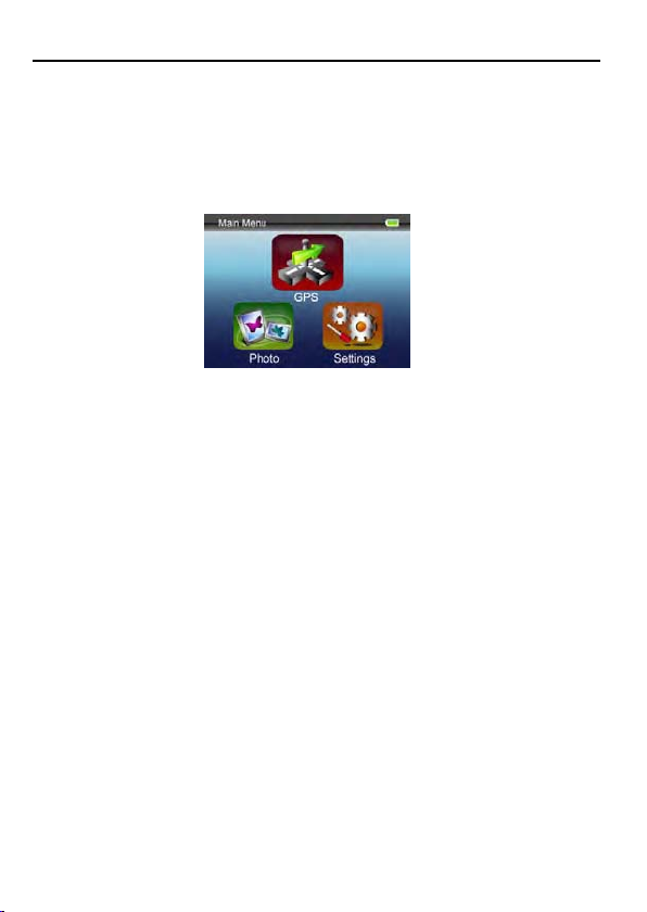
GETTING STARTED
Getting Started
This device combines GPS function and photo viewer. Before you begin to install and use this
product, please read this manual carefully for fully exploiting the functions of this product. If you
experience any problems, go through the user guide before contacting the customer helpline.
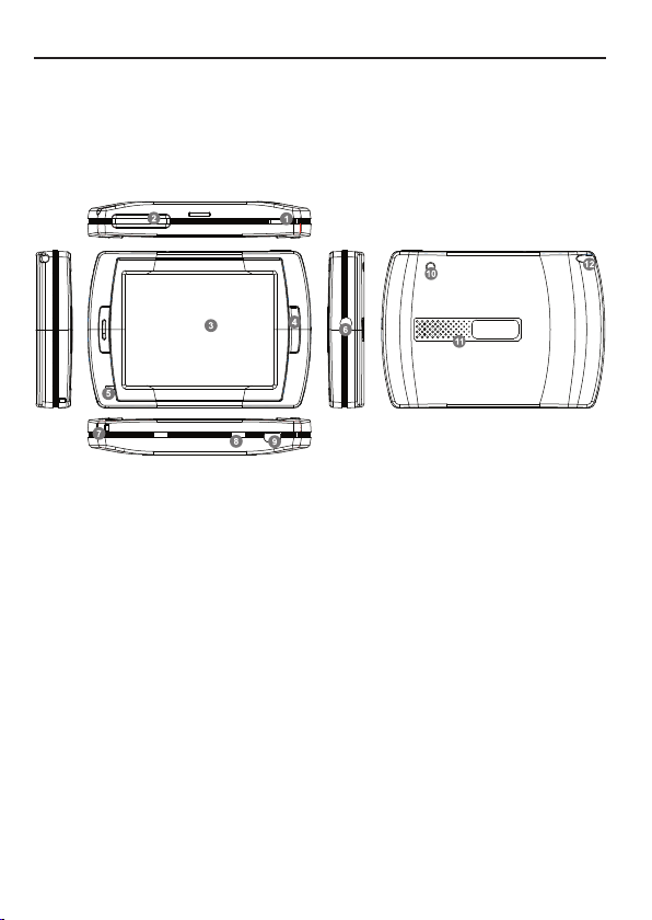
Position of the controls
1. Power Button
2. SD Card Slot
3. Touch Panel
4. Menu Button
5. Indicator Light (When it charges the red light will be on; when fully charged the green light will be on.)
6. Headphone Jack
7. Strap Hole
8. Battery Switch (For leaving long term unused, switch it to off. Or, switch it to off and on for reset.)
9. USB Port
10. External GPS Antenna Port
11. Speaker
12. Stylus Pen/ Slot (Slides the stylus pen out of the slot for operation.)
5
Page 6
GETTING STARTED
Battery Consuming
The device is integrated with a 1000mAH/ 3.7V Li-polymer battery. It can be used for about 3 hours
for GPS function.
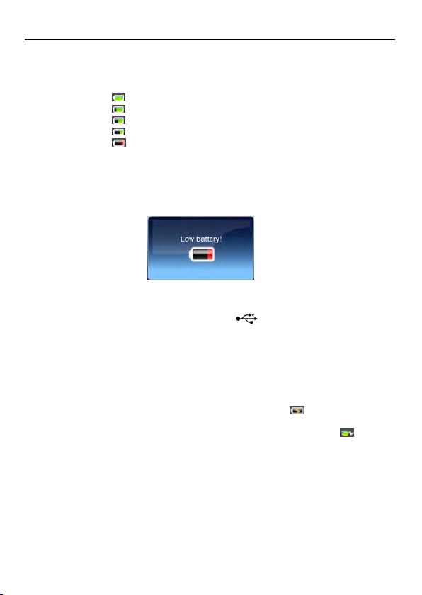
The battery icon shows at the right upper corner of the display.
You can also go to Settings/ Power Status item to know the specific percentage of remaining
battery capacity.
Display shows “Low Battery!” message automatically in weak battery status. When battery capacity
leaves 15%, the message will be shown for 2 seconds. However, when electric charge leaves 5%,
the message will keep showing on the screen until the user shuts down or the electricity is run out.
: means the battery capacity is full.
: means the battery capacity is 80% left.
: means the battery capacity is 60% left.
: means the battery capacity is 40% left.
: means the battery capacity is 20% left.
Charging the Battery
Before using your PND for the first time, we recommend you to charge the unit for 5 hours via the
USB cable or 2 hours via the car charger in order to charge the battery.
Plug the USB cable or the car charger into the USB socket .
When you use the PND in your car, we recommend that you always use the car charger in order to
maintain the battery level.
*Disclaimer: some laptops could have insufficient power through the USB port and could lead to
damage your laptop USB port. Binatone Carrera will not be held in any way responsible for the
damages caused to any laptop by charging the device through the laptop USB port
*Charging via USB cable will be faster when the unit is powered off.
When the device is connected to car charger the battery icon will become
on the front of the unit will blink in red.
When the battery is fully charged, and the car charger is still connected, the icon will be . And
the LED will be in green color.
. The LED indicator
Car Adapter
When using your PND in the car we recommend that you always use the in-car charger to power
the unit, especially on long journeys.
Plug the in-car charger into the USB socket of the unit. Plug the other end of the adapter into the
car’s cigarette-lighter / 12V DC socket.
6
Page 7
r
GETTING STARTED
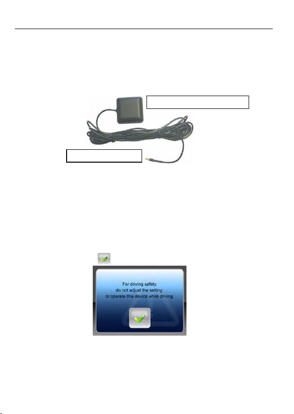
External Antenna (sold separately)
If the GPS receiver fails to acquire a valid signal when mounted in your car it may be due to a heat
reflecting coating or heating elements in your windscreen. In these cases use an external antenna.
The antenna has a magnet and can be positioned in various locations in or outside your car to
obtain the best signal reception. Push the antenna into the socket on the rear of the unit until it
clicks into place. Then position the antenna so that you receive a valid signal.
Position the antenna on the roof of your ca
Plugs into the back of the PND
*External Antenna Optional
Additional maps and upgrade:
Please visit on www.binatonecarrera.com website for more information.
Switching On/ Off
NOTE: For the very first time using the unit, you have to switch the Hardware Reset Switch to ON
with the stylus.
Press the Power Button for 3 seconds to turn the unit ON; you will see the figure below to warn you
about driving safety. Tap on the
When the Hardware Reset Switch is at ON position, press the Power Button for 3 seconds to turn
the unit on. The following screens will be displayed, and the unit is ready to be used. Tap on an
icon to enter the function.
button to continue.
7
Page 8

GETTING STARTED
Press the Power Button for 3 seconds to turn the unit into Sleep Mode.
Press Power button for 5 seconds to wake up the device, then display shows the status before
entering Sleep Mode.
8
Page 9
GETTING STARTED
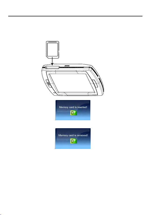
SD Card Installation
If you have a SD or MMC memory Card, you may install it to extend the storage capacity of the unit,
or to view the photo saved on the card. When installing it can only be fitted one way – the wording
face towards you and the cut-off corner at the bottom as shown. Insert the card in and push it in so
that it clicks in place.
Insert a SD card into the slot, and you will see the message as below.
If you need to remove the card, push the card in and it will eject from the slot. And you will see the
figure below.
Note: the card slot can also be a card reader, refer to the following section to operate.
9
Page 10
GETTING STARTED
Connect to PC
You can connect the unit to PC for transferring data. Insert a SD/ MMC card to the card slot, you
can use the unit as a card reader.
1. Power on the unit.
2. Plug B-type end of the supplied USB cable to the mini USB port of the unit, and plug the other
end to your computer.
3. The system will try to recognize and connect the device; the display will show as the figure
below.
4. And now you can find 2 new USB devices in My Computer. The second device represents the
memory card slot, only available when a SD/ MMC card is inserted. Copy or move the data
needed between your PC and the unit.
10
Page 11
GETTING STARTED
Photo
This device supports jpg, bmp, png, gif formats (up to 12MegaPixel file). Enter "Photo" function to
see thumbnails for all the photo files.
Note: press Menu button to go back main menu.
If you see an icon on the list, it means that photo is unsupported. Tap on a photo you
want to view, and then you can tap on the left or right triangle to view the previous or next photo.
To view pictures (bmp and jpeg formats only) from a SD card:
1) Copy all the pictures you want to view into the SD card.
2) Insert the SD card into the slot. In Photo thumbnails list, tap on "SD Card" folder to enter.
3) You will see thumbnails of photos on the card, view and operate as you do to photos on unit.
Tap on the photo, you will see Exit
corner of right side. Tap on
open the Tool Bar. After 5 seconds idling, the buttons and the tool bar will disappear, tap the photo
again to see and operate the buttons.
and More buttons on the upper and lower
button to go to previous level menu. Tap on button to
11
Page 12
Slideshow
Tap on the
After tapping on the
y Tap on
y Tap on
y Tap on
y Tap on
Rotate
Tap on
y Tap on the
y Tap on
button to set the slideshow interval among 2, 3, and 5 seconds.
button to mute the touch tones.
button to adjust the touch tones.
button to rotate the current photo.
button to restore the photo and zoom in.
GETTING STARTED
button to view the photos show one by one automatically.
button, slideshow tool bar will prompt instead.
button again to stop slideshow.
button again to rotate the photo by 90 degree clockwise again.
12
Page 13
GETTING STARTED
Zoom in
Tap on
y Tap on the
y Tap on the
y Tap on
Note: when the zoom in or zoom out limitation is met, the zoom in/ zoom out button will become in
gray color and not selectable.
button to zoom in the photo.
button to zoom in.
button to zoom out. When the photo is zoomed in, you can tap and drag it to
view the part you need.
button to restore the photo.
13
Page 14
GETTING STARTED
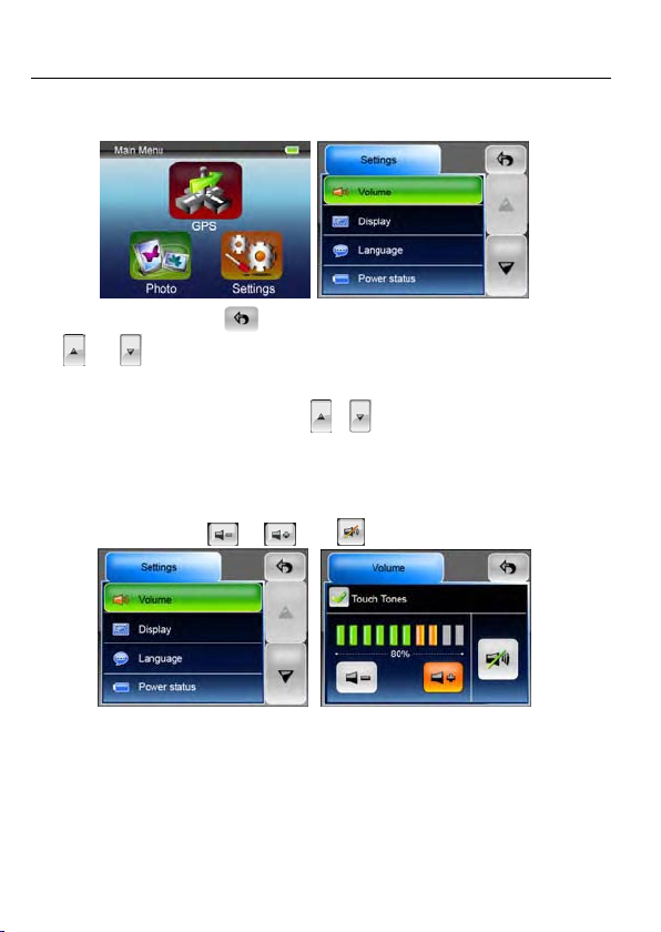
Settings
NOTE: You do not need to enter the Settings menu before you start to navigate. Tap on the
Settings icon on the Main Menu, the following screen is displayed.
To exit this page, tap on the Exit
and button means there are more options available. Tap on one of them to scroll
The
the list to find out the other options.
Note: when there is no option above/ below, the
not selectable.
button at the upper-right corner of the screen.
/ button will become in gray color and
Volume
Press 'Volume' you can modify the volume level of the voice prompts. You can increase or
decrease the level by clicking
You can also check or un-check the blank of Touch Tones, to enable or disable the beep sound
when you touch the screen.
Note: when the minimum or maximum volume level is met, the volume down/ volume up button will
become in gray color and not selectable.
14
or . Click to mute.
Page 15
GETTING STARTED
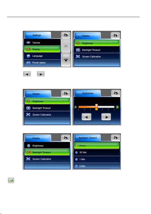
Display
Tap on the Display option to enter display submenu. There are 3 items to adjust: Brightness,
Backlight Timeout, and Screen Calibration.
Brightness: With this item, you can change the brightness of the screen. Adjust it darker or brighter
by tapping
Note: when the minimum or maximum brightness level is met, the level down/ level up button will
become in gray color and not selectable.
Backlight Timeout: Select an option to set idling time to shut down the display to save battery
consuming. If you want it to display continuously, select “Never”.
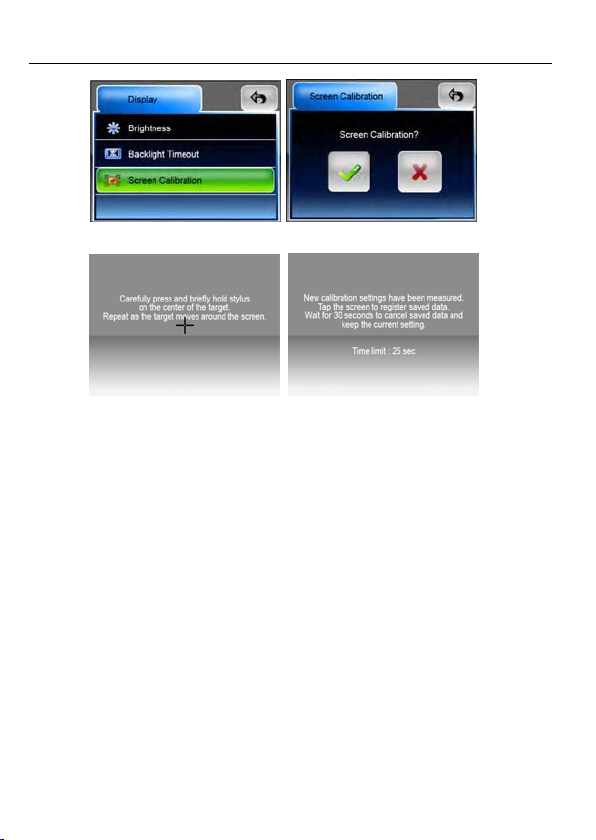
Screen Calibration: This function calibrates the unit to respond to your screen taps. You will need
to use this function only if the unit begins to respond inconsistently to your screen taps. Tap on
button to start.
or button.
15
Page 16
GETTING STARTED
Follow the on screen directions to tap on the center of the cross to calibrate. When the steps are
done, you will see the second figure, tap on screen to save and apply the new calibration.
16
Page 17
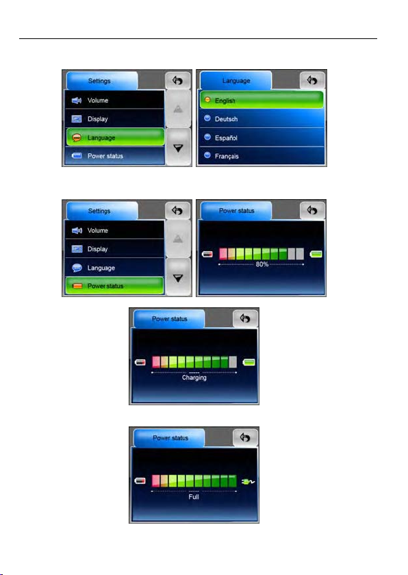
Language
Tap to select a language from the list to suit your need.
GETTING STARTED
Power Status
Enter this filed to know the battery status.
While charging, the status will be in motion, and noted “Charging”.
If the battery is fully charged and the USB cable is still connected, the display will show as the
figure below.
17
Page 18
GETTING STARTED
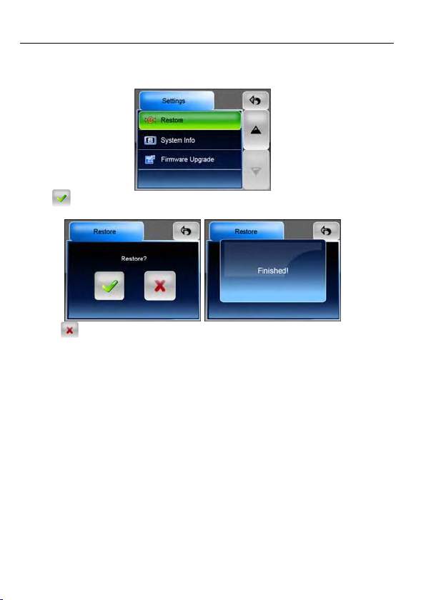
Restore
This field is for you to restore the settings to default values. When necessary, tap on “Restore” item
to enter.
Tap on
message will prompt.
Or tap on
button to restore all the setting values. After the procedure is done, the “Finished!”
to cancel and exit.
18
Page 19
GETTING STARTED
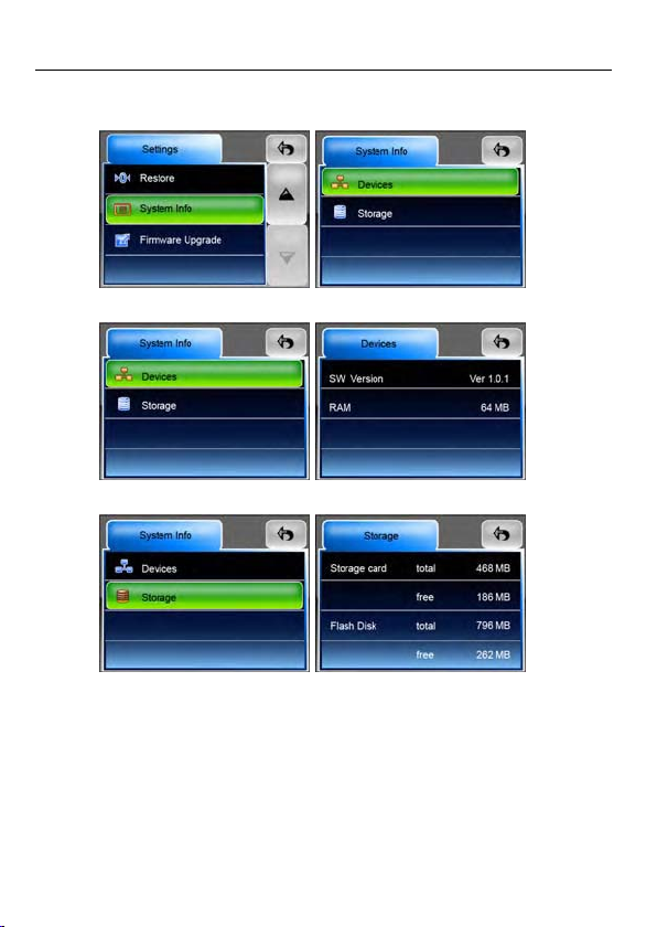
System Info
Tap on System Info to know the information of the unit and the inserted memory card. There are 2
items to read: Device and Storage.
Devices: The Devices page shows information about your software versions and capacity of the
embedded memory.
Storage: The Storage page tells the total capacity and free capacity of your storage card (if
installed) and the flash disk. If no storage card is installed, the information will show as N/A.
19
Page 20
GETTING STARTED
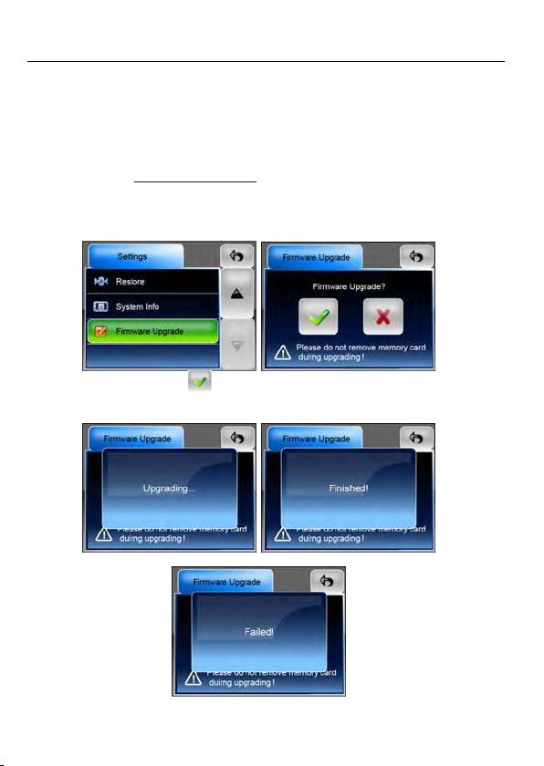
Firmware Upgrade (advanced feature)
You can upgrade the firmware of the unit for better performance or/ and more functions. Follow the
steps below to do so.
Note 1: only advanced users are recommended to operate this feature.
Note 2: before upgrading, please make sure that the battery capacity if filled, or power the unit with
the car charger to ensure the upgrading will not be corrupted.
Note 3: do not remove the memory card during upgrading!
Note 4: please visit on www.binatonecarrera.com
1. Download the firmware file from our website. Uncompress the file and copy it to a SD/ MMC
memory card. Insert the card into the card slot of the unit.
2. Tap to enter this field; you will see the figure as the second below.
3. To start to upgrade, tap on the
“Upgrading…” message will prompt. In some seconds, “Finished!” message will prompt after the
upgrading is done.
website for more information.
button. The unit will restart automatically and the
4. If the upgrading is failed, you will see the below figure, shows “Failed!” message.
20
Page 21
INTRODUCTION
GPS FUNCTION
You have chosen a cutting-edge navigation system. Congratulations! Please enjoy using it. Binatone
Carrera is embedded as Global Positioning System in this unit. Th
straight to your destination, whether you are traveling by ca
your route with an easy-to-use and intuitive interface, just by
also use this application to plan your trip to suit y
to save interesting destinations before you set off on your
main features of the system.
our personal preferences and interests and
is navigation system leads you
r or on foot. You can navigate and plan
using your finger or the stylus. You can
journey. This manual leads you through the
Introduction of Binatone Carrera
Binatone Carrera is a navigation system optimized for in-car us
for both single and multi-point routes using adaptable route
of planning routes throughout the whole installed map set. Unlike some
Carrera does not require that you change maps or switch to a poorly detailed gen
between map segments or countries. You always have complete freedom to
Just select your destination and go.
Note: the position information obtained from the GPS receiver will not be transmitted anywhere, so
others will not be able to track you by the help of this program.
e. It provides door-to-door navigation
parameters. Binatone Carrera is capable
other products, Binatone
eral map to navigate
go wherever you wish.
Safety Instructions
y The driver’s attention should always be on the road. If you are the driver of the vehicle, we do
not recommend you to operate this unit while driving. Plan your route before departure and pull
over if you need to change route parameters.
y from using the screen functions
Binatone Carrera has a built-in Safety Mode that will prevent you
if your car is in motion. Unless a passenger will be the only one to operate Binatone Carrera, we
strongly encourage you to turn on the Safety Mode.
y It is also important that you look at the display only if it is absolutely safe to do so.
y You should always observe traffic signs and road geometry before obeying instruction from
Binatone Carrera.
21
Page 22
INTRODUCTION
Getting Started
Please make sure that the battery in your device is fully charged, or use the car charger to power
on the PND device.
Connect the external antenna for better reception. (the external antenna is optional)
Install or place your PND device in a location with an unobstructed view to the sky. (In a car this
will usually be on the dashboard.)
Switch on the unit and choose GPS.
It may take up to some minutes to establish the first connection. Subsequent connections will be
faster (30 seconds to 1 minute), but if you have not used the unit for days or are far away from
the lastlocation whereyou used it, it maytake up to 10 minutes again to find a strongsignal.
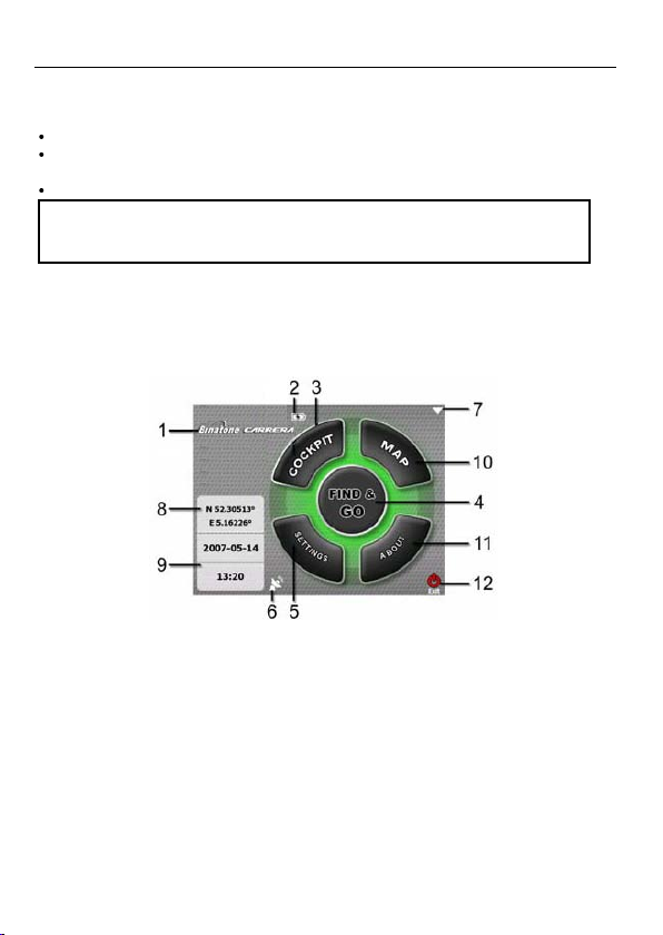
Main Menu
Binatone Carrera starts by displaying the Main menu. This is
you need to return here very rarely while using the program
other to reduce the number of actions needed to in
Most parts of the program are directly accessible from here by using the buttons described below.
1.
Binatone Carrera
2. Battery Status indicator
3. Button to open Cockpit screen
4. Button to open Find menu
5. Button to open Settings
6. Button that displays GPS Status and opens the GPS Data screen
7. Button to shut down and exit
8. Current position
9. Current date and time
10. Button to open Map screen
11. Button to open About screen
22
Binatone Carrera
the root of the screen hierarchy, but
. Screens are also accessible from each
itiate a function or change a setting.
Page 23
ACTIVE MAP ELEMENTS
About Screen
Tap About on the Main menu screen to open this screen. The About screen is not used in normal
navigation. It is there to inform you about the map licenses you have, the creators of Binatone Carrera
and the legal aspects of using the program.
Map Screen
Cockpit Screen
23
Page 24

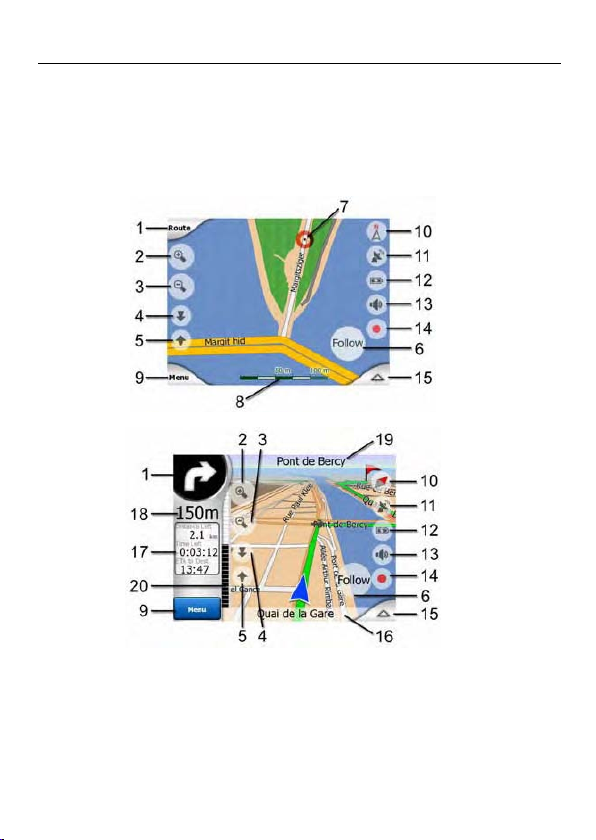
No. Display Control
1 (Cockpit only) Turn preview* Opens Route menu*
2
3
4
5
6
Indicates that Lock to GPS
position and heading is inactive
7 Selected map point (Cursor) Opens Popup Info and Cursor menu
8 (Map only) Map scale Zooms in/out by dragging
9 Menu Button Go to Main Menu (Find, Quick, Route, Main)
10 Map orientation and Overview Switches North-up, Track-up and Overview
11 GPS position quality Opens GPS Data screen
12 Battery status Opens settings
13 Sound on or muted Enables/disables muting
14 Track Log recording or playback Opens Track Logs screen
15 n/a Opens Cursor menu
16 (Cockpit only) Current street Opens Route Information screen
17 (Cockpit only) Travel and Route data** Opens Route Information screen
18 (Cockpit only) Distance to next turn*** n/a
19 (Cockpit only) Next street*** n/a
20 (Cockpit only) Approaching next
turn****
Zooms in (optional)
Zooms out (optional)
Tilts down (optional)
Tilts up (optional)
Re-enables Lock-to-Position / Smart Zoom
n/a
* On Map screen only when a route is active
** Contents differ when a route is active
*** Appears only when a route is active
**** Appears only when a route is active and the next turn is near
ICONS
24
Page 25

MAIN ELEMENTS
Explanation of map display contents and features
No. 1 - Turn preview
On the Cockpit screen this field shows a graphic illustration of the next manoeuvre. For example
when you approach a turn, an arrow will show whether it is a slight, normal or sharp turn. When
showing a roundabout, the number of the exit is also given in the picture.
This field also serves as a button. Tap it to get to the Route menu. The Map screen will show a
button called Route here if there is an active route. This also leads to the Route menu.
No. 2 & 3 - Zoom in and out
These semi-transparent buttons are only displayed if "Zoom & Tilt" is enabled in the Quick menu.
Zoom will change the scale of the map. Zoom out shows a larger part of the map, while Zoom in
shows a smaller part of the map in more detail.
The automatic Smart Zoom function will do the necessary zooming for you when navigating (zooms
out if the next turn is at a distance to let you see far ahead and zooms in when approaching a turn
to give you a better view of the upcoming manoeuvre). If you manually change the zoom level,
Smart Zoom will no longer scale the map by itself (automatic tilting and rotating remains active).
Tap the Follow button to return the zoom control to Smart Zoom. You can also set Binatone Carrera
to do this automatically after a few seconds in case of the Cockpit screen.
No. 4 & 5 - Tilt up and down
These semi-transparent buttons are only displayed if "Zoom & Tilt" is enabled in the Quick menu.
This function modifies the vertical viewing angle of the map in 3D mode. You can change the angle
in a wide range starting from a top down view (2D view is seamlessly integrated) all the way to a
flat view that lets you see far ahead.
The automatic Smart Zoom function will do the necessary tilting for you when navigating (gives a
flat view if the next turn is at a distance to let you see far ahead and raises the angle when
approaching a turn to give you a better view of the upcoming manoeuvre). If you manually change
the view angle, Smart Zoom will no longer tilt the map by itself (automatic zooming and rotating
remains active).
Tap the Follow button to return the tilt control to Smart Zoom. You can also set Binatone Carrera to
do this automatically after a few seconds.
No. 6 - Follow mode - lock to GPS position and heading
This semi-transparent icon is displayed if GPS position is available, and the map has been moved
or rotated. It also appears when you scale or tilt the map while Smart Zoom is enabled.
25
Page 26

MAIN ELEMENTS
Normally Binatone Carrera positions the map to keep the GPS position visible somewhere on the
map (when North-up orientation is selected), or always at
Track-up orientation is selected).
If you manually move the map, it will freeze the map in the new position. To return to the GPS
position, use this Follow button.
Rotating the map in any direction will only freeze the orientation of the map, but it keeps on moving
to keep the GPS position visible. Use Follow to return to North-up or Track-up orientation (the one
previously selected).
When Smart Zoom is enabled, scaling or tilting the map also stops the automatic zooming or
automatic tilting respectively. To reactivate Smart Zoom, tap this button.
Tip: In Advanced settings you can set a delay time after which Binatone Carrera pushes the Follow
button for you on the Cockpit screen automatically. This can be turned on for re-enabling both
Lock-to-Position and Smart Zoom.
No. 7 - Cursor
As described earlier, if you tap the map somewhere or select one specific item in Find, it will
become the selected point on the map, marked with a small red dot and radiating red circles to
make it conspicuous. You can use this point as starting point, via point or destination for your route,
you can search for a POI near it, mark it with a pin, or save it as a POI.
Note: When GPS position is available, the Follow button will appear indicating that you have
disabled Lock-to-Position. Tapping the Follow button will re-enable the position lock and move the
cursor back to the current GPS position. The same happens when Binatone Carrera restores Lock-to
-plsition automatically on the Cockpit screen, if
No. 8 - Map scale
The scale indicator is only available on the Map screen. In 2D map view it represents the scale of
the map. In 3D view it is the scale of the nearest part of the map only.
You can use it in both 2D and 3D modes to scale the map. Drag and pull it right to zoom in, or left
to zoom out.
No. 9 - Menu
This button opens the Menu with the Find engine, the Quick menu, the Route menu and the exit
button that takes you to the Main menu screen.
No. 10 - Map orientation and Overview
You can view the map screens in three different presentation modes. This switch will cycle through
them in the following order.
: The usual map orientation for navigation is Track-up. It means Binatone Carrera rotates the
map during navigation to always face the direction of your
towards North.
points
the bottom centre of the map (when
it is set in Advanced settings.
travel. In this mode an arrow (compass)
26
Page 27

MAIN ELEMENTS
: Tap this icon to switch to North-up mode. Now the map is fixed to keep facing North. The
icon changes to show the new rotation mode.
Tap the icon again to enter Overview mode. This mode looks similar to the North-up mode with one
difference: the zoom level in this mode has a fixed default to give you a better look of where you
are on the map. You can change the zoom level at any time, this will not cause the Follow button to
appear, but when entering Overview mode later, the default zoom level will be restored.
The arrow representing your position will be fixed in the middle of the screen. When you move the
map in Overview mode, the Follow button will appear, and when pushed, it will move the map to
have your current position in the middle of the map again.
You cannot rotate the map in Overview mode. This mode is strictly north-up.
You can set up Binatone Carrera so that it will switch to Overview mode during navigation when the
next turn is far away. You can specify this distance and the fix
settings.
An aeroplane icon
(automatic rotation) mode.
No. 11 - GPS position quality
Similarly to the icon found on the GPS Data screen (Page 34), the map screens also inform you
about the GPS signal:
: The black satellite dish with the red exclamation mark shows there is no connection with the
GPS receiver. GPS navigation is not possible. Devices with a built-in GPS receiver are
permanently connected, so this icon may not appear under normal circumstances.
: Red shows there is a connection, but the signal is too weak to give a position. GPS
navigation is not possible.
: Black shows there is a GPS position, and navigation is possible. When only one arc is
shown, the position is 2D (no altitude available), and position error may be significant, yet
Binatone Carrera is
: A black dish and two arcs represent a 3D GPS position. Binatone Carrera is ready to navigate.
: When small car symbols are displayed under the dish, TMC information is available.
No. 12 - Battery status
The status of the battery is also shown by Binatone Carrera. You can estimate the available power
reserve from the length of the bar inside. Some examples:
: The thunderbolt in the battery shows the battery is being charged.
: Battery is not charging, but it is at full capacity.
: Battery in not full, but there is sufficient reserve capacity.
indicates Overview mode. Tap the icon again to return to Track-up
ready to navigate.
ed zoom level of Overview in Advanced
27
Page 28

MAIN ELEMENTS
: When the inside of the battery turns red, the battery needs recharging.
Note: Binatone Carrera cannot display the battery status of the GPS device unless it is built into the
PDA and uses the same battery.
No. 13 - Sound muting
By tapping this button you can quickly mute all sounds of the unit. This will not modify the volume
level and the enabled or disabled status of the voice guidance or the key sounds, just mutes the
sound output. When muting is enabled, the speaker icon is crossed out
Tap again to re-enable sounds
Note: Sound can be muted in Sound settings, too. There you have a Master switch that works
together with the switch described above. There is also a Master slider on that screen. That you
can use to fully turn down the volume of the device. Setting the volume low is different from muting,
therefore it will not show up on the mute indicator.
No. 14 - Track Log recording/playback indicator
When a track log is being recorded, a red icon is displayed on the map screens. This icon also
functions as a button leading to the Track Log screen where you can stop the recording or make
the track log visible on the map
During track log playback a green icon will blink. Tapping this icon (in fact, tapping the screen
anywhere) stops the simulation
No. 15 - Cursor menu
The Cursor is the selected point on the map (marked by a red dot and radiating red circles around
it), or the current GPS position when it is available and Lock-to-Position is enabled. When you tap
the screen to place the Cursor, the Cursor menu pops up automatically to give you the list of
possible functions you can use the Cursor for. At the same time Popup Info (street name, house
number and the list of POIs nearby) appears near the selected map point if Popup Info is enabled
in the Quick menu.
If you do not use the Cursor menu in a few seconds, it will automatically vanish back to the bottom
of the screen, and Popup Info disappears, too. You can have them reappear by reopening the
Cursor menu using the arrow in the bottom right corner. When you open the menu manually, it will
stay on until you close it or switch to another screen.
Tip: If you want to see the map around the Cursor, close the Cursor menu and reopen it. When this
menu is opened manually, the map is always moved to have the cursor in the centre.
The content of the Cursor menu depends on the screen (Map or Cockpit) and it is slightly different
if there is an active route already planned. You have the following options:
• Start: use the Cursor as the departure point for your route. This menu point is available only in
Map mode and when there is no active route. In Cockpit mode the departure point of the route is
always the GPS position or if it is not available, the last known GPS position.
• Route To: use the Cursor as the destination of your route. This button is to start a new route. The
previous route (if it exists) will be deleted and replaced. If a multi-point route is active, Binatone Carrera
28
.
.
.
.
Page 29

MAIN ELEMENTS
will ask you whether you really want to delete it together with all its via points.
• Add Via: by inserting the selected map point as a via, you instruct Binatone Carrera to cross this
location before the destination of the route. This is the wa
order (when you wish to insert a stopover ‘go to A but first get some fuel at B’ or want to influence
the direction of the route). This menu point wo
• Remove Via: removes the ‘via point’ near or at the Cursor. The route will be recalculated
immediately excluding the deleted point. This menu point replaces Add Via and is available only if
the Cursor is near or at a via point.
• Continue: add a new destination to be reached after the previous destination. The new
destination replaces the old one, which is now demoted to a via point. This is the way to build
your multi-point route in straight order (when you wish to visit several destinations ‘go to A then to
B’). This menu point is available only if a route is already active.
• Pin: push a coloured pin in the map at the selected point for later use. This pin is visible at all
zoom levels and also appears in the History list together with its exact position. The colour of the
pin is automatically selected by .
• Unpin: remove the pin near or at the Cursor. This menu point replaces Pin and is available only if
the selected point is near or at a pin.
• POI: opens the list of POIs near the selected point. These are the POIs shown in the Popup Info
window. This menu point is only available on the Map screen. If you want to add a new POI at the
cursor, you can do so by tapping Add POI in the bottom left corner. You can also add a new road
safety camera if you tap Add Cam, and set the parameters (type, direction, and speed). If a
camera already exists near the cursor, this button is inactive, and you can change the parameters
of the camera by tapping it in the list.
No. 16 - Current street
This field of the Cockpit screen shows the name or number (as available) of the current street or
road you are driving on.
Tip: Some roads have an alternative name (or number). This is normally shown together with the
primary name in this field. You can hide these alternative names in Map settings.
No. 17 - Travel and Route data
The contents of these three fields are different when cruising (without an active route) or navigating
(following an active route).
While cruising, the fields show the present speed, the current speed limit and the time of day.
While navigating a route, these fields show the estimated time needed to reach the destination
(ETE), the distance to destination, and the estimated arrival time at the destination (ETA) by
default.
You can choose what to display in these three fields during navigation, by going to Advanced
settings / Display Options (Page 86). See the following list for your options. The only restriction is
that you cannot select a value that already appears in another field. The possible field contents are:
• Distance to destination (default value for the left field)
• Time to destination (estimated time en route, default value for the middle field)
• Distance to next via point
• Time to next via point
• Time to next manoeuvre (next route event)
Binatone Carrera
y to build a multi-point route in reverse
rks only if a route is already active.
29
Page 30

MAIN ELEMENTS
• Speed
• Speed limit
• Arrival at next via point
• Arrival at destination (default value for the right field)
No. 18 - Distance to next turn
This field shows the distance to go before reaching the next route event (turn, roundabout, exit, etc.)
This field is only displayed when navigating a route.
No. 19 - Next street / Next settlement
This field shows the road or street that comes next in the route itinerary.
If you are not yet in the settlement where this next street is, Binatone Carrera will display the name of
the settlement instead of the name of the road or str
of settlements to help you tell them apart from street names.
This field is only displayed when navigating a route.
No. 20 - Approaching next turn
This bar is only visible when approaching the next route event. It appears on the screen to visualise
the distance when you get closer than 300 meters (1000 feet) to the next turn, and it remains
visible till you reach the turn.
This field is displayed only when navigating a route.
eet. A bullet symbol will appear next to the name
30
Page 31

Settings
Binatone Carrera provides several settings in order to let
The Settings screen can be accessed directly from t
by using the battery icon, while some of its subprogram.
he Main menu screen and from the map screens
screens are accessible from other parts of the
MAIN ELEMENTS
you customise the functions of the program.
General settings
These are the basic settings of
Safety Mode
Safety mode will disable the touch screen above 10 km/h (6 mph) to keep your attention on the
road. You cannot set a new destination or change the settings. When you disable Safety Mode,
Binatone Carrera will warn you.
Set Favourite Destinations
You can select two of your most frequent destinations to be your favourites. You can start
navigating to either of them by only two taps on the screen. The original names of these points are
Home and Work.
Binatone Carrera
.
31
Page 32

MAIN ELEMENTS
You can rename them and specify their locations. To determine the location you can use the same
Find menu options as for a route destination, and depending on that choice and the information
available, the location will be shown here as a street address, a latitude/longitude position, or both.
Note: If you tap either of your favourite destinations in the Find menu before defining it, bB inatone
Carrera will offer to take you to this screen to set it up.
Automatic Night Colours
Using the automatic night mode, Binatone Carrera will change between the daylight and night colour
schemes a few minutes before sunrise and a few minutes
information provided by your GPS. Once you set a permanent colour scheme in the Quick menu,
this automatic mode turns off. If you need Binatone Carrera to switch between colours for you again,
you need to re-enable this feature.
Alerts
Tap this button to enable and fine-tune user alerts. A new window opens with the options.
Warn When Speeding
Maps may contain information about the speed limits of the road segments. Binatone Carrera is able
to warn you if you exceed the current limit. This informat
your local dealer) or may not be fully correct for all r
whether you want to receive the warnings or not.
Speeding tolerance
Binatone Carrera will warn you when you exceed the speed limit by the amount specified here. Select
whether you want to specify the tolerance as a Fixed va
The slider will change depending on which mode you have chosen.
Both positive and negative values can be given in either offset or percentage mode.
32
ion may not be available for your region (ask
oads in the map. This setting lets you decide
lue (offset to the speed limit) or as a Percentage.
after sunset based on the time and location
Page 33

MAIN ELEMENTS
Alternative speed limit
If the speed limit of the current road segment equals or is above this limit, the speed warning will
use the alternative tolerance instead of the previous one.
Move the slider to its rightmost position to turn off the alternative speed warning. Then the settings
of the upper slider will determine the warning for all roads.
Alternative speeding tolerance
If the speed limit of the current road reaches the value set at Alternative speed limit, this setting will
replace the basic one set at the top of this screen. The slider and the selector work exactly as the
basic ones described here: Page 74.
Example: to let you better understand how this feature works, here is an example. If you use the
settings +10 km/h – 100 km/h – +5%, Binatone Carrera will warn you when driving at the following
speeds:
Speed limit Warning at
40 km/h 50 km/h (=40 km/h + 10 km/h)
60 km/h 70 km/h (=60 km/h + 10 km/h)
90 km/h 100 km/h (=90 km/h + 10 km/h)
100 km/h 105 km/h (=100 km/h + 5%)
Map settings
You can set a few parameters determining the appearance of the maps in Binatone Carrera.
120 km/h 126 km/h (=120 km/h + 5%)
160 km/h 168 km/h (=160 km/h + 5%)
Daylight / Night colour profile
Binatone Carrera comes with different colour schemes for
always one selected daytime scheme and one selected night-time scheme. Binatone Carrera uses
these when switching from day to night and back.
Tap the appropriate button and select a new scheme from the list.
Alternative Road Names
Some highways have an international name or number for foreign travellers. You can decide
whether to show only the local name or both.
Show Street Labels
You can set whether or not to see the names of the streets and the POI icons on the map when
driving. Based on the current zoom and tilt levels, street names are displayed either aligned with
both daylight and night use. There is
33
Page 34

MAIN ELEMENTS
the street or on signposts stuck into the streets. If you switch these signs on, it will be easier to
recognise your location on the map, if you turn them off, it will be easier to see the road geometry.
Note: You can only disable street names and POI icons if Binatone Carrera follows your position.
As soon as you move the map and Lock-to-Position is disabl
visible again. Tap Follow to re-enable Lock-to-Position and have the labels and icons disappear again.
Textured Polygons
Enable textured polygons, and have rivers, lakes, forests and other large objects displayed in a
more realistic and attractive way on the map.
Disabling it will lead to uniform areas but better performance for old PDA devices with a slow
processor.
Sound settings
Settings on this page determine the way sounds.
Binatone Carrera
ed, street names and icons become
Note: The Mute function accessible from the map screens overrides the settings on this screen.
When bB inatone Carrera is muted, all sounds disappear. These settings will not be changed; only the
output will be muted temporarily.
Master sound volume/switch
The loudness of Binatone Carrera is independent of your PDA settings. When you run Binatone
Carrera the position of the fader determines the device volume level. When
device settings return. The left part of this control works as a
Carrera sounds. This works in tandem with the Mute button on the map screens. Switching one of them
will change the status of the other.
Voice guidance volume/switch
The switch on the left can turn on or mute Binatone Carrera's audible guidance. When turned on, the
slider on the right will adjust the loudness of voice prompts.
suppressed, in its rightmost position the master volume applies.
Key sound volume/switch
The switch on the left can turn the key sounds on or off. Key sounds are audible confirmations of
either pressing hardware buttons or tapping the touch screen. When key sounds are turned on, the
slider on the right will adjust their loudness. In its leftmost position the key sounds are suppressed,
in its rightmost position they are played at the master volume level.
34
you exit the program, the
mute button. Tap to mute all Binatone
In its leftmost position the voice guidance is
Page 35

MAIN ELEMENTS
Note: The sound effects of binatone carrera are context sensitive. They will be different if, for example
you open or close a window, or you enable or disable a se
entered enough letters of a street name to have a short list of matching streets on the screen.
Dynamic Volume
When driving at high speed, the noise in the car may be too loud to clearly understand the voice
guidance messages and to perceive the key sounds. Using Dynamic Volume you can instruct
Binatone Carrera to increase the volume when your speed exceeds a
highest volume (determined by the Master volume slider in
Tap the Dynamic Volume button to turn on the feature. This will also open the screen where you
can set the minimum and maximum speeds.
tting. They will even let you know if you have
certain minimum, and reach its
Sound settings) at the given maximum speed.
Attention Tone
If this is set to Disabled, the voice guidance will sound without a preceding attention tone. Setting it
to Single Tone will initiate a single attention tone before the instructions, while Double Tone will use
a double tone.
Route parameter settings
This is a very important page. Settings here determine how routes will be calculated. This screen is
directly accessible from the Route Information screen.
Method
Use the handle to set the speed of the route calculation. In the leftmost position the route may not
be optimal but the calculation will be very fast. Sliding it to the right will result in more accurate
routing in an increased amount of time.
Note: Since Binatone Carrera calculates routes very quickly, the position of this slide is only used
for long route Short routes are always calculated to give ys
slider.
ou the optimal result independent of the
35
Page 36

MAIN ELEMENTS
Route
Here you can choose from three different route types.
• Short: Choosing Short will result in a route that has the smallest total distance of all possible
routes between the given points. This is usually preferred by pedestrians, cyclists or slow
vehicles.
• Fast: Choosing Fast will result in the quickest possible route, given that you can travel at or near
the speed limits on all included roads. This is usually preferred for fast and normal cars.
• Economical: This setting is a wise combination of the previous two. Although basically going for
the fastest solution, if there is another route taking a bit more time but a lot less distance
compared to the fastest one, Binatone Carrera will choose this one instead to save fuel.
Vehicle
You can set the type of the vehicle that you will use to navigate the route. Based upon this setting,
some of the road types will be excluded from the route (e.g. motorways for pedestrians), or some of
the restrictions may not be taken into account (e.g. emergency vehicles have no restrictions).
Furthermore, when Bus or Lorry is chosen, the program assumes that high speeds cannot be
achieved, and this information is taken into account when calculating the route, the estimated time
enroute (ETE), and the estimated time of arrival (ETA).
Available values:
‧ Car
‧ Taxi
‧ Bus
‧ Lorry
‧ Emergency
‧ Pedestrian
‧ Bicycle
Road types to include/exclude
To let the route fit your needs you can also set which road types are to be considered for or to be
excluded from the route if possible.
Note: Excluding a road type is a preference. It does not necessarily mean total prohibition. If your
destination can only be accessed using some of the excluded road types, binatone carrera will use
them but only as much as necessary. In this case a warning icon will be shown on the Route Information
screen, and the road not matching your preference will be displayed in alternate colour on the map.
Unpaved Roads: Unpaved roads are excluded by default, as they can be in a bad condition and
you usually cannot reach the speed limit on them.
Motorways: When driving a slow car or towing another vehicle, you may prefer not to take
motorways.
Ferries: The accessibility of temporary ferries is not necessarily included in the map data.
Furthermore you may need to pay fare, so you may consider disabling them from the preset
enabled status.
36
Page 37

MAIN ELEMENTS
U-turns: Although displayed amongst road types, this is a type of action. Most drivers prefer to
replace them with a few normal left and/or right turns in the next few junctions, so it is disabled by
default.
Turning back on dual carriageways is not considered as a u-turn.
Note: If you are not totally against u-turns, leave them on here, and add a certain penalty
(equivalent extra distance to travel) in Advanced settings Route options.
Note: Via points are handled as stopovers with regards to u-turns. It means disabling u-turns on
this page will avoid u-turns during the entire route if possible, but when reaching a via point, the
following part of the route may be planned starting in the opposite direction.
Permit needed: To use some roads or enter some areas you may need special permit or
permission from the owners. These roads are excluded from your routes by default. Use this switch
if your vehicle is authorised to enter.
Toll Roads: Toll roads are included in your routes by default. If you wish to travel more to avoid
paying a toll, disabling them will make
Note: You have a few more ways to influence routing and route recalculation in Advanced settings
Route options.
Language & Units
Here you can set the languages, measurement units, and date and time formats used by Binatone
Carrera.
Binatone Carrera plan the best toll-free route for you.
Program language
This button displays the current written language of the program. By tapping the button you can
select from a list of available languages. Binatone Carrera will have to be restarted if you change
this setting. Binatone Carrera will ask for confirmation before it restarts.
Voice language
This button shows the current language of the voice guidance. By tapping the button you can select
from a list of available languages and speakers. Tap any of these to hear a sample voice prompt.
Just tap OK when you have selected the new spoken language.
Units
You can set the distance units to be used by the program. Binatone Carrera may not support all of
the listed units in some voice guidance languages. If you select
supported by the chosen voice guidance language, you will s
selector.
a measurement unit that is not
ee a red warning message under the
37
Page 38

Set Date & Time Format
You can set the date and time format displayed by . Various international formats are .
available.
Binatone Carrera
MAIN ELEMENTS
Advanced settings
These screens let you set a large number of different advanced settings and initiate some special
functions. These settings and functions are divided into groups.
Tap on any button to set the corresponding parameters. They all open new windows where you
can make your desired changes.
Display options
These settings determine how Binatone Carrera displays different content elements or how it
presents the screens.
2D in Map mode (and North-up orientation)
The normal use of the Map mode is to browse the map and look for different places on it. It is
usually done in a top down view having north towards the top of the map. By default Binatone Carrera
uses the same look for the map in both Map and Cockpit modes.
38
Page 39

MAIN ELEMENTS
Use this switch to instruct Binatone Carrera to always open the Map mode in 2D with North-up orientation
for map browsing purposes.
Note: You will still have the possibility to rotate and tilt the map, but the map will return to 2D mode
whenever Map mode is started.
3D in Cockpit mode (and track-up orientation)
The normal use of the Cockpit mode is cruising or navigating, when the road lying in front of the
driver is the most important part of the map. It is usually done in a 3D view with the current
direction towards the top of the map. By default Binatone Carrera uses the same look of the map in both
Map and Cockpit modes.
Use this switch to instruct Binatone Carrera to always open the Cockpit mode in 3D with Track-up
orientation (automatic map rotation)
Note: You will still have the possibility to switch the map to 2D view or north-up orientation, but the
map will return to 3D mode with map rotation whenever Cockpit mode is started.
Zoom in after find
When this switch is turned off, Binatone Carrera will centre the map to the location selected in Find but
will not change the zoom level. If you turn this switch on, Binatone Carrera will also zoom in to the selected
point. The zoom level in this case depends on the type of
the case of a city search, the zoom level will show you the whole settlement or at least a significant
part of it around its centre. Selecting a POI, a junction or an exact address will give you a closer
look with only a few streets on the display.
Coordinate display format
Positions are sometimes displayed with their addresses, and sometimes with their coordinates.
This setting lets you choose between displaying coordinates in degrees (dd.dddddd); degrees and
minutes (dd mm.mmm); or degrees, minutes and seconds (dd mm ss.s).
Note: the coordinate display mode is independent from the coordinate input in Find menu. You can
use all three formats freely on the coordinate input screen.
Cockpit screen layout
There are three route data fields at the bottom of the portrait Cockpit screen, or on the left of the
landscape Cockpit screen.
Their content is fixed in Cruise mode (when there is no active route), but for Navigation mode you
can change their content on this screen.
Backlight settings
Here you can set how the display backlight behaves when using Binatone Carrera.
These settings are independent of the settings of the other applications of Pocket PC.
for driving purposes.
object you have searched for. For example in
39
Page 40

MAIN ELEMENTS
Power management : At the top of the screen you can set how the backlight will behave when the
screen has not been touched for a while.
• Backlight always on: You can choose to have the lights always on.
• Smart powersave: You can also initiate this special feature of Binatone Carrera. When running on
battery, Smart Powersave will light up the screen only when
Carrera has something to show you. After a few seconds
seconds the backlight turns off. This helps you achieve a longer battery life.
few
Brightness
You can set the backlight level separately for both daylight and night modes, thus enhancing the
effect of the night colour scheme.
The values are between 0 and 10, where zero means there is no backlight at all, and 10 represents
the maximum backlight value.
Smart Zoom
Smart zoom is a lot more than just a usual automatic zoom.
While navigating a route: when approaching a turn, it will zoom in and raise the view angle to let
you easily recognise your manoeuvre at the next junction. If the next turn is at a distance, it will
zoom out and lower the view angle to be flat in order to let you see the road in front of you, or it can
even switch to an Overview mode to let you follow your position on the map.
While cruising: if there is no active route and you are just driving, Smart Zoom will zoom in if you
drive slowly and zoom out to the limit set here when you drive at high speed.
These automatic features can be set up on this screen.
Smart Zoom settings
You can set how close Smart Zoom can zoom in when approaching the next turn (Zoom-in limit),
and the maximum zoom level to zoom out when the next turn is further away (Zoom-out limit). The
40
you press or tap a button, or if Binatone
the light level decreases, and after another
Page 41

MAIN ELEMENTS
default values are set to be optimal in most cases.
Enable Overview mode
You can configure how the Overview mode is triggered when the next turn is at a distance.
The Route event distance will determine when Binatone Carrera switches to the Overview or back
to the Navigation view.
The Overview zoom level will determine the fixed zoom level of the map in both automatic and
manually selected (by the Map orientation icon) Overview modes. You can change the zoom level
manually at any time (the Follow button will not be displayed), but when you enter the Overview
mode again, the zoom level will be reset to this value.
You can also move the map in Overview mode. Then the Follow button will appear, and when
pushed, it will move the map to have your current position in the middle again.
On the other hand you are not allowed to rotate the map in Overview mode. This mode is a strictly
north-up orientated mode.
Note: when this automatic feature is disabled, you can still enable the Overview mode manually.
Restore Lock-to-Position and Smart Zoom
As described at the hardware buttons and the map screen functions, you can move, rotate, tilt and
zoom the map during navigation. In these cases a Lock icon (Page 39) appears on the screen.
As already mentioned, you can move, tilt and zoom the map during navigation. In these cases a
Lock icon appears on the screen.
When you rotate, tilt or zoom the map, that part of Smart Zoom is automatically deactivated. The
map will still follow your position, but will not change the view parameter you have modified. You
can return to the full Smart Zoom mode by tapping the Follow button.
If you move the map, all parts of Smart Zoom become deactivated, and the view freezes. Tapping
the Follow button makes Binatone Carrera follow your position again (Lock-to-Position) and also
re-enables Smart Zoom.
You can make Binatone Carrera push the Follow button for you automatically after a few seconds of
inactivity. This functionality and the related parameters below apply to the Cockpit screen only. The
Map screen will wait for your action.
Restore Lock-to-Position
Turn this switch on if you want Binatone Carrera to return to your current GPS position after you have
moved the map during navigation. This is useful if you have
moved it to quickly check something near your route.
After a certain timeout set below, the Follow button disappears, and the map immediately jumps
back to show your current position.
Restore Smart Zoom
Use this switch if you want Binatone Carrera to re-enable Smart Zoom after zooming, tilting or rotating
the map during navigation. This is useful if you have c
quickly check something near your route.
After a certain timeout set below, the Follow button disappears, then Smart Zoom changes the view
back for navigation. Unlike with Restore Lock-to-Position, the view changes smoothly.
Note: Smart Zoom can only be re-enabled when it is activated at the top of this page. With Smart
moved the map accidentally, or if you have
hanged the view accidentally, or you modified it to
41
Page 42

MAIN ELEMENTS
Zoom turned off, neither does the Follow button appear, nor will the view return to its previous state
if you zoom or tilt the map.
Delay before restoring
You can set the timeout for both Restore Lock-to-Position and Restore Smart Zoom here. Shorter
delays are best if you tend to accidentally change the map display, but you may prefer a longer
delay if you often look for things around your position while driving.
Remember to only look at the display if it is absolutely safe to do so.
Note: If you push the Follow button before the automatic Lock comes into effect, Smart Zoom and
Lock-to-Position will be re-enabled instantly.
Route options
You can set the basic route parameters on the Route Parameters settings screen described. On
this screen you have some more ways to influence route planning and route recalculation.
Off-route sensitivity and Recalculation delay
Depending on the quality of your GPS device, the GPS antenna location in the car and the
environment you are driving in, route recalculation can behave differently. Binatone Carrera may
think you have departed the proposed route and perform a reca
When the GPS reception is poor (e.g. driving in an urban environment with a low sensitivity GPS),
occasional wandering (called position fluctuation) of the calculated GPS position is likely. Although
Binatone Carrera employs a sophisticated Lockerrors by aligning your position to the recommended rout
the errors are too large to correct.
To reduce the effect of large errors, you can increase the recalculation tolerance two ways.
Off-route sensitivity
This is a range of relative values from 0 to 10, telling Binatone Carrera how far the GPS position should
be from the recommended route before the program decides
Carrera insensitive to position errors; higher va
Recalculation delay
This is a setting that helps suppress the effects of position fluctuation. With a few seconds delay in
recalculation even large position jumps can be survived without a need for route recalculation.
U-turn penalty
You can fine-tune the way Binatone Carrera takes U-turns into account when planning a route. You can
tell Binatone Carrera.
42
on-Road system that will mostly suppress these position
lues will result in quicker reactions.
lculation even if you have not done so.
e and the road network of the map, sometimes
to recalculate. Lower values make Binatone
Page 43

MAIN ELEMENTS
how much extra distance you would travel to avoid a U-turn.
Note: This value is taken into account only if U-turns are enabled in Route Parameters.
Cross-border planning
By default Binatone Carrera plans routes using the border crossing points. However, if you live near
the border, you can disable border crossing with this switch to remain within one country.
Keep position on road (Lock-on-Road)
Binatone Carrera is normally used for vehicle navigation, ther
position arrow precisely over roads, seamlessly correcting
you may consider disabling Lock-on-Road to make Binatone Carrera always show your exact position.
Note: By turning off Lock-on-Road you also turn off the GPS position error filtering. The position
shown on the map will be subject to all position errors and position fluctuations.
User data management
Everything that was saved (pins, My POIs, Favourites, track logs etc.) or modified (Settings, History
lists) since Binatone Carrera was installed is stored in a user database located in the internal memory
of the Pocket PC. Here you have options to save, restore or reset the database or parts of it.
efore Lock-on-Road will display the
small GPS errors. For pedestrian use
You can make a safe copy of the whole user database on the memory card.
Tap this button to copy all user data and settings on the memory card. The backup is always
created with the same file name; so backing up data will always overwrite previous backups.
Tip: If you wish to keep more versions of the user database, or you wish to save one particular
state (e.g. saved POIs and track logs of your holiday), look for the backup file on the memory card,
rename it, or save it to your PC.
Tip: If you move to another PND or PDA, and you wish to keep your data and settings, make a
backup, remove the card, insert it into the other PND, then return to this Settings page, and push
the Restore Data button as described in the next section. binatone carrera will then restart, and all
your previous POIs, track logs, settings, city and fi
Restore Data
If you have accidentally deleted things, or you have created a number of temporary items and you
do not wish to delete them one by one, you can tap this button to restore the state of Binatone Carrera
to the latest backup.
By tapping this button you will lose all of the changes made since the time of the latest backup.
Binatone Carrera
will warn you about this before overwriting the current database with the backup.
nd history lists will also appear on the new PND .
43
Page 44

MAIN ELEMENTS
Remove Pins
Normally Pins can be deleted one by one. Since they are shown at all zoom levels, and you may
end up having too many of them, this button lets you delete all of them together. Binatone Carrera
will warn you that you are about to lose all your Pins.
Clear Data
This button will delete all user data. It is a reset to factory settings. Tapping this button means you
lose all your saved data and customised settings. Binatone Carrera will warn you about this.
Reset Advanced Settings
There are a multitude of Advanced settings in
Carrera to behave in unsatisfying manner. Tap this button to restore the default settings. an
Startup & minimised
Here you can set how Binatone Carrera should behave when minimised, and how it should integrate
with the operating system.
Binatone Carrera. Some changes may cause Binatone
44
Page 45

Points of Interest (POI)
The POI command opens a list of points of
interest near the selected point. This is a POI list
in the popup information window. To insert a new
POI at the cursor position, tap New in the lower
left-hand corner. This menu item will appear
instead of "Add POI" and is only available in map
mode if at least one POI is located near the
cursor.
Add POI
POI opens a new POI data window allowing you
to add customised points of interest to the list.
This menu items is only available in map mode
and only if no POIs are located near the cursor
(for example, if there is only one address
displayed in the popup information window).
MAIN ELEMENTS
4
5
Page 46

Manage my POI (POI = Point of interest )
In this figure Services is an active category. It
can be hidden by tapping Hide.
4
6
MAIN ELEMENTS
The maps of your navigation system contain
plenty of POIs. If all POIs would be displayed
simultaneously, the map view would be
confusing. In order to avoid this, you can set
the POIs to be shown and those to be hidden.
In the figure, the category Sports Recreation
is hidden and can be displayed by tapping
Show.
The disabled category Transportation is
greyed-out, the other categories are enabled
and appear in blue.
Good to Know
For a very detailed description of POIs, see
the menu Find => POI (see page 95).
Create NMEA/SIRF Log: Logs the original GPS
data. The Info submenu offers tracking
information. Here you can:
Rename the route logging and assign a
descriptive name via the keypad.
Fit to screen, e.g. display the entire route on
the map.
Export the track logging data onto the SD
card.
Establish the colour for the track logging on
the map.
Page 47

Route Menu
MAIN ELEMENTS
Route Menu
This menu contains many route parameters
setting options. It also features some options on
how to obtain information on routes.
From the map view you can access the
Route menu via the Route button in the
upper left-hand corner.
From the Cockpit view you can access the
Route menu via the Route button in the
Route Recalculation
This menu item is available only when there is an active route and it is possible to determine the
GPS position. It opens a menu screen containing four options. Each of these options lets you
modify the active route.
Good to Know
This submenu opens automatically upon each route recalculation as long as the
option has been enabled under Settings => General => Off-route Recalculation.
Find, Settings or Route menu.
Recalculate
This function repeats the route calculation based
on the same settings as before. This option is to
be used when the automatic Off-route
recalculation has been disabled. You can use
this function while driving parallel to a suggested
route.
In this case it can take a while for the program to
recalculate, so you can have it recalculate the
route manually.
Bypass
Whenever you encounter a traffic jam or a
closed road you can have the program
recalculate a route to circumnavigate this
situation as quickly as possible.
However, you must specify a minimum distance
after which you want to re-join the original route.
Choose a distance that is suitable for the
present traffic problem.
4
7
Page 48

MAIN ELEMENTS
Good to Know
This function has been designed to offer an alternate route for the next route
segment. To modify route segments later on or to avoid certain roads or junctions,
use the function Avoid from the Itinerary menu. When using this function, the
program will avoid this section of the map until you delete the route manually or
restart the navigation device.
Delete Next Waypoint/Delete Route
You can change your route in a way that the next
waypoint will be ignored if you decide you don't
want to go there any more.
If no waypoints are available (only the
destination), the button label will change to Delete
Route. Clicking this button also stops navigation.
Good to Know
The function Delete Route has a special function when using the option Avoid. As
soon as you reach your destination the route will be deleted. But while planning a
route, all roads, manoeuvres and places that you had avoided in the previous route
will also be avoided. Therefore, tap Clear to erase the previous route with all
Cancel
This command brings you back to the map
screen without recalculating.
Itinerary
This functions opens an itinerary
description (list of route events) for the
active route. The menu Itinerary offers
three different detailed lists and two
functions. The different route event lists
differ by the number of events they contain.
The different list items always appear with
all available information, i.e. with icons of
the required manoeuvres as well as the
distance to the route event.
The itinerary description is updated
continuously while navigating. The list item
you are currently navigating on will be the
48
highlighted one until you tap on a different
restrictions.
Page 49

MAIN ELEMENTS
Detailed Instructions
This list will appear when you open the
Itinerary. It is a detailed event list.
Instructions
When tapping the Mode button once, a list of
events will open that requires greater attention
on your part, e.g. a list of manoeuvres along
the route. These events will appear in the
manoeuvre preview and will be announced
along with audible events.
Route Summary
Tap on Mode once again to obtain a route
summary that lists only the major roads and
road junctions.
Avoid
You can avoid a list item (for instance a
motorway segment that is prone to traffic jams
or a difficult road junction). Simply tap the
desired item on the route list. The following
options are available:
49
Page 50

MAIN ELEMENTS
Show
When enabling a route segment and tapping on
Show…
... …the route segment will appear immediately
in Cockpit view.
Manoeuvre:
The Manoeuvre option avoids the marked place.
For instance, if you feel a turn will be too difficult
during rush hour traffic, the program will
recalculate your route without that turn.
Road:
If you exclude a specific road, MyGuide
recalculates the route without this road. This
function is very useful for going around traffic
jams or when you have heard a traffic message
broadcast announcing that the road has been
closed.
Distances:
The list also contains several distance buttons.
Their function is similar to those in the list
contained under the menu Recalculate =>
Bypass, but here you can use them for distant
route segments. In our example a 30km-long
motorway segment will be replaced by a national
road via Road => 30 km.
50
Page 51

MAIN ELEMENTS
Edit
Tap Edit to show all routes. You can edit the list in
the following way:
Add:
This allows you to add a new route.
Delete:
This allows you to delete the selected route.
Warning: the program will delete it without
prompting you.
Optimise:
This will optimise the waypoint order. Up and
Down: these buttons allow you to sort the list by
moving the selected item up or down.
In our example a new route is added. After
tapping the Add button the Find menu will appear,
allowing you to define a new route.
51
Page 52

MAIN ELEMENTS
Delete
Tap on Delete to permanently erase the active
route including all points (starting points,
waypoints and destination). The program will
prompt you prior to deleting. The function has a
special role when you have been using the option
Avoid. Once you have reached your destination
the route line will disappear from the map and the
navigation is cancelled. At this point, the route is
erased: however, when planning a new route, all
roads, manoeuvres and places that you had
avoided in the previous route will also be
avoided. Therefore, tap Clear to erase the
previous route with all restrictions.
52
Page 53

MAIN ELEMENTS
ENTERING DESTINATIONS AND ROUTE
PLANNING
There are generally two ways to specify a destination:
"Find and Go" from the Main Menu
This is the most frequent method used offering the best possibilities to distinguish items when
entering the destination. The Find dialog box will appear and, as soon as you have specified
your destination, the program toggles to Cockpit view and starts navigating.
Direct Selection on the Map
You can also set the destination by using the map. Just browse to your destination and tap on it
to start navigation.
Direct Destination Selection by Tapping on the Map
1. Map View
Choose the Overview (aircraft icon) from the map
view.
2. Zooming out
Drag the scale on the left to zoom out the map
until you see your destination.
3. Set Cursor
Highlight your destination "Vienna" with the
cursor.
53
Page 54

MAIN ELEMENTS
4. Activate the Route
Tap Route To to activate the route you have just
entered.
5. Start
Toggle to Cockpit view to start.
6. Route Information
Under Route Information you can view the most
important details of your journey.
54
Page 55

MAIN ELEMENTS
Selecting a Destination via " Find and Go " - Using the find menu
Navigation Main Menu
The Navigation main menu contains all
necessary tools for comfortable navigation.
Find and Go => Find
Tap the button "Find and Go" to open the Find
menu. Here, the following options are available:
Address: This submenu allows you to enter
the exact destination address.
History: Here you can choose from a list of
destinations/routes and activate them.
Coordinates: Here you can enter the
geographic coordinates of your destination
or any point.
Points of Interest (POI): The POIs offer
plenty of default and user-defined
destinations.
Favourites Home and Work: The most
frequently used destinations can be
selected by simply tapping a button.
55
Page 56

Entering a Destination via Address
MAIN ELEMENTS
1. Address
Open the Address submenu.
2. Select City
At this point you can choose a destination from
an already-existing route (called Recent
Destinations) or select a different city via Other
City in the top right.
3. Other City
If your destination is located in your country, enter
the name of the city via the keypad. If this is not
located in the country you are currently in, you
must first go to "Change Country" (top right).
56
Page 57

MAIN ELEMENTS
4. Select Country
If behind the country name you see the code
"(MRE), Major Roads Europe", only the major
roads have been installed for this country.
5. Enter city
After you have typed a few letters of your
destination, a city list will appear. Here you can
browse the search results and also view the
Outskirts belonging to a selected (highlighted)
city (see the button in the lower left-hand
corner).
6. Enter Post Code
Tap Keys to toggle to the numeric keypad. Here
you enter the post code.
7. Select Post Code
Select the city with this post code.
57
Page 58

MAIN ELEMENTS
8. Enter the Street
Enter the name of the street via the keypad. It is
sufficient to type a few letter only, even if the
name is composed of several words. For "Via 15
Novembre", type "V", "i", "a".
9. Enter the Street
Browse the search results and confirm your
selection to exit the list.
10. Enter the Street Number
• Tap Keys to toggle to the numeric keypad.
Here you enter the street number. For "Via
15 Novembre" the street numbers 1 to 27
are available.
• If you don't know the street number, select
Find Intersection in the top right.
11. Select an Intersection
The program will show you a list of intersections
with the previously selected street. After you
have selected the desired intersection, you have
entered your destination and are ready to go.
58
Page 59

12. Start
... Toggles to Cockpit view to the beginning of
the route.
Destination Selection via " Recent Destinations ", Route List
1. Recent Destinations
Enable the "Recent Destinations" button from
the Find menu. A list of already travelled routes,
pins and POIs will appear. Usually the
destination includes all data: post code, city,
street and street number as well as
coordinates. Tap the desired destination and
the view will change…
2. Destination View and Info
... to the destination view with a blinking cursor
and information. The Cursor menu (below) will
only appear for a few moments. Tap Route To
and the program starts navigation.
MAIN ELEMENTS
59
Page 60

Entering a Destination via Coordinates
MAIN ELEMENTS
3. Start
When starting navigation the cockpit view with
the map section of the first route segment and
some route information will appear.
4. Warning Message
Under certain circumstances the following
warning may appear. For instance, this can
happen if you have selected a vehicle (Car,
Lorry, etc.) under Settings => Route Settings
but the destination lies in an area reserved for
pedestrians only.
1. Open Coordinates
You can enter your destination by entering its
geographic coordinates. These have to be
entered as longitude and latitude.
60
Page 61

MAIN ELEMENTS
2. Pick Coordinates from Map
The easiest way is to use the cursor or a POI
(place the cursor on the POI) to pick up the
destination coordinates. The Coordinate menu
shows the current GPS position to the cursor
position.
3. Select the Destination
In this example we select the Cathedral in
Cologne.
4. Coordinates Window
The Coordinates window shows the longitude
(N/S) and latitude (E/W) of the values
determined by the cursor/POI.
5. Destination View
The program toggles to map view displaying
information and a blue destination flag. Tap
Route To to start navigating.
61
Page 62

MAIN ELEMENTS
6. Pedestrian Precincts
Tap Route menu => Itinerary => Show to view
information about critical route segments. The
route segment in front of the destination in this
map is a pedestrian precinct not accessible to
vehicles.
1. Enter Coordinates
If you know the geographic coordinates of your
destination, enter the latitude in the left window
and the longitude in the right window. The "E/W"
switch toggles between latitude East (East of
Greenwich meridian, like Germany Austria,
Switzerland) and West (like Portugal, Spain and
part of France).
2. Destination View
After entering the coordinates the destination
will be presented on the map. Tap Route To to
start navigating.
62
Page 63

Entering a Destination via POI
MAIN ELEMENTS
1. Points of Interest (POI)
You can choose a destination from one of the
many default or user-defined POIs.
2. Find POI
The search takes places in a radius around a
specific reference point (specified in the green
field on top). By default, the reference point for
Find POI is the current GPS position, if
available. Otherwise it is the the cursor, if no
accurate GPS tracking is available.
3. POI Location
To change the reference point tap "Change
ref." In the upper right-hand corner of the
screen (see figure in step 2). You can select
between the choices printed here. "Cursor"
requires you to have selected a point on the
map, "Current GPS" requires that GPS tracking
is available, "Destination" requires that a route
destination has been activated.
63
Page 64

MAIN ELEMENTS
4. Address
If you select Address, enter an address via the
keypad to search for nearby POIs.
5. Coordinates Input
If you select Coordinate, enter the geographic
coordinates via the keypad to search for nearby
POIs.
6. History
If you select Recent Destinations, select a
destination from the list to search for nearby
POIs.
7. New POI Reference
For example, the upper-right field of the dialog
box will show Cursor as POI reference, thus all
POIs located near the present cursor position
will be listed to choose from.
64
Page 65

MAIN ELEMENTS
8. New POI Reference
Here you see a POI reference that has been
selected from the Recent Destinations list. The
search takes place around the selected
destination.
9. Search
When tapping a main category like Shopping,
the corresponding sub-categories appear. The
active sub-category will be highlighted. Tap the
Search button in the lower left-hand corner to
search in this sub-category.
10. Search
The keypad will appear.
11. Search
Enter a search criterion and tap Done.
65
Page 66

MAIN ELEMENTS
12. Search Category Listing
A list for the searched category will appear. The
search results are sorted by distance from your
reference point (the closest appears first).
13. Main Category
When tapping the main category…
14. Sub-categories
... a list of groups belonging to the main
category appears. Enable one of the subcategories (highlighted) and tap All.
15. List
The full list of this sub-category will appear.
66
Page 67

MAIN ELEMENTS
16. Make Your Selection
Tap the desired item to select it. Information
about this destination will appear. Tap OK to
confirm your selection.
17. Start
The program starts navigating.
18. Route View
Under Route menu => Itinerary you can view
route segments. In this example it is the final
route segment.
19. Recent Destinations
The route will be added immediately to "Recent
Destinations", a route history list.
67
Page 68

Entering a Destination via Favourites
MAIN ELEMENTS
1. Selecting Favourites
If you have already set up your favourite
destinations under General Settings you may
select any by tapping on it. If you use the
"Find and Go" function from the main menu,
tap twice on the screen to start navigating to
a favourite destination.
2. Home - Work
You can add an address for each of these two
favourites. To enter the address for Work, tap
Change address.
3. Entering the Work Address
The Find menu appears, assisting you in
finding your work address.
4. Home Address
The following screen shows the Home
favourite in 2D view.
68
Page 69

SOME NAVIGATION E AMPLES
Navigating a Route with Two Waypoints
MAIN ELEMENTS
X
1. Enter a Destination via "Find and Go"
First enter the destination city. If you only know
the post code, tap Keys to toggle to the numeric
keypad and enter the postcode.
2. Enter the Street
To enter the street name "Princess Grace
Palace" simply enter "P, space, G, space, P".
The program will locate the street in the
database.
3. Enter the Street Number
Next to the <House Number> field you'll find a
list of street numbers contained in the database.
4. Start Navigating
As you have defined your destination via "Search
and Find" the program will directly jump to the
route starting point and Cockpit view once you
have entered your destination. On the left you
can see important information on your route.
69
Page 70

MAIN ELEMENTS
5. Finding Waypoints
While on the way to your destination you decide
to go to a pharmacy. To do so, search a
Pharmacy POI in the zoomed map view along or
near your route.
6. Inserting Waypoints
Place the cursor at the POI position on the map.
Detailed information will be shown. Tap on Add
Via and the pharmacy will be saved as a
waypoint. Don't tap Route To, otherwise you'll
delete your route to the destination.
7. Refreshing the Map View with Waypoint
The waypoint will be marked by a white flag on
the map.
8. Another Waypoint
And now you have to refuel on the way to your
destination. Again, you can use the POI
database. To do so, search a Petrol Station POI
in the zoomed map view along or near your
route. Tap on Add Via and the petrol station will
be saved as a waypoint.
70
Page 71

MAIN ELEMENTS
9. Total Route Map View
The map view with the entire route contains a
blue flag for your starting position, two white flags
for the two waypoints and one red flag for your
destination.
10. Route Information
Before you go, read the Route Information (Menu
=> Route => Info). Here you can see a summary
of information on your route. The straight route
segment on top shows two waypoints.
Start (bottom left): detailed graphical
representation of the first manoeuvre (turn
right) with distance (84 m) to the manoeuvre.
If no critical items exist along the route
segment, the map automatically toggles to
Overview mode (see figure below).
At the same time, a voice will guide you.
71
Page 72

MAIN ELEMENTS
11. First Waypoint
The bright green segment represents the active
route, the dark green segment represents the
route that is not active yet that comes after the
waypoint.
12. Second Waypoint
The second waypoint along your route leads
you to the petrol station.
13. Route Information
Read the Route Information for the last route
segment (Menu => Route => Info). Here you
can see a summary of information about your
remaining route. The straight route
representation on top does not show any
waypoints but only the remaining track to your
destination.
72
Page 73

MAIN ELEMENTS
14. Roundabout
Just before reaching your destination you
approach a roundabout. The graphic
representation on the top left indicates that you
have to take the seventh exit (roundabout icon
with a 7 in the centre).
15. Arrival at Destination
Only 160 m left to destination: The destination
flag appears in the upper left-hand corner.
73
Page 74

OFFLINE ROUTE PLANNING
Planning a Route without GPS Position
MAIN ELEMENTS
1. Set your Starting Point
You want to plan a route while at home. As for
offline route planning without any GPS signal
you only need the on-screen map. From the
main menu select the map mode and set the
cursor at the starting point on the map.
2. Find Your Destination
Search for the destination city in "Recent
Destinations" (or enter it via the keypad) and
enter the street name and number. Tap Route
To to enable the route from the cursor position
to the destination. As you have no GPS
reception and didn't enter you destination via
"Find and Go" the route will not be activated
automatically.
3. Inserting Waypoints
Instead of going directly to your destination
you want to visit St. Peter's Square in Rome.
Under POIs look for St. Peter's Square, tap
the POI and confirm by tapping Add Via. (Then
toggle to Remove Via in the menu). The last
segment is not allowed for vehicles (red
segment). The active route (bright green)
leads you to the waypoint.
74
Page 75

FREQUENTLY ASKED QUESTIONS
FREQUENTLY ASKED QUESTIONS
I can’t find an address.
Please make sure you have correctly spelt your entry. If you do not know how an address is spelt
correctly, simply enter the parts of the address, you know for sure (e.g., “Lond”, “Leic” for Leicester
Square in London). Then browse the results list and look for the address. Also make sure that the
city in which you are looking for an address is correct. Sometimes the official postal address differs
from the address you are looking for. In that case, search for a known address nearby and browse
the map.
The map contains an error / POIs are missing.
If you detect an error in the map data (e.g., a street is missing completely), we would like to inform
our map data provider. Please let us know via www.binatonecarrera.com.
I am experiencing problems getting a GPS fix.
If you have problems getting a satellite fix with GPS (you can see how many satellites are being
received by going to the main menu and selecting GPS receiver), please make sure you are
outside and the GPS antenna has good ‘visibility’ to the open sky. Some models also support an
additional external active antenna. Please consult the hardware manual of your device to get
further information on how to obtain a GPS fix.
Where can I get technical support?
Please .
refer to www.binatonecarrera.com
Where can I get software updates?
Please contact our helpline or your retail store for information about software updates.
Where can I get additional maps and guides?
Please refer to www.binatonecarrera.com.
75
Page 76

Technical Specifications
Technical Specifications
Display 320 x 240 QVGA Resolution
Processor Centrality A3 372MHz
Software Microsoft Windows CE 5.0 Core Version
Memory 1G Onboard NAND Flash ROM, mDOC H3 type
Card Slots SD/ MMC Card (Memory type only)
GPS antenna Embedded 15x15 mm patch antenna (INPAQ)
Sound 3.5mm Stereo Headphone Jack x 1
Power 1000mAH/3.7V Li-polymer battery
Input Stylus
Interface USB 1.1
Digital frame Digital photo stored in SD card should be displayed
Buttons Power Button x 1
System / Power
Indicator
Temperature Operator:0~50 Degree
Standard
Accessory
Dimension 107 (H) x 75 (W) x 17.5(D) (mm)
Weight Below 180 g (w/ battery)
3.5” TFT with Touch Panel (Foxlink)
64 MB SDRAM (Mobile)
External GPS connectorx1
Integrated 0.8 W Speaker
Battery Life: 3/hr for GPS
Battery switch x 1
Menu Key x 1
Charger LED (Orange-charger/Green-finish)
Storage:-10~60 Degree
USB Sync Cable(Option)
Car charger
Cradle for device
Holder
CD, Manual(Option), Quick Guidex1
76
 Loading...