

Page 1
> European Navigation
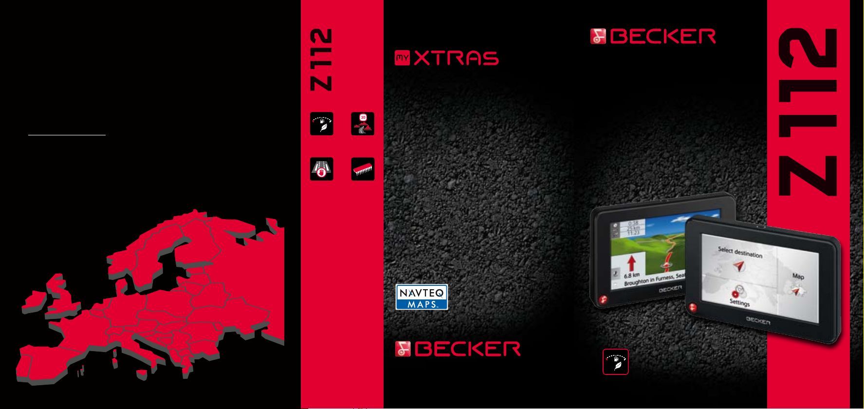
Z 112
Z 112
MEMORY
MEMORY
MEMORY
> 41 countries pre-installed
Included on NAVTEQ Database:
> A > AL > AND > B > BG > BIH > BY > CH > CZ> D > DK
> E > EST > F > FIN > FL > GB > GBZ > GR > H > HR > I
> IRL > L > LT > LV > MC > MK > MNE > N > NL > P > PL
> RO > RSM > RUS > S > SK > SLO > SRB > V
Special destinations: airports, hospitals, camping grounds,
alternative petrol stations, railway stations, hotels, restaurants,
sports stadiums, etc.
Economical
route
Permanent
road
blocks
Terrain
View
2 GB
2 GB Flash
Customise and create your
own personal Becker Satellite
Navigation system
www.mybecker.com/myxtras
Register now and take advantage
of our offers today!
TRAFFIC ASSIST
> 4.3” Touch-Screen
> European Navigation
> “45 Day Map Update” guarantee
> Economic route guidance
> 3D Terrain View
> Permanent road blocks
> Split-Screen
> Content Manager
> 4 alternative routes
SX-0Z112-02-020-1209 · All information is provided without warranty.
Technical specifications subject to change without notice. © 2009 Harman Becker · All rights reserved.
EUROPE
> info@mybecker.com
> www.mybecker.com
Economical
route
EUROPE
Page 2
BECKER TRAFFIC ASSIST Z 112
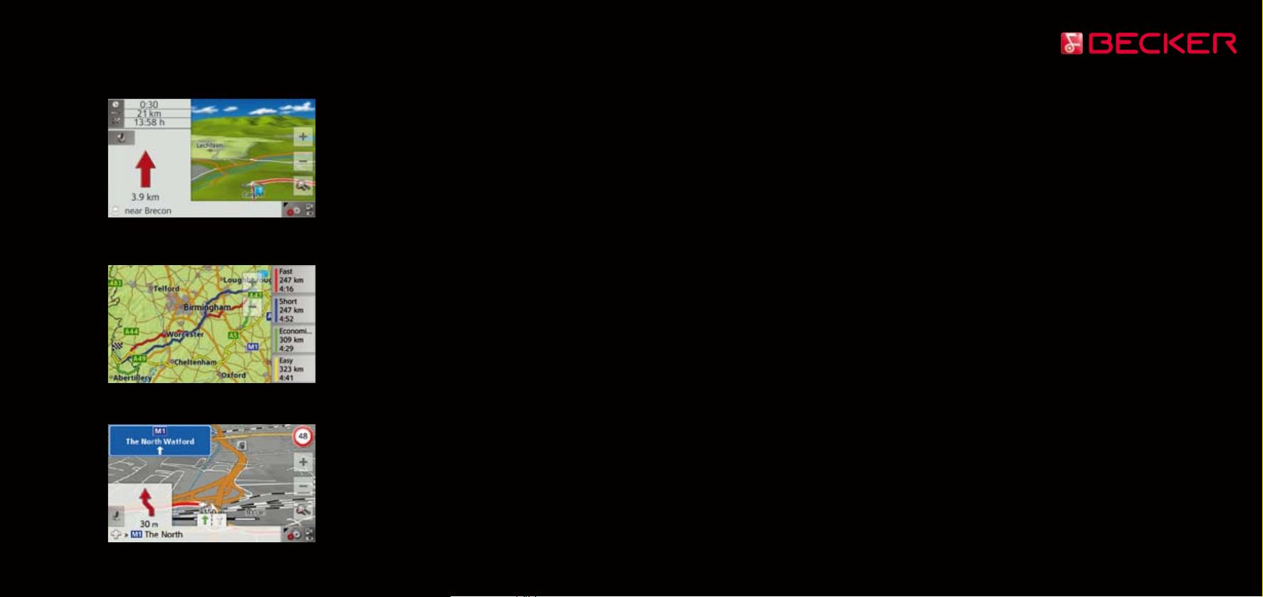
> 3D Terrain View & Split-Screen
> 4 alternative routes
> Traffic sign display
> TOP FEATURES
Economic route guidance: Using this
function, you save fuel and arrive at
your destination, having achieved the
optimum balance between journey time
and mileage.
“45 Day Map Update” guarantee:
guaranteed 45-day, free-of charge
map update service in the online store,
www.mybecker.com/myxtras
(only valid with online registration using
the enclosed software within 45 days
after initial operation).
Pre-installed traffic camera warning
database for: Belgium, Czech Republic,
Denmark, Finland, France, Ireland, Italy,
Luxembourg, Netherlands, Norway,
Poland, Portugal, Sweden, Spain, UK
3D terrain view: Three-dimensional
display of the local area, mountains,
valleys and landscapes. Road names
display.
Permanent road blocks: Option to
block roads and/or route sections
for a defined time, e.g. site-dependent
motorway blocks.
4 alternative routes: A choice of fastest,
shortest, economical or easiest route
options can be simultaneously displayed
and selected.
Traffic sign display: Images of traffic
signs with city names and directions
on European motorways are extremely
helpful, e.g. for frequent motorway
changes.
40:60 split screen with 2D and 3D modes,
offering more information. Includes a
progress bar regarding distance.
Content Manager: Enables automatic
configuration of navigation system with
DVD (included).
> SOFTWARE
Destination entry: alphabet/selection list,
entry/selection via touch-screen, entry
of postal code, 8 digital postal code, house
number, junctions, stopovers and POIs
Points of Interest along the way:
e.g. petrol stations and rest areas on
the calculated route.
Destination memory: memory for over
200 fixed and previous destinations
Route list: listing of individual road
changes in text form.
Route info: Display and announcement
of time of arrival, destination address,
intermediate destination address,
travel time remaining
Route options (with/avoid/without):
motorways, toll roads, ferries,
dirt roads, U-turns
Route selection: fast route, short route,
economical route, simple route
Route calculation: can be selected
according to profiles (normal car,
fast car, slow car, truck, motorcycle,
bicycle, pedestrian)
Route navigation: country-specific
announcements, choice of languages
(BG, CY, CZ, D, DK, E, EE, F, FIN, GB, GR,
HR, HU, I, LT, LV, N, P, PL, RO, RU, S, SK,
SLO, SRB, TR, UA, Vlaams)
Turn-by-turn navigation: navigation
instructions displayed with arrows.
Improved readability for two-wheel
vehicles.
Lane info: lane assistance
(guidance for recommended lane).
Speed Limit: graphic display of legal
speed limits; acoustic warning when
limit is exceeded (adjustable)
View: Day/Night display for optimal
legibility, Brightness manually adjustable
for both day and night, automatic dimming
of backlight in tunnels with route guidance
activated, 2D/3D/Zoom, icon display
of Points of Interest, country-specific
information at border crossings
> HARDWARE
Performance: 400 MHz Processor
Memory: Internal 2 GB Flash memory
with 41 European countries pre-installed
GPS: SIRF Star III GPS receiver
Automatic On/Off: unit turns on and
off with ignition switch (vehicles with
switched cigarette lighter only)
Display: 4.3-inch TFT touch-screen 16:9
with 24 bit colour depth,
16.7 million colours.
Dimensions: (W x H x D)
126,4 mm x 81,6 mm x 18 mm
Weight: 165 g
> CONNECTIONS
Connections: headphone jack,
connection cable for cigarette lighter
socket (12 V/24 V)
USB: Mini USB, chargeable by Mini USB
interface or cigarette lighter
Micro-SD card slot
> PACKAGE CONTENTS
Traffic Assist Z 112, universal mounting
system, USB cable for PC connection,
a 12V/24V cigarette lighter charging
cable, Content Manager DVD incl. map
data (41 countries) and full instruction
manual, Quick Start instruction manual
> OPTIONAL
Media player: Display of elapsed track
time, directories, ID-3 tags
(title and artist). Compression formats:
MP3/WMA, MPEG4/MPEG2, JPG.
Simultaneous navigation announcements
and music reproduction.
> Upgrade option via online store
www.mybecker.com/myxtras
110 – 230 V battery charger
Bag
 Loading...