

Page 1

Aerosoft
Mega Airport
Berlin-Brandenburg
Page 2

Aerosoft Mega Airport Berlin Brandenburg 1.10
CONT E NTS
CONTENTS .............................................................................................................................................................. 1
INTRODUCTION ...................................................................................................................................................... 2
COPYRIGHTS ........................................................................................................................................................... 2
CREDITS................................................................................................................................................................... 3
SYSTEM REQUIREMENTS ........................................................................................................................................ 3
CONTACT SUPPORT ................................................................................................................................................ 4
INSTALLATION AND REMOVAL ............................................................................................................................... 4
FINDING THE AIRPORT IN FSX ................................................................................................................................. 4
VFR GERMANY COMPATIBILITY .............................................................................................................................. 4
MANAGER TOOL ..................................................................................................................................................... 5
FSX DISPLAY SETTINGS ............................................................................................................................................ 7
GRAPHICS MENU ............................................................................................................................................... 7
SCENERY SETTINGS ........................................................................................................................................... 8
TRAFFIC SETTINGS ............................................................................................................................................. 9
AIRCRAFT AND WEATHER SETTINGS ............................................................................................................... 10
PREPAR3D V2.2 DISPLAY SETTINGS ...................................................................................................................... 11
GRAPHICS MENU ............................................................................................................................................. 11
SCENERY SETTINGS ......................................................................................................................................... 12
LIGHTING SETTINGS ........................................................................................................................................ 13
TRAFFIC SETTINGS ........................................................................................................................................... 14
WEATHER SETTINGS ........................................................................................................................................ 15
INFORMATION FOR BERLIN BRANDENBURG INTERNATIONAL ............................................................................ 16
RADIO COMMUNICATION FREQUENCIES ....................................................................................................... 16
RUNWAYS ....................................................................................................................................................... 16
NAVIGATION ......................................................................................................................................................... 16
VOR + DME ...................................................................................................................................................... 16
ILS .................................................................................................................................................................... 17
FURTHER INFORMATION ABOUT NAVAIDS AND TEMPELHOF AIRPORT ........................................................ 17
GATES AND STANDS ............................................................................................................................................. 18
NON AVAILABLE GATES/STANDS USING ATC .................................................................................................. 18
NOMENCLATURE ............................................................................................................................................. 18
STOP POSITIONS AND AIRCRAFT TYPES .......................................................................................................... 18
ABOUT PREPAR3D ................................................................................................................................................ 21
F.A.Q. .................................................................................................................................................................... 22
APPENDIX A : MAP BER/SXF AREAS ...................................................................................................................... 24
APPENDIX B: CHARTS ............................................................................................................................................ 25
Page 1
Page 3

Aerosoft Mega Airport Berlin Brandenburg 1.10
INT R O D UCTION
Say what you want but Berlin Brandenburg International airport's conception was not without problems.
Scheduled to open in 2010 it now looks like 2016 might be possible if there are no new problems. The delays,
which weigh heavily on the proverbial German reliability, had many causes, not all of them under control of
the management. It’s located next to Schönefeld airport and when completed will replace Schönefeld
and Berlin Tegel Airport as the main airport for Berlin.
This special scenery project shows the current situation of the airport (as in early 2014) but using the
management tool you can open the new airport and see the bright future this airport most certainly has (set
by default).
The fact the airport is not open right now made the development a bit easier. Sascha Normann had the great
fortune not only to have a complete tour of the airport to make photos but also a few aerial tours with
maneuvers permitted by the tower that would never be possible over an operational airport this size!
It all adds up to an airport that is not like most others. It is absolutely state-of-the-art, using all the new
technology available. The combined efforts of LimeSim and 29Palms, both highly respected development
teams are behind this project. It’s some of the finest work Aerosoft has published and we are happy to
introduce you to Berlin Brandenburg Willy Brandt International Airport.
COPYR I G HTS
The manual, documentation, video images, software, and all the related materials are copyrighted and cannot
be copied, photocopied, translated or reduced to any electronic medium or machine legible form, neither
completely nor in part, without the previous written consent of AEROSOFT. THE SOFTWARE IS FURNISHED «AS
IS» AND IT DOES NOT COME FURNISHED WITH ANY GUARANTEE IMPLICIT OR EXPRESS. THE AUTHOR DECLINES
EVERY RESPONSIBILITY FOR CONTINGENT MALFUNCTIONS, DECELERATION, AND ANY DRAWBACK THAT
SHOULD ARISE, USING THIS SOFTWARE.
Copyright © 2014 AEROSOFT/ LimeSim / 29Palms. All rights reserved. Microsoft Windows, and Flight Simulator
are registered trademarks or trademarks of Microsoft Corporation in the United States and/or other Countries.
All trademarks and brand names are trademarks or registered trademarks of the respective owners. Copyrights
are serious stuff. If you find any pirated copies of this software please notify us at support@aerosoft.com. We
will make sure reports of copyrights violation are rewarded.
Aerosoft GmbH
Lindberghring 12
D-33142 Büren
Germany
www.aerosoft.com
Page 2
Page 4

Aerosoft Mega Airport Berlin Brandenburg 1.10
CRED I T S
Concept: LimeSim
Modelling of BER Terminal area: LimeSim
Modelling of bridges/VFR objects: LimeSim
Modelling of SXF airport area: 29Palms
Modeling of all other structures: 29Palms
Modelling of ground layout: LimeSim
Rwy/Twy/Approach-Lights: Oliver Pabst / LimeSim
AESLite Train, road and apron traffic: Oliver Pabst
Mesh terrain: LimeSim
Autogen placement: LimeSim
AFCAD: LimeSim
Management Tool: 29Palms
Aerial imagery source: © Astec GmbH
Aerial imagery editing: LimeSim / 29Palms
Static ground vehicles and people: 29Palms, Aerosoft and associated developers
Project Management: LimeSim, Mathijs Kok (Aerosoft)
Manual, documentation: LimeSim, Mathijs Kok (Aerosoft)
Installer: Andreas Mügge
Testing: Several good folks who will all be getting a copy
Thanks to:
Pilots of the Aerolight Flugschule in Strausberg for an excellent job flying us over a busy airport in
ultralights with open windows while explaining our wishes to the tower and doing the right turns
when needed.
Deutsche Flugsicherung (DFS). Their tower controllers in BER for permitting us to do unusual
maneuvers to get the right shots. And their office guys for giving is the input needed to make this
airport as realistic as possible.
Flughafen Berlin Brandenburg GmbH for their “VIP” airport tour and supplying further information
needed.
FS legend Mike Strasser (FS Magazin) for providing valuable input and feedback in creating AFCAD
files.
And last but not least: The fantastic guys from VATSIM Germany for supplying us with charts for BER
that actually don't exist yet!
SYS T E M REQUIREMENTS
3.0 GHz CPU (Intel Core2 Duo advised)
4 GB RAM
Direct X 9 compatible Graphics Card with minimal 1 Gb memory
Microsoft FSX (with SP2 or Acceleration), Prepar3D 1.4 or Prepared 2.2
Windows XP, Windows VISTA, Windows 7, Windows 8 (fully updated), 64 bit version highly
recommended
Adobe Acrobat® Reader 8 minimal to read and print the manual (1)
(1)
Available for free, download at: http://www.adobe.com/prodindex/acrobat/readstep.html
Page 3
Page 5
Aerosoft Mega Airport Berlin Brandenburg 1.10
CONT ACT SUPPORT
Support for this product is done by Aerosoft. We prefer to do support on the support forum for one simple
reason, it is fast and efficient because customers help customers when we are sleeping.
Aerosoft forums: http://www.forum.aerosoft.com/
We feel strongly about support. Buying one of our products gives you the right to waste out time with
questions you feel might be silly. They are not.
INS T ALLATION AND REMOVAL
Installation is simple. Unzip the file that you downloaded and start the exe file you downloaded and follow the
instructions on your screen. Make sure FSX is closed and we do advise you to reboot your system before
installing. Make sure you are logged on as Administrator on the machine! After installing it can help to
defragment your hard disk. Do note that the files are personalized on installation. When you share them with
others you also share personal details.
After installation has finished the Aerosoft Launcher will can be installed. This is fully optional but will assist
you in managing and updating Aerosoft products.
Removal should never be done manually but only using the software removal applet you will find the Windows
Control panel.
FIN D I N G THE AIRPORT IN FSX
You will find the airport using either the city name (Berlin) or the airport ID (EDDB).
VFR G ERMANY COMPATIBILITY
When installing, “Mega Airport BER” will look for an installed version of “VFR Germany – East” and will install
the respective files to make both add-ons compatible.
In case you install “VFR Germany- East” after you installed “Mega Airport BER”, you will need to make sure a
few files are swapped. This can be done easily by using the “VFR Germany Compatibility” tool provided in the
Windows Start Menu (Aerosoft | Mega Airport BER ).
Please note you should not use the season switch in the Manager Tool to switch to winter when using “VFR
Germany – East”. The “VFR Germany” products do not contain any winter textures, which would make BER a
while “island” within the VFR Germany landscape.
Page 4
Page 6
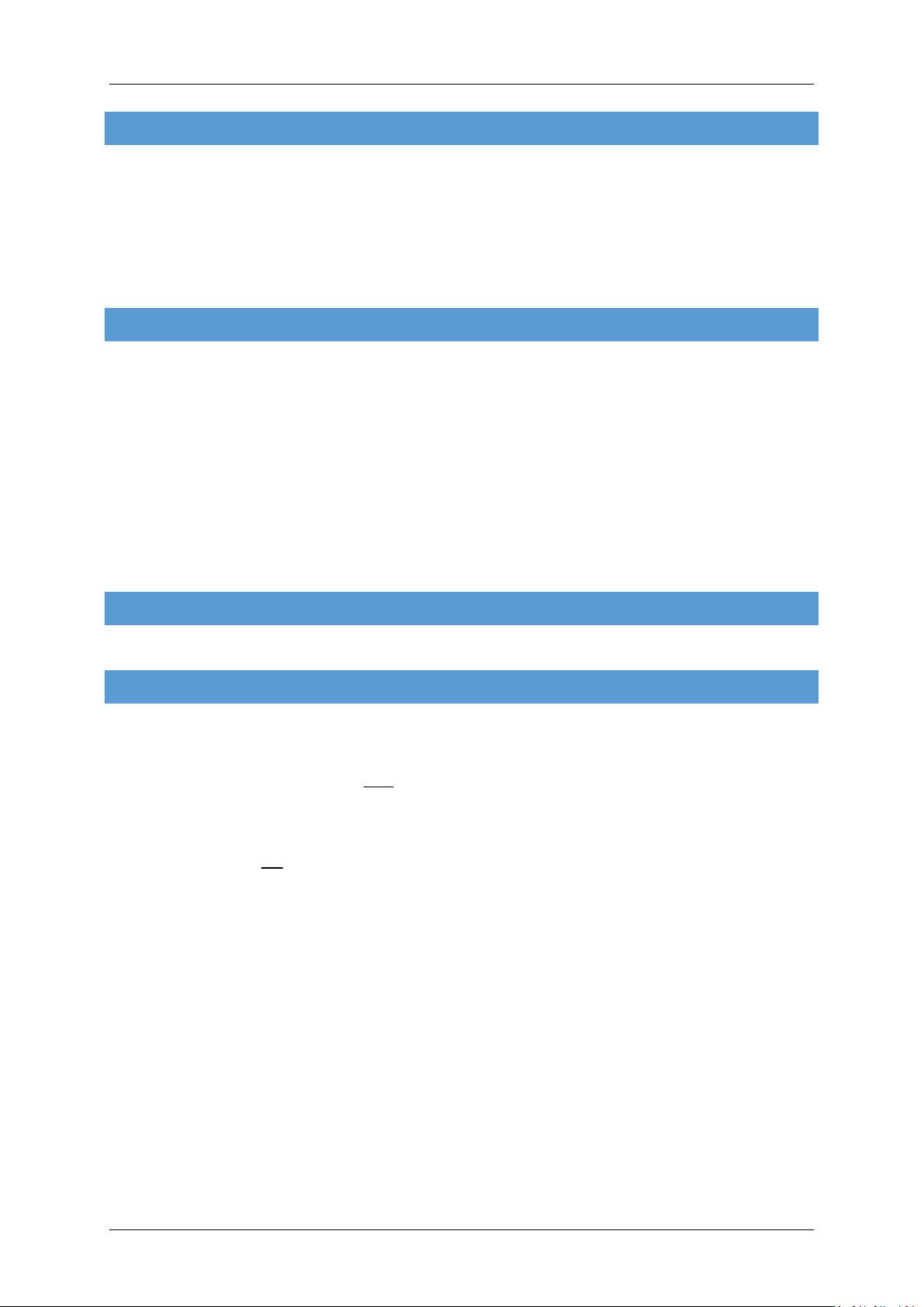
MANA GER TOOL
Aerosoft Mega Airport Berlin Brandenburg 1.10
There are many elements of this scenery that you can toggle on or off. You can find the Manager Tool in the
Windows Start Menu (Aerosoft | Mega Airport BER) or you can start it via the Aerosoft Launcher.
BER active: This setting enables you to activate the BER areas of the airport and the respective
navaids (ILS) which have not been put in service yet (April 2014). This is the scenery's default setting.
If you deactivate this option, all structures within the BER area will visually show as they currently are
and only the SXF part will be used for aviation. There will be a fence across the main BER apron and
only BER's north pier parking positions will be available. In addition those around the actual SXF
terminal of course. See Appendix 1 to get a better idea of the areas covered.
Texture Max Load: FSX only! Not needed for Prepar3D, see settings chapter!) Mega Airport BER uses
textures at a higher (HD) resolution textures than you can load them in FSX by default. Therefore we
highly suggest that you set Texture Map Load to 2048 to have the best visual experience. Higher
settings like 4096 won't make any difference for Mega Airport BER.
Ground Lighting: Set to “Half” by default. Ground lighting has a major impact on FPS even on high end
systems. Which is the reason why you should not use the “Full” setting unless you really want to.
“Full” will show each taxi light at its real world position and there are plenty of those...
3D Grass: Although it looks really good, 3D grass will take up a lot of FPS so it is best left off on
systems that are not very powerful.
Season Switch: Please use this switch to activate winter textures when flying during the months of
December, January and February so they merge perfectly with the surrounding snow landscape (not
recommended for VFR Germany users since there are no winter textures in that product).
IMPORTANT! Once you make any changes to the settings in FSX, FSX will reset your TML settings made in
the Manager Tool to 1024 or lower! Therefore it is highly recommended to shut down FSX after you made
your setting changes, open the Manager Tool, set TML back to 2048 and restart FSX. This will ensure that
both your new settings made and TML=2048 will be used by FSX.
Page 5
Page 7
Aerosoft Mega Airport Berlin Brandenburg 1.10
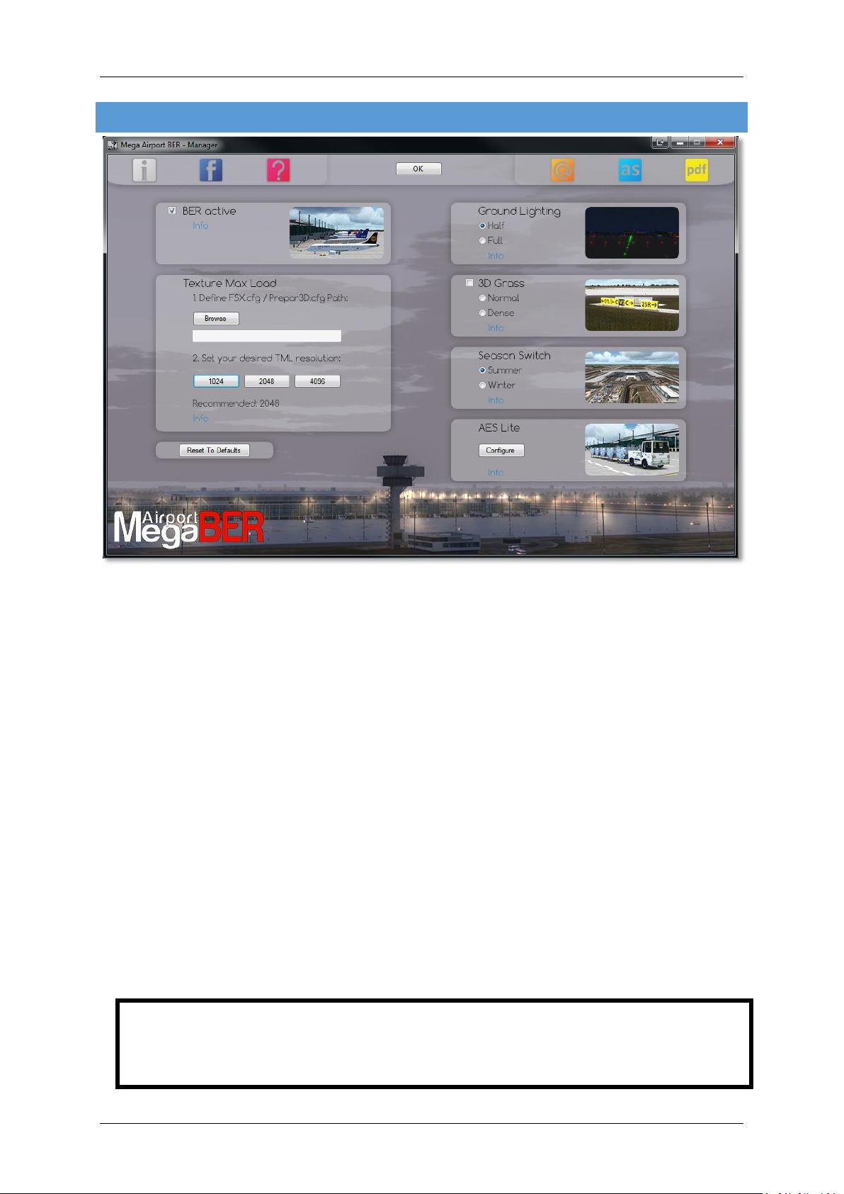
AES Lite: (FSX only! See chapter “About Prepar3D”) Will let you toggle on/off traffic around the
aprons, roads as well as trains on the extensive network around the airport. Note: The DX10 option is
only intended for daytime use and will make all vehicles compatible to the DX10 Preview mode
available in your FSX. They won't however show properly at night.
Page 6
Page 8
Aerosoft Mega Airport Berlin Brandenburg 1.10
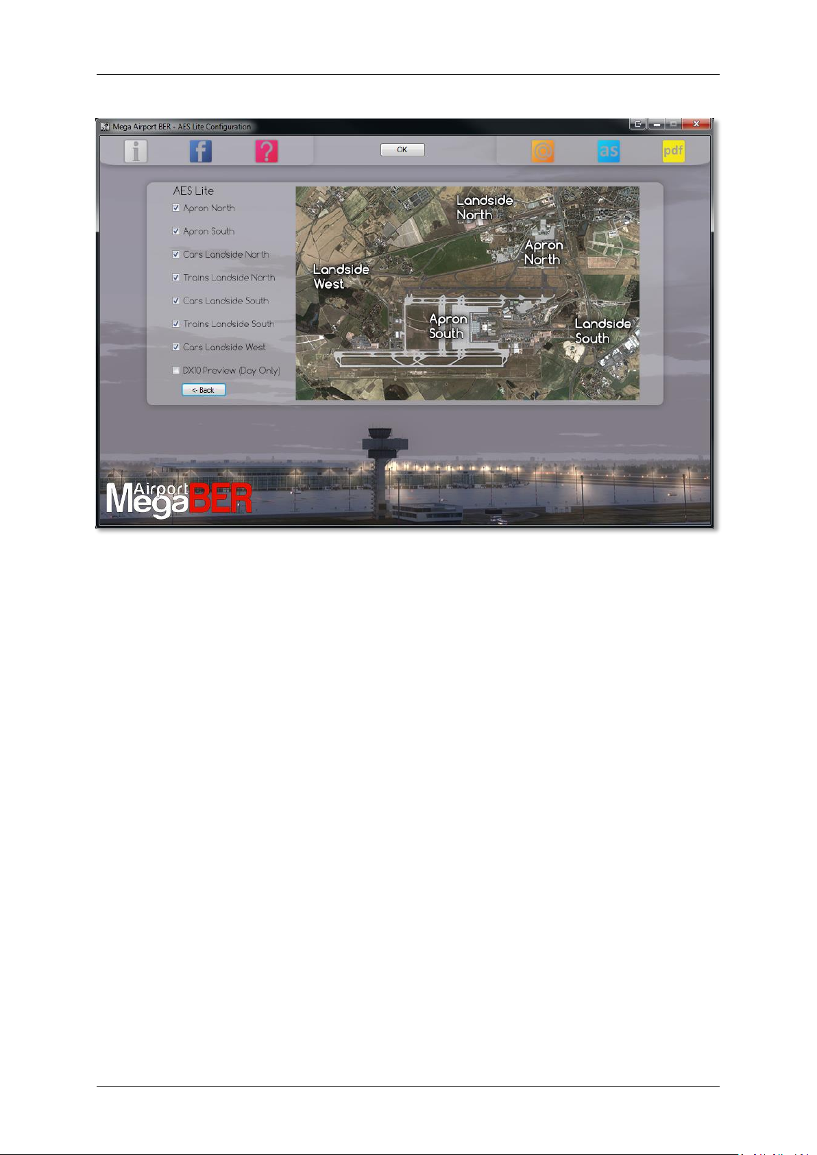
FSX D I S P L AY SETTINGS
In order to change your scenery settings, go to Settings -> Display. All settings that are important to see this
scenery correctly are marked in red. All other settings are to your own liking.
IMPORTANT! Once you make any changes to the settings in FSX, FSX will reset your TML settings made in the
Manager Tool to 1024 or lower! Therefore it is highly recommended to shut down FSX after you made your
setting changes, open the Manager Tool, set TML back to 2048 and restart FSX. This will ensure that both your
new settings made and TML=2048 will be used by FSX.
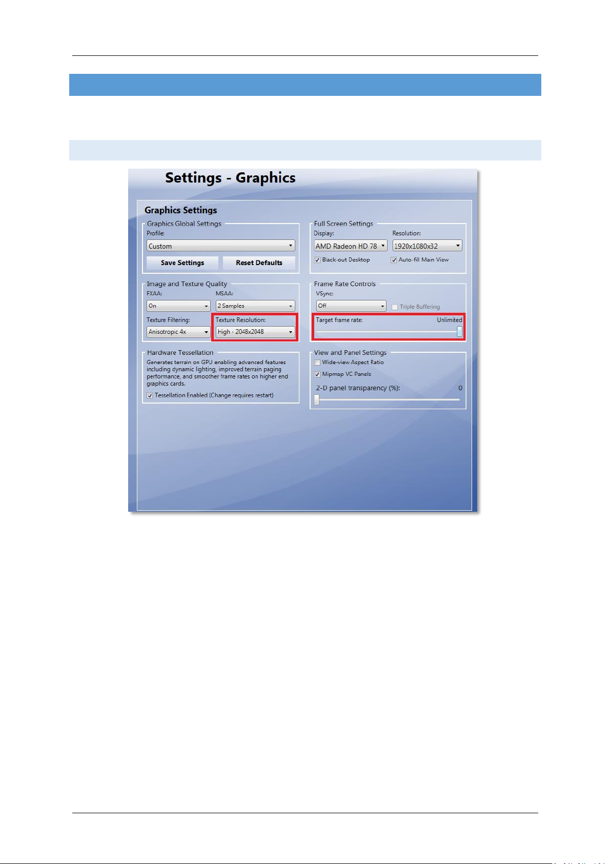
GRAPH ICS MENU
We advise to keep Target frame rate set to Unlimited when your hardware is not very fast. If you see
your frame rate wildly fluctuating and over 50 fps we advise you to limit the frame rates to 40. This
will allow FSX to calculate a few things in advance.
Global texture resolution has to be to Very high.
See the advice at the beginning of this chapter. This is the TML setting. The slider can't go beyond
“very high” (1024 pix) while the Manager Tool provided can (2048 pix recommended)
Page 7
Page 9
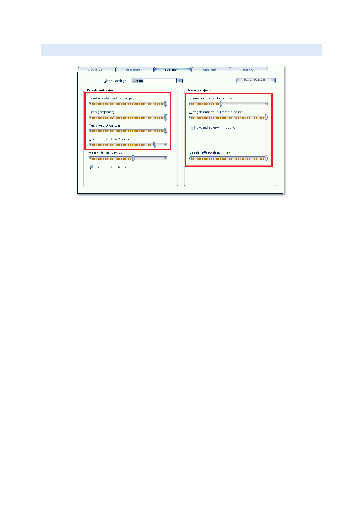
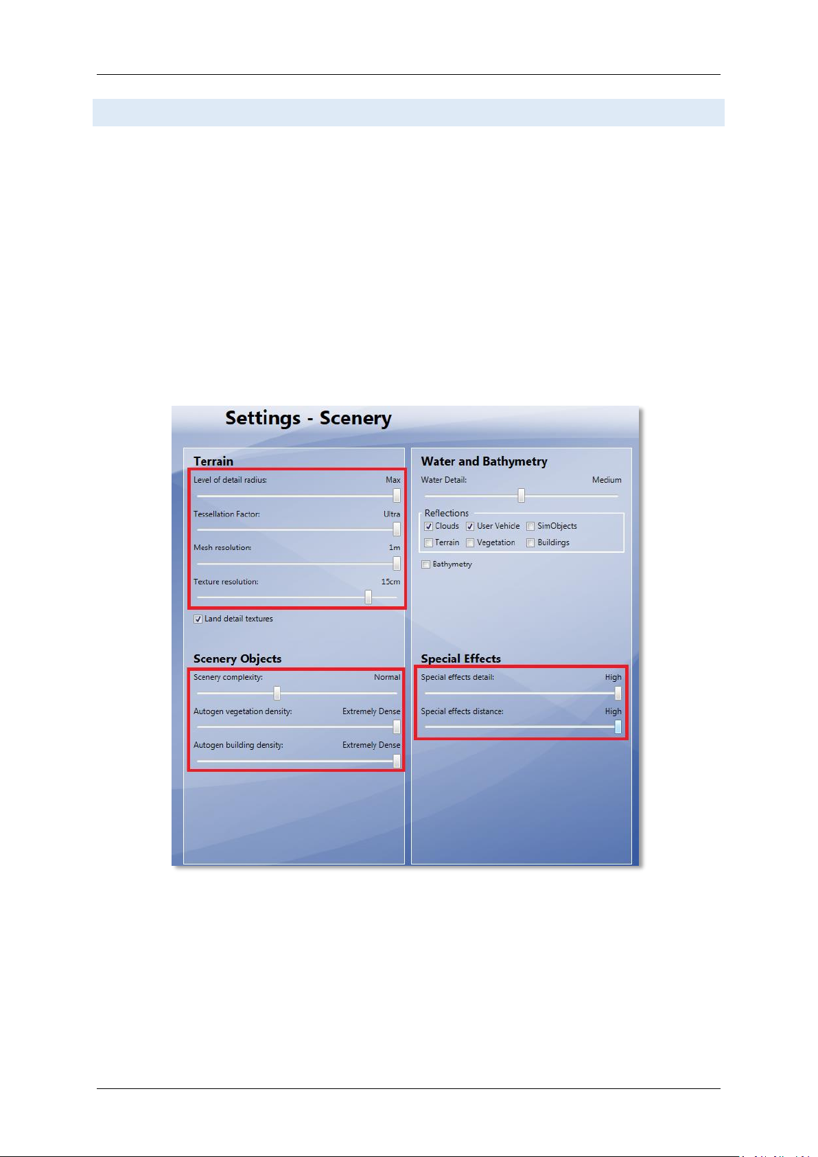
SCE N E RY SETTINGS
Aerosoft Mega Airport Berlin Brandenburg 1.10
Level of detail radius should be set to Large to have nice crisp ground textures outside the areas
covered by concrete and asphalt.
Mesh is important for this scenery. Set Mesh Complexity to 100 and Mesh resolution to 1 meter.
Texture resolution should be at least 15 cm or less to get the best resolution of the textures.
Special effects details should be on High to see all the special animations.
Scenery complexity can be set to Normal. All the airport's structures will be shown at that setting.
For best results we recommend to set Autogen Density to Extremely dense to show every single
house around the airport. If you do airliner flights (meaning no VFR flying around the airport) we
recommend to bring it down a bit, e.g. Normal.
IMPORTANT: If you encounter “Out of Memory” (OOM) crashes, we recommend to move this slider a
bit further to the left since autogen uses a lot of memory!
Also, do make sure that ground scenery shadows box is Off, since all 3D objects have built-in shadows
for better performance
Page 8
Page 10
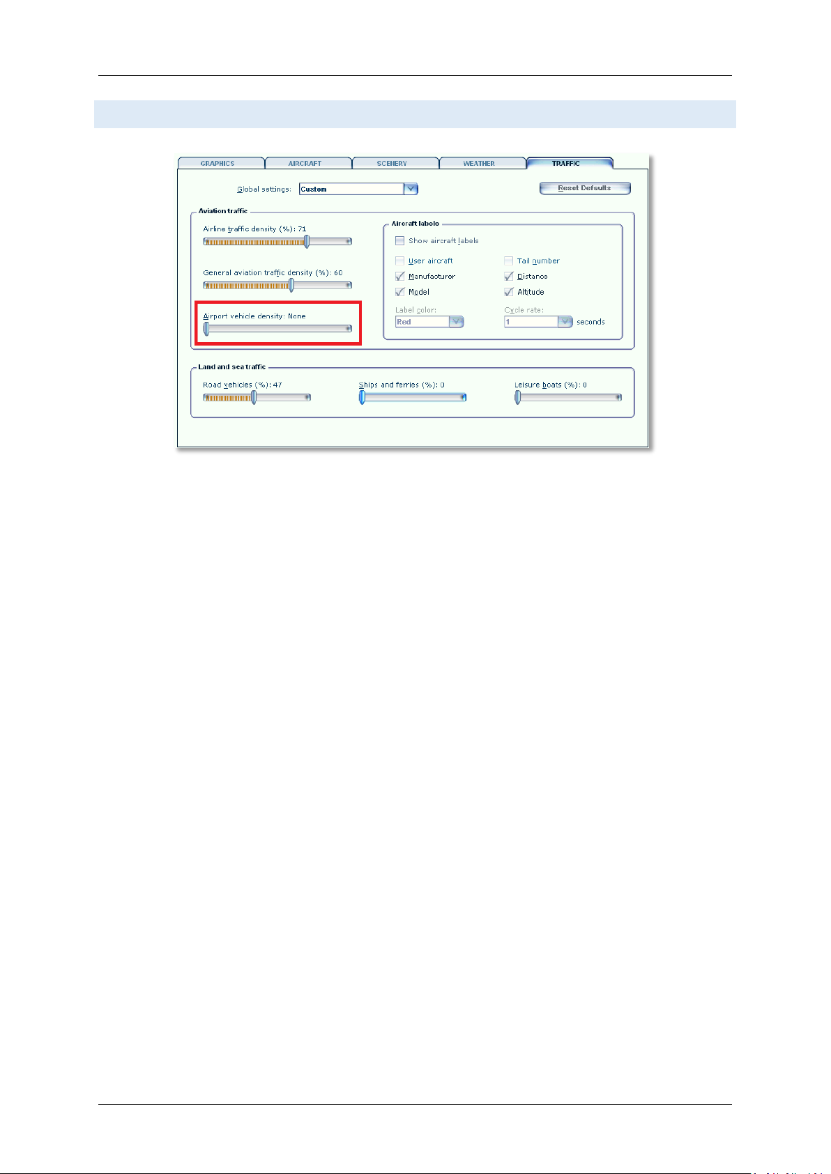
TR AF FI C SE TTIN GS
Aerosoft Mega Airport Berlin Brandenburg 1.10
Traffic settings as shown are advised. This will make the project look best and will avoid
problems.
Page 9
Page 11
Aerosoft Mega Airport Berlin Brandenburg 1.10
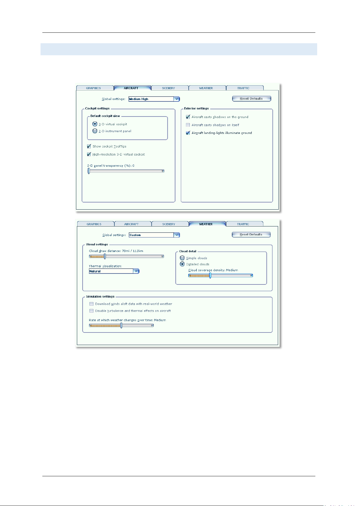
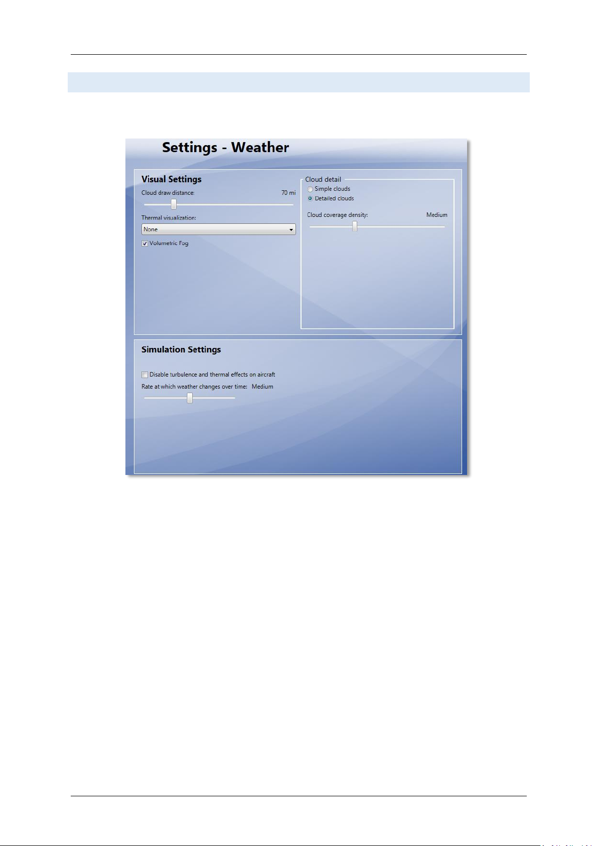
AIRCRAFT AND WEATHER SETTINGS
Aircraft and weather settings are not very important for a scenery but for completion we added the settings
our testers found to be most suitable.
Page 10
Page 12
Aerosoft Mega Airport Berlin Brandenburg 1.10
PREPAR 3 D V 2 .2 DISPLAY SETTINGS
In order to change your scenery settings, go to Options → Settings → Display. All settings that are important to
see this scenery correctly are marked in red. All other settings are to your own liking.
GRAPH ICS ME NU
We advise to keep Target frame rate set to 40. This will allow P3D to calculate a few things in
advance and will avoid wildly fluctuating fps.
Global texture resolution has to be High
This is the same as the TML setting in the Manager Tool and for P3D does not need to be altered
in the Manager Tool individually.
Page 11
Page 13
SCE N E RY SE TTINGS
Level of detail radius should be set to Large to have nice crisp ground textures outside the areas
covered by concrete and asphalt.
Mesh is important for this scenery. Set Tessellation factor to Ultra and Mesh resolution to 1
meter.
Texture resolution should be at least 15 cm or less to get the best resolution of the textures.
Special effects details should be on High to see all the special animations.
Scenery complexity can be set to Normal. All the airport's structures will be shown at that
setting.
For best results we recommend to set Autogen Density for both vegetation and buildings to
Extremely dense to show every single house around the airport. If you do airliner flights
(meaning no VFR flying around the airport) we recommend to bring it down a bit, e.g. Normal.
IMPORTANT: If you encounter “Out of Memory” (OOM) crashes, we recommend to move this
slider a bit further to the left since autogen uses a lot of memory!
Aerosoft Mega Airport Berlin Brandenburg 1.10
Also, do make sure that ground scenery shadows box is Off, since all 3D objects have built-in shadows
for better performance
Page 12
Page 14
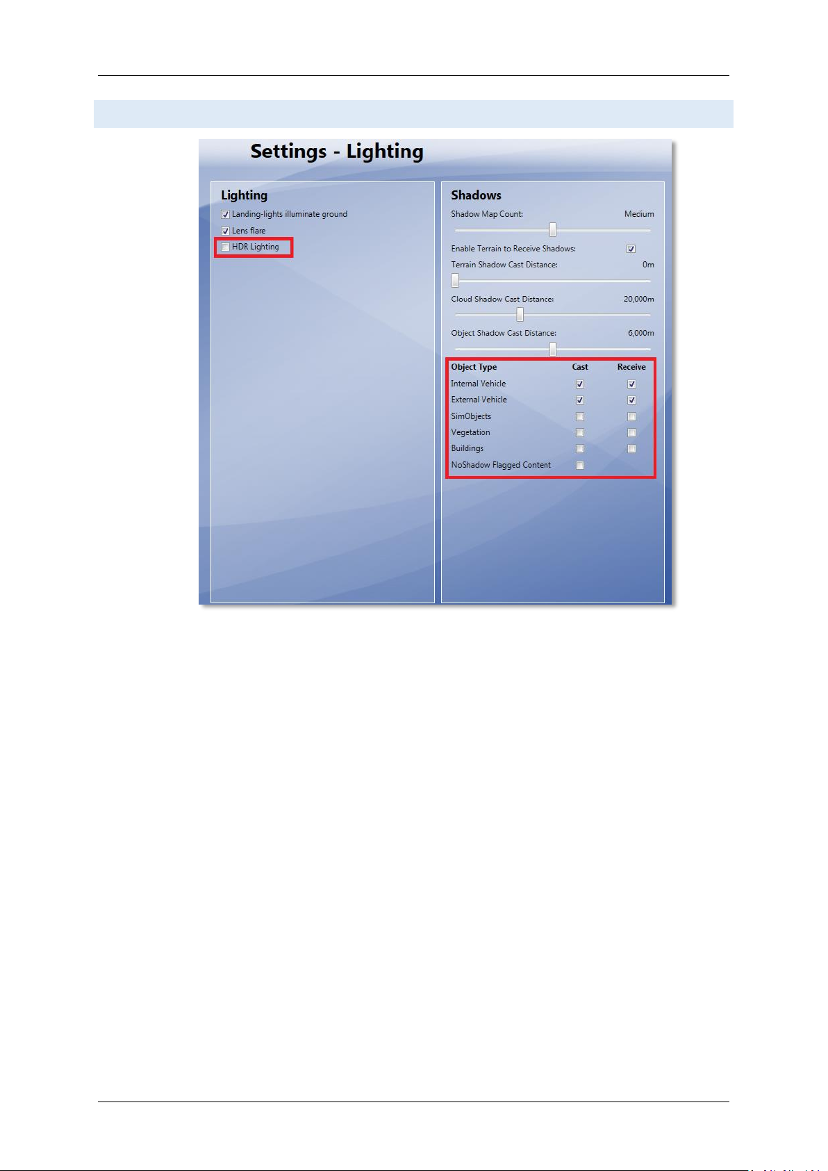
LIGHTING SETTINGS
Aerosoft Mega Airport Berlin Brandenburg 1.10
HDR Lighting should be switched off since this causes the scenery to be unrealistically dark and pitch
black at night.
Scenery shadows for scenery objects can be turned off since this scenery comes with shadows
rendered into the textures to allow a better performance.
Page 13
Page 15
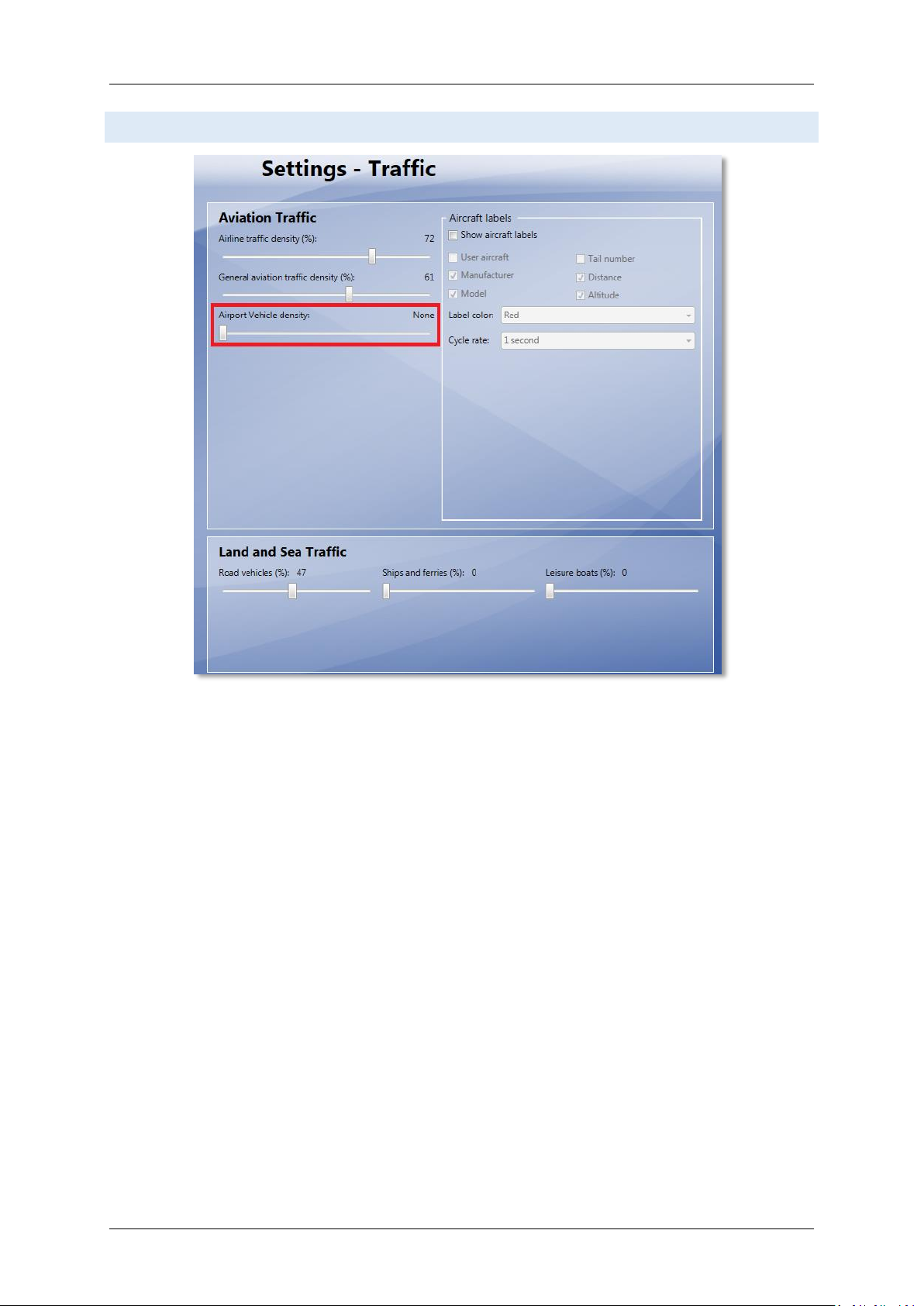
TRAFFIC SETTINGS
Aerosoft Mega Airport Berlin Brandenburg 1.10
Traffic settings as shown are advised. This will make the project look best and will avoid problems.
Page 14
Page 16
Aerosoft Mega Airport Berlin Brandenburg 1.10
WEATHER SETTINGS
Weather settings are not very important for a scenery but for completion we added the settings our testers
found to be most suitable.
Page 15
Page 17

Aerosoft Mega Airport Berlin Brandenburg 1.10
INF O R M ATION FOR BERLIN BRA ND ENBURG INTERNATIO N A L
Airport: Berlin Brandenburg International “Willy Brandt” (before opening: Berlin-Schönefeld)
Country: Germany
City: Berlin
ICAO ID: EDDB
IATA ID: BER (before opening SXF)
Time: UTC+1(+2DT)
Location: 52°21'43"N (52.362137) 13°30'00"E (13.500070)
Elevation: 148 feet (45 meters)
Type: Civil
Magnetic Variation: 003° E
RAD IO CO MM UN I CATION FRE Q UE N CIE S
Tower 120.025 / 119.575
ATIS 123.775
Ground 129.5
RUN WAYS
Runway 07R: 4000 x 60 meters (13123’ x 197’ feet) Concrete
o Lights: W VRB LIH/LIL PAPI-L (3.00°)
Runway 07L: 3000 x 45 meters (9843’ x 148’) Asphalt , displaced threshold
o Lights: W VRB LIH/LIL PAPI-L (3.00°)
NA V IG ATION
VOR + DME
ID: BER
Name: BERLIN BRANDENBURG
Frequency: 114.100
Range: 80NM
Location: 52°20'31"N (52.342014089) 13°27'15"E (13.454047143)
ID: SSD
Name: SCHONEFELD
Frequency: 114.400
Range: 195.05NM
Location: 52°22'28"N (52.374525145) 13°30'13"E (13.503672034)
Page 16
Page 18

Aerosoft Mega Airport Berlin Brandenburg 1.10
Runway: 07R
ID: IBSE
Frequency: 109.7
Range: 25NM
Glideslope: 3°
Runway: 25L
ID: IBSW
Frequency: 109.5
Range: 25NM
Glideslope: 3°
Runway: 25R
ID: IBNW
Frequency: 109.9
Range: 25NM
Glideslope: 3°
Runway: 07L
ID: IBNE
Frequency: 110.7
Range: 25NM
Glideslope: 3°
ILS
FURTHER INFORMATION ABOUT NAVAIDS AND TE MPELH O F A I R P O R T
The Berlin Airspace has changed a lot since the initial release of MS Flight Simulator X. Therefore some changes
to the navaids available were necessary. Although a developer should never make changes to another airport
than the one he is working on we needed to make some changes to Tempelhof airport. That is that old historic
airport north of BER (within city limits) that has sadly been closed a few years ago despite its long history
(famous for the Berlin Air Bridge).
Unfortunately the new BER south runway and BER VOR will use the same frequencies as they were in use by
Tempelhof and still are in FSX. Therefore we went ahead and removed those ILS and VOR navaids from
Tempelhof. And while we were at it we closed its runway for traffic and marked them with an “X” to keep
things as realistic as possible.
Btw: “Removing” is not the right term here to be precise. FSX does not allow us to remove existing navaids.
Therefore we had to “orphanize” them. Which means we moved them away from Tempelhof and set them to
a test frequency of 108.0 (ILS) and 110.0 (VOR). Unless you use that test frequency, you won't see those old ILS
navaids anymore but they are still visible in the FSX Map window a few miles north (they don't serve a purpose
there).
Page 17
Page 19
Aerosoft Mega Airport Berlin Brandenburg 1.10
B16
C05A
D17
26
B09A
C07A
D18
23
B11A
C09A
D19
20
B13A
C11A
D20
52
B08
C14
D02
56
B05A
D03
58
B03A
D04
B01A
D05B
D05
D06
D07 D08
D21
D20
D13A
D13B
D14
D15
D16
D09 D10
D11
GAT E S AND STANDS
NON AVAILABLE GATES/STANDS U S I N G A T C
To avoid conflicts between AI aircraft and your aircraft we were not able to add all gates and stands that
overlap with others to the AFCAD file. Although they are all visually there, FSX's ATC will never guide you to the
following gates and stands (which also means you won't be able to select them as start location in the airport
menu):
NOMENCLATURE
To match FSX's nomenclature all gates and stands with a letter extension were renamed as in the following
sample (again: This only affects the ATC and airport menu. Visually their letters and numbers painted on the
ground will show as in real world):
B15A → B151
B15B → B152
STOP POSITION S AN D AIRCRAFT TYPES
The following list of nose wheel stop locations at the gates may help you to find the right gate for your aircraft
type. This will be of particular interest for pilots participating on online sessions when all gates can be used
without interfering AI traffic.
Page 18
Page 20

Aerosoft Mega Airport Berlin Brandenburg 1.10
Please note this list only contains gates and stands within the BER aprons, not for the SXF apron. The visual
placement of the stop positions at SXF is based on an internal list provided by the airport, which we are not
allowed to share with others. While the BER locations are based on our own aerial shots taken in autumn
2013. Interestingly those locations have changed 2-3 times in the past years even though the airport wasn't
open yet!
A01-A12:
STOP 1: MD80/90
STOP 2: A321,B717,MD87,CRJ700/900,B734,B738,B739
STOP 3: A320,B733,B737,ERJ170-195,F100
STOP 4: A318,A319,B736,B735,RJ70-100
B01-B07, B09-B15:
STOP 1: A320,A321,F100,B733-B739,ERJ170-195
STOP 2: A318,A319,RJ70/85/100,MD80/90
B01A:
STOP 1: A346,A351,B764,B748,B733
STOP 2: B744,B789,A359
STOP 3: A333,A358,A342-A345,B757,B763,B772,B783,B788
STOP 4: A332,B762
STOP 5: A300,A310
B05A,B07A,B11A,B13A,B15A:
STOP 1: A346,B748,B773,A351,B764
STOP 2: B744,B789,A359
STOP 3: A333,A358,A342-A345,B757,B763,B772,B783,B788
STOP 4: A332,B762
STOP 5: A300,A310
B07B, B15B, D05B, D13B:
STOP 1: A380
B08,D12:
STOP 1: B763,B783
STOP 2: A300,B762
STOP 3: A310,B757
STOP 4: A321,B734,B738,B739
STOP 5: A320,F100,RJ70/85/100,MD80/90,ERJ170-195,B733,B737
STOP 6: A318,A319,B735,B736
B09A:
STOP 1: A346,B748,B773,A351,B764,A380
STOP 2: B744,B789,A359
STOP 3: A333,A358,A342-A345,B757,B763,B772,B783,B788
STOP 4: A332,B762
STOP 5: A300,A310
Page 19
Page 21

Aerosoft Mega Airport Berlin Brandenburg 1.10
B16:
STOP 1: A321,A320,B733,B734,B737-B739,MD80/90,F100
STOP 2: RJ85,RJ100,B735,B736,ERJ170-195
STOP 3: A318,A319,RJ70
C01-C02:
STOP 1: MD80/90
STOP 2: A321,B717,B734,B738,B739,MD87,CRJ700/900
STOP 3: A320,B733,B737,ERJ170-195,F100
STOP 4: A318,A319,B735,B736,RJ70-100
C03:
STOP 1: A345
STOP 2: B744
STOP 3: B764,B772,B789
STOP 4: A333,A343,A358,B763,B783,B788
STOP 5: A332,A342,B762
STOP 6: A300,A310,B753
STOP 7: B752,MD80/90
STOP 8: B321,B717,MD87
STOP 9: A320,B733-B739,F100,RJ70/85/100,CRJ700-1000,ERJ145,ERJ170-195
STOP 10: A318,A319
C04,C12,C13:
STOP 1: B753,B763
STOP 2: A300,B762
STOP 3: A310,B752,MD80/90
STOP 4: A320,A321,F100,B733-B739,B717,MD87,ERJ170-195
STOP 5: A318,A319,RJ70/85/100,CRJ700-1000,ERJ145
C05A,C07A,C09A,C11A,C14A:
STOP 1: A345
STOP 2: B744,B764,A359
STOP 3: B763,B772,B789
STOP 4: A332/333,A342/343,A358,B753,B783,B788
STOP 5: - not used STOP 6: A300,A310,B752,B762
C05-C11,C14:
STOP 1: A320,A321,B733-B739,MD80/90
STOP 2: ERJ170-195
STOP 3: A318,A319,RJ70/85/100,CRJ700/900,ERJ145
C15:
STOP 1: - not used STOP 2: B753,B763,B783
STOP 3: A300,B752,B762
STOP 4: A310,A321,B717,B734,B738,B739,MD80-90
STOP 5: A320,B733,B735-737,ERJ145,ERJ170-195,F100,CRJ700-1000
STOP 6: A318,A319,RJ70-100
Page 20
Page 22

Aerosoft Mega Airport Berlin Brandenburg 1.10
D01,D03A,D05A,D07A,D09A,D11A,D13A,D15A,D17A,D19A,D21A:
STOP 1: A346,B748,B773,A351,B764
STOP 2: B744,B789,A359
STOP 3: A333,A358,A342-A345,B757,B763,B772,B783,B788
STOP 4: A332,B762
STOP 5: A300,A310
D02-D11,D13-D21:
STOP 1: A320,A321,F100,B733-B739,ERJ170-195
STOP 2: A318,A319,RJ70/85/100,MD80/90
E01-E16:
STOP 1: MD80
STOP 2: A318-A321,B737
STOP 3: OTHERS
E17-E19:
STOP 1: MD80,MD90-10
STOP 2: A318-A321,B737
STOP 3: OTHERS
ABO U T P REPAR3D
Unless otherwise mentioned all information regarding FSX (MS Flight Simulator X) in this manual do apply to
Prepar3D as well. Please be aware of the following limitations concerning Prepar3D:
Prepar3D does not support AESLite, meaning you won't see any ground traffic at and around the
airport as you see it in FSX.
Ground night lightning in Prepar3D 2.2 is slightly different to the FSX version since it uses different
lightning techniques compared to Prepar3D 1.4 and FSX. We did our best to match color tones to the
FSX version.
Prepar3D 2.2: Transparent windows around the BER terminal are not always shown in the right order.
Same applies here: We did our best to solve this issue and make sure it's barely visible (if at all).
Prapar3D 2.2 won't load some foglight effects around apron lightpoles when you save a flight at BER
and load same flight. However all effects appear as they should when you fly in from another airport
or load the airport through the airport menu, which is usually done. Bug has been reported to the
Prepar3D 2.2 developer team.
On some systems Prepar3D displays runway- and taxilights unusually large when HDR lightning is
turned off. This a general problem with all those lights in Prepar3D and not limited to BER. We
informed the developers of Prepar3D (currently V2.2) and hope this will be solved soon.
Page 21
Page 23

Aerosoft Mega Airport Berlin Brandenburg 1.10
F.A .Q .
Q: When selecting EDDB in FSX's airport menu and clicking OK it shows “Berlin Brandenburg Helipad” instead!
A: This depends on your start location which can vary by winds and your own selection. Once this is closer to
the helipad than the airport's center, FSX will show the helipad as your selected choice. However this will not
have any influence on your actual start location. You will still start your flight at the location you selected –
don't worry!
Q: Is this add-on DX10 compatible (FSX only)?
A: Yes, with some exceptions. After switching to the DX10 Preview mode in FSX you need to activate the DX10
mode for ground traffic in the Manager Tool provided. This will ensure that all animated ground traffic will
show correctly during daylight but they still won't show right during the night.
DX10 manages VAS memory in FSX much better than DX9, which will enable you to fly in and out of the airport
using rather high settings without any “out of memory crashes”. This again comes with a cost: Lower
resolutions of the textures show earlier than in DX9, which for example makes the 3D grass looking less crisp.
Also keep in mind that switching to the DX10 preview mode (as well as all other setting changes made within
FSX) will reset your TML settings made in the Manager Tool. If you like high resolution textures, make sure to
set it back to 2048 in the Manager Tool after you closed FSX. After that go ahead and restart FSX.
Q: Is this add-on compatible with other add-ons in the area?
A: Our beta testers have tested the add-on with FTX Global, UTX Europe and other add-ons and didn't report
any problems. For VFR Germany please read the respective chapter in this manual. For “Night Environment
Germany” we suggest you set it to a lower priority in your scenery library than BER. So that Night Environment
won't illuminate roads around the airport that are actually dark at night.
Q: There seem to be issues with the airport lighting at day/night transitions. Is this normal?
A: No but it isn't curable. FSX sometimes has its own ways of switching day/night textures. If you face any
texture or scenery problems, open the scenery library and click OK (or use the "refresh scenery" shortcut) to
reload scenery and textures or restart FSX entirely (recommended).
Q: Why is Berlin Tegel (TXL / EDDT) still active after I activated BER? Shouldn't it be closed then and all AI traffic
rerouted to BER?
A: While compiling this manual it hasn't been decided yet if and when TXL will be closed. Furthermore scenery
add-ons cannot influence the routes that AI traffic flies in FSX.
Q: I know that Berlin Tempelhof airport (THF / EDDI) has been closed, but why did you have to close it in FSX
too? I'd like to keep it open!
A: For BER to work properly we had to close THF airport since BER's south runway shares the same ILS
frequencies that THF had back in its old days. You can reactivate THF by removing the file AF2_EDDI.bgl from
the folder FSX\Aerosoft\AFD\Scenery\. But this will be at your own risk since this has not been tested and it
will cause the BER south runway's frequencies will not work anymore!
Q: Why is AI traffic at some locations stopping a few meters before the actual hold short line?
A: Because of a FSX limitation that allows hold short nodes only to work within a certain distance from the
runway.
Q: When using the docking guidance systems at the gates the STOP position they guide me to doesn't
correspond with that shown on the ground!
A: Another FSX limitation. This is because a scenery can't know what aircraft type you are flying and therefore
doesn't know the perfect stop position for the aircraft you're using (which is the same even if you use AES
Page 22
Page 24

Aerosoft Mega Airport Berlin Brandenburg 1.10
btw.). But in general the guidance systems work pretty well for all aircraft types and ensure they don't crash
into anything when approaching the gate.
Q: There are no animated jet ways!
A: No they aren't animated. But we made sure that the positions of most jet ways match the usual aircraft
types docking there. If you'd like animated jet ways and ground service on demand we highly recommend
using AES. A tool available through Aerosoft‘s online shop: www.aerosoft.com. Shortly after BER's release AES
will come with a new version that will include BER and make it an even more interactive place!
Q: The apron vehicles interfere with each other!
A: Please make sure to set “Airport Vehicle Density” to 0% in your FSX traffic settings. Those vehicles to not
respect their surroundings. This FSX version of this scenery comes with its own apron traffic that is much
smarter and will stop when you cross their way (they won't stop for AI traffic though)
Q: When using “Progressive Taxi” in FSX (yellow arrows showing you the taxi path) they are shown offset and
disappear from some viewpoints!
A: This is a minor bug since FSX can't handle the elevation change we applied to the airport properly. Although
this doesn't cause any other problems, it does affect the location of the progressive taxi lines showing.
Q: The runway is not shown wet when raining!
A: This feature could not be added in favor of improved ground textures.
Q: Why is the surrounding (default) night lightning much brighter than that of Mega Airport BER?
A: When creating the night imagery we used photos to get the right color tone and common sense to keep
everything as close to reality as possible. Unfortunately FSX's default landclass scenery is much too bright
compared to reality making BER's night imagery appear a bit too dark (which is not the case). The current
slightly darker (and more realistic) night lightning is intended and will ensure compatibility with upcoming VFR
add-ons.
Q: The approach lights jump wildly and do not follow the strobes!
A: Can happen if your FPS is below 20. In that case you need to adjust (lower) your settings to get a better
performance. You can see your FPS when pressing CRTL-Z twice during your flight.
Q: Why does the ATC say “Schönefeld” Tower even if I have BER set active?
A: The ATC's voice files don't know about the new name. That's something beyond the limits of influence for
an add-on scenery.
Page 23
Page 25

APPEN D I X A : M AP BER/SXF AREA S
Aerosoft Mega Airport Berlin Brandenburg 1.10
Source: Wikipedia
Page 24
Page 26

Aerosoft Mega Airport Berlin Brandenburg 1.10
APPEN D I X B: CHARTS
All charts have been modified for Flight Simulation use only!
You are not permitted to use them in real world. Using the
charts in real world could cause serious injury or death to
you and others. The charts are property of Vatsim Germany
(NGO - Non governmental organization). You are not
permitted to make copies, modifications or to share them - except for your own private use - without written
permission by Vatsim Germany (NGO). All rights reserved. The up to date version of these charts can be
downloaded free of charge at http://www.vatsim-germany.org. You are implicitly allowed to share this link.
For flights within the Vatsim network (Virtual Air Traffic Simulation network - http://www.vatsim.net) please
use the most up to date charts from the link provided.
Frequencies: The frequencies shown on the charts are based on real world frequencies and should be used for
flights within the online network. For flights outside an online network please refer to the frequencies
previously mentioned in this manual. Due to MS Flight Simulator limitations those frequencies may not always
match the frequencies shown on the charts.
One additional note about approaches: Please note that the approach charts may not match the real world
approaches. The published approach routes may change until/when the real world BER airport opens.
All charts provided by Vatsim Germany.
Page 25
Page 27

For flight simulator use only. Not to be used for real world flight.
VATSIM Germany
Aerodrome Chart
Aerodrome Elevation:
ARP:
154 ft
157 ft
Apron 3
X
Delivery (Initial Call)
Apron (A,B,C,D)
Ground (North)
Ground (South)
Do not
J
K4
K
H
Apron 2
X
07L/25R!
runway for
mistake closed
X
X
G
X
X
XX
X
X
X
X
X
Apron 1
X
K3
121.600
129.600
129.500
121.700
K5
K4
Tower (South)
R
5
2
L7
L6
Tower (North)
ATIS
L8
C1
D
Apron 4
L6
D
Y
L5
120.020
118.800
124.950
GAT
Berlin Brandenburg
EDDB
N 52° 21' 44.09"
E013° 30' 02.42"
L
5
2
M8
M7
E
A
Apron C
V2
V1
B
E
Entry south
BB
X
V1 V2Q1
M6
A
P2
P1
A
Q2
M4
R
M5
T
A
M3
X
F
C
G
L4 L5
K2
D
L3
K1
V2
V1
P2
P1
Apron A
B
V2
VC
V1
Entry north
CC
Apron
VC
D
Apron
TWR
E
Apron
C
X
D D D
L2
L1
0
7
L
LHT
Apron
T
ABT
Apron
Corrections: Taxiwaylabel
X
A
X
M2
B1
M1
0
7
R
Effective: 08 Apr 2014, released: 21.04.2014by Thomas Purbs
© VACC Germany
Page 28

25L
For flight simulator use only. Not to be used for real world flight.
VATSIM Germany
Parking
Aerodrome Elevation:
ARP:
154 ft
Pushback direction:
V1 face north
V2 face south
P1
P2
E01
P1
Apron E
P1
P1
Corrections New Chart
P2
E02
E03
E04
E05
E06
E07
E08
E09
E10
P2
E11
E12
E13
E14
E15
E16
P2
E17
E18
E19
P1
157 ft
T
W
R
Berlin Brandenburg
EDDB
Delivery (Initial Call)
Apron (A,B,C,D)
Ground (North)
Ground (South)
K2
L3
D
V1
C
D01
D02
D03A
D03
D04
D05B
D05A
D05
D06
D07A
D07
D08
D09A
D09
D10
D11A
D11
D12
D13B
D13A
D13
D14
D15A
D15
D16
D17A
D17
D18
D19A
D19
D20
D21A
D21
D22
B
A
Apron D
Entry north
VC
V1
V1
VC
V1
VC
Entry south
V1
121.600
129.600
129.500
121.700
V2
V2
A01
Apron B
V2
C01 C02 C03 C04 C05 C06 C07 C08 C09 C10 C11 C12 C13
V2
V2P2
Tower (North)
Tower (South)
L4
F
A02 A03A04 A05 A06 A07
B01
B01A
B02
B03
B03A
B04
B05
B05A
B06
B07
B07A
B07B
B08
B09
B09A
B10
B11
B11A
B12
B13
B13A
B14
B15
B15A
B15B
B16
E
C05A C14AC11AC09AC07A
120.020
118.800
124.950
ATIS
07L - 25R
Apron A
A08 A09 A10 A11 A12
Apron C
B
A
N 52° 21' 44.09"
E013° 30' 02.42"
K3
L5
D
L5
C
F
C14 C15
E
M7
Y
H
M8
M6
M7
M8
07R - 25L
Effective: 08 Apr 2014, released: 01.04.2014by Thomas Purbs
© VACC Germany
Page 29

L
For flight simulator use only. Not to be used for real world flight.
VATSIM Germany
Parking
Aerodrome Elevation:
ARP:
154 ft
Apron 1
X X
X
X
157 ft
Delivery (Initial Call)
X
X
G
Berlin Brandenburg
EDDB
Apron (A,B,C,D)
Ground (North)
Ground (South)
121.600
129.600
129.500
121.700
Tower (North)
Tower (South)
X
26S
27
26
25
23S
24
23
22
Apron 2
20S
21
20
19
XX
K3
K
X
G
H
X
G
X
120.020
118.800
124.950
ATIS
50
52 54 55 57 59 60
51 53 56 58
Inner Perimeter
Center
K4
K4
West
K
Apron 3
30
31
X
N 52° 21' 44.09"
E013° 30' 02.42"
64
63
62
61
33 34 35 36
Outer Perimeter
J
Do not mistake closed
runway for 07L/25R!
East
41
40
X
K4
K5
L7
C1
L8
25R
Corrections: Taxiwaylabel
K3
5
L5
Y
H
L6
L6
Main Lane
Parking Lane
Apron 4
GAT
Effective: 08 Apr 2014, released: 21.04.2014by Thomas Purbs
© VACC Germany
Page 30

For flight simulator use only . Not to be used for real world flight.
VATSIM Germany
Standard Instrument Arrival Chart
Designator
BODLA3Z BODLA THREE ZULU
∆ BODLA
∆ GOLBO
∆ RADEL
∆ LANUM
RENKI5Z
GOLBO1Z
BATEL6Z
RENKI FIVE ZULU
∆ RENKI
∆ RADEL
∆ LANUM
GOLBO ONE ZULU
∆ GOLBO
∆ RADEL
∆ LANUM
BATEL SIX ZULU
∆ BATEL
∆ GIRIT
∆ LANUM
Identification
Significant Points
MAG
Track
250(252.2)
239(241.2)
249(250.8)
272(274.2)
249(250.8)
239(241.2)
249(250.8)
064(066.4)
090(091.9)
Dist
NM
30.1
21.1
27.7
31.1
27.7
21.1
27.7
38.9
11.3
Berlin Brandenburg (North)
MNM IFR Crusing
Levelf
4000
4000
4000
4000
4000
4000
4000
4000
EDDB
STAR
RWY 07L / 07R
Remarks
1. BRNAV equipment necessary
2. Arrange your flight to cross RADEL
max. FL140.
1. BRNAV equipment necessary
2. Arrange your flight to cross LANUM
max. FL140.
VIBIS2Z VIBIS TWO ZULU
∆ VIBIS
∆ LANUM
169(170.7) 10.9 4000
Effective: 16 Sep 2012, released 13.04.2014by Juan Carlos Plath © VACC Germany
Page 31

For flight simulator use only . Not to be used for real world flight.
VATSIM Germany
Standard Instrument Arrival Chart
Designator
NUKRO4S NUKRO FOUR SIERRA
∆ NUKRO
∆ Klasdorf DVOR/DME
RUDAK5S
MILGU2S
AKUDI3S
RUDAK FIVE SIERRA
∆ RUDAK
∆ Klasdorf DVOR/DME
MILGU TWO SIERRA
∆ MILGU
∆ NOLNI
∆ Klasdorf DVOR/DME
AKUDI THREE SIERRA
∆ AKUDI
∆ Klasdorf DVOR/DME
Identification
Significant Points
MAG
Track
265 32 4000
057 28
059(061.3)
021
351 4000
Dist
NM
12.6
MNM IFR Crusing
23
27
Berlin Brandenburg (South)
EDDB
STAR
RWY 07L / 07R
Levelf
4000
4000
4000
(5000)
Arrange your flight to cross NUKRO
max. FL140 and KLF max. FL90
Arrange your flight to cross KLF max.
FL90
1. Arrange your flight to cross KLF max.
FL90
2. BRNAV equipment necessary
Arrange your flight to cross KLF max.
FL90
Remarks
Effective: 16 Sep 2012, released 13.04.2014by Juan Carlos Plath © VACC Germany
Page 32

For flight simulator use only . Not to be used for real world flight.
VATSIM Germany
Standard Instrument Arrival Chart
GOLBO
Z
1
O
L
F
6
9
1
ATIS 124.950
1
.
1
2
°
9
3
2
B
0
L
0
0
O
4
G
°
0
4
0
7
0
0
R
4
RENKI
Z
5
I
K
1
.
N
1
E
3
R
°
0
2
0
7
0
2
4
°
4
5
2
Transition Altitude:
VAR:
2° E
FLD
5000 ft.
Bremen Radar (North) 119.620
Bremen Radar (South) 126.420
BODLA
Z
3
1
.
A
0
L
3
D
O
B
°
0
0
0
5
0
2
4
117.15
Friedland
CH 118 Y
D
Director (North) 1 21.120
Director (South) 119.500
Tower (North) 120.020
Tower (South) 118.800
LWB
114.55
Löwenberg
CH 92 Y
Berlin Brandenburg (North)
EDDB
STAR
RWY 07L / 07R
BER
KLF
114.10
CH 88 X
Berlin-Brandenburg
Klasdorf
115.15
CH 98 Y
Correction: Procedure
BKD
RADEL
117.70
Brünkendorf
CH 124 X
D
K
B
7
.
7
93
2
0
R
°
9
4
2
0
0
0
4
F
L
K
5
1
3
Z
2
S
I
B
I
V
6
1
0
1
VIBIS
0
4
°
5
°
9
1
3
9
.
0
0
0
0
0
5
1
R
GND
ED-R 71
065°
Z
6
L
TE
16600 ft MSL
Pilots should plan for possible descend clearance
Actual descent clearance will be directed by ATC.
as detailed in the table below.
2400'
LANUM: at FL140 or below
RADEL: at FL140 or below
ARE TRUE
ARE MAGNETIC
TRACKS IN BRACKETS
BEARINGS AND TRACKS
ALTITUDES IN FEET MSL
VERTICAL PLANNING INFORMATION
9
38.
A
B
BER DVOR
MSA 25 NM from
°
LANUM
IAF
5
3
°
1
0
9
2
.
0
0
1
0
1
4
GIRIT
4000
11.1°11.2°11.3°11.4°11.5°11.6°11.7°11.8°11.9°12.0°12.1°12.2°12.3°12.4°12.5°12.6°12.7°12.8°12.9°13.0°13.1°13.2°13.3°13.4°13.5°13.6°13.7°13.8°13.9°14.0°14.1°14.2°14.3°14.4°
53.5° 53.5°
by Juan Carlos Plath Effective: 16 Sep 2012, released 13.04.2014 © VACC Germany
53.4° 53.4°
53.3° 53.3°
53.2° 53.2°
53.1° 53.1°
53.0° 53.0°
52.9° 52.9°
52.8° 52.8°
52.7° 52.7°
BATEL
52.6° 52.6°
52.5° 52.5°
52.4° 52.4°
52.3° 52.3°
52.2° 52.2°
52.1° 52.1°
52.0° 52.0°
11.1°11.2°11.3°11.4°11.5°11.6°11.7°11.8°11.9°12.0°12.1°12.2°12.3°12.4°12.5°12.6°12.7°12.8°12.9°13.0°13.1°13.2°13.3°13.4°13.5°13.6°13.7°13.8°13.9°14.0°14.1°14.2°14.3°14.4°
Page 33

For flight simulator use only . Not to be used for real world flight.
VATSIM Germany
Standard Instrument Arrival Chart
Transition Altitude:
VAR:
2° E
5000 ft.
Bremen Radar (North) 119.620
Bremen Radar (South) 126.420
* Operational altitudes due to NLFS.
ATIS 124.950
32 DME KLF
NUKRO
Director (North) 1 21.120
Director (South) 119.500
Tower (North) 120.020
Tower (South) 118.800
°
3
7
1
0
0
0
4
°
3
5
3
F
L
K
5
8
0
R
S
4
O
R
1
K
3
U
N
°
5
0
6
0
2
0
4
Berlin Brandenburg (South)
EDDB
STAR
RWY 07L / 07R
2400'
BER DVOR
MSA 25 NM from
ARE MAGNETIC
TRACKS IN BRACKETS
BEARINGS AND TRACKS
ARE TRUE
ALTITUDES IN FEET MSL
Correction: Procedure
BER
R
°
1
0
KLF
114.10
CH 88 X
Berlin-Brandenburg
Klasdorf
115.15
CH 98 Y
2
0
0
0
4
°
1
2
0
0
0
0
0
°
0
7
0
5
4
0
S
5
8
2
1
5
3
0
0
4
0
0
5
(
°
1
2
0
S
4
2
3
2
K
A
D
U
R
F
L
K
7
5
0
R
°
0
)
0
U
K
A
*
G
L
I
RUDAK
U
2
M
28 DME KLF
D
7
F
L
K
1
2
0
R
S
3
I
1
7
1
K
L
F
NOLNI
33 DME KLF
0
0
0
°
4
9
5
0
6
.
2
1
MILGU
AKUDI
27 DME KLF
33 DME KLF
Pilots should plan for possible descend clearance
Actual descent clearance will be directed by ATC.
as detailed in the table below.
KLF: at FL090 or below
NUKRO: at FL140 or below
52.1° 52.1°
52.0° 52.0°
51.9° 51.9°
51.8° 51.8°
51.7° 51.7°
51.6° 51.6°
51.5° 51.5°
VERTICAL PLANNING INFORMATION
12.4° 12.5° 12.6° 12.7° 12.8° 12.9° 13.0° 13.1° 13.2° 13.3° 13.4° 13.5° 13.6° 13.7° 13.8° 13.9° 14.0° 14.1° 14.2° 14.3° 14.4° 14.5° 14.6°
52.5° 52.5°
by Juan Carlos Plath Effective: 27 Jun 2013, released 13.04.2014 © VACC Germany
52.4° 52.4°
52.3° 52.3°
52.2° 52.2°
12.4° 12.5° 12.6° 12.7° 12.8° 12.9° 13.0° 13.1° 13.2° 13.3° 13.4° 13.5° 13.6° 13.7° 13.8° 13.9° 14.0° 14.1° 14.2° 14.3° 14.4° 14.5° 14.6°
Page 34

For flight simulator use only . Not to be used for real world flight.
VATSIM Germany
Standard Instrument Arrival Chart
Designator
BODLA2V BODLA TWO VICTOR
∆ BODLA
∆ RENKI
∆ TERDA
RENKI4V
GOLBO1V
RENKI FOUR VICTOR
∆ RENKI
∆ TERDA
GOLBO ONE VICTOR
∆ GOLBO
∆ TERDA
Identification
Significant Points
Berlin Brandenburg (North)
MAG
Track
215(217.0)
189(190.9)
189(190.9) 6.5
147(148.7) 21.9 4000
Dist
NM
27.1
6.5
MNM IFR Crusing
Levelf
4000
4000
4000
EDDB
STAR
RWY 25R / 25L
Remarks
1. BRNAV equipment necessary
2. Arrange your flight to cross TERDA
max. FL100
BATEL6V
VIBIS3V VIBIS THREE VICTOR
BATEL SIX VICTOR
∆ BATEL
∆ GIRIT
∆ NASAT
∆ TERDA
∆ VIBIS
∆ PODUS
∆ PINUV
∆ TERDA
064(066.4)
087(089.4)
087(89.0)
091(092.9)
091(093.4)
123(124.7)
38.9
45.4
21.9
17.9
29.6
12.5
4000
4000
4000
4000
4000
4000
1. BRNAV equipment necessary
2. Arrange your flight to cross NASAT
and TERDA max. FL100
1. BRNAV equipment necessary
2. Arrange your flight to cross TERDA
max. FL100
Effective: 16 Sep 2012, released 13.04.2014by Juan Carlos Plath © VACC Germany
Page 35

For flight simulator use only . Not to be used for real world flight.
VATSIM Germany
Standard Instrument Arrival Chart
Designator
NUKRO3V NUKRO THREE VICTOR
∆ NUKRO
∆ Fürstenwalde DVOR/DME
RUDAK5V
MILGU3V
RUDAK FIVE VICTOR
∆ RUDAK
∆ Klasdorf DVOR/DME
MILGU THREE VICTOR
∆ MILGU
∆ ATGUP
Identification
Significant Points
Berlin Brandenburg (South)
MAG
Track
332 24 4000
057 28
051(053.0) 35.3 4000
Dist
NM
MNM IFR Crusing
Levelf
4000
(5000)
EDDB
STAR
RWY 25R / 25L
Remarks
Arrange your flight to cross NUKRO
max. FL140 and FWE max. FL70
Arrange your flight to cross KLF max.
FL100
1. Arrange your flight to cross ATGUP
max. FL120
2. BRNAV equipment necessary
AKUDI4V
AKUDI FOUR VICTOR
∆ AKUDI
∆ ATGUP
011(12.8) 4000
22
(5000)
Effective: 16 Sep 2012, released 13.04.2014by Juan Carlos Plath © VACC Germany
Page 36

For flight simulator use only . Not to be used for real world flight.
VATSIM Germany
Standard Instrument Arrival Chart
1
.
7
2
D
O
B
°
GOLBO
114.55
CH 92 Y
ATIS 124.950
0
0
0
4
5
1
2
0
0
4
1
9
.
V
1
1
2
O
B
L
O
G
PINUV
0
0
0
4
5
.
9
2
Löwenberg
3
3
RENKI
0
°
7
4
°
3
0
2
0
1
0
4
1
B
W
L
5
8
0
R
7
0
3
°
1
9
0
Transition Altitude:
VAR:
2° E
FLD
117.15
CH 118 Y
5000 ft.
Bremen Radar (North) 119.620
Bremen Radar (South) 126.420
V
2
A
L
D
L
Friedland
BODLA
F
5
7
1
R
LWB
Director (North) 1 21.120
Director (South) 119.500
Tower (North) 120.020
Tower (South) 118.800
°
9
8
5
.
1
6
V
4
I
K
0
N
0
E
0
E
4
W
R
°
9
0
1
0
0
4
°
9
5
1
L
G
T
7
4
0
R
0
5
.
2
400
8
21.
°
0
0
0
4
°
7
2
1
°
087
F
1
4
3
R
IAF
TERDA
E
W
F
7
0
3
R
TGL
112.30
NASAT
CH 70 X
Berlin Brandenburg (North)
EDDB
STAR
RWY 25R / 25L
FWE
113.30
CH 80 X
Fürstenwalde
BER
114.10
CH 88 X
Berlin-Brandenburg
Berlin Tegel
Correction: Procedure
0
PODUS
0
°
0
1
0
9
4
0
V
3
9
.
S
7
I
1
B
I
V
VIBIS
0
0
4
°
7
8
0
3
.
5
4
B
W
L
9
5
2
R
GND
ED-R 71
16600 ft MSL
Pilots should plan for possible descend clearance
Actual descent clearance will be directed by ATC.
as detailed in the table below.
TERDA: at FL100 or below
NASAT: at FL100 or below
VERTICAL PLANNING INFORMATION
GIRIT
064°
4000
V
6
8
L
38.
TE
A
B
2400'
BER DVOR
MSA 25 NM from
ARE MAGNETIC
TRACKS IN BRACKETS
BEARINGS AND TRACKS
ARE TRUE
ALTITUDES IN FEET MSL
11.1°11.2°11.3°11.4°11.5°11.6°11.7°11.8°11.9°12.0°12.1°12.2°12.3°12.4°12.5°12.6°12.7°12.8°12.9°13.0°13.1°13.2°13.3°13.4°13.5°13.6°13.7°13.8°13.9°14.0°14.1°14.2°14.3°14.4°
53.5° 53.5°
by Juan Carlos Plath Effective: 27 Jun 2013, released 13.04.2014 © VACC Germany
53.4° 53.4°
53.3° 53.3°
53.2° 53.2°
53.1° 53.1°
53.0° 53.0°
52.9° 52.9°
52.8° 52.8°
52.7° 52.7°
BATEL
52.6° 52.6°
52.5° 52.5°
52.4° 52.4°
52.3° 52.3°
52.2° 52.2°
52.1° 52.1°
52.0° 52.0°
11.1°11.2°11.3°11.4°11.5°11.6°11.7°11.8°11.9°12.0°12.1°12.2°12.3°12.4°12.5°12.6°12.7°12.8°12.9°13.0°13.1°13.2°13.3°13.4°13.5°13.6°13.7°13.8°13.9°14.0°14.1°14.2°14.3°14.4°
Page 37

For flight simulator use only . Not to be used for real world flight.
VATSIM Germany
Standard Instrument Arrival Chart
U
N
°
0
0
ATIS 124.950
V
3
O
R
K
4
2
W
F
2
5
1
R
Transition Altitude:
VAR:
2° E
6
1
5000 ft.
Bremen Radar (North) 119.620
Bremen Radar (South) 126.420
2
3
°
4
0
0
0
4
°
4
4
3
3
0
4
Director (North) 1 21.120
Director (South) 119.500
Tower (North) 120.020
Tower (South) 118.800
°
3
7
1
0
0
0
4
°
E
3
5
3
NUKRO
Berlin Brandenburg (South)
BER DVOR
MSA 25 NM from
* Operational altitudes due to NLFS.
2400'
EDDB
STAR
RWY 25R / 25L
ARE TRUE
ARE MAGNETIC
TRACKS IN BRACKETS
BEARINGS AND TRACKS
ALTITUDES IN FEET MSL
IAF
FWE
113.30
CH 80 X
Fürstenwalde
1°
ATGUP
BER
IAF
E
W
F
1
2
R0
1°
0
2
00
0
4
IAF
KLF
114.10
CH 88 X
Berlin-Brandenburg
Klasdorf
115.15
CH 98 Y
1°
2
0
0
2
0)
0
0
5
*
(
00
0
4
1°
2
0
)
0
°
1
1
0
0
5
0
V
4
*
(
0
0
0
I
D
U
4
K
A
2
2
AKUDI
0
°
0
1
0
5
4
0
V
3
3
.
U
5
G
3
L
I
0
°
0
7
0
5
4
0
V
5
8
K
2
A
D
U
R
M
MILGU
RUDAK
28 DME KLF
Correction: Procedure
Actual descent clearance will be directed by ATC.
VERTICAL PLANNING INFORMATION
as detailed in the table below.
Pilots should plan for possible descend clearance
12.4° 12.5° 12.6° 12.7° 12.8° 12.9° 13.0° 13.1° 13.2° 13.3° 13.4° 13.5° 13.6° 13.7° 13.8° 13.9° 14.0° 14.1° 14.2° 14.3° 14.4° 14.5° 14.6°
52.5° 52.5°
by Juan Carlos Plath Effective: 27 Jun 2013, released 13.04.2014 © VACC Germany
52.4° 52.4°
52.3° 52.3°
52.2° 52.2°
ATGUP: at FL120 or below
NUKRO: at FL140 or below
KLF: at FL100 or below
FWE: at FL070 or below
52.1° 52.1°
52.0° 52.0°
51.9° 51.9°
51.8° 51.8°
51.7° 51.7°
51.6° 51.6°
51.5° 51.5°
12.4° 12.5° 12.6° 12.7° 12.8° 12.9° 13.0° 13.1° 13.2° 13.3° 13.4° 13.5° 13.6° 13.7° 13.8° 13.9° 14.0° 14.1° 14.2° 14.3° 14.4° 14.5° 14.6°
Page 38

For flight simulator use only . Not to be used for real world flight.
VATSIM Germany
GPS / FMS RNAV ARRIVAL CHART
Transition Altitude:
VAR:
3° E
52.8°
IBAMA
)
°
5
.
7
9
0
0
0
T
0
(
4
°
5
9
0
L
7
7
.
0
6
2
M
U
N
A
L
5000 ft.
Bremen Radar (North) 119.620
Bremen Radar (South) 126.420
cancelled by ATC.
profile) are always mandatory, unless
2. On downwind expect vectors to final.
REMARK
1. Use of transitions only when cleared by ATC.
3. Speed restrictions on transition (even without
°
7
5
1
9
5
1
T
(
ATIS 124.950
5
.
0
2
)
°
1
.
Director (North) 1 21.120
Director (South) 119.500
Tower (South) 118.800
Tower (North) 120.020
BER
114.10
CH 88 X
Berlin-Brandenburg
IAS 220 KT
NAKIP
°
DB590
FAF
0
.
4
DB533
6
6
0
____
3000
PIKOV
0
.
4
6
.
8
4
2
T
(
0
.
4
DB532
0
.
°
6
4
DB531
)
°
4
2
DB534
)
°
6
.
8
DB552
0
.
4
DB535
Berlin Brandenburg
Transition to Final Approach
IAF
KLF
115.15
L
7
0
F
L
K
)
°
1
.
9
3
3
T
(
°
7
3
3
0
0
DODAT
IAS 220 KT
)
°
7
.
°
8
6
4
4
2
2
C
T
A
8
.
y
B
2
6
0
T
(
0
.
4
DB553
0
.
4
T
(
DB541
0
.
4
0
.
4
0
.
4
0
DB554
.
4
°
DB555
6
0
6
.
0
4
0
.
5
°
6
5
1
)
°
1
.
8
5
1
T
(
DB536
4
DB542
0
.
4
DB543
0
.
4
0
.
4
)
°
2
.
8
6
0
.
0
5
T
°
6
(
3
3
2
.
8
3
3
T
(
DB556
0
DB544
0
.
4
)
°
DB545
6
.
5
1
DB546
EDDB
RWY 07L
_____
FL090
Klasdorf
CH 98 Y
°
1
0
2
0
0
0
4
°
1
2
0
E
W
F
1
2
0
R
°
5
1
3
0
0
0
5
°
5
3
Correction: Procedure
1
12.3°
_____
FL140
IAF
LANUM
MSA 25 NM from
2400'
BER DVOR/DME
ARE MAGNETIC
TRACKS IN BRACKETS
BEARINGS AND TRACKS
ARE TRUE
ALTITUDES IN FEET MSL
12.1° 12.2° 12.5° 12.6° 12.7° 12.8° 12.9° 13.0° 13.1° 13.2° 13.3° 13.4° 13.5° 13.6° 13.7° 13.8° 13.9°
52.8°
by Juan Carlos Plath Effective: 06 Feb 2014, released 13.04.2014 © VACC Germany
52.7° 52.7°
52.6° 52.6°
52.5° 52.5°
52.4° 52.4°
52.3° 52.3°
52.2° 52.2°
52.1° 52.1°
52.0° 52.0°
12.1° 12.2° 12.3° 12.4° 12.5° 12.6° 12.7° 12.8° 12.9° 13.0° 13.1° 13.2° 13.3° 13.4° 13.5° 13.6° 13.7° 13.8° 13.9°
Page 39

For flight simulator use only. Not to be used for real world flight.
VATSIM Germany
GPS / FMS RNAV ARRIVAL CHART
Transition Altitude:
VAR:
3° E
14.3°
DB456
5000 ft.
ATIS 124.950
Bremen Radar (North) 119.620
Bremen Radar (South) 126.420
0
.
3
°
59
2
DB455
DB454
49
5
°
)
6°
1.
6
2
(T
0
.
4
)
7°
1.
5
3
(T
DB446
0
.
4
0
.
4
DB445
0
.
4
)
°
4
.
DB444
°
1
9
8
5
7
0
.
4
.
0
3
T0
(
FWE
113.30
Director (North) 1 21.120
Director (South) 119.500
Tower (South) 118.800
CH 80 X
Fürstenwalde
Tower (North) 120.020
8
2
0
0
0
4
Berlin Brandenburg
EDDB
Transition to Final Approach
RWY 25R
_____
FL140
IAF
NUKRO
°
3
7
1
0
0
0
4
°
3
5
3
R
5
2
NUKRO
1
.
°
5
9
2
REMARK
1. Use of transitions only when cleared by ATC.
2. On downwind expect vectors to final.
profile) are always mandatory, unless
3. Speed restrictions on transition (even without
cancelled by ATC.
Correction: Procedure
DB453
°
6
4
2
DB452
LILKI
FAF
BER
)
°
1
.
°
6
4
3000
114.10
.0
249
T
(
2
____
4
)
CH 88 X
°
0
.
°
6
.0
4
249
T
(
4
2
DB490
Berlin-Brandenburg
DB443
)
°
1
.
5
.
3
DB442
0
.
4
.7
7
0
C
DB441
0
T
.
A
4
y
.8
B
2
249
T
(
0
.
4
6°
DB440
IAS 220 KT
DB439
.4
4
°
6
3
3
)
°
0
.
9
3
3
T
(
0
0
°)
0
4
9
.
8
6
0
T
6
(
0
IRMAS
IAS 220 KT
0
0
4
1°
.
9
3
3
T
(
6°
33
)
0
0
0
4
°K
1
0
0
0
0
0
4
NATAV
°
1
0
0
2
.
7
1
R
5
2
F
L
R
5
MSA 25 NM from
2
P
BER DVOR/DME
U
1
.
G
2400'
E
3
1
T
A
1°
00
0
1°
2
IAF
_____
ATGUP
W
F
1
0
2
4
0
FL120
02
R
IAF
1°
0
2
00
0
4
1°
2
0
_____
KLF
115.15
CH 98 Y
Klasdorf
ARE MAGNETIC
TRACKS IN BRACKETS
BEARINGS AND TRACKS
FL100
ARE TRUE
ALTITUDES IN FEET MSL
13.2° 13.3° 13.4° 13.5° 13.6° 13.7° 13.8° 13.9° 14.0° 14.1° 14.2° 14.3° 14.4° 14.5° 14.6° 14.7°
13.1° 13.2° 13.3° 13.4° 13.5° 13.6° 13.7° 13.8° 13.9° 14.0° 14.1° 14.2° 14.4° 14.5° 14.6° 14.7° 14.8°
by Juan Carlos Plath Effective: 06 Feb 2014, released 21.04.2014 © VACC Germany
52.5° 52.5°
52.4° 52.4°
52.3° 52.3°
52.2° 52.2°
52.1° 52.1°
52.0° 52.0°
51.9° 51.9°
51.8° 51.8°
Page 40

For flight simulator use only . Not to be used for real world flight.
VATSIM Germany
Instrument Approach Chart
Elevation:
VAR:
157
3° E
124.950ATIS
121.120Director (North)
119.500Director (South)
119.620Bremen Radar (North)
126.420Bremen Radar (South)
120.020Tower (North)
118.800Tower (South)
Berlin Brandenburg
EDDB
ILS CAT II & III or LOC
RWY 07L
12.9° 13.0° 13.1° 13.2° 13.3° 13.4° 13.5° 13.6° 13.7° 13.8° 13.9°
DME REQUIRED
LWB
526
509
114.55
CH 92 Y
Löwenberg
3
5
1
IAF
LANUM
28 DME LWB
64 DME KLF
1
3
5
°
48.0 DME
KLF
0
R
5
0
0
0
4
5
2
R
B
LW
3
1
5
K
L
F
5
0
B
2
W
R
L
0
5
0
°
41.3 DME
KLF
1
3
3
0
5
BEARINGS ARE MAGNETIC
674
674
ALTITUDES, ELEVATIONS
0
0
AND HEIGHTS IN ft
52.3° 52.3°
ED-R 54
3500 ft MSL
GND
ILS/DME
110.70 IBNE
CH 44 X
52.2° 52.2°
°
0
0
5
2
D
0
0
5
2
D
L
S
M
t
f
S
M
t
f
2200 ft MSL
1041
23.2
DME KLF
19.7 DME
KLF
L
ED-R 04
GND
502
Berlin-Tegel
509
446
801
976
637
Berlin/Schönefeld
617
°
6
6
0
PIKOV
9.0 DME
IBNE
3000
663
496
309.00
706
3
1
2
607
526
461
510
468
486
471
571
523
645
MW
4.0 DME
IBNE
Berlin-Brandenburg
°
552
1329
437
446
429
486
383
619
665
0.7 DME
IBNE
2.7 DME
IBNE
BER
114.10
CH 88 X
ED-R146
5000 ft MSL
GND
729
544
594
684
689
4.0 DME
SDD
SDD
114.40
CH 91 X
Schönefeld
517
460
DME
877
52.6°
52.5°
572
52.4°
ED-R 56
IAF
KLF
2650 ft MSL
GND
R312 KLF
4000
0
0
°
0
1
°
0
2
1
4
0
2
ILS RDH 52
640
OCA
(OCH)
CAT A
CAT B
CAT C
CAT D
CAT DL
599
609
ILS ILS
CAT I CAT II
284
(138)
294
(148)
304
(158)
314
(168)
314
(168)
196
(50)
212
(66)
225
(79)
238
(92)
238
(92)
MSA
52.1° 52.1°
from
DVOR BER
9.0 DME
KLF
2400 25NM
789
52.0° 52.0°
Correction: New chart
12.6° 12.7° 12.8° 12.9° 13.0° 13.1° 13.2° 13.3° 13.4° 13.5° 13.6° 13.7° 13.8° 13.9°
786
880
693
115.15
CH 98 Y
829
Klasdorf
PIKOV (FAF LOC-DME)
ft
3000
LANUM / KLF
2000
3000
from
9.0 DME IBNE
0
G
P
3
6
6
°
.
0
0
°
(
5
4.0 DME IBNE
.
2
%
)
(LOC-DME)
2.7 DME
IBNE
(MAPt LOC-DME)
0.7 DME IBNE
DME
SDD
DME
IBNE
1000
1410
1000
Large
Aircraft
0
146
564321012345678910111213 NM
LOC
DME
530
(390)
530
(390)
530
(390)
530
(390)
MISSED APPROACH:
On runway track, climb to MAX. 3000; at 4.0 DME East of SDD continue climb to 4000 and RT
to KLF DVOR.
DME IBNE 98765432
DIST THR
ALTITUDE
8.8 7.8 6.8 5.8 4.8 3.8 2.8 1.8
3000 2690 2370 2050 1730 1410 1090 780
CAT lllA AND CAT lllB (MNM RWV 125m) APPROVED.
by Juan Carlos Plath Effective: 12 Dec 2013, released 13.04.2014
GS
4.0 DME IBNE - THR (3.8 NM)
Rate of descent (5.2%)
LOC-DME: Timing not authorized for defining the MAPt
kt
MIN:SEC
ft / MIN
80 100 120 140 160 180
2:51 2:17 1:54 1:38 1:26 1:16
420 530 640 740 850 960
© VACC Germany
Page 41

For flight simulator use only . Not to be used for real world flight.
VATSIM Germany
Instrument Approach Chart
Elevation:
VAR:
157
3° E
124.950ATIS
121.120Director (North)
119.500Director (South)
119.620Bremen Radar (North)
126.420Bremen Radar (South)
120.020Tower (North)
118.800Tower (South)
Berlin Brandenburg
EDDB
NDB
RWY 07L
12.9° 13.0° 13.1° 13.2° 13.3° 13.4° 13.5° 13.6° 13.7° 13.8° 13.9°
DME REQUIRED
LWB
526
509
114.55
CH 92 Y
Löwenberg
3
5
1
IAF
LANUM
28 DME LWB
64 DME KLF
1
3
5
°
48.0 DME
KLF
0
R
5
0
0
0
4
5
2
R
B
LW
3
1
5
K
L
F
5
0
B
2
W
R
L
0
5
0
°
41.3 DME
KLF
1
3
3
0
5
BEARINGS ARE MAGNETIC
674
674
ALTITUDES, ELEVATIONS
0
0
AND HEIGHTS IN ft
52.3° 52.3°
ED-R 54
°
0
0
5
2
D
0
0
5
2
D
L
S
M
t
f
S
M
t
f
2200 ft MSL
1041
23.2
DME KLF
L
ED-R 04
GND
502
Berlin-Tegel
509
446
801
976
637
Berlin/Schönefeld
617
°
6
6
0
PIKOV
9.6 DME
SDD
663
496
309.00
706
526
471
571
523
645
MW
4.6 DME
SDD
ED-R146
5000 ft MSL
607
552
1329
437
461
510
429
468
486
486
383
GND
446
619
665
729
544
594
SL
299.00
Berlin/Schönefeld
517
460
0.8 DME
4.0 DME
SDD
SDD
DME
SDD
114.40
CH 91 X
877
Schönefeld
52.6°
52.5°
572
52.4°
3500 ft MSL
GND
52.2° 52.2°
19.7 DME
KLF
3000
684
3
1
2
°
689
ED-R 56
IAF
KLF
2650 ft MSL
GND
R312 KLF
4000
0
TCH 49
599
0
°
0
1
°
0
2
1
4
0
2
640
609
OCA
NDB-DME
(OCH)
CAT A
CAT B
CAT C
CAT D
CAT E
Large
MSA
52.1° 52.1°
from
LO SL
9.0 DME
KLF
2400 25NM
789
52.0° 52.0°
Correction: New chart
12.6° 12.7° 12.8° 12.9° 13.0° 13.1° 13.2° 13.3° 13.4° 13.5° 13.6° 13.7° 13.8° 13.9°
786
880
693
115.15
CH 98 Y
829
Klasdorf
FAF
PIKOV
ft
3000
2000
3000
from
LANUM / KLF
9.6 DME SDD
0
6
6
°
3
.
0
0
MW LO
4.6 DME SDD
°
(
5
.
2
%
)
MAPt
0.8 DME SDD
DME
1410
1000
SDD
680
Aircraft
0
146
564321012345678910111213 NM
680
(530)
680
(530)
680
(530)
680
(530)
MISSED APPROACH:
On runway track, climb to MAX. 3000; at 4.0 DME East of SDD continue climb to 4000 and RT
to KLF DVOR.
DME SDD 9 8 7 6 5 4 3
DIST THR
ALTITUDE
8.2 7.2 6.2 5.2 4.2 3.2 2.2
2810 2490 2170 1860 1540 1220 900
by Juan Carlos Plath Effective: 27 Jun 2013, released 13.04.2014
GS
MW LO - MAPt (3.8 NM)
Rate of descent (5.2%)
LOC-DME: Timing not authorized for defining the MAPt
kt
MIN:SEC
ft / MIN
80 100 120 140 160 180
2:51 2:17 1:54 1:38 1:26 1:16
420 530 640 740 850 960
© VACC Germany
Page 42

For flight simulator use only . Not to be used for real world flight.
VATSIM Germany
Instrument Approach Chart
Elevation:
157
119.620Bremen Radar (North)
124.950ATIS
VAR:
3° E
126.420Bremen Radar (South)
52.6° 52.6°
LWB
114.55
CH 92 Y
Löwenberg
7
1
2
B
R
52.5° 52.5°
IAF
OGBER
31 DME BER
2
9
8
°
5
0
0
0
1
1
8
°
R
52.4° 52.4°
24.7 DME
LWB
4
52.3° 52.3°
40.0 DME
KLF
2
R
3
1
2
K
L
0
F
0
0
3
ED-R 54
3500 ft MSL
GND
22.4 DME
KLF
ILS/DME
52.2° 52.2°
109.70 IBSE
CH 34 X
Unofficial
52.1°
procedure.
W
L
°
7
1
0
0
2
0
5
9
8
B
E
R
617
°
6
706
TEBGO
1
3
2
°
0
0
0
6
0
9.0 DME
IBSE
19.2 DME
KLF
3
0
9
3
°
0
0
0
9.6 DME
KLF
4
6
2
0
0
5
496
471
571
523
645
2.7 DME
IBSE
4.0 DME
IBSE
S
M
t
f
0
0
5
2
D
Not included in
current AIRAC
Data and not
selectable in
52.0°
Correction: New chart
12.7° 12.8° 12.9° 13.0° 13.1° 13.2° 13.3°
ft
3000
NUKRO/ATGUP/KLF
2000
1000
0
FMS / FMC
(FAF LOC-DME)
3000
from
KETAP/OGBER
TEBGO
9.0 DME IBSE
0
G
P
6
3
6
.
0
°
0
°
(
5
.
2
%
)
1420
MSA
DVOR BER
2400 25NM
693
762
4.0 DME
IBSE
(LOC-DME)
1000
from
829
(MAPt LOC-DME)
0.7 DME
IBSE
DVOR/DME
BER
2.7 DME
IBSE
°
0
486
383
L
CH 98 Y
DME
IBSE
121.120Director (North)
119.500Director (South)
120.020Tower (North)
118.800Tower (South)
5000 ft MSL
619
665
0.7 DME
IBSE
2650 ft MSL
IAF
KLF
115.15
Klasdorf
154
IAF
KETAB
36 DME FWE
4
8
0
R
B
W
L
544
594
ED-R 146
GND
684
689
ED-R 56
GND
R
3
0
9
K
4
L
0
F
0
0
2.7 DME
BER
1
8
1
°
0
°
0
1
0
2
4
0
Berlin Brandenburg
EDDB
ILS CAT II & III or LOC
RWY 07R
400
E
331
W
F
°
1
0
IAF
ATGUP
32 DME FWE
°
1
0
2
OCA
(OCH)
CAT A
CAT B
CAT C
CAT D
CAT E
Large
Aircraft
13.8° 13.9°
DME REQUIRED
FWE
572
113.30
CH 80 X
Fürstenwalde
IAF
NUKRO
34 DME FWE
151
°
0
R
1
2
2
K
L
F
ILS ILS
CAT I CAT II
291
(137)
300
(146)
310
(156)
320
(166)
320
(166)
202
(48)
218
(64)
232
(78)
245
(91)
245
(91)
3
2
8
5
°
0
0
1
0
4
8
°
R
3
2
517
460
BER
114.10
CH 88 X
Berlin-Brandenburg
877
R
1
5
1
5
6
2
0
0
0
4
3
0
°
2
4
°
1
0
0
0
0
2
°
1
2
0
ILS RDH 50
564321012345678910111213 NM
8
F
W
E
BEARINGS ARE MAGNETIC
ALTITUDES, ELEVATIONS
AND HEIGHTS IN ft
FW
E
°
2
R
0
0
0
4
561
573
488
LOC
DME
630
(480)
630
(480)
630
(480)
630
(480)
MISSED APPROACH:
Climb on runway track to MAX 3000; at 2.7 DME BER RT, on R001 KLF to KLF DVOR,
climbing to 4000.
DME IBSE 8765432
DIST THR
ALTITUDE
CAT lllA AND CAT lllB (MNM RWV 125m) APPROVED.
by Juan Carlos Plath Effective: 08 Apr 2014, released 13.04.2014
7.8 6.8 5.8 4.8 3.8 2.8 1.8
2690 2370 2060 1740 1420 1100 780
GS
4.0 DME IBSE - THR (3.8 NM)
Rate of descent (5.2%)
LOC-DME: Timing not authorized for defining the MAPt
kt
MIN:SEC
ft / MIN
80 100 120 140 160 180
2:51 2:17 1:54 1:38 1:26 1:16
420 530 640 740 850 960
© VACC Germany
Page 43

For flight simulator use only . Not to be used for real world flight.
VATSIM Germany
Instrument Approach Chart
Elevation:
157
119.620Bremen Radar (North)
124.950ATIS
VAR:
3° E
126.420Bremen Radar (South)
52.6° 52.6°
LWB
114.55
CH 92 Y
Löwenberg
7
1
2
B
R
52.5° 52.5°
IAF
OGBER
31 DME BER
2
9
8
°
5
0
0
0
1
1
8
°
R
52.4° 52.4°
24.7 DME
LWB
4
52.3° 52.3°
40.0 DME
KLF
2
R
3
1
2
K
L
0
F
0
0
3
ED-R 54
3500 ft MSL
GND
22.4 DME
KLF
W
L
°
7
1
0
0
2
0
5
9
8
B
E
R
617
°
6
706
TEBGO
1
3
2
°
0
0
0
6
0
8.3 DME
BER
496
471
645
6
2
5
571
523
3.3 DME
BER
0
0
5
2
D
4
0
0
S
M
t
f
121.120Director (North)
119.500Director (South)
120.020Tower (North)
118.800Tower (South)
IAF
KETAB
36 DME FWE
4
8
0
383
R
B
W
L
544
ED-R 146
5000 ft MSL
GND
619
665
594
2.7 DME
BER
1
8
1
°
°
0
486
L
Berlin Brandenburg
RWY 07R
3
2
8
5
°
0
0
1
0
4
8
°
R
3
2
8
F
W
517
460
BER
114.10
CH 88 X
Berlin-Brandenburg
877
E
13.8° 13.9°
DME REQUIRED
FWE
572
113.30
CH 80 X
Fürstenwalde
EDDB
VOR
561
573
19.2 DME
52.2° 52.2°
Unofficial
52.1°
procedure.
3
0
9
3
°
0
0
0
9.6 DME
KLF
Not included in
KLF
current AIRAC
Data and not
selectable in
52.0°
Correction: New chart
12.7° 12.8° 12.9° 13.0° 13.1° 13.2° 13.3°
ft
3000
NUKRO/ATGUP/KLF
2000
1000
FMS / FMC
3000
from
KETAP/OGBER
FAF
TEBGO
8.3 DME BER
0
6
6
°
3
.
0
0
°
(
5
.
2
%
)
1420
MSA
DVOR BER
2400 25NM
693
762
3.3 DME
BER
from
829
115.15
CH 98 Y
Klasdorf
MAPt
DVOR/DME
BER
KLF
ED-R 56
2650 ft MSL
GND
R
3
0
9
4
0
0
0
IAF
684
689
BEARINGS ARE MAGNETIC
ALTITUDES, ELEVATIONS
AND HEIGHTS IN ft
R
1
5
1
K
L
F
0
°
0
1
1
0
0
2
4
2
0
FW
°
5
6
2
0
0
0
4
3
0
°
2
4
°
0
0
0
°
1
2
0
0
4
E
E
331
W
F
°
1
0
2
R
IAF
ATGUP
0
32 DME FWE
°
0
1
0
2
CAT C
CAT D
IAF
NUKRO
34 DME FWE
151
°
400
0
R
1
2
2
K
L
F
OCA
VOR
(OCH)
DME
CAT A
(580)
CAT B
(580)
(580)
(580)
730
730
730
730
730
TCH 50
488
0
MISSED APPROACH:
Climb on runway track to MAX 3000; at 2.7 DME BER RT, on R001 KLF to KLF DVOR,
154
climbing to 4000.
DME BER 8765432
DIST THR
ALTITUDE
by Juan Carlos Plath Effective: 08 Apr 2014, released 13.04.2014
8.5 7.5 6.5 5.5 4.5 3.5 2.5
2920 2600 2280 1960 1640 1320 1000
GS
3.3 DME BER - THR (3.8 NM)
Rate of descent (5.2%)
LOC-DME: Timing not authorized for defining the MAPt
kt
MIN:SEC
ft / MIN
564321012345678910111213 NM
80 100 120 140 160 180
2:51 2:17 1:54 1:38 1:26 1:16
420 530 640 740 850 960
© VACC Germany
Page 44

0
For flight simulator use only . Not to be used for real world flight.
VATSIM Germany
Instrument Approach Chart
Elevation:
157
119.620Bremen Radar (North)
VAR:
124.950ATIS
3° E
13.2° 13.3° 13.4° 13.5° 13.6° 13.7° 13.8° 14.1° 14.2° 14.3° 14.4°
52.7° 52.7°
BEARINGS ARE MAGNETIC
ALTITUDES, ELEVATIONS
AND HEIGHTS IN ft
604
627
52.6° 52.6°
502
Berlin-Tegel
509
446
801
976
663
52.5° 52.5°
637
607
526
496
471
437
461
510
429
468
486
486
ED-R 04
2200 ft MSL
GND
1041
523
645
CH 91 X
Schönefeld
4.0 DME
SDD
617
706
52.3° 52.3°
552
1329
446
383
SDD
114.40
ED-R146
5000 ft MSL
GND
D
544
594
DME
0.6 DME
IBNW
BER
114.10
L
S
M
t
f
0
0
5
2
S
M
t
f
0
0
5
2
D
2.6 DME
IBNW
CH 88 X
Berlin-Brandenburg
684
52.2° 52.2°
689
ED-R 56
2650 ft MSL
GND
IAF
52.1° 52.1°
KLF
115.15
Correction: New chart
OCA
(OCH)
CAT A
CAT B
CAT C
CAT D
CAT DL
13.2° 13.3°
ILS ILS
CAT I CAT II
299
211
(144)
(56)
309
227
(154)
(72)
319
240
(164)
(85)
329
253
(174)
(98)
329
253
(174)
(98)
LOC
DME
540
(390)
540
(390)
540
(390)
540
(390)
CH 98 Y
Klasdorf
ILS RDH 52
0
126.420Bremen Radar (South)
699
691
601
LWB
114.55
CH 92 Y
Löwenberg
L
517
460
4.0 DME
IBNW
877
7
2
0
F
L
R
K
1°
2
00
0
1°
4
0
2
(MAPt LOC-DME)
DME
SDD
745
0
0
0
4
13.7°
0.6 DME
DME
IBNW
LILKI
9.0 DME
IBNW
599
IBNW
°
6
4
2
°
7
2
0
0
0
3
13.0 DME
KLF
IAF
ATGUP
(LOC-DME)
2.6 DME
IAF
TERDA
29.4
DME
KLF
0
3
0
IBNW
121.120Director (North)
119.500Director (South)
120.020Tower (North)
118.800Tower (South)
3
4
0
1
0
6
0
0
°
R
3
4
1
4
0
0
0
F
0
W
E
0
2
0
F
L
R
K
°
0
0
0
0
2
0
4
0
0
9.5 DME
FWE
26.9
DME
KLF
488
1
0
E
2
W
R
F
°
1
0
2
0
0
°
0
1
4
0
2
4.0 DME IBNW
1420
1010
4
0
°
6
0
°
16.3
DME
FWE
ILS/DME
109.90 IBNW
CH 36 X
2
8
3
°
627
3
0
G
R
2
0
8
0
F
W
E
470
°
1
0
2
0
0
0
4
655
ED-R 55
1900 ft MSL
GND
14.0° 14.1° 14.2° 14.3° 14.4°
%)
2
.
5
(
0°
0
.
3
P
Berlin Brandenburg
EDDB
ILS CAT II & III or LOC
RWY 25R
DME REQUIRED
463
358
ED-R 53
1500 ft MSL
GND
575
617
FWE
113.30
CH 80 X
3
3
44
°
565
(FAF LOC-DME)
9.0 DME IBNW
°
6
4
2
Fürstenwalde
4
1
00
64
0
°
MSA
from
DVOR BER
2400 25NM
677
602
476
LILKI
TERDA / KLF / FWE /
ATGUP
3000
from
611
611
614
Large
Aircraft
56 4321012345678910111213NM
155
52.4°
934
934
3000
2000
1000
64
636
ft
0
MISSED APPROACH:
On runway track, climb to MAX. 3000; at 4.0 DME West of SDD continue climb to 4000 and LT
to KLF DVOR.
DME IBNW 2345678
DIST THR
ALTITUDE
1.8 2.8 3.8 4.8 5.8 6.8 7.8
790 1100 1420 1740 2060 2380 2700
CAT lllA AND CAT lllB (MNM RWV 125m) APPROVED.
by Juan Carlos Plath Effective: 12 Dec 2013, released 13.04.2014
GS
4.0 DME IBNW - THR (3.8 NM)
Rate of descent (5.2%)
LOC-DME: Timing not authorized for defining the MAPt
kt
MIN:SEC
ft / MIN
80 100 120 140 160 180
2:51 2:17 1:54 1:38 1:26 1:16
420 530 640 740 850 960
© VACC Germany
Page 45

0
For flight simulator use only. Not to be used for real world flight.
VATSIM Germany
Instrument Approach Chart
Elevation:
157
119.620Bremen Radar (North)
VAR:
124.950ATIS
3° E
13.2° 13.3° 13.4° 13.5° 13.6° 13.7° 13.8° 14.1° 14.2° 14.3° 14.4°
52.7° 52.7°
BEARINGS ARE MAGNETIC
ALTITUDES, ELEVATIONS
AND HEIGHTS IN ft
604
627
52.6° 52.6°
502
Berlin-Tegel
509
446
801
976
663
52.5° 52.5°
637
607
526
496
471
437
461
510
429
468
486
486
ED-R 04
2200 ft MSL
GND
1041
523
645
CH 91 X
552
1329
446
383
SDD
114.40
ED-R146
5000 ft MSL
GND
D 2
544
594
DME
L
S
M
t
f
0
0
5
S
M
t
f
0
0
5
2
D
299.00
Berlin/Schönefeld
Schönefeld
4.0 DME
SDD
617
706
0.8 DME
SDD
52.3° 52.3°
684
52.2° 52.2°
689
ED-R 56
2650 ft MSL
GND
IAF
52.1° 52.1°
KLF
115.15
Correction: Label
OCA
(OCH)
CAT A
CAT B
CAT C
CAT D
13.2° 13.3°
NDB-DME
730
(580)
730
(580)
730
(580)
730
(580)
CH 98 Y
Klasdorf
0
TCH 52
L
SL
1°
2
699
601
517
460
4.6 DME
SDD
877
027
R
00
0
4
126.420Bremen Radar (South)
691
745
LWB
114.55
CH 92 Y
Löwenberg
LILKI
0
0
0
4
LF
K
1°
0
2
13.7°
599
MAPt
0.8 DME SDD
DME
SDD
6
4
2
9.6 DME
SDD
°
7
2
0
13.0 DME
KLF
IAF
ATGUP
°
0
0
3
IAF
TERDA
29.4
DME
KLF
0
3
0
121.120Director (North)
119.500Director (South)
120.020Tower (North)
118.800Tower (South)
4
0
1
0
6
0
0
°
R
3
4
4
0
F
W
E
2
0
R
°
0
0
20
00
4
00
9.5 DME
FWE
26.9
DME
KLF
1
0
2
R
F
°
1
0
2
0
0
0
1
4
0
2
SL LO
4.6 DME SDD
1420
3
4
0
°
1
0
6
00
0°
16.3
DME
FWE
0
F
L
K
2
8
3
°
627
3
0
488
R
2
0
8
0
F
W
E
470
°
0
021
400
655
ED-R 55
1900 ft MSL
E
W
GND
°
14.0° 14.1° 14.2° 14.3° 14.4°
%)
2
.
5
(
°
00
3.
Berlin Brandenburg
RWY 25R
DME REQUIRED
1500 ft MSL
FWE
113.30
CH 80 X
3
565
4
2
3
44
°
9.6 DME SDD
°
6
Fürstenwalde
4
1
00
64
0
°
MSA
from
LO SL
2400 25NM
677
602
476
FAF
LILKI
TERDA / KLF / FWE /
ATGUP
3000
from
EDDB
463
ED-R 53
GND
575
617
NDB
358
611
611
614
CAT E
Large
730
Aircraft
56 4321012345678910111213NM
155
52.4°
934
934
3000
2000
1000
64
636
ft
0
MISSED APPROACH:
On runway track, climb to MAX. 3000; at 4.0 DME West of SDD continue climb to 4000 and LT
to KLF DVOR.
DME SDD 2 3 4 5 6 7 8 9
DIST THR
ALTITUDE
1.2 2.2 3.2 4.2 5.2 6.2 7.2 8.2
590 910 1230 1550 1870 2190 2500 2820
by Juan Carlos Plath Effective: 06 Feb 2014, released 28.04.2014
GS
SL LO - MAPt (3.8 NM)
Rate of descent (5.2%)
LOC-DME: Timing not authorized for defining the MAPt
kt
MIN:SEC
ft / MIN
80 100 120 140 160 180
2:51 2:17 1:54 1:38 1:26 1:16
420 530 640 740 850 960
© VACC Germany
Page 46

For flight simulator use only . Not to be used for real world flight.
VATSIM Germany
Instrument Approach Chart
Elevation:
157
119.620Bremen Radar (North)
VAR:
124.950ATIS
3° E
13.2° 13.3° 13.4° 13.5° 13.6° 13.7° 13.8° 14.1° 14.2° 14.3° 14.4°
52.7° 52.7°
BEARINGS ARE MAGNETIC
ALTITUDES, ELEVATIONS
AND HEIGHTS IN ft
538
437
604
2
9
8
°
5
0
0
0
1
1
8
°
IAF
OGBER
B
ED-R 04
2200 ft MSL
GND
52.4° 52.4°
52.3° 52.3°
1341
°
7
3
0
0
0
0
5
7
1
2
B
R
W
L
R
2
9
8
E
R
496
471
571
645
BER
114.10
CH 88 X
Berlin-Brandenburg
617
706
Unofficial
R
2
8
9
F
W
E
607
1329
437
461
510
429
468
486
486
383
ED-R146
5000 ft MSL
GND
523
552
446
619
665
0.5 DME
BER
R
3
4
627
1
0
9
°
4
0
0
0
544
594
L
S
M
t
f
0
0
5
2
D
S
M
t
f
0
0
5
2
D
729
2.7 DME
IBSW
0.7 DME
IBSW
1
6
2
2
°
K
L
F
procedure.
Not included in
DVOR BER
current AIRAC
52.2° 52.2°
Data and not
684
689
2400 25NM
selectable in
FMS / FMC
52.1° 52.1°
ED-R 56
2650 ft MSL
GND
Correction: New chart
13.2° 13.3° 14.0° 14.1° 14.2°
OCA
(OCH)
CAT A
CAT B
CAT C
CAT D
CAT DL
ILS ILS
CAT I CAT II
290
(140)
300
(150)
310
(160)
319
(169)
319
(169)
201
(51)
218
(68)
231
(81)
244
(94)
244
(94)
LOC
DME
630
(480)
630
(480)
630
(480)
630
(480)
IAF
KLF
115.15
CH 98 Y
Klasdorf
ILS RDH 50
2
0
DVOR/DME
BER
126.420Bremen Radar (South)
601
LWB
640
114.55
719
CH 92 Y
Löwenberg
20 DME
FWE
L
517
460
4.0 DME
IBSW
877
MSA
from
4
2
0
F
L
R
K
°
1
0
0
1
0
0
4
2
(MAPt LOC-DME)
691
745
3
0
°
DME
IBSW
669
0
0
27.0 DME
KLF
XANIM
9.0 DME
IBSW
0
0
0
4
599
0.7 DME
IBSW
°
4
2
0
13.6
DME
KLF
2
3
12.9 DME
FWE
4
0
0
0
572
°
6
11.2
DME
FWE
IAF
ATGUP
(LOC-DME)
2.7 DME
IBSW
121.120Director (North)
119.500Director (South)
120.020Tower (North)
118.800Tower (South)
3
2
5
8
0
°
0
1
0
4
8
°
4
IAF
KETAP
1
4
0
0
0
R328
8
FWE
°
15.3 DME
FWE
8
1
F
0
L
R
K
°
0
8
0
9
0
1
3
561
573
109.50 IBSW
24.5 DME
KLF
488
1
0
E
2
W
R
F
°
1
0
2
0
0
°
0
1
4
0
2
4.0 DME IBSW
G
1410
1000
ILS/DME
CH 32 X
627
°
1
0
2
0
0
0
4
ED-R 55
1900 ft MSL
GND
5
(
0°
0
.
3
P
666
470
655
%)
2
.
Berlin Brandenburg
EDDB
ILS CAT II & III or LOC
RWY 25L
637
2.6 DME
KLF
565
(FAF LOC-DME)
9.0 DME IBSW
°
6
4
2
475
1.1 DME
KLF
602
XANIM
DME REQUIRED
463
358
ED-R 53
1500 ft MSL
GND
575
617
FWE
113.30
CH 80 X
Fürstenwalde
3
4
3
0
1
0
°
0
677
476
R
F
W
E
IAF
NUKRO
3000
from
KETAP/OGBER
NUKRO/ATGUP/KLF
611
611
614
1
5
1
3
3
1
°
Large
Aircraft
56 4321012345678910111213NM
150
52.6°
52.5°
934
4
0
0
0
3000
2000
1000
1
5
1
°
ft
0
MISSED APPROACH:
Climb on runway track to MAX 3000; at 0.5 DME BER LT, on R342 KLF to KLF VOR, climbing
to 4000.
DME IBSW 2345 678
DIST THR
ALTITUDE
1.8 2.8 3.8 4.8 5.8 6.8 7.8
780 1100 1410 1730 2050 2370 2690
CAT lllA AND CAT lllB (MNM RWV 125m) APPROVED.
by Juan Carlos Plath Effective: 08 Apr 2014, released 13.04.2014
GS
4.0 DME IBSW - THR (3.8 NM)
Rate of descent (5.2%)
LOC-DME: Timing not authorized for defining the MAPt
kt
MIN:SEC
ft / MIN
80 100 120 140 160 180
2:51 2:17 1:54 1:38 1:26 1:16
420 530 640 740 850 960
© VACC Germany
Page 47

For flight simulator use only . Not to be used for real world flight.
VATSIM Germany
Instrument Approach Chart
Elevation:
157
119.620Bremen Radar (North)
VAR:
124.950ATIS
3° E
13.2° 13.3° 13.4° 13.5° 13.6° 13.7° 13.8° 14.1° 14.2° 14.3° 14.4°
52.7° 52.7°
BEARINGS ARE MAGNETIC
ALTITUDES, ELEVATIONS
AND HEIGHTS IN ft
538
437
604
2
9
8
°
5
0
0
0
1
1
8
°
IAF
OGBER
B
ED-R 04
2200 ft MSL
GND
52.4° 52.4°
1341
627
R
2
8
9
F
W
°
7
3
0
0
0
5
7
1
2
B
R
W
L
R
2
9
8
E
R
0
496
471
571
5000 ft MSL
523
645
BER
114.10
E
607
437
461
510
468
486
486
ED-R146
GND
552
1329
429
383
0.5 DME
BER
1
0
9
°
4
0
0
0
446
544
594
619
665
L
S
M
t
f
0
0
5
2
D
S
M
t
f
0
0
5
2
D
729
6.5 DME
BER
CH 88 X
Berlin-Brandenburg
617
52.3° 52.3°
706
Unofficial
R
3
4
2
K
L
F
3.2 DME
BER
1
6
2
°
procedure.
Not included in
DVOR BER
current AIRAC
52.2° 52.2°
Data and not
684
689
2400 25NM
selectable in
FMS / FMC
52.1° 52.1°
ED-R 56
2650 ft MSL
GND
Correction: New chart
13.2° 13.3° 14.0° 14.1° 14.2°
OCA
VOR
(OCH)
DME
CAT A
CAT B
CAT C
CAT D
730
(580)
730
(580)
730
(580)
730
(530)
IAF
KLF
115.15
CH 98 Y
Klasdorf
2
0
DVOR/DME
BER
601
640
719
L
877
MSA
from
°
1
4
TCH 50
126.420Bremen Radar (South)
LWB
114.55
CH 92 Y
Löwenberg
20 DME
FWE
517
460
4
2
0
F
L
R
K
0
0
1
0
0
2
691
745
°
669
3
0
0
0
27.0 DME
KLF
2
XANIM
11.5 DME
BER
°
4
2
0
3
13.6
DME
KLF
0
0
0
4
599
MAPt
3.2 DME BER
12.9 DME
FWE
572
°
6
4
11.2
DME
FWE
0
0
0
IAF
ATGUP
121.120Director (North)
119.500Director (South)
120.020Tower (North)
118.800Tower (South)
3
2
5
8
0
°
0
1
0
4
8
°
4
IAF
KETAP
1
4
0
0
0
R328
8
FWE
°
15.3 DME
FWE
8
1
F
0
L
R
K
°
0
8
0
9
0
1
3
561
573
24.5 DME
KLF
488
1
0
E
2
W
R
F
°
1
0
2
0
0
°
0
1
4
0
2
6.5 DME BER
1410
°
1
0
2
0
0
0
4
ED-R 55
1900 ft MSL
GND
(5.
0°
0
.
3
666
627
470
655
%)
2
Berlin Brandenburg
RWY 25L
637
2.6 DME
KLF
565
11.5 DME BER
6
4
2
475
1.1 DME
KLF
602
FAF
XANIM
°
DME REQUIRED
1500 ft MSL
FWE
113.30
CH 80 X
Fürstenwalde
3
4
3
0
1
0
°
0
677
476
3000
from
KETAP/OGBER
NUKRO/ATGUP/KLF
EDDB
463
ED-R 53
GND
575
617
IAF
NUKRO
VOR
358
611
611
614
R
1
F
5
W
1
E
3
3
1
°
730
52.6°
52.5°
934
4
0
0
0
3000
2000
1000
1
5
1
°
ft
150
MISSED APPROACH:
56 4321012345678910111213NM
Climb on runway track to MAX 3000; at 0.5 DME BER LT, on R342 KLF to KLF VOR, climbing
to 4000.
DME BER 5 6 7 8 9 10 11
DIST THR
ALTITUDE
2.3 3.3 4.3 5.3 6.3 7.3 8.3
940 1260 1570 1890 2210 2530 2850
by Juan Carlos Plath Effective: 08 Apr 2014, released 13.04.2014
GS
6.5 DME BER - THR (3.8 NM)
Rate of descent (5.2%)
LOC-DME: Timing not authorized for defining the MAPt
kt
MIN:SEC
ft / MIN
0
80 100 120 140 160 180
2:51 2:17 1:54 1:38 1:26 1:16
420 530 640 740 850 960
© VACC Germany
Page 48

For flight simulator use only . Not to be used for real world flight.
VATSIM Germany
Standard Instrument Departure Chart
Designator
BKD6S
BELID5S
KLF5S
TUVAK3S
BRÜNKENDORF SIX SIERRA
On runway track to 600; direct to SL (∆); RT, on R265 FWE to 9.0
DME FWE; LT, on track 355° to 11.0 DME FWE; LT, on R120 LWB
to LWB (∆); LT, on R275 LWB via VIBIS to BKD (∆).
GPS/FMS RNAV: [A600+] - SL[R] - DB073[L] - DB074[L] - LWB[L]
- VIBIS - BKD.
BELID FIVE SIERRA
On runway track to 600; direct to SL (∆); RT, on R265 FWE to 14.0
DME FWE; RT, on R252 FWE to 22.0 DME FWE; RT, on track
261° to BELID (∆).
Turn at 14.0 DME FWE limited to 220 kt IAS. GPS/FMS RNAV:
[A600+] - SL[R] -
KLASDORF FIVE SIERRA
On runway track to 600; direct to SL (∆); RT, on R265 FWE to 14.0
DME FWE; RT, on R020 KLF to KLF (∆).
Turn at 14.0 DME FWE limited to 220 kt IAS. GPS/FMS RNAV:
[A600+] - SL[R] -
TUVAK THREE SIERRA
On runway track to 600; direct to SL (∆); RT, on R265
FWE to 10.0 DME FWE; RT, on R271 SUI to TUVAK (∆).
GPS/FMS RNAV: [A600+] - SL[R] - DB072[R] - TUVAK.
DB071[R] - DB076[K220-] - DB077[R] - BELID.
DB071[R] - DB075[K220-] - KLF.
Route
After Take-Off
Climb to Contact
4000 ft
Bremen Radar
120.625*
Berlin Brandenburg
EDDB
SID
RWY 07L
Remarks
1. Turn at 14.0 DME FWE is
calculated with bank 25°
and 220 kt IAS.
2. After 22.0 DME FWE BRNAV
equipment necessary.
1. Only for DEST EDDT or EDDB.
2. Turn at 14.0 DME FWE is calculated
with bank 25° and 220 kt IAS.
No access to UL980.
GERGA1S
GERGA ONE SIERRA
On runway track to 600; direct to SL (∆); RT, on
R265 FWE to 9.0 DME FWE; LT, on track 010° to
GERGA (∆).
GPS/FMS RNAV: [ A600+] - SL[R] - DB078[L] - GERGA.
(Sample:
DB071 fly-over way point)
After 9.0 DME FWE BRNAV
equipment necessary.
* Departure frequency may deviate from the frequency published. Check ATIS for current departure frequency.
Contact Bremen Radar when advised by Tower!
Effective: 16 Sep 2012, released 02.04.2014by Juan Carlos Plath © VACC Germany
Page 49

For flight simulator use only . Not to be used for real world flight.
VATSIM Germany
Standard Instrument Departure Chart
121.600Delivery (Initial Call)
Transition Altitude:
VAR:
3° E
5000 ft.
129.600Apron (A,B,C,D)
129.500Ground (North)
121.700Ground (South)
13 DME LWB
Berlin Brandenburg
EDDB
120.020Tower (North)
118.800Tower (South)
124.950ATIS
SID
RWY 07L
°
1
S
9
3
010°
0
K
A
V
U
7
6
GERGA 1S
GND
ED-R 53
1500 ft MSL
GERGA
L
0
2
1
R
1
B
W
11 DME FWE
SL
299.00
T
2
1
TUVAK
2
1
4
10 DME FWE
°
°
5
5
E
6
2
8
2
W
0
R
F
14 DME FWE
5
°
6
6
4
0
Berlin/Schönefeld
FWE
113.30
CH 80 X
Fürstenwalde
9 DME FWE
220KT
MAX IAS
F
L
K
0
2
0
R
E
W
S
F
5
2
5
5
2
2
R
F
L
K
°
0
0
2
22.0 DME FWE
)
°
GND
ED-R 54
3500 ft MSL
2
.
3
6
2
GND
KLF
T
(
°
1
6
0
2
0
0
S
4
5
D
I
L
E
B
GND
ED-R 56
2650 ft MSL
Klasdorf
115.15
CH 98 Y
BELID
0
0
3
0
1
4
°
LWB
114.55
Löwenberg
CH 92 Y
S
6
D
K
B
Contact Bremen Radar when advised by Tower!
D
K
B
5
VIBIS
9
0
R
Correction: New GERGA SID
°
9
5
2
7
2
0
0
3
B
W
L
5
7
2
R
9
2
0
0
0
4
ED-R 71
16600 ft MSL
GND
BER
114.10
CH 88 X
Berlin-Brandenburg
ED-R 004
2200 ft MSL
2400'
BKD
BER DVOR
MSA 25 NM from
117.70
Brünkendorf
CH 124 X
ARE MAGNETIC
TRACKS IN BRACKETS
BEARINGS AND TRACKS
ARE TRUE
ALTITUDES IN FEET MSL
11.5°11.6°11.7°11.8°11.9°12.0°12.1°12.2°12.3°12.4°12.5°12.6°12.7°12.8°12.9°13.0°13.1°13.2°13.3°13.4°13.5°13.6°13.7°13.8°13.9°14.0°14.1°14.2°14.3°14.4°14.5°14.6°14.7°14.8°
53.3° 53.3°
53.2° 53.2°
53.1° 53.1°
53.0° 53.0°
52.9° 52.9°
52.8° 52.8°
52.7° 52.7°
52.6° 52.6°
52.5° 52.5°
52.4° 52.4°
52.3° 52.3°
52.2° 52.2°
52.1° 52.1°
52.0° 52.0°
Effective: 06 Feb 2014, released 02.04.2014by Juan Carlos Plath
51.9° 51.9°
© VACC Germany
11.5°11.6°11.7°11.8°11.9°12.0°12.1°12.2°12.3°12.4°12.5°12.6°12.7°12.8°12.9°13.0°13.1°13.2°13.3°13.4°13.5°13.6°13.7°13.8°13.9°14.0°14.1°14.2°14.3°14.4°14.5°14.6°14.7°14.8°
51.8° 51.8°
Page 50

For flight simulator use only . Not to be used for real world flight.
VATSIM Germany
Standard Instrument Departure Chart
Designator
BKD7X
BELID3X BELID THREE X-RAY
GERGA1X
TUVAK4X
KLF2X
BRÜNKENDORF SEVEN X-RAY
On runway track to 600; direct MW (∆); on track 248° MW to 10.9
DME SDD; RT, on R256 FWE to 48.0 DME FWE; RT, on track
335° to TUBRI (∆); LT on track 298° to BKD (∆).
GPS/FMS RNAV: [A600+] - MW[R] - DB252[R] - DB253[R] TUBRI[L] - BKD.
On runway track to 600; direct to MW (∆); on track
248° MW to 10.9 DME SDD; RT, on R256 FWE to
BELID (∆).
GPS/FMS RNAV: [A600+] - MW[R] - DB252[R] - BELID.
GERGA ONE X-RAY
On runway track to 600; direct to MW (∆); on track
248° MW to 10.0 DME SDD; LT, on R249 FWE to
17.0 DME FWE; LT, on track 031° GERGA (∆).
Departure turn limited to 220 kt IAS.
GPS/FMS RNAV: [ A600+] - MW[R] DB254[K220-] - DB255[L] - GERGA.
TUVAK FOUR X-RAY
On runway track to 600; direct to MW (∆); on track
248° MW to 10.0 DME SDD; LT, on R249 FWE to
TUVAK (∆).
Departure turn limited to 220 kt IAS.
GPS/FMS RNAV: [A600+] - MW[R] DB254[K220-] - TUVAK.
KLASDORF TWO X-RAY
On runway track to 600; direct to MW (∆); on track
248° MW to 10.0 DME SDD; LT, on R316 KLF to KLF (∆).
Departure turn limited to 220 kt IAS.
GPS/FMS RNAV: [A600+] - MW[R] DB257[K220-] - KLF.
Route
DB251[L] -
DB251[L] -
DB251[L] -
After Take-Off
Climb to Contact
5000 ft
4000 ft
Bremen Radar
120.625*
Berlin Brandenburg
EDDB
SID
RWY 25R
Remarks
After 48.0 DME FWE BRNAV
equipment necessary.
1. Turn at 10.0 DME SDD is
calculated with bank 20°
and IAS 220 kt.
2. After 17.0 DME FWE
BRNAV equipment
necessary.
1. Turn at 10.0 DME SDD is
calculated with bank 20°
and 220 kt IAS.
2. No access to UL980.
1. Only for DEST EDDT or EDDB.
2. Turn at 10.0 DME SDD
is calculated with bank
20° and 220 kt IAS.
(Sample:
DB251 fly-over way point)
* Departure frequency may deviate from the frequency published. Check ATIS for current departure frequency.
Contact Bremen Radar when advised by Tower!
Effective: 10 Jan 2012, released 02.04.2014by Juan Carlos Plath © VACC Germany
Page 51

For flight simulator use only . Not to be used for real world flight.
VATSIM Germany
Standard Instrument Departure Chart
121.600Delivery (Initial Call)
Transition Altitude:
VAR:
3° E
5000 ft.
LWB
114.55
Löwenberg
CH 92 Y
129.600Apron (A,B,C,D)
129.500Ground (North)
121.700Ground (South)
Berlin Brandenburg
EDDB
120.020Tower (North)
118.800Tower (South)
124.950ATIS
SID
RWY 25R
FWE
GND
ED-R 53
1500 ft MSL
GERGA
°
1
3
6
0
.
9
X
1
1
A
G
R
E
G
DME
SDD
114.40
CH 91 X
MW
309.00
TUVAK
°
9
6
0
X
0
4
4.
K
1
A
V
U
T
17 DME FWE
E
Berlin/Schönefeld
°
6
4
5
2
10 DME SDD
Berlin/Schönefeld
W
D
D
S
W
E
M
°
M
5
8
D
4
2
9
.
0
1
1
E
W
F
6
5
0
2
0
R
GND
ED-R 004
2200 ft MSL
48.0 DME FWE
113.30
CH 80 X
Fürstenwalde
BER
114.10
CH 88 X
Berlin-Brandenburg
6
3
F
9
4
2
R
L
K
L
K
6
1
3
R
220KT
MAX IAS
0
4
43.0 DME FWE
1
X
2
F
F
KLF
°
GND
ED-R 56
2650 ft MSL
Klasdorf
115.15
CH 98 Y
Contact Bremen Radar when advised by Tower!
TUBRI
5
.
0
3
°
5
3
3
0
0
0
4
1
°
6
X
5
3
2
BELID
D
I
L
E
6
B
GND
ED-R 54
3500 ft MSL
1
X
7
D
K
0
.
B
8
3
°
8
9
0
2
0
0
4
Correction: New GERGA SID
BKD
117.70
Brünkendorf
CH 124 X
GND
ED-R 71
16600 ft MSL
2400'
BER DVOR
MSA 25 NM from
ARE MAGNETIC
TRACKS IN BRACKETS
BEARINGS AND TRACKS
ARE TRUE
ALTITUDES IN FEET MSL
53.4° 53.4°
11.3°11.4°11.5°11.6°11.7°11.8°11.9°12.0°12.1°12.2°12.3°12.4°12.5°12.6°12.7°12.8°12.9°13.0°13.1°13.2°13.3°13.4°13.5°13.6°13.7°13.8°13.9°14.0°14.1°14.2°14.3°14.4°14.5°14.6°14.7°
53.3° 53.3°
53.2° 53.2°
53.1° 53.1°
53.0° 53.0°
52.9° 52.9°
52.8° 52.8°
Effective: 27 Jun 2013, released 02.04.2014by Juan Carlos Plath
52.7° 52.7°
52.6° 52.6°
52.5° 52.5°
52.4° 52.4°
52.3° 52.3°
52.2° 52.2°
52.1° 52.1°
52.0° 52.0°
51.9° 51.9°
© VACC Germany
11.3°11.4°11.5°11.6°11.7°11.8°11.9°12.0°12.1°12.2°12.3°12.4°12.5°12.6°12.7°12.8°12.9°13.0°13.1°13.2°13.3°13.4°13.5°13.6°13.7°13.8°13.9°14.0°14.1°14.2°14.3°14.4°14.5°14.6°14.7°
Page 52

For flight simulator use only . Not to be used for real world flight.
VATSIM Germany
Aerodrome Chart
Aerodrome Elevation:
ARP:
154 ft
157 ft
Apron 3
X
Delivery (Initial Call)
Apron (A,B,C,D)
Ground (North)
Ground (South)
Do not
J
K4
K
H
Apron 2
X
07L/25R!
runway for
mistake closed
X
X
G
X
X
XX
X
X
X
X
X
Apron 1
X
K3
121.600
129.600
129.500
121.700
K5
K4
Tower (South)
R
5
2
L7
L6
Tower (North)
ATIS
L8
C1
D
Apron 4
L6
D
Y
L5
120.020
118.800
124.950
GAT
Berlin Brandenburg
EDDB
N 52° 21' 44.09"
E013° 30' 02.42"
L
5
2
M8
M7
E
A
Apron C
V2
V1
B
E
Entry south
BB
X
V1 V2Q1
M6
A
P2
P1
A
Q2
M4
R
M5
T
A
M3
X
F
C
G
L4 L5
K2
D
L3
K1
V2
V1
P2
P1
Apron A
B
V2
VC
V1
Entry north
CC
Apron
VC
D
Apron
TWR
E
Apron
C
X
D D D
L2
L1
0
7
L
LHT
Apron
T
ABT
Apron
Corrections: Taxiwaylabel
X
A
X
M2
B1
M1
0
7
R
Effective: 08 Apr 2014, released: 21.04.2014by Thomas Purbs
© VACC Germany
Page 53

2
5
L
For flight simulator use only . Not to be used for real world flight.
VATSIM Germany
Parking
Aerodrome Elevation:
ARP:
154 ft
Pushback direction:
V1 face north
V2 face south
P1
P2
E01
P1
Apron E
P1
P1
Corrections New Chart
P2
E02
E03
E04
E05
E06
E07
E08
E09
E10
P2
E11
E12
E13
E14
E15
E16
P2
E17
E18
E19
P1
157 ft
T
W
R
Berlin Brandenburg
EDDB
Delivery (Initial Call)
Apron (A,B,C,D)
Ground (North)
Ground (South)
K2
L3
D
V1
C
D01
D02
D03A
D03
D04
D05B
D05A
D05
D06
D07A
D07
D08
D09A
D09
D10
D11A
D11
D12
D13B
D13A
D13
D14
D15A
D15
D16
D17A
D17
D18
D19A
D19
D20
D21A
D21
D22
B
A
Apron D
Entry north
VC
V1
V1
VC
V1
VC
Entry south
V1
121.600
129.600
129.500
121.700
V2
V2
A01
Apron B
V2
C01 C02 C03 C04 C05 C06 C07 C08 C09 C10 C11 C12 C13
V2
V2P2
Tower (North)
Tower (South)
ATIS
L4
Apron A
F
A02 A03A04 A05 A06 A07
B01
B01A
B02
B03
B03A
B04
B05
B05A
B06
B07
B07A
B07B
B08
B09
B09A
B10
B11
B11A
B12
B13
B13A
B14
B15
B15A
B15B
B16
E
C05A C14AC11AC09AC07A
120.020
118.800
124.950
07L - 25R
D
C
A08 A09 A10 A11 A12
Apron C
B
A
N 52° 21' 44.09"
E013° 30' 02.42"
L5
L5
F
C14 C15
E
H
M7
K3
Y
M8
M6
M7
M8
07R - 25L
Effective: 08 Apr 2014, released: 01.04.2014by Thomas Purbs
© VACC Germany
Page 54

L
For flight simulator use only . Not to be used for real world flight.
VATSIM Germany
Parking
Aerodrome Elevation:
ARP:
154 ft
Apron 1
X
X
X
157 ft
X
Delivery (Initial Call)
X
X
G
Berlin Brandenburg
EDDB
Apron (A,B,C,D)
Ground (North)
Ground (South)
22
Apron 2
20S
21
20
19
121.600
129.600
129.500
121.700
26S
27
26
25
23S
24
23
K3
K
X
G
XX
Tower (North)
Tower (South)
X
X
X
120.020
ATIS
118.800
124.950
N 52° 21' 44.09"
E013° 30' 02.42"
64
63
62
61
50
52 54 55 57 59 60
51 53 56 58
31
Inner Perimeter
Center
33 34 35 36
Outer Perimeter
K4
K4
J
Do not mistake closed
runway for 07L/25R!
Apron 3
West
30
H
K
G
41
East
40
X
X
K4
K3
K5
R
5
L7
C1
L8
Corrections: Taxiwaylabel
5
L5
Y
H
L6
L6
Main Lane
Parking Lane
Apron 4
GAT
Effective: 08 Apr 2014, released: 21.04.2014by Thomas Purbs
2
© VACC Germany
Page 55

For flight simulator use only . Not to be used for real world flight.
VATSIM Germany
Instrument Approach Chart
Elevation:
VAR:
157
3° E
124.950ATIS
121.120Director (North)
119.500Director (South)
119.620Bremen Radar (North)
126.420Bremen Radar (South)
120.020Tower (North)
118.800Tower (South)
Berlin Brandenburg
EDDB
ILS CAT II & III or LOC
RWY 07L
12.9° 13.0° 13.1° 13.2° 13.3° 13.4° 13.5° 13.6° 13.7° 13.8° 13.9°
DME REQUIRED
LWB
526
509
114.55
CH 92 Y
Löwenberg
3
5
1
IAF
LANUM
28 DME LWB
64 DME KLF
1
3
5
°
48.0 DME
KLF
0
R
5
0
0
0
4
5
2
R
B
LW
3
1
5
K
L
F
5
0
B
2
W
R
L
0
5
0
°
41.3 DME
KLF
1
3
3
0
5
BEARINGS ARE MAGNETIC
674
674
ALTITUDES, ELEVATIONS
0
0
AND HEIGHTS IN ft
52.3° 52.3°
ED-R 54
3500 ft MSL
GND
ILS/DME
110.70 IBNE
CH 44 X
52.2° 52.2°
°
0
0
5
2
D
0
0
5
2
D
L
S
M
t
f
S
M
t
f
2200 ft MSL
1041
23.2
DME KLF
19.7 DME
KLF
L
ED-R 04
GND
502
Berlin-Tegel
509
446
801
976
637
Berlin/Schönefeld
617
°
6
6
0
PIKOV
9.0 DME
IBNE
3000
663
496
309.00
706
3
1
2
607
526
461
510
468
486
471
571
523
645
MW
4.0 DME
IBNE
Berlin-Brandenburg
°
552
1329
437
446
429
486
383
619
665
0.7 DME
IBNE
2.7 DME
IBNE
BER
114.10
CH 88 X
ED-R146
5000 ft MSL
GND
729
544
594
684
689
4.0 DME
SDD
SDD
114.40
CH 91 X
Schönefeld
517
460
DME
877
52.6°
52.5°
572
52.4°
ED-R 56
IAF
KLF
2650 ft MSL
GND
R312 KLF
4000
0
0
°
0
1
°
0
2
1
4
0
2
ILS RDH 52
640
OCA
(OCH)
CAT A
CAT B
CAT C
CAT D
CAT DL
599
609
ILS ILS
CAT I CAT II
284
(138)
294
(148)
304
(158)
314
(168)
314
(168)
196
(50)
212
(66)
225
(79)
238
(92)
238
(92)
MSA
52.1° 52.1°
from
DVOR BER
9.0 DME
KLF
2400 25NM
789
52.0° 52.0°
Correction: New chart
12.6° 12.7° 12.8° 12.9° 13.0° 13.1° 13.2° 13.3° 13.4° 13.5° 13.6° 13.7° 13.8° 13.9°
786
880
693
115.15
CH 98 Y
829
Klasdorf
PIKOV (FAF LOC-DME)
ft
3000
LANUM / KLF
2000
3000
from
9.0 DME IBNE
0
G
P
3
6
6
°
.
0
0
°
(
5
4.0 DME IBNE
.
2
%
)
(LOC-DME)
2.7 DME
IBNE
(MAPt LOC-DME)
0.7 DME IBNE
DME
SDD
DME
IBNE
1000
1410
1000
Large
Aircraft
0
146
564321012345678910111213 NM
LOC
DME
530
(390)
530
(390)
530
(390)
530
(390)
MISSED APPROACH:
On runway track, climb to MAX. 3000; at 4.0 DME East of SDD continue climb to 4000 and RT
to KLF DVOR.
DME IBNE 98765432
DIST THR
ALTITUDE
8.8 7.8 6.8 5.8 4.8 3.8 2.8 1.8
3000 2690 2370 2050 1730 1410 1090 780
CAT lllA AND CAT lllB (MNM RWV 125m) APPROVED.
by Juan Carlos Plath Effective: 12 Dec 2013, released 13.04.2014
GS
4.0 DME IBNE - THR (3.8 NM)
Rate of descent (5.2%)
LOC-DME: Timing not authorized for defining the MAPt
kt
MIN:SEC
ft / MIN
80 100 120 140 160 180
2:51 2:17 1:54 1:38 1:26 1:16
420 530 640 740 850 960
© VACC Germany
Page 56

For flight simulator use only . Not to be used for real world flight.
VATSIM Germany
Instrument Approach Chart
Elevation:
VAR:
157
3° E
124.950ATIS
121.120Director (North)
119.500Director (South)
119.620Bremen Radar (North)
126.420Bremen Radar (South)
120.020Tower (North)
118.800Tower (South)
Berlin Brandenburg
EDDB
NDB
RWY 07L
12.9° 13.0° 13.1° 13.2° 13.3° 13.4° 13.5° 13.6° 13.7° 13.8° 13.9°
DME REQUIRED
LWB
526
509
114.55
CH 92 Y
Löwenberg
3
5
1
IAF
LANUM
28 DME LWB
64 DME KLF
1
3
5
°
48.0 DME
KLF
0
R
5
0
0
0
4
5
2
R
B
LW
3
1
5
K
L
F
5
0
B
2
W
R
L
0
5
0
°
41.3 DME
KLF
1
3
3
0
5
BEARINGS ARE MAGNETIC
674
674
ALTITUDES, ELEVATIONS
0
0
AND HEIGHTS IN ft
52.3° 52.3°
ED-R 54
°
0
0
5
2
D
0
0
5
2
D
L
S
M
t
f
S
M
t
f
2200 ft MSL
1041
23.2
DME KLF
L
ED-R 04
GND
502
Berlin-Tegel
509
446
801
976
637
Berlin/Schönefeld
617
°
6
6
0
PIKOV
9.6 DME
SDD
663
496
309.00
706
526
471
571
523
645
MW
4.6 DME
SDD
ED-R146
5000 ft MSL
607
552
1329
437
461
510
429
468
486
486
383
GND
446
619
665
729
544
594
SL
299.00
Berlin/Schönefeld
517
460
0.8 DME
4.0 DME
SDD
SDD
DME
SDD
114.40
CH 91 X
877
Schönefeld
52.6°
52.5°
572
52.4°
3500 ft MSL
GND
52.2° 52.2°
19.7 DME
KLF
3000
684
3
1
2
°
689
ED-R 56
IAF
KLF
2650 ft MSL
GND
R312 KLF
4000
0
TCH 49
599
0
°
0
1
°
0
2
1
4
0
2
640
609
OCA
NDB-DME
(OCH)
CAT A
CAT B
CAT C
CAT D
CAT E
Large
MSA
52.1° 52.1°
from
LO SL
9.0 DME
KLF
2400 25NM
789
52.0° 52.0°
Correction: New chart
12.6° 12.7° 12.8° 12.9° 13.0° 13.1° 13.2° 13.3° 13.4° 13.5° 13.6° 13.7° 13.8° 13.9°
786
880
693
115.15
CH 98 Y
829
Klasdorf
FAF
PIKOV
ft
3000
2000
3000
from
LANUM / KLF
9.6 DME SDD
0
6
6
°
3
.
0
0
MW LO
4.6 DME SDD
°
(
5
.
2
%
)
MAPt
0.8 DME SDD
DME
1410
1000
SDD
680
Aircraft
0
146
564321012345678910111213 NM
680
(530)
680
(530)
680
(530)
680
(530)
MISSED APPROACH:
On runway track, climb to MAX. 3000; at 4.0 DME East of SDD continue climb to 4000 and RT
to KLF DVOR.
DME SDD 9 8 7 6 5 4 3
DIST THR
ALTITUDE
8.2 7.2 6.2 5.2 4.2 3.2 2.2
2810 2490 2170 1860 1540 1220 900
by Juan Carlos Plath Effective: 27 Jun 2013, released 13.04.2014
GS
MW LO - MAPt (3.8 NM)
Rate of descent (5.2%)
LOC-DME: Timing not authorized for defining the MAPt
kt
MIN:SEC
ft / MIN
80 100 120 140 160 180
2:51 2:17 1:54 1:38 1:26 1:16
420 530 640 740 850 960
© VACC Germany
Page 57

For flight simulator use only . Not to be used for real world flight.
VATSIM Germany
Instrument Approach Chart
Elevation:
157
119.620Bremen Radar (North)
124.950ATIS
VAR:
3° E
126.420Bremen Radar (South)
52.6° 52.6°
LWB
114.55
CH 92 Y
Löwenberg
7
1
2
B
R
52.5° 52.5°
IAF
OGBER
31 DME BER
2
9
8
°
5
0
0
0
1
1
8
°
R
52.4° 52.4°
24.7 DME
LWB
4
52.3° 52.3°
40.0 DME
KLF
2
R
3
1
2
K
L
0
F
0
0
3
ED-R 54
3500 ft MSL
GND
22.4 DME
KLF
ILS/DME
52.2° 52.2°
109.70 IBSE
CH 34 X
Unofficial
52.1°
procedure.
W
L
°
7
1
0
0
2
0
5
9
8
B
E
R
617
°
6
706
TEBGO
1
3
2
°
0
0
0
6
0
9.0 DME
IBSE
19.2 DME
KLF
3
0
9
3
°
0
0
0
9.6 DME
KLF
4
6
2
0
0
5
496
471
571
523
645
2.7 DME
IBSE
4.0 DME
IBSE
S
M
t
f
0
0
5
2
D
Not included in
current AIRAC
Data and not
selectable in
52.0°
Correction: New chart
12.7° 12.8° 12.9° 13.0° 13.1° 13.2° 13.3°
ft
3000
NUKRO/ATGUP/KLF
2000
1000
0
FMS / FMC
(FAF LOC-DME)
3000
from
KETAP/OGBER
TEBGO
9.0 DME IBSE
0
G
P
6
3
6
.
0
°
0
°
(
5
.
2
%
)
1420
MSA
DVOR BER
2400 25NM
693
762
4.0 DME
IBSE
(LOC-DME)
1000
from
829
(MAPt LOC-DME)
0.7 DME
IBSE
DVOR/DME
BER
2.7 DME
IBSE
°
0
486
383
L
CH 98 Y
DME
IBSE
121.120Director (North)
119.500Director (South)
120.020Tower (North)
118.800Tower (South)
5000 ft MSL
619
665
0.7 DME
IBSE
2650 ft MSL
IAF
KLF
115.15
Klasdorf
154
IAF
KETAB
36 DME FWE
4
8
0
R
B
W
L
544
594
ED-R 146
GND
684
689
ED-R 56
GND
R
3
0
9
K
4
L
0
F
0
0
2.7 DME
BER
1
8
1
°
0
°
0
1
0
2
4
0
Berlin Brandenburg
EDDB
ILS CAT II & III or LOC
RWY 07R
400
E
331
W
F
°
1
0
IAF
ATGUP
32 DME FWE
°
1
0
2
OCA
(OCH)
CAT A
CAT B
CAT C
CAT D
CAT E
Large
Aircraft
13.8° 13.9°
DME REQUIRED
FWE
572
113.30
CH 80 X
Fürstenwalde
IAF
NUKRO
34 DME FWE
151
°
0
R
1
2
2
K
L
F
ILS ILS
CAT I CAT II
291
(137)
300
(146)
310
(156)
320
(166)
320
(166)
202
(48)
218
(64)
232
(78)
245
(91)
245
(91)
3
2
8
5
°
0
0
1
0
4
8
°
R
3
2
517
460
BER
114.10
CH 88 X
Berlin-Brandenburg
877
R
1
5
1
5
6
2
0
0
0
4
3
0
°
2
4
°
1
0
0
0
0
2
°
1
2
0
ILS RDH 50
564321012345678910111213 NM
8
F
W
E
BEARINGS ARE MAGNETIC
ALTITUDES, ELEVATIONS
AND HEIGHTS IN ft
FW
E
°
2
R
0
0
0
4
561
573
488
LOC
DME
630
(480)
630
(480)
630
(480)
630
(480)
MISSED APPROACH:
Climb on runway track to MAX 3000; at 2.7 DME BER RT, on R001 KLF to KLF DVOR,
climbing to 4000.
DME IBSE 8765432
DIST THR
ALTITUDE
CAT lllA AND CAT lllB (MNM RWV 125m) APPROVED.
by Juan Carlos Plath Effective: 08 Apr 2014, released 13.04.2014
7.8 6.8 5.8 4.8 3.8 2.8 1.8
2690 2370 2060 1740 1420 1100 780
GS
4.0 DME IBSE - THR (3.8 NM)
Rate of descent (5.2%)
LOC-DME: Timing not authorized for defining the MAPt
kt
MIN:SEC
ft / MIN
80 100 120 140 160 180
2:51 2:17 1:54 1:38 1:26 1:16
420 530 640 740 850 960
© VACC Germany
Page 58

For flight simulator use only . Not to be used for real world flight.
VATSIM Germany
Instrument Approach Chart
Elevation:
157
119.620Bremen Radar (North)
124.950ATIS
VAR:
3° E
126.420Bremen Radar (South)
52.6° 52.6°
LWB
114.55
CH 92 Y
Löwenberg
7
1
2
B
R
52.5° 52.5°
IAF
OGBER
31 DME BER
2
9
8
°
5
0
0
0
1
1
8
°
R
52.4° 52.4°
24.7 DME
LWB
4
52.3° 52.3°
40.0 DME
KLF
2
R
3
1
2
K
L
0
F
0
0
3
ED-R 54
3500 ft MSL
GND
22.4 DME
KLF
W
L
°
7
1
0
0
2
0
5
9
8
B
E
R
617
°
6
706
TEBGO
1
3
2
°
0
0
0
6
0
8.3 DME
BER
496
471
645
6
2
5
571
523
3.3 DME
BER
0
0
5
2
D
4
0
0
S
M
t
f
121.120Director (North)
119.500Director (South)
120.020Tower (North)
118.800Tower (South)
IAF
KETAB
36 DME FWE
4
8
0
383
R
B
W
L
544
ED-R 146
5000 ft MSL
GND
619
665
594
2.7 DME
BER
1
8
1
°
°
0
486
L
Berlin Brandenburg
RWY 07R
3
2
8
5
°
0
0
1
0
4
8
°
R
3
2
8
F
W
517
460
BER
114.10
CH 88 X
Berlin-Brandenburg
877
E
13.8° 13.9°
DME REQUIRED
FWE
572
113.30
CH 80 X
Fürstenwalde
EDDB
VOR
561
573
19.2 DME
52.2° 52.2°
Unofficial
52.1°
procedure.
3
0
9
3
°
0
0
0
9.6 DME
KLF
Not included in
KLF
current AIRAC
Data and not
selectable in
52.0°
Correction: New chart
12.7° 12.8° 12.9° 13.0° 13.1° 13.2° 13.3°
ft
3000
NUKRO/ATGUP/KLF
2000
1000
FMS / FMC
3000
from
KETAP/OGBER
FAF
TEBGO
8.3 DME BER
0
6
6
°
3
.
0
0
°
(
5
.
2
%
)
1420
MSA
DVOR BER
2400 25NM
693
762
3.3 DME
BER
from
829
115.15
CH 98 Y
Klasdorf
MAPt
DVOR/DME
BER
KLF
ED-R 56
2650 ft MSL
GND
R
3
0
9
4
0
0
0
IAF
684
689
BEARINGS ARE MAGNETIC
ALTITUDES, ELEVATIONS
AND HEIGHTS IN ft
R
1
5
1
K
L
F
0
°
0
1
1
0
0
2
4
2
0
FW
°
5
6
2
0
0
0
4
3
0
°
2
4
°
0
0
0
°
1
2
0
0
4
E
E
331
W
F
°
1
0
2
R
IAF
ATGUP
0
32 DME FWE
°
0
1
0
2
CAT C
CAT D
IAF
NUKRO
34 DME FWE
151
°
400
0
R
1
2
2
K
L
F
OCA
VOR
(OCH)
DME
CAT A
(580)
CAT B
(580)
(580)
(580)
730
730
730
730
730
TCH 50
488
0
MISSED APPROACH:
Climb on runway track to MAX 3000; at 2.7 DME BER RT, on R001 KLF to KLF DVOR,
154
climbing to 4000.
DME BER 8765432
DIST THR
ALTITUDE
by Juan Carlos Plath Effective: 08 Apr 2014, released 13.04.2014
8.5 7.5 6.5 5.5 4.5 3.5 2.5
2920 2600 2280 1960 1640 1320 1000
GS
3.3 DME BER - THR (3.8 NM)
Rate of descent (5.2%)
LOC-DME: Timing not authorized for defining the MAPt
kt
MIN:SEC
ft / MIN
564321012345678910111213 NM
80 100 120 140 160 180
2:51 2:17 1:54 1:38 1:26 1:16
420 530 640 740 850 960
© VACC Germany
Page 59

For flight simulator use only . Not to be used for real world flight.
VATSIM Germany
Instrument Approach Chart
Elevation:
157
119.620Bremen Radar (North)
VAR:
124.950ATIS
3° E
13.2° 13.3° 13.4° 13.5° 13.6° 13.7° 13.8° 14.1° 14.2° 14.3° 14.4°
52.7° 52.7°
BEARINGS ARE MAGNETIC
ALTITUDES, ELEVATIONS
AND HEIGHTS IN ft
538
437
604
2
9
8
°
5
0
0
0
1
1
8
°
IAF
OGBER
B
ED-R 04
2200 ft MSL
GND
52.4° 52.4°
52.3° 52.3°
1341
°
7
3
0
0
0
0
5
7
1
2
B
R
W
L
R
2
9
8
E
R
496
471
571
645
BER
114.10
CH 88 X
Berlin-Brandenburg
617
706
Unofficial
R
2
8
9
F
W
E
607
1329
437
461
510
429
468
486
486
383
ED-R146
5000 ft MSL
GND
523
552
446
619
665
0.5 DME
BER
R
3
4
627
1
0
9
°
4
0
0
0
544
594
L
S
M
t
f
0
0
5
2
D
S
M
t
f
0
0
5
2
D
729
2.7 DME
IBSW
0.7 DME
IBSW
1
6
2
2
°
K
L
F
procedure.
Not included in
DVOR BER
current AIRAC
52.2° 52.2°
Data and not
684
689
2400 25NM
selectable in
FMS / FMC
52.1° 52.1°
ED-R 56
2650 ft MSL
GND
Correction: New chart
13.2° 13.3° 14.0° 14.1° 14.2°
OCA
(OCH)
CAT A
CAT B
CAT C
CAT D
CAT DL
ILS ILS
CAT I CAT II
290
(140)
300
(150)
310
(160)
319
(169)
319
(169)
201
(51)
218
(68)
231
(81)
244
(94)
244
(94)
LOC
DME
630
(480)
630
(480)
630
(480)
630
(480)
IAF
KLF
115.15
CH 98 Y
Klasdorf
ILS RDH 50
2
0
DVOR/DME
BER
126.420Bremen Radar (South)
601
LWB
640
114.55
719
CH 92 Y
Löwenberg
20 DME
FWE
L
517
460
4.0 DME
IBSW
877
MSA
from
4
2
0
F
L
R
K
°
1
0
0
1
0
0
4
2
(MAPt LOC-DME)
691
745
3
0
°
DME
IBSW
669
0
0
27.0 DME
KLF
XANIM
9.0 DME
IBSW
0
0
0
4
599
0.7 DME
IBSW
°
4
2
0
13.6
DME
KLF
2
3
12.9 DME
FWE
4
0
0
0
572
°
6
11.2
DME
FWE
IAF
ATGUP
(LOC-DME)
2.7 DME
IBSW
121.120Director (North)
119.500Director (South)
120.020Tower (North)
118.800Tower (South)
3
2
5
8
0
°
0
1
0
4
8
°
4
IAF
KETAP
1
4
0
0
0
R328
8
FWE
°
15.3 DME
FWE
8
1
F
0
L
R
K
°
0
8
0
9
0
1
3
561
573
109.50 IBSW
24.5 DME
KLF
488
1
0
E
2
W
R
F
°
1
0
2
0
0
°
0
1
4
0
2
4.0 DME IBSW
G
1410
1000
ILS/DME
CH 32 X
627
°
1
0
2
0
0
0
4
ED-R 55
1900 ft MSL
GND
5
(
0°
0
.
3
P
666
470
655
%)
2
.
Berlin Brandenburg
EDDB
ILS CAT II & III or LOC
RWY 25L
637
2.6 DME
KLF
565
(FAF LOC-DME)
9.0 DME IBSW
°
6
4
2
475
1.1 DME
KLF
602
XANIM
DME REQUIRED
463
358
ED-R 53
1500 ft MSL
GND
575
617
FWE
113.30
CH 80 X
Fürstenwalde
3
4
3
0
1
0
°
0
677
476
R
F
W
E
IAF
NUKRO
3000
from
KETAP/OGBER
NUKRO/ATGUP/KLF
611
611
614
1
5
1
3
3
1
°
Large
Aircraft
56 4321012345678910111213NM
150
52.6°
52.5°
934
4
0
0
0
3000
2000
1000
1
5
1
°
ft
0
MISSED APPROACH:
Climb on runway track to MAX 3000; at 0.5 DME BER LT, on R342 KLF to KLF VOR, climbing
to 4000.
DME IBSW 2345 678
DIST THR
ALTITUDE
1.8 2.8 3.8 4.8 5.8 6.8 7.8
780 1100 1410 1730 2050 2370 2690
CAT lllA AND CAT lllB (MNM RWV 125m) APPROVED.
by Juan Carlos Plath Effective: 08 Apr 2014, released 13.04.2014
GS
4.0 DME IBSW - THR (3.8 NM)
Rate of descent (5.2%)
LOC-DME: Timing not authorized for defining the MAPt
kt
MIN:SEC
ft / MIN
80 100 120 140 160 180
2:51 2:17 1:54 1:38 1:26 1:16
420 530 640 740 850 960
© VACC Germany
Page 60

For flight simulator use only . Not to be used for real world flight.
VATSIM Germany
Instrument Approach Chart
Elevation:
157
119.620Bremen Radar (North)
VAR:
124.950ATIS
3° E
13.2° 13.3° 13.4° 13.5° 13.6° 13.7° 13.8° 14.1° 14.2° 14.3° 14.4°
52.7° 52.7°
BEARINGS ARE MAGNETIC
ALTITUDES, ELEVATIONS
AND HEIGHTS IN ft
538
437
604
2
9
8
°
5
0
0
0
1
1
8
°
IAF
OGBER
B
ED-R 04
2200 ft MSL
GND
52.4° 52.4°
1341
627
R
2
8
9
F
W
°
7
3
0
0
0
5
7
1
2
B
R
W
L
R
2
9
8
E
R
0
496
471
571
5000 ft MSL
523
645
BER
114.10
E
607
437
461
510
468
486
486
ED-R146
GND
552
1329
429
383
0.5 DME
BER
1
0
9
°
4
0
0
0
446
544
594
619
665
L
S
M
t
f
0
0
5
2
D
S
M
t
f
0
0
5
2
D
729
6.5 DME
BER
CH 88 X
Berlin-Brandenburg
617
52.3° 52.3°
706
Unofficial
R
3
4
2
K
L
F
3.2 DME
BER
1
6
2
°
procedure.
Not included in
DVOR BER
current AIRAC
52.2° 52.2°
Data and not
684
689
2400 25NM
selectable in
FMS / FMC
52.1° 52.1°
ED-R 56
2650 ft MSL
GND
Correction: New chart
13.2° 13.3° 14.0° 14.1° 14.2°
OCA
VOR
(OCH)
DME
CAT A
CAT B
CAT C
CAT D
730
(580)
730
(580)
730
(580)
730
(530)
IAF
KLF
115.15
CH 98 Y
Klasdorf
2
0
DVOR/DME
BER
601
640
719
L
877
MSA
from
°
1
4
TCH 50
126.420Bremen Radar (South)
LWB
114.55
CH 92 Y
Löwenberg
20 DME
FWE
517
460
4
2
0
F
L
R
K
0
0
1
0
0
2
691
745
°
669
3
0
0
0
27.0 DME
KLF
2
XANIM
11.5 DME
BER
°
4
2
0
3
13.6
DME
KLF
0
0
0
4
599
MAPt
3.2 DME BER
12.9 DME
FWE
572
°
6
4
11.2
DME
FWE
0
0
0
IAF
ATGUP
121.120Director (North)
119.500Director (South)
120.020Tower (North)
118.800Tower (South)
3
2
5
8
0
°
0
1
0
4
8
°
4
IAF
KETAP
1
4
0
0
0
R328
8
FWE
°
15.3 DME
FWE
8
1
F
0
L
R
K
°
0
8
0
9
0
1
3
561
573
24.5 DME
KLF
488
1
0
E
2
W
R
F
°
1
0
2
0
0
°
0
1
4
0
2
6.5 DME BER
1410
°
1
0
2
0
0
0
4
ED-R 55
1900 ft MSL
GND
(5.
0°
0
.
3
666
627
470
655
%)
2
Berlin Brandenburg
RWY 25L
637
2.6 DME
KLF
565
11.5 DME BER
6
4
2
475
1.1 DME
KLF
602
FAF
XANIM
°
DME REQUIRED
1500 ft MSL
FWE
113.30
CH 80 X
Fürstenwalde
3
4
3
0
1
0
°
0
677
476
3000
from
KETAP/OGBER
NUKRO/ATGUP/KLF
EDDB
463
ED-R 53
GND
575
617
IAF
NUKRO
VOR
358
611
611
614
R
1
F
5
W
1
E
3
3
1
°
730
52.6°
52.5°
934
4
0
0
0
3000
2000
1000
1
5
1
°
ft
150
MISSED APPROACH:
56 4321012345678910111213NM
Climb on runway track to MAX 3000; at 0.5 DME BER LT, on R342 KLF to KLF VOR, climbing
to 4000.
DME BER 5 6 7 8 9 10 11
DIST THR
ALTITUDE
2.3 3.3 4.3 5.3 6.3 7.3 8.3
940 1260 1570 1890 2210 2530 2850
by Juan Carlos Plath Effective: 08 Apr 2014, released 13.04.2014
GS
6.5 DME BER - THR (3.8 NM)
Rate of descent (5.2%)
LOC-DME: Timing not authorized for defining the MAPt
kt
MIN:SEC
ft / MIN
0
80 100 120 140 160 180
2:51 2:17 1:54 1:38 1:26 1:16
420 530 640 740 850 960
© VACC Germany
Page 61

0
For flight simulator use only . Not to be used for real world flight.
VATSIM Germany
Instrument Approach Chart
Elevation:
157
119.620Bremen Radar (North)
VAR:
124.950ATIS
3° E
13.2° 13.3° 13.4° 13.5° 13.6° 13.7° 13.8° 14.1° 14.2° 14.3° 14.4°
52.7° 52.7°
BEARINGS ARE MAGNETIC
ALTITUDES, ELEVATIONS
AND HEIGHTS IN ft
604
627
52.6° 52.6°
502
Berlin-Tegel
509
446
801
976
663
52.5° 52.5°
637
607
526
496
471
437
461
510
429
468
486
486
ED-R 04
2200 ft MSL
GND
1041
523
645
CH 91 X
Schönefeld
4.0 DME
SDD
617
706
52.3° 52.3°
552
1329
446
383
SDD
114.40
ED-R146
5000 ft MSL
GND
D
D
544
594
DME
0.6 DME
IBNW
BER
114.10
L
S
M
t
f
0
0
5
2
S
M
t
f
0
0
5
2
2.6 DME
IBNW
CH 88 X
Berlin-Brandenburg
684
52.2° 52.2°
689
ED-R 56
2650 ft MSL
GND
IAF
52.1° 52.1°
KLF
115.15
Correction: New chart
OCA
(OCH)
CAT A
CAT B
CAT C
CAT D
CAT DL
13.2° 13.3°
ILS ILS
CAT I CAT II
299
211
(144)
(56)
309
227
(154)
(72)
319
240
(164)
(85)
329
253
(174)
(98)
329
253
(174)
(98)
LOC
DME
540
(390)
540
(390)
540
(390)
540
(390)
CH 98 Y
Klasdorf
ILS RDH 52
0
126.420Bremen Radar (South)
699
691
601
LWB
114.55
CH 92 Y
Löwenberg
L
517
460
4.0 DME
IBNW
877
7
2
0
F
L
R
K
1°
2
00
0
1°
4
0
2
(MAPt LOC-DME)
DME
SDD
745
0
0
0
4
13.7°
0.6 DME
DME
IBNW
LILKI
9.0 DME
IBNW
599
IBNW
°
6
4
2
°
7
2
0
0
0
3
13.0 DME
KLF
IAF
ATGUP
(LOC-DME)
2.6 DME
IAF
TERDA
29.4
DME
KLF
0
3
0
IBNW
121.120Director (North)
119.500Director (South)
120.020Tower (North)
118.800Tower (South)
3
4
0
1
0
6
0
0
°
R
3
4
1
4
0
0
0
F
0
W
E
0
2
0
F
L
R
K
°
0
0
0
0
2
0
4
0
0
9.5 DME
FWE
26.9
DME
KLF
488
1
0
E
2
W
R
F
°
1
0
2
0
0
°
0
1
4
0
2
4.0 DME IBNW
1420
1010
4
0
°
6
0
°
16.3
DME
FWE
ILS/DME
109.90 IBNW
CH 36 X
2
8
3
°
627
3
0
G
R
2
0
8
0
F
W
E
470
°
1
0
2
0
0
0
4
655
ED-R 55
1900 ft MSL
GND
14.0° 14.1° 14.2° 14.3° 14.4°
%)
2
.
5
(
0°
0
.
3
P
Berlin Brandenburg
EDDB
ILS CAT II & III or LOC
RWY 25R
DME REQUIRED
463
358
ED-R 53
1500 ft MSL
GND
575
617
FWE
113.30
CH 80 X
3
3
44
°
565
(FAF LOC-DME)
9.0 DME IBNW
°
6
4
2
Fürstenwalde
4
1
00
64
0
°
MSA
from
DVOR BER
2400 25NM
677
602
476
LILKI
TERDA / KLF / FWE /
ATGUP
3000
from
611
611
614
Large
Aircraft
56 4321012345678910111213NM
155
52.4°
934
934
3000
2000
1000
64
636
ft
0
MISSED APPROACH:
On runway track, climb to MAX. 3000; at 4.0 DME West of SDD continue climb to 4000 and LT
to KLF DVOR.
DME IBNW 2345678
DIST THR
ALTITUDE
1.8 2.8 3.8 4.8 5.8 6.8 7.8
790 1100 1420 1740 2060 2380 2700
CAT lllA AND CAT lllB (MNM RWV 125m) APPROVED.
by Juan Carlos Plath Effective: 12 Dec 2013, released 13.04.2014
GS
4.0 DME IBNW - THR (3.8 NM)
Rate of descent (5.2%)
LOC-DME: Timing not authorized for defining the MAPt
kt
MIN:SEC
ft / MIN
80 100 120 140 160 180
2:51 2:17 1:54 1:38 1:26 1:16
420 530 640 740 850 960
© VACC Germany
Page 62

0
For flight simulator use only. Not to be used for real world flight.
VATSIM Germany
Instrument Approach Chart
Elevation:
157
119.620Bremen Radar (North)
VAR:
124.950ATIS
3° E
13.2° 13.3° 13.4° 13.5° 13.6° 13.7° 13.8° 14.1° 14.2° 14.3° 14.4°
52.7° 52.7°
BEARINGS ARE MAGNETIC
ALTITUDES, ELEVATIONS
AND HEIGHTS IN ft
604
627
52.6° 52.6°
502
Berlin-Tegel
509
446
801
976
663
52.5° 52.5°
637
607
526
496
471
437
461
510
429
468
486
486
ED-R 04
2200 ft MSL
GND
1041
523
645
CH 91 X
552
1329
446
383
SDD
114.40
ED-R146
5000 ft MSL
GND
D 2
D
544
594
DME
L
S
M
t
f
0
0
5
S
M
t
f
0
0
5
2
299.00
Berlin/Schönefeld
Schönefeld
4.0 DME
SDD
617
706
0.8 DME
SDD
52.3° 52.3°
684
52.2° 52.2°
689
ED-R 56
2650 ft MSL
GND
IAF
52.1° 52.1°
KLF
115.15
Correction: Label
OCA
(OCH)
CAT A
CAT B
CAT C
CAT D
13.2° 13.3°
NDB-DME
730
(580)
730
(580)
730
(580)
730
(580)
CH 98 Y
Klasdorf
0
TCH 52
L
SL
1°
2
699
601
517
460
4.6 DME
SDD
877
027
R
00
0
4
126.420Bremen Radar (South)
691
745
LWB
114.55
CH 92 Y
Löwenberg
LILKI
0
0
0
4
LF
K
1°
0
2
13.7°
599
MAPt
0.8 DME SDD
DME
SDD
6
4
2
9.6 DME
SDD
°
7
2
0
13.0 DME
KLF
IAF
ATGUP
°
0
0
3
IAF
TERDA
29.4
DME
KLF
0
3
0
121.120Director (North)
119.500Director (South)
120.020Tower (North)
118.800Tower (South)
4
0
1
0
6
0
0
°
R
3
4
4
0
F
W
E
2
0
R
°
0
0
20
00
4
00
9.5 DME
FWE
26.9
DME
KLF
1
0
2
R
F
°
1
0
2
0
0
0
1
4
0
2
SL LO
4.6 DME SDD
1420
3
4
0
°
1
0
6
00
0°
16.3
DME
FWE
0
F
L
K
2
8
3
°
627
3
0
488
R
2
0
8
0
F
W
E
470
°
0
021
400
655
ED-R 55
1900 ft MSL
E
W
GND
°
14.0° 14.1° 14.2° 14.3° 14.4°
%)
2
.
5
(
°
00
3.
Berlin Brandenburg
RWY 25R
DME REQUIRED
1500 ft MSL
FWE
113.30
CH 80 X
3
565
4
2
3
44
°
9.6 DME SDD
°
6
Fürstenwalde
4
1
00
64
0
°
MSA
from
LO SL
2400 25NM
677
602
476
FAF
LILKI
TERDA / KLF / FWE /
ATGUP
3000
from
EDDB
463
ED-R 53
GND
575
617
NDB
358
611
611
614
CAT E
Large
730
Aircraft
56 4321012345678910111213NM
155
52.4°
934
934
3000
2000
1000
64
636
ft
0
MISSED APPROACH:
On runway track, climb to MAX. 3000; at 4.0 DME West of SDD continue climb to 4000 and LT
to KLF DVOR.
DME SDD 2 3 4 5 6 7 8 9
DIST THR
ALTITUDE
1.2 2.2 3.2 4.2 5.2 6.2 7.2 8.2
590 910 1230 1550 1870 2190 2500 2820
by Juan Carlos Plath Effective: 06 Feb 2014, released 28.04.2014
GS
SL LO - MAPt (3.8 NM)
Rate of descent (5.2%)
LOC-DME: Timing not authorized for defining the MAPt
kt
MIN:SEC
ft / MIN
80 100 120 140 160 180
2:51 2:17 1:54 1:38 1:26 1:16
420 530 640 740 850 960
© VACC Germany
Page 63

For flight simulator use only . Not to be used for real world flight.
VATSIM Germany
Standard Instrument Departure Chart
Designator
BKD6S
BELID5S
KLF5S
TUVAK3S
BRÜNKENDORF SIX SIERRA
On runway track to 600; direct to SL (∆); RT, on R265 FWE to 9.0
DME FWE; LT, on track 355° to 11.0 DME FWE; LT, on R120 LWB
to LWB (∆); LT, on R275 LWB via VIBIS to BKD (∆).
GPS/FMS RNAV: [A600+] - SL[R] - DB073[L] - DB074[L] - LWB[L]
- VIBIS - BKD.
BELID FIVE SIERRA
On runway track to 600; direct to SL (∆); RT, on R265 FWE to 14.0
DME FWE; RT, on R252 FWE to 22.0 DME FWE; RT, on track
261° to BELID (∆).
Turn at 14.0 DME FWE limited to 220 kt IAS. GPS/FMS RNAV:
[A600+] - SL[R] -
KLASDORF FIVE SIERRA
On runway track to 600; direct to SL (∆); RT, on R265 FWE to 14.0
DME FWE; RT, on R020 KLF to KLF (∆).
Turn at 14.0 DME FWE limited to 220 kt IAS. GPS/FMS RNAV:
[A600+] - SL[R] -
TUVAK THREE SIERRA
On runway track to 600; direct to SL (∆); RT, on R265
FWE to 10.0 DME FWE; RT, on R271 SUI to TUVAK (∆).
GPS/FMS RNAV: [A600+] - SL[R] - DB072[R] - TUVAK.
DB071[R] - DB076[K220-] - DB077[R] - BELID.
DB071[R] - DB075[K220-] - KLF.
Route
After Take-Off
Climb to Contact
4000 ft
Bremen Radar
120.625*
Berlin Brandenburg
EDDB
SID
RWY 07L
Remarks
1. Turn at 14.0 DME FWE is
calculated with bank 25°
and 220 kt IAS.
2. After 22.0 DME FWE BRNAV
equipment necessary.
1. Only for DEST EDDT or EDDB.
2. Turn at 14.0 DME FWE is calculated
with bank 25° and 220 kt IAS.
No access to UL980.
GERGA1S
GERGA ONE SIERRA
On runway track to 600; direct to SL (∆); RT, on
R265 FWE to 9.0 DME FWE; LT, on track 010° to
GERGA (∆).
GPS/FMS RNAV: [ A600+] - SL[R] - DB078[L] - GERGA.
(Sample:
DB071 fly-over way point)
After 9.0 DME FWE BRNAV
equipment necessary.
* Departure frequency may deviate from the frequency published. Check ATIS for current departure frequency.
Contact Bremen Radar when advised by Tower!
Effective: 16 Sep 2012, released 02.04.2014by Juan Carlos Plath © VACC Germany
Page 64

For flight simulator use only . Not to be used for real world flight.
VATSIM Germany
Standard Instrument Departure Chart
121.600Delivery (Initial Call)
Transition Altitude:
VAR:
3° E
5000 ft.
129.600Apron (A,B,C,D)
129.500Ground (North)
121.700Ground (South)
13 DME LWB
Berlin Brandenburg
EDDB
120.020Tower (North)
118.800Tower (South)
124.950ATIS
SID
RWY 07L
°
1
S
9
3
010°
0
K
A
V
U
7
6
GERGA 1S
GND
ED-R 53
1500 ft MSL
GERGA
L
0
2
1
R
1
B
W
11 DME FWE
SL
299.00
T
2
1
TUVAK
2
1
4
10 DME FWE
°
°
5
5
E
6
2
8
2
W
0
R
F
14 DME FWE
5
°
6
6
4
0
Berlin/Schönefeld
FWE
113.30
CH 80 X
Fürstenwalde
9 DME FWE
220KT
MAX IAS
F
L
K
0
2
0
R
E
W
S
F
5
2
5
5
2
2
R
F
L
K
°
0
0
2
22.0 DME FWE
)
°
GND
ED-R 54
3500 ft MSL
2
.
3
6
2
GND
KLF
T
(
°
1
6
0
2
0
0
S
4
5
D
I
L
E
B
GND
ED-R 56
2650 ft MSL
Klasdorf
115.15
CH 98 Y
BELID
0
0
3
0
1
4
°
LWB
114.55
Löwenberg
CH 92 Y
S
6
D
K
B
Contact Bremen Radar when advised by Tower!
D
K
B
5
VIBIS
9
0
R
Correction: New GERGA SID
°
9
5
2
7
2
0
0
3
B
W
L
5
7
2
R
9
2
0
0
0
4
ED-R 71
16600 ft MSL
GND
BER
114.10
CH 88 X
Berlin-Brandenburg
ED-R 004
2200 ft MSL
2400'
BKD
BER DVOR
MSA 25 NM from
117.70
Brünkendorf
CH 124 X
ARE MAGNETIC
TRACKS IN BRACKETS
BEARINGS AND TRACKS
ARE TRUE
ALTITUDES IN FEET MSL
11.5°11.6°11.7°11.8°11.9°12.0°12.1°12.2°12.3°12.4°12.5°12.6°12.7°12.8°12.9°13.0°13.1°13.2°13.3°13.4°13.5°13.6°13.7°13.8°13.9°14.0°14.1°14.2°14.3°14.4°14.5°14.6°14.7°14.8°
53.3° 53.3°
53.2° 53.2°
53.1° 53.1°
53.0° 53.0°
52.9° 52.9°
52.8° 52.8°
52.7° 52.7°
52.6° 52.6°
52.5° 52.5°
52.4° 52.4°
52.3° 52.3°
52.2° 52.2°
52.1° 52.1°
52.0° 52.0°
Effective: 06 Feb 2014, released 02.04.2014by Juan Carlos Plath
51.9° 51.9°
© VACC Germany
11.5°11.6°11.7°11.8°11.9°12.0°12.1°12.2°12.3°12.4°12.5°12.6°12.7°12.8°12.9°13.0°13.1°13.2°13.3°13.4°13.5°13.6°13.7°13.8°13.9°14.0°14.1°14.2°14.3°14.4°14.5°14.6°14.7°14.8°
51.8° 51.8°
Page 65

For flight simulator use only . Not to be used for real world flight.
VATSIM Germany
Standard Instrument Departure Chart
Designator
BKD7X
BELID3X BELID THREE X-RAY
GERGA1X
TUVAK4X
KLF2X
BRÜNKENDORF SEVEN X-RAY
On runway track to 600; direct MW (∆); on track 248° MW to 10.9
DME SDD; RT, on R256 FWE to 48.0 DME FWE; RT, on track
335° to TUBRI (∆); LT on track 298° to BKD (∆).
GPS/FMS RNAV: [A600+] - MW[R] - DB252[R] - DB253[R] TUBRI[L] - BKD.
On runway track to 600; direct to MW (∆); on track
248° MW to 10.9 DME SDD; RT, on R256 FWE to
BELID (∆).
GPS/FMS RNAV: [A600+] - MW[R] - DB252[R] - BELID.
GERGA ONE X-RAY
On runway track to 600; direct to MW (∆); on track
248° MW to 10.0 DME SDD; LT, on R249 FWE to
17.0 DME FWE; LT, on track 031° GERGA (∆).
Departure turn limited to 220 kt IAS.
GPS/FMS RNAV: [ A600+] - MW[R] DB254[K220-] - DB255[L] - GERGA.
TUVAK FOUR X-RAY
On runway track to 600; direct to MW (∆); on track
248° MW to 10.0 DME SDD; LT, on R249 FWE to
TUVAK (∆).
Departure turn limited to 220 kt IAS.
GPS/FMS RNAV: [A600+] - MW[R] DB254[K220-] - TUVAK.
KLASDORF TWO X-RAY
On runway track to 600; direct to MW (∆); on track
248° MW to 10.0 DME SDD; LT, on R316 KLF to KLF (∆).
Departure turn limited to 220 kt IAS.
GPS/FMS RNAV: [A600+] - MW[R] DB257[K220-] - KLF.
Route
DB251[L] -
DB251[L] -
DB251[L] -
After Take-Off
Climb to Contact
5000 ft
4000 ft
Bremen Radar
120.625*
Berlin Brandenburg
EDDB
SID
RWY 25R
Remarks
After 48.0 DME FWE BRNAV
equipment necessary.
1. Turn at 10.0 DME SDD is
calculated with bank 20°
and IAS 220 kt.
2. After 17.0 DME FWE
BRNAV equipment
necessary.
1. Turn at 10.0 DME SDD is
calculated with bank 20°
and 220 kt IAS.
2. No access to UL980.
1. Only for DEST EDDT or EDDB.
2. Turn at 10.0 DME SDD
is calculated with bank
20° and 220 kt IAS.
(Sample:
DB251 fly-over way point)
* Departure frequency may deviate from the frequency published. Check ATIS for current departure frequency.
Contact Bremen Radar when advised by Tower!
Effective: 10 Jan 2012, released 02.04.2014by Juan Carlos Plath © VACC Germany
Page 66

For flight simulator use only . Not to be used for real world flight.
VATSIM Germany
Standard Instrument Departure Chart
121.600Delivery (Initial Call)
Transition Altitude:
VAR:
3° E
5000 ft.
LWB
114.55
Löwenberg
CH 92 Y
129.600Apron (A,B,C,D)
129.500Ground (North)
121.700Ground (South)
Berlin Brandenburg
EDDB
120.020Tower (North)
118.800Tower (South)
124.950ATIS
SID
RWY 25R
FWE
GND
ED-R 53
1500 ft MSL
GERGA
°
1
3
6
0
.
9
X
1
1
A
G
R
E
G
DME
SDD
114.40
CH 91 X
MW
309.00
TUVAK
°
9
6
0
X
0
4
4.
K
1
A
V
U
T
17 DME FWE
E
Berlin/Schönefeld
°
6
4
5
2
10 DME SDD
Berlin/Schönefeld
W
D
D
S
W
E
M
°
M
5
8
D
4
2
9
.
0
1
1
E
W
F
6
5
0
2
0
R
GND
ED-R 004
2200 ft MSL
48.0 DME FWE
113.30
CH 80 X
Fürstenwalde
BER
114.10
CH 88 X
Berlin-Brandenburg
6
3
F
9
4
2
R
L
K
L
K
6
1
3
R
220KT
MAX IAS
0
4
43.0 DME FWE
1
X
2
F
F
KLF
°
GND
ED-R 56
2650 ft MSL
Klasdorf
115.15
CH 98 Y
Contact Bremen Radar when advised by Tower!
TUBRI
5
.
0
3
°
5
3
3
0
0
0
4
1
°
6
X
5
3
2
BELID
D
I
L
E
6
B
GND
ED-R 54
3500 ft MSL
1
X
7
D
K
0
.
B
8
3
°
8
9
0
2
0
0
4
Correction: New GERGA SID
BKD
117.70
Brünkendorf
CH 124 X
GND
ED-R 71
16600 ft MSL
2400'
BER DVOR
MSA 25 NM from
ARE MAGNETIC
TRACKS IN BRACKETS
BEARINGS AND TRACKS
ARE TRUE
ALTITUDES IN FEET MSL
53.4° 53.4°
11.3°11.4°11.5°11.6°11.7°11.8°11.9°12.0°12.1°12.2°12.3°12.4°12.5°12.6°12.7°12.8°12.9°13.0°13.1°13.2°13.3°13.4°13.5°13.6°13.7°13.8°13.9°14.0°14.1°14.2°14.3°14.4°14.5°14.6°14.7°
53.3° 53.3°
53.2° 53.2°
53.1° 53.1°
53.0° 53.0°
52.9° 52.9°
52.8° 52.8°
Effective: 27 Jun 2013, released 02.04.2014by Juan Carlos Plath
52.7° 52.7°
52.6° 52.6°
52.5° 52.5°
52.4° 52.4°
52.3° 52.3°
52.2° 52.2°
52.1° 52.1°
52.0° 52.0°
51.9° 51.9°
© VACC Germany
11.3°11.4°11.5°11.6°11.7°11.8°11.9°12.0°12.1°12.2°12.3°12.4°12.5°12.6°12.7°12.8°12.9°13.0°13.1°13.2°13.3°13.4°13.5°13.6°13.7°13.8°13.9°14.0°14.1°14.2°14.3°14.4°14.5°14.6°14.7°
Page 67

For flight simulator use only . Not to be used for real world flight.
VATSIM Germany
Standard Instrument Arrival Chart
Designator
BODLA3Z BODLA THREE ZULU
∆ BODLA
∆ GOLBO
∆ RADEL
∆ LANUM
RENKI5Z
GOLBO1Z
BATEL6Z
RENKI FIVE ZULU
∆ RENKI
∆ RADEL
∆ LANUM
GOLBO ONE ZULU
∆ GOLBO
∆ RADEL
∆ LANUM
BATEL SIX ZULU
∆ BATEL
∆ GIRIT
∆ LANUM
Identification
Significant Points
MAG
Track
250(252.2)
239(241.2)
249(250.8)
272(274.2)
249(250.8)
239(241.2)
249(250.8)
064(066.4)
090(091.9)
Dist
NM
30.1
21.1
27.7
31.1
27.7
21.1
27.7
38.9
11.3
Berlin Brandenburg (North)
MNM IFR Crusing
Levelf
4000
4000
4000
4000
4000
4000
4000
4000
EDDB
STAR
RWY 07L / 07R
Remarks
1. BRNAV equipment necessary
2. Arrange your flight to cross RADEL
max. FL140.
1. BRNAV equipment necessary
2. Arrange your flight to cross LANUM
max. FL140.
VIBIS2Z VIBIS TWO ZULU
∆ VIBIS
∆ LANUM
169(170.7) 10.9 4000
Effective: 16 Sep 2012, released 13.04.2014by Juan Carlos Plath © VACC Germany
Page 68

For flight simulator use only . Not to be used for real world flight.
VATSIM Germany
Standard Instrument Arrival Chart
Designator
NUKRO4S NUKRO FOUR SIERRA
∆ NUKRO
∆ Klasdorf DVOR/DME
RUDAK5S
MILGU2S
AKUDI3S
RUDAK FIVE SIERRA
∆ RUDAK
∆ Klasdorf DVOR/DME
MILGU TWO SIERRA
∆ MILGU
∆ NOLNI
∆ Klasdorf DVOR/DME
AKUDI THREE SIERRA
∆ AKUDI
∆ Klasdorf DVOR/DME
Identification
Significant Points
MAG
Track
265 32 4000
057 28
059(061.3)
021
351 4000
Dist
NM
12.6
MNM IFR Crusing
23
27
Berlin Brandenburg (South)
EDDB
STAR
RWY 07L / 07R
Levelf
4000
4000
4000
(5000)
Arrange your flight to cross NUKRO
max. FL140 and KLF max. FL90
Arrange your flight to cross KLF max.
FL90
1. Arrange your flight to cross KLF max.
FL90
2. BRNAV equipment necessary
Arrange your flight to cross KLF max.
FL90
Remarks
Effective: 16 Sep 2012, released 13.04.2014by Juan Carlos Plath © VACC Germany
Page 69

For flight simulator use only . Not to be used for real world flight.
VATSIM Germany
Standard Instrument Arrival Chart
GOLBO
Z
1
L
F
6
9
1
ATIS 124.950
1
.
1
2
°
9
O
3
2
B
0
L
0
0
O
4
G
°
0
4
0
7
0
0
R
4
RENKI
Z
5
I
K
1
.
N
1
E
3
R
°
0
2
0
7
0
2
4
°
4
5
2
Transition Altitude:
VAR:
2° E
FLD
5000 ft.
Bremen Radar (North) 119.620
Bremen Radar (South) 126.420
BODLA
Z
3
1
.
A
0
L
3
D
O
B
°
0
0
0
5
0
2
4
117.15
Friedland
CH 118 Y
D
Director (North) 1 21.120
Director (South) 119.500
Tower (North) 120.020
Tower (South) 118.800
LWB
114.55
Löwenberg
CH 92 Y
Berlin Brandenburg (North)
EDDB
STAR
RWY 07L / 07R
BER
KLF
114.10
CH 88 X
Berlin-Brandenburg
Klasdorf
115.15
CH 98 Y
Correction: Procedure
BKD
RADEL
117.70
Brünkendorf
CH 124 X
D
K
B
7
.
7
93
2
0
R
°
9
4
2
0
0
0
4
F
L
K
5
1
3
Z
2
S
I
B
I
V
6
1
0
1
VIBIS
0
4
°
5
°
9
1
3
9
.
0
0
0
0
0
5
R
GND
ED-R 71
065°
Z
6
L
TE
16600 ft MSL
Pilots should plan for possible descend clearance
as detailed in the table below.
2400'
Actual descent clearance will be directed by ATC.
LANUM: at FL140 or below
RADEL: at FL140 or below
ARE TRUE
ARE MAGNETIC
TRACKS IN BRACKETS
BEARINGS AND TRACKS
ALTITUDES IN FEET MSL
VERTICAL PLANNING INFORMATION
9
38.
A
B
BER DVOR
MSA 25 NM from
°
LANUM
IAF
5
3
1
°
1
0
9
2
.
0
0
1
0
1
4
GIRIT
4000
11.1°11.2°11.3°11.4°11.5°11.6°11.7°11.8°11.9°12.0°12.1°12.2°12.3°12.4°12.5°12.6°12.7°12.8°12.9°13.0°13.1°13.2°13.3°13.4°13.5°13.6°13.7°13.8°13.9°14.0°14.1°14.2°14.3°14.4°
53.5° 53.5°
by Juan Carlos Plath Effective: 16 Sep 2012, released 13.04.2014 © VACC Germany
53.4° 53.4°
53.3° 53.3°
53.2° 53.2°
53.1° 53.1°
53.0° 53.0°
52.9° 52.9°
52.8° 52.8°
52.7° 52.7°
BATEL
52.6° 52.6°
52.5° 52.5°
52.4° 52.4°
52.3° 52.3°
52.2° 52.2°
52.1° 52.1°
52.0° 52.0°
11.1°11.2°11.3°11.4°11.5°11.6°11.7°11.8°11.9°12.0°12.1°12.2°12.3°12.4°12.5°12.6°12.7°12.8°12.9°13.0°13.1°13.2°13.3°13.4°13.5°13.6°13.7°13.8°13.9°14.0°14.1°14.2°14.3°14.4°
Page 70

For flight simulator use only . Not to be used for real world flight.
VATSIM Germany
Standard Instrument Arrival Chart
Transition Altitude:
VAR:
2° E
5000 ft.
Bremen Radar (North) 119.620
Bremen Radar (South) 126.420
* Operational altitudes due to NLFS.
ATIS 124.950
32 DME KLF
NUKRO
Director (North) 1 21.120
Director (South) 119.500
Tower (North) 120.020
Tower (South) 118.800
°
3
7
1
0
0
0
4
°
3
5
3
F
L
K
5
8
0
R
S
4
O
R
1
K
3
U
N
°
5
0
6
0
2
0
4
Berlin Brandenburg (South)
EDDB
STAR
RWY 07L / 07R
2400'
BER DVOR
MSA 25 NM from
ARE MAGNETIC
TRACKS IN BRACKETS
BEARINGS AND TRACKS
ARE TRUE
ALTITUDES IN FEET MSL
Correction: Procedure
BER
R
°
1
0
KLF
114.10
CH 88 X
Berlin-Brandenburg
Klasdorf
115.15
CH 98 Y
2
0
0
0
4
°
1
2
0
0
0
0
0
°
0
7
0
5
4
0
S
5
8
2
1
5
3
0
0
4
0
0
5
(
°
1
2
0
S
4
2
3
2
K
A
D
U
R
F
L
K
7
5
0
R
°
0
)
0
U
K
A
*
G
L
I
RUDAK
U
2
M
28 DME KLF
D
7
F
L
K
1
2
0
R
S
3
I
1
7
1
K
L
F
NOLNI
33 DME KLF
0
0
0
°
4
9
5
0
6
.
2
1
MILGU
AKUDI
27 DME KLF
33 DME KLF
Pilots should plan for possible descend clearance
Actual descent clearance will be directed by ATC.
as detailed in the table below.
KLF: at FL090 or below
NUKRO: at FL140 or below
52.1° 52.1°
52.0° 52.0°
51.9° 51.9°
51.8° 51.8°
51.7° 51.7°
51.6° 51.6°
51.5° 51.5°
VERTICAL PLANNING INFORMATION
12.4° 12.5° 12.6° 12.7° 12.8° 12.9° 13.0° 13.1° 13.2° 13.3° 13.4° 13.5° 13.6° 13.7° 13.8° 13.9° 14.0° 14.1° 14.2° 14.3° 14.4° 14.5° 14.6°
52.5° 52.5°
by Juan Carlos Plath Effective: 27 Jun 2013, released 13.04.2014 © VACC Germany
52.4° 52.4°
52.3° 52.3°
52.2° 52.2°
12.4° 12.5° 12.6° 12.7° 12.8° 12.9° 13.0° 13.1° 13.2° 13.3° 13.4° 13.5° 13.6° 13.7° 13.8° 13.9° 14.0° 14.1° 14.2° 14.3° 14.4° 14.5° 14.6°
Page 71

For flight simulator use only . Not to be used for real world flight.
VATSIM Germany
Standard Instrument Arrival Chart
Designator
BODLA2V BODLA TWO VICTOR
∆ BODLA
∆ RENKI
∆ TERDA
RENKI4V
GOLBO1V
RENKI FOUR VICTOR
∆ RENKI
∆ TERDA
GOLBO ONE VICTOR
∆ GOLBO
∆ TERDA
Identification
Significant Points
Berlin Brandenburg (North)
MAG
Track
215(217.0)
189(190.9)
189(190.9) 6.5
147(148.7) 21.9 4000
Dist
NM
27.1
6.5
MNM IFR Crusing
Levelf
4000
4000
4000
EDDB
STAR
RWY 25R / 25L
Remarks
1. BRNAV equipment necessary
2. Arrange your flight to cross TERDA
max. FL100
BATEL6V
VIBIS3V VIBIS THREE VICTOR
BATEL SIX VICTOR
∆ BATEL
∆ GIRIT
∆ NASAT
∆ TERDA
∆ VIBIS
∆ PODUS
∆ PINUV
∆ TERDA
064(066.4)
087(089.4)
087(89.0)
091(092.9)
091(093.4)
123(124.7)
38.9
45.4
21.9
17.9
29.6
12.5
4000
4000
4000
4000
4000
4000
1. BRNAV equipment necessary
2. Arrange your flight to cross NASAT
and TERDA max. FL100
1. BRNAV equipment necessary
2. Arrange your flight to cross TERDA
max. FL100
Effective: 16 Sep 2012, released 13.04.2014by Juan Carlos Plath © VACC Germany
Page 72

For flight simulator use only . Not to be used for real world flight.
VATSIM Germany
Standard Instrument Arrival Chart
Designator
NUKRO3V NUKRO THREE VICTOR
∆ NUKRO
∆ Fürstenwalde DVOR/DME
RUDAK5V
MILGU3V
RUDAK FIVE VICTOR
∆ RUDAK
∆ Klasdorf DVOR/DME
MILGU THREE VICTOR
∆ MILGU
∆ ATGUP
Identification
Significant Points
Berlin Brandenburg (South)
MAG
Track
332 24 4000
057 28
051(053.0) 35.3 4000
Dist
NM
MNM IFR Crusing
Levelf
4000
(5000)
EDDB
STAR
RWY 25R / 25L
Remarks
Arrange your flight to cross NUKRO
max. FL140 and FWE max. FL70
Arrange your flight to cross KLF max.
FL100
1. Arrange your flight to cross ATGUP
max. FL120
2. BRNAV equipment necessary
AKUDI4V
AKUDI FOUR VICTOR
∆ AKUDI
∆ ATGUP
011(12.8) 4000
22
(5000)
Effective: 16 Sep 2012, released 13.04.2014by Juan Carlos Plath © VACC Germany
Page 73

For flight simulator use only . Not to be used for real world flight.
VATSIM Germany
Standard Instrument Arrival Chart
1
.
7
2
D
O
B
°
GOLBO
114.55
CH 92 Y
ATIS 124.950
0
0
0
4
5
1
2
0
0
4
1
9
.
V
1
1
2
O
B
L
O
G
PINUV
0
0
0
4
5
.
9
2
Löwenberg
3
3
RENKI
0
°
7
4
°
3
0
2
0
1
0
4
1
B
W
L
5
8
0
R
7
0
3
°
1
9
0
Transition Altitude:
VAR:
2° E
FLD
117.15
CH 118 Y
5000 ft.
Bremen Radar (North) 119.620
Bremen Radar (South) 126.420
V
2
A
L
D
L
Friedland
BODLA
F
5
7
1
R
LWB
Director (North) 1 21.120
Director (South) 119.500
Tower (North) 120.020
Tower (South) 118.800
°
9
8
5
.
1
6
V
4
I
K
0
N
0
E
0
E
4
W
R
°
9
0
1
0
0
4
°
9
5
1
L
G
T
7
4
0
R
0
5
.
2
400
8
21.
°
0
0
0
4
°
7
2
1
°
087
F
1
4
3
R
IAF
TERDA
E
W
F
7
0
3
R
TGL
112.30
NASAT
CH 70 X
Berlin Brandenburg (North)
EDDB
STAR
RWY 25R / 25L
FWE
113.30
CH 80 X
Fürstenwalde
BER
114.10
CH 88 X
Berlin-Brandenburg
Berlin Tegel
Correction: Procedure
0
PODUS
0
°
0
1
0
9
4
0
V
3
9
.
S
7
I
1
B
I
V
VIBIS
0
0
4
°
7
8
0
3
.
5
4
B
W
L
9
5
2
R
GND
ED-R 71
16600 ft MSL
Pilots should plan for possible descend clearance
Actual descent clearance will be directed by ATC.
as detailed in the table below.
TERDA: at FL100 or below
NASAT: at FL100 or below
VERTICAL PLANNING INFORMATION
GIRIT
064°
4000
V
6
8
L
38.
TE
A
B
2400'
BER DVOR
MSA 25 NM from
ARE MAGNETIC
TRACKS IN BRACKETS
BEARINGS AND TRACKS
ARE TRUE
ALTITUDES IN FEET MSL
11.1°11.2°11.3°11.4°11.5°11.6°11.7°11.8°11.9°12.0°12.1°12.2°12.3°12.4°12.5°12.6°12.7°12.8°12.9°13.0°13.1°13.2°13.3°13.4°13.5°13.6°13.7°13.8°13.9°14.0°14.1°14.2°14.3°14.4°
53.5° 53.5°
by Juan Carlos Plath Effective: 27 Jun 2013, released 13.04.2014 © VACC Germany
53.4° 53.4°
53.3° 53.3°
53.2° 53.2°
53.1° 53.1°
53.0° 53.0°
52.9° 52.9°
52.8° 52.8°
52.7° 52.7°
BATEL
52.6° 52.6°
52.5° 52.5°
52.4° 52.4°
52.3° 52.3°
52.2° 52.2°
52.1° 52.1°
52.0° 52.0°
11.1°11.2°11.3°11.4°11.5°11.6°11.7°11.8°11.9°12.0°12.1°12.2°12.3°12.4°12.5°12.6°12.7°12.8°12.9°13.0°13.1°13.2°13.3°13.4°13.5°13.6°13.7°13.8°13.9°14.0°14.1°14.2°14.3°14.4°
Page 74

For flight simulator use only . Not to be used for real world flight.
VATSIM Germany
Standard Instrument Arrival Chart
U
N
°
0
0
ATIS 124.950
V
3
O
R
K
4
2
W
F
2
5
1
R
Transition Altitude:
VAR:
2° E
6
1
5000 ft.
Bremen Radar (North) 119.620
Bremen Radar (South) 126.420
2
3
°
4
0
0
0
4
°
4
4
3
3
0
4
Director (North) 1 21.120
Director (South) 119.500
Tower (North) 120.020
Tower (South) 118.800
°
3
7
1
0
0
0
4
°
E
3
5
3
NUKRO
Berlin Brandenburg (South)
BER DVOR
MSA 25 NM from
* Operational altitudes due to NLFS.
2400'
EDDB
STAR
RWY 25R / 25L
ARE TRUE
ARE MAGNETIC
TRACKS IN BRACKETS
BEARINGS AND TRACKS
ALTITUDES IN FEET MSL
IAF
FWE
113.30
CH 80 X
Fürstenwalde
1°
ATGUP
BER
IAF
E
W
F
1
2
R0
1°
0
2
00
0
4
IAF
KLF
114.10
CH 88 X
Berlin-Brandenburg
Klasdorf
115.15
CH 98 Y
1°
2
0
0
2
0)
0
0
5
*
(
00
0
4
1°
2
0
)
0
°
1
1
0
0
5
0
V
4
*
(
0
0
0
I
D
U
4
K
A
2
2
AKUDI
0
°
0
1
0
5
4
0
V
3
3
.
U
5
G
3
L
I
0
°
0
7
0
5
4
0
V
5
8
K
2
A
D
U
R
M
MILGU
RUDAK
28 DME KLF
Correction: Procedure
Actual descent clearance will be directed by ATC.
VERTICAL PLANNING INFORMATION
as detailed in the table below.
Pilots should plan for possible descend clearance
12.4° 12.5° 12.6° 12.7° 12.8° 12.9° 13.0° 13.1° 13.2° 13.3° 13.4° 13.5° 13.6° 13.7° 13.8° 13.9° 14.0° 14.1° 14.2° 14.3° 14.4° 14.5° 14.6°
52.5° 52.5°
by Juan Carlos Plath Effective: 27 Jun 2013, released 13.04.2014 © VACC Germany
52.4° 52.4°
52.3° 52.3°
52.2° 52.2°
ATGUP: at FL120 or below
NUKRO: at FL140 or below
KLF: at FL100 or below
FWE: at FL070 or below
52.1° 52.1°
52.0° 52.0°
51.9° 51.9°
51.8° 51.8°
51.7° 51.7°
51.6° 51.6°
51.5° 51.5°
12.4° 12.5° 12.6° 12.7° 12.8° 12.9° 13.0° 13.1° 13.2° 13.3° 13.4° 13.5° 13.6° 13.7° 13.8° 13.9° 14.0° 14.1° 14.2° 14.3° 14.4° 14.5° 14.6°
Page 75

For flight simulator use only . Not to be used for real world flight.
VATSIM Germany
GPS / FMS RNAV ARRIVAL CHART
Transition Altitude:
VAR:
3° E
52.8°
IBAMA
)
°
5
.
7
9
0
0
0
T
0
(
4
°
5
9
0
L
7
7
.
0
6
2
M
U
N
A
L
5000 ft.
Bremen Radar (North) 119.620
Bremen Radar (South) 126.420
cancelled by ATC.
profile) are always mandatory, unless
2. On downwind expect vectors to final.
REMARK
1. Use of transitions only when cleared by ATC.
3. Speed restrictions on transition (even without
°
7
5
1
9
5
1
T
(
ATIS 124.950
5
.
0
2
)
°
1
.
Director (North) 1 21.120
Director (South) 119.500
Tower (South) 118.800
Tower (North) 120.020
BER
114.10
CH 88 X
Berlin-Brandenburg
IAS 220 KT
NAKIP
°
DB590
FAF
0
.
4
DB533
6
6
0
____
3000
PIKOV
0
.
4
6
.
8
4
2
T
(
0
.
4
DB532
0
.
°
6
4
DB531
)
°
4
2
DB534
)
°
6
.
8
DB552
0
.
4
DB535
Berlin Brandenburg
Transition to Final Approach
IAF
KLF
115.15
L
7
0
F
L
K
)
°
1
.
9
3
3
T
(
°
7
3
3
0
0
DODAT
IAS 220 KT
)
°
7
.
°
8
6
4
4
2
2
C
T
A
8
.
y
B
2
6
0
T
(
0
.
4
DB553
0
.
4
T
(
DB541
0
.
4
0
.
4
0
.
4
0
DB554
.
4
°
DB555
6
0
6
.
0
4
0
.
5
°
6
5
1
)
°
1
.
8
5
1
T
(
DB536
4
DB542
0
.
4
DB543
0
.
4
0
.
4
)
°
2
.
8
6
0
.
0
5
T
°
6
(
3
3
2
.
8
3
3
T
(
DB556
0
DB544
0
.
4
)
°
DB545
6
.
5
1
DB546
EDDB
RWY 07L
_____
FL090
Klasdorf
CH 98 Y
°
1
0
2
0
0
0
4
°
1
2
0
E
W
F
1
2
0
R
°
5
1
3
0
0
0
5
°
5
3
Correction: Procedure
1
12.3°
_____
FL140
IAF
LANUM
MSA 25 NM from
2400'
BER DVOR/DME
ARE MAGNETIC
TRACKS IN BRACKETS
BEARINGS AND TRACKS
ARE TRUE
ALTITUDES IN FEET MSL
12.1° 12.2° 12.5° 12.6° 12.7° 12.8° 12.9° 13.0° 13.1° 13.2° 13.3° 13.4° 13.5° 13.6° 13.7° 13.8° 13.9°
52.8°
by Juan Carlos Plath Effective: 06 Feb 2014, released 13.04.2014 © VACC Germany
52.7° 52.7°
52.6° 52.6°
52.5° 52.5°
52.4° 52.4°
52.3° 52.3°
52.2° 52.2°
52.1° 52.1°
52.0° 52.0°
12.1° 12.2° 12.3° 12.4° 12.5° 12.6° 12.7° 12.8° 12.9° 13.0° 13.1° 13.2° 13.3° 13.4° 13.5° 13.6° 13.7° 13.8° 13.9°
Page 76

For flight simulator use only . Not to be used for real world flight.
VATSIM Germany
GPS / FMS RNAV ARRIVAL CHART
Transition Altitude:
VAR:
3° E
14.3°
DB456
5000 ft.
ATIS 124.950
Bremen Radar (North) 119.620
Bremen Radar (South) 126.420
0
.
3
°
9
5
2
DB455
DB454
5
°
9
4
)
°
6
.
1
6
2
T
(
0
.
4
)
°
7
.
1
5
3
T
(
DB446
0
.
4
0
.
4
DB445
0
.
4
)
°
4
.
DB444
°
1
9
8
5
7
.
0
.
4
0
0
3
T
(
FWE
113.30
Director (North) 1 21.120
Director (South) 119.500
Tower (South) 118.800
CH 80 X
Fürstenwalde
Tower (North) 120.020
8
2
0
0
0
4
Berlin Brandenburg
EDDB
Transition to Final Approach
RWY 25R
_____
FL140
IAF
NUKRO
°
3
7
1
0
0
0
4
°
3
5
3
R
5
2
O
R
K
U
N
1
.
°
5
9
2
REMARK
1. Use of transitions only when cleared by ATC.
2. On downwind expect vectors to final.
profile) are always mandatory, unless
3. Speed restrictions on transition (even without
cancelled by ATC.
Correction: Procedure
DB453
°
6
4
2
DB452
LILKI
FAF
BER
)
°
1
.
.0
9
4
4
2
T
(
°
6
4
2
____
3000
114.10
)
CH 88 X
°
0
.
°
6
.0
9
4
4
2
T
(
4
2
DB490
Berlin-Brandenburg
DB443
)
°
1
.
9
5
.
3
DB442
0
.
4
.7
7
0
C
DB441
0
T
.
A
4
y
.8
B
2
4
2
T
(
0
.
4
°
6
DB440
IAS 220 KT
DB439
.4
4
°
6
3
3
)
°
0
.
9
3
3
T
(
)
0
0
°
0
4
9
.
8
6
0
T
6
(
0
IRMAS
IAS 220 KT
0
0
4
3
3
T
(
°
6
3
3
)
°
1
.
9
0
0
0
4
°
1
0
0
0
0
0
4
NATAV
°
1
0
0
2
.
7
1
R
5
2
F
L
K
R
5
MSA 25 NM from
2
P
BER DVOR/DME
U
1
.
G
2400'
E
3
1
T
A
1°
00
0
1°
2
IAF
_____
ATGUP
W
F
1
2
0
2
4
0
FL120
0
R
IAF
1°
0
2
00
0
4
1°
2
0
_____
KLF
115.15
CH 98 Y
Klasdorf
ARE MAGNETIC
TRACKS IN BRACKETS
BEARINGS AND TRACKS
FL100
ARE TRUE
ALTITUDES IN FEET MSL
13.2° 13.3° 13.4° 13.5° 13.6° 13.7° 13.8° 13.9° 14.0° 14.1° 14.2° 14.3° 14.4° 14.5° 14.6° 14.7°
13.1° 13.2° 13.3° 13.4° 13.5° 13.6° 13.7° 13.8° 13.9° 14.0° 14.1° 14.2° 14.4° 14.5° 14.6° 14.7° 14.8°
by Juan Carlos Plath Effective: 06 Feb 2014, released 21.04.2014 © VACC Germany
52.5° 52.5°
52.4° 52.4°
52.3° 52.3°
52.2° 52.2°
52.1° 52.1°
52.0° 52.0°
51.9° 51.9°
51.8° 51.8°
 Loading...