

Page 1

IRIS Focus
Weather radar data: courtesy of Meteorological Service of New Zealand Ltd. Lightning data: courtesy of Transpower New Zealand Ltd.
Remote Sensing Application Software
Features
• Web-based application
• Easy-to-configure events and
alerts
• On-demand data regeneration at
high resolution
• Tested and audited with the latest
security standards
IRIS Focus weather products
Weather products are graphical
representations of the data captured by
the remote sensing devices, such as
weather radars, lightning networks, and
lidars.
On-demand products are based on raw
data from the IRIS back‑end systems
(IRIS - Interactive Radar Information
System and/or TLP - the Total Lightning
Processor). IRIS Focus processes this
data and generates on‑demand products
in real time. On‑demand products
provide control over the presentation of
this data.
You can combine data from several
remote sensing devices into composites
to provide an expanded area of
coverage.
IRIS Focus Remote Sensing Software provides a rich set
of unique tools for viewing and analyzing your weather
data from various sources: weather radars, lidars, and
lightning networks. IRIS Focus helps you better
understand storms for quicker decisions and more
accurate precipitation classification.
Integrated weather data
visualization
Integrated data from various sources
enables you to better understand storms
and other weather phenomena for more
accurate forecasts and earlier alerts.
Radar-based nowcasting
Nowcasting performs advection
calculations on motion data from radar
products to predict weather movement
and severity up to 2 hours in the future.
Lightning Network Health
With the Network Health product, you
can visualize the performance of the
lightning sensor network.
Events and alerts
IRIS Focus can provide alerts for weather
phenomena, such as the approach of a
severe storm, turbulence, or flood
potential for user-defined areas of
interest. This feature is available for radar
products.
Customizable map view
The map view can be customized by
adding WMS layers from external
sources, such as satellite images or radar
data from external radar networks.
Page 2
Technical data
Network requirements
Communication from IRIS Analysis and the TLP to IRIS Focus
Network data transfer >100 Mbit/s (1000 Mbit/s recommended)
Communication from IRIS Focus to IRIS Analysis and the TLP
Single user (1 seat) Network data transfer > 650 kbit/s
Latency ~150 ms
Multiple simultaneous
users
5 seats > 3.5 Mbit/s
10 seats > 7 Mbit/s
20 seats > 14 Mbit/s
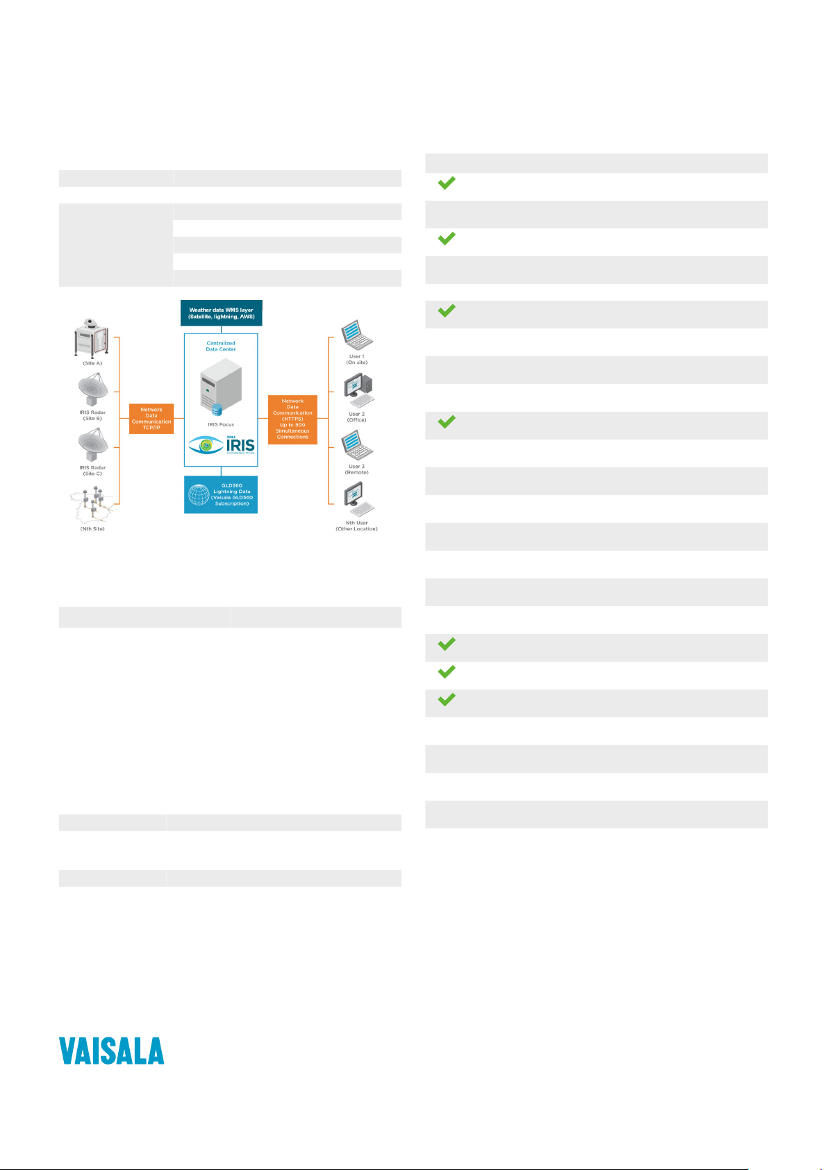
IRIS Focus in Remote Sensing Networks
Hardware requirements
Minimum
• Modern 4-core CPU (Intel Xeon E5
series or similar)
• 24 GB RAM
• 1 TB HDD
• 1400 x 1050 minimum screen
resolution
1) The pre-installed IRIS Focus system delivery option uses the Dell PowerEdge R440 rack server unit,
which meets the recommended hardware setup.
2) For a small installation with only a few users, 16 GB of RAM is sucient.
2)
Recommended
• Modern 8-core CPU (Intel Xeon E5
series or similar)
• 32 GB RAM
• 2x 1 SAS TB HDD in RAID 1
configuration
• 1920 x 1200 screen resolution
1)
Software requirements
Browser IRIS Focus supports current Microsoft Edgeâ, Mozilla
Operating system CentOS 7
IRIS Analysis IRIS 8.13.6 or later.
TLP TLP 1.2.7 (CentOS 8)
Firefoxâ, and Google Chrome™ browsers.
IRIS Analysis provides radar products through a
proprietary socket server connection.
Weather products
On-demand product Weather product
BASE
Echo Base
BEAM
Antenna Beam Pattern
CAPPI
Constant Altitude PPI
HMAX
Height of Maximum Intensity Product
LAYER
MAX
Maximum Data
MLHGT
Melting Level Height
MVF
Motion Vector Field
Network Health
Lightning network performance
PPI
Plan Position Indicator
RAIN1
Hourly Rain Accumulation
RAIN-N
N-Hour Rain Accumulation
RHI
Range Height Indicator
RTI
Range Time Indicator
SRI
Surface Rainfall Intensity
SHEAR
Wind Shear
SLINE
Shear Line (frontal boundary)
THICK
Echo Thickness
TimeSpan
Lighting event evolution
TOPS
Echo Tops Map
VAD
Velocity Azimuth Display
VIL
Vertically Integrated Liquid
VVP
Velocity Volume Processing
WARN
Warning/Centroid
WIND
Wind Speed and Direction
Published by Vaisala | B211811EN-B © Vaisala 2021
All rights reserved. Any logos and/or product names are trademarks of Vaisala or its individual partners.
Any reproduction, transfer, distribution or storage of information contained in this document is strictly
prohibited. All specifications — technical included — are subject to change without notice.
 Loading...