

Page 1
USB GPS User’s Guide (WIN)
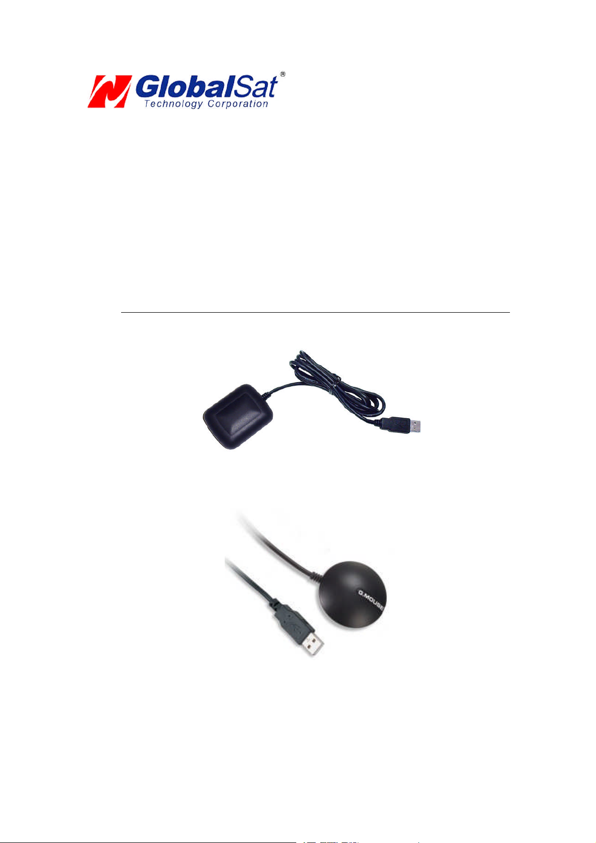
USBGPSReceiver
BU-303 (SiRF II)
BU-353 (SiRF III)
(Information oninstallationof theUSBdrivercontained inthis
documentisalsoapplicableto our USBcableset #BR305-USB)
Page 2

DOCUMENTREVISIONS
REVNO. DATE DESCRIPTION APPROVED
1.2 02-28-2003 Initial document BRF
2.0 06-08-2005 Newdocumentformat NRG
2.1 04-07-2006 Revisionofembedded webinks AAK
© 2006 Globalsat TechnologyCorporation/USGlobalsat, Inc.Allrights reserved. The Globalsat logois a trademark
of Globalsat Corporation. Windows is a register trademark of Microsoft Corporation. Acrobat is a registered
trademark of Adobe Systems Incorporated. Mac is a registered trademark of the Apple Corporation. All other
trademarks or registered trademarks are acknowledged as the exclusive property of their respective owners.
All rights reserved. No part of this manual may be reproduced, transmitted, copied, or stored in any storage
medium,foranypurpose,withoutpriorwrittenconsentfromGlobalsatTechnologyCorporationor USGlobalsat, Inc.
Globalsat/USGlobalsat hereby grants the right to download one (1) copy of this manual onto a hard drive for
personal use.This manualis copyrighted andmay containproprietary information thatis subject to changewithout
notice.
Page 3

USB GPS(WIN)
Table of Contents
PACKAGE CONTENTS..................................................................................................3
SYSTEM REQUIREMENTS...........................................................................................3
WELCOME......................................................................................................................3
1. GETTING STARTED..................................................................................................4
2. INSTALLINGTHE USB DRIVERTO YOUR LAPTOP..............................................4
3. COM PORT VERIFICATION......................................................................................5
4. INITIALIZING YOUR GPS RECEIVER......................................................................6
5. USING/ TESTING YOUR GPSRECEIVER..............................................................6
6. UN-INSTALLTHE USB DRIVER...............................................................................8
7. FAQ’s..........................................................................................................................8
8. CONTACT INFORMATION........................................................................................9
9. SAFETYAND LEGAL NOTICES...............................................................................9
10. LIMITED WARRANTY............................................................................................11
11. BU-303 SPECIFICATIONS....................................................................................12
12. BU-353 SPECIFICATIONS....................................................................................13
PAGE2 OF13
USB_GPS_WIN_v2.1
Page 4

USB GPS(WIN)
PACKAGE CONTENTS
- USB GPSReceiver
- Driver CD-ROM withUser’s Guideandtest utilityforWIN and MacO/S*
WIN Users please refer to the root directory on the included CD-ROM for installation instructions
anddrivers.
NOTE: Yourcanalso download WIN driver andInstallationGuidesat: www.usglobalsat.com/
SYSTEM REQUIREMENTS
The Globalsat USB GPS receivers requires a Windows, or Macintosh laptop computer, with a CDROM*, USB port, and NMEA compatible navigation software. The 3rdparty mapping/navigation
software may haveits ownsystemrequirements, please checkwithsoftwarevendorfor details.
*CD-ROMis required for USB driver installation and access to the User’s Guide. If no CD-ROM drive is available,
filescan bedownloadedfromtheInternetat: http://www.usglobalsat.com/
WELCOME
Thank you for purchasing a Globalsat USB GPS receiver! GlobalsatUSB GPS receivers allow for real-time street
navigationbyusingyourlaptopforgraphicalplotting and positioning of yourroute. Simply loadtheGPSdriver,plug
the GPS receiver into your computer’s USB port and install your own personal mapping software to begin to view
your position inreal-time inrelationto the surroundingstreets in yourtravelarea.
You’ll find that almost any NMEA compliant mapping/charting software will be compatible with your USB GPS
receiver.Visitourweb-site forrecommendedmappingprograms thatyou canuse.
http://www.usglobalsat.com/faq_details/Mapchart.asp
PAGE3 OF13
USB_GPS_WIN_v2.1
Page 5
USB GPS(WIN)
1. GETTING STARTED
Theseare onlya fewsimple steps thatyouneedto followbeforeusing your USB GPS receiver:
Install theUSB driverand onto your laptop from theincludedCD-ROM or download the files from our web-site
www.usglobalsat.com
Plug-in the GPS receiver into yourlaptop.
NOTE: From within your mapping, or navigation software (including the supplied GPS Information utility), you will
needto manually configure theselection of the COM port to what wasassignedto the GPS receiverso thatproper
communication between the GPS receiver and mapping program can occur. Most all software requires that you
manually configuretheCOMportsettingforanyGPSdevice youuse.
IMPORTANT:
1. Youmust change the default ratesetting of your mappingsoftware ‘s Baud Rate to 4800if thisis not currently
setas suchotherwise GPS datacannotbe received.
2. SetBaudRate 4800, Data Bit:8, Parity:None,Stop Bit:1, Flow Control:None
2. INSTALLING THE USB DRIVER TO YOUR LAPTOP
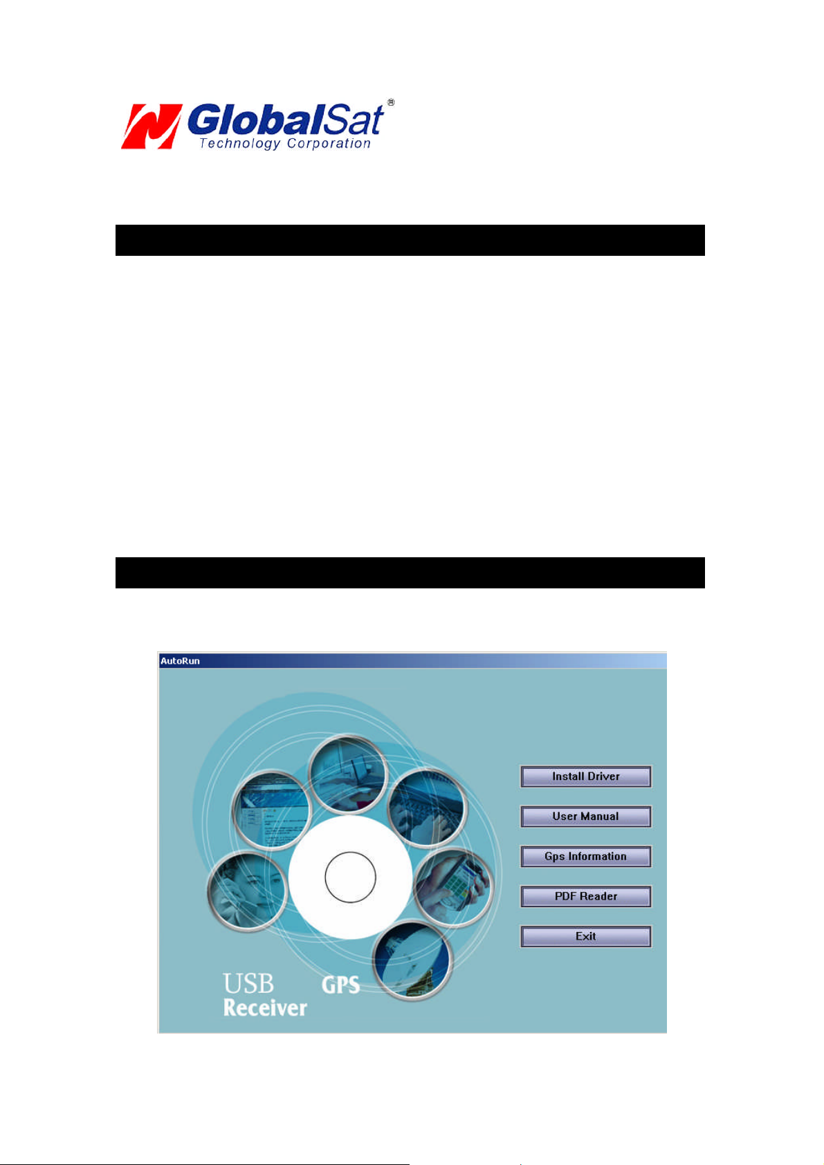
1. Place the product CD-ROMintoyourCD-ROMdrive.
2. Auto-run should detect the CD bring up thefollowing screenbelow.
PAGE4 OF13
USB_GPS_WIN_v2.1
Page 6

USB GPS(WIN)
3. Click on thebuttontitled “Install Driver” fromthe mainscreen as shownabove.
4. Or should your “Auto-Run” be disabled on your PC, use Windows Explorer or File Manager to
locate thefile titled ”PL-2303Driver Installer.exe” in the root directory of the CD-ROMand click to
launchthe install process.
3. COM PORT VERIFICATION
1. OnceyourUSB Driver hasbeen installed, youwillneed to confirm which COM PortyourPC
hasassignedto itin orderto properly configure any softwarethatwillbe utilizingthe GPS data
being received.
2. Your USB GPSMUSTbe pluggedinto yourUSB portat thistime.
3. UsingWindow’sControl Panel, select System > Hardware> Device Manager
4. Then lookunderthe heading of: PORTS(Com & LPT)
5. There should be a listingfor: Prolific Serial-to-USB Comm Port(COMx)
(“x” willactually bethe number yourPC has assignedthe USBGPS receiver).
6. Onceyouhave identifiedthe COM portnumber, anysoftwarethat youutilize mustbe
configuredto read GPSdatafromthisCOM port.
We strongly suggest thatyoufirsttest your USB GPS with the includedGPS Infoutilityprogramto
confirmthattheGPS receiver if functioningproperlyon your PC and thatyouhave successfully
configuredthe rightCOM Portsetting. Oncethishas beendone, closethe GPSInfo program and
start yourapplicationfor COM portconfiguration.
NOTE: By default,yourPC willnot allowyou to runmultiple applications froma singleCOM port. It
is important thatyou close anypreviously opened GPS applicationbefore switching to another
GPSapplicationas theGPS receiverand datawillnot befound bythe new program.
There arespecial utilities available to splitdatainto multiple COM portsfor useby morethan one
applicationsimultaneously. (see: http://franson.com/gpsgate/)
PAGE5 OF13
USB_GPS_WIN_v2.1
Page 7

USB GPS(WIN)
4. INITIALIZING YOUR GPS RECEIVER
Before using your USB GPS receiver for navigation (especially for the first time), the receiver must
obtain a localGPS fix(coordinates) of the current position. To do this,take yourlaptop(with your USB
driver and the mapping software loaded and configured) to an open area that has a clear view to the
sky (such as a park or emptyfield). Start your software (or the included GPS Info utility program) and
wait for initialization of the GPS to complete. This may take a few minutes depending on various
factors such as the distance of the current coordinates from the last time the GPS receiver was
activated, GPS signal strength and surrounding terrain (tall trees and buildings can block the satellite
signals). Once the RAW GPS data is displayed onto the screen, if applicable for your software, a fix
has been initialized (red LED on the GPS willalso start to flash). In some cases initialization can take
up to several minutes depending on the conditions mentionedabovebeforecomplete GPS datawill be
displayed on thescreen.
Coordinatesscrollingwithzero’s meansthatthe port connectionis complete,but the satellite datais not
being receivedyet (possibly still initializingor in a badareafor satellite reception).
5. USING / TESTING YOUR GPS RECEIVER
Once the USB GPS receiver’s driver and your personal mapping software have been installed and
configured properly, you can begin to use your navigation system by plugging the USB GPS into your
laptop’s USB port and launching your mapping software. If you don’t have a mapping, or navigation
software, we’ve included a GPS test utility called “GPS Info” for the purpose of confirming your
installation and configuration. This utility can be installed by clicking the GPSInfo.exe file fromthe Win
directory on theCD-ROMor downloaded fromour web-sitewww.usglobalsat.com.
LEDStatus indicatoron the USBGPS”
LEDOFF: GPSreceiver isoff (no power).
LEDON (solid): Nofix,searchingfor GPS signals.
LEDFLASHING: Positionfix establishedand GPS signalsarebeing received.
Always select an area in the vehicle where the GPS unit willbe secureand not obstruct normal driving,
visibilityand safety, butstillmaintaininga “view to thesky” in order to receivesatellitedata.
Itisrecommended thatyou first load and testyourGPS receiver with the GPSinfo.exe. Thisprocess
will confirm youhave found correct COMportnumber and haveconfiguredit properly.
1. RunGPSinfo.exe to loadthe utility.
2. EntertheproperCOM portfor yourGPS device (seeCOM PortVerificationabove)
3. SetCOM portto Baud rate: 4800
4. If no errors have been made in configuration, there should be GPS data being displayed in the
window, which is confirmation that the communication between the GPS device and the “GPSinfo”
software is working properly.
5. If thereis no GPSdata displayed(or datawith multiple zerosin them), pleaseexitthe software and
unplugthe GPS receiverfromthe USB portand reinsert it after 10 seconds toresetthe device.
PAGE6 OF13
USB_GPS_WIN_v2.1
Page 8

USB GPS(WIN)
Theabovescreen showsthe available satellites (numbers) andtheirsignal strength.
NOTE: Configuration (or selection) of an assigned COM port for the GPS device from within your
mappingor chartingsoftwaremust be completedwheneverusinga softwarefor the first time.
PAGE7 OF13
USB_GPS_WIN_v2.1
Page 9

USB GPS(WIN)
6. UN-INSTALL THE USB DRIVER
Runthe filethe Remover98_2k.exeto uninstallthe USBGPS driver.
7. FAQ’s
I an not getting GPS dataintomy application.
1. Check yourDEVICE MANAGER to confirm the COM Portnumber assignedto the GPS
Receiver (it will be listedunder the PORTS (COM& LPT) heading as Prolific Serial-to-USB
Comm. Then besure thisis the sameCOM portnumber configured inyour application.
2. Be sureyourBaudrate is configuredcorrectlyat:
Baud Rate:4800
Databit:8
Parity:None
StopBit:1
FlowControl:None
3. Re-bootyour computerandthen inserttheUSB GPS into a USB port.
4. Configure the GPSInfoutilitywiththe correct COM Portand testyourGPSreceiverfirst
before using it in your application.
Willthe USBGPS workwith other StreetMapping software?
Globalsat USB GPSreceiversprovidesstandard NMEA dataformapping software to use andconvert
to coordinatesand shouldworkwellwith mostany NMEAcompliant softwareon the market today.
How accurate is the GPS?
TheUSB GPS is WAAS/EGNOS capable,and for units sold in NorthAmericathrough authorized
resellers,theseunitsare WAAS/EGNOS enabled unlessotherwisestated. Accuracycan be up to 5
meters 3D RMSwithWAAS enabledand 10-15meters2D RMSWAAS disabled
What is idealGPS environment?
TheGPS requiresan open,clear viewof the sky. Buildings,coveredparking areas,tunnels and dense
foliage can causethe GPSreceiverto be unable to geta location fix.
Ifyouare parked in a covered parkinglot or neara tallbuilding,it is recommendedthat youdriveaway
until youhave a clearviewof the skybeforeusingthe BU-303. Youmay needto give theGPS a few
minutesto find orget a fix itslocation.
How do I know if theGPS is ON?
Your USB GPSmust be plugged intoyourlaptop’sUSB portto get power. If yourPC is on and the
COMport wasconfigured properly, the GPS receiver is on and receiving thestreaming GPS data. This
canbe verified byopening yourmapping software program. In addition,the GlobalsatUSB GPS has a
built-in LED status indicatorthat shows the following:
LEDOFF: GPSreceiver isoff (no power).
LEDON (solid): Nofix,searchingfor GPS signals.
LEDFLASHING: Positionfix establishedand GPS signalsarebeing received.
PAGE8 OF13
USB_GPS_WIN_v2.1
Page 10

USB GPS(WIN)
Whydoes the GPS not work nearbuildings and other tallobjects?
TheGPS usessatellites in the space to findout whereit is. Therefore it needs a clearviewof the sky.
Tall buildingsand other objects that blockthe receiver’sviewto thesky makeit infeasible to determine
your location. Sometimesthe satellitesare not overhead but nearthe horizon. In these cases theGPS
must have a clear viewof the horizon.
Other Comments-
Pleaseallowan adequate amount oftime forthe GPS receiver’s boot-up(TTF)to completebefore
contactingTechnical Support.
Driver updatescan be found at Prolific’s web-site:
http://www.prolific.com.tw/eng/downloads.asp?ID=31 (www.prolific.com.tw)
8. CONTACT INFORMATION
Globalsat TechnologyCorporation(Taiwan)
www.globalsat.com.tw
service@globalsat.com.tw (pre-sales GPSproduct questions only)
USGlobalsat, Inc.
www.usglobalsat.com
sales@globalsat.com (pre-sales GPS productquestions only)
Technical Support (NorthAmerica)
Seeour DOWNLOADS and FAQsection on our web-sitefor GPSsolutions, driver literature updates.
http://www.usglobalsat.com/custom.asp?recid=7
Pre-registration is requiredbefore receiving any typeof technicalsupport. Supportissues submittedvia
phone,faxor e-mail (anymeansoutside of therecognized“TroubleTicket” generated fromyour own
USGlobalsatregistered account) WILLNOT be answered.
Create your accountand registeryourproducts at: www.usglobalsat.com/support/custadminlogin.asp
9. SAFETY AND LEGAL NOTICES
Please read this section carefully before using the GPS receiver
Globalsat Technology Corporation / USGlobalsat, Inc. will not accept any responsibility
whatsoever for accidents resulting from failure to observe common sense precautions. Your
personal judgment, traffic regulations, and common sense must always take precedence over
anydirections produced by GPS receiveror the mapping software
WARNING: Make sure that the GPS receiver is secure and does not interfere with driving
visibilityand safety.
It is your responsibility as the vehicleoperator to securely placethe GPSunit and antenna so thatthey
will not interfere with driving and prevent operations of any safety device (such as the Airbag) in your
vehicle. Donot mount the devices in a place wherethe driver or passengers may receive injury during
vehicle operation or collision. For your safety, take careto route all cables away from shifters, pedals,
accessory controlsand mechanisms.
PAGE9 OF13
USB_GPS_WIN_v2.1
Page 11

USB GPS(WIN)
WARNING:Drive safelyand use common sense.
It is your responsibility as the vehicleoperator to drive safely, observe all traffic rules and above all use
your own personaljudgment while driving. If youfeel thata route suggestedby the navigation software
instructs you to performan unsafe or illegal maneuver, places you in an unsafe situation, or routes you
intoan areawhichyouconsider unsafe, do notfollow the instructions.
WARNING:Keep your eyes on theroad.
Itisyour responsibilityas the vehicle operatorto keep youreyeson the roadand be an alert driver at all
times, especially when the vehicle is moving. The vehicle’s operator should not be distracted by the
navigation equipment or software. Should there be a distraction with the ability to drive responsibly,
please turn off the device. Should you want to look at the display for a prolonged time, park the car
safely,whilefollowing all trafficregulations before lookingat the display.
WARNING: To reduce the risk of fire or shock hazard, do not expose this product to rain or
moisture. Do not remove covers or open housings, there are no user serviceable parts inside.
Refer servicing to qualifiedpersonnel only.
PAGE10 OF13
USB_GPS_WIN_v2.1
Page 12

USB GPS(WIN)
10. LIMITED WARRANTY
Globalsat/USGlobalsat warrants product hardware against manufacturing defects in material and workmanship
under normal use for a period of one (1) year from the original date of purchase (unless the product states
otherwise), and only when purchased from a recognized “authorized dealer”. Products purchased from any
unauthorized source, such as unauthorized e-Bay resellers, will not qualify for free warranty service/support and
may require the end-user to pre-pay fees associated with, but not limited to the support, repair, replacement and
shipping oftheproduct to andfromtheservicecenter.
Except as provided herein, Globalsat/USGlobalsat makes no express warranties’, including but not limited to any
warranties of merchantability or fitness for particular use, or non-infringement. You acknowledge that your use of
the product or service is at your sole risk and you agree that the information provided are without warrantyof any
kindby Globalsat/USGlobalsat.
Under no circumstances, including negligence, will Globalsat/USGlobalsat or any of its affiliates, directors, officers
or employees, or any third party be liable for any direct, indirect,incidental, special or consequential damages that
resultsfrom youruse, or your inabilityto use, or the performanceof the product(s) with respect to anyliability, loss,
orarising out ofanybreach of thiswarranty, including,butnotlimited to anydamagesresultingfrominconvenience,
loss of time, data, property, revenue, or profit or any indirect, special incidental or consequential damages. You
acknowledge that this limitation applies to all content information or other services available from
Globalsat/USGlobalsat, and whether or not Globalsat/USGlobalsat has notice of the possibility of such damages,
and whether or not to circumstances giving rise to such damages may have been within the control of
Globalsat/USGlobalsat.
Some states do not allow the exclusion of certain warranties, so some of the above exclusions may not apply to
you. In those states, liability is limited to the fullest extent allowed by law By using the product(s), you agree to
indemnify Globalsat/USGlobalsat and its parents, subsidiaries, affiliates, officers and employees and hold them
harmless from any and allclaims and expenses,includingreasonable attorney’s fees, asserted thirdparty due to, or
arisingoutof youruseof theserviceandthesite.
In the eventof a productdefect during thefirst30-days of the warranty period, returnproduct and the sales receipt
asproofof purchase date to placeof originalpurchase.Defect discovered after 30-days fromdateof purchase, you
must contactGlobalsat/USGlobalsat’sTechnical supportfora Return Merchandise Authorization (RMA)number for
returnto manufacturer.
Globalsat/USGlobalsat will, at itsoption,unless otherwiseprovided bylaw:
a.) Correct the defectbyproduct repair without chargefor parts and labor;
b.) Replace the product with one of thesameorsimilardesign;or
Refund the purchaseprice. All replaced parts and products, andproductson whicha refundis made,become the
property of Globalsat/USGlobalsat. New or reconditioned parts may be used in the performance of warranty
service. Repaired or replaced parts and products are warranted for the remainder of the original warranty period.
Youwillbe chargedforrepair or replacementof the product made aftertheexpirationof thewarrantyperiod.
This warrantydoes not cover:
a.) Damage or failure caused by or attributable to acts of God, abuse, accident, misuse, improper or
abnormal usage, failure to followthe instructions, improperinstallationor maintenance, alteration,lighting
orotherincidenceof excessvoltage or current;
b.) Anyrepairs otherthanthose providedby Globalsat/USGlobalsat;
c.) Consumablessuchas fuses orbatteries;
d.) Cosmetic damage;
e.) Transportation, shippingorinsurance costs;
f.) Costs of productremoval,installation,set-up serviceadjustment or reinstallation.
This warranty gives you specific legal rights, and you may also have other rights, which may vary from state to
state.
Additional products bundled in this package not manufactured by Globalsat/USGlobalsat will hold separate
warranties as expressed by the individual manufacturer of that product(s). Product specifications, functions and
features are subject to changewithoutnotice.
PAGE11OF 13
USB_GPS_WIN_v2.1
Page 13

USB GPS(WIN)
11. BU-303 SPECIFICATIONS
ElectricalCharacteristics (Receiver)
GPSChipset SiRF Star II e/LP
Frequency L1,1575.42MHZ
C/ACode 1.023MHz chip rate
Channels 12 all-in-view tracking
Sensitivity -147dBm
Accuracy
Position Horizontal
Velocity 0.1m/sec 95% (SAoff),
WAAS Enabledfor North Americaproducts (USGlobalSat, Inc)
Datum
Datum WGS-84
Acquisition Rate
Hotstart 8 sec., average (withephemerisandalmanac valid)
Warm start 38sec.,average (withalmanacbut not ephemeris)
Cold start 45 sec.,average (neitheralmanac norephemeris)
Reacquisition 0.1sec.average (interruption recoverytime)
Protocol
GPSProtocol Default: NMEA0183 (Secondary:SiRF binary)
GPSOutputData
GPStransfer rate Software commandsetting (Default: 4800,n,8,1forNMEA)
Dynamic Condition
Acceleration Limit Less than4g
Altitude Limit 18,000meters(60,000 feet)max.
Velocity Limit 515 meters/sec. (1,000knots) max.
Jerk Limit 20 m/sec**3
Temperature
Operating -40°~176°F(-40°~80°C)
Storage -40°~176°F(-40°~80°C)
Humidity Upto 95%non-condensing
Power
Voltage 5V ±5%
Current 90mA typical
Physical Characteristics
Dimension 2.32"x 1.65" x 0.82"(59mm x 47mm x 21mm)
USBCable Length 60"(152cm)
Low Noise Amp
Amplifier Gainw/out cable 27 dB Typical
Filtering -25dB(+100MHz)
OutputVSWR 2.0Max.
Voltage DC3 ~ 5.0V
Current 15mA max@ 5VDC
Dueto continuousproductimprovements, all specificationsaresubjectto change withoutnotice.
10m2D RMSWAASenabled
15m2D RMSWAASdisabled
SiRF binary>>position,velocity,altitude, statusand control
NMEA0183MEA0183V2.2protocol, and supports
command: GGA,GSA,GSV,RMC,VTG, GLL v2.2 (VTG
andGLLareoptional)
FCCNOTICE
Thisdevicecomplieswithpart15 of theFCCrules.Operationissubject tothe followingtwoconditions:
(1)Thisdevice maynotcause harmfulinterference, and(2) Thisdevice must accept anyinterferencereceived, includinginterferencethatmaycause
undesiredoperation.FCCRF Exposurerequirements: Thisdeviceanditsantenna(s)mustnotbe co-located or operationin conjunction withanyother
antennaor transmitter. NOTE: THEMANUFACTURERISNOT RESPONSIBLEFOR ANYRADIOOR TVINTERFERENCECAUSEDBY
UNAUTHORIZEDMODIFICATIONSTO THISEQUIPMENT.SUCHMODIFICATIONS COULDVOIDTHEUSER'SAUTHORITYTO OPERATE
THEEQUIPMENT.
PAGE12OF 13
USB_GPS_WIN_v2.1
Page 14

USB GPS(WIN)
12. BU-353 SPECIFICATIONS
ElectricalCharacteristics (Receiver)
GPSChipset SiRF Star III e/LP
Frequency L1,1575.42MHZ
C/ACode 1.023MHz chip rate
Channels 20 all-in-view tracking
Sensitivity -159dBm
Accuracy
Position Horizontal
Velocity 0.1m/sec 95% (SAoff)
WAAS/EGNOS Enabledfor North Americaproducts (USGlobalSat,Inc)
Datum
Datum WGS-84
Acquisition Rate
Hotstart 1 sec., average(withephemerisandalmanacvalid)
Warm start 38sec.,average (withalmanacbut not ephemeris)
Cold start 42 sec.,average (neither almanacnor ephemeris)
Reacquisition 0.1sec.average (interruption recoverytime)
Protocol
GPSProtocol Default: NMEA0183 (Secondary:SiRF binary)
GPSOutputData
GPStransfer rate Software commandsetting (Default: 4800,n,8,1forNMEA)
Dynamic Condition
Acceleration Limit Less than4g
Altitude Limit 18,000meters(60,000 feet)max.
Velocity Limit 515 meters/sec. (1,000knots) max.
Jerk Limit 20 m/sec**3
Temperature
Operating -40°~185°F (-40°~85°C)
Storage -40°~185°F (-40°~85°C)
Humidity Upto 95%non-condensing
Power
Voltage 4.5~ 5.5V DCInput
Current 80mA typical
Physical Characteristics
Dimension 2.08"diameterx 0.75"(53mm dia.x 19.2mm)
USBCable Length 60"(152cm)
Low Noise Amp
Amplifier Gainw/out cable 27 dB Typical
Filtering -25dB(+100MHz)
OutputVSWR 2.0Max.
Voltage DC3 ~ 5.0V
Current 15mA max@ 5VDC
Dueto continuous product improvements, allspecifications are subject to change withoutnotice.
5m2D RMS WAASenabled
10m2D RMSWAASdisabled
SiRF binary>>position,velocity,altitude, statusand control
NMEA0183MEA0183V2.2protocol, and supports
command: GGA,GSA,GSV,RMC,VTG, GLL v2.2 (VTG
andGLLareoptional)
FCCNOTICE
Thisdevicecomplieswithpart15 of theFCCrules.Operationissubject tothe followingtwoconditions:
(1)Thisdevice maynotcause harmfulinterference, and(2) Thisdevicemustacceptany interferencereceived, including interferencethatmaycause
undesiredoperation.FCCRF Exposurerequirements: Thisdeviceandits antenna(s)must notbe co-locatedoroperationin conjunctionwithany other
PAGE13OF 13
USB_GPS_WIN_v2.1
Page 15

USB GPS(WIN)
antennaor transmitter. NOTE: THEMANUFACTURERISNOT RESPONSIBLE FOR ANYRADIOOR TV INTERFERENCECAUSED BY
UNAUTHORIZEDMODIFICATIONSTO THISEQUIPMENT.SUCHMODIFICATIONS COULDVOIDTHEUSER'SAUTHORITYTOOPERATE
THEEQUIPMENT.
PAGE14OF 13
USB_GPS_WIN_v2.1
 Loading...