

Page 1

Connect R1 to Tablet, GNSS Status, and Collector App
Connect the Trimble R1 to your tablet:
Read the Quick Start Guide, Step 1, 2 and 3. Turn on the R1 then press and hold 5 seconds – the LED should flash Blue –
Blue – Blue – Blue continuously. Only then it is in pairing mode and discoverable by your tablet. (See image below from
Trimble’s Quick Start Guide Trimble R1 GNSS Receiver).
Quick Start Guide Trimble R1 GNSS Receiver– Read it.
S:\Hydraulics\TAMS HydInfra\Manuals and Helpsheets\Collector and GPS Guides\Collector Pairing R1 GPS and Tablet.docx
May 3, 2019 1
Page 2

Pair the Trimble R1 GNSS receiver and the tablet
(R1 LED is flashing Blue – Blue – Blue – Blue continuously.)
Click the Start button on the tablet.
Choose Settings.
Go to Settings > Devices > Bluetooth and other devices > Add Bluetooth or Other Device > Add
(Bluetooth slider is in On position. If you don’t see the slider, the tablet doesn’t have Bluetooth and you need a USB
plugin for your tablet).
Wait several seconds for the tablet to find the R1 and list it as GNSS####. (If your R1 is flashing blue continuously the
tablet should find it.)
Choose your GNSS##### from the “Add a device” list.
With successful Pairing you will see “GNSS:##### Paired”
Tablet Settings window looks like this:
+ Bluetooth Device.
S:\Hydraulics\TAMS HydInfra\Manuals and Helpsheets\Collector and GPS Guides\Collector Pairing R1 GPS and Tablet.docx
May 3, 2019 2
Page 3
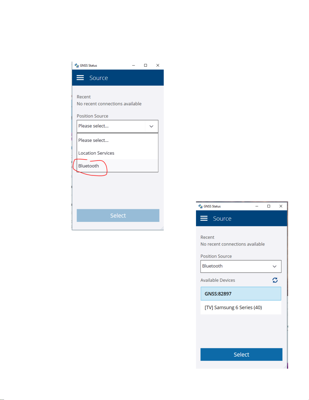
Connect the GNSS Status app with R1
(If you don’t have the app GNSS Status ask Service Desk to add it.)
Open GNSS Status on your tablet. Choose Source: Bluetooth
Select the R1 GNSS##### from Available Devices to use for the Bluetooth
connection.
S:\Hydraulics\TAMS HydInfra\Manuals and Helpsheets\Collector and GPS Guides\Collector Pairing R1 GPS and Tablet.docx
May 3, 2019 3
Page 4

GNSS Status to send NMEA data strings to ARCGIS Collector
NMEA data strings define the data sent from the GPS device to the Collector
app. Only 3 NMEA strings are required by Collector, but if you don’t
remember which three, send them all!
Left side shows Available NMEA data types and right side shows strings that
are Selected and will be transmitted. Send NMEA strings GGA, GGK and GSA
to the Selected side and click Apply.
When you first connect the Windows operating System drivers were installed
and associated the Bluetooth Serial Ports Profile (SPP) ports with Windows
COM ports for communication. Your Bluetooth port and Windows COM port
communication ties may vary.
Choose SPP1 and Save.
S:\Hydraulics\TAMS HydInfra\Manuals and Helpsheets\Collector and GPS Guides\Collector Pairing R1 GPS and Tablet.docx
May 3, 2019 4
Page 5

Before pairing the R1, location accuracy reflects the cellular data location accuracy (bad). But after pairing and with
SBAS real time correction, estimated accuracy should be less than one meter (or 3 feet in English units).
SBAS for Real Time Correction of Locations
Set Correction to SBAS for real-time correction of TAMS-HydInfra asset locations. SBAS is available without an internet
connection and it is free. The corrected location accuracy is generally less than 1 meter when using the Trimble R1.
If better accuracy is needed, use MnCORS
MnCORS username and password. Get a login at MnCORS registration, data access and user management website
http://mncors.dot.state.mn.us/Default.aspx
and a Trimble R2. To use MnCORS you will need an internet connection and a
S:\Hydraulics\TAMS HydInfra\Manuals and Helpsheets\Collector and GPS Guides\Collector Pairing R1 GPS and Tablet.docx
May 3, 2019 5
Page 6

Connect R1 to ARCGIS Collector
In Collector app, click the home menu (three horizontal lines at
upper left corner).
Choose the Settings icon > Location.
Location accuracy prevents GPS location capture if the estimated
accuracy is less than the threshold. For work without the R1 you
can adjust the Location accuracy threshold higher so you can use
the cellular GPS “find me” button. Remember to set XY Source to
match your location accuracy when capturing locations.
Choose Integrated Receiver
Look under Other for your R1 (GNSS#####) click on it, then click
Switch to make it the Current GPS receiver.
If your receiver
wasn’t listed under
Other click
receiver.
Select your GPS
receiver from the
list by clicking on it
and then click the
Switch button to
make it Current.
+Add a
S:\Hydraulics\TAMS HydInfra\Manuals and Helpsheets\Collector and GPS Guides\Collector Pairing R1 GPS and Tablet.docx
May 3, 2019 6
Page 7

We don’t use R1 Elevations
For R1 collection, set antenna height
generally at the level it will be held.
(Units are shown in previous window
with required location accuracy). It
makes no difference because we don’t
capture elevations.
For accurate elevations use an R2 and a
VRS (MNCORS) correction. A survey
rod with bullseye level and mount for
R2 is also required for good elevations.
If you use and R2 and have accurate
elevations, you must still type in the
elevation and choose the elevation
source “GPS < 1 ft” or “Survey”.
Finally
In the ARCGIS Collector app Settings > Location
window, your R1 should be the Current GPS
receiver.
The Collector Map window will show the location
accuracy in the lower right corner of the screen.
The location accuracy should be less than 3 feet (or
1 meter) nearly always. If location accuracy is 20
feet, your R1 is not connected in the Collector app.
S:\Hydraulics\TAMS HydInfra\Manuals and Helpsheets\Collector and GPS Guides\Collector Pairing R1 GPS and Tablet.docx
May 3, 2019 7
Page 8

Trouble-shoot R1 connection when Collector does not see the R1 corrected location
Collector and R1 connection problems have been frequent and widespread. The causes are still unknown.
• Steps to fix an R1 connection in Collector -- Ruth
1. In Collector, switch the receiver back to Location Services, and close Collector.
2. In GNSS Status, switch the receiver back to Location Services, and close GNSS Status.
3. In tablet, Bluetooth devices, select any R1 receivers listed there and Remove them.
4. In tablet Bluetooth devices, now re-add the R1 receiver, and after it is paired, wait a minute or two for the
driver to reinstall. You may not see any indication that it’s happening, so just wait about a minute.
5. Open GNSS Status, go into Source, and do not pick the R1 from recent devices, but rather tap the dropdown,
tap on Bluetooth, and select the R1 when it shows up in the available devices.
6. Go to NMEA (GNSS Status), make sure all NMEA strings (GGA, GGK, GSA) are on the right, Selected side and
tap Apply. Choose port 1.
7. Leave GNSS Status open, and just minimize the app.
8. Go to Collector, and set the location provider to your R1. Now open a map and wait a minute or so to see if
the position will come in.
• Possible interference from other Bluetooth devices, like phones – “when I had my cellphone on me, with its
Bluetooth on, the receiver’s connection to GNSS would drop every few minutes. I turned off the Bluetooth on
my phone and the receiver stayed connected. Just something to explore a little more.” -- Kellie
• Once the R1 was connected - it disconnected several times and shut off once – Kellie
• Frontier Precision – Dan – said try not connecting to GNSS Status. Trimble says bypassing GNSS Status is used to
fix Survey123 and R1 connection, though hasn’t been used with Collector.
• The R1 would vary from 50 centimeter to 15 meter accuracy – Kellie. (This means that even if the R1 is
connected, it might not always transmit a corrected location to Collector.)
Pay attention to the R1 LED indicators AND the Location Accuracy readout in the Collector app:
• Solid green means a solid connection to Collector and the location accuracy in Collector should be better than 1
meter.
• Flashing Yellow - Yellow has no GPS like inside a building
• Beware – the Collector app might hold onto a bogus number for accuracy after the R1 loses its location. Brought
inside the building, the R1 flashes Yellow – Yellow but the location accuracy shown in Collector app remained at
1.6 feet for more than 15 minutes without any R1 location and even after the screen timed out.
• Flashing Blue - Yellow the R1 is probably acquiring satellites
• Flashing Blue - Green the R1 has good location but is not talking to the Collector app. If screen times out, the R1
connection might be lost. To fix, close collector and re-open it. (That worked for me 1 of 1 attempts).
• Flashing Blue – Blue - Blue –Blue continuously is required to pair the R1 with the tablet initially.
1. More information is available in Quick Start Guide Trimble R1 GNSS Receiver and Helpsheet on GNSS
S:\Hydraulics\TAMS HydInfra\Manuals and Helpsheets\Collector and GPS Guides\Collector Pairing R1 GPS and Tablet.docx
May 3, 2019 8
Status Utility by Fro ntier Precision
 Loading...