

Инструкции по
безопасности
RU
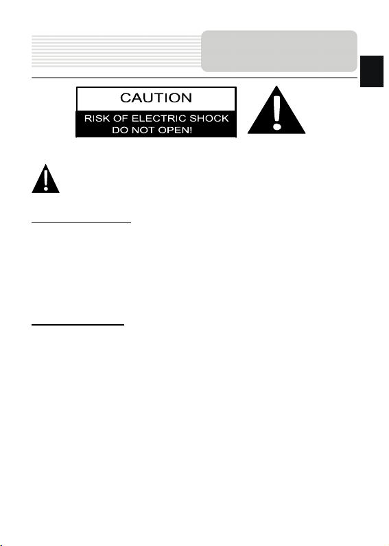
Значок восклицательного знака, вписанный в равносторонний
треугольник, обращает внимание пользователя на важный пункт,
изложенный в руководстве пользователя.
ПРЕДОСТЕРЕЖЕНИЕ
1. Чтобы устранить риск поражения электрическим током, не открывайте корпус
устройст ва. Внутри корпуса нет частей или деталей, ремонт которых может
быть выполнен самостоятельно. Предоставьте всю работу по устранению
неисправностей квалифицированному техническому персоналу.
2. Производитель не несет ответственность за повреждения, вызванные
несанкционированными изменениями в конструкции данного устро йства
.
ПРЕДУПРЕЖДЕНИЕ
Не размещайте емкости с водой или другой жидкос тью, а также мелкие предметы
на верхней поверхности устрой ства.
Для избежания повреждений устройства не подвергайте его дейс твию тепла
или прямых солнечных лучей. Уст ро йс тво должно работать в хорошо
проветриваемом помещении для избежания перегрева.
RU-1
RU
Аксессуары
Список аксессуаров
Изображение Описание Кол-во
(для GV5700/5700BT)
Автомобильное
зарядное устройство
Чехол
1
1
USB-кабель 1
Электронное перо 1
CD с драйвером и
документацией
1
Руководство
пользователя
1
Гарантийный талон
1
Крепление Smart Mount
Инструкция
(для крепления smart
mount)
RU-2
1
1
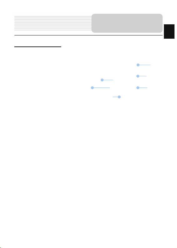
Вид спереди и сбоку
Обзор устройства
RU
5
1. Сенсорный ЖК-экран
Для выбора команд в меню или ввода информации нажмите по нему пальцем
или электронным пером.
2. Светочувствительный датчик
3. Разъем для наушников
Используется для подключения наушников. При подключении разъема
наушников звук из динамика будет выключен автоматич ески.
4. Слот для карт памяти стандарта microSD
Используется для устан овки карт памяти
фотографии или видео пользователя.
5. Кнопка перезапуска
Нажмите для перезапуска устройства.
6. Динамик
Используется для воспроизведения звука, гол оса или музыки.
2
1
6
microSD, содержащих музыку,
RU-3
3
4

Обзор устройства
RU
Вид сверху и снизу
2
1. Кнопка питания (Power)
Используется для включения и отключения устройства.
2. Мини-USB порт
Используется для подключения USB кабеля для получения данных или
зарядки батареи.
RU-4
1
Системные
подключения
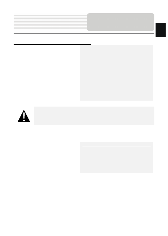
Установка карт памяти microSD
Внимание:
Перед извлечением microSD карты убедитесь, что она в данный
момент не работает ни с одним пр иложением.
Подключение к внешнему USB-устройству (Зарядка)
z Уст ан ав ли ва я microSD карту,
поверните ее коннектором к
устройству (этикетка должна быть
повернута к передней панели
устройства).
z Чтобы извлечь microSD карту, слегка
нажмите на край карты, чтобы снять
защитную защелку, и вытяните карту
из слота.
z Подключите mini USB-разъем к
соответствующем у mini USB-порту.
z Подключите другой USB-разъем к
USB-порту на ПК для зарядки.
RU
RU-5
Системные
RU
подключения
Подключение наушников
z Подключите разъем наушников (не
входят в комплект) к порту для
наушников, чтобы направить
подачу аудиосигнала с колонок на
гарнитуру.
Внимание:
Громкий звук потенциально вреден для слуха. Перед подключением
наушников рекомендуется снизить громкость и постепенно
повышать ее до комфортного уровня.
Использование автомобильного зарядного устройства
Внимание:
Рекомендуется подключать автомобильное зарядное устрой ство к
прикуривателю (12В) после зажигания двигателя, чтобы защитить
устройство от резких изменений напряжения.
z Подключите USB-коннектор к
соответствующем у USB-порту.
z Подключите коннектор автомобильного
зарядного устройства к прикуривателю
(12В).
RU-6

Питание
устройства
Использование батареи
Ваше портативное GPS-устройство имеет встроенную перезаряжаемую
аккумуляторную батарею. При первом использовании устройс тва необходимо
полностью зарядить батарею (как минимум 8 часов). Индикатор заряда батареи
горит красным цветом во время зарядки и зеленым после ее окончания. Время
зарядки составляет примерно 2 часа.
Обратите внимание при работе с батареей:
z Новая батарея должна быть полностью заряжена при первом
использовании.
z Работа и зарядка бата реи должны произходить при температуре от 0° до
37°C.
z Нет необходимости заряжать устройство до полной разрядки батареи.
RU
RU-7
RU
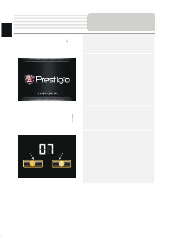
Начало работы
1. Что бы включить устро йство ,
нажмите и удерживайте кнопку
питания (Power).
2. Вскоре после приветствия на
экране появится главно е меню.
3. Дл я выбора функций
воспользуйтесь электронным
пером.
Sleep OFF
4. Нажмите и уд ерж ивай те кнопку
питания (Power), чтобы выключить
устройство или перевести его в
спящий режим.
5. Нажмите Sleep (Спящий режим),
чтобы перевести устро йство в
спящий режим, или OFF (Выкл.),
чтобы полностью выключить
устройство.
RU-8
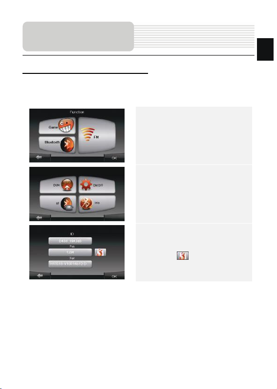
Функция Bluetooth
Главное меню
Функция Bluetooth (опционально)
В этом разделе содержится информация о включении, выключении и работе с
функцией Bluetooth.
1. Нажмите на пиктограмму Функция
в главном меню.
2. Нажмите на пиктограмму
Bluetooth, чтобы начать
использование функции Bluetooth.
3. Нажмите на пиктограмму
ВКЛ/ВЫКЛ, чтобы включить или
выключить функцию Bluetooth.
4. Нажмите на пиктограмму Инфо,
чтобы ознакомиться с
Bluetooth-информацией.
5. Нажмите , чтобы устано вить
новый PIN-код. PIN-код по
умолчанию - 1234.
RU-9
RU
RU
Работа с функ цией Bluetooth.
Соединение Bluetooth
1. Нажмите пиктограмму DUN или HF
в главном меню.
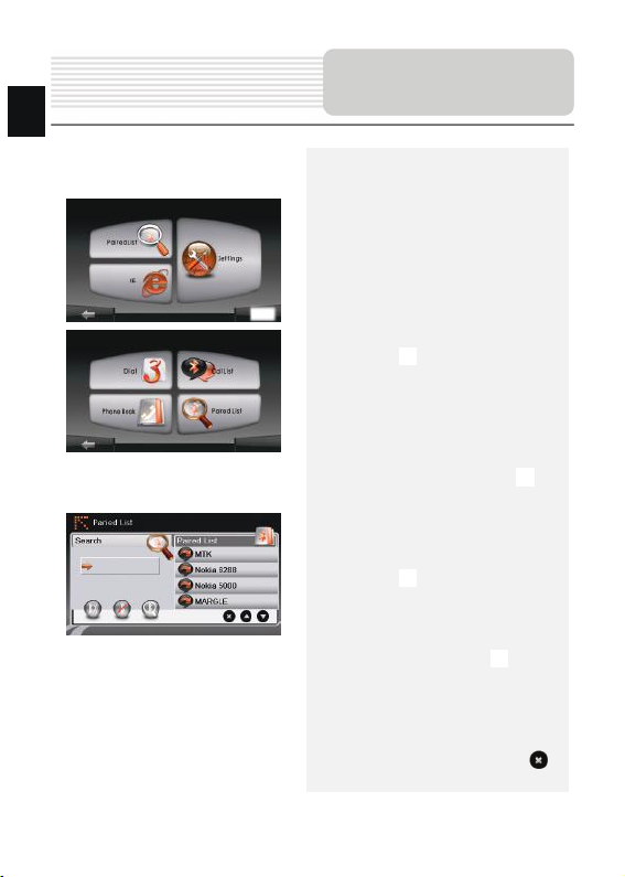
2. Нажмите Сопряженные
устро йства, чтобы начать
сопряжение с мобильным
телефоном (при наличии у
последнего функции GPRS).
3. Убедитес ь, что мобильный
телефон доступен для соединения
с другими Bluetooth-устрой ствам и.
4. Нажмите , чтобы начать поиск.
5. Название мобильного теле фона,
доступного для соединения, будет
отображ ено в списке по
завершению поиска.
6. Нажмите на названии мобильного
телефона, а затем нажмите ,
чтобы установить соединение.
7. Введите PIN-код 1234 при
требовании мобильного телефона
ввести номер PIN.
8. Нажмите , чтобы прервать
текущее Bluetooth-соединение.
9. Выберите название мобильного
телефона в списке Сопряженные
устро йства, и нажмите , чтобы
вновь устано вить соединение с уже
сопряженным мобильным
телефоном.
10. Вы берите название мобильного
телефона в списке и нажмите ,
чтобы удал ить его из списка.
RU-10
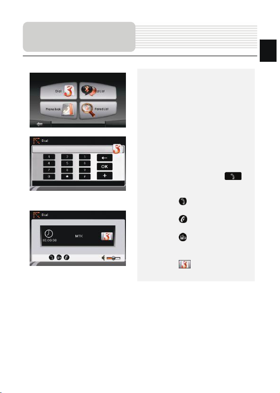
Функция Hands Free
1. Нажмите на пиктограмму HF
(HandsFree) в главном меню.
Внимание:
Ознакомьтесь с разделом Соединение
Bluetooth, прежде, чем использовать
функцию Hands Free.
2. Нажмите на пиктограмму Набор
номера, чтобы совершить звонок.
3. Воспользуйтесь виртуальной
цифровой клавиатурой для набора
номера, а затем нажмите ,
чтобы начать звонок.
4. Нажмите , чтобы ответить на
звонок, если он удер живает ся.
5. Нажмите , чтобы завершить
звонок.
6. Нажмите , чтобы перевести
звонок на мобильный теле фон или
обратно на устройство.
7. Нажмите для вывода
цифровой клавиатуры.
RU
RU-11
RU
Hands Free Function
8. Нажмите на пиктограмму
Адресная книга, чтобы
просмотреть контакты.
9. Нажмите , чтобы просмотреть
контакты адресной книги,
хранящиеся на SIM-карте.
10. Нажмите / , чтобы прокрутить
страницы вверх/вниз.
11. Вы берите контакт в адресной книге
и нажмите для совершения
звонка.
12. Вы берите контакт в адресной книге
и нажмите , чтобы удал ит ь его.
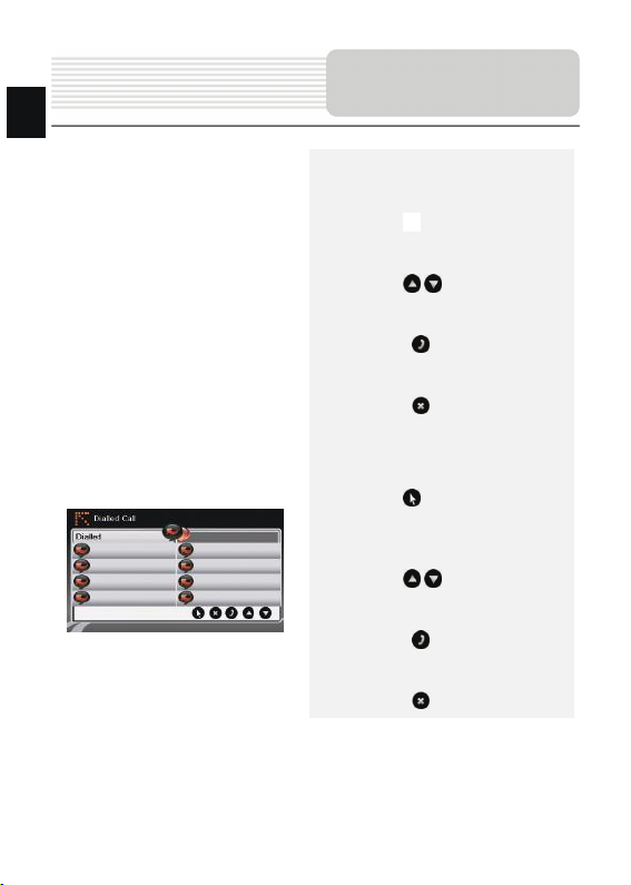
13. Нажмите на пиктограмму Звонки,
чтобы просмотреть историю
звонков.
14. Нажмите , чтобы просмотреть
список Набранных звонков,
список Принятых звонков, и
список Пропущенных звонков.
15. Нажмите / , чтобы прокрутить
страницы вверх/вниз.
16. Вы берите контакт в адресной книге
и нажмите для совершения
звонка.
17. Вы берите контакт в адресной книге
и нажмите , чтобы удал ит ь его.
RU-12
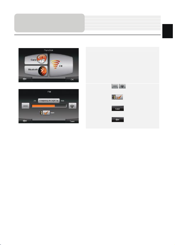
Функция FM
(
опционально)
1. Нажмите на пиктограмму Функция
в главном меню.
2. Нажмите на пиктограмму FM,
чтобы начать использовать
функцию Bluetooth.
3. Нажмите / , чтобы снизить
или увеличить FM-частоту.
4. Нажмите , чтобы
отрегулировать звук.
5. Нажмите , чтобы сохранить
текущую FM-станцию.
6. Нажмите , чтобы отменить
настройки и покинуть меню.
RU
RU-13

RU
No. Название Краткое описание функций
Знак предстоящего маневра. На сером фоне – различные
Следующий
1
маневр
2 Компас
3 Звук
Информаци-
4
онная панель
5 GPS-курсор
6 Маршрут
повороты, развороты, расстояние до следующего маневра
в метрах или километрах и т.д. Нажатие по знаку –
прекращение ведения по маршруту и другие опции
маршрута.
Нажатие на иконке компаса открывает контекстное меню. В
этом меню Вы можете настроить режим вращения карты,
вид карты и дневной/ночной режимы карты.
Нажатие на эту кнопку включает и отключает звуковые
эффекты и голос овые подсказки в программе .
Содержит информацию о времени до следующего маневра,
общей длине маршрута и времени прибытия в конечную
точку.
Отображает Ваше текущее местоположение при установ-
ленной связи со спутниками.
Маршрут, по которому осуществляется навигация, обозна-
чается широкой линией желтого цвета.
RU-14
Интерфейс
программы
Интерфейс
рогр
п
аммы
No. Название Краткое описание функций
Нажмите на данную кнопку для перехода к меню поиска
7 Поиск
Информаци-
8
онная панель
9 Масштаб Текущий масштаб карты.
Возврат в те-
10
кущее место-
положение
Автомати-
ческое
11
масштабиро-
вание
12 МЕНЮ Нажмите для входа в главное меню программы.
13 Уменьшить Уменьшение масштаба карты.
14 Увеличить Увеличение масштаба карты.
15 Наклон карты
16 Радар
нужного адреса или объекта (более подробная
информация о системе поиска указана в разделе
“Функциональные возможности”)
Отображает название проезжей части, по которой в данный
момент осуществляется движение
Данная кнопка появляется в правой части дисплея в том
случае, если карта была сдвинута относительно Вашего те-
кущего местоположения. Нажмите на кнопку, чтобы совмес-
тить центр карты с Вашим текущим местоположением.
Если в настройках автоматическое масштабирование было
включено, но во время движения по маршруту Вы с
помощью кнопок «Плюс» и «Минус» поменяли масштаб, то
автоматическое масштабирование выключается на
заданный в настройках период времени. Быстро включить
его обратно можно при помощи этой кнопки.
Стрелка вверх увеличивает наклон карты, в своем
максимальном положении наклона карта переходит в вид
псевдо 3D, работающий на масштабах от 5м до 300м.
Стрелка вниз уменьшает наклон карты.
Если в настройках визуальное предупреждение было вклю-
чено, то при приближении к радару на дороге в правом
верхнем углу появляется панель. На ней указана
максимально допустимая скорость движения и расстояние,
оставшееся до радара. Нажатие на кнопке включает/
выключает звуковые предупреждения о превышении
скорости.
RU-15
RU

рогр
RU
п
аммы
No. Название Краткое описание функций
17 Скорость
Информаци-
18
онная панель
19 Батарея
Соединение
20
спутниками
Текущая скорость движения. Отображается при наличии
соединения со спутниками.
Отображение названия проезжей части, следующей за
текущим маневром.
Иконка отображает количество оставшегося заряда
батареи в виде делений. Нажатие на данной кнопке
отображает информацию об оставшемся заряде в
процентах и свободной памяти в МБ.
Кнопка соединения со спутниками. Зеленый значок –
соединение включено, белый – выключено. На зеленой
со
иконке есть маленький круг. Если круг красный -
соединение со спутниками не установлено, желтый –
плохое соединение, зеленый – соединение установлено.
Интерфейс
RU-16

Интерфейс
рогр
п
аммы
No. Название Краткое описание функций
На карте красными флажками обозначаются путевые точки,
21 Путевая точка
Кнопка
22
“Сохранить”
созданные пользователем. Нажатие на точку открывает
внизу страницы панель с кнопками для работы с путевыми
точками.
Сохраняет текущую точку на карте как путевую точку, чтобы
впоследствии быстрее находить её.
RU-17
RU

рогр
RU
Интерфейс
п
аммы
No. Название Краткое описание функций
Кнопка
23
“Курсор”
Точка на
24
карте
25 Запись трека
Пробки от
26
Навител
27 Навител.SMS
Кнопка
28
“Поехать”
Кнопка
29
“Заехать”
Кнопка
30
“Продолжить”
Кнопка
31
“Начать”
32 Возврат
Информаци-
33
онная панель
Возврат на
34
карту
Объект инфра -
35
структуры
При нажатии на кнопку появляется меню работы с Точкой
на карте.
Коротким нажатием на карту можно поставить точку. Такую
точку можно сохранить как путевую, добавить в маршрут,
посмотреть ее свойства и т.д.
Кнопка записи трека. Зеленый цвет значка - зап ись трека
включена, белый - выключена.
Значок, предназначенный для настройки сервиса от
компании Навител. См. раздел «Пробки».
Кнопка предназначена для чтения/отправки
SMS-сообщений и работы с указанными в них
координатами.
Помечает текущее расположение точки на карте как
конец маршрута.
Помечает текущую точку на карте как промежуточную
точку маршрута. Кнопка активна только при
проложенном маршруте.
Помечает текущую точку на карте как конец маршрута,
при этом уже существующий конец маршрута
становится промежуточной точкой. Кнопка активна
только при проложенном маршруте.
Определяет старт маршрута. GPS при этом необходимо
отключить.
В зависимости от того, как Вы попали в данное меню,
кнопка либо возвращает в адресный поиск, либо
возвращает к обычному просмотру карты.
Показывает информацию о текущем расположении точки
на карте.
Переход к просмотру карты.
Различные объекты, нанесенные на карту (светофоры, с
танции метро, АЗС и т.д.).
RU-18

Автороутинг
Автороутинг
Эта функция работает только на картах, которые содержат информацию для
прокладки маршрутов. Для того, чтобы программа автоматически проложила
маршрут от Вашего местоположения до конечного пункта следования, нажмите на
место на карте, где находится конечная точка , выберите меню “Курсор”, и в
появившемся меню - кнопку «Поехать» (Рис. 1). Проложенный маршрут будет
выделен на карте голубы м цветом с ярко-выраженной темной каймой (Рис. 2).
Обратите внимание на то, что на картах, не содержащих информацию для
прокладки маршрутов, маршрут будет проложен как прямая линия зеленого цвета,
соединяющая Ваше местонахождение и конечную точку, игнорируя все здан ия,
дороги и т.п.
1 2
RU
RU-19

RU
Автороутинг
Автороутинг из поиска
Зайдите в раздел «Поиск», найдите необходимый вам объект, до которого
нужно проложить маршрут, нажмите на него и в открывшемся меню выберите
«Поехать». Кроме данного пункта меню, есть еще «Заехать» — добавить точку
между двумя точками уже существующего маршрута, она станет второй по
счету и «Продолжить» — точк а добавляется в конец маршрута, продолжая его.
Оба этих пункта доступны только в случае, когда на карте уже есть созданный
маршрут.
Ручное создание маршрута
Этот тип создания маршрута такой же автоматический, как и первые два, с
одним только различ ием – здес ь Вы можете задать точку отправления и точку
прибытия.
Для создания маршрута нажмите на карте в первой точке маршрута. В нижней
части экрана выберите кнопку «Курсор» (Рис. 1), а в появившемся меню -
кнопку «Начать» (Рис. 2). Затем найдите конечную точку маршрута и внизу
страницы нажмите кнопку «Курсор» - «Поехать» (Рис.3). В случае, если карта
содержит информацию для автоматической прокладки, маршрут будет создан
на основании этих данных, и будет проходить кратчайшим или наименьшим по
времени путем от начальной до конечной точки. В ином случае, маршрут
движения будет соединять точки маршрута прямыми линиями.
Обратите внимание, что при включенном GPS-приемнике ус танов ить
начальную точку маршрута невозможно!
1 2 3
RU-20

Дополнительно
В случае, если модель Вашего навигатора обладает вcтроенным
GPRS-модулем или имеет возможность выхода в Интернет через GPRS
модуль вашего телефона по Bluetooth соединению, Вам будут доступны
некоторые полезные дополнительные функции, такие как «Навител. Пробки» и
«Навител. SMS».
«Навител. Пробки»
Данный сервис предоставляет
информацию о загруженности дорог на
всей территории России, Украины и
Беларуси. Чтобы его настроить,
нажмите «Настройки» -> «Другое» ->
«Пробки». Цвет, в который окрашена
1
2
«Навител. SMS»
При получении SMS-сообщения на экране появляется соответствующее
окно[2]. Выберите “отклонить ”, чтобы закрыть окно или “принять” для
отображения возможных опций.
дорога на карте, будет зависеть от
степени затрудненности движения:
Красный – пробка, Оранжевый –
движение затруднено,
Тёмно-зеленый – движение немного
затруднено, зеленый – благоприятная
дорожная ситуация[1].
RU-21
RU

Решение проблем
RU
При наличии проблем в работе устройс тва, прежде чем обратиться в сервисный
центр, сверьтесь с приведенной ниже таблицей.
Проблема Причина Решение
Устройство не
включается
Звук отсутствует
Отсутствует
изображение.
Устройство не
получает сигнал со
спутника или не может
произвести
ориентацию.
Спутниковое
соединение
слабое или
нестабильное
Адаптер прохо
подсоединен.
Батарея разряжена.
Громкость слишком
мала.
Яркость экрана
слишком мала.
Сигнал блокируется
здания ми или
металлич.
объектами.
Батарея разряжена.
Устройству мешают
упаковочные
материалы.
Устройство слишком
раскачивается.
Проверьте правильность
подключения адаптера.
Подключите адаптер для
зарядки батареи.
Увел ич ьте громкость или
включите звук.
Отрегулируйте яркость
ЖК-экрана.
Не используйте устрой ство
внутри здани й. В транспортном
средстве используйте внешнюю
GPS-антенну.
Подключите адаптер для
зарядки батареи
Снимите упаковочные
материалы (например,
пленку с экрана).
Зафиксируйте устройство.
RU-22

Техни чески е характеристики
МОДЕЛЬ
Навигационное ПО
GPS-чипсет
Каналы
Антенна
Интерфейс
Размер экрана
Разрешение
Тип экрана
RAM
Флеш
Слот для карт Micro
Слоты расширения
Тип/емкость батареи
Операционная система
Динамик
Поддержка видео-
форматов
Поддержка аудио-
форматов
Разъем для наушников
Рабочая температура
Рабочая влажность
Microsoft Window CE6.0 Microsoft Window CE6.0
GV4700/4700BT GV5700/5700BT
Navitel Navitel
SiRF Atlas V 500MГц SiRF Atlas V 500MГц
64 64
Внутренняя Внутренняя
USB USB
4.3" 5"
480*270 800*480
TFT Touch screen TFT Touch screen
128MБ, DDR2 128MБ, DDR2
2ГБ 2ГБ
Слот для карт Micro SD,
SD, макс. 8ГБ
Литий-полимерная
950мA/ч
1Вт 8Ом встроенный
динамик
AVI AVI
MP3 MP3
2.5мм мини-разъем 2.5мм мини-разъем
0~ 60ºC 0~ 60ºC
10% to 90% не
конденсированная
1Вт 8Ом встроенный
макс. 8ГБ
Литий-полимерная
1250мA/ч
динамик
10% to 90% не
конденсированная
RU-23
RU

RU
Соединение с ПК
Для соединения с ПК с целью синхро низации и доступа к данным запустите
установочн ый файл, содержащийся на компакт-диске с драйвером и
документацией, или загрузите файл с вебсайта компании Microsoft, чтобы
установить:
ПО Microsoft Active Sync® для операционной системы Microsoft XP или более
ранних версий
(http://www.microsoft.com/windowsmobile/en-us/downloads/microsoft/activesync-dow
nload.mspx)
и/или
ПО Microsoft Mobile Device Center® для операционной системы Microsoft Vista
(http://www.microsoft.com/windowsmobile/en-us/downloa ds/microsoft/device-center-d
ownload.mspx).
Для получения более подробных инструкций обратитесь к руководству
пользователя.
Примечание
Поскольку продукты Prestigio постоянно обновляются и ул учш аются , Ваше
устройство может незначительно отличать ся внешним видом или
функциональностью от представленного в данном кратком руководстве.
RU-24

RU-25

EN
Important Safety
Instructions
The exclamation point within an equilateral triangle is intended to alert the
user to the presence of important operating and maintenance (servicing)
instructions in the literature accompanying the appliance.
CAUTION
1. To reduce the risk of electric shock, do not remove the cover (or back). No
user-serviceable parts inside. Refer servicing to qualified service personnel.
2. The manufacturer should not hold responsibility for the damage caused b y any
substitutions and modifications of the product without authorization from the
manufacturer or authorized unit.
WARNING
The device should not be exposed to dripping or splashing and no objects filled with
liquids should be placed on the device.
To prevent the GPS from being damaged, be sure to keep the GPS out of direct
sunlight or heat. Maintain well-ventilated conditions around the unit to avoid
overheating.
EN-1

Accessories
Accessories List
ITEM NAME QTY
EN
Car Charger 1
Pouch
(for GV5700/5700BT)
1
USB Cable 1
Stylus Pen 1
Driver/Documentation CD 1
User Manual 1
Warranty Card
1
Smart Mount
User guide
(for smart mount)
EN-2
1
1
EN
Front and Side View
View of Main Unit
5
2
1
6
1. LCD Touch Screen
Tap the screen with touch pen or finger to select menu commands o r to enter
information.
2. Light sensor
3. Headphone Port
Connects to stereo headphones or headsets.
4. microSD Slot
Receives microSD memory card for data access or memory expansion.
5. Reset Button
Press to reset the device
6. Speaker
Emits sound, voice or music.
EN-3
3
4

View of Main Unit
Top and Bottom View
1. Power Button
Press to power ON/OFF device.
2. Mini-USB Port
Connect to USB Cable for data access or battery charging
EN
2
1
EN-4

EN
Device Connections
Inserting microSD Card
NOTE:
Please always make sure that no application is accessing the microSD
card before extraction.
z To insert a microSD card, place
connector towards device and card
label towards the front side of the
device.
z To remove a microSD card, gently
press the edge of the card to release
the safety lock and pull the card out of
the slot.
Connecting to External USB Device (Charging)
z Insert the mini USB connector into the
appropriate mini USB port.
z Insert the other USB connector into the
USB port on PC to start charging.
EN-5

Device Connections
Connecting to Earphones
NOTE:
High volume level is a potential risk to your hearing. Please turn down
the volume before connecting the earphone and gradually turn up the
volume to a comfortable level.
Connecting to Car Charger
NOTE:
Please connect the car charger to vehicle 12V accessory/cigarette
socket after vehicle engine is started to protect the device from sudden
surges in current.
EN
z Insert earphone jack (earpho nes not
included) into the appropriate
earphone port to switch audio output
from device speaker to earphone.
z Insert USB connector into the appropriate
USB port.
z Insert car charger connector into vehicle
12V accessory/cigarette socket to start
charging.
EN-6

EN
Cautions on Battery
Charging
About Rechargeable Battery
The device is equipped with a built-in rechargeable battery. Please fully charge the
battery (for at least 8 hours) before initial use. The battery status indicator glows in red
color when charging, and turns gr een color when the battery is full. Charging time is
approximately 2 hours.
Working conditions and precautions for the rechargeable battery
z Device with new batteries should be fully charged before initial use.
z Battery should only be used and charged when temperatures are between 0° ~
37°C.
z It is not necessary to start charging the device before the battery is fully
discharged.
NOTE:
Please connect the car charger to vehicle 12V accessory/cigarette
socket after vehicle engine is started to protect the device from sudden
surges in current.
EN-7

Getting Started
1. Press and hold Power Button to turn
on the device.
2. Shortl y after the loading screen is
shown, the main menu will be
displayed.
3. Tap the corresponding buttons with
touch pen included to navigate
various functions.
EN
Sleep OFF
4. Press and hold Power Button to turn
off the device or to allow the device to
enter sleep mode.
5. Tap Sleep icon to enter sleeping
mode or OFF icon to complete turn
off the device.
EN-8

Bluetooth Function
EN
Bluetooth function (optional)
The following is shown how to select, switch on/off the Bluetooth function
Main Menu
1. Tap on Function icon on the main
menu.
2. Tap on Bluetooth icon to start using
Bluetooth function.
3. Tap on ON/OFF icon to enable/
disable Bluetooth function.
4. Tap Info icon to review Bluetooth
information.
5. Tap on to reset a new PIN code.
The default setting is 1234.
EN-9

How to operate the Bluetooth function.
Bluetooth Connection
1. Tap on DUN icon or HF icon on the
main menu.
2. Tap on Paired List icon to start
pairing with mobile phone device with
GPRS function.
3. Please make sure Bluetooth function
on mobile phone is detectable by
other devices.
4. Tap on to start searching
process.
5. Mobile phone name desired for
connection will be displayed on the
list when search is completed.
6. Tap on the mobile phone name and
tap on to establish connection.
7. Enter PIN code 1234 when PIN
number is required on mobile p hone
device.
8. Tap on to disconnect current
Bluetooth connection.
9. Select mobile phone name from
Paired List and tap on to
re-connect from previously connected
mobile phone.
10. Se lect mobile phone name from
Paired List and tap on to remove
it from the list.
EN
EN-10

Hands Free Function
EN
1. Tap on HF icon on the main menu.
NOTE:
Please refer to Bluetooth Connection
section before connecting by Hands Free
function.
2. Tap on Dial icon to make phone calls.
3. Tap on digit buttons and tap on
to start dialing.
4. Tap on to answer a call if it is on
standby.
5. Tap on to end call.
6. Tap on to switch the call to
mobile phone or switch it back to
device.
7. Tap on to show dialing keypad
to dial more numbers.
8. Tap on Phone Book icon to view
phonebook entries.
9. Tap on to browse phonebook
entries stored in SIM card.
10. Tap / to scroll pages up/down.
11. Se lect a phonebook entry and tap
to make the call.
12. Se lect a phonebook entry and tap
to delete it.
EN-11

Hands Free Function
13. Tap on Calls List icon to review call
history.
14. Tap to view Dialed Call list,
Received Call list, and Missed Call
list.
15. Tap / to scroll pages up/down.
16. Se lect a phonebook entry and tap
to make the call.
17. Se lect a phonebook entry and tap
to delete it.
EN
EN-12

EN
FM Function
FM function (optional)
1. Tap on Function icon on the main
menu.
2. Tap on FM icon to start using
Bluetooth function.
3. Tap on / to tune FM
frequency down/up.
4. Tap on to open the selected
frequency for broadcast.
5. Tap on to save current FM
station.
6. Tap on to cancel settings and
exit.
EN-13

Program interface
No. Name Function
1 Next maneuver
2 Compass
3 Sound Press this button to turn on/off voice and sound effects.
Information
4
panels
5 GPS-cursor If GPS connection is established, displa ys your current location.
6 Route Route you are currently navigating displays as a wide blue line.
7 Search
Information
8
panel
9 Scal e Map current scale.
Next maneuver on the way and distan ce up to it. Press this Icon
to open route options menu.
Press the compass loon to edit map rotation mode, map view
and day/night mode.
Display time until the end of the trip, total route length, and
arrival time.
Press this button to enter the search menu and to find specific
address or object (you can find more Info about Search In
~Functionality~ section)
Shows street name you are currently moving on. Available only
if GPS or GLONASS connection is established. If there is no
street name, the direction will be shown.
EN
EN-14

Program interface
EN
No. Name Function
Return to
10
current
location
11 Autoscale
12 MENU Press to enter the Main Menu.
13 Zoom O ut Decrease map scale.
14 Zoom In Increase map scale.
15 Map slope
Speedcam
16
window
17 Speed Current speed. Available only with GPS connection established.
Information
18
panel
19 Battery
20 GPS
You can see the green arrow at the top of the screen if the map
was moved relative to your position . Press it to return view to
your current location.
If you zoom In/out with ~Autozoom~ function activated, this
function will deactivate for a period according to settings. Press
this button to activate ~Autozoom~ function manually.
Press "Up"/"Down" to slope the map. Available only if scale is
between 5 and 300 m.
When you approach a speed camera with visual warnings being
activated the window will appear In upper right comer at the
screen. This window shows you permitted speed and distance
left. Press the window to turn On/Off speed exceeding
sound warnings.
Shows street name you are currently moving on. Available only
if GPS or GLONASS connection is established. If there is no
street name, the direction will be shown.
Icon displays battery life. Press it to open window with full
information about battery life and remaining memory.
GPS connection button. Green icon - connection enabled, white
icon – function disabled. Green ic on also has a dot at different
color: red - no connection, yello w - poor connection, green -
connection established.
EN-15

Program interface
No. Name Function
21 Waypoint
22 “SaveWP” Saves current mark on map as a waypoint.
Waypoints are manually created by the user and display with
red flags on a map.
EN
EN-16

Program interface
EN
No. Name Function
23 “Cursor” Shows the menu of mark on map
24 Mark on m ap
25 Track record
26 Traffic Jams Press this icon to edit "Navitel.Traffic Jams." function.
27 Navitel.SMS
28 “Go To” “Mark on map” becomes the end point of the route.
29 Insert “Mark on map” becomes the middle point of the route
30 “Add”
31 “Start”
32 Back
33 Info Info about current “Mark on map” position. Tap to see more.
34 Back to map Returns to the “Map” page
35 Object of interest
Touch the screen with a stylus to set a mark. You can save this
mark as a way point add it to the route or see object’s
characteristics the mark was set on.
Track record. Green icon - track record enabled, white icon
function disabled.
Button is used to read/send SMS-messages and to work with
coordinates given there. Figure near the icon displays number
of unread messages.
“Mark on map” becomes the end point of the route, whereas
previous end point becomes middle point.
“Mark on map” becomes the start point of the route. You should
turn off your GPS/GLOANASS-receiver.
Depends on way you got to this screen , returns back to “Map”
screen or to find menu.
Different objects on map (traffic lights, metro stations, petrol
stations etc.).
EN-17

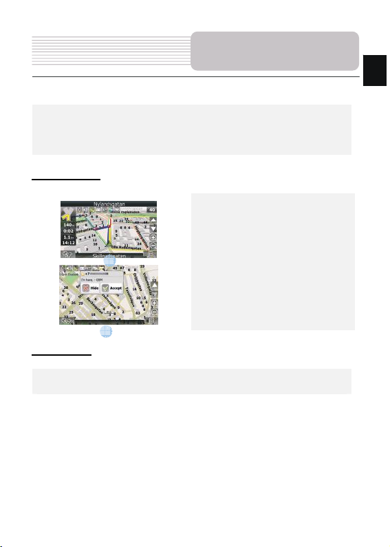
Autorouting
Autorouting
In order to create a route automatically, from the current position to the destination
point, tap with the stylus pen on the place on the map where the final point is, tap on
the “Cursor” button and in the context menu choose "Go to" (Fig. 1). The calculated
route will be shown on the map in blue color with highly visible dark border (Fig. 2).
Please, note that in case of non-routable maps, the route will represent a straight green
line from your position to the dest ination point, ignoring the existing buildings, roads, etc.
1 2
EN
EN-18

EN
Autorouting
Autorouting using search
Find an object of interest using “Search” and press it with stylus, then select “Go To”
item from the menu. Apart from this item there are also “ Insert” — add a point
between two points of existing route, and “Add” — point is added to the end of a
route and continues it. Both items are available only with existing route.
Manual route creation
The difference of this route creation method from previous t wo is what you can set a
start point and a destination point.
To create a route, press a map using stylus, press the “Cursor” (Fig. 1) button and
“Start” button after the menu appears (Fig. 2). Then find the destination point and
press “Cursor” — “Go To” (Fig. 3). If you using maps sup ports autorouting, route will
be created referring to this data and will be the shortest or the quickest. Other wise
waypoints will be connected with strait green lines.
Please note! If GPS-receiver is active, you cannot set the start point!
1 2 3
EN-19
Additional features
If your device has GPRS-module, or provides Internet connection via the
GPRS-module of your mobile phone through Blue tooth, you will be able to use
some «Navitel.Navigator» software features like «Navitel.Traffic» and
«Navitel.SMS» services.
Navitel.Traffic
Using this service you can see the traffic
situation in Russia, Ukraine, Belarus or
any other country you have official map
for. To set the service, go to “Settings” ->
1
2
Navitel.SMS
The special window will appear on the screen when you receive the Navitel.SMSI2].
Select “Hide” to hide it or ”Accept” to see options.
Note:
For more detailed information regarding the functionality of Navitel 5.0 software, please,
refer to the compete user manual on CD, or to www.prestigio.com.
«On-line services» -> ”Traffic Jams”.
When the service is active, the roads are
colorized in different colors, which mean:
red - traffic jam, pink - movement is
complicated, yellow - movement is a bit
complicated, green - favorable traffic(1).
EN-20
EN

EN
Troubleshooting
NOTE:
Immediately turn off the device and disconnect the power adapter if the
device is not working properly. Never try to repair the unit without
authorized professionals for it may damage the unit.
PROBLEM
Users can’t turn
on the unit.
There is no
sound.
There is no
picture.
POSSIBLE CAUSE
The adaptor doesn’t
connect well.
The built-in rechargeable
battery is weak.
The volume may be turned
down or mute.
The brightness may be
turned down.
POSSIBLE SOLUTION
Connect the adaptor
correctly.
Use the adaptor to supply
power or charge the
battery.
Turn up the volume or turn
on the sound output.
Adjust the brightness of the
LCD.
Make sure to use the unit
out of room; if in the
vehicle, you can use the
external GPS antenna to
solve this problem.
The unit can’t
receive satellite
signals or can’t
orient.
The unit may be obstructed
by buildings or metal block.
EN-21

PROBLEM
The unit can
receive signals
now but can’t
then; signals
received are not
stable.
Troubleshooting
POSSIBLE CAUSE
The built-in rechargeable
battery is weak.
The unit may be obstructed
by veil, such as heat
insulation paper.
Swing of the unit is too
great.
POSSIBLE SOLUTION
Use the adaptor to supply
power or charge the
battery.
Remove the veil.
Avoid great swing of the
unit.
EN
EN-22

EN
Technical specifications
MODEL
Navigation Software
GPS Chipset
Channels
Antenna
Interface
Display size
Resolution
Display type
RAM
Flash
Expansion slot
Battery type/capacity
Operating System
Speaker
Video formats supported
Audio formats supported
Earphone jack
Operating Temperature
Operating humidity
GV4700/4700BT GV5700/5700BT
Navitel Navitel
SiRF Atlas V 500MHZ SiRF Atlas V 500MHZ
64 64
Internal Internal
USB USB
4.3" 5"
480*270 800*480
TFT Touch screen TFT Touch screen
128MB, DDR2 128 MB, DDR2
2GB 2GB
Micro SD-Card slot, max
8GB
Li-polymer 950mAh Li-polymer 1250mAh
Microsoft Window CE6.0 Microsoft Window CE6.0
1w 8ohm built-in speaker 1w 8ohm built-in speaker
2.5mm mini jack 2.5mm mini jack
0~ 60ºC 0~ 60ºC
10% to 90%
non-condensing
Micro SD-Card slot, max
AVI AVI
MP3 MP3
10% to 90%
non-condensing
8GB
EN-23

PC Connection
To establish connection with PC for data access and synchronization, please execute
setup file included in the Driver/Documentation CD or download the file from Microsoft
website to install:
Microsoft Active Sync® software for operating system Microsoft XP or earlier
versions
(http://www.microsoft.com/windowsmobile/en-us/downloads/microsoft/activesync-dow
nload.mspx)
and/or
Microsoft Mobile Device Center® software for operating system Microsoft Vista
(http://www.microsoft.com/windowsmobile/en-us/downloads/microsoft/device-center-d
ownload.mspx).
Please refer to its user manual for more detailed instructions.
Disclaimer
As the Prestigio products are constantly updated and improved, your device may have a
slightly different appearance or modified functionality than presented in this Quick start
Guide.
EN-24
EN

EN-25
 Loading...