

Page 1

Contents
1. Important safety instructions ………………………………..…...
2. Accessories ………………………………………………………….
3. View of main unit …………………….……………………………...
4. Device connections ……………………….…………....................
5. Cautions on battery charging ………….……………..................
6. Getting started ………………………………………………………
7. Device Settings…………………………………………..…………..
8. Bluetooth Function …………………………….…………………...
9. FM Function ………………………...…………………....................
10. Programme Interface………...……………….…….......................
11. Autorouting …..……………………………....................................
12. Additional Features…………………………………………………
13. Troubleshooting …………………………………………………….
EN
2
3
4
6
8
9
10
11
15
16
20
22
23
EN-1
Page 2
Important Safety
EN
Instructions
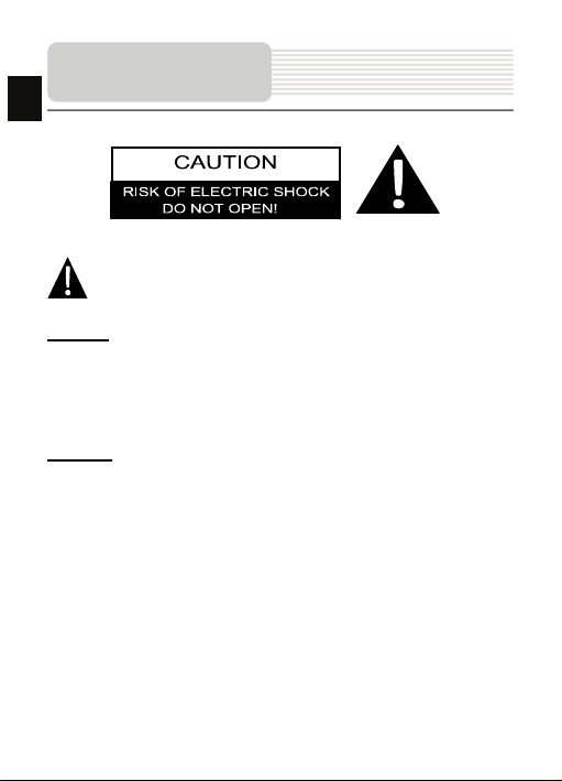
The exclamation point within an equilateral triang le is intended to alert the
user to the presence of important operating and maintenance (servicing)
instructions in the literature accompanying the ap pliance.
CAUTION
1. To reduce the risk of electric shock, do not remove the cover (or back). No
user-serviceable parts inside. Refer servicing to qualified service personnel.
2. The manufacturer should not hold responsibility for the damage caused by any
substitutions and modifications of the produ ct without authorization from the
manufacturer or authorized unit
.
WARNING
The device should not be exposed to dripping or splashing and no objects filled with
liquids should be placed on the device.
EN-2
Page 3
Accessories
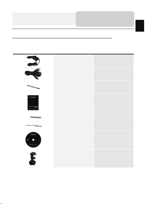
Prestigio GeoVision 4466/5466/5466BTFM–Accessories List
ITEM NAME QTY
EN
Car Charger 1
USB Cable 1
Stylus Pen 1
User Manual 1
Warranty Card 1
Driver/Document CD 1
Mounting Cradle
EN-3
1
Page 4
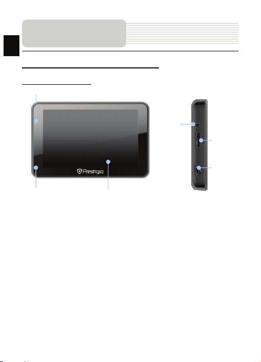
View of Main Unit
EN
Prestigio GeoVision 4466/5466/5466BTFM
Front and Side View
2
3
4
6
1. LCD Touch Screen
Tap the screen with touch pen or finger to select menu commands or to enter
information.
2. Battery Status Indicator
The indicator glows in bright green color when battery is fully charged and in red
color when charging.
3. Earphone Jack
Connects to earphones or headsets.
4. microSD Slot
Receiving microSD memory card for data access or m emory expansion.
5. mini USB Port
Connection to USB Cable for data access or batte ry charging
6. Microphone
Records sound.
1
EN-4
5
Page 5
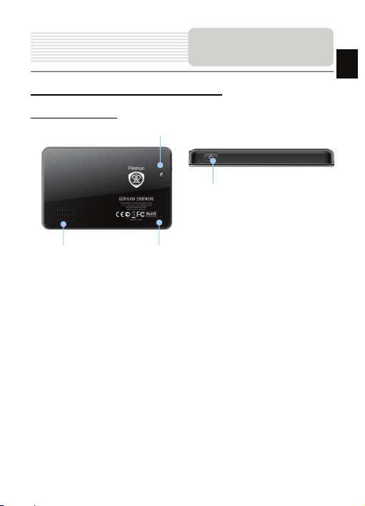
View of Main Unit
Prestigio GeoVision 4466/5466/5466BTFM
Rear and Top View
3
4
EN
1. Speaker
2. Reset Button
3. Light Sensor
4. Power Button
1
Emits sound, voice or music.
Press to reboot the device.
Adjust the brightness of touch screen
Press to power the device ON/OFF.
2
EN-5
Page 6
Device Connections
EN
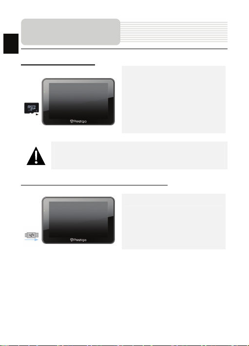
Inserting microSD Card
NOTE:
Please always make sure that no application is access ing the microSD
card before extraction.
z To insert a microSD card, place the
connector towards the device and the
card label towards the front side of
the device.
z To remove a microSD card, gently
press the edge of the card to release
the safety lock and pull the card out
of the slot.
Connecting to External USB Device (Charging)
z Insert the USB connector into the
appropriate USB port.
z Insert the other USB connector into
the USB port on PC to start charging.
EN-6
Page 7
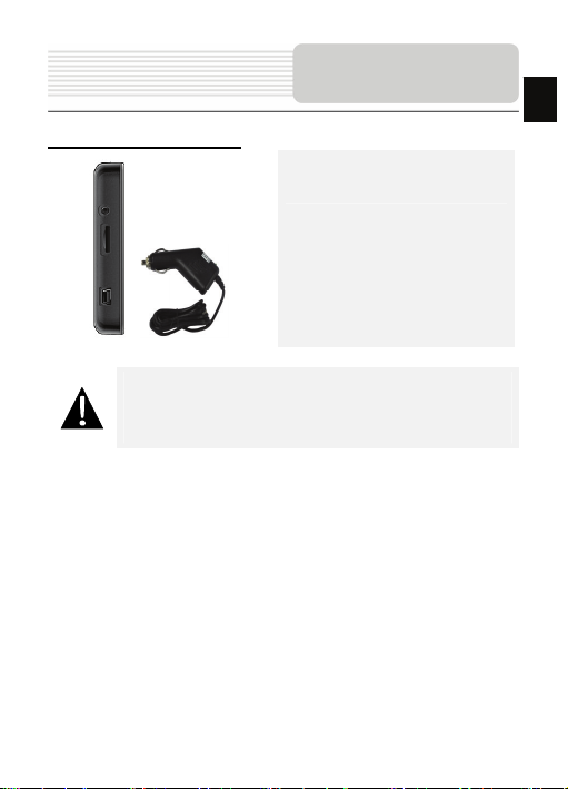
Connecting to Car Charger
NOTE:
Please connect the car charger to vehicle 12 V accessory/cigarette
socket after the vehicle engine is started to protect t he device from
sudden surges in current.
Device Connections
z Insert the USB connector into the
appropriate USB port.
z Insert car charger connector into
vehicle 12V accessory/cigarette
socket to start charging.
EN-7
EN
Page 8

Cautions on Battery
ging
EN
Char
About Rechargeable Battery
The device is equipped with a built-in re chargeable battery. Please fully charge the
battery (for at least 5 hours) before initial u se. The battery status indicator glows in red
color when charging and turns bright green co lor when charging is complete. Charging
time is approximately 4 hours.
Working conditions and precautions for the rechargeable battery
z Devices with new batteries should be fully cha rged before initial use.
z It is not necessary to start charging the device before the battery is fully
discharged.
EN-8
Page 9
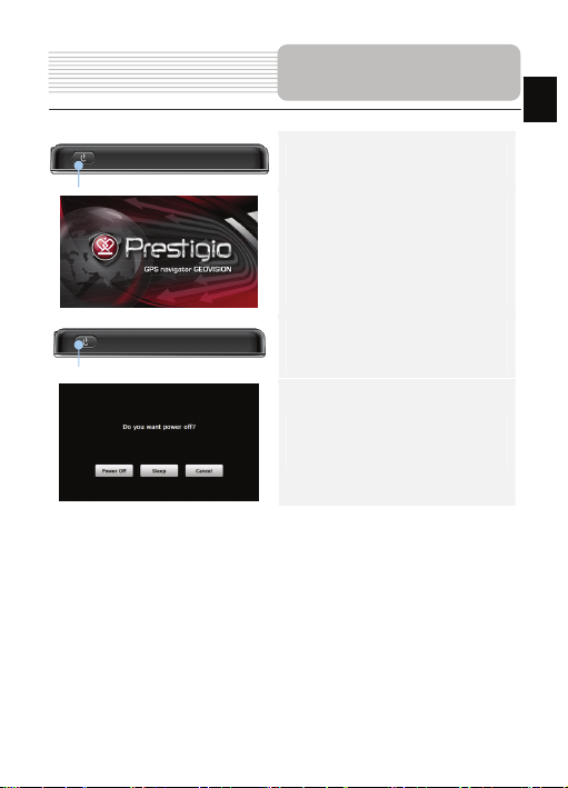
Getting Started
1. Press and hold Power Button to turn
on the device.
2. Shortly after the greeting screen is
shown, the main menu will be
displayed.
3. Tap the corresponding buttons with
touch pen included to navigate
through various functions.
4. Press and hold Power Button to turn
the device off or to allow the device to
enter sleep mode.
5. Tap Sleep icon to put the device to
sleep mode or Power Off icon to turn
the device off.
EN-9
EN
Page 10
EN
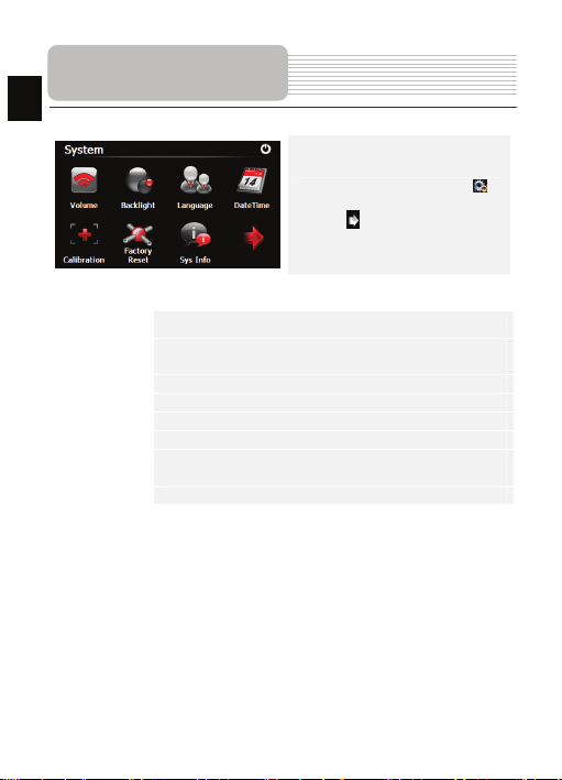
Device Settings
z In the main menu, tap on to
enter the device settings.
z Tap to displa y other settings.
Vol um e
Backlight
Language Select desired language.
DateTime Set up Time Zone/Date/Time.
Calibration Calibrate the screen when position deviat ion occurs.
FM transmitter Transmit audio signals from the navigator to radio sets.
USB
Factory Reset Restore all system settings to factory default values.
Adjust sound volume, mute device, or enable warning messages.
Adjust the brightness of touch screen, enab le/disable auto
backlight.
Set the data transmission mode between the nav igator and
computer.
EN-10
Page 11
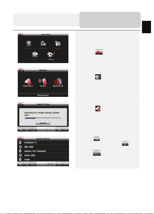
Bluetooth Function
(GeoVision 5466BTFM)
1. Tap on Blueto oth icon on the main
menu to start using Bluetooth
function.
2. Tap on to exit the current
function.
3. Tap on in Phone Me nu to enter
Settings
4. Tap on to search for mobile
phones automatically (Note: mobile
phone’s Bluetooth function should be
enabled beforehand)
5. Tap on to begin new search for
Bluetooth devices; tap on to
delete selected Bluetooth devices;
tap on to connect the selected
Bluetooth device with PND
EN
EN-11
Page 12
Bluetooth Function
EN
(GeoVision 5466BTFM)
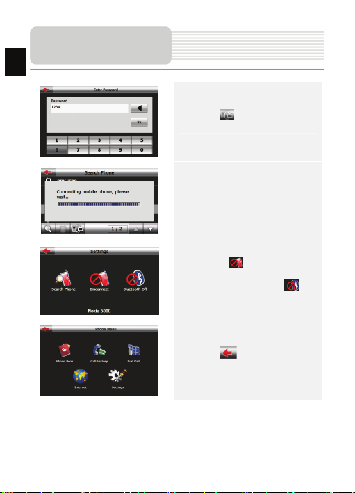
6. Tap on to pair, and as request
to enter the PIN code-1234
7. After successful connection, the
interface will show as.
8. Tap on to stop the
connection between the PND and
Bluetooth device; tap on to
turn off the Bluetooth function.
9. Tap on to back to the Phone
Menu interface
EN-12
Page 13
Bluetooth Function
(GeoVision 5466BTFM)
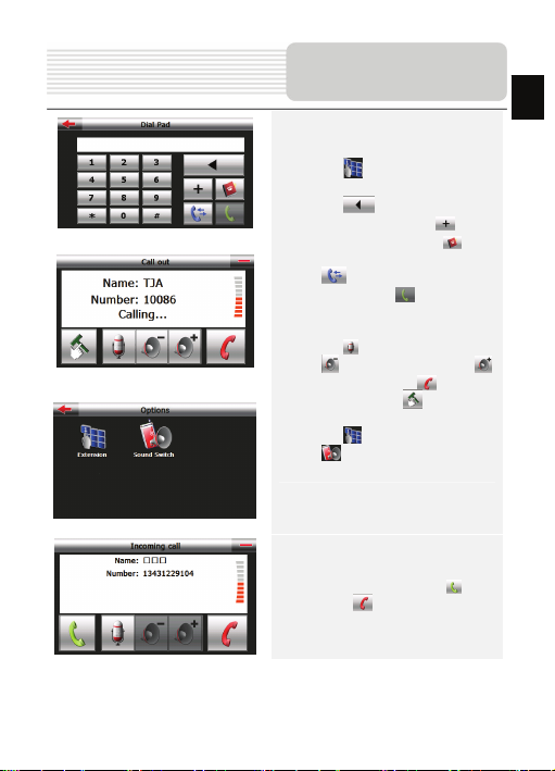
10. Tap on on Bluetooth interf ace
to enter Dial pad
11. Tap on to delete the latest
inputted number; Tap on to
input the symbol+. Tap on to
open the phone book interface; Tap
on to enter the call history
interface; Tap on to make a
phone call, and Call out interface will
be shown
12. Tap on to stop audio input; Tap
on to volume down; Tap on
to volume up; Tap on to stop
calling out; Tap on to open the
Options interface.
13. Tap on to enter Dial Pad; Ta p
on to switch sound between
mobile phone and PND.
EN
14. For a incoming call, tap on to
answer / to reject it
EN-13
Page 14
Bluetooth Function
EN
(GeoVision 5466BTFM)
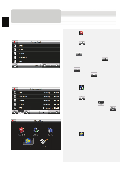
15. Tap on in Phone Me nu interface to
enter Phone Book
16. Tap on to transfer data of
contacts from mobile phone to PND; the
icon shows current page/total
pages of contacts. Tap on to
enable quick search for a contact; Tap
on to view the previous page of
contacts; Tap on to view the next
page of contacts;
17. Tap on in Phone Menu to enter
the Call History.
18. Tap on to check records of the
incoming calls; Tap on to check
records of outgoing calls; Tap on
to check records of the missed calls.
19. Tap on in Phone Menu interface
to browse the web
EN-14
Page 15
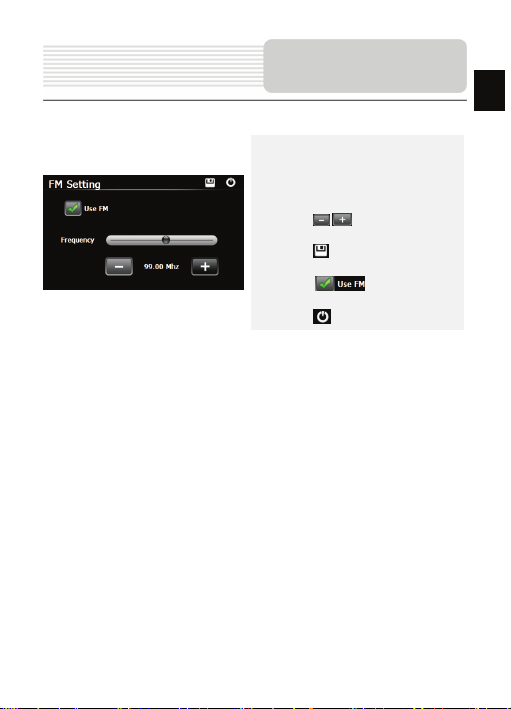
FM Function
(GeoVision 5466BTFM)
1. Tap on Function icon on the main
menu.
2. Tap on FM icon to start using
Bluetooth function.
3. Tap on / or drag the cursor to
tune FM frequency down/up.
4. Tap on to save current FM
station.
5. Tap on to enable th e FM
function.
6. Tap on to exit.
(Note: Please make sure GPS is connected to the car charger before using FM
Transmitter)
EN-15
EN
Page 16

Program interface
EN
No. Name Function
1 Next maneuver
2 Compass
3 Sound Press this button to turn on/off voice and sound effects.
Information
4
5 GPS-cursor If GPS connection is established, displays your cur rent location.
6 Route Route you are currently navigating displays as a wide blue line.
7 Search
Information
8
9 Scale Map current scale.
Next maneuver on the way and distance up to i t. Press this Icon
to open route options menu.
Press the compass loon to edit map rotation m ode, map view
and day/night mode.
Display time until the end of the trip, total route length, and
panels
arrival time.
Press this button to enter the search menu and to find specific
address or object (you can find more Info ab out Search In
~Functionality~ section)
Shows street name you are currently moving o n. Available only
if GPS or GLONASS connection is established. If there is no
panel
street name, the direction will be shown.
EN-16
Page 17

Program interface
No. Name Function
Return to
10
current
location
11 Autoscale
12 MENU Press to en ter the Main Menu.
13 Zoom Out Decrease map scale.
14 Zoom In Increase map scale.
15 Map slope
Speedcam
16
window
17 Speed Current speed. Available only with GPS connection established.
Information
18
19 Battery
20 GP S
You can see the green arrow at the top of t he screen if the map
was moved relative to your position. Press it to r eturn view to
your current location.
If you zoom In/out with ~Autozoom~ function activ ated, this
function will deactivate for a period according to settings. Press
this button to activate ~Autozoom~ function m anually.
Press "Up"/"Down" to slope the map. Available only if scale is
between 5 and 300 m.
When you approach a speed camera with visual warnings being
activated the window will appear In upper right comer at the
screen. This window shows you permitted speed and distance
left. Press the window to turn On/Off speed exceeding
sound warnings.
Shows street name you are currently moving o n. Available only
if GPS or GLONASS connection is established. If there is no
panel
street name, the direction will be shown.
Icon displays battery life. Press it to open windo w with full
information about battery life and remaining m emory.
GPS connection button. Green icon - conne ction enabled, white
icon – function disabled. Green icon also h as a dot at different
color: red - no connection, yellow - poor connection, green -
connection established.
EN-17
EN
Page 18

Program interface
EN
No. Name Function
21 Waypoint
22 “SaveWP” Saves current mark on map as a wa ypoint.
Waypoints are manually created by the user and display with
red flags on a map.
EN-18
Page 19

Program interface
No. Name Function
23 “Cursor ” Shows the menu of mark on ma p
24 Mark on map
25 Track record
26 Traffic Jams Press this icon to edit "Navitel.Traffic Jams." function.
27 Navitel.S MS
28 “Go To” “Mark on map” becomes the end point of the route.
29 Insert “Mark on map” becomes the middle point of the route
30 “Add”
31 “Start”
32 Back
33 Info Info about current “Mark on map” position. Tap to see more.
34 Back to map Returns to the “Map” page
35 Object of interest
Touch the screen with a stylus to set a mark . You can save this
mark as a way point add it to the route or see object’s
characteristics the mark was set on.
Track record. Green icon - track record enabled, white icon
function disabled.
Button is used to read/send SMS-messages and to work with
coordinates given there. Figure near the icon d isplays number
of unread messages.
“Mark on map” becomes the end point of the route, whereas
previous end point becomes middle point.
“Mark on map” becomes the start point of the route. You should
turn off your GPS/GLOANASS-receiver.
Depends on way you got to this screen , return s back to “Map”
screen or to find menu.
Different objects on map (traffic lights, metro sta tions, petrol
stations etc.).
EN-19
EN
Page 20

EN
Autorouting
Autorouting
In order to create a route automatically, from the current position to th e destination
point, tap with the stylus pen on the place on the map where the final point is, tap on
the “Cursor” button and in the context menu choose "Go to" (Fig. 1). The calculated
route will be shown on the map in blue color with highly visible dark border (Fig. 2).
Please, note that in case of non-routable maps, the route will represent a straight green
line from your position to the destination point, ignoring the existing buildings, roads, etc.
1 2
EN-20
Page 21

Autorouting
Autorouting using search
Find an object of interest using “Search” and pre ss it with stylus, then select “Go To”
item from the menu. Apart from this item there are also “Insert” — add a point
between two points of existing route, and “Add ” — point is added to the end of a
route and continues it. Both items are availab le only with existing route.
Manual route creation
The difference of this route creation method from previous two is what you can set a
start point and a destination point.
To create a route, press a map using stylus, press the “Cursor” (Fig. 1) button and
“Start” button after the menu appears (Fig. 2). Then find the destination point an d
press “Cursor” — “Go To” (Fig. 3). If you using maps support autorouting, route will
be created referring to this data and will be the shortest or the quickest. Other wise
waypoints will be connected with strait green lines.
Please note! If GPS-receiver is active, you cannot set the start point!
EN
1 2 3
EN-21
Page 22

Additional features
EN
If your device has GPRS-module, or provide s Internet connection via the
GPRS-module of your mobile phone throug h Bluetooth, you will be able to use
some «Navitel.Navigator» software features like « Navitel.Traffic» and
«Navitel.SMS» services.
Navitel.Traffic
Using this service you can see the traffic
situation in Russia, Ukraine, Belarus or
any other country you have official map
for. To set the service, go to “Sett ings” ->
1
2
«On-line services» -> ”Traffic Jams”.
When the service is active, the roads are
colorized in different colors, which mean:
red - traffic jam, pink - movement is
complicated, yellow - movement is a bit
complicated, green - favorable traffic(1).
Navitel.SMS
The special window will appear on the scre en when you receive the Navitel.SMSI2].
Select “Hide” to hide it or”Accept” to see op tions.
Note:
For more detailed information regarding the functionality of Navitel 5.0 software, please,
refer to the complete user manual on CD, or to www.prestigio.com.
EN-22
Page 23

Troubleshooting
Take the steps described in the tables below to solve simple problems before contactin g
customer service centers.
NOTE:
Immediately turn off the device and disconnect the power adapter if the
device is not working properly. Never try to repair the unit without
authorized personnel for it may damage the unit.
PROBLEM
Users cannot
turn on the unit.
There is no
sound.
There is no
picture.
The unit cannot
receive satellite
signals or cannot
orient.
POSSIBLE CAUSE
The adaptor is not
connected well.
The built-in rechargeable
battery is weak.
The volume may be turned
down or mute.
The brightness may be
turned down.
The unit work may be
obstructed by buildings or
metal constructions.
POSSIBLE SOLUTION
Connect the adaptor
correctly.
Use the adaptor to supply
power or charge the
battery.
Turn up the volume or turn
on the sound output.
Adjust the brightness of the
LCD.
Make sure to use the unit
out of room; if in the
vehicle, you can use the
external GPS antenna to
solve this problem.
EN
EN-23
Page 24

EN
Troubleshooting
PROBLEM
Irregularity or
instability in
signal receiving.
POSSIBLE CAUSE
The built-in rechargeable
battery is weak.
The unit may be obstructed
by material, such as heat
insulation paper.
POSSIBLE SOLUTION
Use the adaptor to supply
power or charge the
battery.
Remove the material.
PC Connection
To establish connection with PC for data access and synchronization, please execute
setup file included in the Driver/Documentation C D or download the file from Microsoft
website to install:
Microsoft Active Sync® software for operating syst em Microsoft XP or earlier
versions
(http://www.microsoft.com/windowsmobile/en-us/downloads/microsoft/activesync-dow
nload.mspx)
and/or
Microsoft Mobile Device Center® software for operating system Microsoft Vista
(http://www.microsoft.com/windowsmobile/en-us/downloads/microsoft/device-center-d
ownload.mspx).
Please refer to the Microsoft website for more detailed inst ructions.
EN-24
Page 25

Содержание
1. Инструкции по безопасности ………………………………
2. Список аксессуаров ….…………………………………......
3. Обзор устройства …..………………….………………... ....
4. Системные подключения ….……………….………….. .....
5. Питание устройства ................………………………… .....
6. Начало работы …...……………………………………........
7. Настройки …………….........……………………….………..
8. Функция Bluetooth ……………………………………….......
9. Функция FM-передатчика …………………………….........
10. Интерфейс программы ……………....……..……….…......
11. Автороутинг ………………………………....….…….….......
12. Дополнительно …………………………...………….………
13. Ре ше ние проблем …..…………………………………........
RU
2
3
4
6
8
9
10
11
15
16
20
22
23
RU-1
Page 26

RU
Инструкции по
безопасности
Значок восклицательного знака, вписанный в равносторонний
треугольник, обращает внимание пользователя на важн ый пункт,
изложенный в руководстве пользователя.
ПРЕДОСТЕРЕЖЕНИЕ
1. Чтобы устранит ь риск пора жения электрическим током, не от крыва йте корпус
устрой ства. Внутри корпуса нет частей ил и деталей, ремонт которых может
быть выполнен самостоятельно. Предоставьте всю работу по устранен ию
неисправностей квалифицированному техн ическом у персоналу.
2. Производител ь не несет ответственно сть за повреждения, вызванные
несанкционированными изменениями в конструкции данного устройс тва.
ПРЕДУПРЕЖДЕНИЕ
Не допускайте попадания жидкости внутрь ус трой ства .
RU-2
Page 27

Список аксессуаров
Prestigio GeoVision 4466/5466/5466BTFM – Список аксессуаров
Изображение Описание Кол-во
Автомобильное зарядное
устройство
Кабель USB 1
RU
1
Электронное перо 1
Автомобильное
креплени е
Руководство
пользователя
Гарантийный талон 1
1
1
Компакт-диск с
драйвером и
документацией
RU-3
1
Page 28

Обзор устройства
RU
Prestigio GeoVision 4466/5466/5466BTFM
Вид спереди и сбоку
2
3
6
1. Сенсорный ЖК-экран
Для выбора команд в меню или ввода информации нажмите по нему пальцем
или электронным пером.
2. Индикатор заряда батареи
При полном заряде батареи индик атор горит ярко-зелены м цветом, в
процессе зарядки - красным.
3. Разъем для на ушников
Используется для подключения наушников.
4. Слот для карт памяти стандарта microSD
Используется
расширения памяти.
5. USB порт
Используется для подключения USB кабеля для получения данных или
зарядки батареи.
6. Микрофон
Осуществляет запись звука.
для установ ки карт памяти microSD для получения данных или
1
RU-4
4
5
Page 29

Вид ззади и сбоку
Обзор устройства
3
4
RU
1
1. Динамик
Используется для воспроизведения звука, голос а или музыки.
2. Кнопка сброса
Нажмите для перезапуска устройства.
3. Светочувствительный датчик
Регулировка яркости сенсорного экрана.
4. Кнопка питания
Используется для включения и выключения устр ойс тва.
2
RU-5
Page 30

С
RU
подключения
Внимание:
Перед извлечением microSD карты убедитесь, что она в данный
момент не работает ни с одним приложением.
Подключение к внешнему USB-устройству (зарядка)
z Уст ан ав ли ва я microSD карту,
поверните ее коннектором к
устройству (этик етка должна быть
повернута к передней панели
устройства).
z Чтобы извлечь microSD карту,
слегка нажмите на край карты,
чтобы снять защитную защелку, и
вытяните карту из слота.
z Подключите USB-коннектор к
соответствующему USB-порту.
z Подключите другой USB-коннектор
к USB-порту на ПК, чтобы начать
зарядку.
истемные
RU-6
Page 31

С
истемные
подключения
Подключение к автомобильному адаптеру питания
z Подключите USB-коннектор к
соответствующему USB-порту.
z Подключите коннектор
автомобильного зарядного
устройства к прикуривателю (12В),
чтобы начать зарядку.
Внимание:
Рек ом ен дуе тся подключать автомобильное зарядное устр ойств о к
прикуривателю (12В) после зажигания двигател я, чтобы защитить
устрой ство от резких изменений напряжения.
RU-7
RU
Page 32

П
RU
устройства
Использование батареи
Ваше портативное устройств о имеет встроенную перезаряжаемую аккумуляторную
батарею. При первом использовании уст ройст ва необходимо полностью зарядить
батарею (как минимум 5 часа). Индикатор заряда батареи горит красным цветом во
время зарядки и ярко-зеленым после ее окончания. Время зарядки составляет
примерно 4 часа. Время работы при полностью заряжен ном аккумуляторе без
подзарядки составляет около 1 часа.
Обратите внимание при работе с батареей:
z Новая батарея должна быть полностью заряжена при первом
использовании.
z Нет необходимости заряжать устройс тво до полной разрядки батареи.
RU-8
итание
Page 33

Начало работы
1. Чтобы включить устройство,
нажмите и удер жи ва йт е кнопку
питания.
2. Вскоре после при ветствия на
экране появится главно е меню.
3. Для выбора функций
воспользуйтесь электронным
пером.
4. Нажмите и уде ржи ва йте кнопку
питания, чтобы выключить
устрой ство или перевести его в
спящий режим.
5. Нажмите кнопку Спящий режим ,
чтобы перевести ус трой ство в
спящий режим, или Выкл., чтобы
выключить его.
RU-9
RU
Page 34

RU
Громк ость
Яркость Регул ир ов ка ярк ости экрана.
Язык Выбор языка меню.
Время и дата Настройка часового пояса, даты и времени.
Калибровка Калиб ровка экрана в случае отклонений.
FM-передатчик Передача аудио-сигнала с уст рой ства на радио-приемник.
USB
Сброс настроек Сброс всех системных настроек до заводских.
Настройки
z В главном меню нажмите на кнопку
, чтобы зайти в меню настроек.
z Нажмите , чтобы вывести другие
настройки.
Регул ир ов ка гром кости, включение и выключение звука или
сигнала нажатия.
Настройки передачи данных между навигатором и
компьютером.
RU-10
Page 35

Функция Bluetooth
(GeoVision 5466BTFM)
1. Нажмите на символ Bluetooth в
главном меню, чтобы начать
использование функции Bluetooth.
2. Нажмите , чтобы покинуть
эту функцию.
3. Нажмите в Меню телефона,
чтобы зайти в Настройки.
4. На жмите , чтобы начать
автоматический поиск мобильных
телефонов (Вн имание: на
мобильном телефоне должна
быть активирована функция
Bluetooth)
5. На жмите , чтобы начать
новый поиск устройств Bluetooth;
нажмите , чтобы уда лит ь
выбранное устро йство Bluetooth;
Нажмите , чтобы соединить
выбранное устро йство Bluetooth с
навигатором.
RU-11
RU
Page 36

Функция Bluetooth
RU
(GeoVision 5466BTFM)
6. Нажмите для сопряжения и
введите PIN-код – 1234.
7. После успешн ого соединения
появится этот интерфейс..
8. Нажмите , чтобы прервать
соединение между навигатором
и устр ойст вом Bluetooth;
Нажмите , чтобы
выключить функцию Bluetooth.
9. Нажмите , чтобы вернуться в
Меню телефон а.
RU-12
Page 37

Функция Bluetooth
(GeoVision 5466BTFM)
10. Нажмите в интерфейсе
Bluetooth, чтобы вывести Панель
набора.
11. Нажмите , чтобы удал ить
последнюю введенную цифру,
, чтобы ввести символ +.
Нажмите , чтобы открыт ь
телефонную кн игу, , чтобы
открыт ь историю звонков; нажмите
RU
, чтобы позвонить. Появится
интерфейс вызова.
12. Нажмите , чтобы выключить
микрофон; Нажмите , чтобы
снизить громкость; Нажмите ,
чтобы увеличи ть громкость;
Нажмите , чтобы прервать
звонок; Нажмите , чтобы
открыт ь список опций.
13. Нажмите , чтобы вывести
Панель набора; Нажмите ,
чтобы переключить зв ук между
мобильным телефоном и
навигатором.
14. При входящем звонке нажмите
, чтобы ответить/ , чтобы
отмени ть.
RU-13
Page 38

Функция Bluetooth
RU
(GeoVision 5466BTFM)
15. Нажмите в Меню телефона,
чтобы зайти в телефонную книгу.
16. Нажмите , чтобы переслать
данные контакта с мобильного
устрой ства на навигатор; символ
показывает текущую
страницу/общее количество страниц
контактов. Нажмите , чтобы
включить быстрый поиск контакта;
Нажмите , чтобы пр осмотреть
предыд ущую страницу с контактами;
Нажмите , чтобы пр осмотреть
следующую страницу с контактами.
17. Нажмите в Меню телефона,
чтобы зайти в Историю звонков.
18. Нажмите , чтобы просмотреть
список входящих звонков; Нажмите
, чтобы просмотреть список
исходящих звонков; Нажмите ,
чтобы просмотреть список
пропущенных звонков .
RU-14
Page 39

Функция Bluetooth
(GeoVision 5466BTFM)
19. Нажмите в Меню телефона,
чтобы выйти в Интернет.
RU
Функция FM-передатчика
(GeoVision 5466BTFM)
1. Нажмите на кнопк у Функция в
главном меню.
2. Нажмите кнопк у FM, чтобы
запустить функцию
FM-передатчика.
3. С помощью кнопок / или
курсора Вы можете изменить
частоту.
4. Нажмите , чтобы сохранить
FM-частоту.
5. Нажмите , чтобы
включить функцию
FM-передатчика.
6. Нажмите , чтобы выйти.
RU-15
Page 40

рогр
RU
Интерфейс
п
аммы
No. Название Краткое описание функций
Следующий
1
маневр
2 Компас
3 Звук
Информаци-
4
онная панель
5 GPS-курсор
6 Мар шрут
Знак предстоящего маневра. На серо м фоне – различные
повороты, развороты, расстояние до след ующего маневра
в метрах или километрах и т.д. Нажатие по знаку –
прекращение ведения по маршруту и другие опции
маршрута.
Нажатие на иконке компаса открывает контекстное меню. В
этом меню Вы можете настроить режим вращения карты,
вид карты и дневной/ночной режимы карты.
Нажатие на эту кнопк у включает и отключает звуковые
эффекты и голос овые подсказки в программе.
Содержит информацию о времени до следующего маневра,
общей длине маршрута и времени прибытия в конечную
точку.
Отображает Ваше текущее местоп оложение при уста нов-
ленной связи со спутниками.
Маршрут, по которому осуществляется навигация, обозна-
чается широкой линией желтого цвета.
RU-16
Page 41

Интерфейс
программы
No. Название Краткое описание функций
7 Поиск
Информаци-
8
онная панель
9 Масштаб Текущий масштаб карты.
Возврат в те-
10
кущее место-
положение
Автомати-
ческое
11
масштабиро-
12 МЕНЮ Нажмите для входа в главное меню программы.
13 Уменьшить Уменьшение масштаба карты.
14 Увеличить Увеличение масштаба кар ты.
15 Наклон карты
16 Рада р
Нажмите на данную кнопку для перехода к меню поиска
нужного адреса или объекта (более подробная
информация о системе поиска указана в разделе
“Функциональные возможности”)
Отображает название проезжей части, по которой в данный
момент осуществляет ся движение
Данная кнопка появляется в правой части дисплея в том
случае, если карта была сдвинута относительно Вашего те-
кущего местоположения. Нажмите на кнопку, чтобы совмес-
тить центр карты с Вашим тек ущим местоположением.
Если в настройках автоматическое масштабирование было
включено, но во время движения по маршруту Вы с
помощью кнопок «Плюс» и «Минус» поменяли масштаб, то
автоматическое масштабирование выключается на
вание
заданный в настройках период времени. Быстро включить
его обратно можно при помощи этой кно пки.
Стрелка вверх увеличивает наклон карты, в своем
максимальном положении наклона карта переходит в вид
псевдо 3D, работающий на масштабах от 5м до 300м.
Стрелка вниз уменьшает наклон карты.
Если в настройках визуальное предупреждение было вклю-
чено, то при приближени и к радару на дороге в правом
верхнем углу появляется панель. На ней указана
максимальн о допустимая скорость движения и расстояние,
оставшееся до радара. Нажатие на кнопке включает/
выключает звуковые предупреждения о превышении
скорости.
RU-17
RU
Page 42

рогр
RU
Интерфейс
п
аммы
No. Название Краткое описание функций
17 Скорость
Информаци-
18
онная панель
19 Батарея
Соединение
20
спутниками
Текущая скорость движения. Отображается при наличии
соединения со спутниками.
Отображение названия проезжей части, следующей за
текущим манев ром.
Иконка отображает количество остав шегося заряда
батареи в виде делений. Нажатие на данной кнопке
отображает информацию об остав шемся заряде в
процентах и свобод ной памяти в МБ.
Кнопка соединения со спутни ками. Зеленый значок –
соединение включено, белый – выключено. На зеленой
со
иконке есть маленький круг. Если круг красный -
соединение со спутниками не устано влено , желтый –
плохое соединение, зеленый – соедине ние установ лено.
RU-18
Page 43

Интерфейс
программы
No. Название Краткое описание функций
21 Путевая точк а
Кнопка
22
“Сохранить”
На карте красными флажками обозначаю тся путевые точки,
созданные пользователем. Нажатие на точку открывает
внизу страницы панель с кнопка ми для работы с путевыми
точками.
Сохраняет текущую точку на карте как путевую точку, чтобы
впоследствии быстрее находить её.
RU-19
RU
Page 44

рогр
RU
Интерфейс
п
аммы
No. Название Краткое описание функций
Кнопка
23
“Курсор”
Точка на
24
25 Запись трека
Пробки от
26
Навител
27 Навител .SMS
Кнопка
28
“Поехать”
Кнопка
29
“Заехать”
Кнопка
30
“Продолжить”
Кнопка
31
“Начать”
32 Возврат
Информаци-
33
онная панель
Возврат на
34
Объект инфра -
35
структуры
При нажатии на кнопку появляется меню работы с Точкой
на карте.
Коротким нажатием на карту можно поставить точку. Такую
точку можно сохранить как путевую, добавить в маршрут,
карте
посмотреть ее свойства и т.д.
Кнопка записи трека. Зеленый цвет значка - запись трека
включена, белый - выключена.
Значок, предназначенный для настройки сервиса от
компании Навител. См. раздел «Пробки».
Кнопка предназначена для чтения/отправки
SMS-сообщений и работы с указанными в них
координатами.
Помечает текущее расположение точки на карте как
конец маршрута.
Помечает текущую точку на карте как промежуточную
точку маршрута. Кнопка активна толь ко при
проложенном маршруте.
Помечает текущую точку на карте как конец маршрута,
при этом уже существующий конец маршрута
становится промежуточной точкой. Кнопка активна
только при проложенном маршруте.
Определяет старт маршрута. GPS при этом необходимо
отключить.
В зависимости от тог о, как Вы попали в данное меню,
кнопка либо возвращает в адресный поиск, либо
возвращает к обычному просмотру карты.
Показывает информацию о текущем расположении точки
на карте.
Переход к просмотру карты.
карту
Различны е объекты, нанесенные на карту (светофо ры, с
танции метро, АЗС и т.д.).
RU-20
Page 45

Автороутинг
Автороутинг
Эта функция работает только на картах, которые содержат информацию для
прокладки маршрутов. Для того, чтобы про грамма автоматически проложила
маршрут от Вашего ме стоположения до конечного пункта следования, нажмите на
место на карте, где находится конечная точк а, выберите меню “Курсор”, и в
появившемся меню - кнопку «Поехать» (Рис. 1). Проложенный маршрут будет
выделен на карте гол убым цветом с ярко-выраженной темн ой каймой (Рис. 2).
Обратите внимание на то, что на картах, не содержащих информацию для
прокладки маршрутов, маршрут будет проложен как прямая линия зеленого цвета,
соединяющая Ваше местонахождение и конечную точку, игнорируя все здани я,
дороги и т.п.
1 2
RU-21
RU
Page 46

RU
Автороутинг
Автороутинг из поиска
Зайдите в раздел «Поиск», найдите необходимый вам объект, до которого
нужно проложить маршрут, нажмите на него и в открыв шемс я меню выберите
«Поехать». Кроме данного пункта меню, есть еще «Заехать» — добавить точку
между двумя точками уже существующего маршрута, она станет второй по
счету и «Продолжить» — точка добавляется в конец маршр ута, продолж ая его.
Оба этих пункта доступны только в сл учае, когда на карте уже есть созданный
маршрут.
Ручное создание маршрута
Этот тип создания маршрута такой же автоматический, как и первые два, с
одним только различием – зде сь Вы можете задать точку отправле ния и точ ку
прибытия.
Для создания маршрута нажмите на карте в первой точ ке маршрута. В нижней
части экрана выберите кнопку «Курсор» (Рис. 1), а в появившемся меню -
кнопку «Начать» (Рис. 2). Затем найдите конечную точку маршрута и внизу
страницы нажмите кнопку «Курсор» - «Поехать» (Рис.3). В случае, если карта
содержит информацию для автоматической прокладки, маршрут будет создан
на основании этих данных, и будет проходить кратчайшим или наименьшим по
времени путем от начальной до конечной точки. В ином случае, маршрут
движения будет соединять точки маршрута прямыми линиями.
Обратите внимание, что при включенном GPS-приемнике уста нови ть
начальную точку маршрута невозможно!
1 2 3
RU-22
Page 47

Дополнительно
В случае, если модель Вашего навигатора обладает вcтроенным
GPRS-модулем или имеет возможность выхода в Интернет через GPRS
модуль вашего телефона по Blueto oth соединению, Вам будут доступны
некоторые полезные дополнительные функции, такие как «Навител. Пробки» и
«Навител. SMS».
«Навител. Пробки»
Данный сервис предоставляет
информацию о загруженности дорог на
всей территории Росси и, Укр аи ны и
Беларуси. Чтобы его настроить,
нажмите «Настройки» -> «Другое» ->
«Пробки». Цвет, в который окрашена
1
2
«Навител. SMS»
При получении SMS-сообщения на экране появляется соответствующее
окно[2]. Выберите “отклонить”, чтобы закрыть окно или “принять” для
отображения возможных опций.
дорога на карте, будет зависеть от
степени затрудненности движения:
Красный – пробка, Оранжевый –
движение затруднено,
Тёмно-зеленый – движен ие немного
затруднено, зеленый – благоприятная
дорожная ситуация[1].
RU-23
RU
Page 48

Решение проблем
д
р
RU
При наличии проблем в работе устройства, прежде, чем обратиться в сервисный
центр, сверьтесь с приведенной ниже таблицей.
Внимание:
Немедленно выключите устройство и отключите его от сети при
наличии неполадок в работе. Никогда не пытайтесь самостоятельно
устран ить неисправности, доверьте все ремонтные работы
специалистам сервисного центра.
Устройство не
включается.
Звук отсутствует.
Отсутствует
изображение.
ПРОБЛЕМА
ПРИЧИНА
Адаптер прохо
соединен.
по
Батарея разряжена.
Громкость слишком мала.
Яркость экрана слишком
мала.
РЕШЕНИЕ
Проверьте правильность
подключения адаптера.
Подключите адаптер для
зарядки батареи .
Увел ич ьте громк ость или
включите звук.
Adjust the brightness of the
LCD.
Устройство не
получает сигнал
со спутника или
не может
оизвести
п
Сигнал блок ирует ся
здания ми или металлич.
объектами.
RU-24
Не используйте
устройство внутри
зданий . В транспортном
средстве используйте
внешнюю GPS-антенну.
Page 49

устр
ПРОБЛЕМА
Спутниковое
соединение
слабое или
нестабильное.
Решение проблем
RU
ПРИЧИНА
Батарея разряжена.
Устройство закрыто
упаковочными
материалами.
Устройство слишком
раскачивается.
РЕШЕНИЕ
Use the adaptor to supply
power or charge the
battery.
Снимите упаковочные
материалы (например,
пленку с экрана).
Зафиксируйте
ойство.
RU-25
Page 50

Соединение с ПК
RU
Для соединения с ПК с целью синронизации и доступа к данным запусти те
установочный файл, содержащийся на компакт-диске с драйвером и
документацией, или загрузите файл с вебсайта ко мпании Microsoft, чтобы
установить:
ПО Microsoft Active Sync® для операционной системы Micr osoft XP или более
ранних версий
(http://www.microsoft.com/windowsmobile/en-us/downloads/microsoft/actives ync-dow
nload.mspx)
и/или
ПО Microsoft Mobile Device Center® для операционной системы Microsoft Vista
(http://www.microsoft.com/windowsmobile/en-us/downloads/microsoft/devic e-center-d
ownload.mspx).
Для получения более подробных инструкций обратитесь к руководству
пользователя.
RU-26
 Loading...