

Page 1

Garmin Pilot for Android
™
Page 2

Page 3

OVERVIEW
PLAN
FILE
FLY
SUBSCRIPTIONS
APPENDICES
INDEX
Page 4

Page 5

Copyright © 2012 Garmin Ltd. or its subsidiaries. All rights reserved.
This manual reflects the operation of Software version 2.2 or later. Some differences in operation
may be observed when comparing the information in this manual to earlier or later software
versions. Some differences may also be observed when comparing the information in this manual
to your device.
Garmin International, Inc., 1200 East 151st Street, Olathe, Kansas 66062, U.S.A.
Tel: 913/397.8200 Fax: 913/397.8282
Garmin AT, Inc., 2345 Turner Road SE, Salem, OR 97302, U.S.A.
Tel: 503/391.3411 Fax 503/364.2138
Garmin (Europe) Ltd, Liberty House, Bulls Copse Road, Hounsdown Business Park,
Southampton, SO40 9RB, U.K.
Tel: 44/0870.8501241 Fax: 44/0870.8501251
Garmin Corporation, No. 68, Jangshu 2nd Road, Shijr, Taipei County, Taiwan
Tel: 886/02.2642.9199 Fax: 886/02.2642.9099
Web Site Address: www.garmin.com
Except as expressly provided herein, no part of this manual may be reproduced, copied, transmitted,
disseminated, downloaded or stored in any storage medium, for any purpose without the express
written permission of Garmin. Garmin hereby grants permission to download a single copy of this
manual and of any revision to this manual onto a hard drive or other electronic storage medium to
be viewed for personal use, provided that such electronic or printed copy of this manual or revision
must contain the complete text of this copyright notice and provided further that any unauthorized
commercial distribution of this manual or any revision hereto is strictly prohibited.
Garmin®, SafeTaxi®, FliteCharts® and Garmin Pilot™ are registered trademarks of Garmin Ltd. or
its subsidiaries. These trademarks may not be used without the express permission of Garmin.
Jeppesen® is a registered trademark of Jeppesen, Inc.
NavData™ is a trademark of Jeppesen, Inc.
Android™ is a trademark of Google, Inc.
Canadian Radar is provided by Environment Canada.
December, 2012
190-01532-00 Rev. A
Printed in the United States
Page 6

Blank Page
Page 7
Garmin Pilot for Android User’s Guide
190-01532-00 Rev. A
Warnings, Cautions & Notes
WARNING:
Do not rely solely up the indicators shown on the Panel Display
Pane to maneuver the aircraft.
WARNING:
The altitude displayed by Garmin Pilot™ on the Panel Page is
geometric height above Mean Sea Level and could vary significantly from
the altitude displayed by pressure altimeters. Always use pressure altitude
displayed by the aircraft altimeter when determining or selecting aircraft
altitude.
WARNING:
Do not use outdated database information. Databases used in
the Garmin Pilot™ must be updated regularly in order to ensure that the
information remains current. Pilots using any outdated database do so
entirely at their own risk.
WARNING:
To reduce the risk of unsafe operation, carefully review and
understand all aspects of Garmin Pilot™ User documentation and the Pilot’s
Operating Handbook of the aircraft. Thoroughly practice basic operation prior
to actual use. During flight operations, carefully compare indications from
Garmin Pilot™ to all available navigation sources, including the information
from other NAVAIDs, visual sightings, charts, etc. For safety purposes, always
resolve any discrepancies before continuing navigation.
WARNING:
Garmin Pilot™ has a very high degree of functional integrity.
However, the pilot must recognize that providing monitoring and/or self-test
capability for all conceivable failures is not practical. Although unlikely, it may
be possible for erroneous operation to occur without a fault indication shown
by Garmin Pilot™. It is thus the responsibility of the pilot to detect such
an occurrence by means of cross-checking with all redundant or correlated
information available in the cockpit.
WARNING:
For safety reasons, Garmin Pilot™ operational procedures must be
learned on the ground.
WARNING:
The United States government operates the Global Positioning
System and is solely responsible for its accuracy and maintenance. The GPS
system is subject to changes which could affect the accuracy and performance
of all GPS equipment. Portions of Garmin Pilot™ utilize GPS as a precision
electronic NAVigation AID (NAVAID). Therefore, as with all NAVAIDs,
information presented by Garmin Pilot™ can be misused or misinterpreted
and, therefore, can become unsafe.
Page 8
Garmin Pilot for Android User’s Guide
190-01532-00 Rev. A
Warnings, Cautions & Notes
WARNING:
Do not use basemap (land and water data) information for primary
navigation. Basemap data is intended only to supplement other approved
navigation data sources and should be considered as an aid to enhance
situational awareness.
WARNING:
Do not use the indicated data link weather product age to
determine the age of the weather information shown by the data link weather
product. Due to time delays inherent in gathering and processing weather
data for data link transmission, the weather information shown by the data
link weather product may be significantly older than the indicated weather
product age.
WARNING:
Do not use data link weather information for maneuvering in, near,
or around areas of hazardous weather. Information contained with in data
link weather products may not accurately depict current weather conditions.
WARNING:
Do not rely solely upon the display of traffic information for
collision avoidance maneuvering. The traffic display does not provide collision
avoidance resolution advisories and does not under any circumstances or
conditions relieve the pilot’s responsibility to see and avoid other aircraft
WARNING:
Do not rely solely upon the display of traffic information to accurately
depict all of the traffic within range of the aircraft. Due to lack of equipment,
poor signal reception, and/or inaccurate information from aircraft or ground
stations, traffic may be present that is not represented on the display.
NOTE:
All visual depictions contained within this document, including screen
images of Garmin Pilot™ panel and displays, are subject to change and may
not reflect the most current Garmin Pilot™ software and aviation databases.
NOTE:
Temporary Flight Restriction (TFR) data is provided by the FAA and
may not be updated outside of normal business hours. Confirm data currency
through alternate sources and contact your local FSS for interpretation of TFR
data.
Page 9
Garmin Pilot for Android User’s Guide
190-01532-00 Rev. A
Licence Agreement
END-USER LICENSE AGREEMENT
The Garmin Pilot™ application and data (the “Application”) are licensed,
not sold. The Application is provided under the following license and is
subject to the following terms and conditions, which are agreed to by End
User (“you” or “your”), on the one hand, and Garmin, International, Inc.
and its affiliates (collectively, "Garmin") on the other hand.
IMPORTANT: CAREFULLY READ THIS LICENSE BEFORE USING THIS APPLICATION. USING
THIS APPLICATION INDICATES YOUR ACKNOWLEDGMENT THAT YOU HAVE READ THIS
LICENSE AND AGREE TO ITS TERMS. IF YOU DO NOT AGREE, THEN YOU MUST NOT USE THE
APPLICATION.
WARNING:
For VFR use only as an aid to prudent navigation. All information
is presented for reference only. You assume total responsibility and risk
associated with using the AOPA Airport Directory.
LICENSE TERMS AND CONDITIONS
Garmin grants you a limited, non-exclusive license to use the Application in accordance with the terms of
this Agreement. You agree not to reproduce, copy, modify, decompile, disassemble, reverse engineer or create
derivative works of any portion of the Application, and you may not transfer or distribute it in any form,
for any purpose. Garmin reserves the right to anonymously collect and report non-personally identifiable
information related to your use of the Application, such as the frequency with which you use the Application.
Restrictions. You are prohibited from selling, renting or leasing the Application to any other person or
third party. You acknowledge that the Application should be used only for general information purposes and
you should not rely on the Application for any life or death situation. The Application should not be relied
upon as a sole source of navigation.
No Warranty. This Application is provided to you “as is,” and you agree to use it at your own risk.
Garmin makes no guarantees, representations or warranties of any kind, express or implied, arising by
law or otherwise, including but not limited to, content, quality, accuracy, completeness, effectiveness,
reliability, merchantability, fitness for a particular purpose, usefulness, use or results to be obtained from the
Application, or that the Application will be uninterrupted or error-free.
Advertisements. If the Application is partially or fully supported by advertisements you will receive
advertisements on your mobile device when you use the Application. Garmin might also share on an
anonymous basis the location of your mobile device with the third party supplier of advertisements so that
the supplier can provide you with advertisements that are relevant to the location of your device.
Page 10

Garmin Pilot for Android User’s Guide
190-01532-00 Rev. A
License Agreement
Meteo France Weather Data. Weather data provided and/or displayed by Meteo France in connection
with the Application, hereafter called “Meteo France Weather Data”, only indicates the measurement or
the most probable evolution of a set of elements. You therefore acknowledge that Meteo France shall not
be liable for the accuracy of Meteo France Weather Data made available to you, whether such data are
produced by Meteo France or by third-parties. Meteo France, moreover, cannot be held responsible for events
that may result from the interpretation and/or utilization by you, directly or indirectly, of the Meteo France
Weather Data made available. Meteo France cannot be held liable for the absence of observation data in the
set of Meteo France Weather Data provided to you in the case of absence or delay in availability to Meteo
France of data produced and owned by national meteorological services (NMS), via ECOMET or EUMETSAT,
or via the Global Transmission System (GTS). Consequently, you refrain from pursuing either Meteo France
or Meteo France’s own providers for events relating to any interpretation of the information contained in
the Meteo France Weather Data made available to you, or for missing data. You acknowledge that you have
been fully informed of the restrictions of use of such Meteo France Weather Data, of the exclusions and/or
of the limitations of liability regarding such Meteo France Weather Data and of the date of validity of Meteo
France Weather Data provided and/or displayed by Meteo France, if any. The Meteo France Weather Data
is provided on an “as is” basis, without any warranties or conditions, express or implied, including, but not
limited to, any implied warranty arising by law, statute, usage of trade, or course of dealing. You assume all
responsibility and risk for the use of the Meteo France Weather Data and Meteo France disclaims all liability
for any loss, injury or damage, resulting from the use of the Meteo France Weather Data, whether direct
or indirect, and whether or not Meteo France has been advised of or has knowledge of the possibility of
such loss, injury or damage. In no event shall Meteo France have any liability to you or any other person or
entity for any compensatory, indirect, incidental, special, consequential or exemplary damages whatsoever,
including, but not limited to, loss of revenue or profit, or other commercial or economic loss, even if Meteo
France has been advised of the possibility of such damages, or they are foreseeable.
Disclaimer of Warranty.
GARMIN AND ITS AFFILIATES DISCLAIM ANY
WARRANTIES, EXPRESS OR IMPLIED, OF QUALITY, PERFORMANCE,
MERCHANTABILITY, FITNESS FOR A PARTICULAR PURPOSE OR
NONINFRINGEMENT. NO ORAL OR WRITTEN ADVICE OR INFORMATION
PROVIDED BY GARMIN SHALL CREATE A WARRANTY, AND YOU ARE NOT
ENTITLED TO RELY ON ANY SUCH ADVICE OR INFORMATION. THIS DISCLAIMER
OF WARRANTIES IS AN ESSENTIAL CONDITION OF THIS AGREEMENT.
Some States,
Territories and Countries do not allow certain warranty exclusions, so to that extent the above exclusion may
not apply to you.
Page 11

Garmin Pilot for Android User’s Guide
190-01532-00 Rev. A
Licence Agreement
Disclaimer of Liability.
GARMIN AND ITS AFFILIATES SHALL NOT BE LIABLE TO
YOU: IN RESPECT OF ANY CLAIM, DEMAND OR ACTION, IRRESPECTIVE OF
THE NATURE OF THE CAUSE OF THE CLAIM, DEMAND OR ACTION ALLEGING
ANY LOSS, INJURY OR DAMAGES, DIRECT OR INDIRECT, WHICH MAY RESULT
FROM THE USE OR POSSESSION OF THE INFORMATION; OR FOR ANY LOSS
OF PROFIT, REVENUE, CONTRACTS OR SAVINGS, OR ANY OTHER DIRECT,
INDIRECT, INCIDENTAL, SPECIAL OR CONSEQUENTIAL DAMAGES ARISING OUT
OF YOUR USE OF OR INABILITY TO USE THE APPLICATION, ANY DEFECT IN THE
APPLICATION, OR THE BREACH OF THESE TERMS OR CONDITIONS, WHETHER
IN AN ACTION IN CONTRACT OR TORT OR BASED ON A WARRANTY, EVEN
IF GARMIN HAS BEEN ADVISED OF THE POSSIBILITY OF SUCH DAMAGES.
GARMIN’S AND ITS AFFILIATES’ TOTAL AGGREGATE LIABILITY WITH RESPECT
TO ITS OBLIGATIONS UNDER THIS AGREEMENT OR OTHERWISE WITH RESPECT
TO THE APPLICATION SHALL NOT EXCEED $1.00.
Some States, Territories and Countries
do not allow certain liability exclusions or damages limitations, so to that extent the above may not apply to
you.
Export Control. You agree not to export from anywhere any part of the Application provided to you or
any direct product thereof except in compliance with, and with all licenses and approvals required under,
applicable export laws, rules and regulations.
Indemnity. You agree to indemnify, defend and hold Garmin and its affiliates free and harmless from and
against any liability, loss, injury (including injuries resulting in death), demand, action, cost, expense, or claim
of any kind or character, including but not limited to attorney’s fees, arising out of or in connection with any
use or possession by you of the Application.
Entire Agreement. These terms and conditions constitute the entire agreement between Garmin and
you pertaining to the subject matter hereof, and supersedes in their entirety any and all written or oral
agreements previously existing between us with respect to such subject matter.
Governing Law. THE ABOVE TERMS AND CONDITIONS SHALL BE GOVERNED BY THE LAWS
OF KANSAS, WITHOUT GIVING EFFECT TO ITS CONFLICT OF LAWS PROVISIONS. YOU AGREE
TO SUBMIT TO THE JURISDICTION OF KANSAS FOR ANY AND ALL DISPUTES, CLAIMS AND
ACTIONS ARISING FROM OR IN CONNECTION WITH THE APPLICATION PROVIDED TO YOU
HEREUNDER.
Page 12

Blank Page
Garmin Pilot for Android User’s Guide
190-01532-00 Rev. A
License Agreement
Page 13
Garmin Pilot for Android User’s Guide
190-01532-00 Rev. A
RR-13
Rev Date Change Summary
A December, 2012 Initial Release
Page 14

Blank Page
Garmin Pilot for Android User’s Guide
190-01532-00 Rev. A
RR-14
Page 15

Garmin Pilot for Android User’s Guide
190-01532-00 Rev. A
i
Table of Contents
OVERVIEW ......................................................................................................................................... 1
Plan File Fly ............................................................................................................................... 1
Features ...................................................................................................................................... 1
ABOUT THIS HANDBOOK ..................................................................................................... 2
Android™ Tricks for Pilots .................................................................................................... 2
Getting Started ......................................................................................................................... 6
Help File .............................................................................................................................. 8
Map Pane Controls ............................................................................................................. 13
Settings .................................................................................................................................... 15
Support & About ................................................................................................................ 15
General Settings ................................................................................................................. 15
Map Settings ...................................................................................................................... 16
Pilot and Aircraft Info ......................................................................................................... 18
File Service ......................................................................................................................... 20
User Waypoints .................................................................................................................. 21
Weather Data .................................................................................................................... 21
GDL 39 .............................................................................................................................. 23
External GPS ...................................................................................................................... 26
Subscriptions ...................................................................................................................... 27
Downloads .............................................................................................................................. 28
Chart Updates .................................................................................................................... 32
PLAN .................................................................................................................................................. 35
Active Flight Plan ................................................................................................................... 35
Actions Menu ..................................................................................................................... 37
Airport Information .............................................................................................................. 42
Trip Planning ........................................................................................................................... 47
Planning a Trip ................................................................................................................... 47
Weather Data .......................................................................................................................... 51
Weather Widgets................................................................................................................ 51
RADAR .............................................................................................................................. 54
INFRARED SATELLITE (IR SAT) ............................................................................................. 56
Weather Overlay ................................................................................................................ 56
AIRMETS ............................................................................................................................ 60
SIGMETS ............................................................................................................................ 60
TEMPORARY FLIGHT RESTRICTIONS (TFRs) ......................................................................... 61
PIREPS ............................................................................................................................... 62
LIGHTNING ........................................................................................................................ 64
WINDS ALOFT .................................................................................................................... 64
METARS AND TAFS ............................................................................................................. 65
Page 16

Garmin Pilot for Android User’s Guide
190-01532-00 Rev. A
ii
Table of Contents
FILE ..................................................................................................................................................... 67
Preparing to File ..................................................................................................................... 67
Trip Planning ...................................................................................................................... 67
File Flight Plan ................................................................................................................... 69
FLY ....................................................................................................................................................... 73
Map Page ................................................................................................................................. 73
Map Pane Controls ............................................................................................................. 74
Split-Screen ........................................................................................................................ 85
Data Link Traffic (Optional) ................................................................................................. 92
System Status ..................................................................................................................... 94
Traffic Description ............................................................................................................... 95
Data Link Weather (FIS-B) ................................................................................................... 101
FIS-B Weather Products .................................................................................................... 102
Charts ..................................................................................................................................... 112
SUBSCRIPTIONS ......................................................................................................................... 117
Geo-Referenced FliteCharts ............................................................................................... 117
SafeTaxi ................................................................................................................................... 118
Baron Mobile Link™ ............................................................................................................ 120
APPENDIX A: LICENSE AGREEMENT AND WARRANTY ......................................... 125
Contact Garmin ..................................................................................................................... 125
END-USER LICENSE AGREEMENT ..................................................................................... 125
AOPA Airport Directory Notice .......................................................................................... 128
SiriusXM Satellite Radio Service Agreement ....................................................................... 128
Weather Data Warranty .................................................................................................... 128
Index ................................................................................................................................... Index-1
Page 17
Garmin Pilot for Android User’s Guide
190-01532-00 Rev. A
1
Overview
Overview Plan File Fly Subscriptions Appendices Index
OVERVIEW
PLAN FILE FLY
Garmin Pilot is the most comprehensive suite of tools for the Android designed
specifically for general aviation and corporate pilots. Flight planning, DUAT(S) filing,
charts, interactive maps, weather briefing resources, and navigation capabilities;
it's all included. The app's intuitive interface closely resemble those on the newest
Garmin touchscreen avionics so you can go seamlessly from preflight to in-flight.
Plan, file, fly with Garmin Pilot.
FEATURES
•Charts:VFRSectionals,WAC,TAC,lowand highIFRen-route,airportdiagrams
and approach procedures.
•Optional geo-referenced Garmin FliteCharts® and Garmin SafeTaxi® both show
aircraft position on approach charts or taxiways.
•WeatherMaps:Animatedradar,AIRMETs,SIGMETs,Lightning,PIREPs,METARs,
TAFs, Winds Aloft, TFRs, Lightning, Infrared and Visible Satellite.
•Extensivetextproducts:AIRMETs,SIGMETs,PIREPs,METARs,TAFs,WindsAloft,
Area Forecasts and NOTAMs.
•Dynamicweatheroverlayswithyourroutedisplayedonthemap
•AOPA Airport Directory and Fuel Prices
•FlightplanlingviaDUAT(S)
•Comprehensive weather data direct from the National Weather Service and
Environment Canada
NOTE:
All visual depictions contained within this document, including screen
images of Garmin Pilot™, are subject to change and may not reflect the most
current Garmin Pilot™ software and aviation databases.
Page 18
Garmin Pilot for Android User’s Guide
190-01532-00 Rev. A
2
Overview
OverviewPlanFileFlySubscriptionsAppendicesIndex
ABOUT THIS HANDBOOK
This operating handbook is designed to provide a comprehensive guide to help
with understanding how to use Garmin Pilot for reviewing aviation weather, airport
information, creating and filing flight plans, and for viewing charts, maps, and
navigation data in-flight.
ANDROID™ TRICKS FOR PILOTS
Android tablets are offered by a variety of manufactures and features can vary widely.
It is important to know the features or your individual tablet before using Garmin Pilot
for navigation. Some tablets are offered with on or two connectivity options; Wi-Fi
or Wi-Fi + Cellular. It is also important to know which connectivity option you have
before using Garmin Pilot for navigation. There are also a few things to know about
your tablets basic features and settings that will enhance your Garmin Pilot experience.
These features are not hidden, but they may not be immediately apparent. To get
completely familiar with your tablet and its features, it is recommended that you access
the User's Guide for your tablet and/or the User's Guide for your Android version
(Garmin Pilot requires Android 2.2 or later).
GPS
Global Positioning System (GPS) receiving capability is optional on some Android
tablets. Garmin Pilot can be used without GPS for flight planning, but the navigation
features will be inoperative. If your tablet does not include a GPS receiver, a Garmin
GLO™ portable GPS and GLONASS receiver, or a Garmin GDL 39 portable GPS and
ADS-B receiver will be required to take advantage of the navigation features of Garmin
Pilot. Alternative or third-party GPS sources known to work with Garmin Pilot are: Bad
Elf, Dual Electronics XGPS150 Universal Bluetooth GPS, and GNS 5870 MFI Bluetooth
GPS receiver. Other portable GPS sources may also work with Garmin Pilot.
Page 19
Garmin Pilot for Android User’s Guide
190-01532-00 Rev. A
3
Overview
Overview Plan File Fly Subscriptions Appendices Index
DISPLAY ORIENTATION
Many devices have a default setting that will enable the unit to automatically rotate
the display to either portrait or landscape according to which edge of the unit is facing
upward. This automatic setting can be quite troublesome in the cockpit as the solidstate accelerometers are very sensitive to movement and can cause the display to
rotate unexpectedly.
The primary means of enabling/disabling the rotation lock is via the Settings Menu.
Your device may have other options to lock the display orientation, consult your User's
Guide.
Locking Display Orientation:
1)
Tap Settings > Display.
2)
Tap Auto-rotate screen to select/deselect.
GLARE REDUCTION
One limitation of some devices in the cockpit, is glare. There are number of ways
to mitigate the effects of this glare using aftermarket screen protectors and similar
products. However, one can do reasonably well by simply adjusting the display
brightness.
Adjusting Display Brightness:
1)
Tap Settings > Display > Brightness.
2)
Use the slider control to manually adjust the display brightness or tap
Automatic brightness to select/deselect.
Or:
Within Garmin Pilot, tap the Brightness Button ( ) located in the
Navigation Bar and use the slider control to set the desired display
brightness.
NOTE:
To enable the in application brightness settings some Android devices
may require disabling the "Automatic brightness" setting for the system
brightness.
Page 20
Garmin Pilot for Android User’s Guide
190-01532-00 Rev. A
4
Overview
OverviewPlanFileFlySubscriptionsAppendicesIndex
GENERAL GARMIN PILOT OPERATING GUIDELINES
Garmin Pilot by default will open on the Map Page. If the application has been
recently used it will resume on the most recently viewed page. From any page, it is
possible to access any desired feature by tapping, flicking, and/or dragging your finger
on the active areas of the display that appear as buttons, slide controls, flick lists, text
fields, or icons. As with most applications, text fields automatically open a QWERTY
keyboard for easy text entry.
Also like other applications that use maps, panning is done by “touch-dragging”
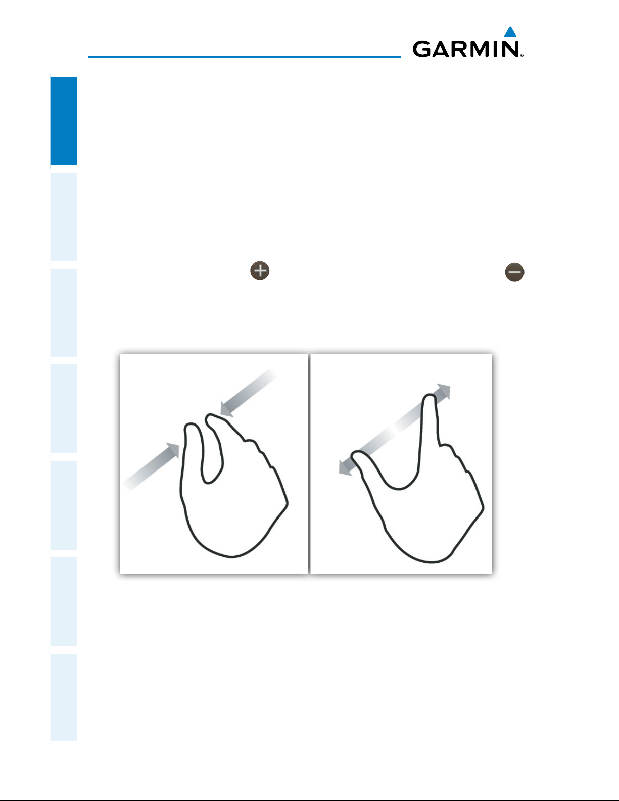
the finger across the display and you can magnify or zoom by double-tapping the
display, by pinching, or use the button. Reversing your pinch or tapping the
will de-magnify or zoom out. Additionally, there is no Garmin Pilot input that requires
any specific weight or pressure on the display. In other words, tapping or pressing
forcefully on the glass will produce approximately the same result as a light tap.
Pinch Zoom
Page 21

Garmin Pilot for Android User’s Guide
190-01532-00 Rev. A
5
Overview
Overview Plan File Fly Subscriptions Appendices Index
Garmin Pilot can be used in either portrait or landscape orientation and will respond
to the Android's automatic orientation feature. The map may be displayed in either
full screen or split screen in either orientation. The lower half of the display in portrait
orientation or second (non-map) display in landscape orientation has four possible
functions; Panel, Widgets, Charts, or SafeTaxi.
• Panel Mode is customizable and can be configured to display an instrument panel
with virtual instruments to indicate GPS altitude, ground speed, vertical speed,
course, and lateral deviation as well as a table with up to 15 configurable data fields
for monitoring navigation data.
• Widget Mode enables a series of customizable data windows called ‘Widgets’ to
be displayed. Widgets offer quick access to a variety of aviation weather products
(METARs, TAFs, Winds Aloft, NOTAMs, etc…) for nearby or selected airports and can
also display up to 14 navigation parameters which are also configurable.
Charts, and SafeTaxi when viewed in split-screen, have the same function, navigation,
and capabilities as the full screen versions of these products, just displayed in half
screen.
Garmin Pilot requires a data connection for downloading maps and other data prior to
departure, but once you have downloaded everything needed for your flight, it is ready
to navigate. The Downloads Menu in the Garmin Pilot settings options will indicate
when new downloadable data products are available upon connection to the Internet
Page 22

Garmin Pilot for Android User’s Guide
190-01532-00 Rev. A
6
Overview
OverviewPlanFileFlySubscriptionsAppendicesIndex
GETTING STARTED
Garmin Pilot is fully functional immediately upon installation, but there are a few
things you may wish to set up in order to optimize performance right away. The
best place to start is with the highly intuitive Settings Menu, which can be found by
momentarily tapping the Home Button and then the Settings Icon. The Settings Menu
is always available from the Home Button.
Garmin Pilot Settings
Page 23
Garmin Pilot for Android User’s Guide
190-01532-00 Rev. A
7
Overview
Overview Plan File Fly Subscriptions Appendices Index
From the Settings Menu it is possible to set up or change the time format, show/hide
features like the Navigation Bar (on the map display) or input pilot profile and aircraft
information, manage user waypoints, set up your preferred flight plan filing service,
manage your data subscriptions and much more. All of these and more selections are
available by tapping the tab associated with the desired function.
To further enhance your Garmin Pilot experience, it is recommended that you set
up a free flyGarmin account at http://fly.garmin.com. Aside from being completely
free, flyGarmin offers a great one-stop shop for managing all of your Garmin aviation
equipment, as well as storing your pilot profile and aircraft information. From aviation
database bundles to software updates for portables to flight planning, flyGarmin has
you covered.
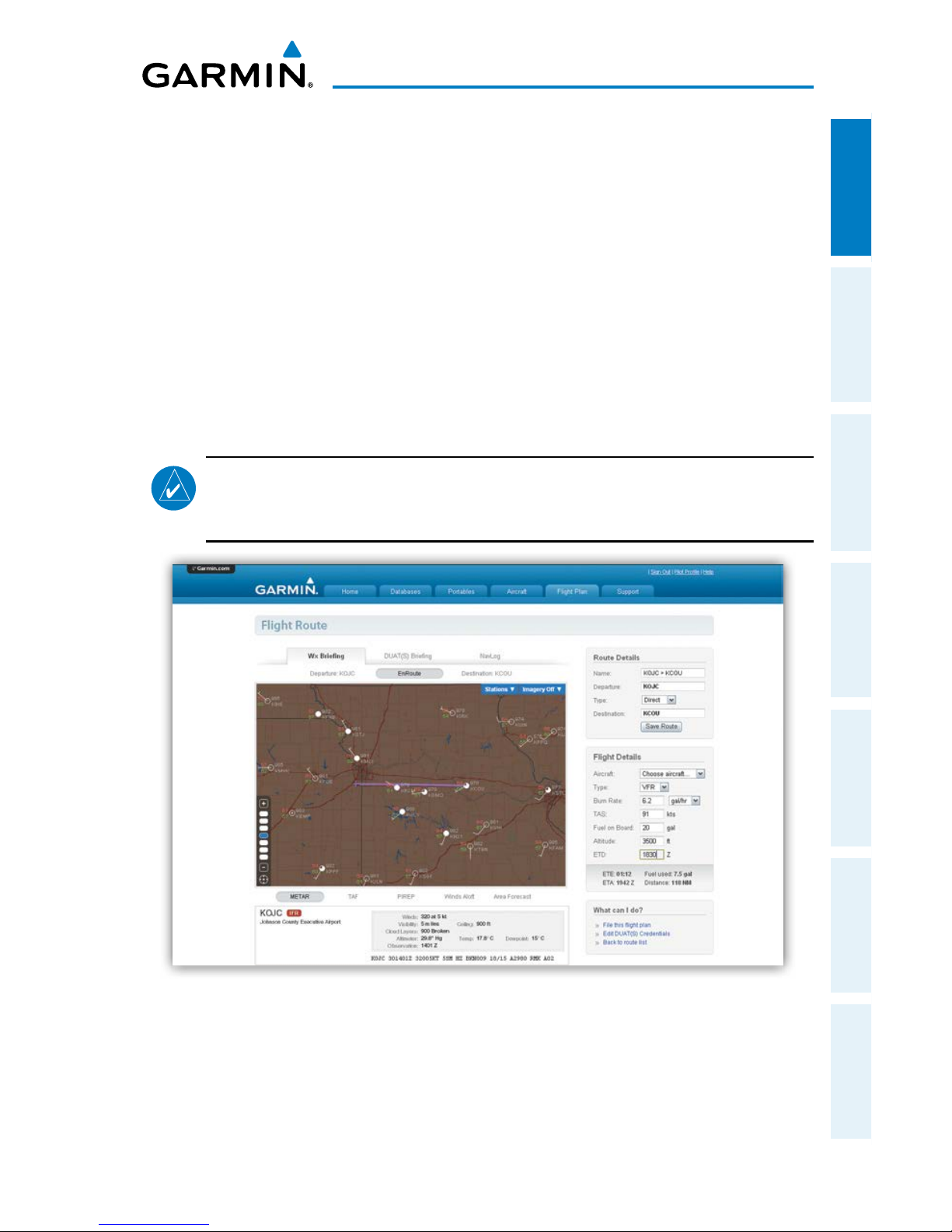
NOTE:
flyGarmin and Garmin Pilot Username and Passwords can be
different. Ensure you are using the correct information when logging into
flyGarmin or Garmin Pilot.
flyGarmin
Page 24
Garmin Pilot for Android User’s Guide
190-01532-00 Rev. A
8
Overview
OverviewPlanFileFlySubscriptionsAppendicesIndex
HELP FILE
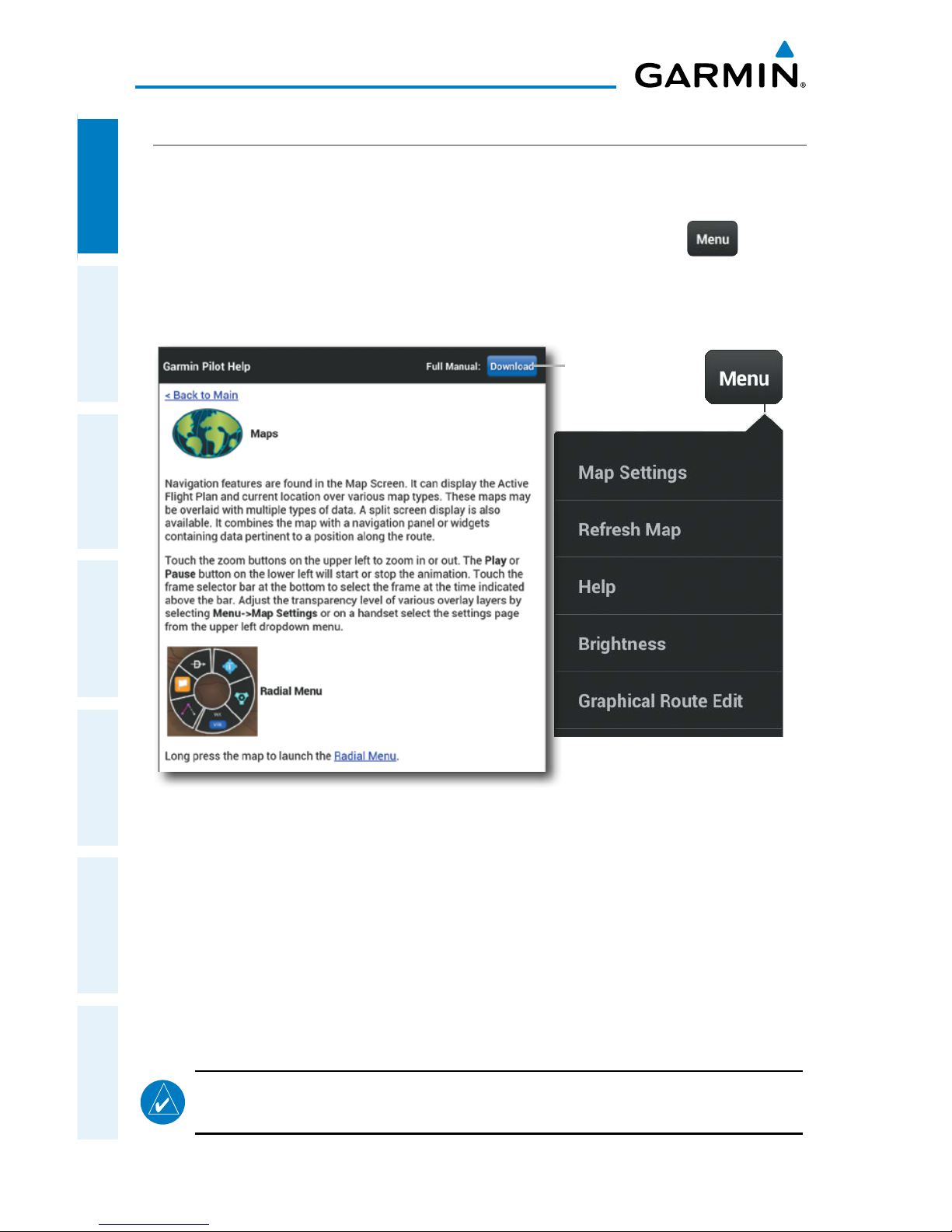
The content of the User's Guide is mirrored in the in app help file providing context
sensitive instructions for getting the most out of you Garmin Pilot subscription. The
help file can be accessed from any page by tapping the Menu Button( ) located
in the Navigation Bar and then tapping 'Help' in the page sensitive menu. Navigating
within the Help File is as easy as tapping any of the hyperlinks.
Help File
Map Page Menu
Tap to
Download
the Full Help
Manual
Accessing the Help File:
Tap Menu > Help. The Help File will open to context sensitive content
USER'S GUIDE
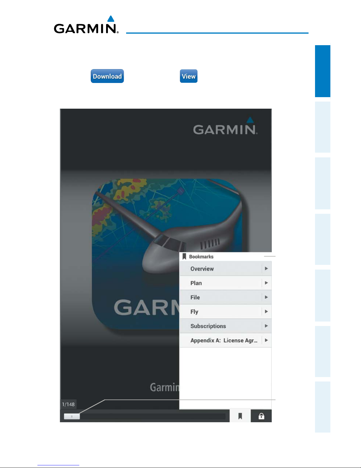
The Full Manual is the PDF formatted User's Guide for Garmin Pilot. The first time
the file is accessed you will be prompted to chose a default PDF viewer. The Full
Manual has a linked table of contents, index, and Bookmarks for easy navigation.
NOTE:
The Full Manual will open to the most recently accessed page. User
the Bookmarks or Page Slider to quickly navigate the file.
Page 25
Garmin Pilot for Android User’s Guide
190-01532-00 Rev. A
9
Overview
Overview Plan File Fly Subscriptions Appendices Index
Accessing the Full Manual:
1)
Tap Menu > Help.
2)
Tap to download, tap , to view the manual once
downloaded. Anytime an updated manual is available the View button will
revert to a Download button.
Full Manual
Bookmarks
Page
Slider
Page 26
Garmin Pilot for Android User’s Guide
190-01532-00 Rev. A
10
Overview
OverviewPlanFileFlySubscriptionsAppendicesIndex
NAVIGATION BAR
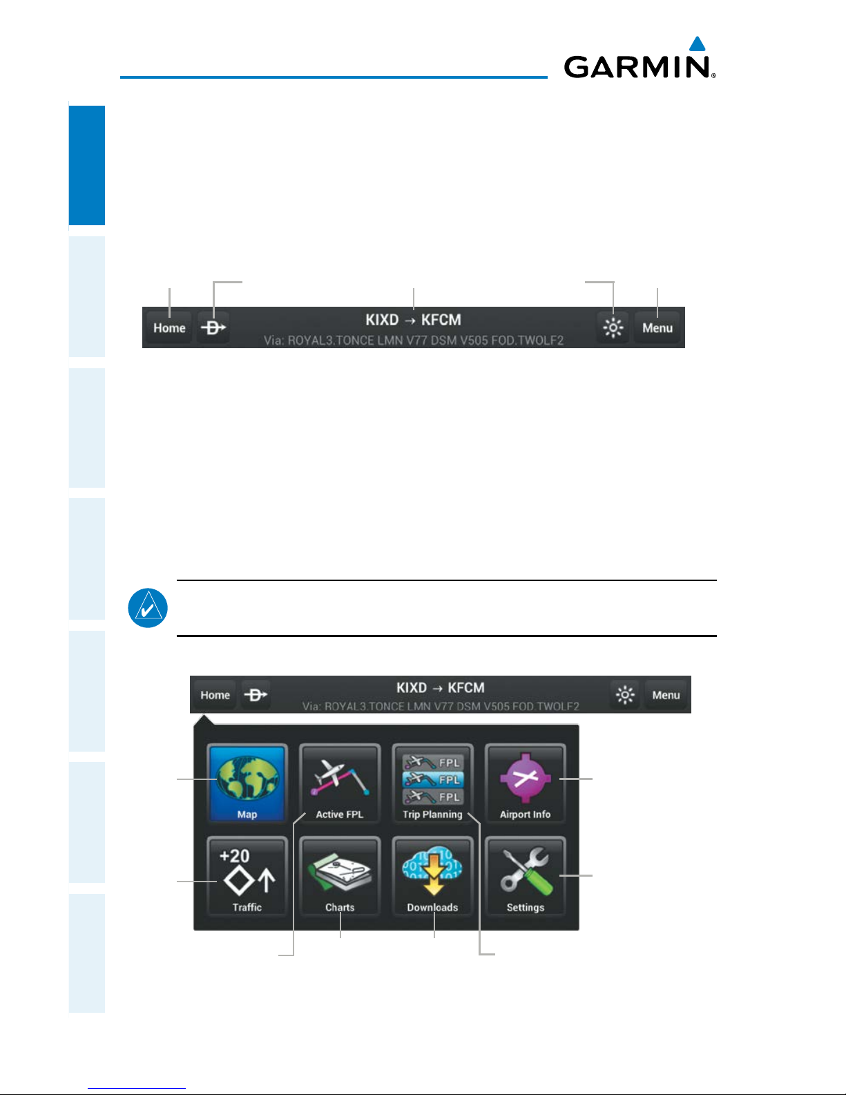
Garmin Pilot's user interface is comprised of icons and active areas that provide
access to the various features and functions of the application. The Navigation Bar,
located at the top of every page, provides access to many of the basic functions.
Navigation Bar
Home
Button
Direct-to Brightness Button
Page
Sensitive
Menu Button
Active
Flight Plan
HOME BUTTON
The Home Button is the primary means of accessing many of the features of Garmin
Pilot. The Home Button provides quick access to the various pages within Garmin Pilot
(i.e., Map, Active Flight Plan, Trip Planning, Airport Information, Charts, Downloads,
Settings, and Traffic).
NOTE:
The Traffic Button will only be available after connecting to a GDL 39
and will remain present even if you are not currently connected to a GDL 39.
Map
Button
Charts
Button
Active Flight
Plan Button
Downloads
Button
Trip Planning
Button
Airport
Information
Button
Home Menu
Traffic
Button
Settings
Button
Page 27
Garmin Pilot for Android User’s Guide
190-01532-00 Rev. A
11
Overview
Overview Plan File Fly Subscriptions Appendices Index
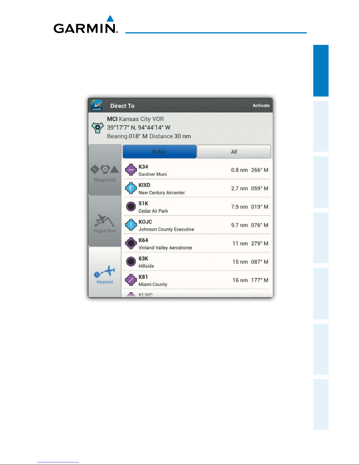
DIRECT-TO
The Direct-to button can be accessed from any page and provides a quick and easy
way to navigate direct to any waypoint (i.e., Flight Plan Waypoint, Nearest Waypoints,
or User Waypoints).
Direct-to Dialog
Page 28
Garmin Pilot for Android User’s Guide
190-01532-00 Rev. A
12
Overview
OverviewPlanFileFlySubscriptionsAppendicesIndex
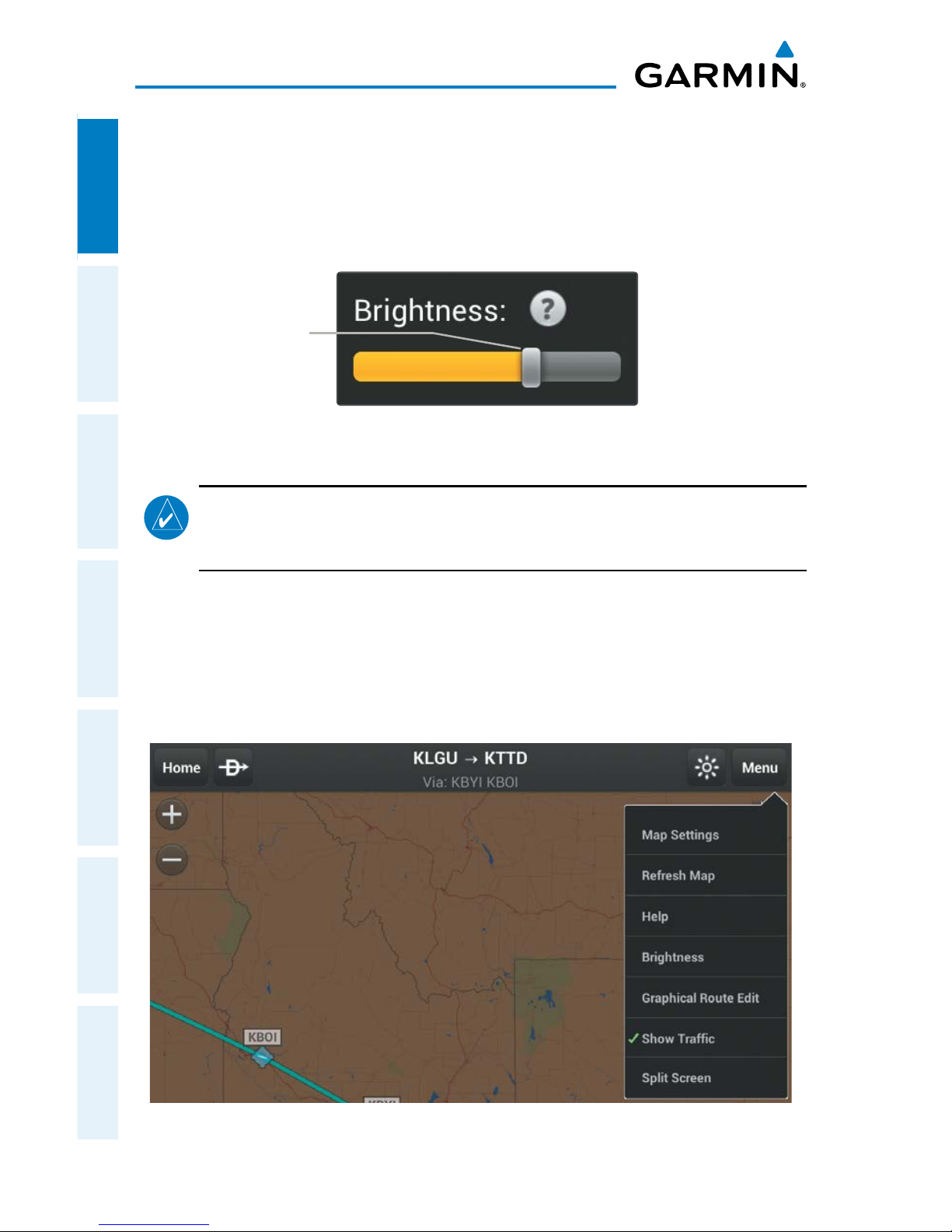
BRIGHTNESS
The Brightness Button provides access to the display brightness control. Simply tap
the icon to display a display brightness slider and set the desired display brightness.
Move the slider to the right to increase display brightness or left to decrease brightness.
Brightness Slider
Brightness Slider
NOTE:
To enable the in application brightness settings some Android devices
may require disabling the "Automatic brightness" setting for the system
brightness.
MENU
The Menu Button provides a page-sensitive menu structure. Each page has specific
menu options that control, search, navigate, or display page-sensitive items.
Map Page Menu
Page 29
Garmin Pilot for Android User’s Guide
190-01532-00 Rev. A
13
Overview
Overview Plan File Fly Subscriptions Appendices Index
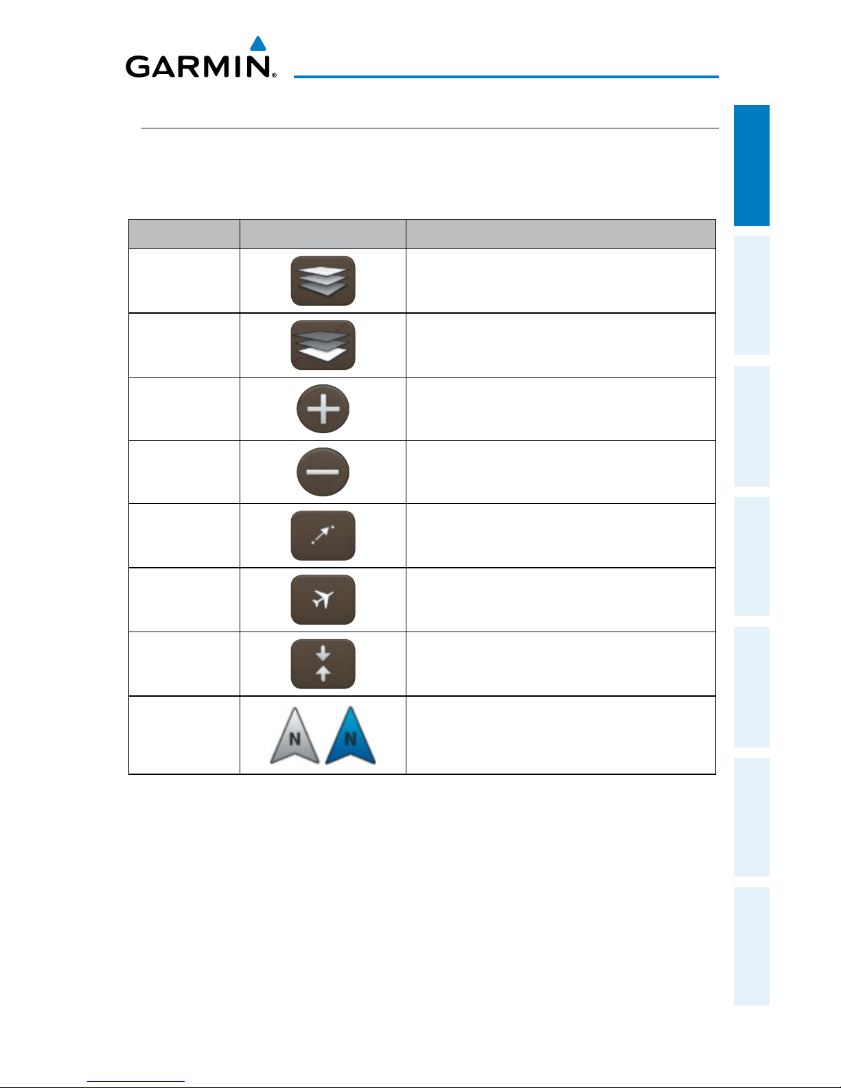
MAP PANE CONTROLS
The Map Pane has a number of buttons that control the Base Map, Map Overlays
and center map and split-screen. The table below shows the Map Pane Controls.
Control Icon Description
Layer Select
Opens Map Overlay menu
Basemap
Select
Opens Basemap selection menu
Zoom In
Zooms In on the map
Zoom Out
Zooms out on the map
Center on
Route
Centers the entire route in Map Pane.
Center on
Aircraft
Centers the Map Pane on the current
location.
Split-Screen
Selects full screen map or partial map with
Widgets, Panel, Charts, and SafeTaxi.
Map
Orientation
Toggles map orientation from north up to
track up. The Icon is blue when track up is
active.
Map Pane Controls
Page 30
Garmin Pilot for Android User’s Guide
190-01532-00 Rev. A
14
Overview
OverviewPlanFileFlySubscriptionsAppendicesIndex
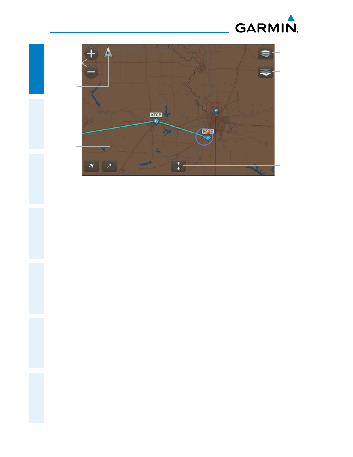
Map Pane
SplitScreen
Layer
Select
Center on
Aircraft
Center
on Route
Zoom
In/Out
Basemap
Select
Map
Orientation
Page 31
Garmin Pilot for Android User’s Guide
190-01532-00 Rev. A
15
Overview
Overview Plan File Fly Subscriptions Appendices Index
SETTINGS
Located under the Home Button, tap the Settings Icon to open the Settings Menu.
The Settings Menu tabs customize and manage Garmin Pilot features, subscriptions,
Pilot Info, Aircraft Info and much more.
SUPPORT & ABOUT
More information is available under the Support & About button. Tap the Support
& About Tab to display the current version of the Garmin Pilot Application installed
on your device, copyright information, and contact information (both email and
phone) for Garmin Aviation Support. Tap the email address to compose an email and
send it directly to Garmin Aviation Support. Sending a support email in this manner
will automatically populate the email with information that will greatly aid us in
troubleshooting and resolving any issues you may have.
NOTE:
A data connection (i.e., Wi-Fi or cellular) is required to send and receive
email.
Tap 'What's new in...' link to view information about what's new in the latest
Garmin Pilot update.
GENERAL SETTINGS
General Settings tab provides access to Automatic SafeTaxi settings. When 'Auto
Start SafeTaxi' is on, SafeTaxi will launch after landing at the destination airport when
ground speed drops below 40 kts.
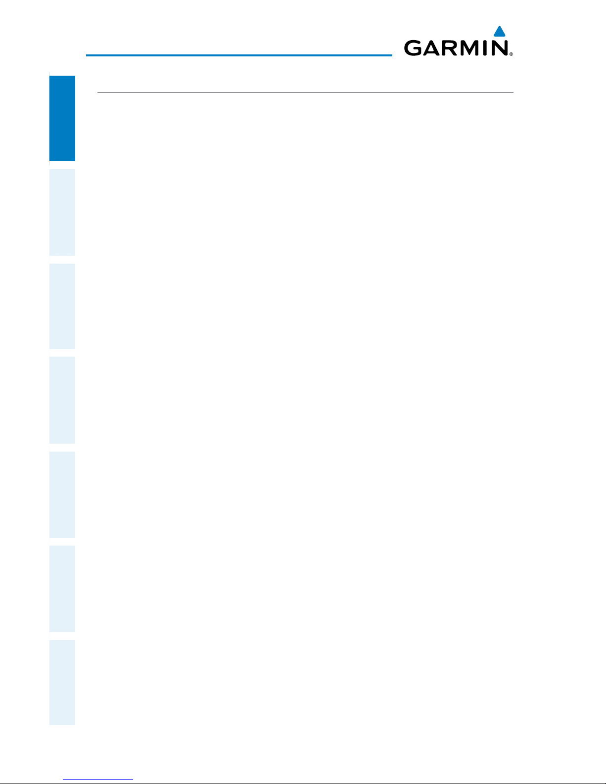
AIRCRAFT SYMBOL
The Aircraft Symbol is displayed on maps, Geo-referenced FliteCharts, and SafeTaxi
diagrams when the application senses movement, otherwise the blue system location
symbol is used.
Aircraft Symbol System Location Symbol
Page 32
Garmin Pilot for Android User’s Guide
190-01532-00 Rev. A
16
Overview
OverviewPlanFileFlySubscriptionsAppendicesIndex
MAP SETTINGS
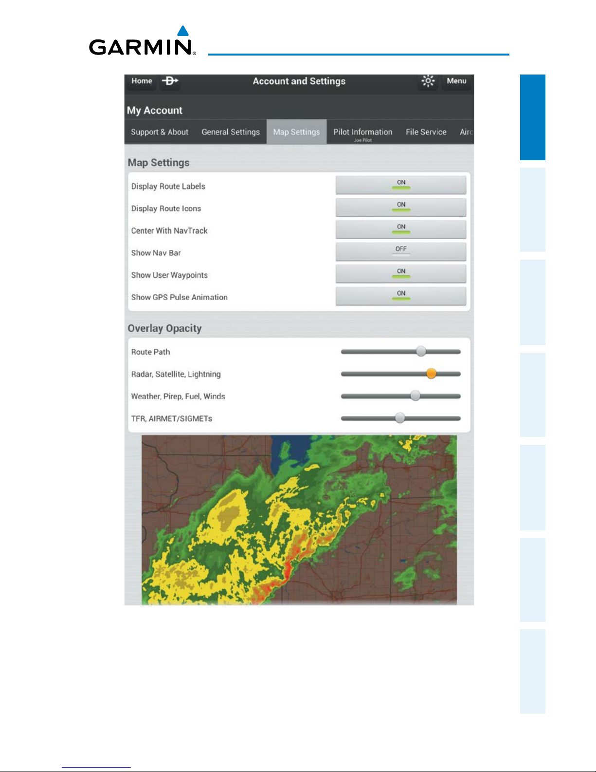
The Map Settings tab provides setting for Route symbols and Overlay Opacity. The
General Map Settings are on/off buttons, that control the display of flight plan symbols,
navigation information (Nav Bar), and Users Waypoints. The Overlay Opacity settings
control the opacity of the Route Path, Radar, Satellite, Lightning, Weather, Pirep, Fuel,
Winds, TFR, and AIRMET/SIGMETs. Use the preview map, below the opacity sliders, to set
the desired opacity for the various map symbols and overlays.
Page 33
Garmin Pilot for Android User’s Guide
190-01532-00 Rev. A
17
Overview
Overview Plan File Fly Subscriptions Appendices Index
Map Settings
Page 34
Garmin Pilot for Android User’s Guide
190-01532-00 Rev. A
18
Overview
OverviewPlanFileFlySubscriptionsAppendicesIndex
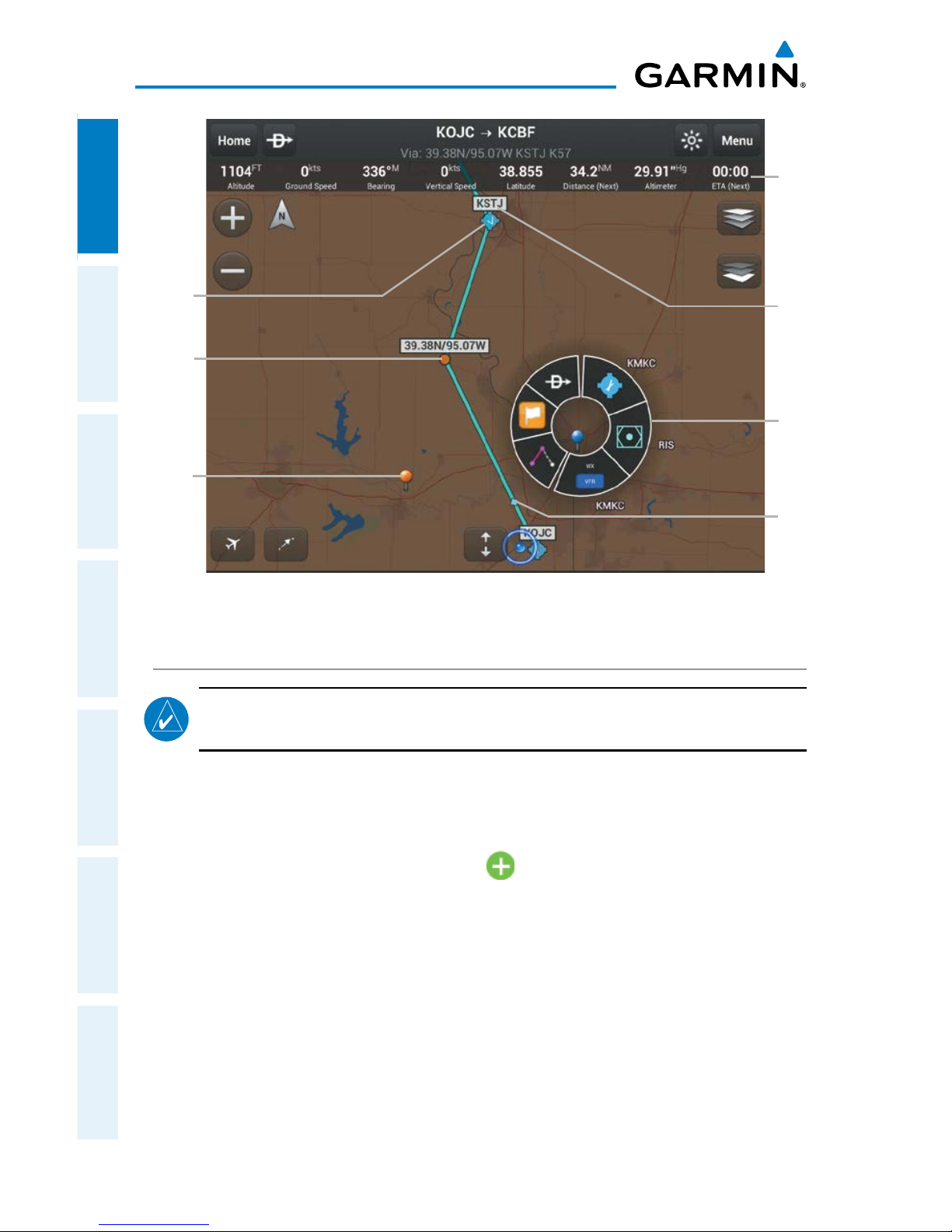
Route
Label
Route
Icon
WX
Station
Pin
NavTrack
Position
Radial
Menu
Flight Plan Symbols
User
Waypoint
Nav
Bar
PILOT AND AIRCRAFT INFO
NOTE:
A data connection (i.e., Wi-Fi or cellular) is required to file flight plans.
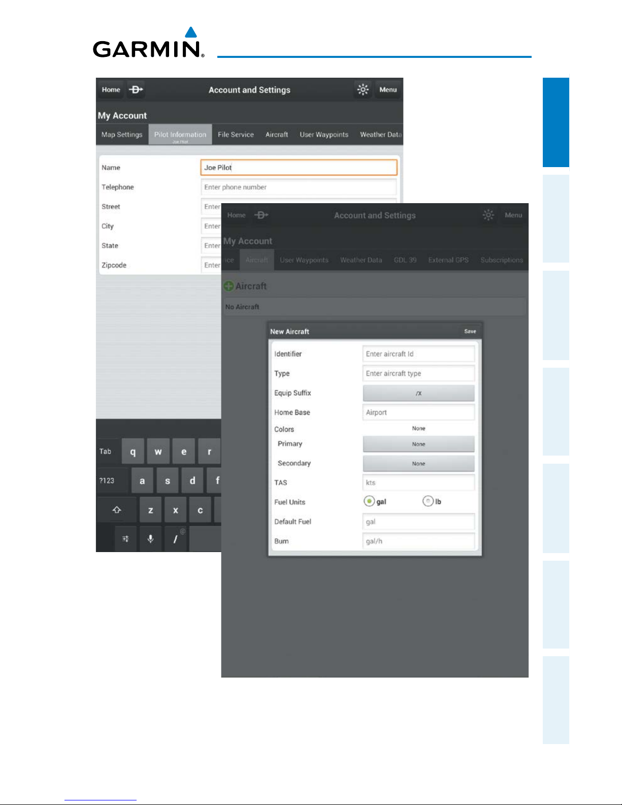
If you already have a flyGarmin.com account, simply tap Menu > Sync to synchronize
your Pilot and Aircraft information. Tap in each field and use the on-screen keyboard
to enter your information (i.e., Name, Telephone, Street, City, State, and Zipcode). Add
aircraft information by tapping Aircraft > , enter aircraft Identifier, Type, Equip
Suffix, Home Base, Primary and Secondary Color, TAS, and Fuel information.
Page 35
Garmin Pilot for Android User’s Guide
190-01532-00 Rev. A
19
Overview
Overview Plan File Fly Subscriptions Appendices Index
Pilot and Aircraft Information Entry
Page 36
Garmin Pilot for Android User’s Guide
190-01532-00 Rev. A
20
Overview
OverviewPlanFileFlySubscriptionsAppendicesIndex
Entering Pilot Information:
1)
From any page tap > .
2)
Tap Pilot Information.
3)
Enter the Pilot Information by tapping each field and use the keyboard.
Or:
If pilot information is stored on another device log into your Garmin Pilot
account.
Tap Menu > Sync, to synchronize information across your devices
.
Entering Aircraft Information:
1)
From any page tap > .
2)
Tap
Aircraft > .
3)
Enter the Required Aircraft Information by tapping each field and use the
keyboard.
4)
Tap Save, to save aircraft information.
Or:
If aircraft information is stored on another device log into your Garmin Pilot
account.
Tap Menu > Sync, to synchronize information across your devices
.
FILE SERVICE
To link Garmin Pilot with a Direct User Access Terminal Service (DUATS) account,
under the File Service Tab, enter username and password information for the preferred
DUATS provider. By linking to a DUATS account, Garmin Pilot can file flight plans.
Garmin Pilot is compatible with both Data Transformation Corp. (DTC) or Computer
Sciences Corporation (CSC) Direct User Access Terminal Service (DUATS) services.
Linking File Service:
1)
From any page tap > .
2)
Tap File Service.
3)
Select the Preferred Provider.
4)
Enter the Preferred DUATS Provider credentials (DTC or CSC).
Or:
If provider credentials are stored on another device log into your Garmin
Pilot account.
Tap Menu > Sync, to synchronize information across your
devices
.
Page 37
Garmin Pilot for Android User’s Guide
190-01532-00 Rev. A
21
Overview
Overview Plan File Fly Subscriptions Appendices Index
USER WAYPOINTS
The User Waypoints Tab provides a quick and easy way to create and view stored
user waypoints.
Creating a User Waypoint from User Waypoint Tab:
1)
Tap the User Waypoint Tab to display the list of user waypoints
.
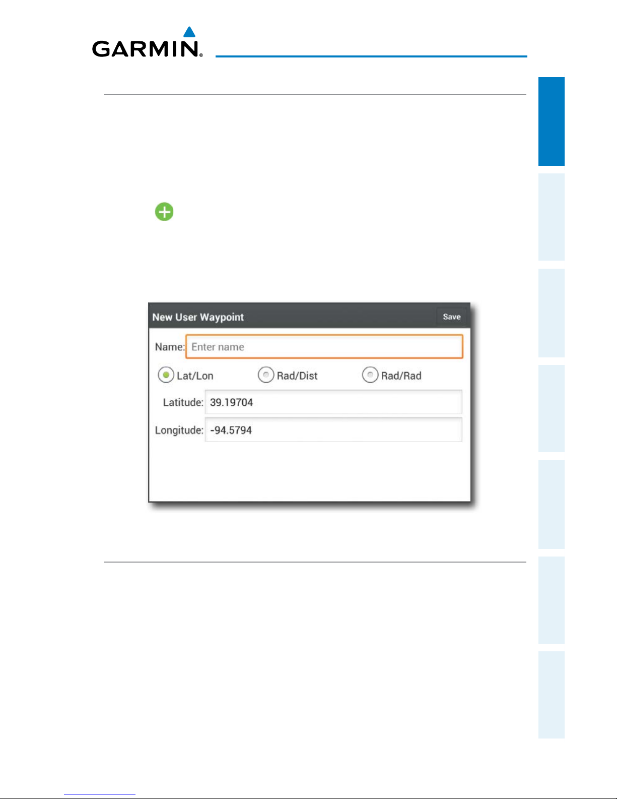
2) Tap button to display the 'New User Waypoint' dialog box.
3) Enter a name.
4) Define the waypoint location by Lat/Lon, Rad/Dist, or Rad/Rad.
5) Tap Save, to save the waypoint, or Back to exit.
New User Waypoint Dialog
WEATHER DATA
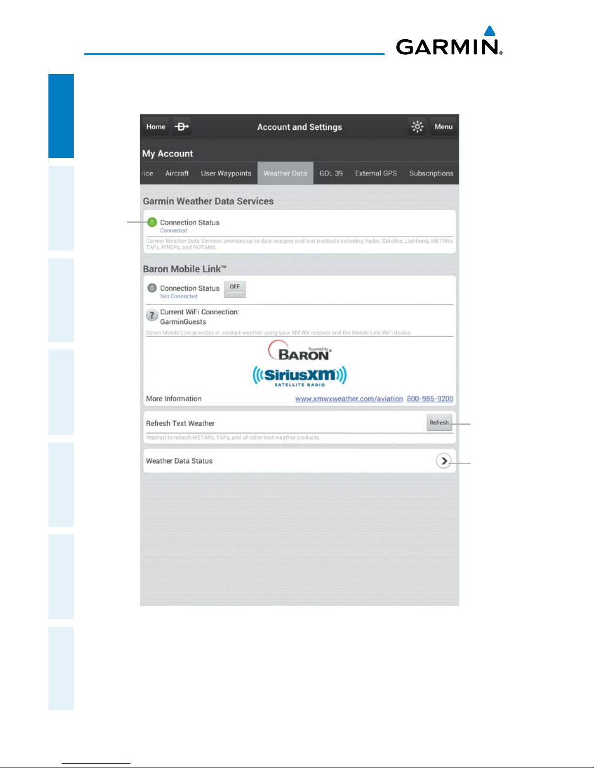
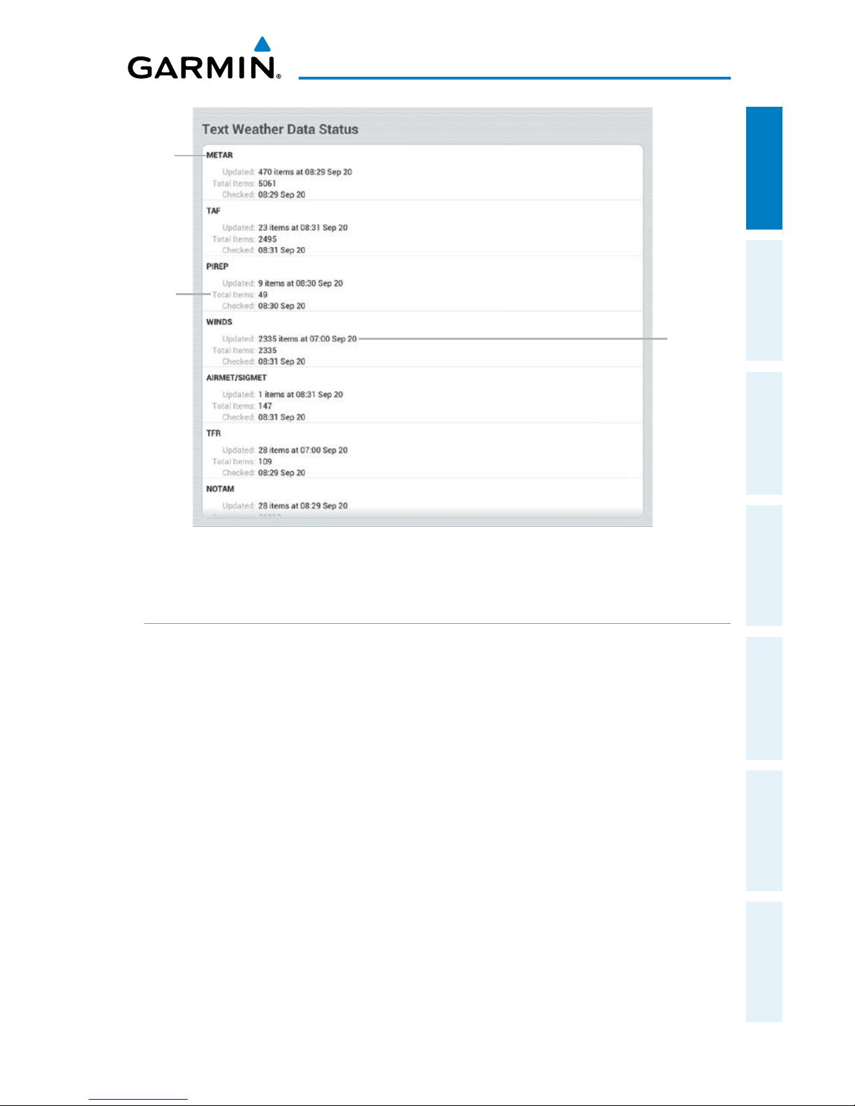
The Weather Data Tab provides information about the current source of weather
data and the age of Garmin Weather Data items cached on the device. The age and
status of weather data for FIS-B-sourced weather is viewable under the GDL 39 Tab.
Weather data is available from three sources, Garmin Weather Data Services, FIS-B
weather via a GDL 39 or SiriusXM Weather via a Baron Mobile Link™. Garmin
Weather Data Services requires a data connection through Wi-Fi or cellular network.
Baron Mobile Link™ weather, and FIS-B weather, require additional hardware. Baron
Mobile Link also requires a subscription to SiriusXM Weather.
Page 38
Garmin Pilot for Android User’s Guide
190-01532-00 Rev. A
22
Overview
OverviewPlanFileFlySubscriptionsAppendicesIndex
Weather Data Services
Weather
Connection
Status
Tap to
refresh
cached
weather
data
Tap to
view
weather
data status
Page 39
Garmin Pilot for Android User’s Guide
190-01532-00 Rev. A
23
Overview
Overview Plan File Fly Subscriptions Appendices Index
Weather Data Status
Weather
Product
Total
Product
Item
Cached
Number
of Items
Updated
and
Update
Time
GDL 39
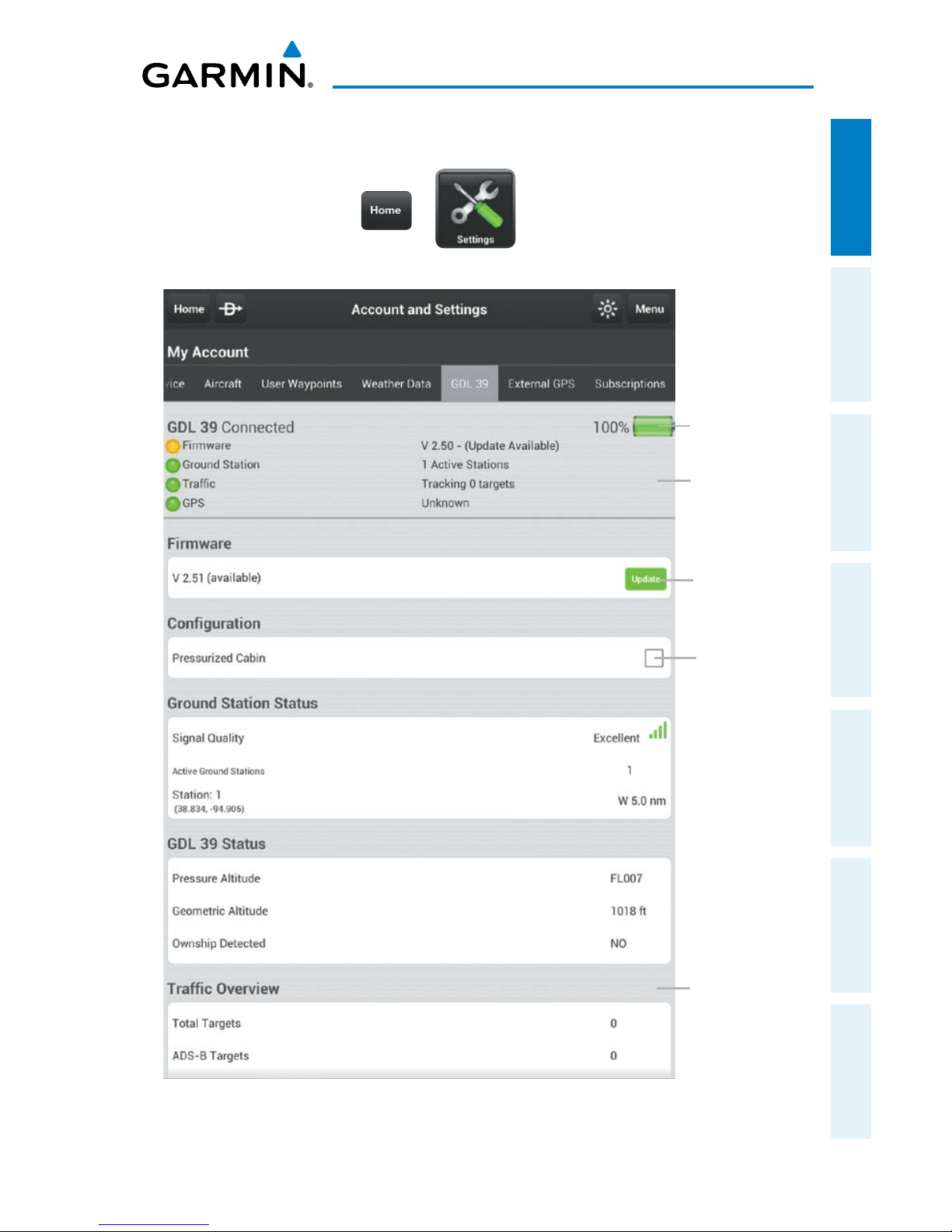
The GDL 39 is a Bluetooth® enabled receive-only data link radio with on-board
GPS, 978 MHz (Universal Access Transceiver frequency band), and 1090 MHz Extended
Squitter (1090 ES) receivers. It is designed to receive, process, and output traffic
(ADS-B air-to-air, and Traffic Information Service-Broadcast (TIS-B) traffic information),
and weather (Flight Information Service-Broadcast (FIS-B)) information to Garmin
Pilot wirelessly through Bluetooth®. The GDL 39 Tab displays the GDL 39 Bluetooth
connection status, GDL 39 firmware version, Ground Station Status, Pressure and
Geometric Altitude as well as Traffic and Weather information. The Traffic Overview
includes the number and source (i.e., ADS-B air-to-air, or (TIS-B)) of traffic the GDL 39
is currently tracking. The Weather information provides the age of weather products
received through FIS-B. The GDL 39 also has a pressure altitude sensor to aide in
displaying the relative altitude of received traffic information. If the GDL 39 is used
onboard a pressurized aircraft the pressure altitude sensor should be turned off to
prevent false readings.
Page 40
Garmin Pilot for Android User’s Guide
190-01532-00 Rev. A
24
Overview
OverviewPlanFileFlySubscriptionsAppendicesIndex
Configuring the GDL 39 for a Pressurized or Non-Pressurized
Aircraft:
1)
From any page tap > .
2)
Tap the GDL 39 Tab.
3)
Tap Pressurized Cabin to select/deselect.
Updating GDL 39 Firmware:
1)
Ensure the tablet and the GDL 39 are connected to a reliable external
power source.
2)
From any page tap > .
3)
Tap the GDL 39 Tab.
4)
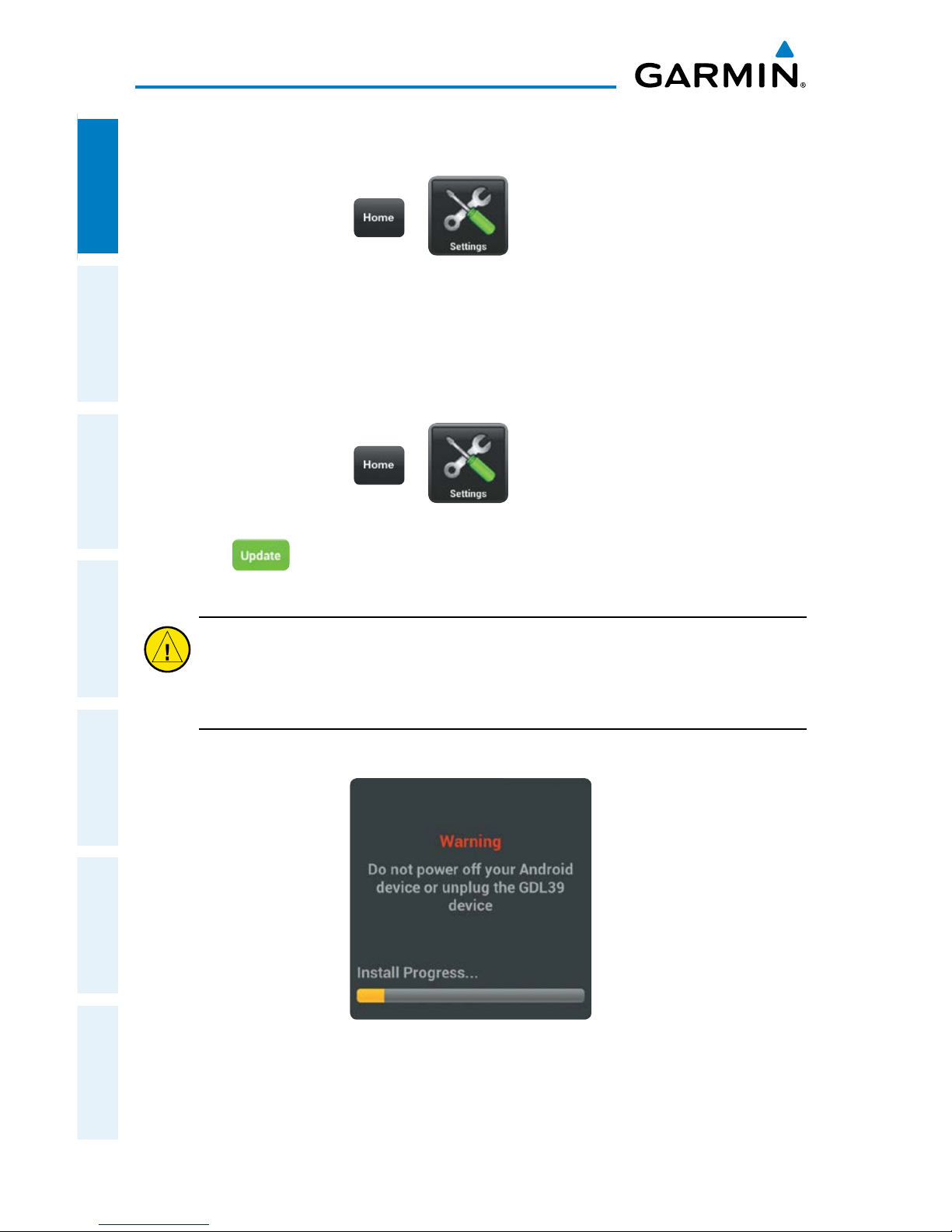
Tap . The 'Update' button is only displayed when an update is
available.
Caution:
Never remove power from the GDL 39 or power off the Android
device during a GDL 39 firmware update. If power is removed from the GDL
39 during a firmware update it will be rendered inoperable and service will
be required.
GDL 39 Firmware Warning
Page 41
Garmin Pilot for Android User’s Guide
190-01532-00 Rev. A
25
Overview
Overview Plan File Fly Subscriptions Appendices Index
Viewing GDL 39 Status (including Ground Stations, Traffic, and
Weather):
1)
From any page tap > .
2)
Tap the GDL 39 Tab.
GDL 39 Tab
Scroll down
to view Traffic
Overview, and
FIS-B Weather
Status and Age
GDL 39
Status
GDL 39
Battery
Status
Cabin
Pressure
Config
Tap to
Update GDL
Firmware
Page 42
Garmin Pilot for Android User’s Guide
190-01532-00 Rev. A
26
Overview
OverviewPlanFileFlySubscriptionsAppendicesIndex
EXTERNAL GPS
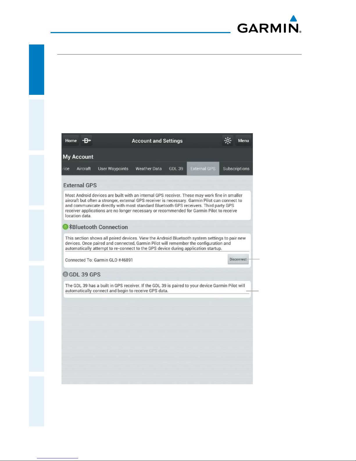
Most Android devices are built with an internal GPS receiver. These may work fine in
smaller aircraft but often a stronger, external GPS receiver is necessary. If your Android
device does not include a GPS receiver, a Garmin GLO™ portable GPS and GLONASS
receiver, or a Garmin GDL 39 portable GPS and ADS-B receiver will be required to
take advantage of the navigation features of Garmin Pilot. Third party GPS receiver
applications are no longer recommended for Garmin Pilot to receive location data.
External GPS Tab
GDL
39 GPS
Status.
Tap to
Connect or
Disconnect
External
GPS Source
Page 43
Garmin Pilot for Android User’s Guide
190-01532-00 Rev. A
27
Overview
Overview Plan File Fly Subscriptions Appendices Index
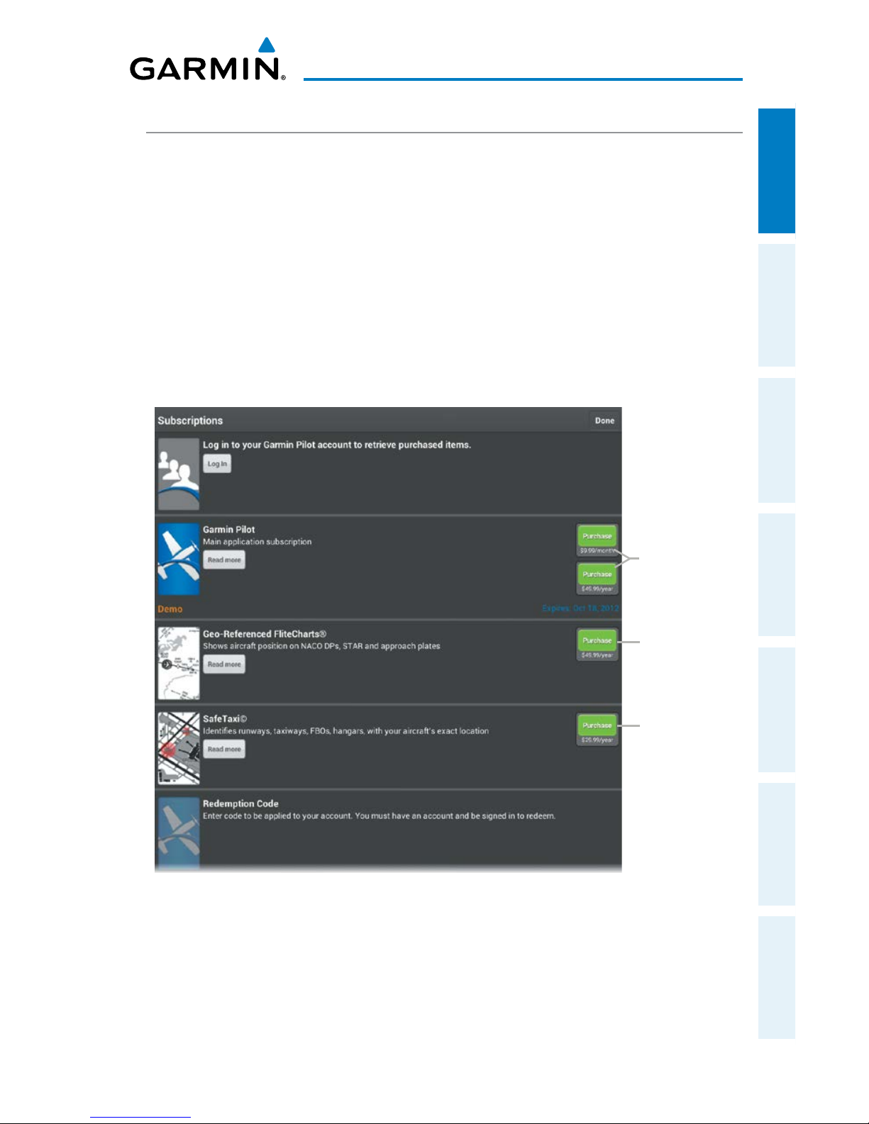
SUBSCRIPTIONS
The Subscriptions Tab provides information about the status of any subscription
associated with your Garmin Pilot Account and the ability to purchase annual or monthly
subscriptions or renew expired subscriptions. Tap the green icon associated with the
desired subscription and enter your Google credentials. The subscription fee will be
charged to your Google play account. If you already have Garmin Pilot subscriptions,
log in to your Garmin Pilot account to view subscriptions, expiration dates, as well as
share routes, aircraft, and pilot information. With an active subscription Garmin Pilot
can be installed on up to two devices at the same time, typically a mobile phone and
a tablet device.
Subscriptions
Tap to
Add GeoReferenced
FliteCharts
®
Tap to
Purchase
a Monthly
or Annual
Subscription
Tap to Add
SafeTaxi
®
Page 44
Garmin Pilot for Android User’s Guide
190-01532-00 Rev. A
28
Overview
OverviewPlanFileFlySubscriptionsAppendicesIndex
DOWNLOADS
NOTE:
If charts are not downloaded to the device they will not be available for
viewing without a data connection. Download all applicable charts for your
planned flight including alternates.
NOTE:
Chart files can be very large and may take some time to download. It
is recommended that downloads be done over Wi-Fi. Additional charges may
apply for downloads done over a cellular network.
NOTE:
With the availability of electronic charts in Garmin Pilot, it is still
advisable to carry another source of charts on board the aircraft.
The Downloads Menu is divided into two sections. The Navigation & Airports section
allows for downloading US Navigation Data, Airport Info, and SafeTaxi information.
The Procedures & Charts section allows for downloading VFR Sectional Charts,
WAC Charts, IFR Low and High Altitude Charts, and Instrument Procedures for the
Continental US as well as Alaska and Hawaii.
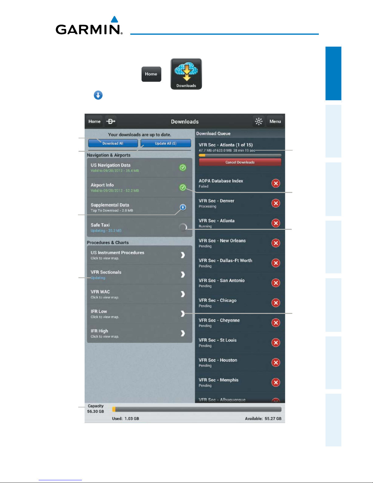
The Downloads Menu is divided into two columns. The Left column shows items
available for download as indicated by the blue down arrows ( ) or blue text. The
right column is the Download Queue, shows the download status and a list of queued
downloads.
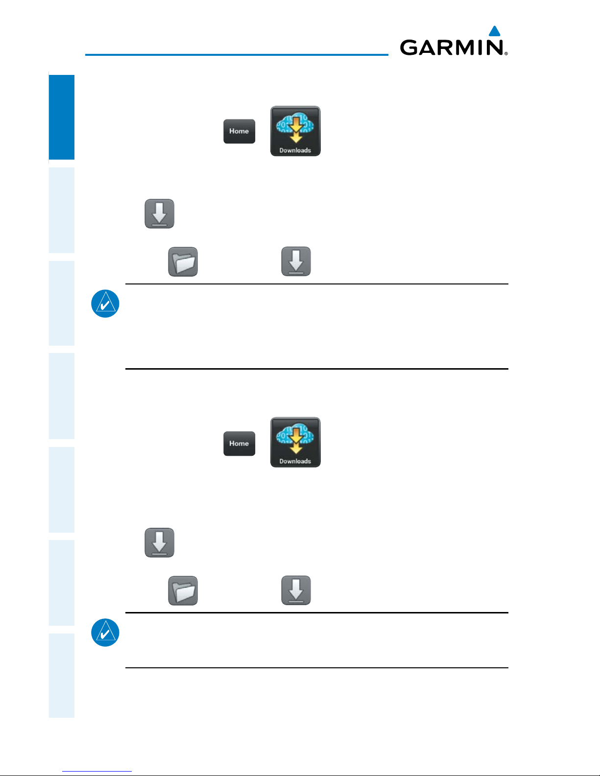
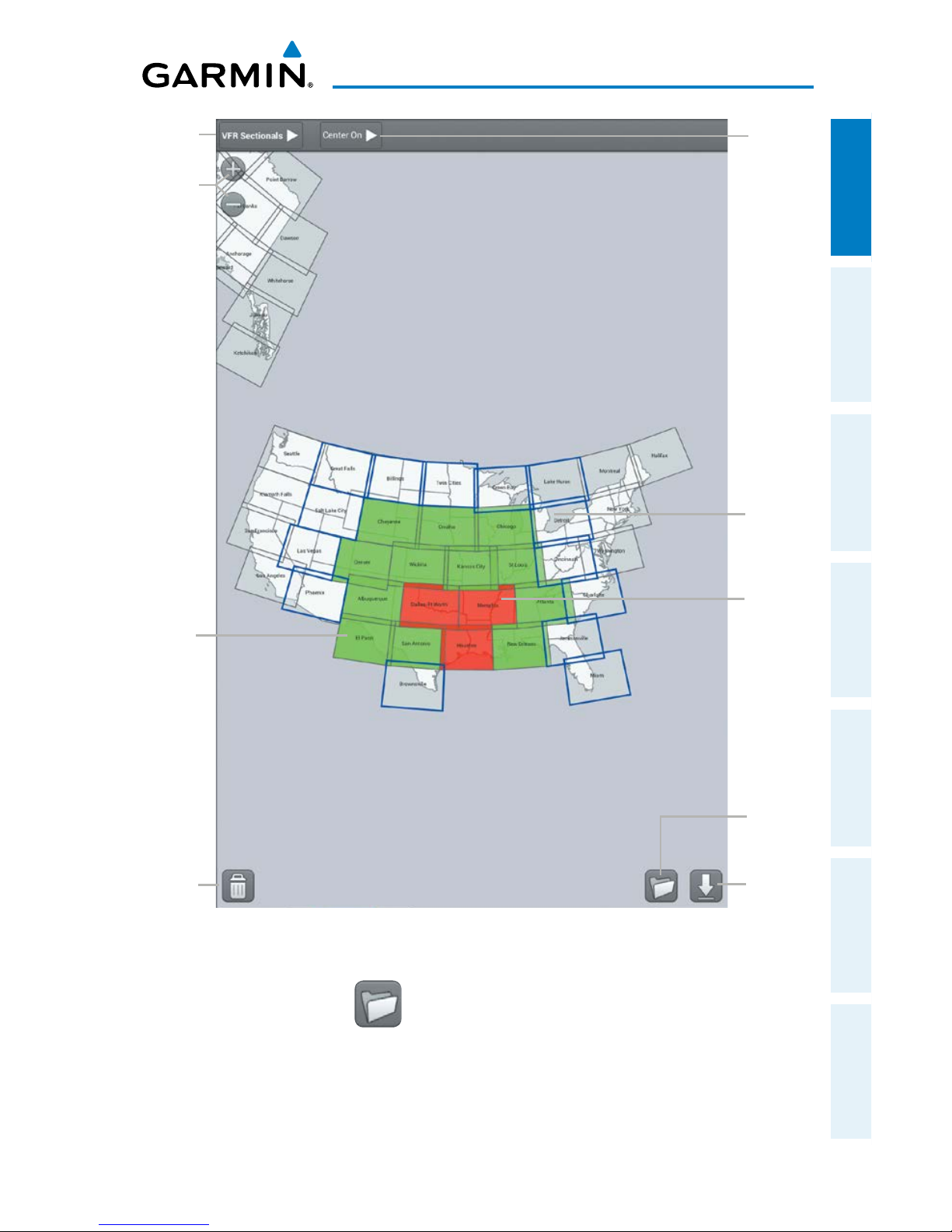
The submenus for VFR Sectional Charts, WAC Charts and IFR Low and High Altitude
Charts display the Chart Selection Screen, which is a map showing the charts as
outlined areas. To select all available charts tap the file folder in the lower left corner
and tap 'Select All' from the list or tap the outlined area for the desired chart(s). After
selecting the chart(s) to download tap the Download Arrow in the lower right corner.
Terminal Procedure charts can be viewed and downloaded from the Airport Info Page,
under the Procedures tab as well.
NOTE:
A data connection (i.e., Wi-Fi or cellular) is required to download or
update charts.
Page 45
Garmin Pilot for Android User’s Guide
190-01532-00 Rev. A
29
Overview
Overview Plan File Fly Subscriptions Appendices Index
Downloading US Navigation Data, Airport Info or SafeTaxi:
1)
From any page tap > .
2)
Tap to begin downloading the desired information.
Downloads Page
More
info in
Submenu
Update
Status
Update in
Progress
Queued
Downloads
Status and
Estimated
Time
Remaining
Download
All Button
Update
All Button
Data is
Up to Date
Data
Available
Device
Capacity
Info
Page 46
Garmin Pilot for Android User’s Guide
190-01532-00 Rev. A
30
Overview
OverviewPlanFileFlySubscriptionsAppendicesIndex
Downloading Sectional, WAC, IFR Low Altitude, or IFR High
Altitude Charts:
1)
From any page tap > .
2) From the 'Procedures & Charts' list select the submenu for the desired chart.
3) Tap the outlined area on the Chart Selection Screen for the desired chart(s).
4) Tap to download the selected chart(s). The download will begin immediately
as shown in the Download Queue.
Or
: Tap
> Select All > , to download all available charts.
NOTE: When the next cycle of a chart is available a dialog box will appear, select the
desired cycle. WAC and Sectional Charts are updated individually on the chart schedule
and are available for download, typically 5 days prior to their valid date. IFR Low and High
Altitude Charts are updated on a 28-day cycle and are available for download typically 5
days prior to their valid date.
Downloading Instrument Procedures:
1)
From any page tap > .
2)
From the 'Procedures & Charts' list select the submenu for 'US Instrument
Procedures'.
3) Tap the State on the Chart Selection Screen for the desired chart(s).
4) Tap to download the selected chart(s). The download will begin immediately
as shown in the Download Queue.
Or
: Tap
> Select All > , to download all available charts.
NOTE: When the next cycle of a chart is available a dialog box will appear, select the
desired cycle. US Instrument Procedures are updated on a 28-day cycle and are available
for download typically 5 days prior to their valid date.
Page 47
Garmin Pilot for Android User’s Guide
190-01532-00 Rev. A
31
Overview
Overview Plan File Fly Subscriptions Appendices Index
Chart Selection Screen
Batch
Options
Button
Download
Button
Chart
Selected for
Download
Delete
Button
Chart is
Onboard
and Up-
to-date
Expired
Chart
Zoom
In/Out
Center
Map On
Data
Selection
BATCH OPTIONS
The Batch Options Button provides quick access to batch operations including; Update
Expired, Delete Expired, Delete All, Cancel Active Downloads, Reset Selection and
Select All.
Page 48
Garmin Pilot for Android User’s Guide
190-01532-00 Rev. A
32
Overview
OverviewPlanFileFlySubscriptionsAppendicesIndex
CHART UPDATES
NOTE:
Electronic Charts are updated frequently. Always ensure that the charts
saved to the device are up-to-date prior to each flight. With the availability of
electronic charts, it is still advisable to carry another source of charts onboard
the aircraft.
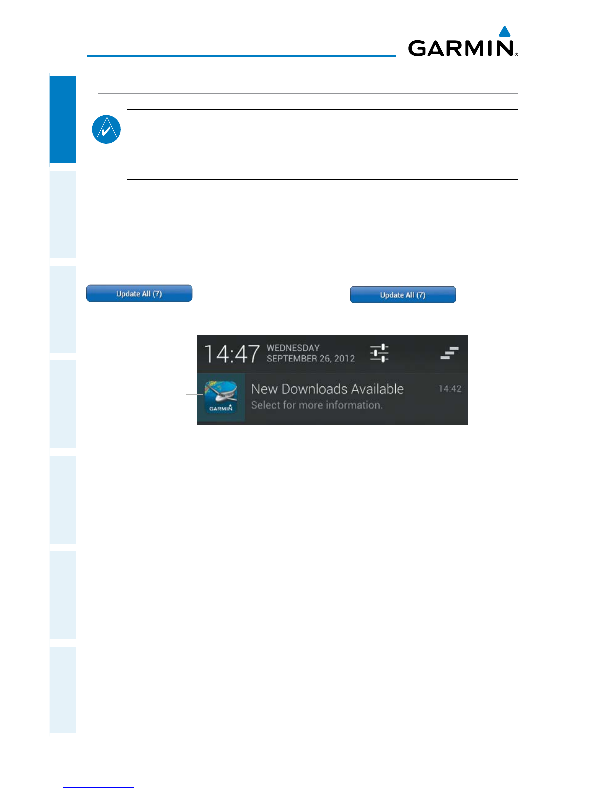
Garmin Pilot makes it easy to ensure that charts are always up-to-date by taking
advantage of the notification area of your Android device. When Garmin Pilot is started
it automatically checks for charts updates. When updates are available the Garmin
Pilot Icon is displayed in the notification area the device. The number of available
updates is also displayed on the Downloads Page. When updates are available, the
button becomes active. The Button will
update all available charts no matter the chart type.
New Downloads Available
Downloads
Notification
US Navigation Data, Airport Info and SafeTaxi are updated on 28-day cycle and are
available for download typically 5 days prior to their valid date.
WAC and Sectional Charts are updated individually on the chart schedule and are
available for download typically 5 days prior to their valid date.
US Instrument Procedures are updated on a 28-day cycle and are available for
download typically 5 days prior to their valid date.
IFR Low and High Altitude Charts are updated on a 28-day cycle and are available
for download typically 5 days prior to their valid date.
Charts that have been downloaded to the device are always available for viewing
even after their expiration date. If the next cycle chart is downloaded prior to its
activation date the current cycle will be used until it expires. After the expiration date
the next cycle chart will be used.
Page 49
Garmin Pilot for Android User’s Guide
190-01532-00 Rev. A
33
Overview
Overview Plan File Fly Subscriptions Appendices Index
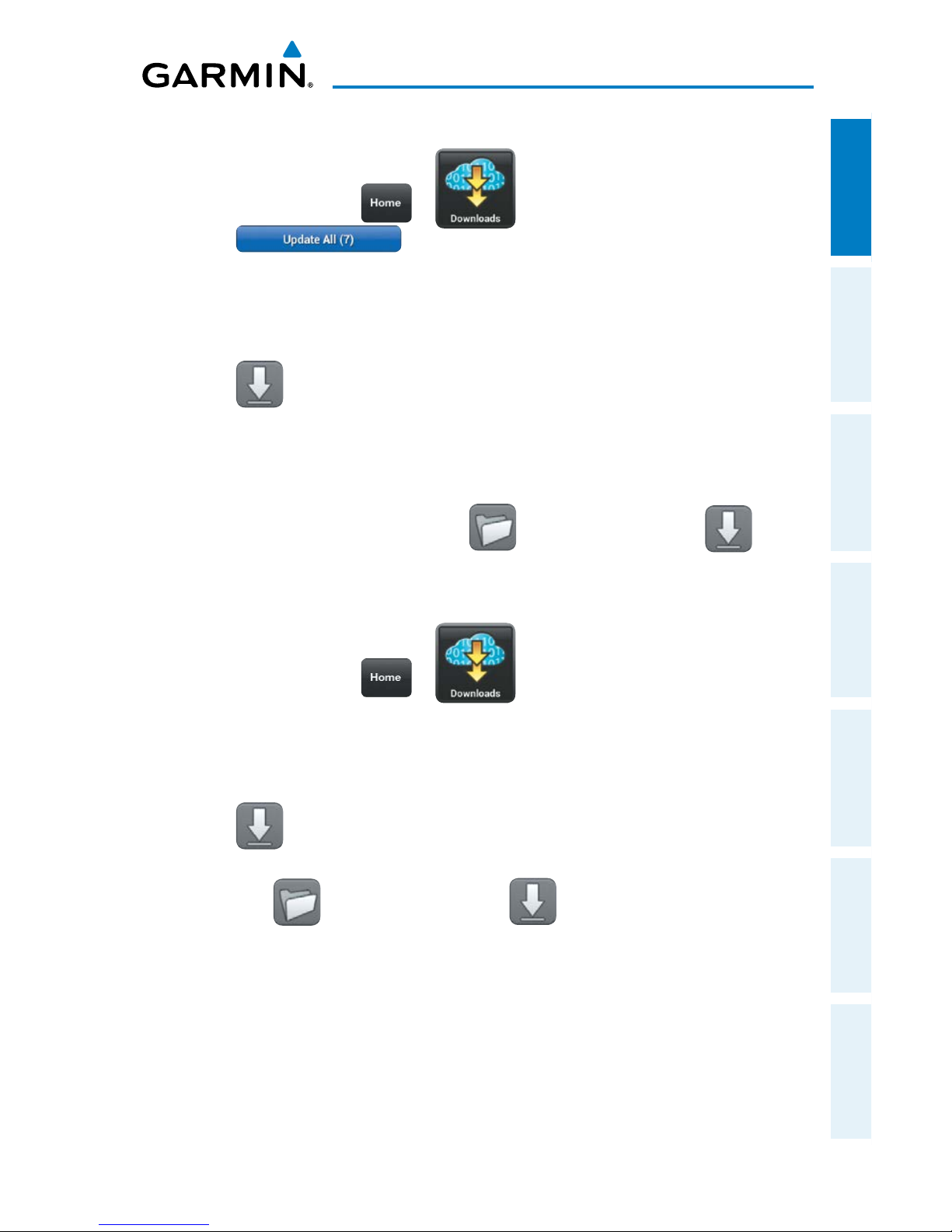
Updating
Sectional, WAC, IFR Low, or IFR High Altitude Charts:
1)
From any page tap > .
2) Tap to update all available charts.
Or
:
1) Select the desired chart type submenu.
2) From the Chart Selection Screen tap the expired chart(s), shown in red.
3) Tap to download the selected chart(s). The download will begin immediately
as shown in the Download Queue.
Or:
1) Select the desired chart type submenu.
2) From the Chart Selection Screen tap
> Update Expired > .
The
download will begin immediately as shown in the Download Queue.
Updating Instrument Procedures:
1)
From any page tap > .
2)
From the 'Procedures & Charts' list select the submenu for 'US Instrument
Procedures'.
3) From the Chart Selection Screen tap the expired chart(s), shown in red.
4) Tap to download the selected chart(s). The download will begin immediately
as shown in the Download Queue.
Or
: Tap
> Update Expired > , to update any expired charts.
Page 50
Garmin Pilot for Android User’s Guide
190-01532-00 Rev. A
34
Overview
OverviewPlanFileFlySubscriptionsAppendicesIndex
Blank Page
Page 51
Garmin Pilot for Android User’s Guide
190-01532-00 Rev. A
35
Plan
Overview Plan File Fly Subscriptions Appendices Index
PLAN
Garmin Pilot's powerful capabilities start with pre-flight planning, providing pilots
with the most comprehensive aviation weather information to make better-informed
flight decisions. Pilots can check weather radar, visible and infrared cloud imagery,
METARs, TAFs, AIRMETs, SIGMETs, PIREPs, NOTAMs, winds and temperatures aloft,
TFRs and lightning data. With Garmin Pilot, weather data can be overlaid on VFR
Sectionals, IFR low altitude en route charts, IFR high altitude en route charts, WAC,
or a simple map showing major roads and borders to visualize the weather for your
route. Add text-based weather widgets and use the exclusive NavTrack feature to view
weather information along the planned route.
ACTIVE FLIGHT PLAN
The Active Flight Plan page manages the current active flight plan. Flight plans can
be created, bookmarked (stored), and reversed from the Active Flight Plan Form. From
the Active Flight Plan form, flight plans can enter in one of two ways. First, tap within
the route field and use the keyboard to add waypoints separated by spaces. Second,
tap the ' Add Waypoint' button in the flight plan list and use the keyboard to enter
the waypoint identifier. Flight plans can also be edited on the map once a departure
point is entered. The Active Flight Plan form allows for flight plans to be bookmarked
or stored for later use.
Creating an Active Flight Plan:
1)
From any page tap > .
2)
Tap within the route field to activate the cursor.
3)
Use the keyboard to insert waypoints. Separate each waypoint with a
space.
Or:
1)
Tap the '
Add Waypoint' button.
2)
Use the keyboard to input the waypoint identifier.
Page 52
Garmin Pilot for Android User’s Guide
190-01532-00 Rev. A
36
Plan
OverviewPlanFileFlySubscriptionsAppendicesIndex
3)
Tap the '
Add Waypoint' button to add additional waypoints.
Or:
Enter Lat/Lon information in one of the following formats:
Lat/Lon Lat/Lon
####N/#####W
N##.#/W##.#
N####/W#####
##.#/-##.#
####/-#####
##.#N/0##.#W
##.#N/##.#W
##.#/-0##.#
N##.#/W0##.#
Spaces are not allowed, slash (/) is required. Any Latitude format can be combined
with any longitude format in the same string.
Lat/Lon Formats
Or:
Enter Radial/Distance waypoint in one of the following formats:
Radial/Distance Descriptions
MSP/190/035 or MSP/190/35
Identifier/Radial/Distance
MSP190035
IdentifierRadialDistance
Spaces are not allowed, when slashes (/) are used the leading zero can be left off
the radial and/or distance.
Radial/Distance Formats
Or:
1)
Use one of the above methods to enter a departure point.
2)
On the Map Page tap Menu > Graphical Route Edit.
3)
Long press on the map area to display the rubber-band. Place the rubberband on or near the desired location and then release the rubber-band. A
list of nearby waypoints is displayed.
4)
Select the desired waypoint from the list, or create a User Waypoint.
5)
Repeat steps 2-4 to add additional waypoints.
6)
Tap to save or to cancel.
Page 53
Garmin Pilot for Android User’s Guide
190-01532-00 Rev. A
37
Plan
Overview Plan File Fly Subscriptions Appendices Index
ACTIONS MENU
The Active Flight Plan List contains a waypoint-sensitive Actions Menu. For example
if the selected waypoint is the departure point, the Actions Menu will include an 'Add/
Remove SID'. If the selected point is the final destination, the Actions Menu will include
an 'Add/Remove STAR' action item. Or, if the selected waypoint is a valid Airway entry
point, the Actions Menu will include a 'Load Airway' action item. The Actions Menu
also has Action Items for adding, removing, or changing flight plan waypoints.
Action Description
Insert Before
Adds a new line item before the selected waypoint.
Places the cursor in the empty line and opens the
keyboard for waypoint identifier entry.
Insert After
Adds a new line item after the selected waypoint. Places
the cursor in the empty line and opens the keyboard for
waypoint identifier entry.
Remove Waypoint
Removes selected waypoint from the Active Flight Plan.
Waypoint Info
Displays Waypoint information.
Direct-To
Opens the Direct To... dialog box.
Add SID
Opens the SID submenu, listing available SIDs. Select the
desired SID to open the submenu of available transitions.
Clear Flight Plan
Removes all Flight Plan waypoints.
Expand
Expands SID, STAR, or Airways.
Change SID
Only available when the selected item is a SID. Allows
the SID and/or SID transition to be changed.
Remove SID
Only available when the selected item is a SID. Removes
SID from Active Flight Plan.
Load Airway
Only available if the selected item is valid airway entry
point. Opens submenu of available Airways. Once an
Airway is selected the Select Exit submenu displays a
list of available exit waypoints that can be ordered by
distance or alphabetically.
Page 54
Garmin Pilot for Android User’s Guide
190-01532-00 Rev. A
38
Plan
OverviewPlanFileFlySubscriptionsAppendicesIndex
Action Description
Remove Airway
Removes Airway and all associated waypoints.
Change Airway Entry
Opens the Change Entry submenu with a list of entry
points. The submenu can be viewed as an ordered list or
alphabetically.
Change Airway Exit
Opens the Change Exit submenu with a list of Airway exit
points. The submenu can be viewed as an ordered list or
alphabetically.
Change STAR
Opens the Edit STAR submenu with a list of available
STARs. Select the desired STAR to open the submenu of
available transitions.
Remove STAR
Removes STAR and all associated waypoints.
Add STAR
Opens the STAR submenu, listing available STARs. Select
the desired STAR to open the submenu of available
transitions.
Activate Leg
Actives the selected leg for navigation.
Action Menu Options
Adding a SID to an Active Flight Plan:
1)
From any page tap > .
2)
Tap the departure point in the Flight Plan List to open the Actions Menu.
3)
From the Actions Menu, tap .
4)
Tap the desired SID.
5)
Tap the desired transition. The SID, transition and associated waypoints are
added to the flight plan.
Adding a STAR to an Active Flight Plan:
1)
From any page tap > .
2)
Tap the destination in the Flight Plan List to open the Actions Menu.
Page 55
Garmin Pilot for Android User’s Guide
190-01532-00 Rev. A
39
Plan
Overview Plan File Fly Subscriptions Appendices Index
3)
From the Actions Menu, tap .
4)
Tap the desired STAR.
5)
Tap the desired transition. The STAR, transition, and associated waypoints
are added to the flight plan as a single entry that can be expanded to
view all waypoints. Once a STAR has been added to a flight plan, no more
waypoints can be added.
Adding an Airway to an Active Flight Plan:
1)
From any page tap > .
2)
Tap a waypoint in the Flight Plan List to open the Actions Menu.
3)
If the waypoint is a valid Airway entry point, tap in the
Actions Menu. Only valid Airway entry points will have the 'Load Airway'
action in the Actions Menu.
4)
Tap the desired Airway.
5)
Tap the desired Airway exit point from the list. All Airway waypoints from
selected entry point to selected exit point will be added to the flight plan
list as one entry that can be expanded to show all waypoints.
Expanding/Collapsing SID, STAR, or Airways in the Flight Plan List:
1)
From any page tap > .
2)
Tap to expand.
3)
Tap to collapse any of the expanded fields.
Bookmarking an Active Flight Plan:
1)
From any page tap > >
2)
Tap ' Bookmark current route' to bookmark the Active Flight Plan. The
Active Flight Plan and all associated waypoints are saved.
Page 56
Garmin Pilot for Android User’s Guide
190-01532-00 Rev. A
40
Plan
OverviewPlanFileFlySubscriptionsAppendicesIndex
Deleting Bookmarked Flight Plans:
1)
From any page tap > >
2)
Tap to delete the selected Flight Plan.
NOTE:
Flight Plans deleted from the Bookmarked FPLs list will also be deleted
from other devices when the next sync is performed.
Reversing the Active Flight Plan:
1)
From any page tap > .
2)
Tap to reverse the Active Flight Plan.
Page 57
Garmin Pilot for Android User’s Guide
190-01532-00 Rev. A
41
Plan
Overview Plan File Fly Subscriptions Appendices Index
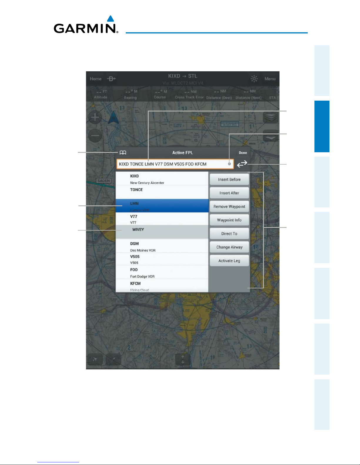
Active Flight Plan Form
Reverse
Flight Plan
Bookmark
Button
Route
Field
Selected
Waypoint
Expanded
Airway
Clear
Route
Field
Actions
Menu
Page 58
Garmin Pilot for Android User’s Guide
190-01532-00 Rev. A
42
Plan
OverviewPlanFileFlySubscriptionsAppendicesIndex
AIRPORT INFORMATION
Airport information is a downloadable product available free with your Garmin Pilot
subscription from the Downloads section of the Settings Menu. Because Garmin Pilot
will not automatically remove outdated charts, it is important to always ensure the
latest Data Cycle has been downloaded prior to planning a flight. The downloaded
cycle number and date range for every map data product is displayed on the Downloads
Page.
Finding airport information is easy with Garmin Pilot. The Home Button located at
the top of the map page contains the Airport Info icon. Tapping the icon will present
the Airport Information page with the last-found airport shown.
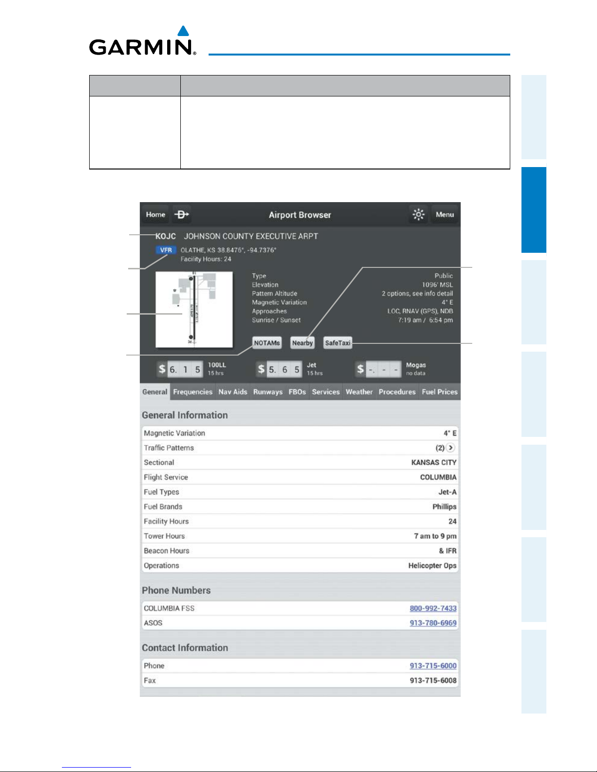
The Airport Information Page is divided into two sections. The top of the page under
the control bar is summary of airport information. Immediately below the summary are
nine selectable tabs for viewing detailed airport information. View detailed information
about some fields by tapping . The summary window contains the basic information
for the selected airport such as; elevation, pattern altitude, magnetic variation, sunrise/
sunset times, and fuel prices. There also three buttons in the summary area for displaying
NOTAMs, Nearby airports, or SafeTaxi (available for an additional subscription).
Tab Description
General
Traffic pattern altitudes, magnetic variation, Sectional information,
Flight Service, Fuel information, hours of operation, types of
operations, and pertinent phone numbers.
Frequencies
Communication and navigation radio frequencies.
Nav Aids
Nearest navigation aids, frequencies, distances, and radials.
Runways
Runway numbers, dimensions, composition, and conditions.
FBOs
Fixed base operations, contact information and services available.
Services
Nearby lodging, car rental, transportation, and dining information.
Weather
Current weather conditions including: METAR, TAF, Winds Aloft, and
Area Forecast.
Procedures
List of applicable procedures available for the current airport.
Page 59
Garmin Pilot for Android User’s Guide
190-01532-00 Rev. A
43
Plan
Overview Plan File Fly Subscriptions Appendices Index
Tab Description
Fuel Prices
Fuel prices on field, fuel prices organized by nearest airports, lowest
100LL and lowest Jet fuel, detailed FBO contact information,
services, and credit cards accepted. Fuel Prices are provided by
AirNav.
Airport Information Tabs
Airport Info Page
SafeTaxi
Button
Airport
Diagram
Thumbnail
Nearby
Button
Airport
Identifier
Current
Weather
NOTAMs
Button
Page 60
Garmin Pilot for Android User’s Guide
190-01532-00 Rev. A
44
Plan
OverviewPlanFileFlySubscriptionsAppendicesIndex
Within the Airport Summary window is an expandable thumbnail image of the
airport diagram. Momentarily tapping the airport diagram thumbnail will open a
larger view of the airport diagram. Tapping the image a second time will bring you
back to the previous page
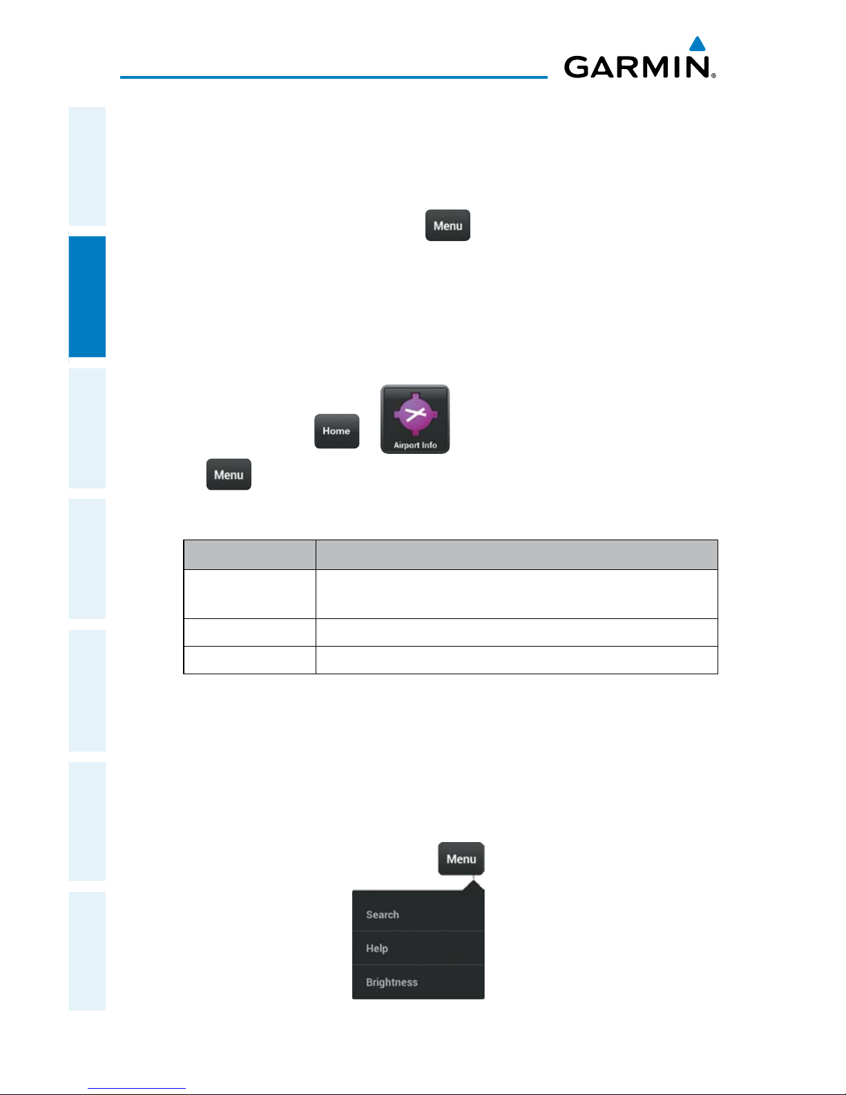
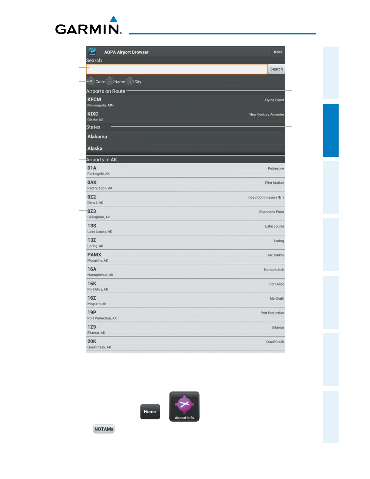
Searching airports is as easy as tapping
> Search
. This action opens the
AOPA Airport Browser. Use the search field, to search for airports by Code, Name, or
City. Quick links are also provided for any airports along the current active flight plan.
Airports can also be searched by State. Scroll the States list and tap the desired state
to view an alphabetical listing of airports by identifier.
Searching for an Airport:
1)
From any page tap > .
2)
Tap > Search.
3)
Select a search criteria.
Search Criteria Description
Code
Search by the three letter or four character (alphanumeric) airport
code (i.e., KLAX)
Name
Search by name (i.e., Los Angeles Intl).
City
Search by city (i.e., Los Angeles, CA).
Airport Search Options
Or:
Select a state from the list and tap the desired airport from the alphabetical
list.
Or:
Select an airport from the Airports on Route list.
4)
Select an airport from the Search Results list.
Airport Info Page Menu
Page 61
Garmin Pilot for Android User’s Guide
190-01532-00 Rev. A
45
Plan
Overview Plan File Fly Subscriptions Appendices Index
Airport
Search
Field
AOPA Airport Browser
States
List
Airports
on Route
Search
Criteria
Airports
by State
or Search
Results
Airport
Code
Airport
City,
State
Airport
Name
Viewing NOTAMs:
1)
From any page tap > .
2)
Tap to view the NOTAMs window.
Page 62
Garmin Pilot for Android User’s Guide
190-01532-00 Rev. A
46
Plan
OverviewPlanFileFlySubscriptionsAppendicesIndex
Viewing Nearby Airports:
1)
From any page tap > .
2)
Tap to view airports (i.e., Public or All) nearby the currently selected
airport.
Viewing SafeTaxi (Subscription Required):
1)
From any page tap > .
2)
Tap to view the SafeTaxi airport diagram.
3)
Tap to return to the Airport Info Page.
Viewing and Organizing Procedures:
NOTE:
Terminal procedures (i.e. SIDs, STARs, instrument approach procedures,
airport diagrams, Hot Spots, and Take-off Minimums) are available for selection
from the Airport Information Page. Any charts that are not geo-referenced will
open in the default PDF document viewer.
1)
From any page tap > .
2)
Tap the Procedures Tab. All available charts and procedures are shown
including; (Airport Diagrams, Approach Procedures, Arrival Procedures, and
Departures). Chart titles followed by ,will need to be downloaded.
Charts followed by have already been downloaded to the device.
3)
Tap the desired chart to view.
Or:
To organize charts
4)
Tap to create a Chart Binder or add to an existing binder.
5)
Tap and enter a Binder Name or select from the list of available binders.
6)
Tap for each additional chart to add to a binder.
Page 63
Garmin Pilot for Android User’s Guide
190-01532-00 Rev. A
47
Plan
Overview Plan File Fly Subscriptions Appendices Index
TRIP PLANNING
NOTE:
A data connection (i.e., Wi-Fi or cellular) is required to receive preflight
weather briefings, file, amend, cancel or close flight plans from Garmin Pilot.
The Trip Planning Page manages all of the trip planning details for the active flight
plan. Complete the trip plan by entering pilot information, selecting the file service,
Aircraft, Rules, TAS, Burn Rate, Fuel, Fuel units, ETD and Altitude Some of the data will
be auto-filled based on aircraft performance data from your flyGarmin account. Once
all mandatory fields have been completed, Garmin Pilot creates a trip summary, and
navlog. Since Garmin Pilot is connected to a DUAT account, flight plans can be filed,
canceled or closed with Garmin Pilot.
PLANNING A TRIP
ROUTE
The route of flight is determined by the active flight plan.
Entering Pilot Information:
1)
From any page tap > .
2)
Tap the Pilot field.
3)
Enter pilot's Name, Telephone, Street, City, State and Zipcode (if linked to a
flyGarmin account fields may already be populated).
Entering File Service Information:
1)
From any page tap > .
2)
Tap File Service
3)
Enter CSC or DTC credentials and select the preferred provider.
4)
Tap , to save and exit.
Page 64
Garmin Pilot for Android User’s Guide
190-01532-00 Rev. A
48
Plan
OverviewPlanFileFlySubscriptionsAppendicesIndex
Entering Aircraft Information:
1)
From any page tap > .
2)
Tap the Aircraft field.
3)
Select the desired aircraft from the list or enter; identifier, type, equip suffix,
home base, colors and performance information.
NOTE:
Performance data is used to create Navlog and to calculate trip
parameters.
Selecting the Flight Plan Rules:
1)
From any page tap > .
2)
Select VFR or IFR
Entering TAS, Burn Rate and Fuel:
1)
From any page tap > .
2)
Tap the applicable field and enter the desired value(s). The fields are
automatically populated with the values entered for the aircraft. Any
changes made will be applied to the filed flight plan.
Entering ETD:
1)
From any page tap > .
2)
Tap the ETD field and enter the desired time.
Entering Altitude:
1)
From any page tap > .
2)
Tap the Altitude field and select the desired altitude. Available altitudes are
based on rules (i.e., VFR or IFR) selected.
Page 65
Garmin Pilot for Android User’s Guide
190-01532-00 Rev. A
49
Plan
Overview Plan File Fly Subscriptions Appendices Index
FLIGHT SUMMARY
The Flight Summary displays the following information: Total Distance, True Airspeed,
Total Time En Route, Direct True Course, Average Groundspeed, and Total Fuel Burned.
Values are based on currently reported weather conditions and the user provided
aircraft performance data.
NAVLOG
Garmin Pilot generates a navigation log using the Active Flight Plan waypoints, userprovided Trip Plan information, user-provided aircraft performance data, and DUAT
-sourced weather data. The navlog provides navigation information for each leg of the
Active Flight Plan. The column values are user selectable, tap each column header to
cycle through the available units, or long-press a column header to change the column
group.
Course Headings Speed Distance Time Fuel Wind
Magnetic
Course
(MC)
Magnetic
Heading
(MH)
True
Airspeed
(TAS)
Leg
Distance
(Dist Leg)
Estimated
Time of
Arrival Zulu
(ETA)
Leg Fuel
(Fuel Leg)
Wind (Wind
Speed)
True
Course
(TC)
Wind
Correction
(WCA)
Ground
Speed
(GS)
Combined
Distance
Done (Dist
Done)
Estimated
Time En
Route Leg
(ETE Leg)
Fuel
Remaining
after leg
(Fuel Rem)
Crosswind
(XWND)
Distance
Remaining
(Dist Rem)
Estimated
Time En
Route Flown
(ETE Flown)
Cumulative
Fuel
Burned
(Fuel Used)
Head Wind
(HdWnd)
Estimated
Time En
Route
Remaining
(ETE Rem)
Temperature
(Temp)
Navlog Column Options
Page 66
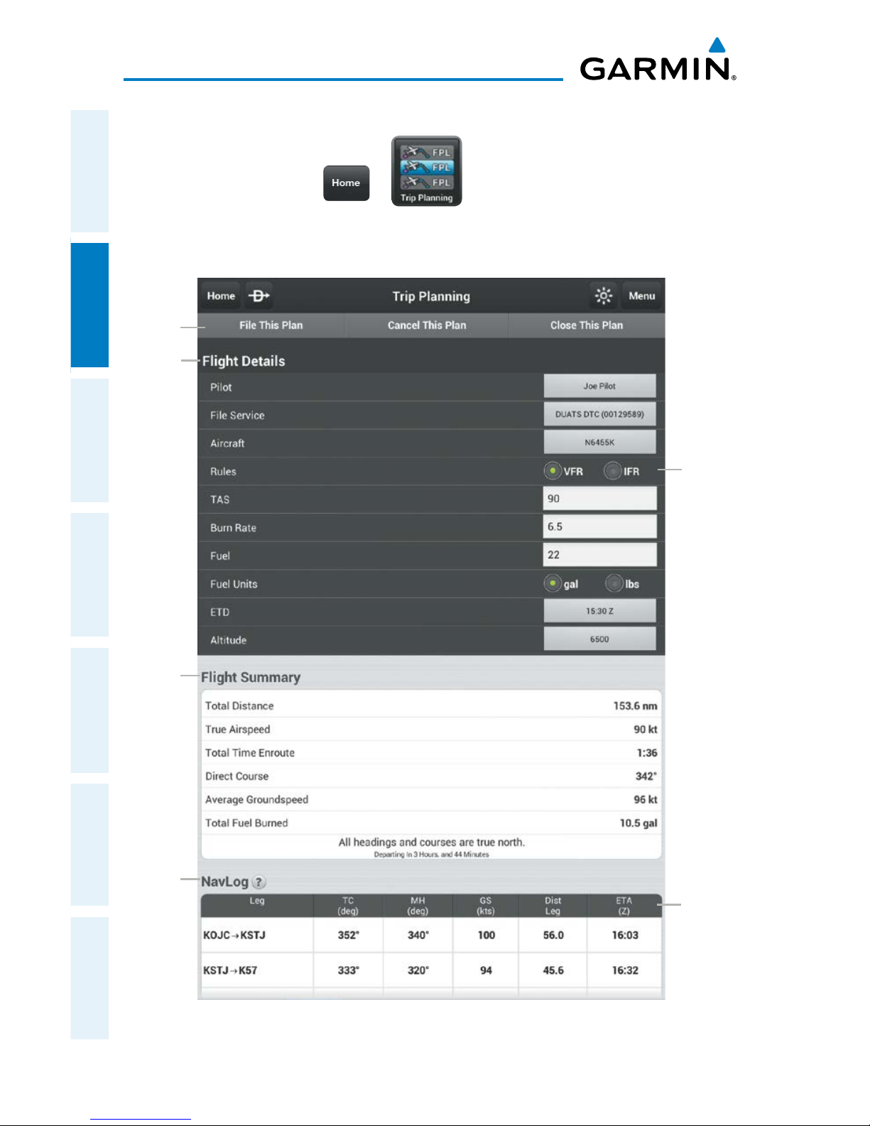
Garmin Pilot for Android User’s Guide
190-01532-00 Rev. A
50
Plan
OverviewPlanFileFlySubscriptionsAppendicesIndex
Changing Navlog Column Values:
1)
From any page tap > .
2)
Tap a column header to cycle units or long-press a column header to
change the column group.
File
Actions
Trip Planning Page
Plan
Rules
Flight
Details
Flight
Summary
NavLog
Column
Header
Page 67
Garmin Pilot for Android User’s Guide
190-01532-00 Rev. A
51
Plan
Overview Plan File Fly Subscriptions Appendices Index
WEATHER DATA
WARNING: Do not use the indicated data link weather product age to determine the
age of the weather information shown by the data link weather product. Due to time
delays inherent in gathering and processing weather data for data link transmission, the
weather information shown by the data link weather product may be significantly older
than the indicated weather product age.
WARNING: Do not use data link weather information for maneuvering in, near, or
around areas of hazardous weather. Information contained with in data link weather
products may not accurately depict current weather conditions.
Weather is presented in Widgets (as text), and map overlays. To receive up-todate weather information, the device must have access to a data connection (Wi-Fi or
cellular), or a GDL 39. However, once downloaded, some weather products will remain
available for up to 90 minutes after connection to the Internet is lost.
WEATHER WIDGETS
Weather Widgets are viewable in the lower portion of the Map Page in split screen.
Controls located at the upper left and right corners of each Widget open a menu that
allows you to select the Widget Type and to choose an airport to which the Widget is
applicable.
The NavTrack located at the bottom of the display enables you to dynamically change the
Widget location to view information related to points on or near the active route. Dragging
the slider at the bottom of the widgets pane moves a light blue diamond along the route
of flight. As the symbol approaches airports along the active route Colored push-pins
correspond to matching colored dots to the left of the airport identifier in the upper right
corner of the Widget to indicate the location from which the information contained in the
Widget originates.
There are six weather, and three navigation information products available for selection
from the Widget Type menu. The weather products available to be displayed as widgets are
METAR, TAF, PIREPs, winds and temperatures aloft, area forecast, and AIRMET/SIGMETs.
The three navigation information products are NOTAMs, Fuel Prices and TFRs.
Sliding a finger left or right over the widgets will bring more widgets or the ‘Add Widget’
tool into view. The source, product age and relative location will be displayed at the
bottom of each widget.
Page 68
Garmin Pilot for Android User’s Guide
190-01532-00 Rev. A
52
Plan
OverviewPlanFileFlySubscriptionsAppendicesIndex
Adding a Weather Widget:
1)
From any page tap > .
2)
Tap > Split Screen > Widgets.
3)
Drag the Widgets from right to left and tap the plus button to add a widget.
4)
Select a widget from the ‘Select Widget Type’ menu.
Changing a Widget Type:
1)
Tap the widget type as displayed in the upper left corner of the widget.
2)
Select the desired widget type from the ‘Select Widget Type’ menu.
Removing a Weather Widget:
1)
Tap the widget type as displayed in the upper left corner of the widget.
2)
Scroll to the bottom of the flick list.
3)
Select ‘Delete Widget’ from the bottom of the menu.
WIDGET NAVTRACK
At the bottom of the widget pane is the NavTrack. Touch-dragging the slider moves
a light blue diamond along the route of flight. Colored push-pins appear on the map
to indicate locations near the blue diamond that provide information corresponding
to selected widgets. In some cases, there may be more than one location near the
blue diamond that provides information corresponding to a widget. To view weather
information for nearby locations, it may be necessary to tap the inverted white triangle
next to the widget location in the widget header bar. This will open a menu of nearby
widget information sources.
Change the Location Associated with a Weather Widget:
1)
Drag the NavTrack at the bottom of the widget pane until the blue diamond
corresponds with a colored push-pin on the map display that is near a
desired location.
2)
If the push-pin does not correspond to the desired location, tap the
location indicator at the top right corner of the widget to search for nearby
locations.
3)
Select the desired location from the ‘Nearby’ menu.
Page 69
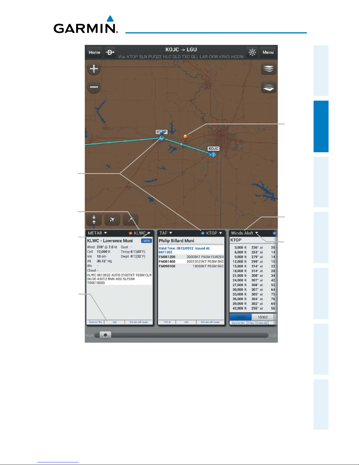
Garmin Pilot for Android User’s Guide
190-01532-00 Rev. A
53
Plan
Overview Plan File Fly Subscriptions Appendices Index
Widgets
Push
Pin
Push Pin
Color and
Widget
Location
Correspond
Weather
Product
Source,
Age and
Relative
Location
Widget
Type
Tap to
Change
Widget
Type
Widget
Location
Tap to
Change
Widget
Location
Page 70
Garmin Pilot for Android User’s Guide
190-01532-00 Rev. A
54
Plan
OverviewPlanFileFlySubscriptionsAppendicesIndex
RADAR
Weather radar data is collected from radar sites across the United States, Canada,
and select overseas locations. It is combined into a mosaic for easier display and
analysis.
The radar data displayed is not real-time. The lapsed time between collection,
processing, and dissemination of radar images can be significant and may not reflect
the current radar synopsis. Due to the inherent delays and the relative age of the
data, it should be used for long-range planning purposes only. Never use radar data
to penetrate hazardous weather. Rather, use it in an early-warning capacity for predeparture evaluation.
Composite data from radar sites in the United States is shown. This data is
composed of the maximum reflectivity from the individual radar sweeps at different tilt
angles of the radar beam with respect to the ground. The display of the information
is color-coded to indicate the weather severity level. Colors are used to identify the
different echo intensities (reflectivity) measured in dBZ (decibels or Z). “Reflectivity”
(designated by the letter Z) is the amount of transmitted power returned to the radar
receiver. The dBZ values increase as returned signal strength increases. Precipitation
intensity is displayed using colors corresponding to the dBZ values.
RADAR ABNORMALITIES
There are possible abnormalities regarding displayed radar images. Some, but not
all, of those include:
•Groundclutter
•Strobesandspuriousradardata
•Sunstrobes(whentheradarantennapointsdirectlyatthesun)
•Militaryaircraftdeploymetallicdust(chaff)whichcancausealterationsinradar
scans
•Interferencefrombuildingsormountains,whichmaycauseshadows
Page 71
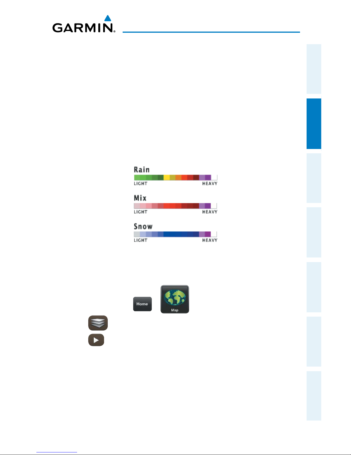
Garmin Pilot for Android User’s Guide
190-01532-00 Rev. A
55
Plan
Overview Plan File Fly Subscriptions Appendices Index
RADAR LIMITATIONS
Certain limitations exist regarding radar displays. Some, but not all, are listed for
the user’s awareness:
•Surfaceprecipitationtypeisestimatedwithshadesofblueforsnowandshades
of pink for indeterminate types. The actual precipitation type aloft could vary.
•Radarbasereectivityissampledattheminimumantennaelevationangle.An
individual radar site cannot depict high altitude storms at close ranges, and has
no information about storms directly over the site.
•RadarcoverageinCanadaisonlyavailableinthesouthern1/4ofthecountry.
Radar Intensity
Viewing Radar Information:
1)
From any page tap > .
2)
Tap select 'Radar' from the Layer Select menu.
3)
Tap to animate the radar loop. Each frame of the radar loop is time
stamped. The time stamp is just right of the play button.
Page 72
Garmin Pilot for Android User’s Guide
190-01532-00 Rev. A
56
Plan
OverviewPlanFileFlySubscriptionsAppendicesIndex
INFRARED SATELLITE (IR SAT)
IR Sat displays infrared composite satellite images of cloud cover taken by
geostationary weather satellites.
Viewing Infrared Satellite Information:
1)
From any page tap > .
2)
Tap select 'IR Clouds' from the Layer Select menu.
3)
Tap to animate the satellite loop. Each frame of the satellite loop is
time stamped. The time stamp is just right of the play button.
Viewing Visible Satellite Information (Vis Sat):
1)
From any page tap > .
2)
Tap select 'Vis Clouds' from the Layer Select menu.
3)
Tap to animate the satellite loop. Each frame of the satellite loop is
time stamped. The time stamp is just right of the play button.
WEATHER OVERLAY
The Weather Overlay provides weather icons that graphically display one of 14
parameters typically reported in a METAR. Each icon can be tapped to display the
current METAR data in both raw and translated formats. Color coded icons provide a
quick visual representation of the current weather conditions. Blue icons indicate VFR
conditions, Green icons indicate MVFR conditions, Yellow icons indicate IFR conditions
and Red icons indicate LIFR conditions. The color coding applies to Station ID, Flight
Conditions, Cloud Ceiling, Visibility, and Cloud Cover.
Wind barbs and wind speed icons are slightly different where green is used to
indicate winds of less than 10 kts, yellow is for winds greater than 10 kts and red is
used for winds greater than 20 kts. Colored icons are also used to show dew point
spread where the spreads of five degrees or greater are green, spreads of three or four
degrees are yellow and spreads of two degrees or less are red.
Page 73
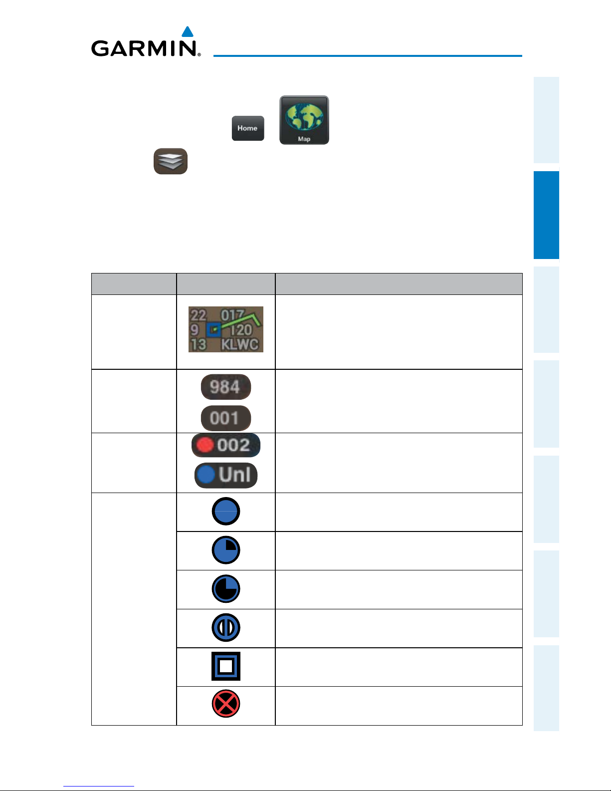
Garmin Pilot for Android User’s Guide
190-01532-00 Rev. A
57
Plan
Overview Plan File Fly Subscriptions Appendices Index
Viewing and Configuring the Weather Overlay:
1)
From any page tap > .
2)
Tap and select 'Weather' from the Layer Select menu.
3)
Tap the Overlay Control button in the lower left corner.
4)
Select the desired option from the list.
5)
Tap any of the displayed Weather Icons to view the Raw and translated
METAR information.
Layer Icons Description
Station
Model
When reading the station model clockwise
provides current; altimeter, ceiling, identifier,
dewpoint, visibility and temperature. Also
provides current wind and cloud cover as icons.
Altimeter
Altimeter ("Hg) setting with the leading 2 or
3 omitted as well as the decimal. (e.g., 984 =
29.84 or 001 = 30.01)
Cloud Ceiling
Reported ceiling in hundreds of feet or 'Unl'
if there is not a could layer that constitutes a
ceiling.
Cloud Cover
Overcast
Broken
Scattered
Few
Clear
Fog
Page 74
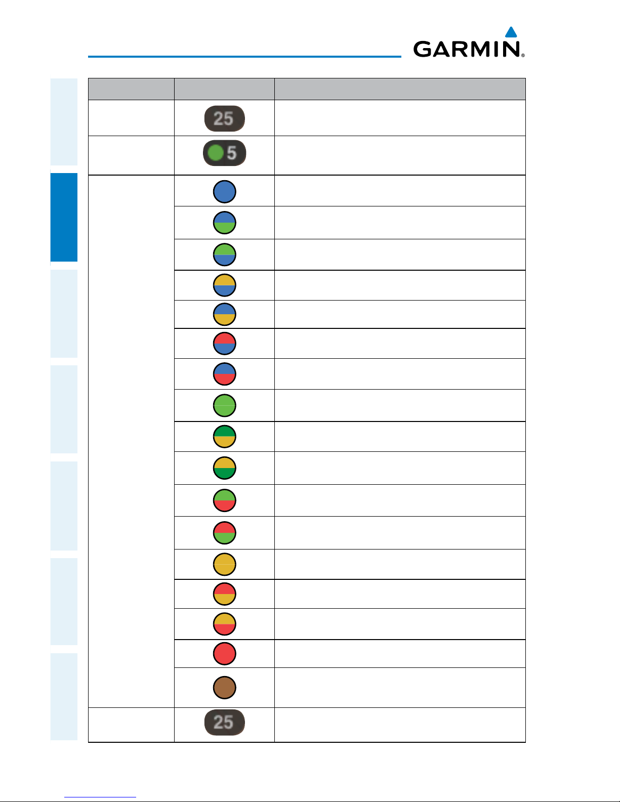
Garmin Pilot for Android User’s Guide
190-01532-00 Rev. A
58
Plan
OverviewPlanFileFlySubscriptionsAppendicesIndex
Layer Icons Description
Dew point
Dew point °C
Dew point
Spread
Dew point Spread °C
Flight
Conditions
VFR
VFR ceiling with MVFR visibility.
MVFR ceiling with VFR visibility.
IFR ceiling with VFR visibility.
VFR ceiling with IFR visibility.
LIFR ceiling with VFR visibility.
VFR ceiling with LIFR visibility.
MVFR
MVFR ceiling with IFR visibility.
IFR ceiling with MVFR visibility
MVFR ceiling with LIFR visibility
LIFR ceiling with MVFR visibility
IFR
LIFR ceiling with IFR visibility
IFR ceiling with LIFR visibility
LIFR
Missing weather information. A split dot with
brown indicates partial missing data.
Observation
Age
Observation Age in minutes
Page 75
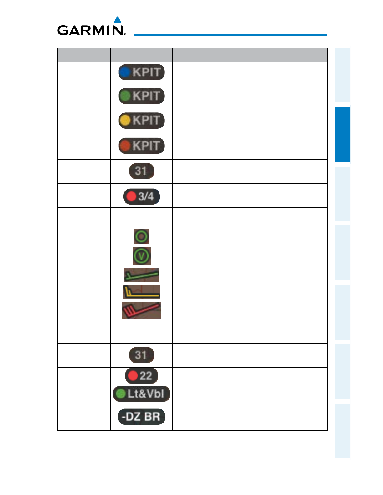
Garmin Pilot for Android User’s Guide
190-01532-00 Rev. A
59
Plan
Overview Plan File Fly Subscriptions Appendices Index
Layer Icons Description
Station ID
VFR conditions (Blue)
MVFR conditions (Green)
IFR conditions (Yellow)
LIFR conditions (Red)
Temperature
Temperature °C
Visibility
Reported Visibility in statute miles.
Wind Barbs
Wind barbs indicate wind speed and direction
and always point in the direction that the wind is
coming from. The wind speed is depicted using
flags at the end of the wind barb. A short wind
flag is 5 knots, a long wind flag is 10 knots, and
a filled triangle is 50 knots. Wind Barbs are also
color coded where green barbs indicate wind is
5-9 kts, yellow barbs are 10-19 kts and red is for
winds of 20 kts or greater. When winds are calm
an open green circle is used. Light and variable
winds are indicated by an open green circle with
a green 'V'.
Wind Gust
Reported wind gusts (kts).
Wind Speed
Reported steady wind speed (kts).
Wx
Conditions
Dynamic black shaded box that displays two
letter weather condition codes and qualifiers.
Weather Icons
Page 76
Garmin Pilot for Android User’s Guide
190-01532-00 Rev. A
60
Plan
OverviewPlanFileFlySubscriptionsAppendicesIndex
AIRMETS
An AIRMET (AIRmen’s METeorological Information) can be especially helpful for
pilots of light aircraft that have limited flight capability or instrumentation. An AIRMET
must affect or be forecasted to affect an area of at least 3,000 square miles at any one
time. AIRMETs are routinely issued for six-hour periods and are amended as necessary
due to changing weather conditions. AIRMETs are displayed as green (IFR/mountain
obscuration), orange (turbulence), or blue (icing) shaded areas on the map display.
SIGMETS
A SIGMET (SIGnificant METeorological Information) advises of weather that is
potentially hazardous to all aircraft. In the contiguous United States, the following
items are covered: severe icing, severe or extreme turbulence, volcanic ash (red), dust
storms, and sandstorms that lower visibility to less than three statute miles.
A Convective SIGMET is issued for thunderstorms, isolated severe thunderstorms,
embedded thunderstorms, hail at the surface, and tornadoes.
A SIGMET is widespread and must affect or be forecast to affect an area of at least
3,000 square miles.
Viewing AIRMETS and SIGMETS:
1)
From any page tap > .
2)
Tap and select 'AIRMET/SIGMET' from the Layer Select menu.
3)
Tap and select the desired type of AIRMET/SIGMET (i.e., Convective,
Icing, IFR/MTN, or Turbulence) to display.
4)
Tap within the shaded area for AIRMET/SIGMET details.
Page 77
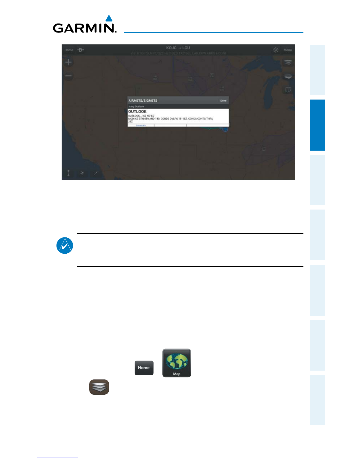
Garmin Pilot for Android User’s Guide
190-01532-00 Rev. A
61
Plan
Overview Plan File Fly Subscriptions Appendices Index
AIRMET/SIGMET Layer
TEMPORARY FLIGHT RESTRICTIONS (TFRS)
NOTE:
Do not rely solely upon data link services to provide Temporary Flight
Restriction TFR information. Always confirm TFR information through official
sources such as Flight Service Stations or Air Traffic Control.
Temporary Flight Restrictions or TFRs temporarily restrict all aircraft from entering
the selected airspace unless a waiver has been issued. TFRs are routinely issued for
occurrences such as sporting events, dignitary visits, military depots and forest fires.
TFRs are represented as an area outlined in dark blue (special events), green (forest
fires), or Red (dignitary visits).
Viewing Temporary Flight Restrictions (TFR):
1)
From any page tap > .
2)
Tap and select 'TFR' from the Layer Select menu.
3)
Tap within the outlined area for TFR details.
Page 78
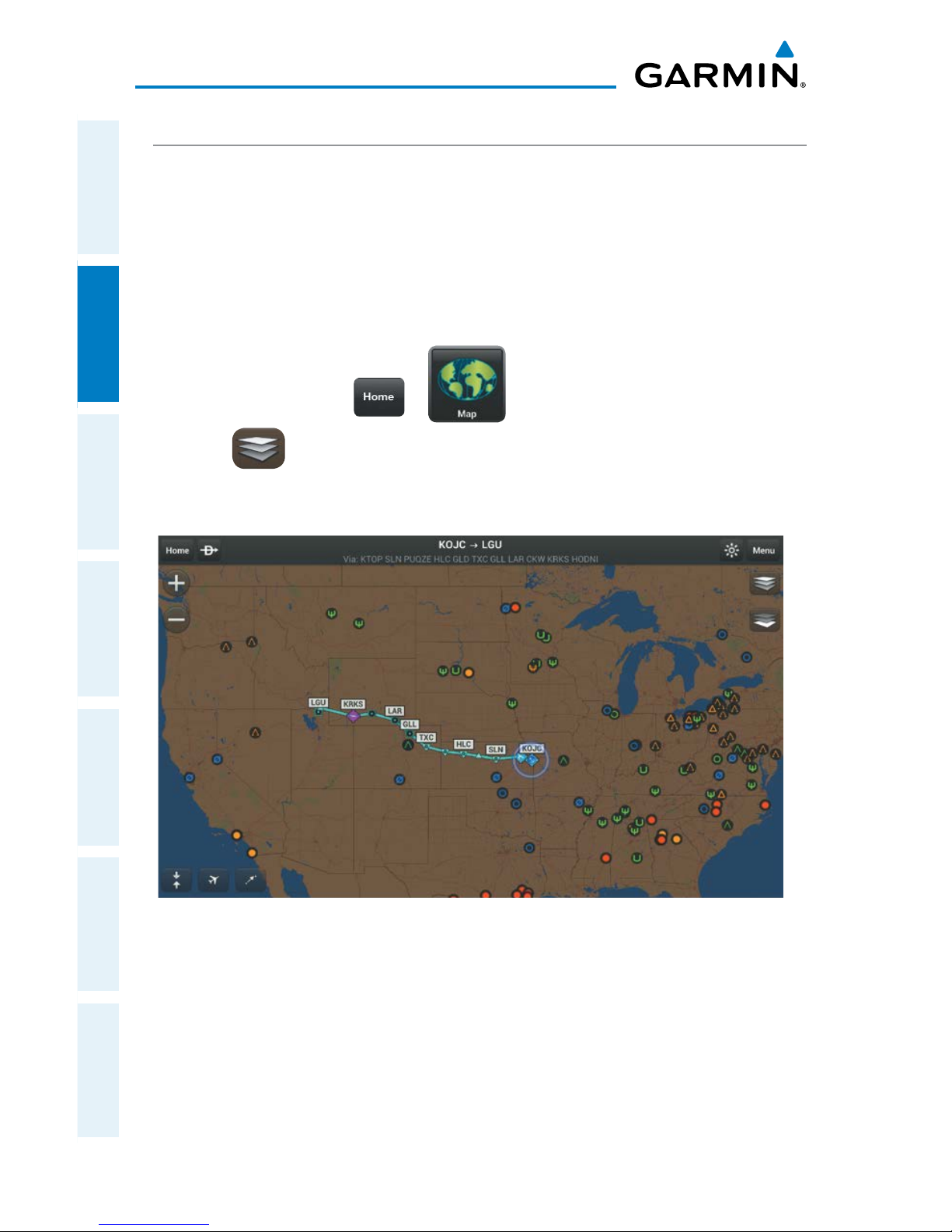
Garmin Pilot for Android User’s Guide
190-01532-00 Rev. A
62
Plan
OverviewPlanFileFlySubscriptionsAppendicesIndex
PIREPS
Pilot Weather Reports (PIREPs) provide timely weather information for a particular
route of flight. When significant weather conditions are reported or forecast, Air Traffic
Control (ATC) facilities are required to solicit PIREPs. A PIREP may contain unforecast
adverse weather conditions, such as low in-flight visibility, icing conditions, wind shear,
and turbulence. PIREPs are issued as either Routine (UA) or Urgent (UUA).
Viewing PIREPs:
1)
From any page tap > .
2)
Tap and select 'PIREPs' from the Layer Select menu.
3)
Tap the PIREP icon for details.
PIREP Layer
Page 79
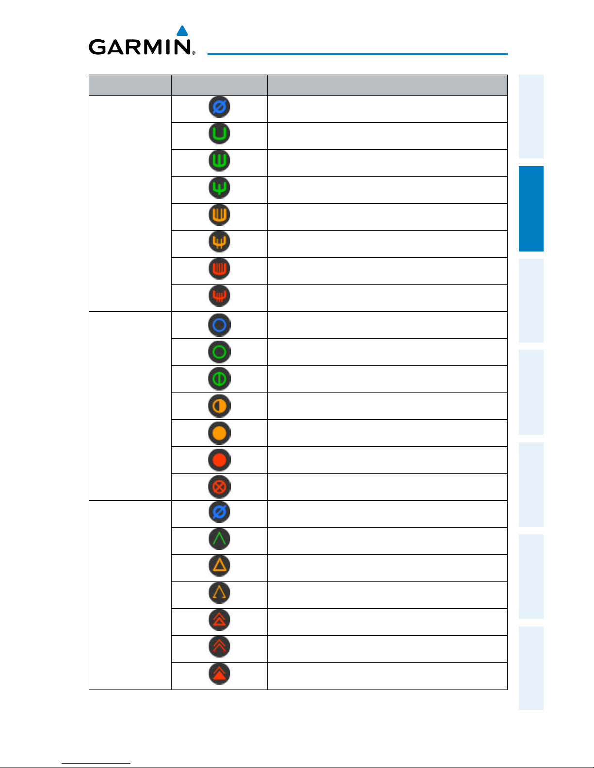
Garmin Pilot for Android User’s Guide
190-01532-00 Rev. A
63
Plan
Overview Plan File Fly Subscriptions Appendices Index
PIREP TYPE Icons Description
Icing
Negligible Icing
Trace Icing
Trace to Light Icing
Light Icing
Light to Moderate Icing
Moderate Icing
Moderate to Severe Icing
Severe Icing
Sky
Conditions
Unknown Sky Condition
Sky Clear
Few Clouds
Scattered Clouds
Broken Clouds
Overcast
IMC
Turbulence
Turbulence Negligible or Smooth
Light Turbulence
Light to Moderate Turbulence
Moderate Turbulence
Moderate to Severe Turbulence
Severe Turbulence
Extreme Turbulence
PIREP Icons
Page 80
Garmin Pilot for Android User’s Guide
190-01532-00 Rev. A
64
Plan
OverviewPlanFileFlySubscriptionsAppendicesIndex
LIGHTNING
Lightning data shows the approximate location of cloud-to-ground lightning strikes.
A strike icon represents a strike that has occurred within a two-kilometer region. The
exact location of the lightning strike is not displayed.
Viewing Lightning Information:
1)
From any page tap > .
2)
Tap and select 'Lightning' from the Layer Select menu.
3)
Tap to animate the Lightning loop. Each frame of the Lightning loop
is time stamped. The time stamp is just right of the play button. Lightning
information is available in one minute increments for the previous 45
minutes.
WINDS ALOFT
Winds Aloft data shows the forecasted wind speed and direction at the surface
and at selected altitudes. Altitudes can be displayed in 3,000-foot increments up to
42,000 feet MSL.
Winds Aloft are displayed using wind barbs. The wind barbs indicate wind speed
and direction. The wind speed is depicted using flags at the end of the wind barb. A
short wind flag is 5 knots, a long wind flag is 10 knots, and a filled triangle is 50 knots.
Wind barbs are also color coded to indicate wind speed. Wind direction is depicted by
the flagged end of the barb. The flagged end indicates the direction from which the
wind is coming.
Viewing Winds Aloft Information:
1)
From any page tap > .
2)
Tap and select 'Winds Aloft' from the Map Overlay menu.
3)
Drag the horizontal slider to the right to view forecast winds aloft.
Page 81
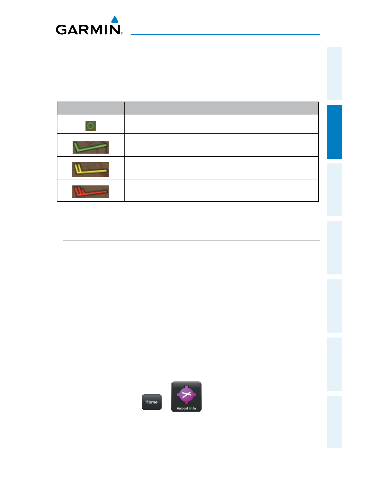
Garmin Pilot for Android User’s Guide
190-01532-00 Rev. A
65
Plan
Overview Plan File Fly Subscriptions Appendices Index
4)
Drag the slider up to the desired altitude. Altitudes are displayed in 3,000foot increments up to 42,000 feet MSL.
Or:
Tap any wind barb to view a winds aloft table. Tap the time to view
current/forecasted winds aloft.
Icons
Description
Green circle indicates calm winds.
Green barbs indicate winds of 10 kts or less.
Yellow barbs indicate winds of 20 kts or less.
Red barbs indicate winds or 21 kts or greater.
Winds Aloft Barbs
METARS AND TAFS
METAR (METeorological Aerodrome Report) is an international code used for
reporting weather observations. METARs are updated hourly or as needed. METARs
typically contain information about the temperature, dew point, wind, precipitation,
cloud cover, cloud heights, visibility, and barometric pressure. They can also contain
information on precipitation amounts, lightning, and other critical data.
TAF (Terminal Area Forecast) is the standard format for 24-hour weather forecasts.
TAFs may contain some of the same code as METAR data. It typically forecasts
significant weather changes, temporary changes, probable changes, and expected
changes in weather conditions.
METAR and TAF data are displayed as raw and/or decoded text (METAR only).
Viewing METAR and TAF Information:
1)
From any page tap > .
2)
Select the Weather Tab to view METAR, TAF, and Winds Aloft for the
selected airport.
Page 82
Garmin Pilot for Android User’s Guide
190-01532-00 Rev. A
66
Plan
OverviewPlanFileFlySubscriptionsAppendicesIndex
Blank Page
Page 83
Garmin Pilot for Android User’s Guide
190-01532-00 Rev. A
67
File
Overview Plan File Fly Subscriptions Appendices Index
FILE
With Garmin Pilot, users can easily enter a flight plan and interactively edit it on
the map. Pre-loaded forms makes it quick to save and reuse data for frequently flown
routes. And when the flight plan is ready, Garmin Pilot make it simple to file, cancel or
close the flight plan via DTC DUAT or CSC DUATS.
PREPARING TO FILE
NOTE:
Prior to filing the flight plan, ensure that all of the information entered on the
Trip Planning Page is correct including the route of flight.
Garmin Pilot provides a quick and easy method to file, close or cancel flight plans.
When Garmin Pilot is connected to a DUATS account, route of flight, pilot information,
aircraft information, type of flight plan (IFR/VFR), number of persons onboard, fuel
onboard, date, estimated time of departure (ETD), altitude, airspeed, and any optional
data including alternate, and remarks are transmitted to DUATS The ETD must be at
least 30 minutes in the future or the flight plan will not be transmitted. To file a flight
plan with a departure time less than 30 minutes in the future you must call the FSS.
TRIP PLANNING
Entering Pilot Information:
1)
From any page tap > .
2)
Tap the Pilot field.
3)
Enter pilot's Name, Telephone, Street, City, State and Zipcode (if linked to a
flyGarmin account fields may already be populated).
Entering File Service Information:
1)
From any page tap > .
2)
Tap File Service
Page 84
Garmin Pilot for Android User’s Guide
190-01532-00 Rev. A
68
File
OverviewPlanFileFlySubscriptionsAppendicesIndex
3)
Enter CSC or DTC credentials and select the preferred provider.
4)
Tap , to save and exit.
Entering Aircraft Information:
1)
From any page tap > .
2)
Tap the Aircraft field.
3)
Select the desired aircraft from the list or enter; identifier, type, equip suffix,
home base, colors and performance information.
NOTE:
Performance data is used to create the NavLog and to calculate trip
parameters.
Selecting the Flight Plan Rules:
1)
From any page tap > .
2)
Tap the radial button for the desired rules (i.e., VFR or IFR)
Entering TAS, Burn Rate and Fuel:
1)
From any page tap > .
2)
Tap the applicable field and enter the desired value(s). The fields are
automatically populated with the values entered for the aircraft. Any
changes made will be applied to the filed flight plan.
Entering ETD:
1)
From any page tap > .
2)
Tap the ETD field and enter the desired time.
Page 85
Garmin Pilot for Android User’s Guide
190-01532-00 Rev. A
69
File
Overview Plan File Fly Subscriptions Appendices Index
Entering Altitude:
1)
From any page tap > .
2)
Tap the Altitude field and select the desired altitude. Available altitudes are
based on rules (i.e., VFR or IFR) selected.
FILE FLIGHT PLAN
NOTE:
A data connection (i.e., Wi-Fi or cellular) is required to receive preflight
weather briefings and to file flight plans.
Once all required information is entered and after reviewing the weather briefing
and supplemental weather information, file the flight plan. A notification window will
appear stating the status of the flight plan. If successful, a confirmation e-mail is sent
giving the time the flight plan will be transmitted to the appropriate FSS. If the flight
plan was not successfully transmitted to DUATS, a notification window will provide the
reason it was not transmitted.
Filing:
1)
From any page tap > .
2)
Tap File This Plan.
Or:
Tap > File This Plan.
3)
Complete the form and tap file in the upper right corner.
Page 86
Garmin Pilot for Android User’s Guide
190-01532-00 Rev. A
70
File
OverviewPlanFileFlySubscriptionsAppendicesIndex
Example Confirmation E-mail
Canceling a Filed Flight Plan:
1)
From any page tap > .
2)
Tap Cancel This Plan.
Or:
Tap > Cancel This Plan.
3)
Confirm the information is correct (Aircraft, ETD and route must match). Tap
Cancel Plan in the upper right corner. A notification window will appear
providing flight plan cancelation confirmation.
Closing a Filed Flight Plan:
1)
From any page tap > .
2)
Tap Close This Plan.
Page 87
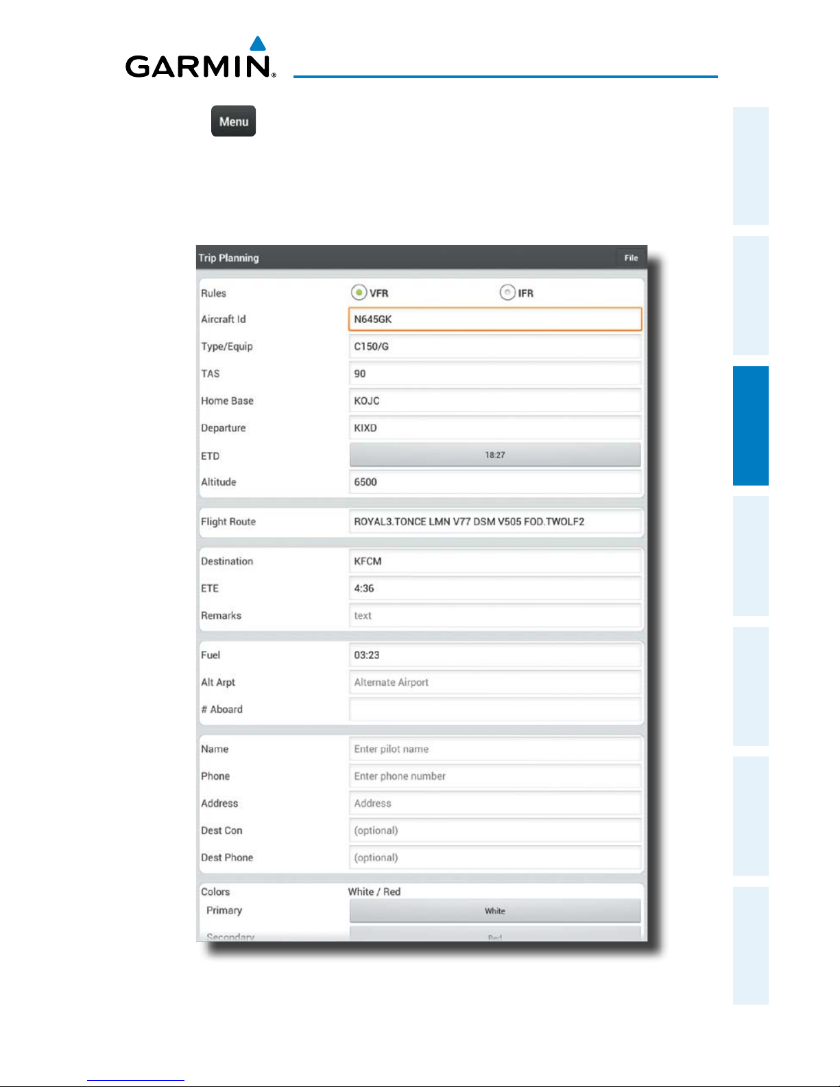
Garmin Pilot for Android User’s Guide
190-01532-00 Rev. A
71
File
Overview Plan File Fly Subscriptions Appendices Index
Or:
Tap > Close This Plan.
3)
Confirm the information is correct (Aircraft, ETD and route must match).
Tap Close in the upper right corner. A notification window will appear
providing flight plan close confirmation.
File Flight Plan Form
Page 88
Garmin Pilot for Android User’s Guide
190-01532-00 Rev. A
72
File
OverviewPlanFileFlySubscriptionsAppendicesIndex
Blank Page
Page 89
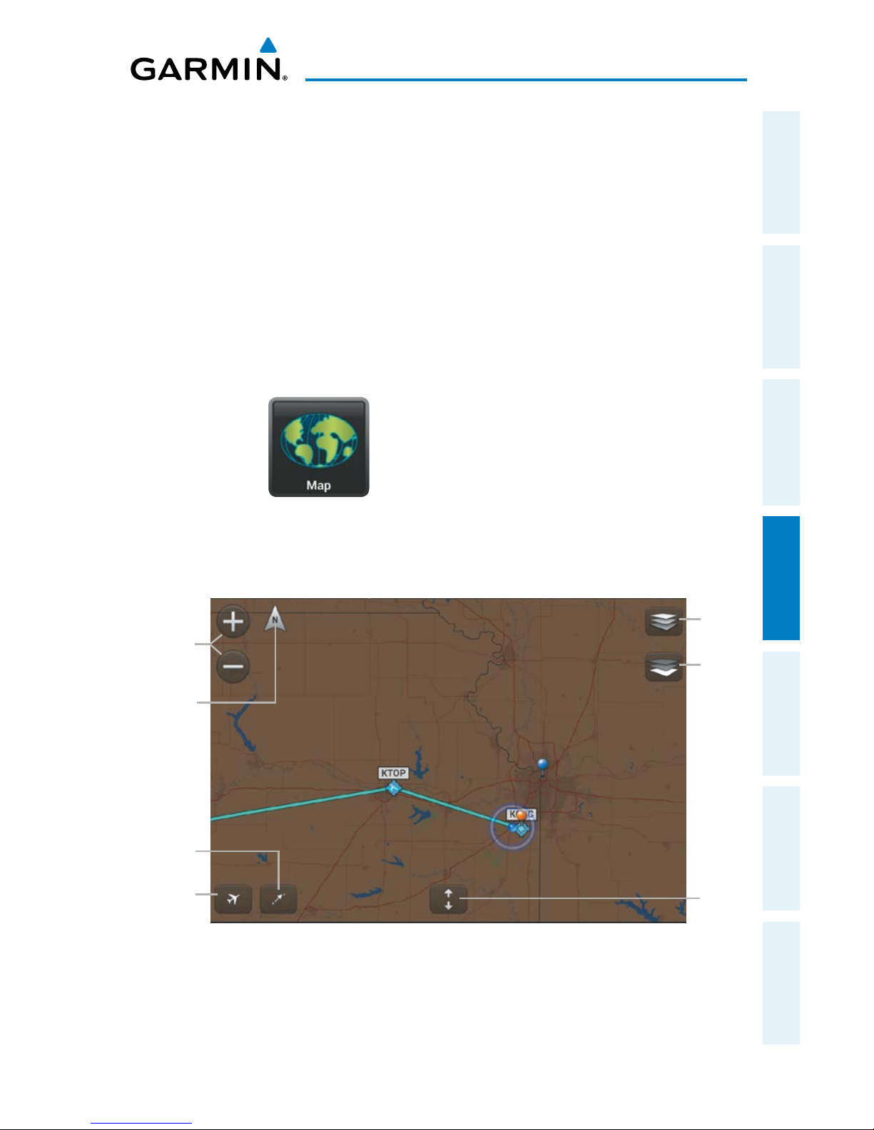
Garmin Pilot for Android User’s Guide
190-01532-00 Rev. A
73
Fly
Overview Plan File Fly Subscriptions Appendices Index
FLY
Garmin Pilot provides full en-route navigation capabilities on its moving map.
The ability to view navigation data such as ETE, ETA, crosstrack error, and distance
information. Long press any location on the map and the Radial Menu provides quick
and easy access to navigation information, including airports, navaids, and METARs.
The Radial Menu also provides a ready means of navigating direct-to, creating user
waypoints or graphically editing the route of flight. After takeoff, pilots can continue
to view updated weather information via a GDL 39 (sold separately) or by connecting
to SiriusXM Weather through the Baron Mobile Link™ paired with a satellite weather
receiver (sold separately, subscription required).
MAP PAGE
The Map Page is comprised of Map Pane and an option for split-screen. The Splitscreen option allows the Map Page to be divided between the Map Pane and Widgets,
The Split-screen feature is available in either portrait or landscape screen orientation.
Map Pane
SplitScreen
Layer
Select
Center on
Aircraft
Center
on Route
Zoom
In/Out
Basemap
Select
Map
Orientation
Page 90
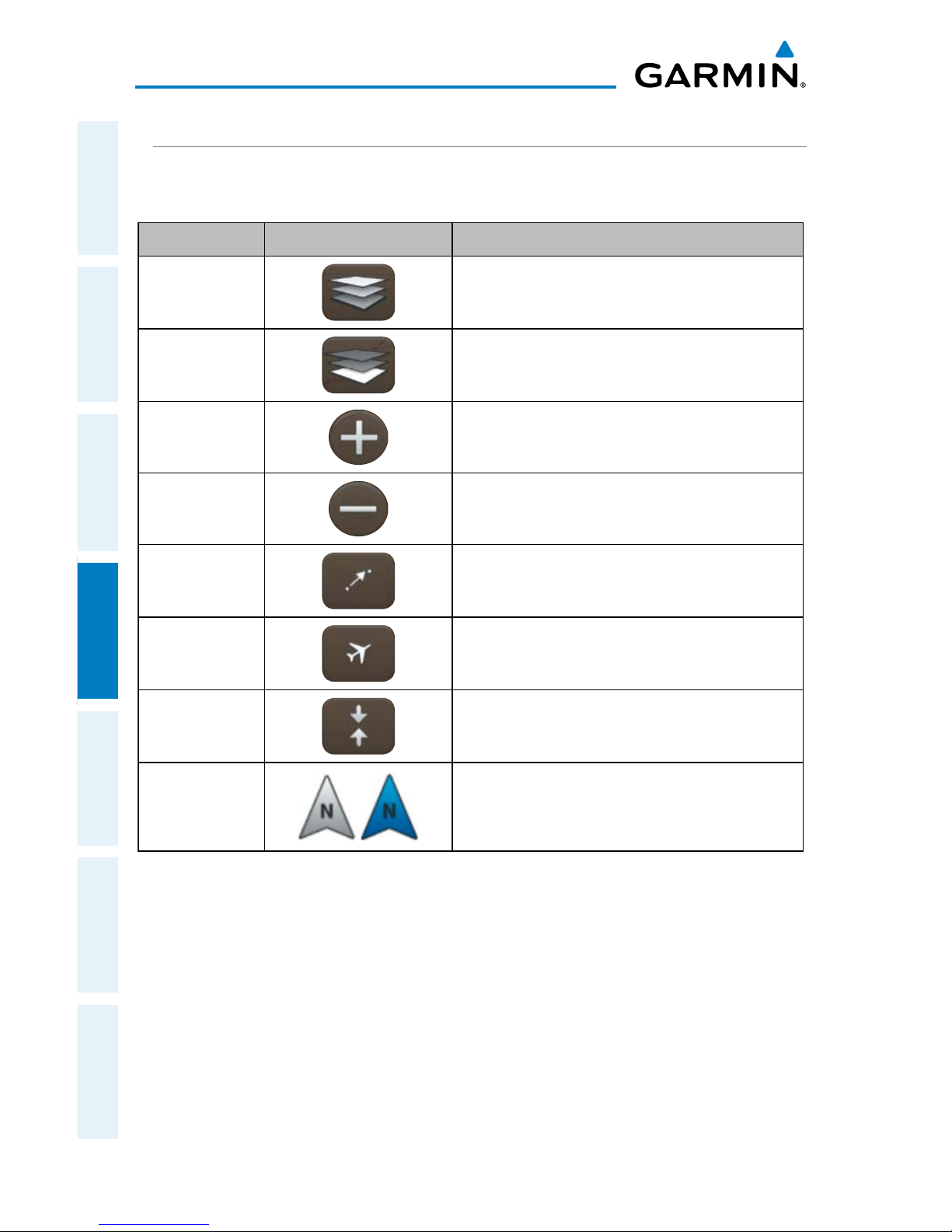
Garmin Pilot for Android User’s Guide
190-01532-00 Rev. A
74
Fly
OverviewPlanFileFlySubscriptionsAppendicesIndex
MAP PANE CONTROLS
The Map Pane has a number of buttons that control the Base Map, Map Overlays
and center map and split-screen. The table below shows the Map Pane Controls.
Control Icon Description
Layer Select
Opens Map Overlay menu
Basemap
Select
Opens Basemap selection menu
Zoom In
Zooms In on the map
Zoom Out
Zooms out on the map
Center on
Route
Centers the entire route in Map Pane.
Center on
Aircraft
Centers the Map Pane on the current
location.
Split-Screen
Selects full screen map or partial map with
Widgets, Panel, Charts, and SafeTaxi.
Map
Orientation
Toggles map orientation from north up to
track up. The Icon is blue when track up is
active.
Map Pane Controls
Page 91
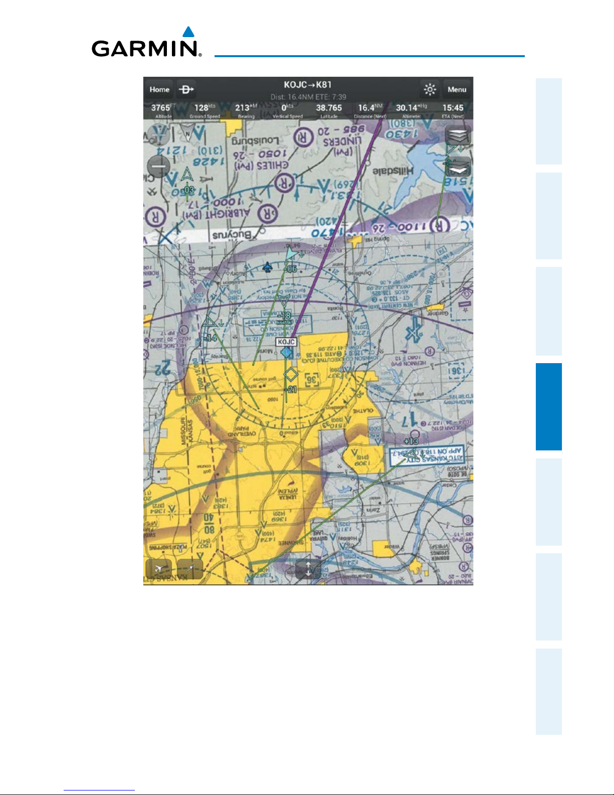
Garmin Pilot for Android User’s Guide
190-01532-00 Rev. A
75
Fly
Overview Plan File Fly Subscriptions Appendices Index
Track Up Map Orientation
Page 92
Garmin Pilot for Android User’s Guide
190-01532-00 Rev. A
76
Fly
OverviewPlanFileFlySubscriptionsAppendicesIndex
Selecting a Base Map:
1)
From any page tap > .
2)
Tap
and select the desired Base Map (i.e., VFR Sectionals, VFR WAC, IFR
Enroute (low), IFR Enroute (high), or Roads & Borders).
Map Panning:
1)
From any page tap > .
2)
Tap
and drag within the Map Pane to pan the map to the desired area.
3) Tap to center the Map Pane over the route of flight
4) Tap to center the Map Pane over the current location.
NAV BAR
The available Nav Bar provides user selectable navigation and weather data
displayed at the top of the map pane.
Nav Bar Field Options:
•Altitude
•Bearing
•Course
•CrossTrackError
•Distance(Dest)
•Distance(Next)
•ETA(Dest)
•ETA(Next)
•ETE(Dest)
•ETE(Next)
•GroundSpeed
•Latitude
•Longitude
•NextWaypoint
•Time
•Track
•VerticalSpeed
•Wx-Wind
•Wx-Visibility
•Wx-Altimeter
•Wx-Ceiling
Page 93
Garmin Pilot for Android User’s Guide
190-01532-00 Rev. A
77
Fly
Overview Plan File Fly Subscriptions Appendices Index
MAP ZOOM
Garmin Pilot Features VFR sectional IntelliZoom. When a more detailed map is
available, IntelliZoom automatically switches to the more detailed map as you continue
to zoom in. For example, if VFR WAC is the current Base Map, as you zoom in, the base
map detail will automatically change to VFR Sectional scale and detail. Continuing to
zoom in over an area that has a TAC chart, Garmin Pilot will continue to zoom in to TAC
scale, or the highest level of detail available for that area. When zooming out, the map
scale will return to the selected level. For example, if you zoom out on a VFR Sectional
Base Map, Garmin Pilot will not change to a VFR WAC scale.
Map Zooming:
1)
From any page tap > .
2)
Pinch fingers together (zoom out), or pull fingers apart or double-tap (zoom
in).
Or:
Use the Zoom In/Out Buttons or
Page 94
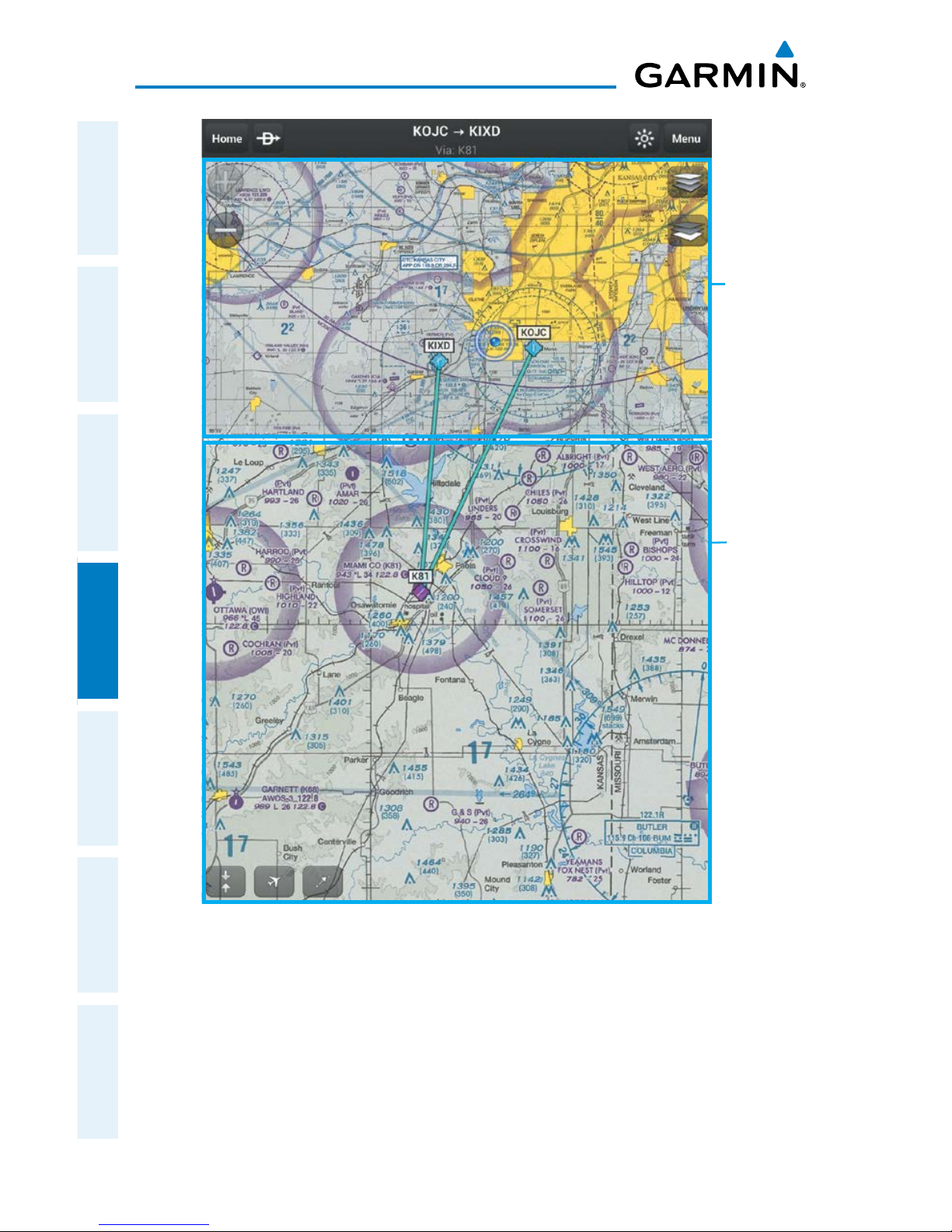
Garmin Pilot for Android User’s Guide
190-01532-00 Rev. A
78
Fly
OverviewPlanFileFlySubscriptionsAppendicesIndex
IntelliZoom
Map Pane
showing
TAC Detail
and Scale
Map Pane
showing
Sectional
Detail and
Scale
Page 95
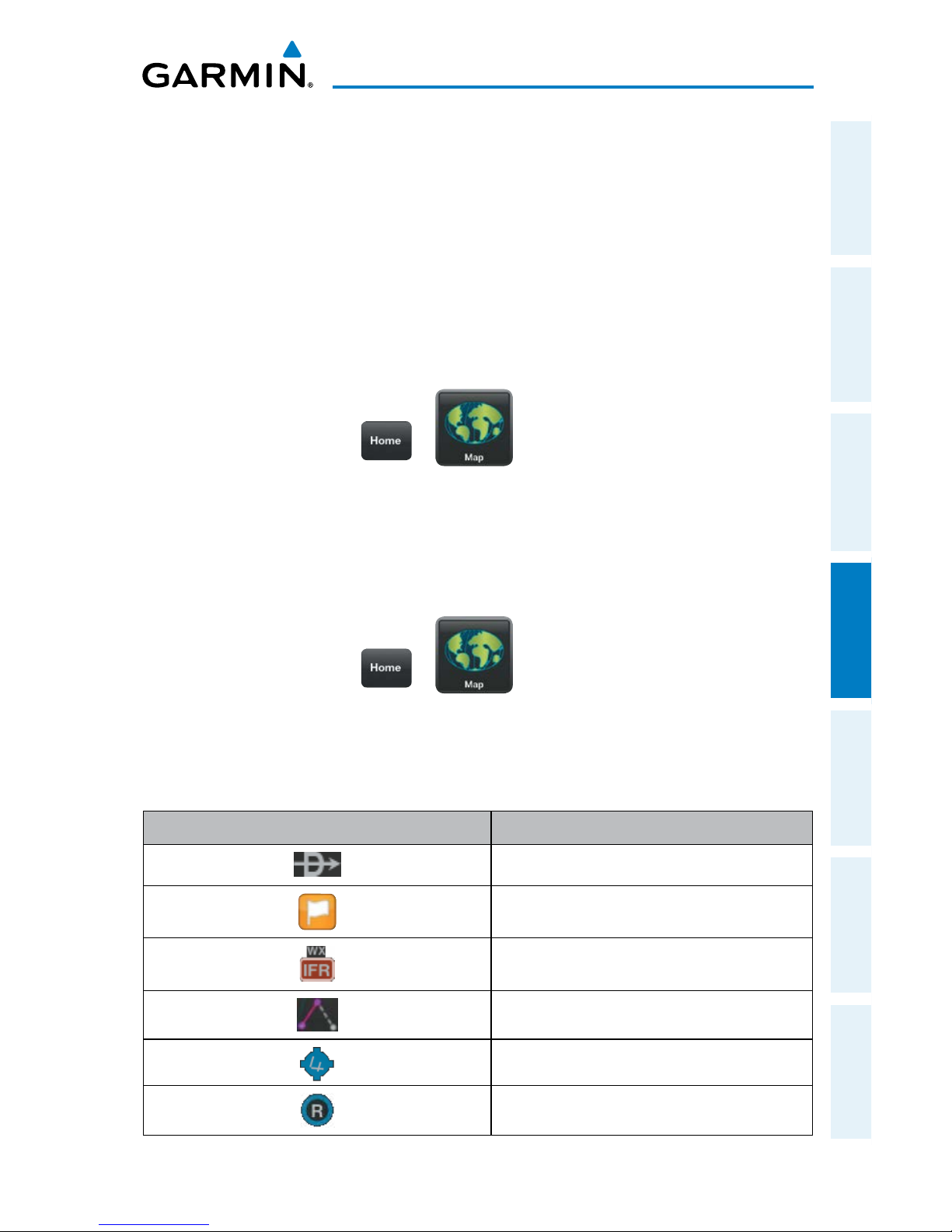
Garmin Pilot for Android User’s Guide
190-01532-00 Rev. A
79
Fly
Overview Plan File Fly Subscriptions Appendices Index
RADIAL MENU
The Radial Menu is accessed by long-pressing on the map. The Radial Menu displays
context-sensitive buttons for information found within the inner radius of the menu. The
context sensitive buttons provide details for airports, navaids, and weather stations. No
matter where the Radial Menu appears, it will always provide the option to navigate direct
to the location or create a user waypoint. To reposition the Radial Menu, simply touchdrag it to a new location.
Accessing the Radial Menu:
1)
From any page tap > .
2)
Long press on the desired area in the Map Pane until the Radial Menu
appears.
3)
Tap anywhere outside of the Radial Menu to exit.
Repositioning the Radial Menu:
1)
From any page tap > .
2)
Long press in the Map Pane until the Radial Menu appears.
3)
Once the Radial Menu appears, touch and drag the Radial Menu to
reposition over a new area.
Radial Menu Symbol Description
Navigate Direct-to
Create User Waypoint
Weather Observation Condition
Graphically Edit Route
Towered, Serviced Airport
Towered, Private Airport
Page 96
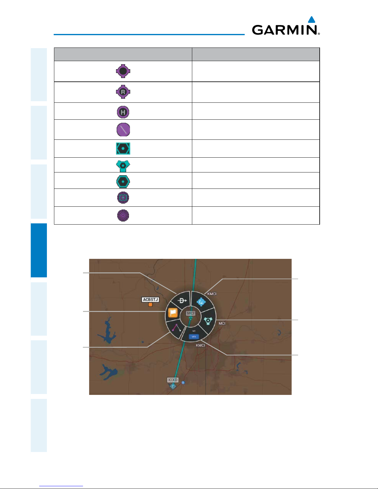
Garmin Pilot for Android User’s Guide
190-01532-00 Rev. A
80
Fly
OverviewPlanFileFlySubscriptionsAppendicesIndex
Radial Menu Symbol Description
Public Soft Surface, Serviced Airport
Private Soft Surface, Serviced Airport
Heliport
Solid Surface Airport, No Services
VOR/DME
VORTAC
VOR
NDB/DME
NDB
Radial Menu Symbols
Radial Menu
Airport
Info
Direct-
to
Create
User
Waypoint
Weather
Info
Navaid
Info
Graphically
Edit Route
Page 97
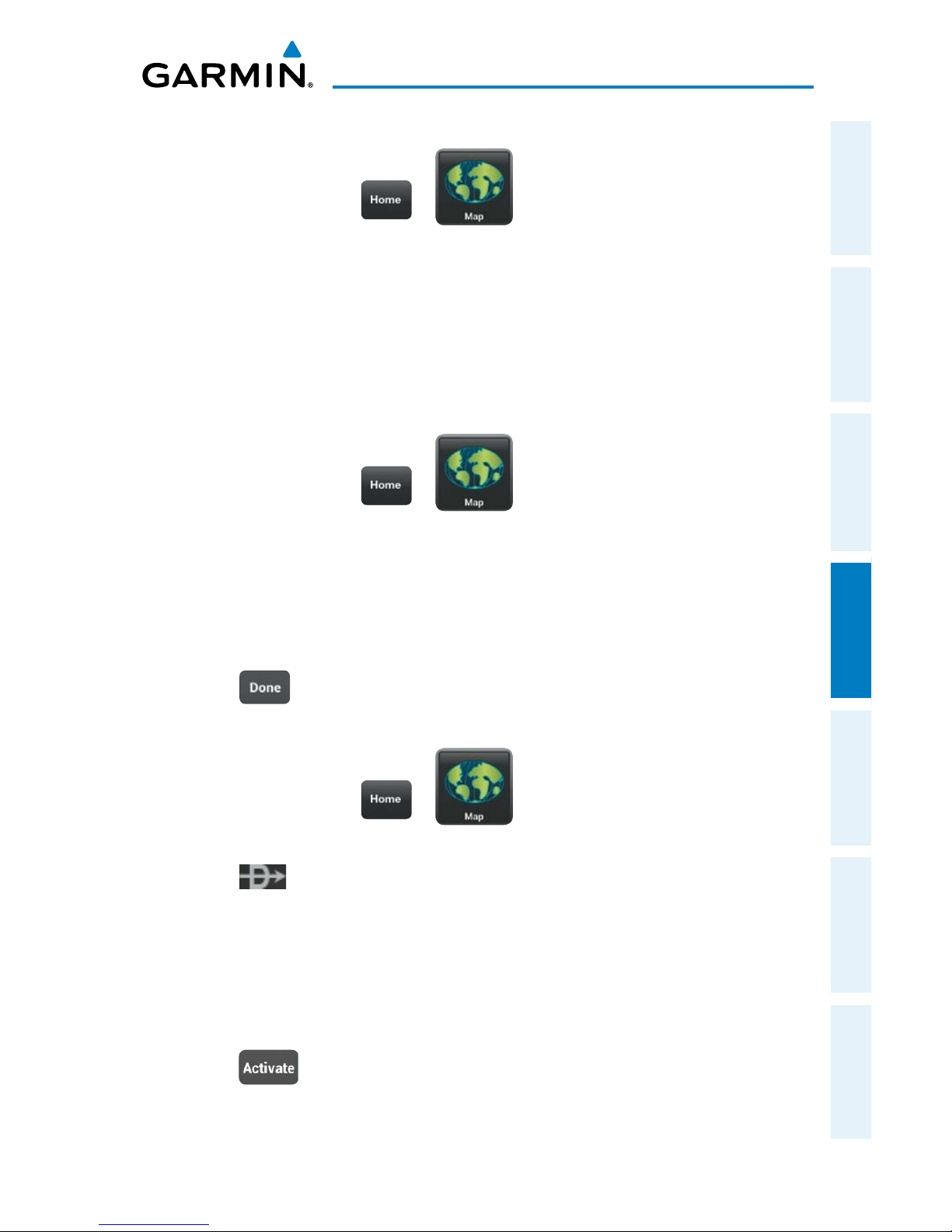
Garmin Pilot for Android User’s Guide
190-01532-00 Rev. A
81
Fly
Overview Plan File Fly Subscriptions Appendices Index
Viewing Navaid, or Weather Information:
1)
From any page tap > .
2)
Long press on the desired area in the Map Pane until the Radial Menu
appears.
3)
Tap the desired menu icon.
4)
Tap outside of the dialog box to close.
5)
Tap outside of the Radial Menu to exit.
Viewing Airport Information from the Radial Menu:
1)
From any page tap > .
2)
Long press near the desired Airport in the Map Pane until the Radial Menu
appears.
3)
Tap the Airport icon.
4)
The Airport information window will always show the 'General' information,
select 'Freq', 'Runways', or 'Fuel' to view more information.
5)
Tap or outside of the dialog box to exit.
Navigating Direct To Using the Radial Menu:
1)
From any page tap > .
2)
Long press the desired area in the Map Pane until the Radial Menu appears.
3)
Tap .
4)
Within the Direct-to... dialog window, select 'Map-Touch' to create a
temporary waypoint at the selected point, or choose one of the nearby
Navigation Database features from the list.
Or:
Choose a waypoint from one of the other tabs
(i.e., Waypoints, Flight Plan,
or Nearest).
5) Tap to begin navigation.
Page 98
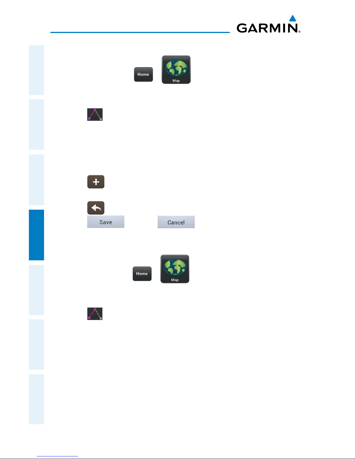
Garmin Pilot for Android User’s Guide
190-01532-00 Rev. A
82
Fly
OverviewPlanFileFlySubscriptionsAppendicesIndex
Graphically Edit Route:
1)
From any page, tap > .
2)
In the Map Pane, long press any flight plan waypoint or flight plan leg until
the Radial Menu appears.
3)
Tap to graphically edit the flight plan. The Radial Menu disappears
and the 'Graphical Flight Plan Edit Mode' blue banner appears just below
the Control Bar.
4)
Long press a flight plan leg and drag, the flight plan leg to the desired
location. Select a waypoint from the list of nearby navigation database
waypoints, or create a User Waypoint.
Or:
Tap to start a new route.
5)
Repeat step four for each flight plan leg to edit.
6)
Tap to undo the most recent action.
7)
Tap to save or to cancel and exit Graphical Flight
Plan Editing Mode.
Graphically Edit SIDs or STARs:
1)
From any page tap > .
2)
In the Map Pane, long press any flight plan waypoint or flight plan leg until
the Radial Menu appears.
3)
Tap to graphically edit the flight plan. The Radial Menu disappears
and the 'Graphical Flight Plan Edit Mode' blue banner appears just below
the Control Bar.
4)
Long press on a SID/STAR flight plan leg or waypoint. The 'Change SID/
STAR' dialog box appears.
Page 99
Garmin Pilot for Android User’s Guide
190-01532-00 Rev. A
83
Fly
Overview Plan File Fly Subscriptions Appendices Index
5)
Tap Delete SID/STAR to delete or select an alternate SID/STAR from the list
and then selecting the desired transition from the submenu. If the selected
flight plan leg is the first leg of a SID, the dialog box will allow you to delete
the departure point. If the departure point is deleted, the departure point
and all waypoints associated with the SID are removed from the flight plan.
The first waypoint after the SID becomes the departure point.
6)
Tap to undo the most recent action.
7)
Tap to save or to cancel and exit Graphical Flight
Plan Editing Mode.
Page 100
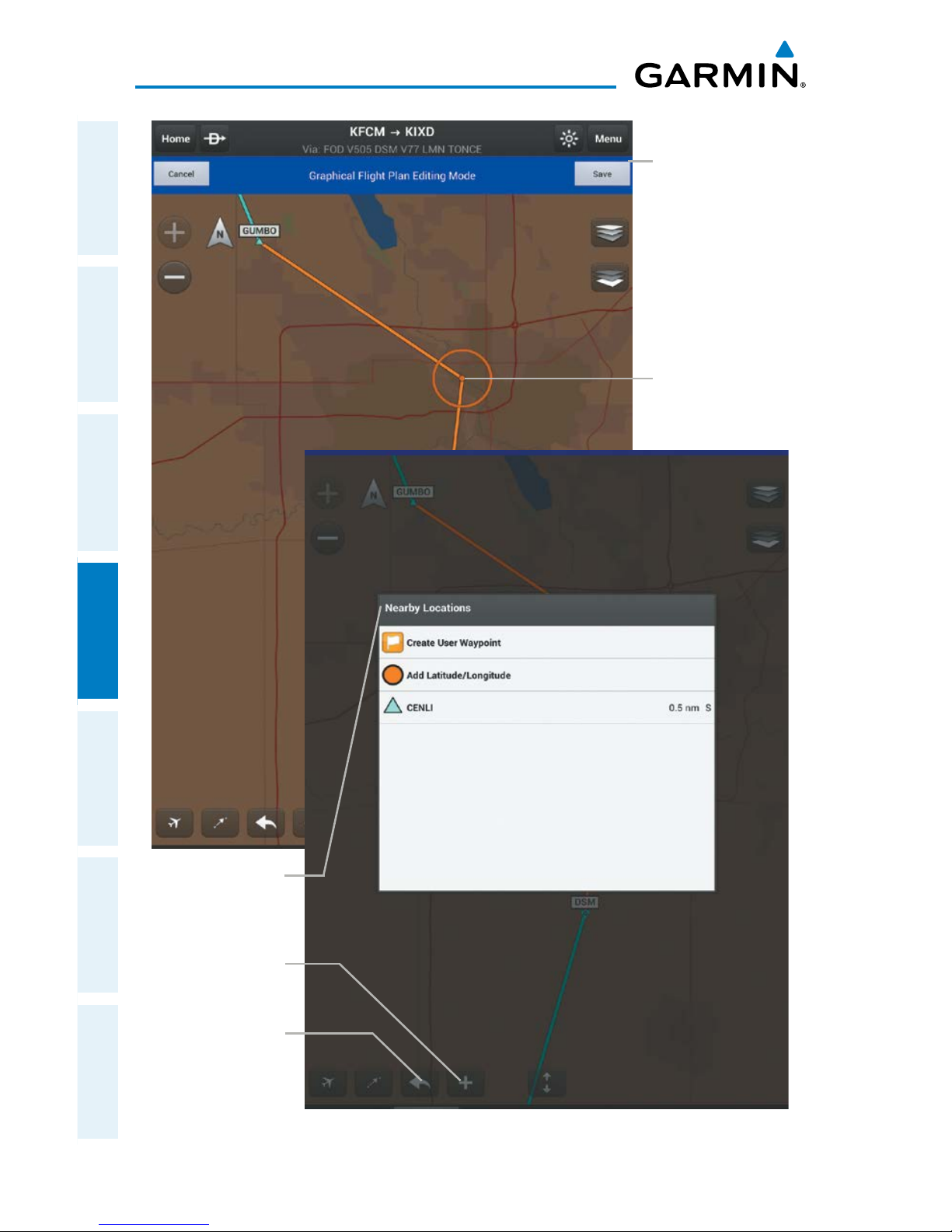
Garmin Pilot for Android User’s Guide
190-01532-00 Rev. A
84
Fly
OverviewPlanFileFlySubscriptionsAppendicesIndex
Graphical Flight Plan Editing
Rubber
Band
Nearby
Locations
Graphical
Flight Plan
Editing Mode
Save or Cancel
Start New
Flight
Plan
Undo
Button
 Loading...