

Page 1
GND™ 10 Installation Instructions
This device bridges the connection between Nexus® network
devices and a NMEA 2000® network. When the device is
connected to a computer using the included USB cable, you can
calibrate advanced wind transducers such as the gWind Race™
using the NexusRace™ software, and you can use data from the
transducers with programs such as Expedition® and Adrena.
Important Safety Information
WARNING
See the Important Safety and Product Information guide in the
product box for product warnings and other important
information.
CAUTION
Always wear safety goggles, ear protection, and a dust mask
when drilling, cutting, or sanding.
NOTICE
When drilling or cutting, always check what is on the opposite
side of the surface.
If you are unfamiliar with NMEA 2000, you should read the
“NMEA 2000 Network Fundamentals” chapter of the Technical
Reference for NMEA 2000 Products. To download this
document, select Manuals on the product page for your device
at www.garmin.com.
Registering Your Device
Help us better support you by completing our online registration
today.
• Go to http://my.garmin.com.
• Keep the original sales receipt, or a photocopy, in a safe
place.
Mounting Considerations
NOTICE
This device should be mounted in a location that is not exposed
to extreme temperatures or conditions. The temperature range
for this device is listed in the product specifications. Extended
exposure to temperatures exceeding the specified temperature
range, in storage or operating conditions, may cause device
failure. Extreme-temperature-induced damage and related
consequences are not covered by the warranty.
When selecting a mounting location, observe these
considerations.
• To avoid interference with a magnetic compass, the device
should not be installed closer to a compass than the
compass-safe distance value listed in the product
specifications.
• You can use the included screws to mount the device on
your boat. If the included screws are not appropriate for the
mounting surface, suitable hardware must be purchased
separately.
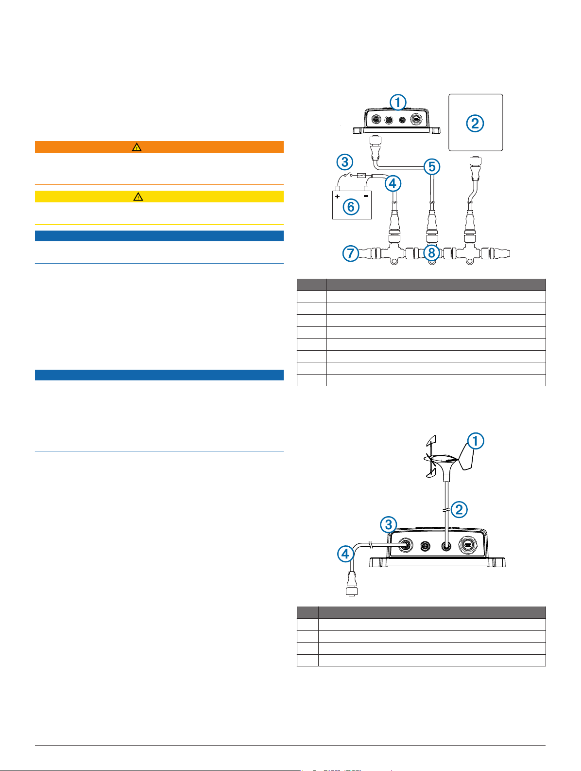
Item Description
À
Á
Â
Ã
Ä
Å
Æ
Ç
GND 10 device
Garmin® marine instrument
Ignition or in-line switch
NMEA 2000 power cable
NMEA 2000 drop cable
12 Vdc power source
NMEA 2000 terminator or backbone cable
NMEA 2000 T-connector
Nexus Connection Considerations
You must connect a Nexus network device to one of the
NEXUS ports.
Mounting the Device
Determine the mounting location.
1
Using the device as a template, mark the two pilot hole
2
locations on the mounting surface.
Using a 1/8 in. (3 mm) bit, drill the pilot holes.
3
Use the included screws to attach the device to the mounting
4
surface.
Connection Considerations
NMEA 2000 Connection Considerations
This device connects to a NMEA 2000 network on your boat to
share information from connected Nexus network devices.
2
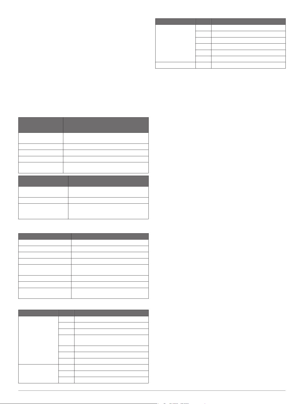
Item Description
Nexus network device, such as a gWind™ sensor
À
Included Nexus mast cable with a field-installable connector.
Á
GND 10
Â
NMEA 2000 drop cable
Ã
Connecting to a Computer
When the device is connected to a computer using the included
USB cable, you can calibrate advanced sensors such as the
gWind Race using the NexusRace software. You can also use
data from connected wind transducers with third-party sailing
programs such as Expedition and Adrena.
Page 2
Connect the included USB cable to the USB port on the
1
device.
Connect the other end of the USB cable to an open USB port
2
on your computer.
The LED near the USB port flashes green when the device is
correctly connected to your computer.
The correct driver should be installed automatically by the
Windows® operating system.
If the correct driver is not installed automatically, download
3
and install the driver from www.garmin.com.
After the device is connected correctly to the computer,
4
download the NexusRace software from www.garmin.com
and install it.
Status LEDs
The status LEDs are located on the product label near the ports
and can help when troubleshooting problems.
NMEA 2000 Status
LED Color and
Activity
Off There is no power over the NMEA 2000
Solid red The device is turning on.
Flashing green The device is operating properly.
Flashing orange The device software is being updated.
Flashing red The device has encountered an error. Contact
Status
network.
Garmin product support for assistance.
Type PGN Description
130306 Wind data
130310 Environmental parameters
130311 Environmental parameters
130312 Temperature
130314 Actual pressure
130316 Temperature, extended range
Receive 065240 ISO commanded address
NEXUS and USB Status
LED Color and Activity
Flashing green The connected device is operating
Flashing orange The connected device is initializing.
Flashing red The connected device has encountered an
Status
properly.
error. Contact Garmin product support for
assistance.
Specifications
Specification Measurement
Dimensions (H×W×D) 170 x 90 x 50 mm (6.7 x 3.5 x 2 in.)
Weight 196 g (6.9 oz.)
Temperature range From 5° to 158°F (from -15° to 70°C)
Compass-safe distance 10 cm (3.9 in.)
Waterproof rating IPX7 (protected against water immersion
Power usage 0.85 W max.
NMEA 2000 input voltage From 9 to 16 Vdc
NMEA 2000 load
equivalency number (LEN)
NMEA 2000 PGN Information
Type PGN Description
Transmit and receive 059392 ISO acknowledgment
Transmit 126996 Product information
for 30 minutes at a depth of 1 m (3 ft.))
4 (200 mA at 9 Vdc)
059904 ISO request
060928 ISO address claim
126208 Command, request, and acknowledge
group function
129026 COG and SOG : Rapid update
129029 GNSS position data
129540 GNSS satellites in view
127250 Vessel heading
128259 Speed: Water referenced
3
Page 3
The GND10
The GND10 is a converter form Nexus Network to NMEA2000 (used for Garmin and
other manufacturer). Most of the data is converted both ways from Nexus to NMEA2000
and NMEA2000 to Nexus.
The GND10 is delivered with the default settings where all preferred sources are from
the NMEA2000 to the Nexus Network. If you have an existing Nexus Network with
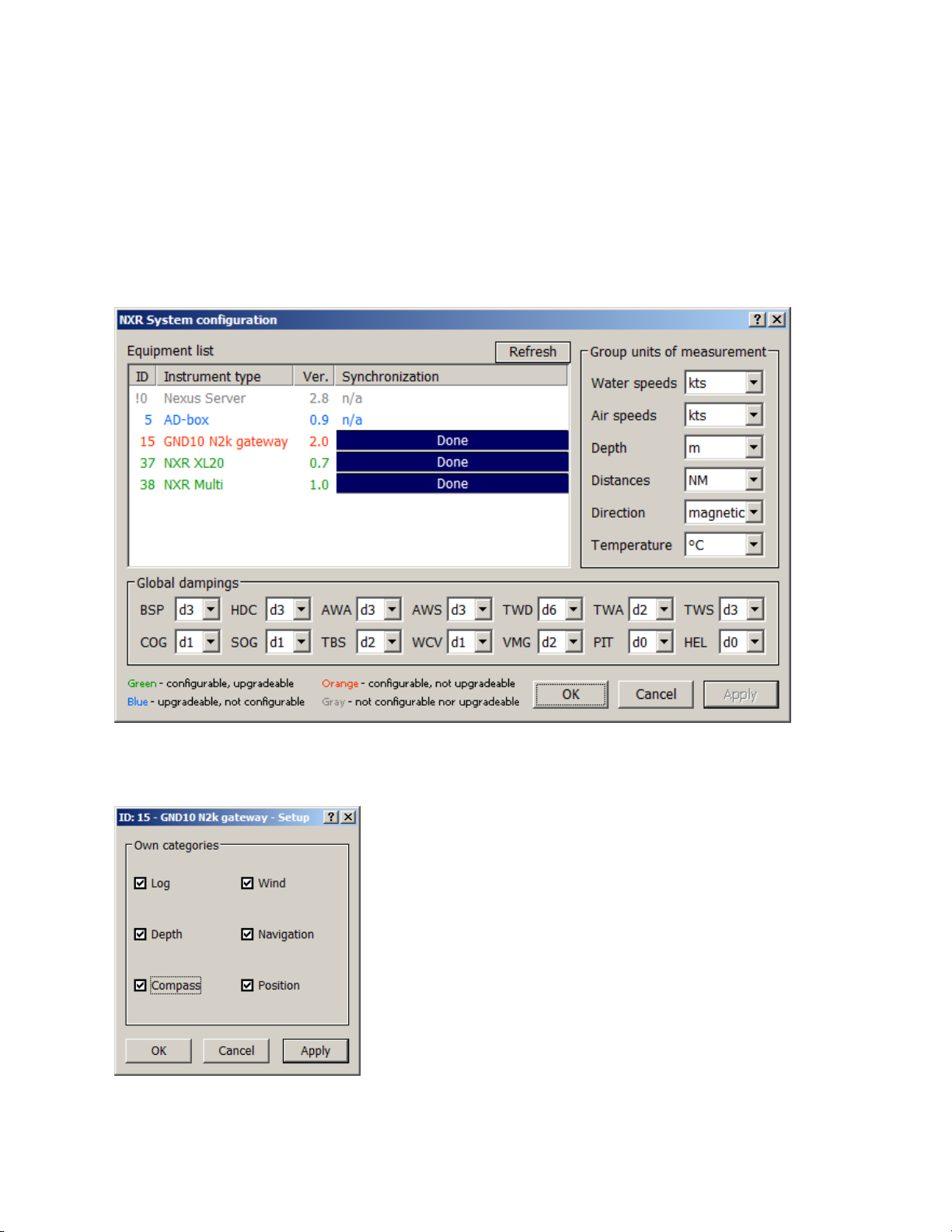
Nexus transducers, you have to change the preferred sources. Select Tools and
Configure and a list of your Nexus Network components are showed:
To change preferred sources for the GND, double click on the GND N2k gateway in the
list.
As you can see all tick boxes are checked and the GND10 will convert NMEA2000 data
and send it out on the Nexus Network. For the transducers/functions you want the
Nexus Network to provide for, un-check the equivalent box:
Page 4
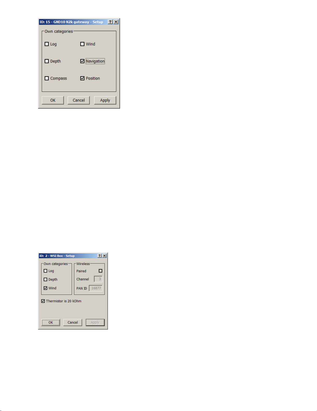
In the example above, a NX2 Server is used and the Log, Depth, Wind and Compass
will all come from the Nexus transducers. GPS Position and Navigation data will come
from the NMEA2000 network and be send out on the Nexus Network. Log, Depth, Wind
and Compass will be send out on the NMEA2000 network from the GND10.
Note:
If a nWind transducer, a HPC Compass or a nGPS antenna. Is connected, they will
always send out the data on the Nexus Network. If you have a nGPS antenna and want
the position data from the NMEA2000 GPS to be used in the Nexus syste, you have to
physically disconnect the nGPS (the same goes for nWind and HPC Compass)
The WSI-box will also be responsible for Log, Depth and Wind on the Nexus Network
unless these functions are un-checked in the WSI-setup box
This WSI-box will only provide Wind information on the Nexus Network!
Install the NexusRace SW
First you download the driver for the GND10:
Page 5
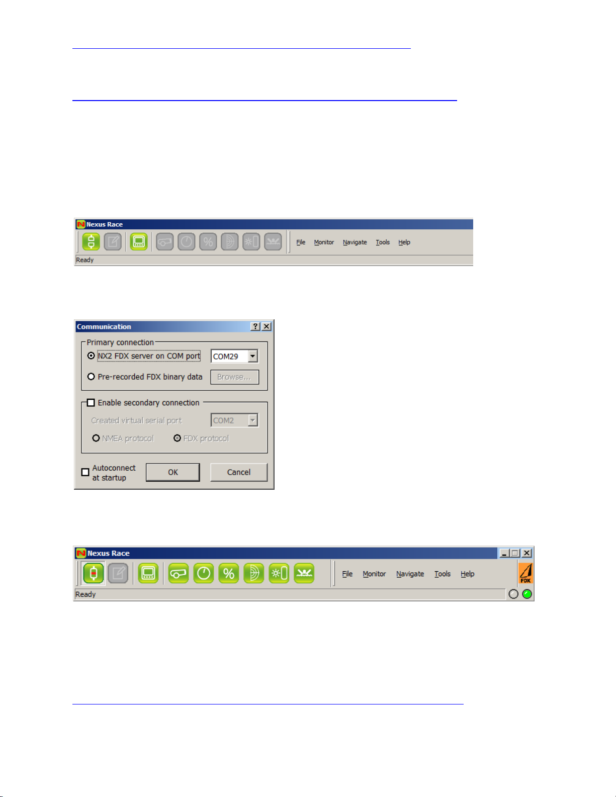
http://www8.garmin.com/support/download_details.jsp?id=6889
Then you download and install the NexusRace SW:
http://www8.garmin.com/support/download_details.jsp?id=6885#Instruct
Run the NexusRace SW
When you start NexusRace, you have to connect it to the GND10.
Press the Connection icon in the top left corner of the tool bar:
Select the comport the GND10 has created. The comport no is displayed during the
installation but if you did not see that, it is normally the last comport in the list.
Press OK and after a couple of seconds, the green connection LED lights up in the top
right corner.
Now you are connected to the GND10 and you can monitor data and more.
For a full user manual of the NexusRace SW, follow this link:
http://www.nexusmarine.se/wp-content/uploads/2011/11/FDX-Manual.pdf
Page 6
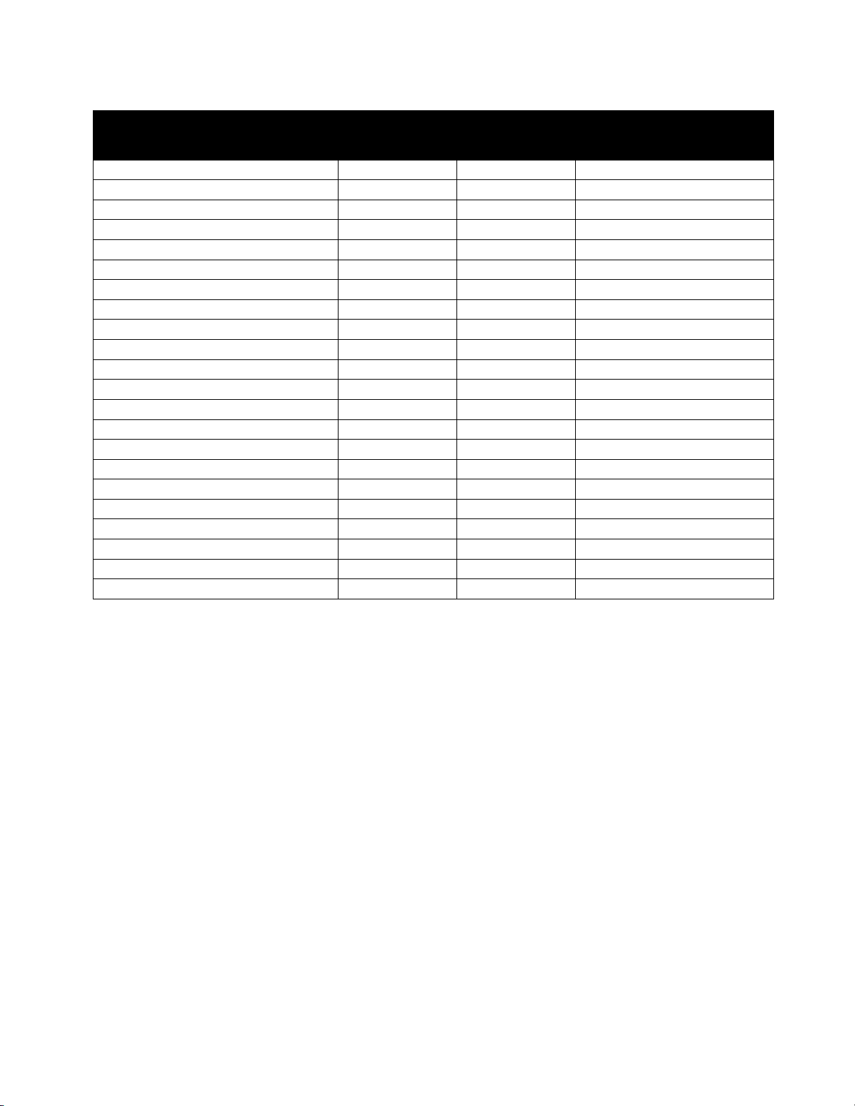
Full list of data that is translated by the GND10
Data
Nexus to
NMEA2000
NMEA2000
to Nexus
Comment
Apparent Wind Angle
Y
Apparent Wind Speed
Y
Boat Speed Through Water
Y
Y
See Note 1
Course Over Ground
Y
See Note 3
Course to Waypoint
Y
Cross Track Error
Y
Depth Y Y
See Note 2
Distance to Waypoint
Y
Latitude Y
See Note 3
Longitude
Y
See Note 3
Magnetic Heading
Y
Y
See Note 4
Magnetic Variation
Y
Speed Over Ground
Y
See Note 3
True Heading
Y
Y
See Note 4
True Wind Angle
Y
True Wind Speed
Y
UTC Date
Y
See Note 7
UTC Time
Y
See Note 7
Water Temperature
Y
Y
See Note 5
Barometric Pressure
Y
See Note 6
Note 1: If a WSI box is used on the Nexus Side, it will not automatically hand over the responsibility to
send speed out on the Nexus Network to the GND10 unless this categories are disabled in the WSI-box.
Only boat speed and Maximum boat speed will work in the Nexus Network. Trip, Log and average speed
will not work!
Note 2: If a WSI box is used on the Nexus Side, it will not automatically hand over the responsibility to
send depth out on the Nexus Network to the GND10 unless this categories are disabled in the WSI-box.
Only will work in the Nexus Network. Shallow and Deep alarm will not work!
Note 3: If a nGPS Antenna is connected to the Nexus Network, it will not hand over the responsibility for
Position, SOG and COG to the GND10. The nGPS will always send position related data as long as it is
connected. To get position data from the GND10 to the Nexus Network, the nGPS has to be
disconnected from the Nexus Network. If a NMEA0183 Antenna is connected to the Nexus Server, the
data will come from NMEA2000 (via the GND10) if the tick box for Position is checked for the GND10
Note 4: If a HPC Compass is connected to the Nexus Network, it will not hand over the responsibility
Heading. The HPC Compass will always send Heading related data as long as it is connected. To get
Heading data from the GND10 to the Nexus Network, the HPC has to be disconnected from the Nexus
Network. If a 35 or 45 degree Compass is connected to the Nexus Server, the data will come from
NMEA2000 (via the GND10) if the tick box for Heading is checked for the GND10
Note 5: The selection if Water temp should come from NMEA2000 (via the GND10) and be send out on
the Nexus Network is determined by the tick box for Log is checked for the GND10
Note 6: Barometric Pressure is send from the Wireless Wind and WSI box. The wired wind sensor does
not provide this information
Page 7
Note 7: The time is transferred from the NMEA2000 via the GND10 to the Nexus Network. Also the time
zone is send. However, the time zone is always -5h (Olathe time) and right now it cannot be changed.
How to select the direction of data conversion
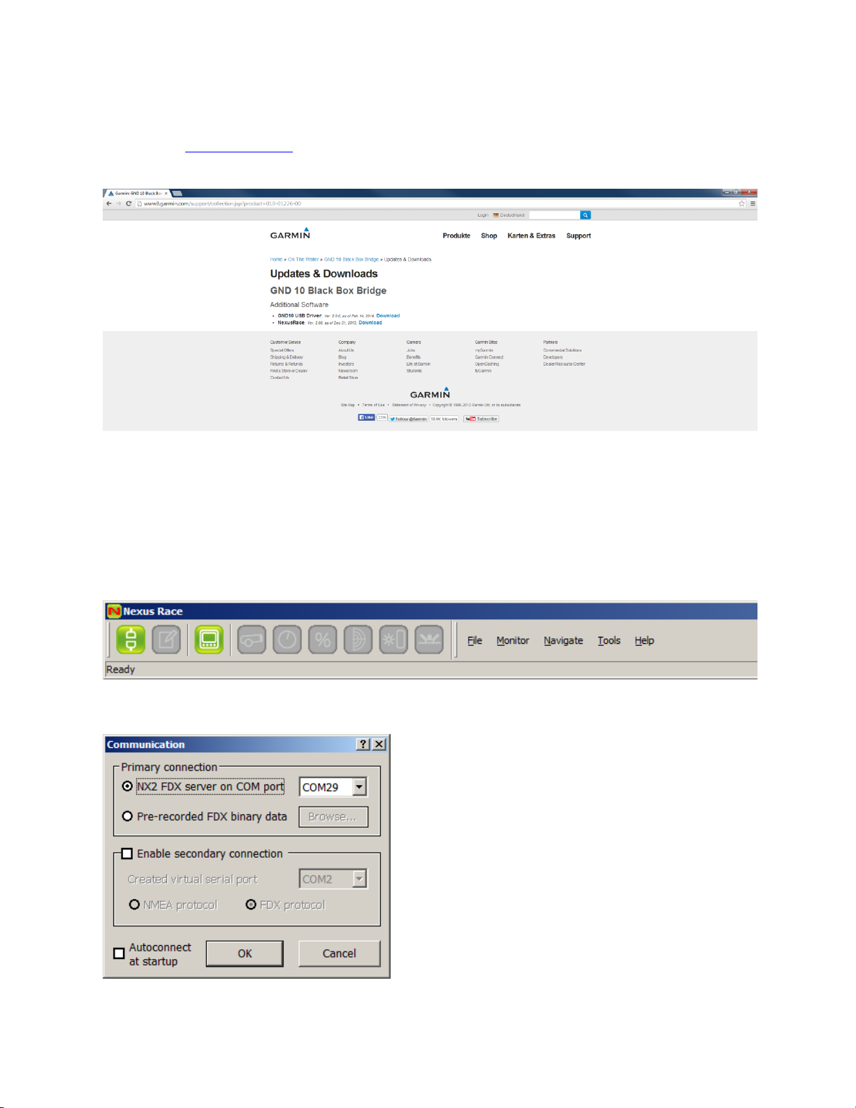
1. Goto www.garmin.com and the GND10
2. Go to Software and install the drivers and the NexusRace SW
3. Connect the GND10 and connect the USB connector to your PC
4. The GND10 will be installed and you will see what Comport it was assagned
5. Start the NexusRace Software
6. Click on the Connect icon
7. Select the COM-port the USB got assigned (If you do not know, it is normally the last in the list)
Page 8
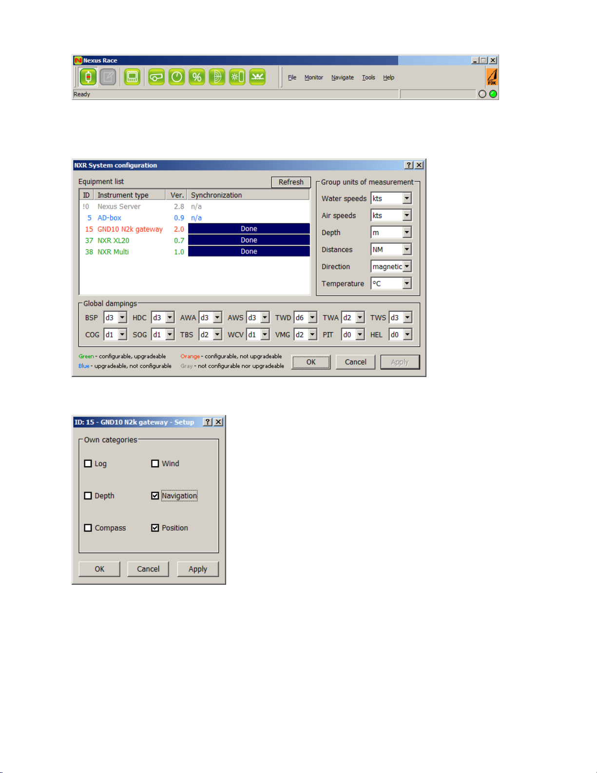
8. You are now connected
9. Click on Tools/Configre
10. A list of all Network units is displayed
11. Double click on the GND10 N2k gateway
Page 9
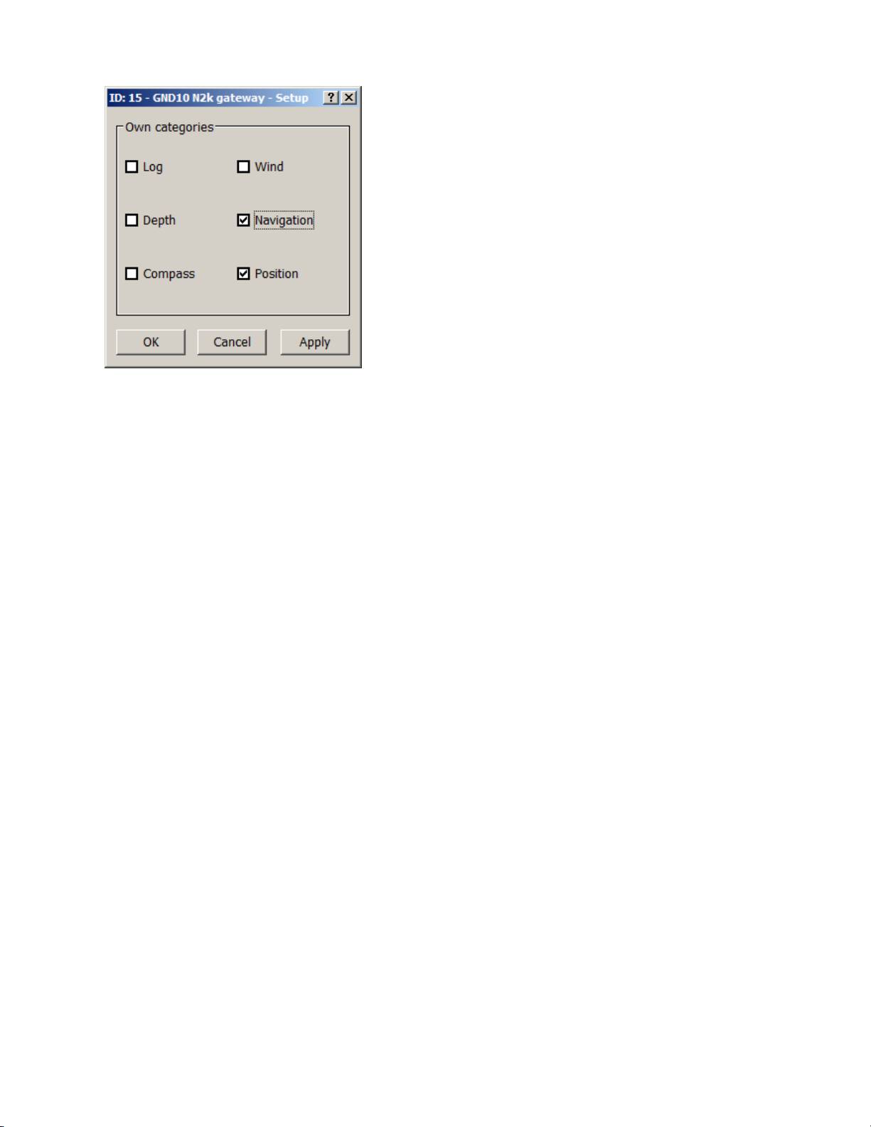
Settings for the GND10
If a box is checked, the data will go from NMEA 2000 to Nexus Network. If a box is unchecked, the data
will go from Nexus Network to NMEA2000
 Loading...