

Garmin 92 Pilot's Guide
GPS 92
GPS 92
OwnerÕs
Manual &
Reference


Software Version 2.01 or above
© 1998 GARMIN Corporation, 1200 E. 151st Street, Olathe, KS USA 66062
Tel: 913-397-8200 Fax: 913-397-8282
GARMIN (Europe) LTD, Unit 5, The Quadrangle, Abbey Park Industrial Estate,
Romsey, U.K. SO51 9AQ
Tel: 011-44-1794-519944 Fax: 011-44-1794-519222
GARMIN (Asia) Corp., 4th Fl., No. 1, Lane 45, Pao-Hsing Road, Hsin Tien,
Taiwan R.O.C.
Tel: 011-886-02-917-3773 Fax: 011-886-02-917-1758
Web Site Address: www.garmin.com
All rights reserved. No part of this manual may be reproduced or transmitted in
any form or by any means, electronic or manual, including photocopying and recording, for any purpose without the expressed written permission of GARMIN.
Information in this document is subject to change without notice. GARMIN
reserves the right to change or improve its products and to make changes in the content without obligation to notify any person or organization of such changes or
improvements.
GARMIN, AutoLocate, AutoStore, AutoZoom, PhaseTrac12, and TracBack are all
trademarks of GARMIN Corporation and may not be used without the expressed permission of GARMIN.
April 1998 Part #190-00153-00 Rev. A Printed in Taiwan.
i

GARMIN LIMITED WARRANTY
GARMIN warrants this product to be free from defects in materials and workmanship for one year from the date of purchase. GARMIN will at its sole option,
repair or replace any components which fail in normal use. Such repairs or replacement will be made at no charge to the customer for parts or labor. The customer is,
however, responsible for any transportation costs. This warranty does not cover failures due to abuse, misuse, accident or unauthorized alteration or repairs. GARMIN
assumes no responsibility for special, incidental, punitive or consequential damages,
or loss of use.
The warranties and remedies contained herein are exclusive and in lieu of all
other warranties expressed or implied, including any liability arising under warranty of merchantability or fitness for a particular purpose, statutory or otherwise. This
warranty gives you specific legal rights, which may vary from state to state.
To obtain warranty service, call the GARMIN Customer Service department for a
returned merchandise tracking number. The unit should be securely packaged with
the tracking number clearly marked on the outside of the package, and sent freight
prepaid and insured to a GARMIN warranty service station. A copy of the original
sales receipt is required as the proof of purchase for warranty repairs.
Once your standard warranty expires, GARMIN’s flat rate service policy provides
a low-cost, fast-turnaround factory repair for three additional years. The flat rate is
set at the time of purchase, and costs you nothing until you need it. If your GPS
receiver should ever need service or repair, return it to a GARMIN service center.
The flat rate service policy applies to the original owner, and is void if the product exhibits any evidence of physical abuse, neglect or intentional damage determined at the sole discretion of GARMIN.
A copy of the original sales receipt is required to verify the service rate in effect
at the time of purchase. If a receipt is not available or not included with the unit, it
will be repaired at the current three-year flat rate.
Software and database updates are not included in the warranty or flat rate program. GARMIN may, however, change the operating software and/or database at its
discretion at no additional cost. Unit repair or replacement will be made at the sole
discretion of GARMIN.
ii

INTRODUCTION
Packing List
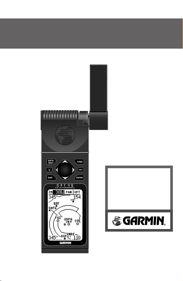
Thank you for choosing the GARMIN GPS 92—the best value in compact,
full-featured GPS navigation! The GPS 92 represents GARMIN’s continuing
commitment to provide a quality, affordable airborne navigation system you’ll
enjoy for years. To get the most out of your new GPS 92, take the time to read
through this owner’s manual in order to understand the operating features of
the unit. This manual is organized into three sections for your convenience.
Section One (Getting Started) introduces you to the basic features of the
unit and provides a quick-start orientation.
Section Two (Simulator Tour) provides a step-by-step lesson in how your
new GPS 92 would operate in actual flight by utilizing the built-in simulator.
Section Three (Reference) provides details for the advanced features of
your GPS 92 by topic. Use this section (and the Index) to review additional
information on GPS 92 features as the need arises.
Before getting started, check to see that your GARMIN GPS 92 package
includes the following items. If you are missing any parts, please contact your
dealer immediately.
• GPS 92 Unit
• Quick Reference Card
• Owner’s Manual
• Power/Data Cable
• Remote Antenna Mount
Cable w/ Suction Cup
• Detachable Antenna
• Carrying Strap
• Carrying Case
• ”AA” Alkaline Batteries (4)
iii

INTRODUCTION
Cautions
!
CAUTION: The GPS system is operated by the government of the United States,
which is solely responsible for its accuracy and maintenance. The system is subject to changes which could affect the accuracy and performance of all GPS
equipment. Although the GPS 92 is a precision electronic NAVigation AID
(NAVAID), any NAVAID can be misused or misinterpreted and therefore,
become unsafe.
Use the GPS 92 at your own risk. To reduce the risk of unsafe operation, carefully review and understand all aspects of this Owner’s Manual and thoroughly
practice operation using the simulator mode prior to actual use. When in actual
use, carefully compare indications from the GPS 92 to all available navigation
sources including the information from other NAVAIDs, visual sightings, charts,
etc. For safety, always resolve any discrepancies before continuing navigation.
NOTE: This device meets requirements for Part 15 of the FCC limits for Class B
digital devices for home or office use. It has been tested for compliance with all
necessary FCC standards. This equipment generates, uses, and can radiate radio
frequency energy and, if not installed and used in accordance with the instructions, may cause harmful interference to radio communications. However, there
is no guarantee that interference will not occur in a particular installation. If this
equipment does cause harmful interference to other equipment, which can be
determined by turning the equipment off and on, the user is encouraged to try
and correct the interference by relocating the equipment or connecting the
equipment to a different circuit than the affected equipment. Consult an authorized dealer or other qualified service technician for additional help if these
remedies do not correct the problem. Operation is subject to the following conditions: (1) This device cannot cause harmful interference, and (2) this device
must accept any interference received, including interference that may cause
undesired operation. The GPS 92 does not contain any user-serviceable parts.
Repairs should only be made by an authorized service center. Unauthorized
repairs or modifications could void your warranty and your authority to operate
this device under Part 15 regulations.
#
?
#
iv

INTRODUCTION
Table Of
Contents
Warranty . . . . . . . . . . . . . . . . . . . . . . . . . . . . . . . . . . . . . . . . . . . . .ii
Packing List . . . . . . . . . . . . . . . . . . . . . . . . . . . . . . . . . . . . . . . . . .iii
Cautions . . . . . . . . . . . . . . . . . . . . . . . . . . . . . . . . . . . . . . . . . . . .iv
SECTION ONE Getting Started
Unit Features . . . . . . . . . . . . . . . . . . . . . . . . . . . . . . . . . . . . . . . . . .3
Keypad Usage . . . . . . . . . . . . . . . . . . . . . . . . . . . . . . . . . . . . . . . . . .4
Battery/Antenna Installation . . . . . . . . . . . . . . . . . . . . . . . . . . . . . . . .5
What is GPS? . . . . . . . . . . . . . . . . . . . . . . . . . . . . . . . . . . . . . . . . . .6
Initializing the Receiver . . . . . . . . . . . . . . . . . . . . . . . . . . . . . . . . . . .7
Acquiring Satellites . . . . . . . . . . . . . . . . . . . . . . . . . . . . . . . . . . . . . .8
SECTION TWO GPS 92 Takeoff Tour
Power On . . . . . . . . . . . . . . . . . . . . . . . . . . . . . . . . . . . . . . . . . . . . .9
Page Sequence . . . . . . . . . . . . . . . . . . . . . . . . . . . . . . . . . . . . . . .9-10
Simulator Mode . . . . . . . . . . . . . . . . . . . . . . . . . . . . . . . . . . . . .10-11
Activating a GOTO . . . . . . . . . . . . . . . . . . . . . . . . . . . . . . . . . . . . .11
Navigation Page . . . . . . . . . . . . . . . . . . . . . . . . . . . . . . . . . . . . . . .12
Position Page . . . . . . . . . . . . . . . . . . . . . . . . . . . . . . . . . . . . . . . . .13
Moving Map Page . . . . . . . . . . . . . . . . . . . . . . . . . . . . . . . . . . .13-14
Airport Pages and SUAs . . . . . . . . . . . . . . . . . . . . . . . . . . . . . . .15-16
Nearest Waypoints . . . . . . . . . . . . . . . . . . . . . . . . . . . . . . . . . . .16-17
AutoZoom . . . . . . . . . . . . . . . . . . . . . . . . . . . . . . . . . . . . . . . . . . .17
Canceling GOTO Navigation . . . . . . . . . . . . . . . . . . . . . . . . . . .17-18
Power Off . . . . . . . . . . . . . . . . . . . . . . . . . . . . . . . . . . . . . . . . . . . .18
1

INTRODUCTION
Table Of
Contents
SECTION THREE Reference
Waypoint Categories/Waypoint Information Pages . . . . . . . . . . .19-25
User Waypoints/AutoStore . . . . . . . . . . . . . . . . . . . . . . . . . . . .25-27
Nearest Waypoints, Airspaces, FSS, ARTCC . . . . . . . . . . . . . . . . . .28
GOTO/TracBack Navigation . . . . . . . . . . . . . . . . . . . . . . . . . . .29-32
Route Navigation . . . . . . . . . . . . . . . . . . . . . . . . . . . . . . . . . . .33-37
Satellite Status Page . . . . . . . . . . . . . . . . . . . . . . . . . . . . . . . . .38-39
Position Page . . . . . . . . . . . . . . . . . . . . . . . . . . . . . . . . . . . . . . . . .40
Map Page/Map Options . . . . . . . . . . . . . . . . . . . . . . . . . . . . . . .41-47
Navigation Page . . . . . . . . . . . . . . . . . . . . . . . . . . . . . . . . . . . . . . .48
Main Menu/Setup Menu . . . . . . . . . . . . . . . . . . . . . . . . . . . . . .49-67
Appendix A—Accessories & Installation . . . . . . . . . . . . . . .68-69
Appendix B—Specifications . . . . . . . . . . . . . . . . . . . . . . . . . . . .70
Appendix C—Messages . . . . . . . . . . . . . . . . . . . . . . . . . . . . .71-72
Appendix D—Map Datums . . . . . . . . . . . . . . . . . . . . . . . . . .73-74
Appendix E—Index . . . . . . . . . . . . . . . . . . . . . . . . . . . . . . . .75-76
2
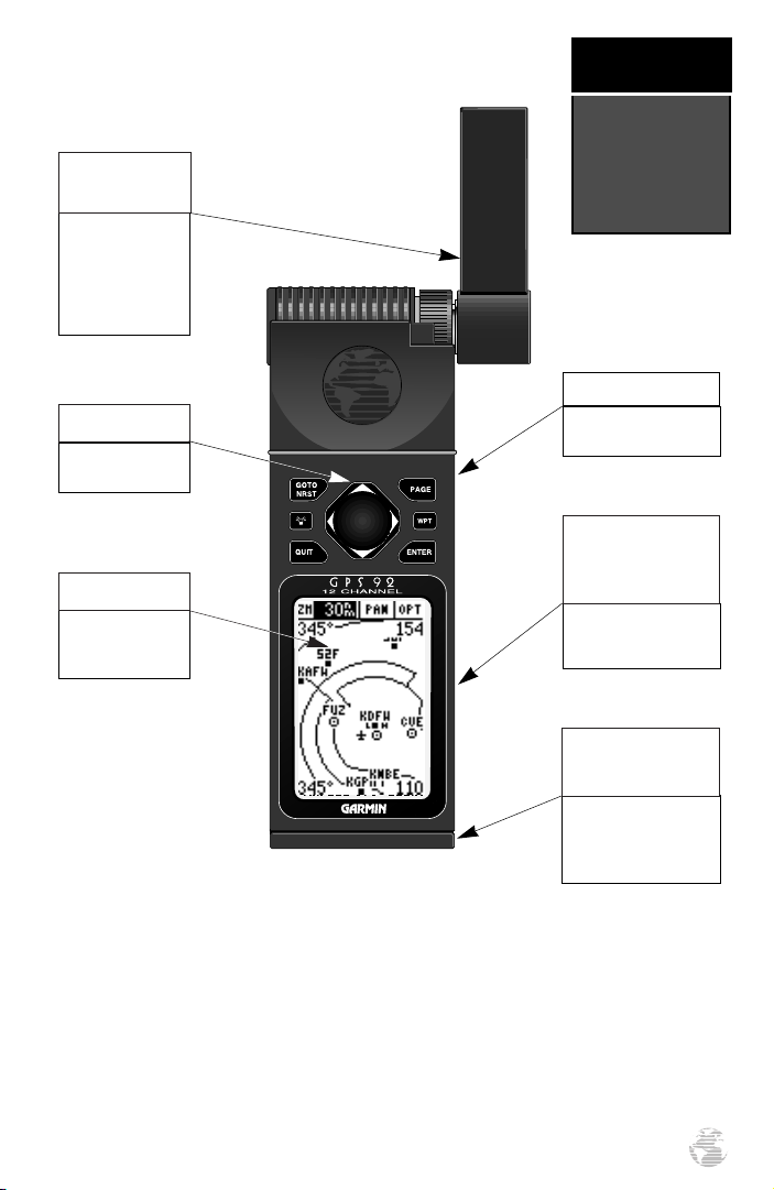
Detachable
Antenna
To remove, grab at
knurled knob base,
rotate 1/4 turn
counterclockwise
and pull away from
side of unit.
Arrow Keypad
Moves the cursor
and pans the map.
LCD Display
On-screen information is referred to
as a “page.”
GETTING
STARTED
Unit
Features
Keypad
See following page for
key descriptions.
Power/Data
Cable Connector
(back side)
Connections for power,
ground, serial data in
and serial data out.
Battery
Compartment Door
To open, turn the metal
D-ring counterclockwise
1/4 turn. Observe polarity markings on the case.
The GPS 92 features a seven-key keypad and a 100 x 64 pixel LCD display. The dis-
play can be illuminated for nighttime operation.
Information which appears on the display is referred to as a page. A page can include
graphics, text or both. The graphic map display may include icons (or symbols) for airport and navaid locations, as well as airspace boundaries.
3

GETTING
STARTED
Keypad
Usage
B
P
Q
G
M
(POWER)— Red key turns the unit on and off, and controls
three levels of screen backlighting intensity.
(PAGE)— Scrolls main pages in sequence and returns display
from a menu/option to a main page.
(QUIT)— Returns the display to a previous page, cancels an
operation or restores a data field’s previous value.
(GOTO/NRST)— Displays the GOTO waypoint window, allowing you to select the destination waypoint. Press a second time to
display the nine nearest airports, VORs, NDBs and intersections,
plus nearest FSS and center frequencies. Also provides special-use
airspace detail during an airspace incursion. When non-airport
nearest information is provided, pressing a third time will instantly return the display to the nine nearest airports.
(WAYPOINT)— Retrieves airport or navaid information from
the GPS 92’s internal database or the user waypoint from
memory. Press twice to capture your present position and save as
a waypoint.
E
U
L
D
4
(ENTER)— Activates a highlighted field to allow data entry.
Confirms menu options and data entry.
(ARROW KEYPAD)— Controls the movement of the cursor.
Used to select options and positions, and to enter data. Press on
R
a particular arrow key once to scroll through data/options slowly.
Press and hold an arrow key for faster scrolling.
Data Entry
Entering data, such as waypoint names, typically begins and
ends with the
data: UP/DOWN to change the highlighted character, RIGHT to
move to the next character.
key. Use the arrow keypad to enter the actual
E
GETTING
Battery Installation
The GPS 92 operates on 4 AA alkaline batteries (included),
which are installed at the base of the unit. These batteries provide
up to 24 hours of continuous use. Rechargeable NiCad or lithium
batteries may also be used. Battery life will vary due to a variety of
factors, including temperature and use of screen backlighting.
Lithium batteries will provide longer life in colder conditions. The
GPS 92 also features an internal 10-year lithium battery which retains your data while
changing the AA batteries or when stored with nearly depleted AA batteries.
?
NOTE: The on-screen battery level indicator is cali-
brated for alkaline batteries, and will not be accurate when
using NiCad or lithium batteries (see page 38).
To install the batteries:
1. Flip up the metal D-ring at the base of the unit, and turn the ring 1/4
turn counterclockwise. Open the compartment door to access the batteries.
2. Install the batteries and close the compartment door. When replacing the GPS 92’s batteries,
observe the polarity markings engraved in the plastic case. (The indicated polarity represents which end of the battery should be viewable when the compartment door is opened.)
3. Lock the door in the closed position by turning the D-ring 1/4 turn clockwise.
#
STARTED
Battery &
Antenna
Installation
Antenna Installation and Removal
The GPS 92’s detachable antenna can be used directly attached to the unit or detached
and used with the suction cup adapter and extension cable. Be sure to attach the antenna
at a location which provides good visibility to the sky (satellites), but does not interfere
with controls or block your view of instruments. Likewise, observe these precautions
when routing the extension cable. The antenna should be oriented as near vertical as possible—perpendicular to the ground.
5
Getting
Started
What is
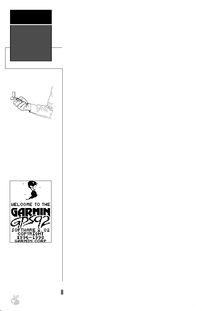
GPS?
Hold the receiver at arms
length and rotate the
antenna perpendicular to
the ground.
Welcome Page
The Global Positioning System (GPS) is a constellation of 24 satellites which circle the earth twice a day in
a very precise orbit and transmit information back to
Earth. This information includes operational status and
orbital location of each satellite in the system. The GPS
92 must continuously “see” at least three of these satellites to calculate your position and track your movement.
At times, additional satellites may be needed to determine
a position.
By using an almanac (a timetable of satellite numbers
and their orbits) stored in the receiver’s memory, the GPS
92 can determine the distance and position of any GPS
satellite and use this information to compute your position.
Your GPS receiver can only see satellites above the
horizon, so it needs to know what satellites to look for at
any given time. To use this almanac data, your GPS 92
needs to either be told its general location (be “initialized”) or given the opportunity to find itself. Once you
initialize the unit to a position, it will typically compute a
fix within a few minutes.
Initialization is only necessary under the following
conditions:
• The first time you use your receiver (new from
the factory).
• After the receiver has been moved over 500
miles (with the power off) from the last time
you used it.
• If the receiver’s memory has been cleared and
all internally stored data has been lost.
Because the GPS 92 relies on satellite signals to
provide you with navigation guidance, the receiver needs
to have an unobstructed, clear view of the sky for best
performance. In a nutshell, the GPS receiver’s view of the
sky will generally determine how fast you get a position
fix—or if you get a fix at all. GPS signals are relatively
weak and do not travel through rocks, buildings,
hangars, or heavy tree cover, so remember to keep a clear
view of the sky at all times for best performance.
6
Once the GPS 92 has calculated a position fix, you’ll
usually have anywhere from five to twelve satellites in
view. The receiver will then continuously select the best
satellites in view to update your position. If some of the
satellites get blocked, or “shaded,” the receiver can simply use an alternate satellite to maintain the position fix.
Although a GPS receiver needs four satellites to provide a
three-dimensional (3D) fix, it can maintain a two-dimensional (2D) fix with only three satellites. A three-dimensional fix means the unit knows its latitude, longitude
and altitude, while a two-dimensional fix means the unit
knows only its latitude and longitude.
Initializing Your GPS 92
To initialize the GPS 92, take the receiver outside and
find an open area where the antenna has a clear view of
the sky. You may either hold the receiver at a comfortable
height with the antenna pointing up, or mount the
receiver’s antenna on the glareshield and taxi to a clear,
unobstructed area.
To turn the GPS 92 on, press and hold the red
key.
B
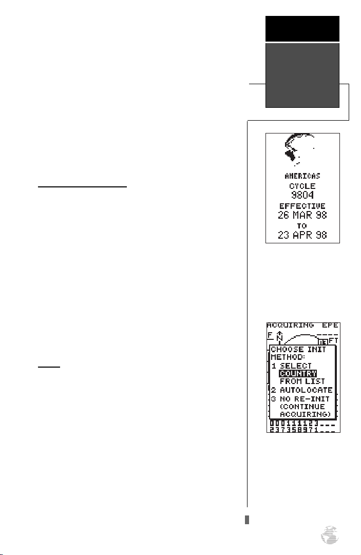
The Welcome Page will be displayed while the unit
conducts a self test. Once testing is complete, the
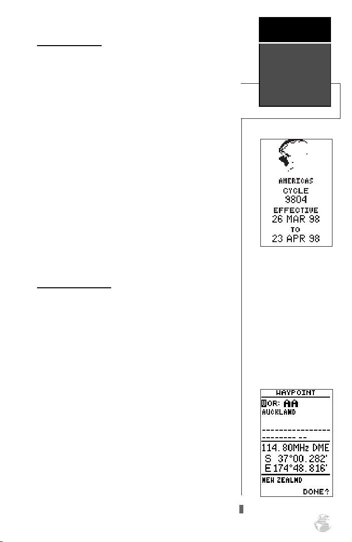
Welcome Page is replaced by the Database Page (which
shows the effective date for the Jeppesen database), then
by the Status Page.
Getting
Started
Initializing
the Receiver
The Database Page shows
the effective date for the
Jeppesen database and coverage area. Updates are
available from GARMIN or
Jeppesen on a one-time or
subscription basis.
EZinit
Your GPS 92 is shipped from the factory to display the
“EZinit” initialization prompt when first used. After a few
seconds, the EZinit prompt will appear on the Status Page
allowing you to select one of two initialization methods:
• Select Country— allows you to initialize the receiver by selecting your present position from a list of
countries in the GPS 92’s internal database. This
feature provides a position fix in 2-3 minutes.
• AutoLocate— allows the GPS 92 to initialize itself
and calculate a position fix without knowing your
present position. This feature provides a position
fix in approximately 5 minutes.
The EZinit prompt will
automatically appear if the
receiver needs to be initialized. The prompt may also
appear during normal use if
the antenna is shaded or the
unit is indoors.
7
Getting
Started
Acquiring
Satellites
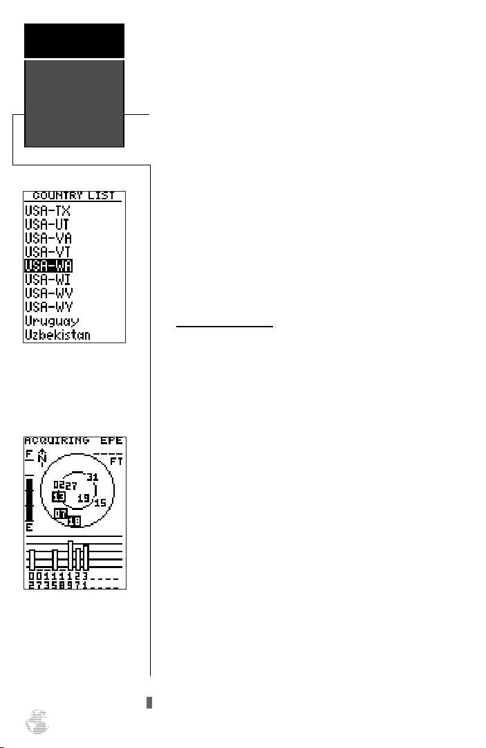
Use the arrow keypad to
highlight the country or
state of your present position from the list and press
ENTER.
Once satellites have been
found, hollow signal
strength bars will be displayed while data is being
collected. The signal
strength bars can be used to
help determine if satellites
are being shaded.
8
If the EZinit prompt has not automatically appeared
on the status page, press
If you’ve already initial-
E.
ized the GPS 92 and the EZinit prompt appears, highlight
the ‘NO RE-INIT’ selection with the arrow keypad and
press
. The EZinit prompt may appear if you’ve had
E
the unit on in normal mode while indoors, or if the
antenna is shaded while acquiring satellites.
To initialize the receiver:
1. Use the up or down arrow keys to highlight the
‘COUNTRY’ option and press
2. Use the down key to scroll through the country (and
state) listings until the country where you are presently
located appears. If the country you’re in is not listed,
select another country within 500 miles of your present
position.
3. Press
E
to finish.
E
.
Acquiring Satellites
The GPS 92 will now begin searching for the appropriate satellites for your position and should acquire a fix
within two or three minutes. Verify getting a position fix
by watching the status page transition to the position
page (provided you haven’t pressed any other keys) or by
looking for a ‘2D NAV’ or ‘3D NAV’ status at the top-left
corner of the status page.
If you have trouble initializing the receiver or getting
a position fix, check the following:
• Does the antenna have a clear view of the sky?
If there are large buildings such as hangers, metal sur-
faces, or other obstructions, the unit may not be
receiving enough satellite signals to calculate a fix.
• Is the right country/state selected from the EZinit
list?
Check for the correct approximate lat/lon on the
position page or reselect the appropriate country
from the list to restart the initialization.
• Have you moved more than 500 miles from the
last calculated position with the receiver off?
Reinitialize the receiver, selecting the country/state of
your new location from the EZinit list.
To turn the GPS 92 off, press and hold B.
GPS 92 Takeoff Tour
The takeoff tour is designed to quickly guide you
through basic features and functions of the GPS 92 using
a simulated trip.
Once you’ve completed the tour and become familiar
with the main pages and features of the unit, refer to the
reference section for complete instructions on installation
and performing specific tasks and functions.
The takeoff tour assumes you have initialized the unit
and have not changed any of the default settings. If you
have changed any settings, the descriptions and pictures
used may not match your configuration. You’re now
ready to power up and take off.
To turn the GPS 92 on, press and hold the red
key.
B
After the unit performs a self-test, the database information page will appear, listing the effective date of the
aviation database. After a few seconds, the database information page will be replaced with the satellite status
page. The status page provides a visual reference of satellite acquisition and status, with signal strength bars and a
satellite sky view in the center of the screen.
Takeoff
Tour
Power On
Important!
T
he takeoff tour assumes
you are using an Americas
database. If you are using
an Atlantic International
database, try simulating a
flight from EGLC to EGSR.
For a Pacific International
database, try flying PHDH
to PHNG. Or try a flight
using two airports of your
own choosing.
Scrolling Through the Main GPS Pages
The GPS 92 features five main GPS pages in a continuous loop: satellite status, position, map, navigation, and
main menu. Try scrolling through the pages by pressing
You can also scroll in the opposite direction (or
.
P
return to a previous page) by pressing
Q
.
Use the status page to
instantly verify satellite
coverage, reception and
current signal strength.
Position accuracy is also
indicated in the upper righthand corner of the page.
9
Takeoff
Tour
Page Sequence
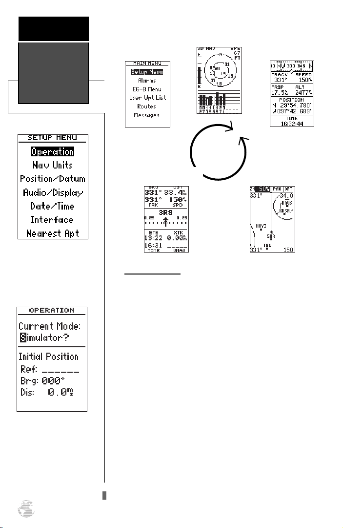
Start from the main menu
page’s ‘Setup Menu’ option
to select simulator mode.
Status Page
Menu Page
Position Page
P
Q
Navigation Page
Simulator Mode
To continue the Takeoff Tour, you’ll need to put the
GPS 92 in simulator mode:
Map Page
The ‘Operation’ mode page
allows you to enable the
built-in simulator and
select a starting position
for a simulated trip.
10
1. Press Prepeatedly until the main menu page
appears.
2. Use the up or down arrow keys to move the field highlight to the ‘Setup Menu’ option and press
3. Highlight the ‘Operation’ field and press E.
4. Highlight the ‘Current Mode’ field and press E.
5. Use the arrow keys to toggle through the options until
you reach ‘Simulator’ and press
E
.
E
.
The field highlight will move to the initial position
field, where you can enter the starting position of our
simulated flight, Lockhart Municipal Airport (50R, the
ICAO identifier), in Lockhart, Texas. Let’s see how the
data entry process works on the GPS 92:
1. Press Eto begin data entry. Notice that the highlighted area changes from the entire line to a single
character.
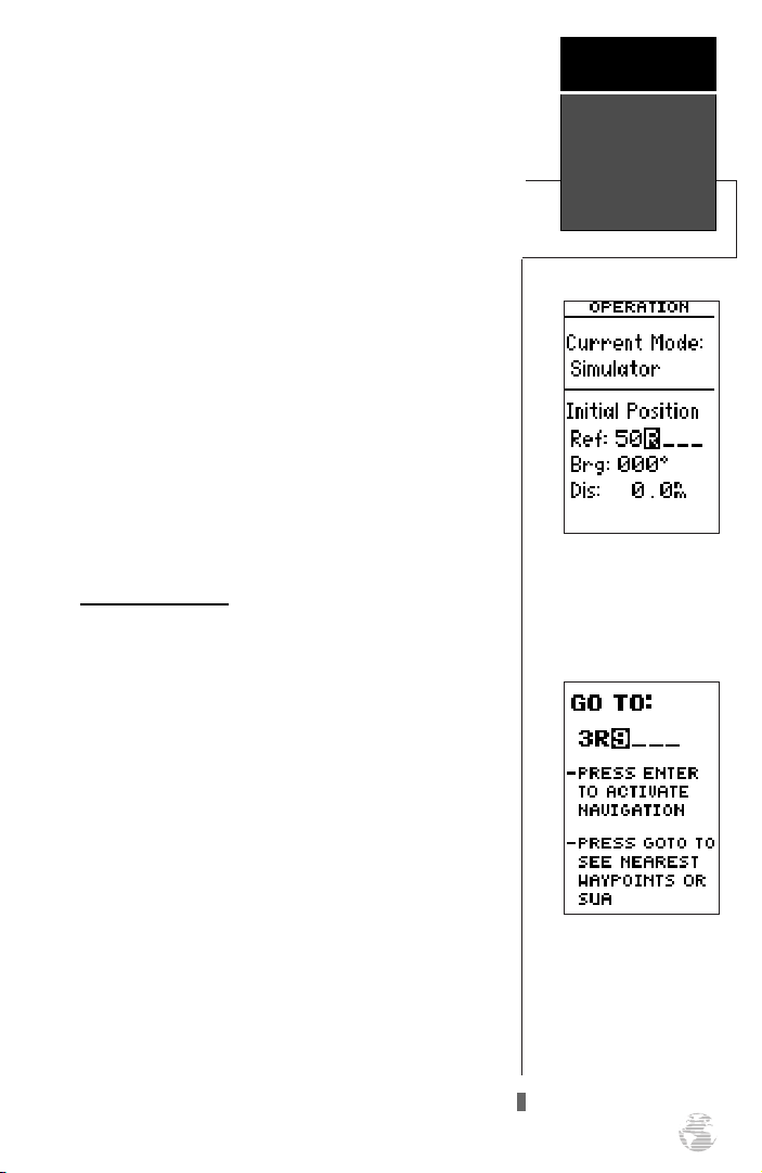
2. Use the up or down arrow keys to select the first character (‘5’). If you press and hold either arrow key, it will
scroll through the characters more quickly.
?
NOTE: When entering waypoint identifiers, the GPS
92 will scroll through the available database, displaying
any waypoints with the same letters you have entered to
that point.
3. Press the right arrow key to highlight the next character
field. (If you make a mistake, press the left arrow key to
back up to the previous character.)
4. Repeat steps 2 and 3 until ‘50R’ appears on the reference waypoint field.
Since we’ll be taking off from the airport, keep the
bearing and distance values at zero to keep your position
located at the airport.
To return to the main menu page:
#
Takeoff
Tour
Activating a
GOTO
1. Press Qtwice.
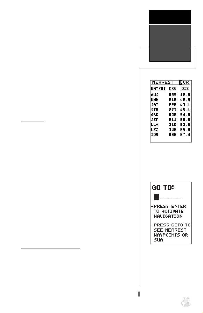
Activating a GOTO
Once you have entered the starting position of your
flight, the next step is to select your GOTO destination,
Lakeway Airport (3R9), in Austin, Texas.
1. Press G.
2. The GOTO page will appear with the identifier field ready
to accept changes.
3. Use the arrow keys to enter the identifier of the destination waypoint (‘3R9’). (Remember, up/down arrow keys to
change a character, right arrow key to move to the next
character field.)
4. Press
simulated navigation.
to confirm your destination and activate the
E
Entering the initial starting
position of 50R.
Entering the destination
waypoint, 3R9.
11
Takeoff
Tour
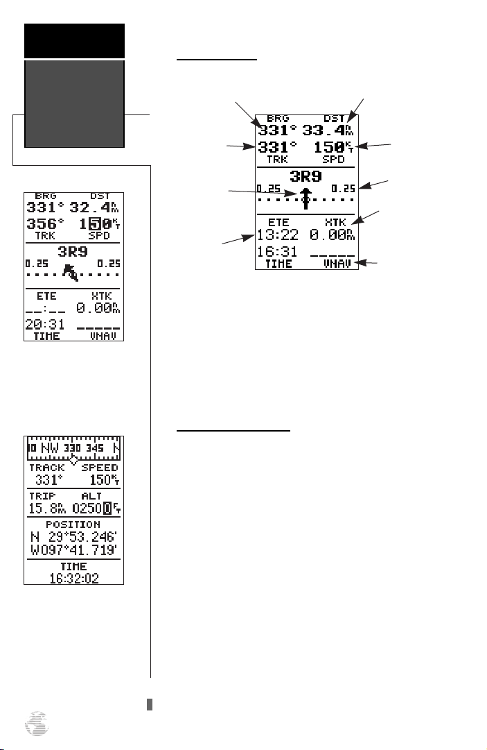
Navigation Page
Navigation
Page
In simulator mode, speed
may be entered from the
navigation page speed field.
NOTE: Never use simulator
mode for actual navigation.
Bearing to
Waypoint
Track Over
Ground
Relative Bearing
Pointer
Estimated
Time Enroute
Distance to
Waypoint
Speed Over
Ground
CDI Scale
Crosstrack
Error
VNAV Altitude
Field
Once a GOTO is activated, the navigation page will
display the bearing and distance to the destination, along
with your present speed and ground track. The GOTO
destination is listed above the course deviation indicator
(CDI), with your estimated time enroute (ETE), cross
track error (XTK) and time displayed at the bottom of the
page. A relative bearing pointer, located at the center of
the CDI scale, points to the direction of your destination.
Simulated Speed Entry
Now you’ll need to enter a speed for the aircraft:
1. Highlight the ‘SPD’ (speed) field.
2. Press
3. Use the arrow keys to enter a simulated speed of 150
knots.
to begin data entry.
E
Entering an altitude of
2,500 feet on the position
page.
12
4. Press
to confirm the selected speed.
E
Once a speed has been entered, the navigation page
will continuously update as we make our way to the destination airport. We now need to enter the cruising altitude
of our flight, which can be entered from the position page:
1. PressPuntil the position page appears.
2. Move the field highlight to the ‘ALT’ (altitude) field and
press
3.
Enter an altitude of 2,500 feet using the arrow keys (remember to start with a zero) and press
E
.
to confirm.
E
Position Page
The GPS 92’s position page displays your present latitude, longitude and altitude, along with your current
track and speed over the ground. The top of the page also
features a graphic heading indicator, which displays your
ground track as you’re moving. The time of day, displayed
in UTC (zulu) or local time, is indicated near the bottom
of the page.
Most of your in-flight navigation with the GPS 92 will
center around the navigation and moving map pages.
Now that we’re on our way, let’s move on to the map page
by pressing
P
.
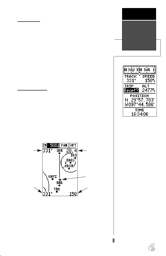
Moving Map Page
The GPS 92’s moving map page provides extensive
capabilities and information on your present position,
nearby facilities and waypoints, and your active route.
Let’s zoom in for a closer look at our progress:
Takeoff
Tour
Position &
Map Pages
1. Highlight the ‘ZM’ (zoom) field—it may be already be
highlighted—and press
2.
Press the down arrow key (as often as needed) to change
the scale to the 30nm setting, and press
Bearing to
Waypoint
Track Over
Ground
E
.
to confirm.
E
Distance to
Waypoint
Plane Icon
Speed Over
Ground
At the 30nm scale, you’ll be able to see your plane,
nearby airports and airspace boundaries. The line up the
center of the page represents the track-up route from
your starting point (50R) to the destination airport (3R9),
with your present position indicated by the plane icon.
Notice that your plane remains centered on the map,
while nearby waypoints pass by, based upon your present
speed and track.
The position page features a
resettable trip odometer to
keep track of your distance
traveled. The trip odometer
is resettable, allowing you
to keep track of distance
traveled from a starting
point which you specify.
Other options are also
available to display average
speed (AVSPD), maximum
speed (MXSPD), trip time
(TTIME) and elapsed time
(ELPSD).
13
Takeoff
Tour
Map Page
Use the ARROW KEYPAD
to select on-screen waypoints by moving the cursor
onto the waypoint name.
Whenever a waypoint identifier is highlighted, pressing
enter will allow you to
review information pages.
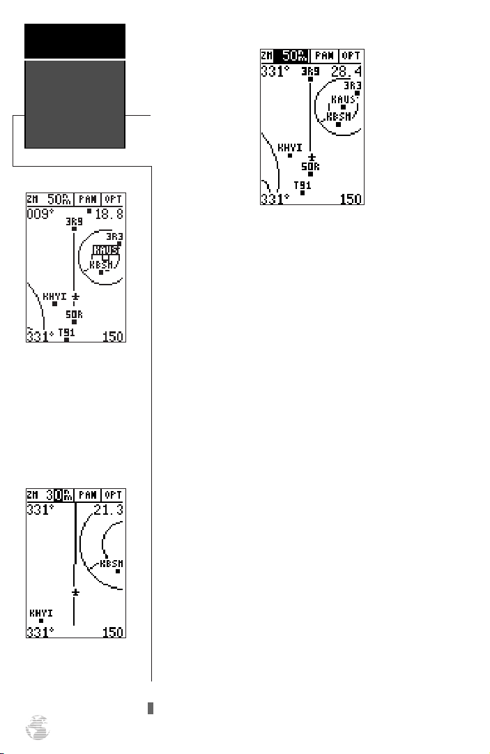
The moving map page can be broken down into three
parts: the zoom, pan and option fields (located at the
top of the page), the moving map field, and the bear-
ing, distance, track and speed fields (located in the
corners of the map). The zoom and pan fields provide
access to the map scale and scrolling cursor functions.
The option field allows you to determine which items are
displayed on the screen, while the moving map field lets
you highlight on-screen airports and waypoints for
immediate review. The bearing, distance, track and speed
fields are display fields only, and do not provide access to
other functions.
The default placement of the cursor highlight is on
the zoom field. To move the cursor to the pan field or
through the on-screen waypoints, simply use the arrow
keypad to move in the desired direction, and press
E
to activate the function or review the selected waypoint.
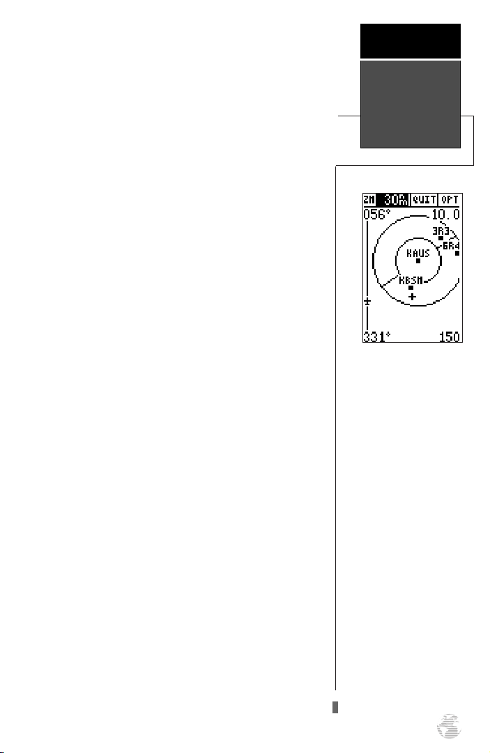
Try selecting ‘KAUS’, just right of our current route, to
practice:
Zooming in to lower scales
will show fewer waypoints
and make the screen less
crowded.
14
1. With the field cursor on the zoom field, press the down
and/or up arrow keys until the ‘KAUS’ identifier field is
highlighted.
2. Press
‘KAUS’.
to review the waypoint location page for
E
The waypoint location page for ‘KAUS’ will appear,
providing you with the facility’s name and location
(city/state/region), with the elevation, latitude and longitude of the field, and fuel available (AV, Jet or Mogas). In
addition to the location page, each airport in the GPS 92’s
database features separate communication and runway
pages, which are accessible from the prompts located
near the bottom of the location page.
To view the airport communication page for ‘KAUS’:
Takeoff
Tour
1. Use the left arrow key to highlight ‘COMM?’ and press
.
E
All of the available frequencies for the selected airport
will be displayed, with the designation shown at the left
of each frequency. If there are more than seven frequencies for a selected airport, use the up and/or down arrow
keys to view additional frequencies.
To view the runway information page:
1. Press E(repeatedly, if necessary) until the runway
information page is selected.
The runway information page features a diagram of
the available runways, along with runway length, surface
type and lighting for each runway.
To return to the moving map page:
1. Move the field highlight to the ‘DONE?’ prompt and press
.
E
Once you’re back on the moving map page, you’ll
notice that our plane is getting close to the special use airspace (SUA) surrounding ‘KAUS’.
Whenever you are within 2 nm of an SUA, projected
to enter an SUA or inside an SUA, the GPS 92 will notify
you with a message and supply detailed information on
each SUA you are being alerted to. By looking closely at
the map display, you’ll notice that we will come very close
to the KAUS SUA, but not actually enter it. Once our
flight takes us within 2 nm of the SUA, we’ll be alerted
with a ‘Near SUA < 2nm’ message (you may have to wait
a minute or two to get the message, depending on how
fast you’ve made your way through the tour).
To view the SUA message:
Airport Pages
& SUAs
The GPS 92’s sectorized
airspace boundaries let you
watch your proximity to
each boundary on the
moving map.
1. Press P.
To return to the map page, press Pagain.
15
Takeoff
Tour
Nearest
Waypoints Page
The nearest SUA page provides information about
special-use airspace alerts.
Additional information, including the name, class,
controlling agency and altitudes, is available from the
G
key. To view additional SUA information:
1. Press Gtwice. The nearest SUA alarm page will
appear, which can display up to nine SUA alerts at once.
Each listing will display the type of alert and time to
intrusion, if applicable.
2. To view specific information on any listed SUA, highlight
the desired SUA name and press
E
.
The SUA page will appear, providing additional
information on floor and ceiling altitudes for the
selected SUA.
3. To return to the nearest SUA list, press E.
4. To return to the map page from the SUA list, press Q.
Alert messages for the various classes of SUAs may be
turned off to avoid nuisance alerts, and SUA boundaries
may be removed from the map to avoid excess clutter at
higher map scales. For complete information and definitions on SUAs, see page 59.
Nearest Waypoints Page
The nearest waypoints page displays the nine nearest
airports, VORs, NDBs, INTs, and user waypoints to your
present position, and is extremely useful for locating the
nearest facility during an in-flight emergency. In addition,
nearest flight services stations (FSS), Air Route Traffic
Control Centers (ARTCC), and special use airspace alarms
can also be viewed.
To view the nearest waypoints of a particular category, you need to select the desired category from the category field at the top of the nearest page. Let’s practice by
viewing the nearest airports to our present position:
The bearing and distance to
the nine nearest airports
may be quickly accessed on
the nearest airport page for
use in an emergency or for
general information.
16
1. Press Gtwice to display the nearest page. Most likely,
it still shows nearest SUA alarm information.
2. Press
the desired nearest category. This feature is always
available to immediately retrieve airport information.
3. To select a different category, highlight ‘APT’ and press
E
desired category and press
a third time to immediately select airports as
G
. Use the up and down arrow keys to select the
to confirm selection.
E
Once you’ve selected and confirmed a category, the
GPS 92 will display the nine nearest facilities and provide
the distance and bearing to each waypoint in the list. To
scroll and review the nearest waypoints list:
1. Highlight the desired waypoint, using the arrow keypad.
2. Press Eto review the waypoint page(s).
3. Press Eagain to return to the nearest list. The field
highlight will sequence to the next waypoint on the list.
4. To GOTO a nearby airport, highlight the desired waypoint
on the list, press
5. Press
Q
the previously viewed page.
and E.
G
to exit the nearest function and return to
Auto Zoom
You will notice that as we make our way toward the
destination airport, the map scale will automatically
zoom in to provide a closer look at the airport. What
you’re actually seeing is the GPS 92’s AutoZoom feature.
Whenever you select a GOTO destination, the map page
will default to the 50 nm setting and gradually zoom
down the map scale to the 1.2 nm setting.
The map scale will zoom to the next lowest setting
(i.e., from 50nm to 30nm) whenever the map can fit both
your present position and your destination on the screen.
If you manually zoom in the map scale before this
point, the AutoZoom feature will resume once it catches
up to the map scale you have selected (down to 1.2 nm).
If the map is manually zoomed out beyond the
AutoZoom scale, the AutoZoom will be canceled, and the
GPS 92 will assume you want to stay at the scale you have
manually selected.
Takeoff
Tour
AutoZoom &
Cancel GOTO
Information on the nine
nearest VORs is available
by selecting the ‘VOR’
category.
Canceling GOTO Navigation
By now, our plane should be approaching ‘3R9’, the
destination airport. The map will continue to zoom down
to the 1.2 nm scale. To finish the tour and complete our
approach, let’s move back to the navigation page:
1. PressPto display the navigation page.
Cancel GOTO
Use the LEFT ARROW key
to clear the GOTO field
and press ENTER to
cancel GOTO navigation.
17
Takeoff
Tour
Power Off
Once we fly past the airport, notice that the GPS 92
continues to provide navigation to ‘3R9’, with the relative
bearing pointer and ETE fields indicating we have passed
our destination. The GOTO destination may be canceled
by activating another GOTO or canceling the current
GOTO.
To cancel the current GOTO:
1. Press G.
2. Press the left arrow key once to clear the destination
field (pressing the left arrow key clears a selected field
when the cursor is in the left most character position).
3. Press
Power Off
Congratulations! You have now mastered the basic
features of the GPS 92 and you’re ready to take off with a
powerful tool that can help make your flights smoother
and more efficient.
E
to confirm.
18
To turn the GPS 92 off, press and hold the red
key. (The unit will count down for two seconds as it
shuts off.)
Thank you for choosing the GARMIN GPS 92. We
hope it will be a valuable navigation tool for you,
wherever your course may take you.
Be sure to carefully review the sections on installation and the internal database so you can get the most
out of your new GPS 92. The takeoff tour has only
explored a small part of what this GPS receiver can do
for you. The reference section will describe in detail all
of the GPS 92’s functions and features.
B
Internal Database
The GPS 92 uses an internal Jeppesen
®
database to
provide position and facility information for thousands of
airports, VORs, NDBs and intersections. Each facility in
the database is stored as a waypoint, with its own latitude/longitude, identifier (up to six letters and/or numbers) and other pertinent information. There are three
database coverage areas available for the GPS 92. They
are referred to as “Americas”, “Atlantic International”, and
the “Pacific International” databases.
The International Civil Aviation Organization (ICAO)
and Aeronautical Radio, Inc. (ARINC) break the world
into ten geographic regions. The GPS 92 Americas database contains aeronautical information for the group of
ICAO regions consisting of North, Central, and South
America. The ‘Atlantic International’ database provides
information for the ICAO regions of Europe, Africa,
Eastern Europe, and the Middle East. The Pacific
International database gives information for the ICAO
regions of Eastern Europe, Middle East, Pacific, and
South Pacific.
Waypoint Categories
Five categories of waypoint information are available
through the
key. Each category provides different
M
types of detailed information for a selected facility:
• Airports— Identifier, city/state, country, facility
name, position (lat/lon), elevation, fuel services,
runways, and communications frequencies.
• VORs— Identifier, city/state, country, facility
name, position (lat/lon), frequency and co-located
DME or TACAN availability.
• NDBs— Identifier, city/state, country, facility
name, position (lat/lon) and frequency.
• Intersections— Identifier, region/country, posi-
tion (lat/lon) and range/bearing to nearest VOR.
• User— Identifier (name), position (lat/lon), user
comments and reference waypoint.
To view the waypoint information for a desired waypoint, select the waypoint category from the category
field, located at the top left of the waypoint page, next to
the identifier field.
Reference
Waypoint
Categories
The GPS 92’s internal
Jeppesen database is available with an Americas,
Atlantic International, or
Pacific International database. The database cycle
is displayed on the
database information page.
Information on updating
the database is included
with your GPS 92 package.
19
Reference
To choose a waypoint category:
Entering
Waypoint
Identifiers
Entering a waypoint
identifier.
1. Press Mto display the waypoint page.
2. Highlight the category field.
3. Press Eto begin selection of the waypoint category.
4. Use the arrow keys and select the desired category.
5. Press Eto confirm the category selection.
Entering Identifiers
After a waypoint category is selected, information for
a waypoint can be viewed by entering the identifier or
name of the desired waypoint. Airports, VORs, and
NDBs may be entered by either the identifier, facility
name, or the location (city). Intersections and user
waypoints must be entered by the identifier.
To enter a waypoint identifier:
1. Highlight the identifier field and press E.
2. Enter the desired identifier using the arrow keypad, and
press
NOTE: As the identifier is entered, the GPS 92 will
scroll through the available database, displaying any waypoints with the same identifier letters you have entered to
that point. Once the desired waypoint is displayed, press
.
E
After you’ve selected a waypoint category, waypoint
information can also be retrieved by entering the facility
name of the airport, the name of the VOR or NDB, or
their city location (intersections and user waypoints
cannot be retrieved by facility or city name).
To select a waypoint by facility or city name:
E
.
?
#
Entering a waypoint by
facility name.
20
1. Select the desired waypoint category (APT, VOR or NDB)
as described at the top of this page.
2.
Highlight the facility name or city name field. Press E.
3. Enter the name of the facility or city and press E.
Once a waypoint category and identifier have been
selected, the GPS 92 will provide extensive information
through various waypoint review pages.
 Loading...