

Page 1
BBWX3 SIRIUSXM SATELLITE WEATHER
REFERENCE MANUAL
The purpose of this manual is to provide operating procedures for Navnet NN3D’s
SiriusXM Satellite Weather capability. An optional SiriusXM Weather Receiver BBWX3
and SiriusXM subscription are required. This manual is provided in addition to the
Navnet NN3D operator’s manual, which fully covers operating procedures for the
NavNet NN3D system. SiriusXM weather coverage is currently only available in U.S.
and Canada.
Disclaimer – The weather information is subject to service interruptions and may contain errors or
inaccuracies and consequently should not be relied upon exclusively. The service is provided as is.
You are urged to check alternate weather information sources prior to making safety related
decisions. You acknowledge and agree that you shall be solely responsible for use of the
information and all decisions taken with respect thereto. By using this service, you release
and waive any claims against SiriusXM Satellite Radio Inc., WSI, Navcast Incorporated and Furuno
with regard to this service. If you do not have the subscription agreement, you will nd a copy at:
www.sirius.com/marineweather/marineweather_terms_and_conditions.pdf
Or call 1-800-869-5480 to have a copy sent to you.
FURUNO ELECTRIC COMPANY
www.furuno.co.jp
Page 2

Weather
1.1 Weather Display Overview
When connected to the SiriusXM Weather Receiver BBWX3, this MFD will display current
and forecasted weather information for your area. Real time updating ensures that you
have up-to-the-minute weather information for your area, as well as any other area in
the U.S.
Information provided by the SiriusXM Marine Weather service is advisory nature only.
You, the customer, agree to release FURUNO ELECTRIC CO., LTD., Sirius Satellite
Radio Inc., Navcast Inc. and WSI Corporation from any and all claims arising from the
use of this service, and you acknowledge that you have read the terms of your subscription agreement and agree to all the terms therein. If you do not have the subscription agreement, you will find a copy at: www.sirius.com/marineweatheragreement or
call 1-800-869-5480 to have a copy sent to you.
Before using the weather application:
• Obtain an optional SiriusXM Weather Receiver BBWX3.
• Obtain a SiriusXM weather service subscription. Contact Sirius Satellite Radio INC., for
further details.
• After connecting and powering up both the BBWX3 and the associated MFD displays, it may take up to 30 minutes for your MFD to receive/accumulate WX data
from the BBWX3.
• If, during the installation of the equipment, the Installation Wizard fails to acknowledge the existence of the BBWX3, Sirius-related menus will not appear. Confirm
that the equipment acknowledges the SiriusXM receiver.
1
Page 3
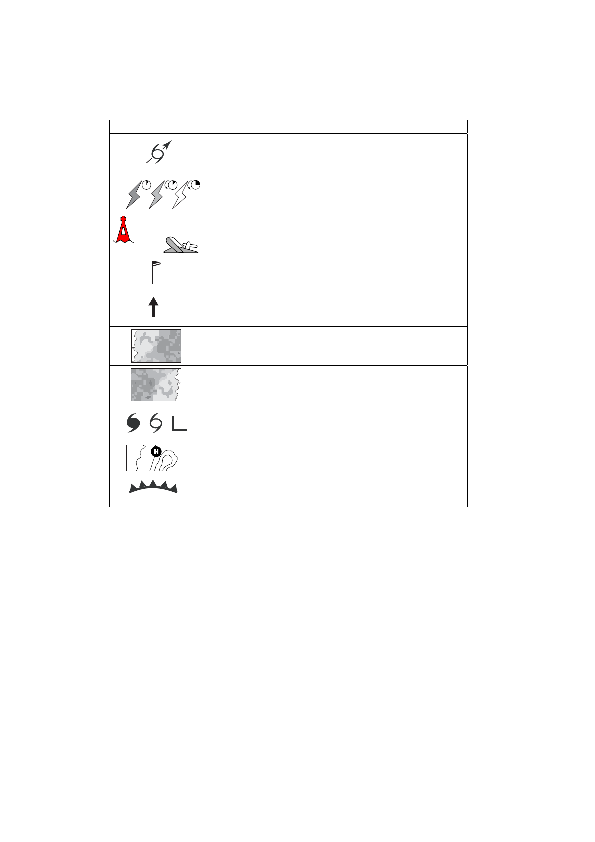
1.2 Weather Icons
The table below shows the weather icons that appear the SiriusXM Satellite Weather
display. These icons can be shown or hidden from the Weather menu.
Icon Meaning
Purple Storm cast
Dark yellow (recorded in last 0-5 min.)
Medium yellow (recorded in last 5-10 min.)
Light yellow (recorded in last 10-15 min.)
Buoy or
CMAN sta.
Buoy: Red
CMAN station: Grey
Airplane: White
Pink & Blue
Dark blue
Red-blue
Green (Rain)
Blues (Snow)
Pinks (Mixture)
Grey (Historical)
Red (Current)
Orange (Forecast)
Color
Lightning
Surface
observation
stations
Wind
Waves
Sea surface
temperature
NOWRAD
(USA RADAR)
Storm tracks
etc.
For details, see your MFD Op Manual
Surface
pressure
2
Page 4
1.3 Weather Menu
The Weather menu lets you adjust the following weather-related items:
• Overlay transparency
• Color scale
• Weather radar (US or Canada)
• Standard weather data
• Advanced weather data
1.3.1 Displaying the Weather Menu
1. Press the MENU key to open the menu.
2. Use the RotoKey to open the Weather-Sirius menu.
3. Use the RotoKey to select the weather item that you want to show or hide.
4. Push the RotoKey to alternately turn the item on and off.
5. Press the MENU key to close the menu.
3
Page 5
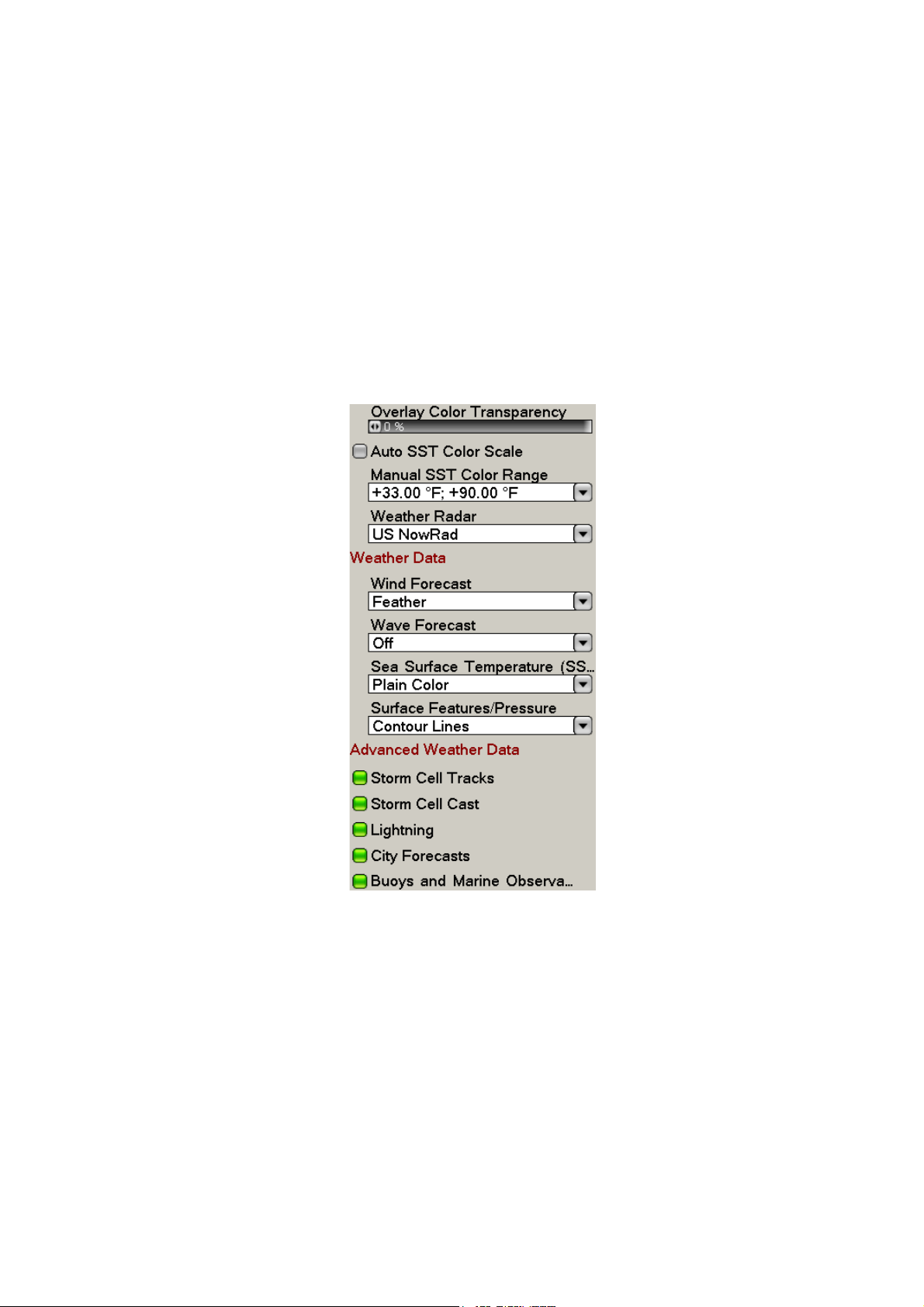
1.3.2 Weather Menu Description
Overlay Color Transparency
Adjust the transparency level of the weather overlay. Select this item with the RotoKey
and push the RotoKey. Rotate the RotoKey to set and then push it to confirm setting.
The higher the value the greater the transparency of the overlay.
Auto SST Color Scale
Enable/disable automatic adjustment of sea surface temperature color scale according to sea surface temperature.
Manual SST Color Range
Set the SST color range when Auto SST Color Scale is disabled. The setting range is
+00.00 to 99.99 (degrees Fahrenheit).
Weather Radar
The BBWX3 can display the USA NOWRAD weather radar system. USA NOWRAD
shows the type and level of precipitation. The "Level" number shown below denotes a
figure of reflectivity from a weather radar. The large
precipitat
ion. CANRAD (Canada) is now included in available USA NOWRAD data.
r the level number, the stronger the
Precipitation indication on NOWRAD.
Weather radar color Precipitation type Level
Light green Rain 15-19 dBz (Mist)
Medium green Rain 20-29 dBz (Light)
Dark green Rain 30-39 dBz (Moderate)
Yellow Rain 40-44 dBz (Mod-Heavy)
Orange Rain 45-49 dBz (Heavy)
Light red Rain 50-54 dBz (Very Heavy)
Dark red Rain over 55 dBz (Heavy/Hail)
Light blue Snow 5-19 dBz
Dark blue Snow over 20 dBz
Light pink Mixed 5-19 dBz
Dark pink Mixed over 20 dBz
4
Page 6
Weather Data
n
t
Wind Forecast
Select how to show the wind forecast. There are two types of wind icon styles: Vane
feathers and Plain colors. Vane feathers also show you wind speed and direction, but
give you more details about the wind speed per the description shown below.
3-7 8-12
13-17
18-22 23-27
28-32 33-37
Wind Force 10.0 kt
Wind Direction 306.5
M
Wave Height +11.0 ft
Wave Direction 141.5
M
Wave Period 0m00s
38-42 43-47 48-52
53-57 58-62 63-67 68-72
Place cursor on a wind icon or
anywhere on a body of water
and hit the left-click button to
show wind and wave informatio
for that area.
73-77
78-82 83-87 88-92 93-97 98-102
(kt)
Waves Forecast
The Waves layer depicts wave height, with a dark blue arrow whose length increases
with wave height. To find wave information place the cursor on a wave symbol and hit
hit the left-click button.
Wind Force 30.0 kt
Wind Direction 186.5
Wave Height +12.50 f
Wave Direction 156.5 M
Wave Period 0m00s
M
5
Page 7

Sea Surface Temperature
This data layer shows the temperature of the sea surface in shades of red and blue,
in order of descending temperature.
Surface Features/Pressure
Enable this feature to get surface pressure with meteorological symbols. The cursor
may be placed on a surface pressure icon to show the name of the surface pressure.
Seasurfacetemp icon Color Meaning
Blue High pressure
L
1010
1012
Red Low pressure
Red Warm front (Red)
Blue Cold front (Blue)
Purple Occluded front (Purple)
Red-blue Stationary front (Red-Blue)
Brown Trough
Red Squall line
Brown Dryline
Grey Isobars
6
Page 8

Advanced Weather Data
Storm Tracks
The storm track icons show significant storms in your area. These include tropical disturbances, depressions, storms and cyclones, hurricanes, typhoons and super typhoons. These symbols are displayed in three different colors: Grey, historical; Redcurrent, and Orange, forecast.
Storm tracks
Icons
Hurricane (Category 1-5)
Tropical storm
Tropical disturbance, Tropical depression
Meaning
To find simple storm tracks information, place the cursor on the icon. For more detailed information, press the left-click button.
Simple storm tracks information
Detailed storm tracks infomration
7
Page 9

Storm Cell Cast
You can find the direction and speed of a storm by placing by placing the cursor on
the icon. For more detailed information, press the left-click button.
Simple storm cell cast information
Detailed storm cell cast information
8
Page 10

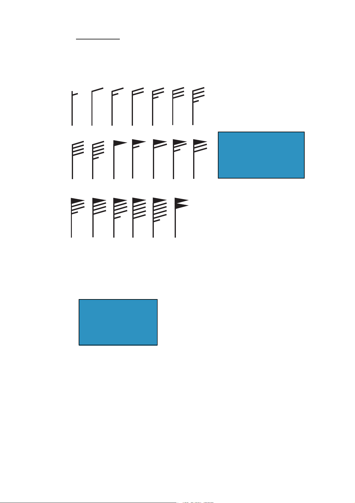
Lightning
g
The lightning icons show where lightning has struck, within the last 5, 10 and 15 minutes. The icon's fill color indicates how recent the lightning strike was, as shown in the
table below. The number of lightning bolt markers indicates the number of times lightning has struck.
Lightning
icons
.Description of lightning icons
Lightning
icon
Color Period
Orange Last 0-5 min.
Medium yellow Last 5-10 min.
Light yellow Last 10-15 min.
To find simple lighting information, place the cursor on it. For more detailed information, push the left-click button.
Simple lightning information
Detailed li
htning information
9
Page 11

Buoys
You can check the historical or current weather information at buoys.
For simple information, place the cursor on the buoy icon ( ), etc. For more detailed information, push the left-click button.
Simple buoy information
Detailed buoy data
Scroll for
more data
10
Page 12

1.4 Weather Reports
Marine zone forecasts, marine warnings, tropical information and weather alerts are
sent to your unit. You can view them on the Weather menu, by opening respective sub
menu.
SiriusXM sends warning messages to alert you to bad weather. You can view these messages by opening the Weather-Alert Box menu.
1.4.1 Marine Zone Forecast
These forecasts cover the following areas.
• US coastal weather forecasts
• US offshore forecasts
• High seas forecasts
• Great Lakes forecasts
• Near Shore forecasts
• Canadian coastal weather forecast.
11
Marine zone forecast
Page 13

1.4.2 Marine warning
Display the marine warnings (US coastal or near shore).
NO REPORT AVAILABLE FOR THIS MARINE ZONE.
1.4.3 Tropical Statement
Below is an example of a tropical weather statement.
12
Page 14

1.4.4 Marine WatchBox
The message "Weather Alarm, Press Menu Button" appears on the status bar when
a tornado or thunderstorm warning is received. To view the details of the warning,
press the MENU key to open the Alert Box in the Weather menu. The message is automatically opened in the Alert Box. A typical warning message is shown below.
You can show or hide the WatchBox warning message with SiriusXM Marine WatchBox
in the Alarm-General menu.
13
Page 15

Glossary of weather terms
Absolute Humidity- The density of water vapor. It is the mass of the water vapor
divided by the volume that it occupies.
Advisory- Advisories are issued for weather situations that cause significant
inconveniences but do not meet warning criteria and, if caution is not exercised, could
lead to life-threatening situations. Advisories are issued for significant events that are
occurring, are imminent, or have a very high probability of occurrence.
Air Pressure- (atmospheric pressure) air pressure is the force exerted on a surface by
the weight of the air above it. The internationally recognized unit for measuring this
pressure is the kilopascal.
Atmospheric Pressure- (also called air pressure or barometric pressure) The pressure
asserted by the mass of the column of air directly above any specific point.
Barometric pressure- The actual pressure value indicated by a pressure sensor.
Cold Front- A narrow transition zone separating advancing colder air from retreating
warmer air. The air behind a cold front is cooler and typically drier than the air it is
replacing.
Coordinated Universal Time (UTC) - The time in the zero degree meridian time zone.
Cyclone- An area of low pressure around which winds blow counterclockwise in the
Northern Hemisphere. Also the term used for a hurricane in the Indian Ocean and in the
Western Pacific Ocean.
Depression- a region of low atmospheric pressure that is usually accompanied by low
clouds and precipitati o n.
Doppler Radar- A type of weather radar that determines w hether at mospheric motion is
toward or away from the radar. It determines the intensity of rainfall and uses the
Doppler Effect to measure the velocity of droplets in the atmosphere.
Extended Outlook- a basic forecast of general weather condi tions three to five days in
the future.
Forecast- A forecast provides a description of the most significant weather conditions
expected during the current and following days. The exact content depends upon the
intended user, such as the Publi c or Mar ine f or ecas t audiences.
Front- The boundary or transition zone between two different air masses. The basic
frontal types are cold fronts, warm front s and oc cl ude d fro nt s.
14
Page 16

Fujita Scale- System developed by Dr. Theodore Fujita to classify tornadoes based on
wind damage. Scale is from F0 for weakest to F5 for strongest tornadoes.
Gale- Sustained wind speeds from 34 to 47 knots (39 to 54 mph).
High- An area of high pressure, usually accompanied by anticyclonic and outward wind
flow. Also known as an anticyclone.
Humidity- The amount of water vapor in the atmosphere.
Hurricane- A severe tropical cyclone with sustained winds over 74 mph (64
knots). Normally applied to such storms in the Atlantic Basin and the Pacific Ocean
east of the International Date Line.
Isobar- A line of equal barometric pressure on a weather map.
Knot- A measure of speed. It is one nautical mile per hour (1.15 mph). A nautical mile
is one minute of one degree of latitude.
Lightning- Any form of visible electrical discharges produced by thunderstorms.
Low- An area of low pressure, usually accompanied by cyclonic and inward wind flow.
Also known as a cyclone.
Millibar- A metric unit of atmospheric pressure. 1 mb = 100 Pa (Pascal). Normal
surface pressure is approximately 1013 millibars.
NEXRAD: NEXt Generation RADar. A NWS network of about 140 Doppler radars
operating nationwide.
NOAA- National Oceanic and Atmospheric Administration. A branch of the U.S.
Department of Commerce, NOAA is the parent organization of the National Weather
Service.
Occluded Front- A complex frontal system that occurs when a cold front overtakes a
warm front. Also known as an occlusion.
Pressure- The force exerted by the interaction of the atmosphere and gravity. Also
known as atmospheric pressure.
Relative Humidity- The amount of water vapor in the air, compared to the amount the
air could hold if it was totally saturated. Expressed as a percentage.
Squall- A strong wind characterized by a sudden onset in which the wind speed
increases at least 16 knots and is sustained at 22 knots or more for at least one minute.
15
Page 17

Squall Line- Any non-frontal line or narrow band of active thunderstorms. The term is
usually used to describe solid or broken lines of strong or severe thunderstorms.
Storm Track- the path that a low pressure area follows.
Tornado- A violent rotating column of air, in contact with the ground, pendant from a
cumulonimbus cloud. A tornado does not require the visible presence of a funnel
cloud. It has a typical width of tens to hundreds of meters and a lifespan of minutes to
hours.
Tropical Depression- Tropical mass of thunderstorms with a cyclonic wind circulation
and winds near the surface betw een 23 mp h and 39 mp h.
Tropical Storm- An organized low pressure system in the tropics with wind speeds
between 38 and 74 mph.
Trough- An elongated area of relatively low atmospheric pressure surface or aloft.
Usually not associated with a closed circulation, and thus used to distinguish from a
closed low. The opposite of ridge.
Typhoon- A hurricane that forms in the Western Pacific Ocean.
UTC- Coordinated Universal Time. The time in the zero degree meridian time zone.
Vicinity- A proximity qualifier used to indicate weather phenomena observed between 5
and 10 statute miles of the usual point of observation but not at the
station.
Warning- Forecast issued when a particular weather or flood hazard is "imminent" or
already occurring (e.g., tornado warning, flash flood warning). A warning is used for
conditions posing a threat to life or property.
Watch- Forecast issued well in advance to alert the public of the possibility of a
particular weather related hazard (e.g. tornado watch, flash flood watch). The
occurrence, location and timing may still be uncertain.
Wind Advisory- Issued for sustained winds 31 to 39 mph for at least 1 hour or any
gusts 46 to 57 mph. However, winds of this magnitude occurring over an area that
frequently experiences such winds would not require the issuance a wind advisory.
Zulu time- Same as UTC, Universal Coordinated Time. It is called Zulu because Z is
often appended to the time to disting uis h it fro m local ti m e.
For a complete list of weather warnings, advisories, and definitions, please refer to the
NOAA website at www.nws.noaa.gov.
16
 Loading...