

Page 1

■ High-accuracy GPS/DGPS/WAAS
receiver
■ 7" AR-coated high-contrast bright
LCD for optimum viewing under
direct sunlight
■ Display of ship's track, waypoints
and planned route on a precision
electronic chart
■ Works with FURUNO MiniCharts and
NAVIONICS
®
Nav-Chartsor
C-MAPNT Charts
■ Versatile display modes including:
● Course Plot
● Nav Data
● Steering Display
● Highway
■ Course plot in True Motion North-up/
Course-up or Relative Motion
North-up/Course-up
■ Automatic or manual selection of either
WAAS, DGPS or GPS
(GP-1850WD/1850WDF)
■ Built-in DGPS beacon receiver with
GPS/DGPS combo antenna
(GP-1850WD/1850WDF)
■ 50/200 kHz, 600 W/1 kW, dual-frequency
echo sounder
(GP-1850WF/1850WDF)
■ Waterproof display suited for fly bridge
installation
■ Optional Remote Controller
R
The future today with FURUNO's electronics technology.
FURUNO ELECTRIC CO., LTD.
9-52 Ashihara-cho, Nishinomiya City, Japan Phone: +81 (0)798 65-2111
Fax: +81 (0)798 65-4200, 66-4622 URL: www.furuno.co.jp
R
TRADE MARK REGISTERED
MARCA REGISTRADA
Catalogue No. N-853d
COLOR LCD GPS/WAAS PLOTTER
GP-1850W: GPS/WAAS Plotter
GP-1850WD: GPS/WAAS Plotter with built-in DGPS beacon receiver
GP-1850WF: GPS/WAAS Plotter with echo sounder
GP-1850WDF: GPS/WAAS Plotter with built-in DGPS beacon receiver and echo sounder
Models
GP-1850W/1850WD/1850WF/1850WDF
Photo: Model GP-1850WDF (
Navionics
®
Nav-Chart)
Wide Area Augmentation System
Wide Area Augmentation System
with integral DGPS Receiver and Echo sounder
Page 2
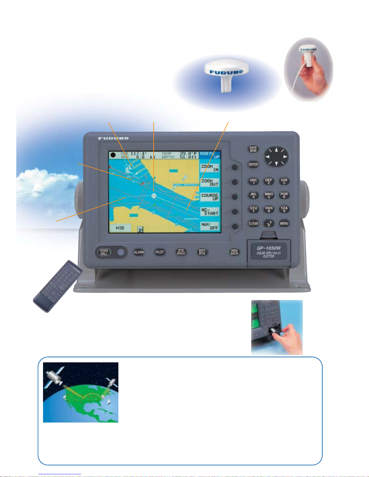
Own ship
Planned route
Own ship's
track
Harbor
Depth contours
Highly Accurate Positioning with WAAS
High Contrast Bright LCD
meeting all boaters
demands
Remote controller
(option)
Compact sensitive
GPS/WAAS antenna
WAAS is a GPS navigation system with differential correction by means of
geostationary satellites. The US FAA has been testing this system and expects more
field tests in 2003. Similar systems, using Satellite-Based Augmentation Systems
(SBAS), are under development in Japan (MSAS: MSAT Satellite-based
Augmentation System) and Europe (EGNOS: European Geostationary Navigation
Overlay System). They are said to be fully interoperable and compatible. MSAS and
EGNOS are expected to become fully operational in 2004 or after.
As the WAAS utilizes the same frequency as the GPS, a single antenna can receive GPS and WAAS signals. Currently
two Inmarsat GEO satellites are available for receiving the WAAS signal: AOR-W and POR. Major contributors of an
error in a single frequency GPS system are receiver clock drift and signal delays by refraction. The WAAS reference
stations on the earth monitor the GPS constellation and route GPS error data to the satellites via the master earth
station. The Inmarsat or communication satellite broadcasts the differential corrections to marine and aviation users.
WAAS (Wide Area Augmentation System)
Choose from two units
that accept either Furuno
MiniCharts and
Navionics
®
Nav-Chart
or C-MAPNT Charts.
GPS/DGPS/WAAS
combo antenna
Navionics®Nav-Chart
Page 3
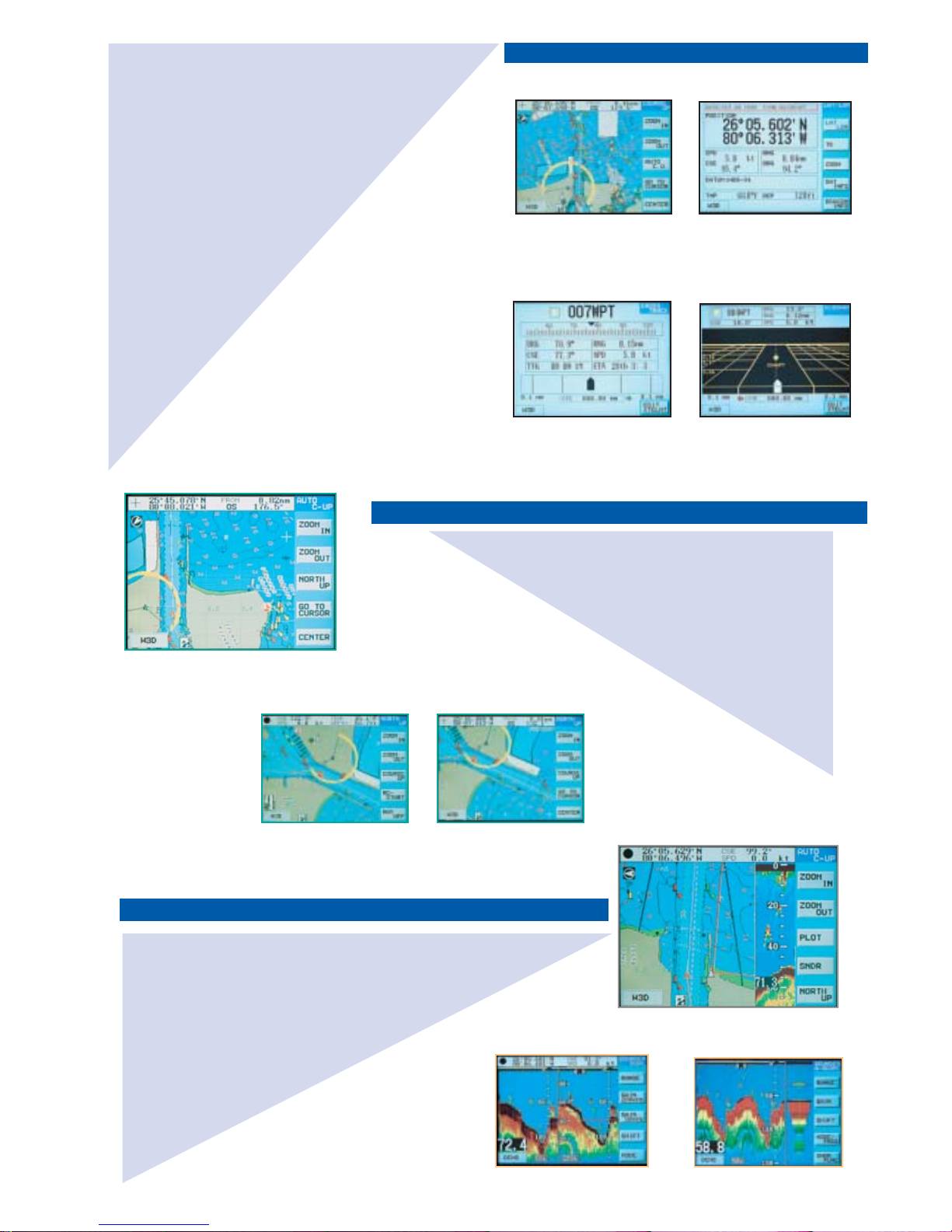
Four chart orientations are available in the course plot display:
True Motion North-up, Relative Motion North-up, Course-up and
and Auto Course-up modes. In the True Motion modes,
coastlines remain stationary on the screen while your vessel
moves according to its actual speed and course. In the Relative
Motion mode, your vessel is kept at the screen center and
coastlines move relative to your vessel.
The course plot display shows your vessel's position with a
motion trend vector, route, position, speed and course. Your
vessel's heading and speed are
indicated by a vector at your
present position. Display colors
can be changed for optimum
visibility depending on ambient
light conditions.
Echo Sounder Display (GP-1850WF/1850WDF)
Dual frequency
A-scope
(at right)
TM Course-up Mode
(Automatic)
Presentation Modes in Course Plot Display
TM North-up Mode
RM North-up Mode
Course plot + Sounder
Primary Display Modes
Course Plot
Nav Data
Steering Mode
Highway
Choice of TM North-up or
Course-up and RM North-up
or Course-up mode.
Important navigational
information can be clearly read
from a distance.
Helps you keep your vessel on
its intended course.
Useful for following legs along
your planned route.
The GP-1850W series are GPS/DGPS/WAAS plotters
with video plotting and echo sounding capability
designed for pleasure craft and coastal fishing boats.
This compact and cost-effective series offers extremely
accurate position fixes - 10 m for the basic GPS, 3 m
where WAAS service is available and 5 m with DGPS
(DGPS version).
The Display modes include Course Plot, Nav Data,
Steering and Highway. The Steering mode provides an
intuitive indication of course to steer and cross-trackerror. The Highway mode is useful when you are
following a series of waypoints along a planned route.
The GP-1850WF and GP-1850WDF with the 50/200
kHz echo sounder module present detailed information
on fish and bottom. The echo sounder data can be
displayed jointly with course plot or alone on the full
size screen.
The useable chart cards are Furuno MiniChart/
Navionics
®
Nav-Chartor C-MAPNT Chart cards.
Chart cards contain accurate spot sounding, coastlines,
depth contours, buoys, lighthouses and other
navigational features.
Incorporating a powerful 50/200 kHz, 600 W echo
sounder module, the GP-1850WF/1850WDF present
an echogram in addition to the course plot display.
Full-screen echo sounding modes include Normal
(single- or dual-freq), Bottom-lock, Bottom Zoom,
Marker Zoom and A-scope. Selection of sounding
range, phasing, gain, display mode, frequency and
other settings are simple with the softkeys at the
right of the screen. A water temperature graph can
be displayed if an appropriate temperature sensor
is provided.
In the Auto Courseup mode, automatic
resetting takes
place at a course
change of 22.5° and
the vessel's
intended course is
kept at the screen
top like a head-up
display.
C-MAPNT Chart
C-MAPNT Chart
C-MAP NT Chart
C-MAPNT Chart
C-MAPNT Chart
Page 4
GPS RECEIVER CHARACTERISTICS
1. Receiver Type Twelve discrete channels, C/A code,
all-in-view, Integral WAAS receiver processor
2. Receive Frequency L1 (1575.42 MHz)
3. Accuracy GPS: 10 m (95%)
DGPS: 5 m (95%)
WAAS: 3 m (95%)
4. Time to First Fix 12 seconds typical (Warm start)
5. Tracking Velocity 999 kts
6. Geodetic System WGS-84, NAD-27, and others
7. DGPS Capability
GP-1850WD/1850WDF: DGPS beacon receiver built in
GP-1850W/1850WF: External DGPS beacon receiver transmitting
data in RTCM SC104 v.2.1 format through
RS-232 interface or optional internal DGPS
beacon receiver
PLOTTER CHARACTERISTICS
1. Display 7 inch color LCD, 320 x 234 pixels
2. Map Scale 0.125 to 2,048 nm
3. Latitude Limits Between 85°N and 85°S
4. Plot Interval 1 s to 99 min 59 s or 0.01 to 9.99 nm
5. Display Modes Course plot, Nav Data, Steering Display,
Highway
6. Presentation Modes TM/RM North-up, Course-up
7. Memory Capacity Up to 5,000 points for ship's track points and
marks.
800 waypoints and 200 planned routes
(Max. 35 waypoints/route)
8. Voyage Planning Waypoint navigation or route navigation
9. Alarms Arrival/anchor watch, XTE, proximity alert,
ship speed, depth*, water temperature*, fish*
*GP-1850WF/1850WDF —Temperature sensor required for water temp alarm.
10. Interface (NMEA 0183 ver. 1.5/2.0)
Outputs:
AAM, APB, BOD, BWC, GGA, GLL, RMA, RMB, RMC, VTG, WPL,
XTE, ZDA, DBT*, DPT*, MTW*, MSK
Inputs:
DBT*, DPT*, MTW*, TLL, YMWPL
(YEOMAN wpt data)
*GP-1850WF/1850WDF
11. Electronic Chart FURUNO MiniChart and
NAVIONICS®Nav-Chartor
C-MAPNT Chart
ECHO SOUNDER
1. Display Modes Normal (single- or dual-frequency), Bottom-lock,
Bottom Zoom, Marker Zoom, A-scope
2. Frequency 50 and 200 kHz
3. Output Power 600 W/1 kW (specify when ordering)
4. Basic Ranges 8 basic ranges customized to max 1200 m
(4000 ft, 650 fa)
5. Range Phasing Up to 2400 m (8000 ft, 1300 fa)
ENVIRONMENTAL CONDITIONS
(IEC 60945 testing)
1. Temperature
Display Unit: -15°C to +55°C
Antenna Unit: -25°C to +70°C
2. Waterproofing
Display Unit: IPX5 (IEC 60529), CFR46 (USCG)
Antenna Unit: IPX6 (IEC 60529), CFR46 (USCG)
POWER SUPPLY
12 - 24 VDC, GP-1850W: 17 W, GP-1850WD: 19 W, GP-1850WF: 31 W,
GP-1850WDF: 33 W
EQUIPMENT LIST
Standard
1. Display Unit 1 unit
2. Antenna Unit with10 m cable 1 unit
3. NMEA Cable 5 m 1 pc
4. Installation Materials and Standard Spare PParts 1 set
Option
1. FURUNO MiniChart Card
2. Remote Controller
3. NMEA Cable 10 m
4. Antenna Mounting Base
13-QA330 (Pipe mount), 13-QA310 (Offset bracket), 13-RC5160 (Handrail mount)
5. Rectifier PR-62 for 115/230 VAC mains
6. Temperature Sensor T-02MTB/T-02MSB/T-03MSB
(GP-1850WF/GP-
1850WDF)
7. Speed/Temperature Sensor ST-02MSB/ST-02PSB
(GP-1850WF/GP-
1850WDF)
8. Internal DGPS Beacon Receiver Kit for GP-1850W/GP-1850WF
Transducers
(Specify when ordering GP-1850WF/1850WDF)
600 W
520-5PSD
(Plastic thru-hull),
520-5MSD
(Bronze thru-hull),
520-5PWD
(Plastic transom),
525ST-MSD
(Bronze thru-hull w/speed/temp sensor)
525ST-PWD
(Plastic transom w/speed/temp sensor)
1 kW
50/200-1T
(Optional matching box required)
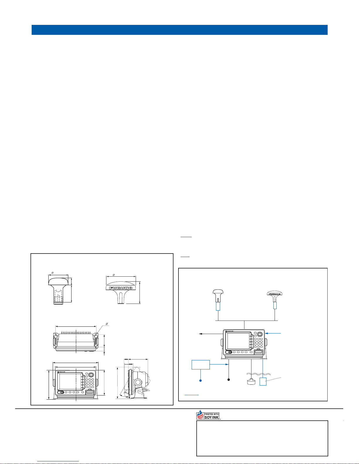
SPECIFICATIONS OF GP-1850W/1850WD/1850WF/1850WDF
05033SS Printed in Japan
SPECIFICATIONS SUBJECT TO CHANGE WITHOUT NOTICE
10 m
Optional
Antenna Base
12 to 24 VDC
Antenna unit GPA-017
Display Unit
Option
GGA,
GLL, etc.
Rectifier
PR-62
115/230 VAC
NMEA in/out
DGPS
Beacon Receiver
(GP-1850W/GP-1850WF)
Transducer
(For GP-1850WF/GP-1850WDF)
(Specify when ordering)
Temperature Sensor
T-02MTB/T-03MSB
Speed/Temperature Sensor
ST-02MSB/ST-02PSB
(GP-1850WF/GP-1850WDF)
or
(For GP-1850W/GP-1850WF)
(For GP-1850WD/GP-1850WDF)
10 m
Antenna Unit GPA-019
Optional
Antenna Base
DISPLAY UNIT
GPS ANTENNA
INTERCONNECTION DIAGRAM
259 10.2"
260 10.2"
190 7.5"
165 6.5"
18
0.7"
87
4- 6
MAX203 8.0"
31
1.2"
131 5.2"
30 1.2"
30
286 11.3"
3.4"
32 1.3"
24 0.9"61 2.4"
69 2.7"
DGPS ANTENNA
0.15 kg 0.3 lb
GPA-017
GP-1850W: 3.0 kg, 6.6 lb
GP-1850WD: 3.2 kg, 7.1 lb
GP-1850WF: 3.3 kg, 7.3 lb
GP-1850WDF: 3.4 kg, 7.5 lb
116 4.6"
156 6.1"
GPA-019
1.0 kg 2.2 lb
FURUNO U.S.A., INC.
Camas, Washington, U.S.A.
Phone: +1 360-834-9300
Fax: +1 360-834-9400
FURUNO (UK) LIMITED
Denmead, Hampshire, U.K.
Phone: +44 2392-230303
Fax: +44 2392-230101
FURUNO FRANCE S.A.
Bordeaux-Mérignac, France
Phone: +33 5 56 13 48 00
Fax: +33 5 56 13 48 01
FURUNO ESPAÑA S.A.
Madrid, Spain
Phone: +34 91-725-90-88
Fax: +34 91-725-98-97
FURUNO DANMARK AS
Hvidovre, Denmark
Phone: +45 36 77 45 00
Fax: +45 36 77 45 01
FURUNO NORGE A/S
Ålesund, Norway
Phone: +47 70 102950
Fax: +47 70 127021
FURUNO SVERIGE AB
Västra Frölunda, Sweden
Phone: +46 31-7098940
Fax: +46 31-497093
FURUNO FINLAND OY
Espoo, Finland
Phone: +358 9 4355 670
Fax: +358 9 4355 6710
FURUNO POLSKA Sp. Z o.o.
Gdynia, Poland
Phone: +48 58 669 02 20
Fax: +48 58 669 02 21
 Loading...