

Furuno 1834C-NT Operator's Manual

SIRIUS SATELLITE WEATHER
REFERENCE MANUAL
The purpose of this manual is to provide operating procedures for NavNet VX2’s
Sirius Satellite Weather capability. An optional Sirius Weather Receiver BBWX1 and
Sirius subscription are required. This manual is provided in addition to the NavNet
VX2 Operator’s Manual, which fully covers operating procedures for the NavNet
VX2 system. Sample screens are shown in landscape format. Sirius weather
coverage is curren tly avail able only in U.S. and Cana da.
Information provided by the Sirius Marine Weather service is advisory nature only.
You, the customer, agree to release FURUNO ELECTRIC CO., LTD., Si ri us Satellite
Radio Inc., Navcast Inc. and WSI Corporation from any and all claims arising from
the use of this service, and you acknowledge that you have read the terms of your
subscription agreement and agree to all the terms therein. If you do not have the
subscription agreement, you will find a copy at:
www.sirius.com/marineweatheragreement or call 1-800-869-5480 to have a copy
sent to you.
Table of Contents
1. Overview............................................................................................................2
2. Weather Display Overview..................................................................................3
2.1 Settin g up th e we at her di splay...................................................................3
2.2 Exam pl e o f wea ther display.......................................................................3
3. Weather Icons....................................................................................................4
3.1 Showing/hiding weather dat a layers...........................................................5
3.2 Weather Icons descriptions........................................................................5
4. Weather Animation..........................................................................................12
5. Weather Reports.............................................................................................13
6. Weather Menu Settings..................................................................................14
www.furuno.co.jp

1. Overview
When connect ed to the Siri us Weather Receiver BBWX1, NavNet VX2 will
display current and forec as ted weather informati on for your area. Real time
updating ens ur es t hat you have up- to-the-minute weather informati on for your
area, as well as any other area in the U.S.
Setting up th e we a th er app lic ati o n
Before you ar e able to use the weather application you will need to:
• Obtain an optional S irius Weather Receiver BBWX1.
• Obtain a Sirius w eat her s er vi c e s ubsc r iption. Contact S irius Satellite
Radio INC., for further detail s .
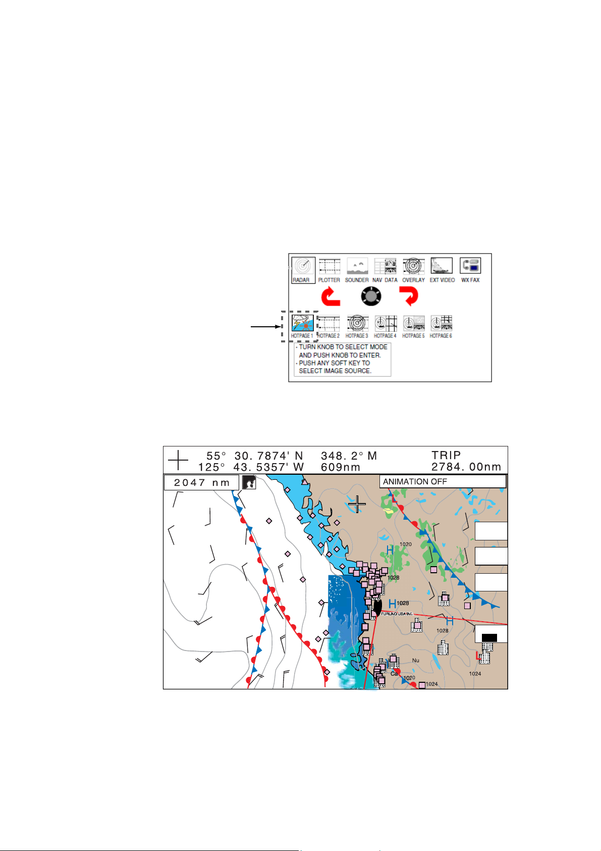
• Set up a “Hot Page” to enable access to the weather data display.
2
2. Weather Display Overview
After c onnec t ing and powering up both the B BWX1 and the ass oc iated NavNet
VX2 dis play(s), it may take up to 30 mi nutes for your Nav Net VX2 dis play to
receive/acc umulate WX data from the B BWX1.
2.1 Setting up the weather display
To enable the weather di s play, you mus t setup a hot page. Press the M E NU k ey,
then press SYSTEM CONFIGURATION, SYSTEM SETUP, HOT PAGE & NAV
DISP SETUP and HOT PAG E S ETUP soft k ey s . F ollow the on-scr een prompts .
(Refer to sect ion 7.6 in the Operator’s Manual for more detailed instructi ons .)
Note that the weather display is only avai lable as a full screen displ ay.
Weather icon
2.2 Example of we at her dis pl a y
WX
DISP
WX
PLAYER
WX
REPORT
CNTRL
WX
Exam ple of the weather display
3
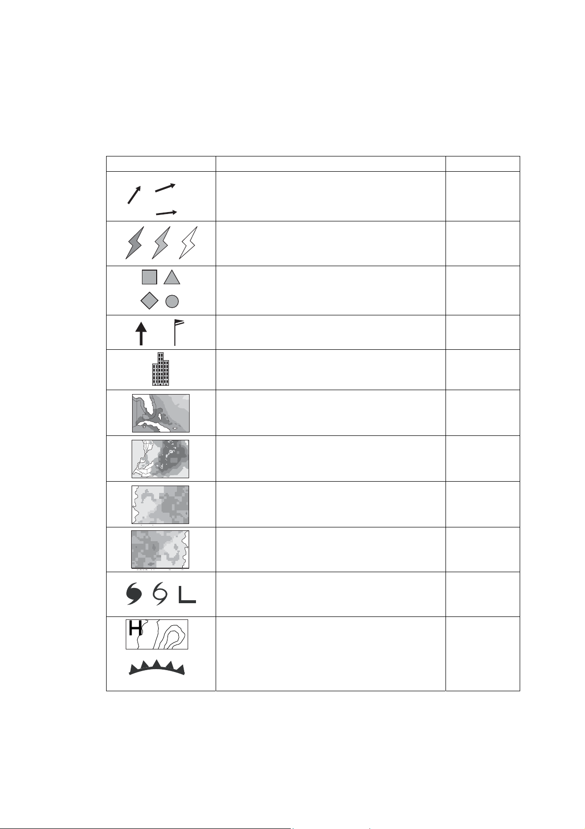
3. Weather Icons
The table below shows the weather icons that appear the Sirius S at ellite
Weather display. These icons can be shown or hidden on the WEATHER
DISPLAY window, which may be ac c ess ed wit h the WX DISP soft key. (See next
paragraph.)
Icon Color Meaning
12
20
Dark blue St or m c ast
Dark yel low (recorded in last 0-5 min. ) ,
Medium y ellow (recorded in last 5-10 min.),
Light y ellow (recorded in last 10-15 min.)
Pink
15
Lightning
Surface
observation
stations
Black (Ar row or Vane feat her ) Wind
Grey Cities
Blues Waves
CANRAD
Dark green-yellow
Green-yellow-orange
Green-yellow-red ( Rain),
Blues (Snow),
Pinks (Mixture)
Grey (Historical)
Red (Current)
Orange (Forecast)
(Canadian
radar)
Sea surface
temperature
NOWRAD
(USA
RADAR)
Storm tracks
For details, see page 10.
etc.
Surface
pressure
4
3.1 Showing/hiding weather data layers
You can choose which data to show or hide on the display as below:
1. Press the WX DISP soft key to show the weather display window.
WEATHER DISPLAY
NOWRAD (USA RADAR)
STORM CAST
SEA SURFACE TEMP
CANRAD (CANADIAN RADAR)
STORM TRACKS
LIGHTNING
OBSERVATION STATIONS
CITY FORECAST ICONS
WIND
WAVES
SURFACE PRESSURE
ALERT BOX
MARINE ZONE
COLOR SCALE
ON
ON
ON
ON
ON
ON
ON
ON
ON
ON
ON
ON
ON
ON
2. Rotate the ENTER knob or trackball to choose the weather item that you
want to show or hide.
3. Press the ENTER knob or ON/OFF soft key to choose on or off as
appropriate.
4. Repeat steps 2 and 3 to show or hide other items.
5. Press the RETURN soft key to close the window.
3.2 Weather icons descriptions
NOWRAD (USA RADAR)
NOWRAD shows the type and level of precipitation. The “Level” number shown
below is a figure of reflectivity from a weather radar. The larger the level number,
the stronger the precipitation.
Color Precipitation type Level
Light green Rain 15-19 dBz
Medium green Rain 20-29 dBz
Dark green Rain 30-39 dBz
Yellow Rain 40-44 dBz
Orange Rain 45-49 dBz
Light red Rain 50-54 dBz
Dark red Rain over 55 dBz
Light blue Snow 5-19 dBz
Dark blue Snow over 20 dBz
Light pink Mixed 5-19 dBz
Dark pink Mixed over 20 dBz
5
 Loading...