

Page 1
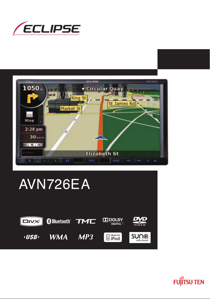
OWNER'S MANUAL
DVD-Video / USB Multi-Source Receiver / 7" Wide Screen
Monitor / Navigation / RDS-TMC (SUNA GPS Traffic
UpdatesTM) / Built-in Bluetooth ® wireless technology
We appreciate your purchase of this main unit.
Please read through this manual for correct operation.
We suggest that after reading it you keep this manual
in a safe place for future reference.
Page 2

The symbols described below are found in this instruction manual as well as on
the device itself to insure its proper and safe usage and to prevent injury or
damage to property. Make sure you understand the meaning of these symbols
before reading the rest of this manual.
Precautions for Use
The following symbols will precede information useful for preventing damage to the
main unit as well as for its smooth operation.
WARNING
This sign indicates a situation in which incorrect handling through
disregard of a sign might result in death or serious personal injury.
CAUTION
This sign indicates a situation in which incorrect handling through
disregard of a sign might result in personal injury or may result solely in
damage to property.
IMPORTANT
Follow this advice to prevent malfunctions or damage to the main unit.
Perform the indicated action in the event of a malfunction.
ATTENTION
Useful information for the smooth operation of the main unit.
CHECK
Facts to keep in mind when operating the main unit.
Please read all materials such as manuals and warranties that have come with
the product. ECLIPSE will not be responsible for unsatisfactory product
performance due to failure to follow these instructions.
Changes to product specifications may result in differences between content
of the manual and features of the product.
CAUTION
There is the possibility that the touch switches of the display screen
may not operate correctly if condensation forms inside them. In such a
case, do not attempt to operate them until the condensation has
disappeared.
Page 3

Table of Contents
Before Use
1. Safety precautions............................................................ 14
2. Viewing this Document. .................................................. 18
3. About This Receiver ......................................................... 19
Control Names and Operations........................................................................19
Panel buttons ................................................................................................................. 19
Touch switch ..................................................................................................................20
About touch switch operations ..................................................................................20
Turning the POWER ON or OFF.......................................................................21
Turn on the power ..........................................................................................................21
Turn off the audio ...........................................................................................................21
Loading/Unloading a Disc ................................................................................22
Loading a disc ................................................................................................................22
Unloading a disc.............................................................................................................23
Adjusting the Display Angle.............................................................................24
About “SD memory card” slot..........................................................................25
About Modes of this Receiver..........................................................................26
Starting each Mode ...........................................................................................27
Navigation screen........................................................................................................... 27
Audio operations screen................................................................................................. 27
About screen display ...................................................................................................... 27
Operation Conditions of this Receiver............................................................28
4. Main Unit Settings ............................................................ 29
Camera Setting ..................................................................................................29
Guide Tone Setting............................................................................................30
Color Pattern Setting.........................................................................................30
Button Illumination Setting...............................................................................31
Navi Voice Output Setting ................................................................................32
VTR Input Setting ..............................................................................................32
Screen Adjustment and Setting .......................................................................33
Picture quality adjustment screen display ......................................................................33
Switching between night picture and day picture. .........................................................34
Hiding screens................................................................................................................ 34
1
Page 4

Picture quality adjustment ..............................................................................................34
Brightness .................................................................................................................34
Color balance (only applies to Video screen)............................................................34
Color density (only applies to Video screen)............................................................. 34
ESN (Eclipse Security Network) Setting .........................................................35
ESN setting screen display ........................................................................................... 35
Operation of ESN security.............................................................................................. 36
Unlocking ESN security lock ..........................................................................................36
Cancelling ESN security.................................................................................................37
Setting display of security indicator ................................................................................ 37
5. Bluetooth Hands-Free Operation .................................... 38
Using Bluetooth Hands-Free ...........................................................................38
Hands-free screen display.............................................................................................. 38
Registering a cell phone.................................................................................................38
Registering from a cell phone ................................................................................... 39
Register by searching for cell phone on this receiver ............................................... 39
Deleting cell phone registration ...................................................................................... 40
Connecting a cell phone.................................................................................................41
Cancelling a cell phone connection................................................................................41
Making a call ..................................................................................................................42
Entering the telephone number to make the call. ..................................................... 42
Calling from call history ............................................................................................. 42
Calling from the telephone book ............................................................................... 43
Receiving a call ..............................................................................................................44
Ending a call (call refusal) ..............................................................................................44
Adjusting the ringtone volume ........................................................................................ 44
Adjusting the talking volume........................................................................................... 44
Hands-free settings ........................................................................................................45
Auto Answer settings ................................................................................................ 45
Ringtone settings ...................................................................................................... 45
Auto Connect settings ............................................................................................... 45
PIN Code setting ....................................................................................................... 45
Starting Out
1. About GPS Navigation ..................................................... 46
Before Using the GPS Navigation....................................................................46
Simple mode and Advanced mode ................................................................................46
Viewing Navigation Screen ..............................................................................46
Screen switches and other operations ...........................................................................46
2
Page 5

Operation
1. Navigation Overview ........................................................ 48
Navigation Menu................................................................................................48
Navigation Details Setting Screen ...................................................................48
Settings menu ................................................................................................................48
Quick Menu ....................................................................................................................50
Route menu....................................................................................................................51
Management menu ........................................................................................................ 51
User data management..................................................................................................52
Map screen settings .......................................................................................................52
Route planning option .................................................................................................... 53
Road Types Used for Route Planning:......................................................................54
Route calculation methods: ....................................................................................... 54
Navigation settings ......................................................................................................... 55
Regional settings............................................................................................................55
Time and Time Zone Settings ...................................................................................56
Warning settings............................................................................................................. 56
Menu settings ................................................................................................................. 57
Track log settings ..........................................................................................................57
TMC settings ..................................................................................................................58
Safety Mode settings .....................................................................................................58
Trip information screen................................................................................................... 58
Trip computer screen ..................................................................................................... 60
Screen Adjustment and Setting .......................................................................61
Day screen and night screen ......................................................................................... 61
Screen color in tunnels...................................................................................................61
Volume settings .............................................................................................................61
Map Display........................................................................................................62
Present location display ................................................................................................ 62
Cursor menu................................................................................................................... 63
Position menu................................................................................................................. 65
Checking vicinity information.......................................................................................... 65
Map menu operations..................................................................................................... 66
Map screen status information and hiding operation ..................................................... 68
Using the Cursor (at selected position) ..........................................................................72
Present location and route tracking ............................................................................... 73
Returning to normal Map screen ................................................................................... 73
Position determination (Cursor) ..................................................................................... 74
3
Page 6

Displaying original position in cursor menu ................................................................... 74
Switching to desired scale..............................................................................................74
Enabling smart zoom ................................................................................................ 75
Fine-tuning Smart Zoom ........................................................................................... 75
Driving track display .......................................................................................................75
Using logs ...................................................................................................................... 75
Recording the travelled path (creating a Track Log) ................................................. 76
Simulating a Track Log on the map ......................................................................... 76
Changing the color of a Track Log ...........................................................................77
Saving route ...................................................................................................................77
Loading saved route.......................................................................................................78
Map screen..................................................................................................................... 78
About roads .................................................................................................................... 82
3D Object types .............................................................................................................82
Managing facilities information ...................................................................................... 82
Itinerary display .............................................................................................................84
Route editing ..................................................................................................................85
Route information screen ..............................................................................................85
Facility information, storage, and revision ..................................................................... 87
Saving POIs ..............................................................................................................87
Managing POIs ......................................................................................................... 87
Managing saved search criteria .................................................................................... 87
Using Keyboard Screen ...................................................................................88
Navigation Guidance
1. Navigation Guidance ........................................................ 89
Destination Setting............................................................................................89
Setting from Map Scroll ...................................................................................89
Setting from Address........................................................................................90
Entering Address............................................................................................................90
Entering addresses for repeating house number allocation ........................................... 91
Entering address without knowing district or suburb ...................................................... 92
Selecting from intersection ............................................................................................. 93
Selecting from city center ............................................................................................... 94
Selecting from Postcode ................................................................................................95
Entering quick address...................................................................................................96
Setting from Favorites ......................................................................................96
4
Page 7

Setting from Facility Information .....................................................................96
Selecting from facility information .................................................................................. 96
Select from saved facility information search criteria .....................................................98
Setting from History..........................................................................................98
Setting from Coordinates ................................................................................98
Search Menu .....................................................................................................99
Display route (in accordance with screen) .................................................................... 99
Traffic .............................................................................................................................99
Route Search and Advanced Search ............................................................100
Creating multiple destinations (adding intermediate points) ........................................ 100
Creating multiple destinations (adding new destination) ............................................. 101
Deleting an intermediate point from the route .............................................................102
Detour menu................................................................................................................. 102
About Destination History ..............................................................................102
Managing history ......................................................................................................... 102
Deleting Destination History ..........................................................................102
Deleting active route .................................................................................................... 102
Managing saved routes ............................................................................................... 103
Managing Track Logs .................................................................................................. 103
Demonstration (Demo)....................................................................................104
Viewing a route demonstration ....................................................................................104
2. Storing Locations .......................................................... 105
Managing Favorites ........................................................................................105
3. What to Do When... ......................................................... 106
About GPS Satellite Quality and Status ........................................................106
About Speed Warnings ..................................................................................107
About Road Safety Cameras .........................................................................107
Saving road safety cameras ........................................................................................107
Camera warning .......................................................................................................... 108
Road Safety Camera types .........................................................................................108
Road Safety Camera directions ................................................................................... 109
5
Page 8

Optional Features
1. Rear View Camera Operations ...................................... 110
Imaging with the Rear View Camera..............................................................111
When camera is set to AUTO ...................................................................................... 111
When camera is set to MANUAL ................................................................................. 111
What to Do When...
1. Display of Connection Status Information .................. 113
Display of Connection Status Information ...................................................113
2. Accuracy and Error ........................................................ 114
About measurement accuracy ......................................................................114
About GPS Satellite Quality and Status .......................................................114
About Errors in Present Location Display ....................................................115
About Correction of Vehicle Position Detection by Map Matching ...........115
About Accuracy of Present Position Display and Route Guidance ..........115
About Road and Place-Name Data.................................................................117
About Route Guidance ...................................................................................117
Starting Out
1. Before Use....................................................................... 119
About Discs......................................................................................................121
Operation
1. Switching Audio Source ................................................ 124
Switching the Audio Source...........................................................................124
Display of Audio Operations Screen .............................................................124
Stopping audio mode......................................................................................124
2. Source Operations Screen............................................. 125
6
Page 9

3. Volume Control .............................................................. 127
Main Volume Control.......................................................................................127
4. Adjusting sound quality................................................. 128
Display of Audio Settings Screen..................................................................128
Adjusting audio balance.................................................................................128
Sub-Woofer Settings ......................................................................................129
Setting sub-woofer level ............................................................................................... 129
Switching the phase ....................................................................................................129
Setting low pass filter .................................................................................................. 130
Setting Loudness ...........................................................................................130
Setting Source Volume Control ....................................................................131
Adjusting Sound Quality.................................................................................132
Adjusting sound quality ...............................................................................................132
Storing sound quality....................................................................................................132
Use a preset sound quality........................................................................................... 133
5. Screen Settings............................................................... 134
Switching Between Screen Modes ...............................................................134
Other operations
1. About Remote Control ................................................... 135
Remote Control Operations............................................................................135
Precautions for use ...................................................................................................... 135
About cleaning.............................................................................................................. 135
Remote control........................................................................................................ 135
Exchanging Batteries......................................................................................136
Audio Operations
1. Using Radio..................................................................... 137
Using Radio .....................................................................................................137
Listening to Radio ...........................................................................................137
Tune a Desired Station....................................................................................137
Manual Tuning.............................................................................................................. 137
7
Page 10

Auto Tuning .................................................................................................................. 138
Selecting from preset switch ........................................................................................ 138
Selecting Radio Band......................................................................................138
Saving Station in Memory...............................................................................139
Manual saving ..............................................................................................................139
Automatic saving .......................................................................................................... 139
2. Using CD Player.............................................................. 140
Using CD Player...............................................................................................140
Listening to CD................................................................................................140
Selecting Track to Listen to............................................................................140
Fast Forwarding/Rewinding ...........................................................................141
Finding Desired Track.....................................................................................141
Repeating Same Track....................................................................................141
Random Play....................................................................................................141
3. Using MP3/WMA Player ................................................. 142
Using MP3/WMA Player ..................................................................................142
Playing MP3/WMA File ...................................................................................142
Selecting desired folder..................................................................................143
Selecting from folder list ............................................................................................... 143
Select from linked folders ............................................................................................ 144
Selecting Desired Music File..........................................................................144
Selecting from file name switch....................................................................................144
Select from linked files ................................................................................................. 145
Fast Forward/Rewind ......................................................................................145
Finding Desired Music File.............................................................................145
Repeating Music File.......................................................................................146
Random Play....................................................................................................146
About MP3/WMA..............................................................................................147
About supported MP3 file standards ............................................................................147
About supported WMA file standards ..........................................................................147
About ID3/WMA tags....................................................................................................148
About supported media types....................................................................................... 148
About format of discs.................................................................................................... 148
About file names........................................................................................................... 149
8
Page 11

Multi-sessions............................................................................................................... 150
About playing MP3/WMA ............................................................................................. 150
About MP3/WMA playing time display .........................................................................150
Creating and Playing MP3/WMA Files ...........................................................150
Downloading from MP3/WMA music sites on the Internet ...........................................150
Converting music CD into MP3/WMA files ................................................................... 151
Writing MP3/WMA files on CD-R/RW disc ...................................................................151
Playing back CD-R/RW ................................................................................................ 151
4. Using USB Music File Player ........................................ 152
Using USB Music File Player..........................................................................152
Playing USB Music Files.................................................................................152
Selecting Desired Folder ................................................................................153
Selecting from folder list ............................................................................................... 153
Select from linked folders ............................................................................................ 153
Selecting Desired Music File .........................................................................154
Selecting from file name switch....................................................................................154
Select from linked files ................................................................................................. 154
Fast Forward/Rewind ......................................................................................155
Finding Desired Music File ............................................................................155
Repeating Music File.......................................................................................155
Random Play of Music Files...........................................................................156
About USB Devices.........................................................................................156
About supported USB memory standards....................................................................156
Supported MP3 file standards ...................................................................................... 156
ID3 tags ........................................................................................................................ 156
Format of USB memory................................................................................................ 157
Visual operations
1. Before Using the DVD Player......................................... 158
Advantages of Digital Versatile Disc (DVD) ..................................................158
Multi-Audio Function..................................................................................................... 158
Multi-Angle Function..................................................................................................... 158
Subtitle Display Function.............................................................................................. 158
Discs.................................................................................................................159
Types of Playable Discs ............................................................................................... 159
9
Page 12

Region Code of Playable Disc...................................................................................... 159
Mark Indicated on Disc.................................................................................................160
Disc Configuration ........................................................................................................ 160
Products equipped with Macrovision............................................................161
Operation Flow ................................................................................................161
2. Using the DVD Player ..................................................... 162
Using the DVD Player......................................................................................162
Watching a DVD Video....................................................................................162
Video Operations.............................................................................................163
Playing a Video ............................................................................................................163
Fast Forward/Rewind ...................................................................................................163
Fast Forwarding or Rewinding Using Panel Switch ................................................163
Fast Forwarding or Rewinding Using Touch Switches............................................ 163
Pausing a Video ...........................................................................................................163
Stopping a Video .......................................................................................................... 164
Disc Menu Operations.....................................................................................164
Finding a Desired Video..................................................................................164
Finding by Chapter ....................................................................................................... 164
Finding by Title Number ...............................................................................................165
Finding by chapter number........................................................................................... 165
Changing the Touch Switch Display .............................................................166
Hiding the Touch Switch............................................................................................... 166
Relocating the Touch Switch Display ........................................................................... 166
Changing the Screen Display and Audio Mode............................................167
Changing the Angle......................................................................................................167
Changing the Subtitle Language .................................................................................. 167
Changing the Audio Language.....................................................................................168
Switching DVD setting display.......................................................................169
DVD Player Setting ..........................................................................................170
Specifying the Audio Language.................................................................................... 171
Entering the Code ...................................................................................................171
Specifying the Subtitle Language.................................................................................172
Entering the Code ...................................................................................................172
Specifying the Menu Language....................................................................................173
Entering the Code ...................................................................................................173
Setting display of multi-angle mark ..............................................................................174
Specifying the Parental Screening Level...................................................................... 174
Switching the Video Output .......................................................................................... 175
10
Page 13

Language Code List ........................................................................................176
3. Using the VTR ................................................................. 177
Using the VTR..................................................................................................177
Playing the VTR ...............................................................................................177
Changing the VTR Setting Screen .................................................................178
4. Using the DivX Player..................................................... 179
Using the DivX Player .....................................................................................179
Playing the DivX ..............................................................................................180
Video Operations.............................................................................................180
Fast Forward/Rewind ...................................................................................................180
Pausing a Video ...........................................................................................................180
Select the folder to view .................................................................................181
Select from the folder list..............................................................................................181
Select from continuous folder.......................................................................................181
Select the file to view ......................................................................................181
Select from file name switch......................................................................................... 181
Select from linked files ................................................................................................. 182
Fast Forward/Rewind ......................................................................................182
Repeating a video file......................................................................................182
Random Play....................................................................................................183
Changing the Subtitle Language ...................................................................183
Changing the Audio Language ......................................................................184
Display DivX VOD code...................................................................................185
Caution display while playing VOD Rental file .............................................186
Switching the Video Output............................................................................186
About DivX .......................................................................................................187
About the DivX standards that can be played back...................................................... 187
How to operate portable audio devices
1. Using the iPod® Player................................................... 188
Using the iPod Player......................................................................................188
Listening to the iPod.......................................................................................188
Fast Forward/Rewind ......................................................................................189
11
Page 14

Selecting the Desired Music or Video File ....................................................189
Finding a Desired Music File..........................................................................189
View the list of playing back...........................................................................190
Setting to the iPod Video Mode......................................................................191
Select the video file to view from the list ...................................................................... 191
Pausing.............................................................................................................192
Repeatedly Playing the Same Music File ......................................................192
Random Play of Music Files...........................................................................193
Listen randomly from the list that is playing ................................................................. 193
Listen to an album randomly ........................................................................................193
Listen all music files random ........................................................................................194
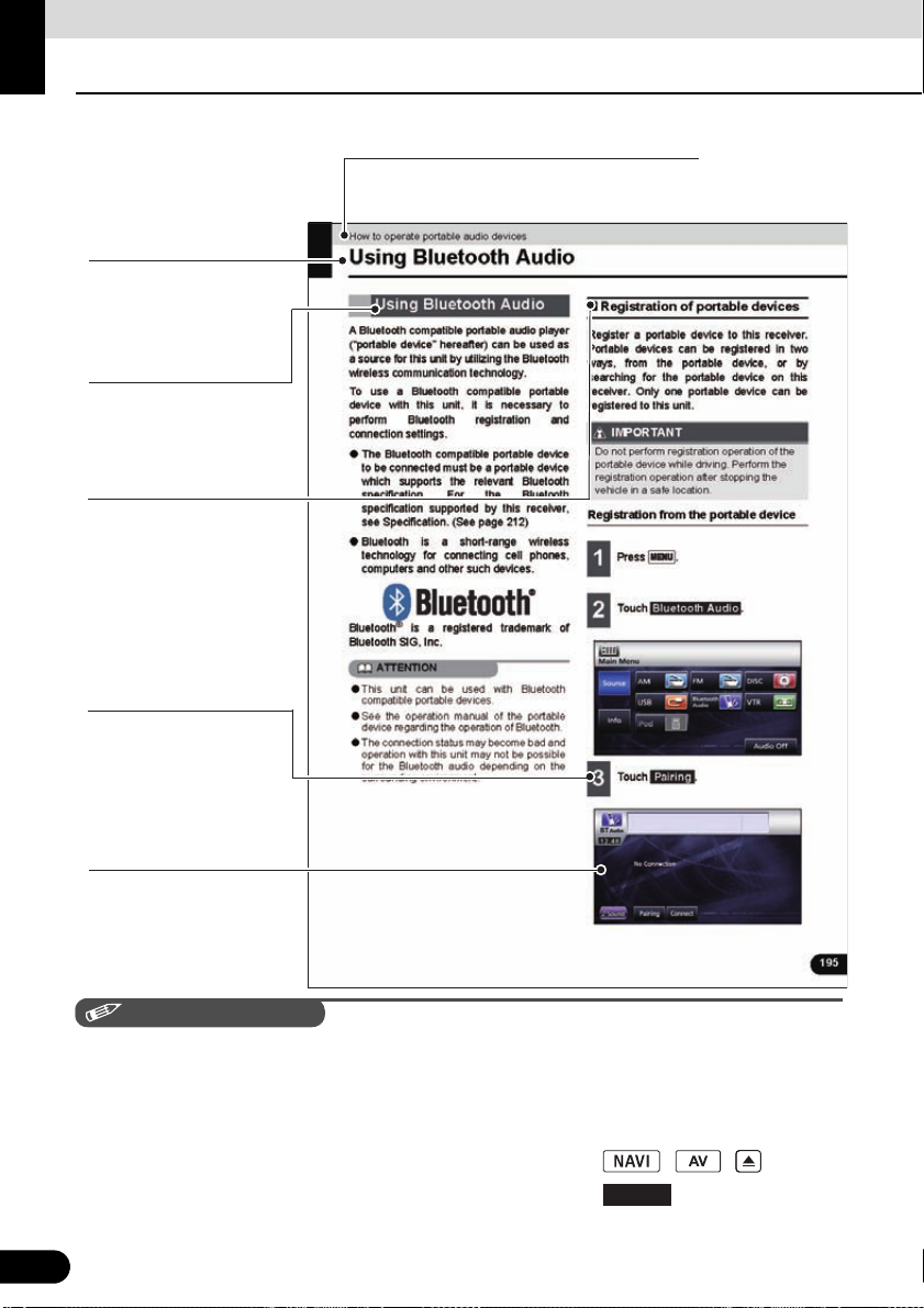
2. Using Bluetooth Audio................................................... 195
Using Bluetooth Audio....................................................................................195
Registration of portable devices ................................................................................... 195
Registration from the portable device ..................................................................... 195
Register by searching for a portable device on this receiver .................................. 196
Connection of the portable device................................................................................ 197
Cancelling a portable device connection...................................................................... 198
Listening to the portable device.................................................................................... 198
Stop the playback.........................................................................................................199
Selecting a Desired Music............................................................................................ 199
Fast forward / rewind.................................................................................................... 199
Repeating the Same Track........................................................................................... 199
Random Play................................................................................................................ 200
Others
12
1. About the Steering Wheel Switches ............................. 201
Manual setting of steering wheel switch functions......................................201
Compatibility with Steering Wheel Switches................................................203
Page 15

Reference
1. Necessary Information ................................................... 205
If the Following Messages Appear.................................................................205
When You Think There Is a Malfunction .......................................................207
2. Glossary .......................................................................... 209
3. Specifications ................................................................. 210
13
Page 16

Before Use
WARNING
Safety precautions
● Do not modify this system for any uses other than that specified herein. Also, do not deviate
from the installation procedures described herein. Eclipse will not be held liable for damages
including, but not limited to serious injury, death or property damage resulting from installations
that enable unintended operation.
● The main unit requires a 12V DC power supply. The main unit should not be installed in any
vehicle which does not have a 12 V power system with a ground-connected negative side. An
installation other than the one intended may cause severe damage to the main unit, electric
shock or personal injury.
● Never install the main unit where it will interfere with safe operation of the vehicle.
● Never block the drivers' view. Do not install the main unit where it may interfere with operation
of the brakes, the steering or safety systems, such as seat belts and air bags.
● Before drilling holes in a vehicle for installation, be sure to confirm the locations of pipes, tanks,
electrical wiring, and other vehicle systems and components to ensure that there will be no
interference or contact. In addition, apply rust prevention and leak prevention measures at the
drilling area. Otherwise, fire or electric shock could occur.
● When installing the main unit, do not remove or alter existing vehicle fasteners, including nuts,
bolts, screws, clips, and fittings. Never detach, move or alter existing vehicle wiring, including
electrical grounds and straps. Alteration of existing vehicle components may make vehicle
unsafe to operate.
● Before installation, remove the negative (-) battery terminal to prevent shocks, electrical arcing,
fires, and damage to vehicle wiring and the main unit you are installing.
● Secure wiring with non-conductive tape or plastic ties so that wires do not interfere with vehicle
operation, including the brake pedal, gear shifter and steering. Position wires so that they will
not be rubbed, abraded, or damaged by moving vehicle components, including power seats.
● To avoid damage to the main unit and vehicle, including fire, never supply power to an installed
main unit in a way that will overload the capacity of an existing vehicle circuit. Never leave a
power supply wire or connection uninsulated. Always install supplied fuses, circuit breakers,
and relays.
● Air bags are a vital part of a safety system. Never install main unit in a way which will alter air
bag wiring or interfere with air bag deployment. Air bags must function properly in the event of
an accident.
● When installation is complete, test all vehicle electrical systems to ensure they operate
correctly, including lights, horn, brake lights, and emergency flashers.
● For your protection, never use a power drill without wearing safety glasses or goggles.
Debris or broken drill bits may cause severe eye injuries, including blindness.
● Use electrical tape to insulate the ends of all wires, even if they are not used. Proper insulation
prevents arcs, shocks and fires.
● Some devices require the use of batteries. Never install main unit where young children can get
access to batteries. If a battery is swallowed, seek immediate medical attention.
● When the vehicle is in motion, never take your eyes off the road to make adjustments to the
main unit. To prevent accidents, keep your eyes on the road. Do not lose concentration on your
driving when operating or making adjustments to the main unit.
● The driver should not look at the screen while driving. Doing so may result in as accident.
14
14
Page 17

● Do not place foreign objects in the disc insertion slot or iPod/USB input terminal. Fire or shocks
may result.
● Do not disassemble or alter this main unit. Doing so may result in an accident, fire or shock.
● Do not let water or foreign objects enter the internal parts of this main unit. Doing so may result
in smoke, fire or shock.
● Do not use when main unit is malfunctioning (the screen is not lit or no sound comes out). Doing
so may result in an accident, fire or shock.
● Always replace fuses with fuses of identical capacity and characteristics. Never use a fuse with
a higher capacity than the original fuse. Using the wrong type of fuse may cause a fire or severe
damage.
● If foreign objects or water enters the main unit, smoke or a strange odor may be emitted. If this
occurs, stop using the main unit immediately and contact your dealer. Accidents, fire, or shocks
may result if you continue to use the main unit under these conditions.
● The driver should not change the Disc or iPod/USB memory while driving. Doing so may result
in as accident. You must first stop or park your car in a safe location and then proceed to
remove or insert the Disc and/or iPod/USB.
● Plastic bags and wrappings may cause suffocation and death. Keep these objects away from
babies and children. Never place bags or wrappings over anyone's head or mouth.
● Be sure to park the vehicle in a safe location and set the parking brake before watching DVDs
or videos. For safety reasons, only the sound of DVDs or videos will be emitted while the vehicle
is in motion.
15
15
Page 18

Before Use
CAUTION
Safety precautions
● Wiring and installing this main unit requires expertise and experience. Professional installation
is recommended. Consult with your dealer or a professional installation expert. Incorrect wiring
may damage the main unit or interfere with safe operation of the vehicle.
● Use only specified accessory parts. Using other parts may cause damage to the main unit or
cause parts to dislodge and fall or fly off the main unit.
● Do not install the main unit in places where it may be exposed to dew condensation (around the
air conditioning hose, etc.), or in locations where it may come in contact with water, high levels
of moisture, dust or oily smoke. If water, moisture, dust or oily smoke enters this main unit,
smoke, fires or malfunctions may result.
● Do not install in places subject to direct sunlight or where it may be hit directly by hot air from the
heater. This may increase the interior temperature of the main unit, resulting in fires and
malfunctions.
● Do not impede the air flow of the heat sink or vents of this main unit. Impeding the air flow will
cause the interior of the main unit to overheat, and fires may result.
● Connect as specified in the installation manual. If not connected correctly, fires or accidents
may result.
● Install wiring in a manner in which cables will not be pinched by movable parts such as seat
rails, and screw parts of the vehicle body. Accidents, fires and shocks may result from
disconnection and electrical shorts.
● Install wiring in a manner in which cables will not come in contact with metal parts. The wiring
may be be damaged by contact with metal parts, resulting in fire and shocks.
● Avoid all contact with hot surfaces when wiring the main unit. High temperatures may damage
wiring, causing shorts, arcing and fires.
● When changing the installation location for this main unit, please consult the dealer where you
bought it for safety reasons. Expertise is necessary for removal and installation.
● Keep volume to a reasonable level so that you can hear sounds from outside the vehicle,
including warning sounds, voices, and sirens. Failure to do so may cause an accident.
● Be careful that your hands and fingers do not get pinched when adjusting the tilting angle or
closing the display. Injuries may result.
● Do not put your hands or fingers into the disc insertion slot or iPod/USB input terminal.
Injuries may result.
● Do not touch hot parts of the main unit. Fire may result.
● The volume should be set at a moderate level to avoid hearing damage when the main unit is
powered on.
● Do not operate when sound such as distortion is being emitted.
● The main unit uses invisible laser light. Do not disassemble or alter this main unit. If any
problems occur, contact the dealer where you purchased the main unit. Altering this main unit
may cause exposure to laser emissions (which may damage your eyesight), or result in an
accident, fire or shocks.
● If the main unit is dropped or the front panel is damaged, turn off the power to the main unit and
contact your dealer. If used in this condition, fires or shocks may result.
16
16
Page 19

IMPORTANT
● When there is a lot of vibration – when driving on a bad road for example – the main unit may
become inoperable due to it not being able to read data from the disc.
● In cold temperatures, condensation may accumulate on the lens for readings CDs and DVDs
immediately after turning ON the heater. Wait approximately 1 hour for the condensation to
evaporate and the device will operate normally.
Contact the store where you purchased the device if normal operation does not resume after
several hours.
● If using this receiver immediately after having purchased it or after having stored it
disconnected from the vehicle battery, the present location may not be displayed accurately.
Wait a short while and the GPS positioning will correct the displayed position.
● This device is precision-engineered equipment and the information that you record on it after
purchase can be lost as a result of static electricity, electrical noise, vibration and other
influences. It is recommended that you keep a separate record of the information you store in
the main unit.
● Note that the following events are not covered by the warranty.
a Corruption or loss of the data stored in the main unit by the purchaser resulting from failure or
incorrect operation of the main unit, or any problems associated with it, or due to the effects
of electrical noise or other influences.
b Corruption or loss of the data stored in the main unit by the purchaser resulting from misuse
of the main unit by the purchaser or a third party.
c Corruption or loss of data stored in the main unit by the purchaser resulting from failure/repair
of the main unit.
* Please note that by installing or using the main unit, you are regarded as having consented to
the points above.
17
17
Page 20
Before Use
CHECK
A title is assigned for each section.
Section title
A title is assigned for
each operation .
Operation title
A number and title is
assigned for each
item.
Item title
A screen showing
the operation will
appear.
Operation screen
A title is assigned for
each detailed
operation.
Detailed operation
title
Describes the
operation.
Proceed with the
operation as per the
numerical order.
Operation procedure
○○○
Viewing this Document.
In this document, the main unit is generally described using the screens which appear when the
optional devices are connected.
Navigation is mostly described using the North - upwards 1 screen.
About switch display.
When a panel button is to be pressed, button names are shown as ( , , etc.).
When a touch switch is to be touched, switch names are shown as or [ccc].
18
18
Page 21
Before Use
About This Receiver
Control Names and Operations
You can operate this receiver by pressing the buttons (panel buttons) or by touching the
switches displayed on the screen (touch switches).
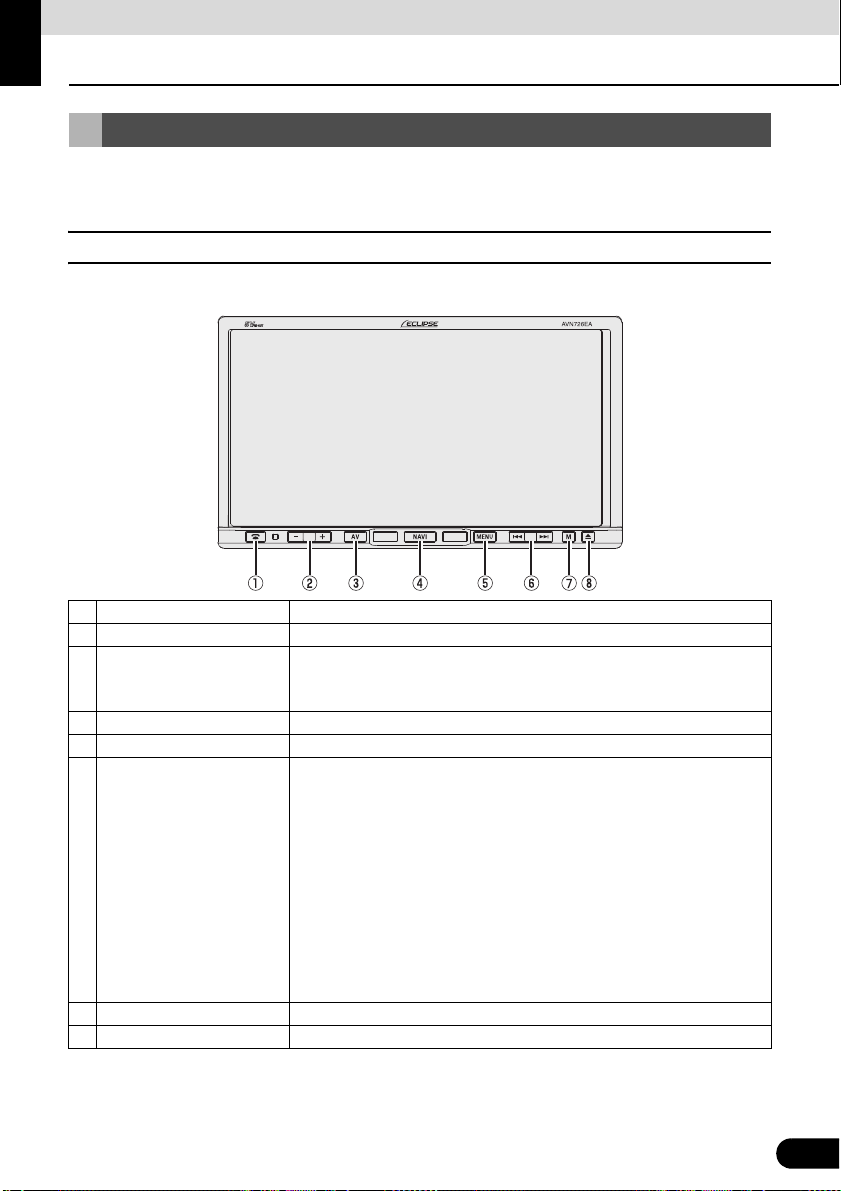
■ Panel buttons
Press each panel button to operate it.
a Phone button Press to make a telephone call.
b VOL button Press to adjust volume of audio.
Press to display the audio operation screens.
c AV button
d NAVI button Press to display the navigation menu screen.
e MENU button Press to display the (audio/info) menu screen.
f TUNE/TRACK button
g MUTE button Press to mute sound.
h OPEN/TILT button Press to open display or adjust angle of screen.
Press to adjust the screen image quality or screen brightness. (Press for
1 second or more)
For radio mode:
Press to select station manually.
Press to select station automatically. (Press for 1 second or more)
For CD, MP3/WMA, USB, and iPod mode:
Press to select a track or music file.
Press to fast forward or fast reverse track or music file. (Press for 1
second or more)
For DVD, DivX, and iPod-video mode:
Press to select videos or chapters.
Press to fast forward or fast reverse videos and chapters. (Press for 1
second or more)
19
19
Page 22
Before Use
IMPORTANT
About This Receiver
■ Touch switch
Touch the switches on the screen to operate.
Touch the touch switches with your finger.
Operating touch switches with the point of hard objects such as ballpoint pens or mechanical
pencils can damage screen.
Touch switch
About touch switch operations
● Keep touching the touch switch until “beep” is emitted in response. (When guide tone is set
to ON.)
● To protect the screen, touch the touch switch lightly with your finger.
● When there is no response from switch, remove your finger from the screen and touch
again.
● Disabled touch switches have their color toned down.
● When the switch function is enabled, the switches return to brighter colors.
20
20
Page 23
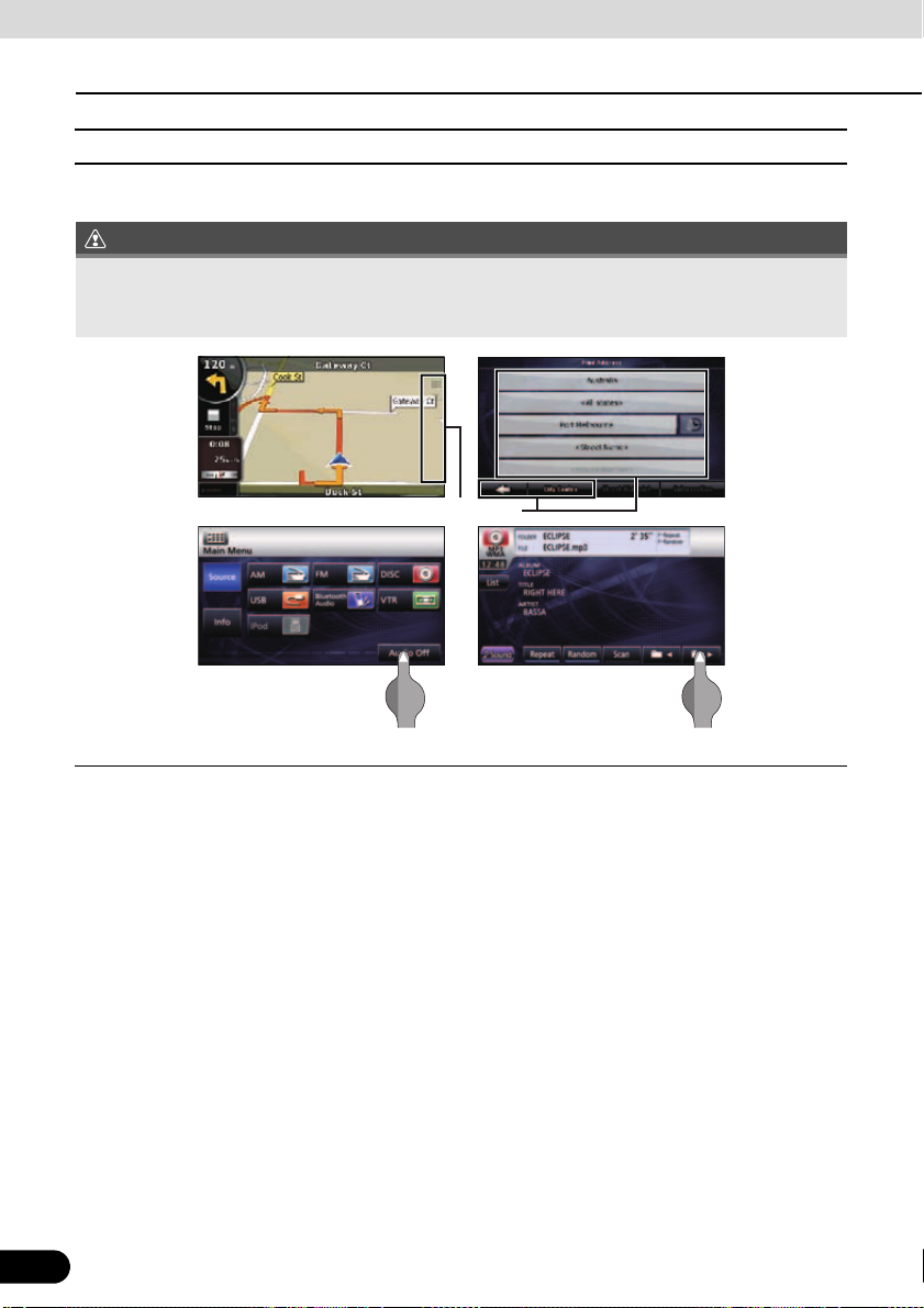
ATTENTION
Turning the POWER ON or OFF
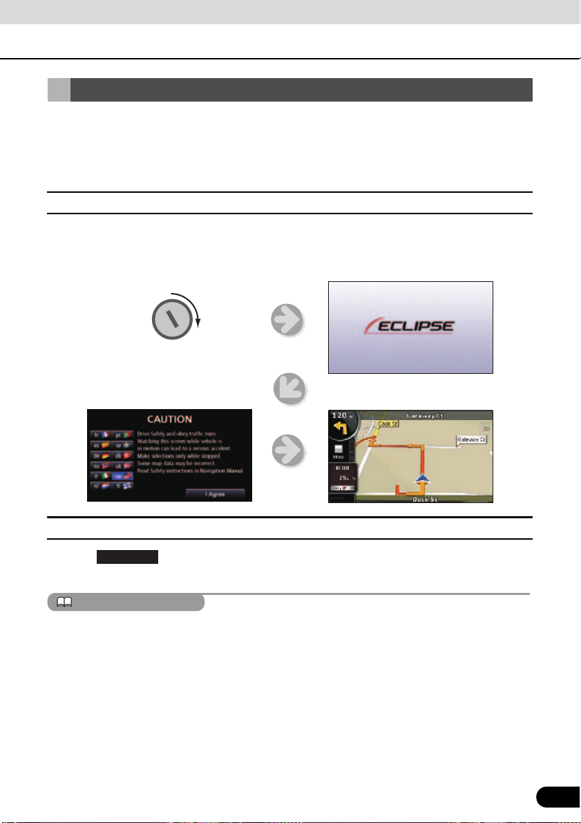
<Openingscreen>
Enginekey
<Navigationscreen>
<Cautionscreen>
At ignition, this receiver automatically switches on and displays the Navigation screen*. When
the engine is switched off, this receiver switches off.
* The Navigation screen displays your present location. The Audio operations screen displays
screen of audio source that was playing on last use.
■ Turn on the power
The Caution screen is displayed automatically. After selecting a language, touch [ I Agree ] to
display the Navigation screen.
■ Turn off the audio
● Touch on the Menu screen
● To turn off the audio power when the Navigation screen is displayed, first switch to the Source
● When the audio power is turned off, touch the source you wish to change to on the Source
● You cannot turn off the navigation power.
21
Audio Off
(If you are on the Navigation screen, switch to the Menu screen to do this.)
screen,
screen. For details, see
“Switching the Audio Source” on page 124.
21
Page 24
Before Use
IMPORTANT
CAUTION
CLOSE
DISC
About This Receiver
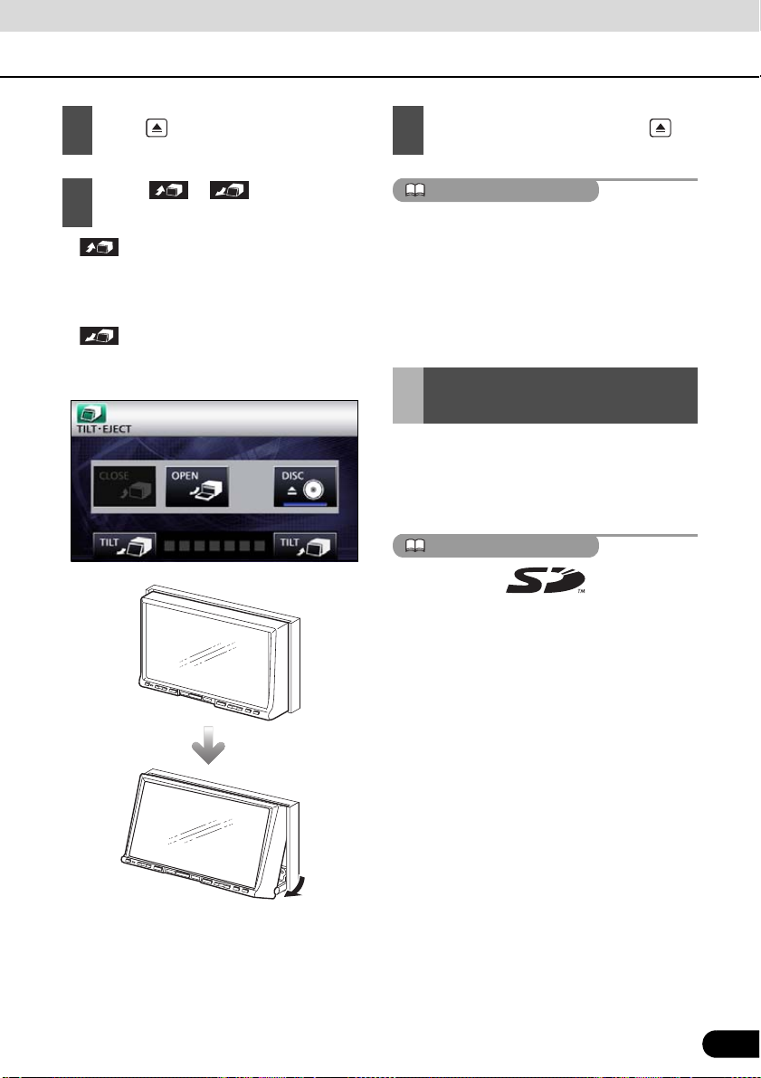
Loading/Unloading a Disc
When you listen to music, insert a CD into the
drive slot. Also, when you play a movie, insert
its DVD into the slot.
■ Loading a disc
This receiver can play 8cm CDs and 8cm
DVDs. To avoid disc problems, insert a disc
without using an adapter.
● You may not be able to open or close the
display when the gearshift lever is set to P
in an automatic transmission car or 1/3/5
or r in a manual transmission car; or
when a bottle or a similar object is placed
in the cup holder. To open or close the
display safely, set the gearshift lever to N
(automatic transmission car) or to the
Neutral position (manual transmission car)
in advance, or empty the cup holder. Make
sure that the car is not in motion by
applying the parking brake and
appropriately stepping on the foot brake in
order to prevent damage or injury.
● Do not place a cup or can on the display
while the display is opened. Doing so may
damage the display.
● When a disc is loaded, do not press
or .
Press .
1
Touch .
2
● The display will open to reveal insertion
slot.
Disc slot
22
22
Page 25
ATTENTION
IMPORTANT
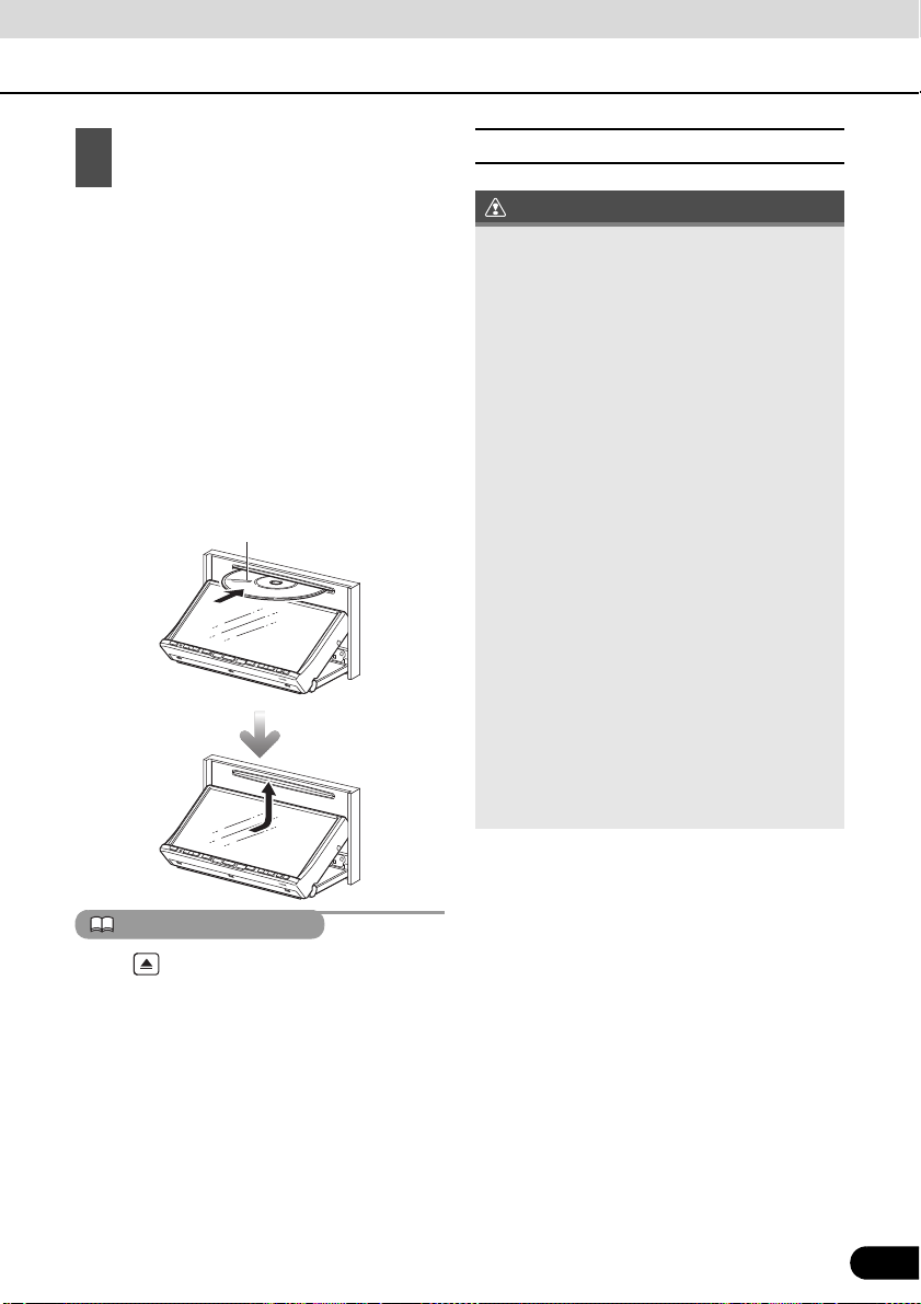
Insert a disc into the slot.
Disc
3
● The display will close automatically when
the disc is inserted.
● Hold a DVD or CD correctly (by inserting
your finger in its center hole and by holding
the disc edge by another finger), face the
disc label side upward, and insert the disc
into the slot.
● When you insert a DVD into slot, its movie
will be played in the DVD mode.
● When you insert a CD into slot, its music
will be played or the MP3/WMA play will
start.
■ Unloading a disc
● When unloading a disc, use the following
notes.
Automatic transmission (AT) car:
If it is difficult to unload disc when the shift
lever is in the P position, shift it to the N
position. (If your car has a column shift
lever, shift it to the P or N position.)
Manual transmission (MT) car:
If it is difficult to unload disc when the shift
lever is in “1”, “3”, “5” or “r” position, shift it
to the Neutral position.
● Take care NOT to close the display when
the ejected disc remains in the slot. If this
caution is not observed, this receiver or the
disc may be scratched.
● Do not attempt to close the front panel by
hand. Doing so may damage the display.
● Do not put cups, cans, or any other objects
on the display when it is open. Doing so
may damage the display.
● Wipe and clean the display immediately if
juice or other liquid spills onto it. If it is not
cleaned, the display may be damaged.
● To protect the display from heat and dust,
keep the display closed except when you
load or unload a disc.
Press for a second or more to open the
display.
23
23
Page 26
Before Use
CAUTION
IMPORTANT
CLOSE
About This Receiver
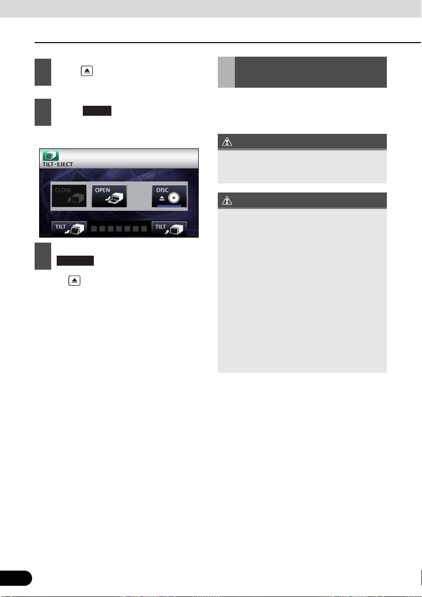
Press .
1
Touch .
2
● The disc will be ejected automatically.
3
● Press to close the display.
DISC
After removing the disc, touch
.
Adjusting the Display Angle
When the screen shines due to ambient
sunlight, you can adjust the angle of the
display.
When adjusting its angle, take care not to
pinch your fingers. Otherwise you may hurt
yourself or the display may fail.
● Do not load a disc when the display is
tilted. If this caution is not observed, this
receiver or the disc may be scratched.
● When adjusting the display angle, use the
following notes.
Automatic transmission (AT) car:
Adjust the display angle so as not to get in
the way when shifting the AT lever to any
of the P, r, or N positions. (If the lever shift
is interfered with, do not tilt the display.)
Manual transmission (MT) car:
Adjust the display angle so as not to get in
the way when shifting the MT lever to any
of the 1/3/5 or r positions. (If the lever
shift is interfered with, do not tilt the
display.)
24
24
Page 27
ATTENTION
ATTENTION
Press .
1
Touch or of the angle
2
adjustment.
● :
Each touch returns the display from the
tilted state by 1 step (5°). (Maximum 7
steps, 35°)
● :
Each touch tilts the display by 1 step (5 °).
(Maximum 7 steps, 35°)
After adjusting the angle, press
3
● You can open the display even when it is
tilted. When you close the display, it returns
to the preset angle.
● If you tilt the display and turn the ignition key
OFF, the display will return to the upright
position. However, when you turn the
ignition key to the ACC or ON position, the
display returns to the preset angle.
About “SD memory card” slot
● “SD memory card” slot of this unit is used
for map update.
● Once all our map update service are set,
we will announce it on our homepage.
SD Logo is a trademark.
25
25
Page 28
Before Use
1 2
3
About This Receiver
About Modes of this Receiver
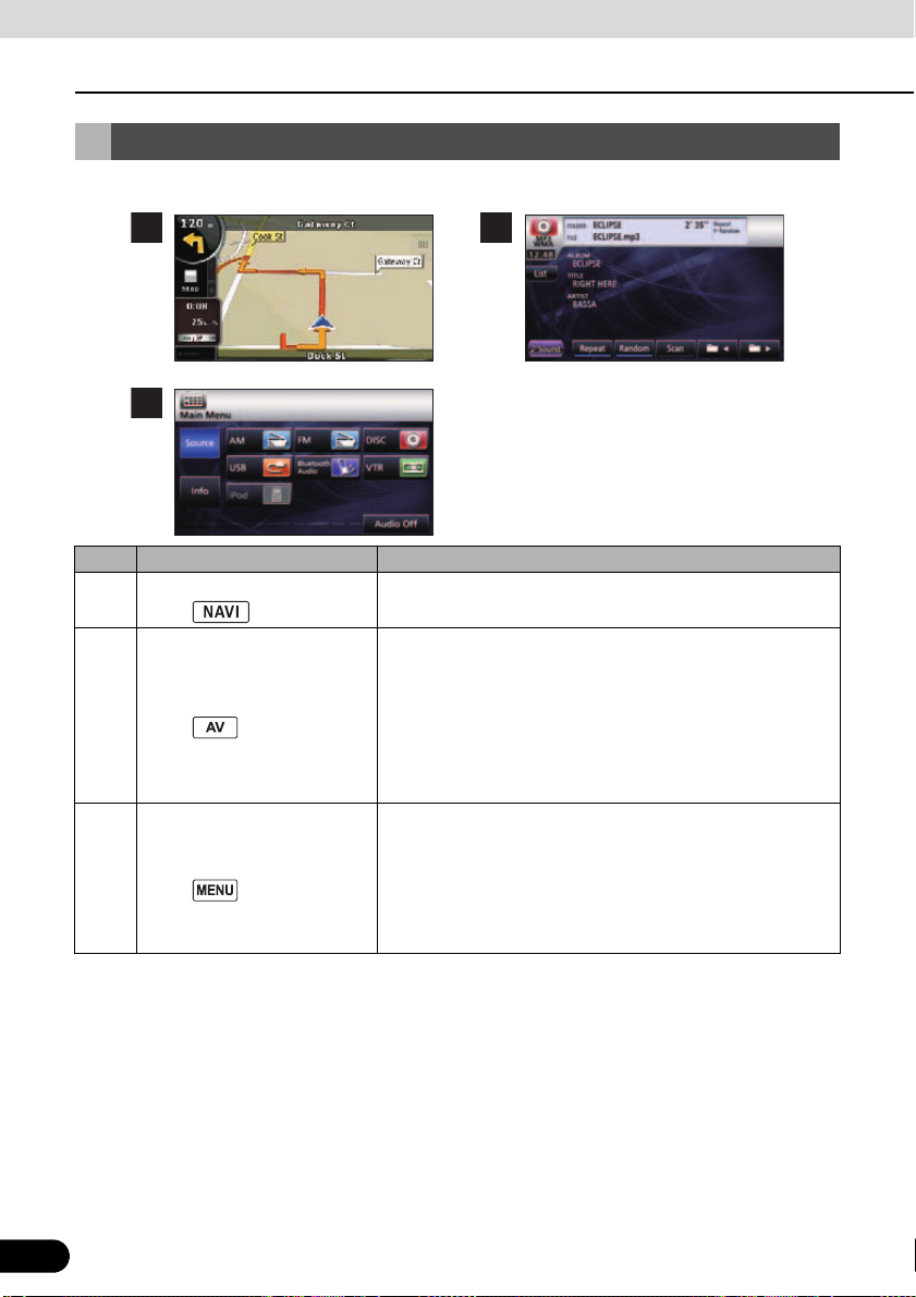
The main modes of this receiver are MENU, Navigation, and Audio.
Mode Main functions
Navigation
1
(press )
Audio
2
(press )
Main menu
3
(press )
* Some of these functions cannot be used when driving.
● Display navigation menu screen
● Set destination, guidance
● Receive AM/FM radio
● CD, MP3/WMA player operations
● Bluetooth audio player operations
● DVD/DivX player operations
● Display VTR video
● iPod operations
● Picture quality adjustment
● Displays audio menu
Change audio source
● Displays information menu
ESN setting
Steering mode switch setting
Rear View camera setting
26
26
Page 29
ATTENTION
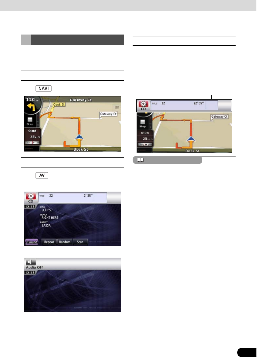
Starting each Mode
■ About screen display
Press the following switches to switch among
screens.
■ Navigation screen
Press .
■ Audio operations screen
Press .
*1
(when operating as CD player)
.
If DISC is loaded or USB or iPod is connected
while the Navigation screen is displayed, the
screendisplay will appear.
After a short time, the screen display
disappears automatically.
Screen display
When the iPod is disconnected, a screen
corresponding to the audio source of the
preceding mode is displayed.
(OFF screen)
*1 Displayed when audio function is in
operation. For audio operations, see
“Switching the Audio Source” on page
124
*2 Displayed when audio function is OFF.
27
*2
.
27
Page 30
Before Use
ATTENTION
About This Receiver
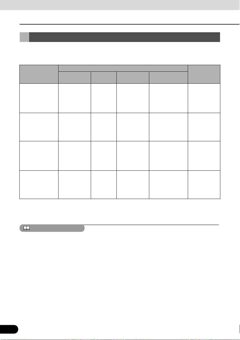
Operation Conditions of this Receiver
You can or cannot operate this receiver in the following conditions (the ignition key positions).
c: Operable; ×: Inoperable
Engine switch Display open
Function
Navigation/
settings and
information
Audio function × cc
Video function × cc
Loading and
unloading of DISC
and “SD memory
card”/Display
angle adjustment
Turns OFF ACC
× cc
After switching
the engine
OFF, the
display can be
closed.
cc c
*1 When parking brake is on.
*2 When safety mode is set to on.
*3 Video not displayed.
ON, vehicle at
*1
rest
ON, vehicle in
motion
When the vehicle
is in motion, some
functions become
inoperable for
safety reasons*2.
When the vehicle
is in motion, some
functions become
inoperable for
safety reasons.
When the vehicle
is in motion, some
functions become
inoperable for
safety reasons*3.
×
×
×
Display angle
cannot be
adjusted
Disabled switches are toned down in color and inoperable. Operating an inoperable switch when
the vehicle is in motion may result in the display of an operation prohibited message.
28
28
Page 31

Before Use
Setting
Done
Main Unit Settings
Besides settings for navigation and audio operations, the following settings can be made.
● Rear View Camera Setting (See page 29)
● Guide Tone Setting (See page 30)
● Color Pattern Setting (See page 30)
● Button Illumination Setting (See page 31)
● Navi Voice Output Setting (See page 32)
● VTR Input Setting (See page 32)
● Steering Remote Setting (See page 201)
● Screen Adjustment and Setting (See page 33)
● ESN (Eclipse Security Network) Setting (See page 35)
Camera Setting
Set the camera to the AUTO or MANUAL
operation mode.
AUTO is to switch to the camera picture when
back gear is selected. MANUAL is to switch
to camera picture when is
touched.
Press .
1
Info
Touch .
2
Camera Screen
Touch .
3
Auto Manual
Touch or .
4
● On completion, touch to store the
setting and return to the immediately
preceding screen.
29
29
Page 32

Before Use
ATTENTION
On
Info
Main Unit Settings
Guide Tone Setting
You can set the “beep” sound issued on
pressing the panel buttons and touching the
touch switches.
Press .
1
Info
Touch .
2
Setting
Touch .
3
Touch either or (mute) to
4
set the guide tone.
● On completion, touch to store the
setting and return to the immediately
preceding screen.
The guide tone is outputted from all speakers.
Off
Done
Color Pattern Setting
You can set the color pattern of the screens.
Press .
1
30
30
Touch .
2
Page 33

Touch .
Setting
123
4
5
Done
Info
Setting
3
Touch , , , , or
4
● On completion, touch to store the
setting and return to the immediately
preceding screen.
to set the color pattern.
Button Illumination Setting
You can set the button illumination.
Press .
1
Touch .
2
Touch .
3
31
31
Page 34

Before Use
Blue
Red
Done
Setting
Front L
Done
Main Unit Settings
Touch or .
4
● On completion, touch to store the
setting and return to the immediately
preceding screen.
Navi Voice Output Setting
Select the Right or Left navigation voice
channel.
Press .
1
Info
Touch .
2
Touch .
3
Touch or .
4
● On completion, touch to store the
setting and return to the immediately
preceding screen.
Front R
VTR Input Setting
32
32
Set the video signal.
Auto automatically selects NTSC or PAL.
Press .
1
Page 35

CHECK
Touch .
Info
Auto
PAL
Done
Done
2
Touch .
3
Setting
Screen Adjustment and Setting
To make it easier to view the screen, switch
between Day and Night based on whether
the lights (sidelights, tail lights, license plate
light) are on or off.
In some vehicles, this receiver may be unable
to detect whether lights are on or off. In this is
the case, manually switch between Day and
Night.
■ Picture quality adjustment screen display
The Picture quality adjustment screen can be
opened from the Navigation screen, the Audio
operations screen or the Video screen.
Press for at least 1 second.
1
Touch , or .
4
● On completion, touch to store the
setting and return to the immediately
preceding screen.
33
NTSC
On completion of the adjustment,
2
touch .
● For adjustments, see “Picture quality
adjustment” on page 34.
● When no operation is performed for
around 20 seconds, this receiver selects a
setting automatically and returns to the
preceding screen.
● For the Navigation screen and Audio
screen.
33
Page 36

Before Use
ATTENTION
Day
+
−
G
R
−
Main Unit Settings
● For the Video screen.
■ Switching between night picture
and day picture.
When night picture is displayed, touch
1
● On each touch, the display switches
between the night picture and the day
picture.
.
■ Picture quality adjustment
You can adjust the day picture and night
picture independently.
● For the Navigation screen and Audio screen.
34
When the power is switched on, the panel
buttons are constantly lit.
■ Hiding screens
Touch on the Picture quality
1
● To bring back the screen, press or
34
Off
adjustment screen.
.
● For the Video screen.
Brightness
To increase brightness, touch .
1
To decrease, touch .
● The initial setting for when the lights are
switched off is the maximum value
(brightest state).
Color balance (only applies to Video
screen)
To strengthen green, touch . To
1
strengthen red, touch .
Color density (only applies to Video
screen)
To darken color touch . To
1
lighten, touch .
+
Page 37

CHECK
ESN (Eclipse Security
Info
ESN
Network) Setting
■ ESN setting screen display
This receiver has a built-in ESN (ECLIPSE
Security Network function. ESN is a security
system which renders the navigation and
audio functions inoperable when the battery
terminal is disconnected and reconnected.
You can make the security indicator flash
when the security system is in operation.
INDICATOR
To operate ESN, register a music CD as a
key CD in this receiver.
● The flashing of the security indicator works
to discourage theft.
● A DVD or MP3/WMA disc cannot be
registered as the key CD.
● When setting the security on this receiver,
register a music CD. Be sure to store the
registered music CD somewhere safe.
● When setting the security, the audio is
turned OFF.
Press .
1
Touch .
2
Touch .
3
● The ESN setting screen is displayed.
35
35
Page 38

Before Use
ATTENTION
NO
YES
Main Unit Settings
■ Operation of ESN security
When ESN security is in operation, the
navigation and audio functions of this
receiver become inoperable when it is
disconnected and subsequently reconnected
to the battery terminal of the vehicle.
Go to the ESN setting screen, load a
1
music CD into the disc insertion slot.
● For disc insertion, see “Loading/Unloading
a Disc” on page 22.
The registered music CD is required when
unlocking the security. It is recommended to
make a note of the registered music CD to
remind you of which music CD is registered.
■ Unlocking ESN security lock
When you disconnect and then reconnect the
battery terminal, the Program reading screen
and the Opening screen are displayed first,
followed by the Security screen.
Setup
Touch .
2
Touch .
3
● The security system is now [ON].
● Touch to cancel the security setting
and return to the preceding screen.
YES
Insert the registered music CD in the
1
disc insertion slot.
● For disc insertion, see “Loading/Unloading
a Disc” on page 22.
Touch .
2
● This receiver verifies the inserted CD
against the registered information, and
unlocks the security on completion of the
verification.
36
36
Page 39

ATTENTION
● If the music CD cannot be verified, you can
CHECK
Cancel
YES
Indicator
Done
make a maximum of five attempts to unlock
the security. When verification fails, the
Customer enquiries screen is displayed.
● When the Customer enquiries screen is
displayed, you can no longer operate this
receiver. Please contact Eclipse Australia
1800 211 411.
■ Cancelling ESN security
To reapply the ESN security after cancelling,
repeat the process of registering a music CD.
See “Operation of ESN security” on page 36
Go to the ESN setting screen, load a
1
music CD into the disc insertion slot.
● For disc insertion, see “Loading/Unloading
a Disc” on page 22.
Touch .
2
■ Setting display of security indicator
You can select whether to use the security
indicator which flashes when ESN security is
in operation.
You cannot set the indicator unless you have
registered a music CD in this receiver.
Touch on the ESN setting
1
screen.
Touch .
2
3
37
Touch .
37
Page 40

Before Use
IMPORTANT
Bluetooth Hands-Free Operation
Using Bluetooth HandsFree
This receiver uses Bluetooth wireless
technology to enable use of Bluetoothsupported cell phones. Connection with this
receiver allows you to make calls without
touching your cell phone. To use a Bluetoothsupporting cell phone with this device, it is
necessary to perform Bluetooth registration
and connection settings.
● The Bluetooth-supported cell phone to be
connected must be a cell phone which
supports the relevant Bluetooth
specification. For the Bluetooth
specification supported by this receiver,
see Specification (See page 210).
● Bluetooth is a short-range wireless
technology for connecting cell phones,
computers and other such devices.
®
Bluetooth
Bluetooth SIG, Inc.
is a registered trademark of
■ Hands-free screen display
Press .
1
● The hands-free screen is displayed.
● When a call is in progress, finish the call
before pressing .
● Hands-free screen
■ Registering a cell phone
Do not register a cell phone while driving. Be
sure to park the vehicle in a safe location and
register a cell phone.
a Reception indicator
b Battery indicator
38
38
Register a cell phone on this receiver. Cell
phones can be registered in two ways, from
the cell phone, or by searching for the cellphone on this receiver. Up to 5 cell-phones
can be registered. The order of connection
precedence is always 1 to 5. When a cell
phone is added or deleted, the order of
connection precedence is renewed.
Page 41
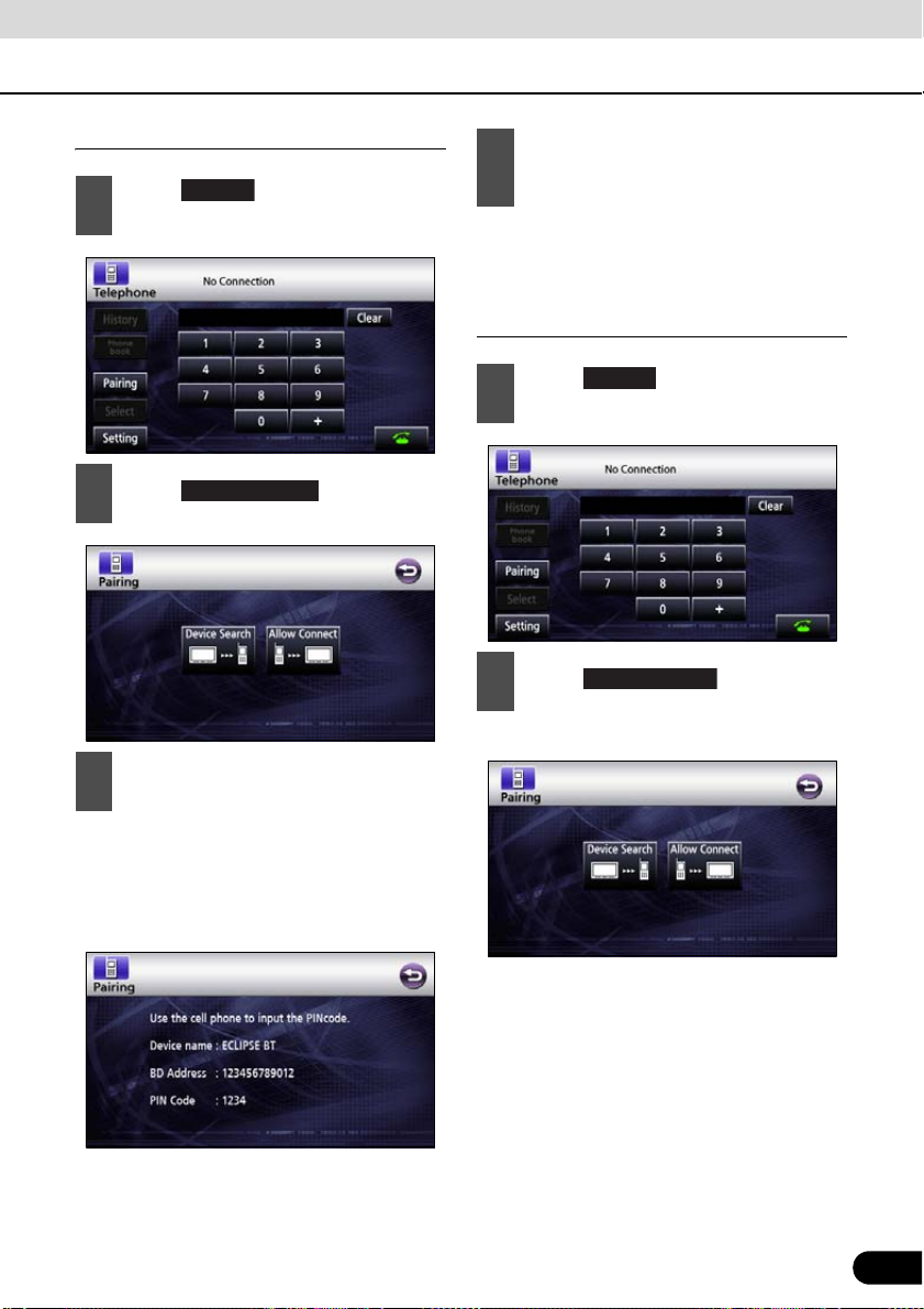
Registering from a cell phone
Pairing
Allow Connect
Device Search
Touch on the Hands-free
1
screen.
Touch .
2
On the cell-phone, enter PIN CODE
3
for this receiver.
“Bluetooth Connection Successful” is
4
displayed on completion of
registration.
● Registration of the cell phone is now
complete.
Register by searching for cell phone on
this receiver
Pairing
Touch on the Hands-free
1
screen.
Touch .
2
● “Searching...” is displayed.
● The name of this receiver is ECLIPSE BT.
● The default PIN CODE setting is 1234.
● Perform the cell phone operations with the
Device information screen displayed.
● Device information screen
39
39
Page 42

Before Use
ATTENTION
ATTENTION
Select
Bluetooth Hands-Free Operation
Select the device name of the cell
3
phone you wish to register
● Search screen
Enter the PIN CODE on the cell
4
phone.
● The default PIN CODE setting is 1234.
● Perform the cell phone operations with the
Device information screen displayed.
■ Deleting cell phone registration
Delete a cell phone registered on this
receiver.
Touch on the Hands-free
1
screen.
Select the cell-phone for deletion
2
40
● Device information screen
“Bluetooth Connection Successful” is
5
displayed on completion of
registration.
● Registration of the cell phone is now
complete.
● When registration fails, “Bluetooth
Connection Failed” is displayed. In this case,
repeat the registration operations.
● For cell phone-side operations, consult the
instruction manual that came with your cell
phone.
40
Delete
Touch .
3
“Bluetooth Connection Successful” is
4
displayed on completion of deletion.
● Deletion of the cell phone is now complete.
When a cell phone registration is deleted, all
call histories and contact data stored on this
receiver are also deleted.
Page 43
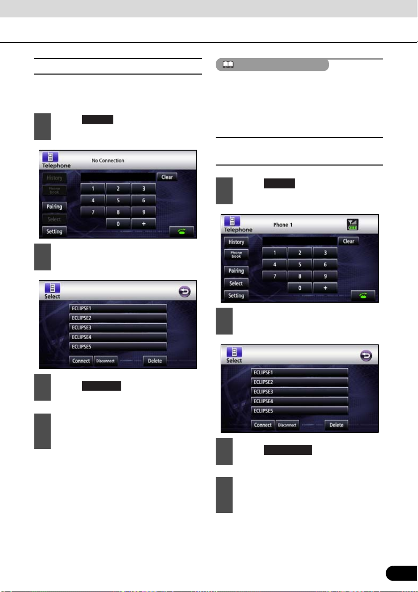
■ Connecting a cell phone
ATTENTION
Select
Connect a cell phone registered on this
receiver.
Select
Touch on the Hands-free
1
screen.
Select the cell-phone for connection.
2
● When connection fails, “Bluetooth
Connection Failed” is displayed. In this case,
repeat the connection operations.
● Note that you cannot connect unregistered
cell phones.
■ Cancelling a cell phone connection.
Touch on the Hands-free
1
screen.
Select the cell phone for which to
2
cancel connection.
Connect
Touch .
3
“Bluetooth Connection Successful” is
4
displayed on completion of
connection.
● Connection of the cell phone to this
receiver is now complete. (The reception
indicator and battery indicators are
displayed on the screen.)
41
Disconnect
Touch .
3
“Bluetooth Connection Successful” is
4
displayed on completion of
cancellation.
● Connection cancelation for the cell phone
is now complete. (The reception indicator
and battery indicator disappear from the
screen.)
41
Page 44
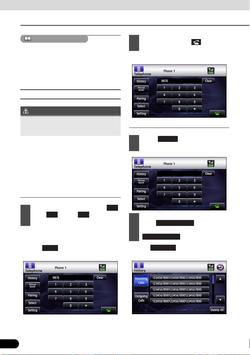
Before Use
ATTENTION
IMPORTANT
1
Incoming Calls
Delete All
Bluetooth Hands-Free Operation
On completion, touch .
If the vehicle's battery is disconnected (for
repairs to the vehicle or for removing this unit),
all the Registered cell-phone, phone book and
all call history in the memory will be lost. In
such a case, redistilling cell-phone in the
memory again.
■ Making a call
2
● A call is made to the entered number.
Do not make a call while driving. Be sure to
park the vehicle in a safe location and make
a call.
You can make calls from this receiver by
entering a telephone number, or using a
stored number (phone book) or incoming/
outgoing call history. Note, however, that you
cannot make calls from a cell phone that has
not been connected.
Entering the telephone number to make
the call.
On the Hands-free screen, touch
1
, and through to enter the
telephone number.
● You can enter telephone numbers of up to
24 digits.
● Touch to delete single digit of the
Clear
entered number.
9
0
Calling from call history
History
Touch on the Hands-free
1
screen.
To call from the incoming call history,
2
touch . To call from
the outgoing call history, touch
Outgoing Calls
● Touch to delete the list data of
display mode.
.
42
42
Page 45

ATTENTION
Select name or telephone number to
DEF
GHI
MNO
TUV
WXYZ
Data Transfer
3
call from history.
Select person (name or telephone
2
number) to call.
● Touch or to see other names
or telephone numbers.
Touch .
4
● Makes a call to the selected telephone
number from the history.
Calling from the telephone book
Phone book
Touch on the Hands-
1
free screen.
● Touch or to see other names
or numbers.
Touch , , , ,
corresponding letters or telephone
numbers starting with the corresponding
numbers.
● Touch to transfer the
telephone book to this receiver. Touch
3
● Makes a call to number of selected person.
ABC
PQRS
, , , , or
0-9
to display names starting with the
Cancel
to cancel data transfer.
Touch .
JKL
43
The incoming and outgoing call histories can
store 10 calls for each registered cell phone.
For more than 10 calls, the oldest call is
deleted.
43
Page 46
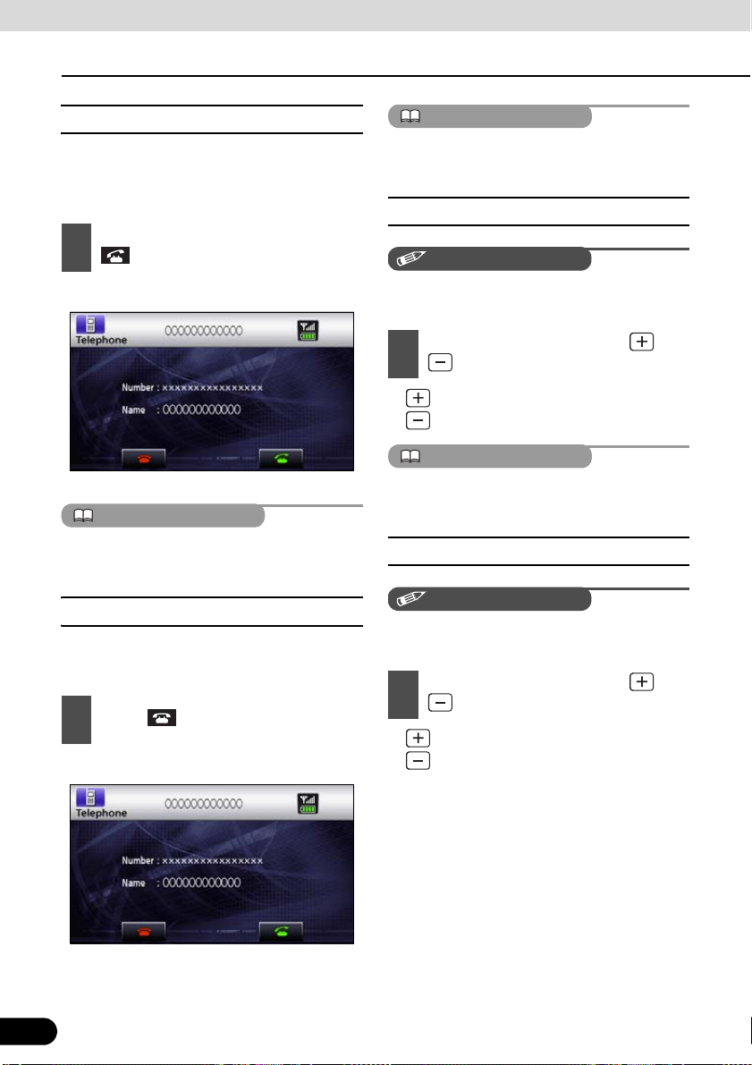
Before Use
ATTENTION
ATTENTION
CHECK
ATTENTION
CHECK
Bluetooth Hands-Free Operation
■ Receiving a call
You can receive incoming calls in any source
mode. When a call arrives, the Calling screen
is displayed automatically.
When you hear the ringtone, touch
1
.
Refused calls are stored in the incoming call
history.
■ Adjusting the ringtone volume
● You are connected and able to talk. .
● Calling screen
You can also receive calls automatically. See
“Auto Answer settings” on page 45
■ Ending a call (call refusal)
You can end a telephone conversation and
refuse calls.
Touch on the Calling screen.
1
● The call will end.
Make adjustments to the ringtone during
ringing.
Adjust the volume by pressing and
1
● : Increase ringtone volume
Sound is not emitted unless the ringtone is set
to ON.
.
: Decrease ringtone volume
■ Adjusting the talking volume.
Make adjustments to the talking volume when
talking.
Adjust the volume by pressing and
1
● : Increase talking volume
.
: Decrease talking volume
● Calling screen
44
44
Page 47

■ Hands-free settings
Change Code
Off
Off
Off
Change Code
Clear
Done
You can perform settings for hands-free
operation on the Phone setting screen.
Setting
Touch on the Hands-free
1
screen.
Auto Answer settings
Start talking five seconds after arrival of
incoming call.
On
Touch or .
1
Ringtone settings
For setting to emit the cell-phone ringtones.
On
Touch or .
1
Auto Connect settings
On the Phone setting screen, you can
2
perform the following settings using
the settings switches.
Phone setting screen
Item Function
Auto Answer For setting automatic call
Ringtone For setting ringtone
Auto Connect For setting automatic connection
Change Code
acceptance
between registered cell phone
and this receiver.
Touch to
change the PIN CODE.
For setting automatic connection between
registered cell phone and this receiver.
On
Touch or .
1
PIN Code setting
For changing the PIN CODE.
Touch .
1
Enter over a 4–digit under a 8–digit
2
number.
● Each touch of deletes a single
character.
45
Touch .
3
45
Page 48

Starting Out
About GPS Navigation
Before Using the GPS Navigation
■ Simple mode and Advanced mode
The two operating modes of Navigation
mainly differ in the menu structure and the
number of available features. The controls
and screen layouts are the same.
● Simple mode: You have easy access to
the most important navigation functions
and the basic settings only. The rest of the
settings are set to values that are optimal
for typical use.
● Advanced mode: You have access to the
full functionality of Navigation.
Switching from Simple mode to Advanced
mode: From the start screen (Navigation
menu), touch [Settings], [Advanced Mode].
● Switching from advanced to Simple mode:
From the start screen (Navigation menu),
touch [Settings], [Simple Mode].
Viewing Navigation Screen
■ Screen switches and other operations
When using Navigation, you usually touch
the switches on the touch screen.
You only need to confirm selections or
changes in Navigation if the application
needs to restart. Otherwise, Navigation
saves your selections and applies the new
settings without confirmation as soon as you
use the controls.
46
46
Page 49

Type
Example
Touch
a Touch to
switch
Icon b Shows status
List c When you
Slider d When a feature
Check
e When there
switch
Description How to use
initiate a
function, to
open a new
screen, or to
set a
parameter.
information.
need to select
from several
options, they
appear in a list.
has several
different
unnamed
values,
Navigation
shows an
indicator on a
gauge for
displaying and
setting a value
from a range.
are only two
options, a
checkmark
shows whether
the feature is
enabled.
Only one touch
is required.
Some icons
also function
as switches.
Only one touch
is required.
Move between
pages by
touching the
switches of c.
● Drag the
handle to
move the
slider to its
new
position.
● Touch
position of
handle on
slider. Move
your finger.
Touch to turn
the switch on
or off.
Type
Example
Virtual
f Alphabetic and
keyboard
Description How to use
alphanumeric
keyboards to
enter text and
numbers.
Each key is a
touch screen
switch.
47
47
Page 50

Operation
Navigation Overview
Navigation Menu
This is the Navigation menu. From here, you can access the following screens. Touch the
following switch on map screen: [Menu]
Screen Touch switch Description
Map [Map] The Map screen.
Find [Find] Select destination (for example an address or a POI) or use the search
Route [Route] Manage an active route (obtain information relating to route, modify or
Manage [Manage] Manage user data such as saved locations (POI, Favorites, Pins, and
Settings [Settings] Manage the behavior of Navigation, including the map layout during
engine of Navigation for any other reason (for example to look for the
phone number of a POI).
delete route or part of route.) Also, plan route without GPS reception.
History), saved routes, and Track Logs.
navigation, language and warnings.
Navigation Details Setting Screen
■ Settings menu
You can configure the program settings, and modify the behavior of Navigation. Touch the
following switches: [Menu], [Settings]
The Settings menu has two pages of submenus. Touch to access the other options.
48
48
Page 51

Touch switch Description Reference
[Map Screen] You can fine-tune the appearance and content of the
Map screen.
[Route Planning] These settings determine how routes will be
calculated.
[Navigation] You can control how Navigation behaves during
navigation.
[Sound] You can adjust the voices of Navigation. 61
[Regional] These settings allow you to customize the application
for your local language, measurement units, time and
date settings and formats, as well as to choose the
voice guidance profile you prefer.
[Warnings] You can enable some useful warnings, and disable
the touch screen in a moving vehicle with Safety
Mode.
[Menu] You can modify the look and behavior of the Menu
screens.
[Track Logs] You can set up automatic Track Log saving and fine-
tune related settings.
[Traffic INFO] You can check connecting information of TMC. You
can receive SUNA Traffic service.
[About] This screen has no navigation feature. It merely
provides information about the maps and licenses
included with your navigation system.
[Simple Mode] You can switch to Simple Mode. In Simple Mode only
a few of the above settings are available. The
remaining settings are set to the optimal values for
typical use.
52
53
55
55
56
57
57
58
None
46
49
49
Page 52

Operation
Navigation Overview
■ Quick Menu
The Quick menu is a selection of controls that are frequently needed during navigation. It is
opened from the Map screen. Touch the following switches on the map:
Touch the switch in the Quick menu to start the Map screen immediately. Switches are on
when lit up.
Name Main function (single touch) Function (touch and hold)
3D buildings can be displayed on the
map. Use this switch to suppress them
temporarily.
Turn Track Logs on and off. This
function can also be controlled from
the Manage Track Logs screen.
[GPS] Opens the GPS Data screen, which
includes satellite information, data
coming from the GPS receiver, and a
shortcut to the GPS Setting screen if
needed.
[TMC] This switch opens the list of Traffic
messages.
Opens 3D settings.
Opens Manage Track Logs screen.
No action
No action
50
50
Page 53

■ Route menu
Save, load and edit your routes. Touch the following switches: [Menu], [Route]
Touch switch Description Reference
[Route Info] Opens a screen with useful route data. 85
[Itinerary] You can browse the driving instructions that
Navigation follows during navigation. You can
exclude maneuvers or streets to adjust the route to
your preferences.
[Edit Route] Modify routes: Delete route points or modify their
order.
[Load Route] You can load a previously saved route for navigation. 78
[Save Route] You can save the active route for later use. 77
[Delete Route] You can delete the active route and all the route
points (start point, via points, and destination). If you
later decide that you need the same route, you will
have to rebuild it from scratch.
[Settings] Opens the Route settings screen with controls to
modify the road types used for route calculation and
the route calculation method.
[Fly Over] You can run a demonstration of the route at high
speed.
[Simulate] You can run a demonstration of the route at normal
speed.
■ Management menu
84
85
102
53
104
104
You can manage the content that this unit stores. Touch the following switches: [Menu],
[Manage]
Touch switch Description Reference
[Save Routes] Renaming or deleting saved routes 103
[Track Logs] Recording, simulating, renaming or deleting Track
Logs, assigning them a color to be shown on the map
[POI] Creating, updating or deleting POIs
Creating, updating or deleting POI groups
Modifying POI visibility setting
[History] Deleting histories 102
[Favourites] Renaming or deleting Favorites 105
[Saved Search Criteria] Creating, renaming or deleting saved search criteria 87
[User Data Management] You can manage the data you have saved and the
settings you have made in the program.
103
82
52
51
51
Page 54

Operation
Navigation Overview
■ User data management
You can manage settings implemented for saved data (Pins, POI, Favorites, History, and Track
Logs) and programs. Touch the following switches :[Menu], [Manage], [User Data
Management]
Touch switch Description
[Remove Pins] You can add Pins to locations on the map using the [Place Pin] switch
[Back Up User Data] All user data and the current settings will be saved on the inserted
[Restore User Data] All user data and settings will be overwritten with the information stored
[Delete User Data] All user data will be deleted, and settings will return to their factory
[Reset All Settings] All settings will return to their factory defaults, but no user data will be
■ Map screen settings
from the Cursor menu(See page 63). Touch this switch to remove all
Pins from the map.
memory card. There is always one backup file. If you perform a backup
later, the previous backup will be overwritten with the new information.
in the backup file. Data and settings created after the latest backup will
be lost.
defaults. This unit will restart.
deleted. This unit will restart.
You can fine-tune the appearance and content of the Map screen. Touch the following
switches: [Menu], [Settings], [Map Screen]
Touch switch Description
[3D Settings] Use 3D settings to determine which of the present 3D objects are
[Colour Profiles] Navigation is able to show the map and the menus in different colors
[Elevation on 2D Map] You can display 3D information on 2D map. These top-down maps can
52
52
shown on the map, and adjust the level of 3D visual detail.
The options are as follows:
● Landmarks: Landmarks are 3D artistic or block representations of
prominent or well-known objects. 3D landmarks are only available in
selected cities and countries.
● Elevated roads: Complex intersections and vertically isolated roads
(such as overpasses or underground tunnels) are displayed in 3D.
● Building visibility: Full 3D city building data that represents actual
building size and position on the map. Building data is limited to the
city centers of major cities in Australia.
● Terrain detail: 3D terrain map data shows changes in terrain,
elevations or depressions in the land when you view the map. Use it
to plot the route map in 3D when you navigate.
during the day and night. Select the color profiles to be used in each
mode, and the daytime and night color profiles interlock lighting and
lighting out of vehicle.
display elevation by colors and shading.
Page 55

Touch switch Description
[Street Names During
Navigation]
[Lane Information] Some maps contain lane information to help you position your car in
Street names and POI icons can get in the way on the map during
navigation. With this switch you can suppress these map elements
when Navigation is following your position on the map.
If you move the map, both the street names and POI icons reappear
immediately.
the upcoming intersection. This setting tells Navigation whether to
display this information at the top or at the bottom of the map. You can
prevent the display of lane information.
■ Route planning option
These settings determine how routes will be calculated. Touch the following switches: [Menu],
[Settings], [Route Planning]
Touch switch Description
[Road Types Used for Route
Planning]
[Route Calculation Method] You can choose from different route types. The routing method can be
[Use Traffic Information] When traffic messages are received, this setting tells Navigation
[Recalculate To Avoid Traffic] This setting determines how Navigation uses the received Traffic
To make the route fit your needs, you can also set which road types
are, where possible, to be considered for and excluded from the route.
Excluding a road type is a preference. It does not necessarily mean
total prohibition. If your destination can only be accessed using some
of the excluded road types, they will be used but only as much as
necessary. In this case a warning icon will be shown on the Route
Information screen, and the part of the route not matching your
preference will be displayed in a different color on the map.
changed temporarily while creating the route: When selecting the
destination, touch [Routing Methods] in the Cursor menu.
Touch [Routing Methods].
whether to use that information in route planning.
information in route recalculation:
● Automatic: When route recalculation becomes necessary based on
the received Traffic events, Navigation recalculates the route
automatically.
● Manual: When route recalculation becomes necessary based on
the received Traffic events, Navigation notifies you, but you can
decide whether to recalculate the route or not.
● Disabled: Traffic events are only taken account when the route is
recalculated in an off-route situation.
53
53
Page 56

Operation
Navigation Overview
Road Types Used for Route Planning:
Type Description
[Unpaved Roads] Navigation excludes unpaved roads by default: Unpaved roads can be
[Motorways] You might need to avoid motorways when you are driving a slow car or
[Ferries] Navigation includes ferries in a planned route by default. However, the
[Cross-border Planning] In some cases the route calculated according to your other navigation
[Permit Needed] You might need a permit or permission from the owners to use certain
[Pre-use Toll] By default Navigation includes toll roads (pay roads where there is a
[Period Charge] Charge roads are pay roads where you can purchase a pass or
in a bad condition and usually you cannot reach the speed limit on
them.
you are towing another vehicle.
map does not necessarily contain information about the accessibility of
temporary ferries.
You might also need to pay a fare on ferries.
and route preferences will lead through another country. If you wish to
always stay within the same country, turn this option off.
roads or to enter certain areas. Navigation excludes these roads from
the route calculation by default.
per-use charge) in the routes. If you disable toll roads, Navigation plans
the best toll-free route.
vignette to use the road for a longer period of time. They can be
enabled or disabled separately from toll roads.
Route calculation methods:
Option Description
Fast Gives the quickest possible route if you can travel at or near the speed
Easy Results in a route with fewer turns. With this option, you can make
Economical Look for trade off of speed and shortness with cost. Navigation
Short Gives a route that has the smallest total distance of all possible routes
54
54
limit on all roads. Usually the best selection for fast and normal cars.
Navigation take, for example, the freeway instead of series of smaller
roads or streets.
calculates as if it were calculating the Fast route, but it takes other
roads as well to save on fuel costs.
between the route points.
Page 57

■ Navigation settings
You can control how Navigation behaves during navigation. Touch the following switches:
[Menu], [Settings], [Navigation]
Touch switch Description
[Keep Position on Road] This feature allows car drivers to always correct GPS position errors by
[Off-route Recalculation] This switch tells Navigation whether to automatically recalculate the
[Restore Lock-to-Position] If you have moved or rotated the map during navigation, this feature
[Automatic Overview] This feature switches the map view to Overview mode when the next
matching the vehicle position to the road network.
By turning off this feature, you also turn off the GPS position error
filtering. The position shown on the map will be subject to all position
errors and position fluctuations.
route when you deviate from it. When this feature is switched off, it is
necessary to start route recalculation manually. Otherwise, navigation
will stop until you return to the recommended route.
Setting a point other than the current GPS position as the start point of
the active route will automatically disable this feature.
moves the map back to your current GPS position and re-enables
automatic map rotation after the given period of inactivity.
route event is far away. Overview is a zoomed out 2D view to let you
see the surrounding area. You have the following controls for
Automatic Overview:
● Turn Distance for Overview: The map view will be switched to
Overview mode if the next route event is at least as far as this value.
● Default Zoom Level: Overview mode will appear with this zoom
level. You can scale the map in Overview mode but when Overview
appears again, this zoom level will be applied.
■ Regional settings
These settings allow you to customize the application for your local language, measurement
units, time and date settings and formats, as well as to choose the voice guidance profile you
prefer. Touch the following switches: [Menu], [Settings], [Regional]
Touch switch Description
[Program Language] This switch displays the current written language of the Navigation user
interface. By touching the switch, you can select a new language from
the list of available languages. Changing this setting causes the
application to restart. Be aware of this before you make the change.
[Voice Profile] This switch displays the current voice guidance profile. By touching the
switch, you can select a new profile from the list of available languages
and speakers. Touch any of these to hear a sample voice prompt. Just
touch OK when you have selected the new spoken language.
55
55
Page 58

Operation
Navigation Overview
Touch switch Description
[Units] You can set the distance units to be used by the program. Navigation
[Set Date & Time Format] You can set the data and time format. A variety of international formats
[Time and Time Zone Settings] You can access time and time zone settings. Navigation helps you with
Time and Time Zone Settings
Touch switch Description
[Auto Time Correction to GPS] Use this feature to synchronize the clock of your device to the highly
[Use Auto Time Zone] Use this feature to synchronize the time zone of the clock of your
[Set Time Zone] Set time zone manually if you do not want to synchronize the time zone
The clock function of this unit interlocks GPS signal.
The clock may be out of order when not receiving GPS signal.
may not support all the listed units in some voice guidance languages.
If you select a measurement unit not supported by the chosen voice
guidance language, a warning message will appear.
are available.
correcting the device time to ever accurate GPS time. Navigation can
also help you set the time zone based on your current GPS position.
accurate time provided by the GPS receiver.
device to the time zone based on your current GPS position. This is
useful if you travel abroad.
automatically. This allows you to use Auto Time Correction and apply a
time zone offset to obtain the desired time.
■ Warning settings
You can enable some useful warnings, and disable the touch screen in a moving vehicle with
Safety Mode. Touch the following switches: [Menu], [Settings], [Warnings]
Touch switch Description
[Warn When Speeding] Maps may contain information about the speed limits of the road
56
56
segments. Navigation is able to warn you if you exceed the current
limit. This information may not be available in your district (ask your
local dealer). Also, this information may not be completely accurate for
all roads on the map. This setting lets you decide whether you wish to
receive the warnings. You can set the relative speeding level at which
the application warns you (100% represents the current speed limit):
● In built-up areas
● Elsewhere: at all other locations
There are two types of warnings. You can turn them on or off
independently:
● Audible warning: A voice message is played using the selected
voice guidance profile.
● Visible warning: A symbol with the speed limit appears in the corner
of the map (for example: )
Page 59

Touch switch Description
[Speed Camera Warning] This feature allows you to receive a warning when approaching a Road
[Safety Mode] Safety Mode disables the touch screen above 10 km/h (6 mph) to keep
Safety Camera. You must ensure on your own liability that using this
feature is legal in the country where you intend to use it.
The options are as follows:
● Audible Warning: Plays back buzzer sound as you approach a
camera. You can also limit the warning to playing when you are over
the speed limit on approach.
● Visual warning: The type of the camera and the monitored speed
limit appear on the Map screen as you approach.
your attention on the road. While driving, you will not be able to set a
new destination or change settings. The only screen control that
remains enabled is the gesture that puts you back on the Map screen.
■ Menu settings
You can modify the look and behavior of the Menu screens. Touch the following switches:
[Menu], [Settings], [Menu]
Touch switch Description
[Animation] You can activate and deactivate the Menu animations. When
[Background] You can choose the image to be used as the menu background image.
animation is turned on, switches on Menu and keyboard screens are
animated.
■ Track log settings
You can set up automatic Track Log saving and fine-tune related settings. Touch the following
switches: [Menu], [Settings], [Track Logs]
Touch switch Description
[Update Interval] This determines how often track points will be saved. Position
information is normally received once a second from the GPS. If you do
not need such a detailed log, you can increase this number to save
Track Log space.
[Enable Auto-saving] When auto-saving is enabled, you do not need to turn Track Log saving
on and off manually. Navigation will automatically start recording the
Track Log as soon as GPS position is available.
[Track Log Database Size] This figure shows how much memory is used by the automatically
saved Track Logs.
[Track Log Max. Size] You can set the maximum database size for the automatically saved
Track Logs. When the limit is reached, the oldest automatically saved
Track Logs will be deleted.
[Create NMEA/SIRF Log] Independently of the normal Track Log, you can instruct Navigation to
record the native GPS data received from the GPS device. This
information is saved as a separate text file on the memory card and
cannot be played back by Navigation.
57
57
Page 60
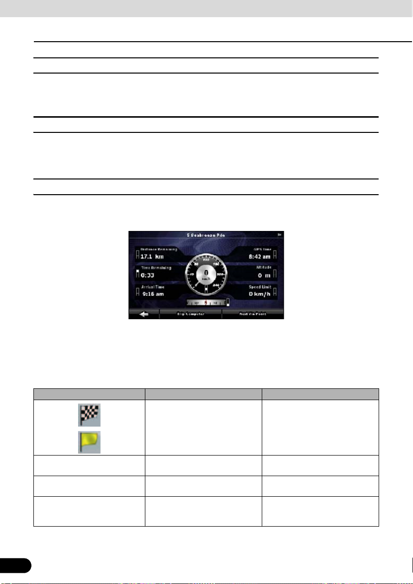
Operation
Navigation Overview
■ TMC settings
You can check connecting information of TMC (SUNA Traffic service). Touch the following
switches: [Menu], [Settings], [Traffic INFO]
■ Safety Mode settings
This feature is available in Advanced mode only.
Touch the following switches: [Menu], [Settings], [Warnings], [Safety Mode]
■ Trip information screen
The Trip information screen has both route and travel data you might need during your journey.
It can be opened directly from the Map screen by touching the Trip Data field.
The fields on this screen are continuously updated while the screen is open.
When you open the screen, all route data fields contain information about reaching your final
destination. Touch [Next Via Point] to have the fields relating to your route display data for the
next via point. Touch the switch repeatedly to toggle between the two options.
You have the following data and functions on this screen:
Name Description Function
Shows whether the route data
fields are displaying information
about the final destination
(checkered flag) or about the next
via point (yellow flag).
Field next to the flag Shows the name or number of the
Turn Preview Shows the type and distance of
Compass Shows the current heading. Touch this field to show it on the
58
58
current street or road.
the next route event.
None
None
None
Map screen in one of the Trip Data
fields.
Page 61

Name Description Function
Speedometer Shows the current speed both
graphically and as a number.
Distance Remaining Shows distance remaining to final
destination.
Time Remaining Shows the time needed to reach
the final destination of the route
based on information available for
the remaining segments of the
route. The calculation cannot take
into account traffic jams and other
possible delays.
Arrival Time Shows the estimated arrival time
at the final destination of the route
based on information available for
the remaining segments of the
route. The calculation cannot take
into account traffic jams and other
possible delays.
GPS Time Shows the current time corrected
with time zone offset. The
accurate time comes from the
GPS satellites, and the time zone
information either comes from the
map or is set manually in Regional
settings.
Altitude Shows elevation if it is provided by
the GPS receiver.
Speed Limit Shows the speed limit of the
current road if the map contains it.
Trip Computer Opens a new screen with three
Next Via Point Touch this switch to change the
[Destination] Touch this switch to have the
Touch this field to show it on the
Map screen in one of the Trip Data
fields.
Touch this field to show it on the
Map screen in one of the Trip Data
fields.
Touch this field to show it on the
Map screen in one of the Trip Data
fields.
Touch this field to show it on the
Map screen in one of the Trip Data
fields.
Touch this field to show it on the
Map screen in one of the Trip Data
fields.
Touch this field to show it on the
Map screen in one of the Trip Data
fields.
Touch this field to show it on the
Map screen in one of the Trip Data
fields.
resettable Trip Computers.
content of the Route Data fields to
show information about the next
via point.
If you touch the previous switch,
this one replaces it.
Route Data fields show
information about the final
destination again.
Most of the fields on this screen have a symbol next to them. This symbol shows whether the
field it is attached to is shown on the map as Trip Data. It also shows the position of the data as
follows:
59
59
Page 62
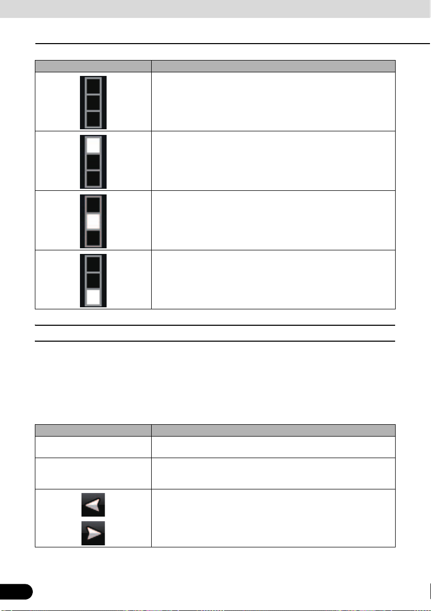
Operation
Navigation Overview
Symbol Description
This value is not shown on the Map screen.
This value appears on the Map screen in the Trip Data area. This is the
value at the top.
This value appears on the Map screen in the Trip Data area. This is the
value in the middle.
This value appears on the Map screen in the Trip Data area. This is the
value at the bottom.
■ Trip computer screen
The Trip computer screen provides collected trip data. Touch [Trip Computer] on the Trip
information screen to open the Trip computer screen.
The fields on this screen are continuously updated while the screen is open.
You can switch between trips, pause and resume a trip, or reset.
You have the following functions on this screen:
Name Description
[Pause] Pauses the trip currently shown on the screen. Values on the screen
[Reset] Resets all counters of the currently shown trip. The collection of trip
60
60
stop changing.
data is restarted only when Navigation receives a position from the
GPS.
Cycles through all trips.
Page 63

ATTENTION
If the vehicle's battery is disconnected (for repairs to the vehicle or for removing this unit), all the
Trip Computer history (Average Speed, Total time, etc) in the memory will be lost.
Screen Adjustment and Setting
■ Day screen and night screen
This unit uses different color profiles during the day and during the night.
● Daytime colors are similar to those of paper road maps.
● The night color profiles use dark colors for large objects to keep the average brightness of
the screen low.
This unit offers different daytime and night color profiles. You can switch the daytime and night
color profiles based on lighting and lighting out of vehicle.
■ Screen color in tunnels
When entering a tunnel, the colors of the map change. All buildings disappear, and large
objects (such as surface waters or forests) and empty areas between roads become black.
However, roads and streets keep their original colors from the daytime or night color scheme
currently in use.
After leaving the tunnel, the original colors return.
■ Volume settings
You can adjust the sounds of Navigation. Touch the following switches: [Menu], [Settings],
[Sound]
Touch switch Description
[Voice Guidance Volume] The slider adjusts the loudness of voice prompts. At the left-end, you
[Dynamic Volume] When driving at high speed, the noise in the car may be too loud to
[Dynamic Volume Settings] You can adjust a maximum and minimum speed of speed range to
61
cannot hear the voice guidance. At the right-end, the volume is high.
clearly hear the voice guidance and other sounds. Using Dynamic
Volume you can instruct Navigation to increase the volume when your
speed exceeds a given minimum, and reach its highest volume at the
given maximum speed.
volume up.
61
Page 64

Operation
Navigation Overview
Map Display
■ Present location display
Access from the Navigation menu by touching [MAP].
For further information about the Map screen, see “Map screen” on page 78.
Navigation displays the route as follows.
Symbol Name Description
Current GPS position Your present position displayed on the map.
62
Cursor (selected map position) The location selected in the Find menu, or a map
point selected by touching the map.
Start point The first point of the route.
Normally, if GPS position is available, it is used as the
start point of the route. If there is no valid GPS
position, Navigation uses the last known GPS
position as the start point.
When you are using a saved route, Navigation asks
you if you want to use your GPS position or the first
point in the saved route as the start point.
You can also modify the start point in the Cursor
menu. If you do so, automatic off-route recalculation
needs to be turned off to keep the selected point as
the start point.
If automatic off-route recalculation is disabled for any
of the above, touching the icon in the Turn
Preview field not only initiates route recalculation
from the current GPS position, but also re-enables
the automatic off-route recalculation.
Via point The via points are intermediate destinations. You can
place as many via points as you want.
Destination (end point) The last point of the route, the final destination.
62
Page 65

Symbol Name Description
Route color The route stands out against the map, both in daytime
Active leg of the route The section of the route on which you are driving. If
Inactive leg of the route Upcoming sections of the route. Each of these
Streets and roads that are
excluded from the navigation
and night color modes. The active leg of the route is
always displayed in a brighter shade than the inactive
(upcoming) legs.
no via points have been added (destination only), the
entire route becomes the active leg. When via points
have been added, the active leg is the section of the
route from the present location to the next route point
(the next via point or the final destination if there are
no more via points).
becomes active when you arrive at the corresponding
via point.
You can select whether or not to use certain road
types. (See page 53) However, when Navigation
cannot avoid such roads, the route will include
them,showing them in a different color to the route.
■ Cursor menu
As soon as you select a location in the Find menu, the map appears with the Cursor menu
which provides possible actions for the selected point.
Alternatively, touch the map to make the control switches appear. Touch again to place the
Cursor, a radiating red dot. Now touch again to open the Cursor menu with a list of options.
Since the Cursor menu only displays a portion of the map, the menu initially includes only a few
switches. Touch [More Options] to open all options.
63
Touch switch Description
Closes the Cursor menu, and returns to the previous screen.
Zooms out the map.
Zooms in the map.
You can move the map and zoom in and out while the Cursor menu is
open. Touch anywhere on the map to place the Cursor in a new
location. Use this switch to return the Cursor to the position it occupied
at when the Cursor menu was opened.
Displayed at the Cursor when it is at the position it occupied when
Cursor menu was opened.
Displayed at the Cursor if it has been relocated since the Cursor menu
was opened.
63
Page 66

Operation
Navigation Overview
Touch switch Description
[Info] Opens a new screen showing the address of the Cursor and nearby
[More Options] Opens the full-screen Cursor menu with all the available options.
[Set as Destination] Creates a new route with the Cursor as the destination. The previous
[Remove Destination] When the cursor is at the destination or nearby, this switch replaces the
[Insert as Via] The Cursor is added to the active route as an intermediate route point,
[Remove Via] When the cursor is at or near one of the via points, this switch replaces
[Continue] Adds Cursor to the end of the route as new destination. The previous
[Routing Methods] This switch resembles [Set as Destination]. Here, however, a new
[Set as Start] The Cursor becomes the start point of the route. This means that the
[Remove Start] When the cursor is at the start point or nearby, this switch replaces the
[Save as POI] The Cursor is saved as a user POI. Select the POI group, name the
[Place Pin] Map locations can be marked with Pins. Unlike POIs, Pins have no
[Remove Pin] When the cursor is at or near a pin, this switch replaces the previous
[Add to Favorites] Adds Cursor location to list of frequently visited destinations, or
[Save as Camera] The Cursor is saved as the location of a Road Safety Camera (speed
[Edit Camera] If the Cursor is at or near a Road Safety Camera, this switch replaces
POIs.
route (if one exists) is deleted.
previous switch, and the present location disappears from the route.
The last via point is promoted as destination, or if there are no via
points, the route is deleted.
a point to be reached before the destination. If the route already
includes via points, the Edit route screen will open. This screen shows
where on the route the via point will be displayed.
the previous switch, and the selected via point disappears from the
route. The route is recalculated without the deleted point.
destination is demoted, and becomes the last via point.
screen opens, and routes are calculated using all available calculation
methods (fast, short, economical, easy). Observe the results, and
choose one of the routes to navigate.
route is not started from the current GPS position, and Automatic Offroute Recalculation needs to be turned off to keep the selected point as
the start point.
previous switch and the start point disappears from the route. The
current GPS position is again used as the start point, and Automatic
Off-route Recalculation is re-enabled.
POI, select a suitable icon, and enter a phone number and additional
information as appropriate.
names and other details, only colors to let you tell them apart on the
map.
switch, and you can delete the pin.
Favorites. You can name the Favorite.
camera or red light camera). A new screen appears where you can set
the type of the camera, the direction of the measured traffic, and the
speed limit checked.
the previous one, and opens a new screen where you can edit the
details of the camera.
64
64
Page 67

■ Position menu
When you follow the recommended route on the map (the Cursor is the current GPS position),
the Position menu replaces the Cursor menu. It does not contain switches that modify the
current route, as the GPS position is not useful as a route point.
To open Position, touch [Position].
■ Checking vicinity information
● If you are interested in the details of your present position during navigation:
Check the bottom line of the map. It shows the current street and house number
1
information.
For details, touch [Position] to open the Position menu.
2
Touch [Info]. The address, coordinates and a list of nearby POIs are displayed.
3
● You can check the details of any other location by selecting it on the map:
Touch the map anywhere to open the map control switch.
1
Touch the desired location on the map. The Cursor ( ) appears there. The address of
2
the location is displayed at the bottom of the map.
For further details, touch [Cursor] to open the Cursor menu.
3
Touch [Info]. The address, coordinates and a list of nearby POIs are displayed.
4
● It is even easier if you select the desired point in the Find menu. Then the Cursor menu
opens automatically. Just touch [Info].
65
65
Page 68

Operation
Navigation Overview
■ Map menu operations
Position marks on map
● Current GPS position: (See page 62)
● Selected location (Cursor): (See page 63)
The following controls help you modify the map view to best suit your actual needs. Most of
these controls appear with a single touch of the map, and disappear after a few seconds of
inactivity.
Action Touch switch Description
Moving the map with drag&drop None You can move the map in any direction:
Opening/closing map control
switches
Zooming in and out Changes how much of the map is displayed
Tilting up and down Changes the vertical view angle of the map
Touch and hold the map, and move your
finger in the direction in which you want to
move the map.
If GPS position is available and you have
moved the map, switch appears. Touch
this switch to return to the GPS position.
Touch this switch to show or hide the
following map control switches:
● Zoom in/out
● Rotate left/right (3D map only)
● Tilt up/down (3D map only)
● Zoom preset switches (2D map only)
● Tilt and zoom preset switches (3D map
only)
● Return to GPS position switch
● Smart Zoom
on the screen.
Navigation uses high-quality vector maps
that let you see the map at various zoom
levels, always with optimized content. Street
names and other text is always are always
shown in the same font size and correctly
orientated. You can restrict the view to
required streets and objects.
The limits on zooming differ for the 2D and
3D map viewing modes.
in 3D mode.
66
66
Page 69

Action Touch switch Description
Rotating left and right Changes the horizontal view angle of the
Viewing modes The following map perspectives are provided
Smart Zoom Navigation can automatically rotate, scale
Return to normal navigation
(Return to GPS position with
automatic map rotation)
map in 3D mode.
When GPS position is available, Navigation
always rotates the map so its top faces your
direction of travel (Track-Up orientation).
You can turn away from Track-Up with these
switches.
If GPS position is available and you have
rotated the map, the switch appears.
Touch this switch to re-enable the automatic
map rotation.
in Navigation:
● Perspective view (3D)
● Classic top-down view (2D)
● North up
The icon always shows the mode the switch
switches to:
In 3D mode, is displayed. Touch to
switch to 2D mode. In 2D mode, is
displayed. Touch to switch to North up mode.
In North up mode, is displayed. Touch to
switch to 3D mode.
and tilt the map and give you the optimal
view:
● When you approach a junction, it will
zoom in and raise the view angle to let
you easily recognize your maneuver.
● If the next junction is at a distance,
Navigation zooms out and lowers the
view angle to show you the road in front of
you.
Touch this switch once to enable Smart
Zoom.
Touch and hold this switch once to set the
zoom limit on Smart Zoom.
Touch this switch to move the map back to
the current GPS position. If the map has
been rotated in the 3D mode, automatic map
rotation is also re-enabled.
67
67
Page 70

Operation
Navigation Overview
Action Touch switch Description
Zoom preset
(Advanced mode only)
Tilt and Zoom preset
(Advanced mode only)
Map scale Navigation shows the scale of the map in 2D
Fit to screen [Fit to screen] This switch is not shown on the Map screen.
Touch the preset switch once to set the
zoom level to a fixed predetermined value.
Smart Zoom is disabled. These switches are
available in 2D mode.
Touch and hold the desired switch to set the
zoom value as the current zoom level, or
reset to an original value.
Touch the preset switch once to set the
zoom level to a fixed predetermined value.
Smart Zoom is disabled. These switches are
available in 3D mode.
Touch and hold the desired switch to set the
zoom value as the current zoom level, or
reset to an original value.
mode.
It is available on the following screens:
● Plan on map screen: When you have an
active route, you can display it in its full
length on the map.
● Track information screen: A Track Log
can be displayed in its full length on the
map.
■ Map screen status information and hiding operation
The following information appears in the rounded field in the top left corner, the Turn Preview
field. When you touch this area, the result depends on what information is currently shown.
Icon Information Details Action
68
There is no active
route in Simple mode.
There is no active
route in Advanced
mode.
There is no valid GPS
position.
68
When there is no active route in
Simple mode, this icon is
displayed in the Turn Preview
field.
If there is no route to be
navigated in Advanced mode,
this icon appears in the Turn
Preview field.
If an active route exists, and
there is no valid GPS position,
the view of the sky above you is
shown with colored dots for each
satellite. Some dots need to turn
green to allow navigation.
Touch this area to open
Find Address.
Touch this area to open
Find.
Touch this area to open the
Route information screen.
Page 71

Icon Information Details Action
If the icon is a static
picture, route
calculation is needed.
This icon indicates that
route calculation is in
progress.
Next route event
(Next action)
GPS position and an active
route are available, but
automatic off-route recalculation
is switched off, and you deviated
from the route.
Navigation is calculating or
recalculating the route.
GPS position and an active
route are available, and you are
navigating the recommended
route. This area gives you
information about the type and
distance of the next route event.
Touch this area to make
Navigation recalculate the
recommended route.
Nothing happens if you
touch this area of the
screen.
Touch this area to open the
Route information screen.
The following area appears next to the above described rounded area. When you touch this
area, the result depends on what information is currently shown.
Icon Information Details Action
There is no valid GPS
position.
Traffic restriction When GPS position is available
Second route event
(maneuver after next
maneuver)
Approaching a Road
Safety Camera
Stops the running
simulation
Recalculating route During route recalculation, this
If there is no valid GPS position,
this symbol appears here.
but there is no route to be
navigated, any traffic restrictions
at upcoming intersections are
shown here.
When GPS position and an
active route are both available,
this field shows the route event
that follows the next route event
shown in the above described
area.
This icon appears when you are
approaching a Road Safety
Camera, and the warning for
cameras is enabled in Settings.
This icon is displayed during fly
overs, route simulation and
Track Log playback.
field shows the recalculation
progress between 0% and
100%.
Touch this area to open the
GPS Data screen to check
the signal status or the
connection settings.
Nothing happens if you
touch this area of the
screen.
Touch this area to open the
Itinerary screen with the turn
by turn guidance
instructions.
Touch this area to suppress
the audible camera warning.
Touch this area to stop the
simulation.
Nothing happens if you
touch this area of the
screen.
69
69
Page 72

Operation
Navigation Overview
Icon Information Details Action
Indicator strip
● Track Log recording
● TMC status
The following symbols appear in the Indicator strip:
Navigation records a Track log when GPS position is available.
Track log recording is disabled.
TMC is turned off.
A TMC Traffic data is received.
There are new, unread Traffic events.
A part of the route is bypassed based on Traffic events.
Nothing happens if you
touch this area of the
screen.
A part of the route is mentioned in Traffic events but it has not been
bypassed (for example, even the best detour would be too long) or
could not be bypassed (for example, the destination is on a congested
street).
There are two fields reserved on the Map screen to display the next two maneuvers (route
events that are listed in the Itinerary). Both the type of the event (turn, traffic circle, exiting
freeway, etc.) and its distance from the current GPS position are displayed.
Most of these icons are very intuitive and known as road signs. The following table lists some
of the frequently shown route events. The same symbols are used in both fields:
Icon Description
Turn left.
Turn right.
Turn back.
Bear right.
70
,
,
,
,
70
Page 73

Icon Description
,
Turn sharp left.
,
,
,
,
,
,
,
,
,
Keep left.
Continue straight in the intersection.
Enter traffic circle. The number of the exit is shown in the circle, but
only for the next turn.
Enter freeway.
Exit freeway.
Board ferry.
Leave ferry.
Approaching the next via point.
Approaching the destination.
The following information is displayed in three fields displayed on the Map screen. Touch this
area to open the Trip Information screen, and select from values displayed in the three fields.
When there is no active route, these fields show the following information. : Current speed,
compass and current time.
71
Icon Type More information
Compass Shows the direction of your heading both
when the map is automatically rotated (3D)
and when the map is always facing North
(2D).
Speed information There are speed values that can be shown.
● Current speed
● Speed limit on the current road
Time information There are time values that can be shown.
● Current GPS time
● Time remaining to the destination
● Time remaining to the next via point
● Estimated arrival time at the destination
● Estimated arrival time at the next via point
71
Page 74

Operation
ATTENTION
Navigation Overview
Icon Type More information
Distance information There are distance type values that can be
GPS reception quality shows the current accuracy of the position information.
Icon Description
GPS receiver not connected. GPS navigation is not possible.
Navigation is connected to the GPS receiver, but the signal is too weak
and the receiver cannot determine the GPS position. GPS navigation is
not possible.
GPS navigation is not possible.
Only a few satellites are received. Position information is available, but
elevation (altitude) cannot be calculated. GPS navigation is possible,
but the position error may be significant.
Altitude information is available, the position is a 3D position.
GPS navigation is possible.
shown.
● Distance remaining to destination
● Distance remaining to next via point
● Current altitude
Touch the following status field to open the Quick menu (See page 50).
Icon Status More information
GPS position quality A higher number of lit bars indicates better
GPS position accuracy.
■ Using the Cursor (at selected position)
First, place the Cursor at the desired map location with one of the following options:
● Use the Find menu to select a location. The map returns with the selected point (the Cursor)
in the middle, and the Cursor menu appears with the available options.
● Touch the screen twice to place the Cursor at the desired location. Touch the cursor to open
the [Cursor] menu.
The following actions are available.
Touch switch Action
[Set as Destination] On an active route, use the Cursor as the destination by resetting the
[Insert as Via] On an active route, use cursor as via point (intermediate location)
72
72
previous destination.
before destination (only available in Advanced mode).
Page 75

CAUTION
Touch switch Action
[Place Pin] Marks the map with a Pin at the Cursor (available in Advanced mode
[Routing Methods] Shows the different routes calculated by the available routing methods.
[Set as Start] On an active route, use the Cursor as the start point by resetting the
[Continue] On an active route, use cursor as destination with previous destination
[Save as POI] Save Cursor as POI (only available in Advanced mode).
[Add to Favourites] Saves the Cursor as a Favorite location.
[Save as Camera] Save Cursor as Road Safety Camera location (only available in
[Info] Opens a screen with the name, address and coordinate information of
only).
Choose the one that best suits your needs (available in Advanced
mode only).
current GPS position (available in Advanced mode only).
as via point (only available in Advanced mode).
Advanced mode).
the Cursor, and a list of nearby POIs.
■ Present location and route tracking
When your GPS position is available, Navigation marks your present position with the icon
on the map.
To use the current GPS position, touch [Position]. The Position menu appears and you can
save the GPS position as one of the following:
● A Favorite
● A Road Safety Camera
● A POI
● A Map Marker Pin
■ Returning to normal Map screen
When GPS position is available, and you have moved the map (the icon may have moved
or be invisible), or you have rotated the map in 3D mode, appears. Touch this switch to
return the map to the GPS position and re-enable Track-up map orientation (automatic map
rotation).
Even if you move the map while you are driving, Navigation continues navigating if there is an
active route. it plays the voice instructions and displays the turn preview icons according to your
current GPS position.
73
73
Page 76

Operation
Navigation Overview
■ Position determination (Cursor)
If you select a location in the Find menu, or you touch the map when the map control switches
are visible, the Cursor appears at the selected point on the map. Navigation displays the
Cursor with a radiating red dot ( ) to make it visible at all zoom levels, even when it is in the
background of a 3D map view.
When the Cursor is set, touch [Cursor]. The Cursor menu appears and you can use the Cursor
as one of the following:
● Start point of a route
● A via point in a route
● The destination of a route
You can also search for POIs around the Cursor.
Or you can save the location of the Cursor as:
● A Favorite
● A Road Safety Camera
● A POI
● A Map Marker Pin
■ Displaying original position in cursor menu
When the Cursor menu is open, a special icon ( ) shows the Cursor position the menu was
opened.
You can move and zoom the map, and reposition the Cursor. The usual Cursor ( ) appears,
and the switches of the Cursor menu initiate actions for this new location.
To return to the original Cursor position, tap . The map jumps back to the position it held
when the Cursor menu was opened, and the icon reappears.
■ Switching to desired scale
Smart Zoom provides much more than just a usual automatic zoom feature.
● While following a route calculated by Navigation:When you approach a junction, it will
zoom in and raise the view angle to let you easily recognize your maneuver. If the next turn
is at a distance, it will zoom out and lower the view angle to be flat so you can see the road
in front of you.
● While driving without an active route: Smart Zoom will zoom in if you drive slowly and
zoom out when you drive at high speed.
74
74
Page 77
Enabling smart zoom
CHECK
Touch the map to make the map control switches appear, and then touch to enable Smart
Zoom.
Fine-tuning Smart Zoom
Touch the map to make the map control switches appear, and then touch and hold to open
the Smart Zoom settings window. Modify the zoom limits of Smart Zoom as necessary.
■ Driving track display
This unit can log the track that you drive. (See page 103)
A Track Log is a record of the change in GPS position and is independent of the route
calculated by this unit.
Track Logs can be recorded, renamed, swapped, shown on the map, exported to a memory
card in GPX format, and deleted. (See page 103)
You can instruct this unit to record native GPS data received from the GPS device,
independently of the normal Track Log. These logs are saved as separate text files on a
memory card, and they cannot be shown or replayed in this unit.
To turn on NMEA/SIRF log saving, touch the following switches: [Menu], [Settings], [Track
Logs], [Create NMEA/SIRF Log].
■ Using logs
This unit can record the track (change in GPS position) as you drive.
There is no need to select a destination and create a route. Your path is recorded as you travel.
This feature is available in Advanced mode only.
The procedure is explained starting from the Map screen.
75
75
Page 78

Operation
Navigation Overview
Recording the travelled path (creating a Track Log)
Start driving.
1
Touch the following switches: [Menu], [Settings], [Track Logs]
2
Start recording: Touch [Record].
3
● You can return to the map and continue driving.
Repeat the above steps, then touch [Stop Recording] to stop the recording.
4
● Navigation labels the Track Log with a time stamp.
(As an alternative, you can touch in the Quick menu to start, and then again to stop the
Track Log recording.)
Simulating a Track Log on the map
76
Touch the following switches: [Menu], [Settings], [Track Logs]
1
Locate the desired Track Log, and then touch next to it.
2
The map returns, and the Track Log simulation (a life-like replay) begins.
3
You can stop the replay any time by touching [Stop].
4
76
Page 79

Changing the color of a Track Log
Touch the following switches: [Menu], [Settings], [Track Logs]
1
Touch the desired Track Log and then touch one of the color switches.
2
■ Saving route
This feature is available in Advanced mode only.
The procedure is explained starting from the Map screen.
Touch the following switches: [Menu], [Route], [Save Route]
1
Enter a name for the saved route, and then touch [Done].
2
● When saving a route, Navigation saves not only points along the route, but the entire
itinerary.
● The saved route might have been influenced by Traffic information. When a route is used at
later date, it may seem to be the saved route. However, where necessary, current Traffic
information is used to recalculate the new route.
● If you updated your map since you first saved the route, Navigation recognizes the change,
and recalculates the driving instructions according to the latest available map information.
● During navigation, Navigation deletes via points that you already left behind together with
the road segments used to reach it. If you wish to save the route, you need to do so before
starting to navigate.
77
77
Page 80

Operation
Navigation Overview
■ Loading saved route
This feature is available in Advanced mode only.
The procedure is explained starting from the Map screen.
Touch the following switches: [Menu], [Route], [Load Route]
1
Touch the route you wish to navigate.
2
In the very likely case that the start position of the saved route is different from the
3
current GPS position, you need to confirm whether you want to stop navigating from the
current GPS position to use the start point of the loaded route.
● If you choose to keep the current GPS position as the start point, the route will be
recalculated starting from your present position.
The map appears, and you can start navigating.
4
■ Map screen
Navigation is primarily intended for land navigation. That is why maps in Navigation look similar
to paper road maps. However, Navigation provides much more than regular paper maps. You
can customize the look and the content of the map. The most important and most often used
screen of Navigation is the Map screen.
78
78
2
1
4
3
5
18
6
7
Page 81

12
13 17
16
21
19
15
9
11 8
7
14
79
10
79
Page 82

Operation
Navigation Overview
20
During navigation, the screen shows route information and trip data (left screens), but when
you tap the map, additional switches and controls appear for a few seconds (right screenshot).
Most parts of the screen behave as switches.
Symbol Name Action
1 Main information. Ex) Next route event. Opens the Route Information screen.
2 Second upcoming route event Opens the Itinerary.
3 Trip information screen Opens the Trip information screen.
4 GPS position quality Opens the Quick menu
5
Top row
6
Bottom row
7 Map view modes Switches between 2D, 3D and North up
8 Menu Opens the Navigation menu.
9 Detour Opens the Detour screen. There are two
10 Position menu (appears when navigating a
11 Cursor menu (appears when there is no
12 Opens/closes the map control switches
13 Rotate left, rotate right Rotates the 3D map left or right
Next street n/a
Current street and house numbers on left
and right
route)
GPS position or the Cursor is not at the
current GPS position)
(touch this switch to display/hide the
following map control switches).
Tilt up, tilt down Tilts the 3D map
Zoom in, zoom out Scales the map
n/a
mode.
ways to modify your route.
● The list of saved Search Criteria
● A switch to avoid parts of the route
Opens the Position menu.
Opens the Cursor menu
● Zoom in/out
● Rotate left/right (3D map only)
● Tilt up/down (3D map only)
● Zoom preset switches (2D map only)
● Tilt and zoom preset switches (3D map
only)
● Return to GPS position switch
● Smart Zoom
80
80
Page 83

Symbol Name Action
14 Return to GPS position (appears when
15 Enable Smart Zoom (replaces the Previous
16 Zoom preset switch (available in Advanced
17 Tilt preset switch (available in Advanced
18 Current GPS position (on nearest road) n/a
19 Cursor (selected map location) n/a
20 Lane information n/a
20
Orange line
21 Map scale (2D map only) n/a
GPS position is available and you have
moved the map)
switch when there is no GPS position or
the map has not been moved).
mode only).
mode only).
Active route n/a
Touch this switch to move the map back to
the current GPS position. If the map has
been rotated in 3D mode, automatic map
rotation is also re-enabled.
Touch this switch once to enable Smart
Zoom.
Touch and hold this switch once to set the
zoom limit on Smart Zoom.
Touch the preset switch once to set the
zoom level to a fixed predetermined value.
Smart Zoom is disabled. These switches
are available in 2D mode.
Touch and hold the desired switch to set
the zoom value as the current zoom level,
or reset to an original value.
Touch one of the preset switches to set the
tilt and zoom level to fixed predetermined
values. Smart Zoom is disabled. These
switches are available in 3D mode.
Touch and hold the desired switch to set
the tilt and zoom level to the desired values
or reset them to their original values.
81
81
Page 84

Operation
CHECK
Navigation Overview
■ About roads
Navigation shows the streets in a in a similar way to paper road maps.
Their width and colors correspond to their importance. You can easily tell a freeway from a
small street.
If you prefer not to see street names during navigation, turn them off (See page 52).
■ 3D Object types
To enable and disable 3D pictures, touch the following switches: [Menu], [Settings], [Map
Screen], [3D settings]
Navigation supports the following 3D object types:
Type Description
3D landmarks Landmarks are 3D artistic or block representations of prominent or
Elevated roads Complex intersections and vertically isolated roads (such as
3D buildings Full 3D city building data that represents actual building size and
3D terrain 3D terrain map data shows changes in terrain, elevations or
well-known objects. 3D landmarks are only available in selected cities
and countries.
overpasses or underground tunnels) are displayed in 3D.
position on the map. Building data is limited to the city centers of major
cities.
depressions in the land when you view the map, and use it to plot the
route map in 3D when you navigate.
■ Managing facilities information
You can manage your POIs, and set POI visibility for both your own POIs and the ones that
came with the product. Touch the following switches: [Menu], [Manage], [POI]
Touch switch/icon Description
Switch including name of POI
group
Switch including the name and
address of a POI item
[Edit] Opens the selected POI group for editing.
[My POI] Touch to filter the list to contain only the POIs that you saved.
[All] Touch to see all POIs in the list.
[New Group] Creates a new POI group at the given group level.
82
82
Opens the list of the subgroups of this POI group. The new list behaves
in the same way.
Opens the selected POI for editing. Only the POIs you have created
appear in this list.
Turns the page for a view of new list items.
Page 85

Touch switch/icon Description
This POI group is not shown on the map.
This POI group and all its subgroups are shown on the map.
This POI group and some of its subgroups are shown on the map.
This POI group contains POIs that you saved.
When a POI group is open for editing:
Touch switch Description
[Off] Items in the POI group will not be shown on the map.
[Close], [Medium], [Far Ahead],
[Satellite]
[Same Visibility in Subgroups] Subgroups under the edited POI group will inherit the visibility settings
Switch including icon of POI
group
[Rename] Rename edited POI groups.
[Remove] Delete edited POI groups. Created POI groups can only be deleted.
The distance switches set the zoom level at which to show the items in
the POI group on the map.
of the POI group.
Touch this switch to select a new icon for the POI group.
When a POI item is open for editing:
Touch switch Description
Switch including name of POI
group
Switch including POI icon Touch this switch to select a new icon for the POI.
Touch this switch to rename the POI.
Touch this switch to enter a telephone number for the POI.
Touch this switch to enter additional information for the POI.
[Delete] Touch this switch to delete the selected POI.
[Change Group] Touch this switch to move the POI to another POI group or subgroup.
83
83
Page 86

Operation
Navigation Overview
■ Itinerary display
The Itinerary is a list of the route events, which are the driving instructions.
On the Map screen you can display itineraries by the following methods.
● Touch the area between the Turn preview field where the next maneuver is shown and the
Travel data field.
● In the Advanced mode, touch the following switches: [Menu], [Route], [Itinerary]
You have the following options on the Itinerary screen:
Touch switch Description
Any of the list items Opens the map with the selected maneuver in the middle.
[Mode] Changes the detail level of the Itinerary. The levels are as follows:
● Detailed Instructions: All intersections are listed
● Itinerary: Only significant intersections (the ones announced in
voice guidance) are listed
● Roads list: The list of the roads used while navigating the route.
Moves between pages for additional list items.
When the map is open with a maneuver in the middle:
Touch switch Description
Zooms in the map.
Zooms out the map.
[Avoid.] Opens a screen from which you can avoid a part of the route starting
84
84
Moves the map to show the previous or next maneuver.
from a selected maneuver.
Page 87
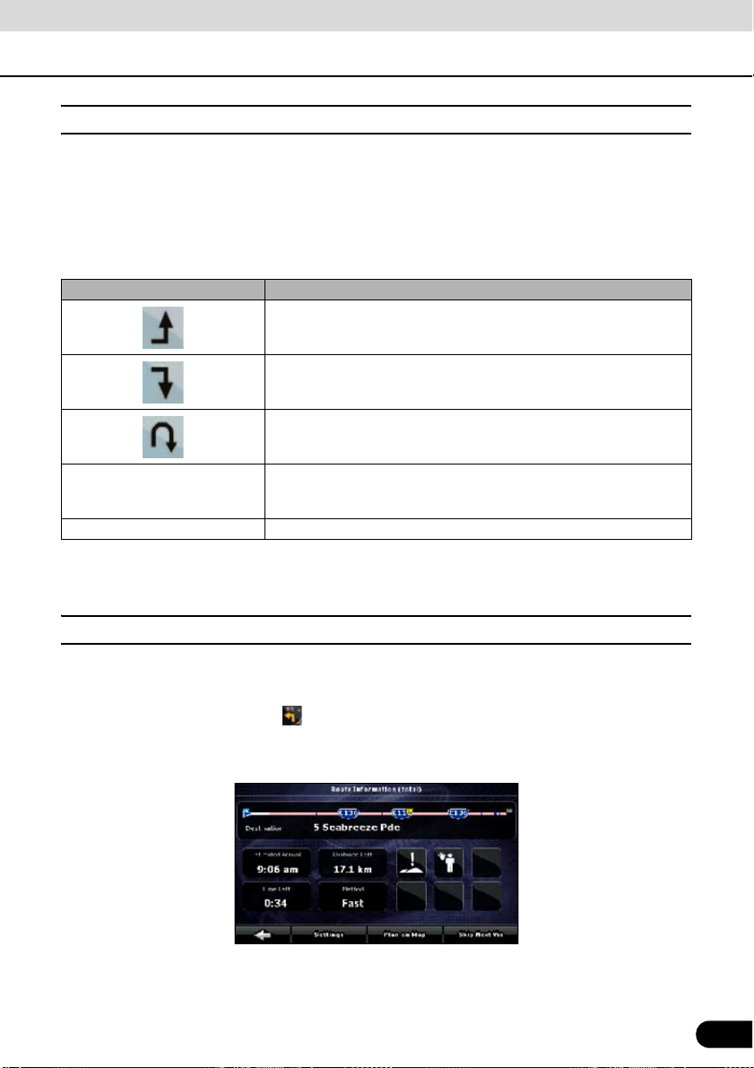
■ Route editing
This feature is available in Advanced mode only.
Touch the following switches: [Menu], [Route], [Edit Route]
A list of route points appears with the start point at the top of the list and the final destination at
the bottom. If several via points exist, you might need to scroll between pages.
Touch one of the route points in the list. You have the following options:
Touch switch Description
The selected point moves up in the list (becomes a via point to be
reached earlier). Repeatedly touching this switch will make this point
the start point.
The selected point moves down in the list (becomes a via point to be
reached later). Repeatedly touching this switch will make this point the
final destination.
Reverses the route. The start point becomes the destination, the
destination becomes the start point, and the order of the via points is
reversed.
[Optimize] The route is optimized. The start point and the destination remain in
[Remove] Touch this switch to remove the selected point from the route.
position, but the via points are reordered to make the shortest possible
route.
As soon as you leave this screen, the route is recalculated automatically, and you can start
navigating right away.
■ Route information screen
The Route information screen has all the data and some of the functions you need while you
navigate. There are two ways to open this screen:
● Touch the Turn Preview field ( ) to open directly from the Map screen.
● In the Advanced mode, touch the following switches from the Navigation menu: [Route],
[Route Info]
In the top section of the screen you see information about the current route. The fields on this
screen are continuously updated while the screen is open.
When you open the screen, all fields contain information about reaching your final destination.
85
85
Page 88

Operation
Navigation Overview
Touch any of the fields to see data on the via points starting from the first one through the final
destination.
This screen includes following data and features:
Name Description Function
Route Line The upper part of this screen shows your
planned route as a horizontal line. The
point at the left end represents the route
starting point and the point at the right
end represents the final destination. The
flags of the via points along the line are
separated by intervals proportional to the
distances between them.
Estimated Arrival Shows the estimated arrival time at the
final destination of the route based on
information available for the remaining
segments of the route. The calculation
cannot take into account traffic jams and
other possible delays.
Distance Left Shows distance left to final destination. Touch this field to change the
Time Left Shows the time needed to reach the final
destination of the route based on
information available for the remaining
segments of the route. The calculation
cannot take into account traffic jams and
other possible delays.
Method This field shows how the route was
calculated.
The route type (fast, short, simple, or
economical) is displayed here.
Warning icons In these square fields graphical symbols
are displayed in the case that warnings
are attached to the planned route. These
are warnings, so icons always show
information for the whole route, even if
the data fields only display values from
your present position to a via point.
[Settings] Opens the Route planning options
[Plan on Map] Opens the Map screen designed for
[Skip Next Via] Appears only if at least one via point
exists.
[Delete Route] Only appears when the route contains no
via points.
Touch this field to change the
content of all data fields to via point
information.
Touch this field to change the
content of all data fields to via point
information.
content of all data fields to via point
information.
Touch this field to change the
content of all data fields to via point
information.
Touch this field to change the
content of all data fields to via point
information.
Touch any of the icons for an
explanation.
screen from the Settings menu.
route planning.
Deletes the next via point from the
route.
Deletes the active route.
86
86
Page 89

■ Facility information, storage, and revision
A point of interest (POI) is a location that someone might find useful or interesting. Navigation
comes with several thousand POIs included. You can create POIs independently in the
application.
POI locations are marked on the map with special icons. POI icons are quite large so you can
easily recognize the symbol. The icons are semi-transparent. They do not hide the streets and
intersections behind them.
POIs are grouped into several levels of categories and subcategories. The icon of POIs that
come with the map shows the symbol of the POI category. If you save your own POI, you can
select an icon for it independently of the POI category you have put it in.
Saving POIs
To save a POI, place the Cursor ( ) at the desired location, then touch the following switches:
[Cursor], [More Options], [Save as POI]
Managing POIs
You can select which POI groups to show and which ones to hide on the map, and from which
zoom levels POI icons are visible. At the same place, you can manage your saved POIs. A
saved POI can be renamed, moved to a different POI group, its icon can be changed, or a
phone number and additional information can be added to it. Touch the following switches:
[Menu], [Manage], [POI]
■ Managing saved search criteria
You can manage the list of previously saved search criteria to easily find frequently searched
POI types. Touch the following switches: [Menu], [Manage], [Saved Search Criteria]
Touch switch Description
Switch with the name of the
Saved Search Criteria
[Clear All] Deletes the entire list.
[<Add new search>] Touch to save new search criteria. In the same way as you search for
Touch to rename the saved query.
Deletes the selected item in the list.
Turns the page for view of other list items.
POIs, first select the search reference, then select the POI group or
subgroup to search in.
87
87
Page 90

Operation
Navigation Overview
Using Keyboard Screen
You only need to enter letters or numbers in Navigation when you cannot avoid it. You can type
with your fingertips on the full-screen keyboards and you can switch between various keyboard
layouts, for example ABC, QWERTY, or numerical.
Task Description
Switching to another keyboard layout, for example
from an English QWERTY keyboard to a Greek
character keyboard
Correcting an entry on the keyboard
Entering a space, for example between a first name
and a family name or in multi-word street names
Entering lowercase or capital letters Touch [aA] to cycle through entering lowercase
Entering symbols Touch [@/!] to switch to a keyboard offering symbol
Finalising the keyboard entry Touch [Done].
Touch [US ENGLISH (QWERTY)] to select it from
the list of available keyboard types.
Navigation remembers your last keyboard choice
and offers it the next time you need to enter data.
Delete an unwanted character: Touch .
Touch and hold the switch to delete the entire
string.
Touch [Space].
letters, initial capitals and all capitals.
characters.
88
88
Page 91

Navigation Guidance
CHECK
ATTENTION
Navigation Guidance
You can set up your route in Navigation in several ways:
● if you need a simple route (a route with only one destination and without any intermediate via
points), you can select the destination and start navigating to it right away.
● You can plan a multi-point route (available in Advanced mode only).
● You can also plan a route independently of your current GPS position or even without GPS
reception (available in Advanced mode only)
Destination Setting Setting from Map Scroll
Navigation offers you several ways of
choosing your destination and via points
(intermediate destinations).
● Use selected location (Cursor) on the Map
(See page 89).
● Enter an address or part of an address.
For example, enter a street name rather
than a house number or the names of two
intersecting streets (See page 90).
● Enter an address with Postcode (See page
95). In this case, there in not need to select
a city name. This will speed up the search
for a street name.
● Use coordinates (See page 98)
● A Favorite (See page 96)
● A POI (See page 96)
● From a history of set destinations and
intermediate points (See page 98)
If you are going to use a route later, save it
before you start navigating. Touch the
following switches: [Menu], [Route], [Save
Route]
Locate your destination on the map.
1
Move and scale the map as needed
(See page 66).
Touch the location that you want to
2
select as your destination. The Cursor
( ) appears.
Touch [Cursor] to open the Cursor
3
menu.
The map appears with the selected
4
point in the middle. From the Cursor
menu, touch [Set as Destination]
(Advanced mode). The route is then
automatically calculated, and you can
start navigating.
When you wish to use the destination later,
save it as a POI from the Cursor menu and
then add it to your list of Favorites.
The Cursor menu returns automatically with
the same point. Now you can use it as a route
point.
89
89
Page 92

Navigation Guidance
Navigation Guidance
Setting from Address
If you know at least a part of the address, this
is the quickest way to select the destination of
the route.
Using the same screen, you can find an
address by entering:
● The exact address, including house
number
● A city center
● An intersection
● The midpoint of a street
● Any of the above, starting the search with
the Postcode (See page 95)
■ Entering Address
In some countries, a state name may be
included in the address. If Australia is
selected, 5 lines appear on the screen.
If New Zealand is selected, 4 lines appear on
the screen.
By default, Navigation proposes the
2
country/state and city where you are. If
needed, touch the switch with the
name of the country on it, and select a
different one from the list. When
selecting a new country, you need to
either select a state or, to search for a
city regardless of your current state,
touch [<All states>].
Even when you do not change
3
countries, you may change state or
suburb. Touch the state name or
suburb name switch, and select from
the list.
If needed, change the city.
4
● To select the city from the list of recently
used ones, touch the switch.
Touch the following switches. After
5
changing the country/state, touch
[<Enter Suburb/Town Name>].
90
Touch the following switches: [Find
1
Address] (Advanced mode)
90
● Start entering the city name on the key
board.
● After entering a couple of characters, the
names that match the string appear in a
list.
● Touch [Done] to open a list of results
before one appears automatically.
Pick the city from the list.
6
Page 93

Touch [<Street Name>].
7
■ Entering addresses for repeating house number allocation
● Start entering the street name on the
keyboard.
● After entering a couple of characters, the
names that match the string appear in a
list.
● Touch [Done] to open a list of results
before one appears automatically.
Select the street from the list.
8
Touch [<House Number>].
9
● Enter the house number on the keyboard.
Touch [Done] to finish entering the
10
address.
The map appears with the selected
11
point in the middle. From the Cursor
menu, touch [Set as Destination]
(Advanced mode). The route is then
automatically calculated, and you can
start navigating.
On some long roads house numbering is
restarted at some point. Hence, the same
house number can appear twice or even
more times on the same road. If this is the
case, after entering the house number, you
need to select the appropriate address by the
district/suburb information.
Touch the following switches: [Find],
1
[Find Address] (Advanced mode).
By default, Navigation proposes the
2
country/state and city where you are. If
needed, touch the switch with the
name of the country/state, and select a
different one from the list.
If needed, change the city.
3
● To select the city from the list of recently
used ones, touch the switch.
Touch the following switches. After
4
changing the country/state, touch
[<Enter Suburb/Town Name>].
91
● Start entering the city name on the key
board.
● After entering a couple of characters, the
names that match the string appear in a
list.
● Touch [Done] to open a list of results
before one appears automatically.
Pick the city from the list.
5
91
Page 94

Navigation Guidance
Navigation Guidance
Touch [<Street Name>].
6
● Start entering the street name on the
keyboard.
● After entering a couple of characters, the
names that match the string appear in a
list.
● Touch [Done] to open a list of results
before one appears automatically.
Select the street from the list.
7
Touch [<House Number>].
8
● Enter the house number on the keyboard.
Touch [Done] to finish entering the
9
address.
A list appears with the matching
10
addresses. Touch the desired one.
The map appears with the selected
11
point in the middle. From the Cursor
menu, touch [Set as Destination]
(Advanced mode). The route is then
automatically calculated, and you can
start navigating.
■ Entering address without knowing district or suburb
Long roads can run across several districts or
suburbs. You may not know what particular
house number is located where. In this case,
follow the instructions below.
Touch the following switches: [Find],
1
[Find Address] (Advanced mode).
By default, Navigation proposes the
2
country/state and city where you are. If
needed, touch the switch with the
name of the country/state, and select a
different one from the list.
If needed, change the city.
3
● To select the city from the list of recently
used ones, touch the switch.
Touch the following switches. After
4
changing the country/state, touch
[<Enter Suburb/Town Name>].
● Start entering the city name on the key
board.
● After entering a couple of characters, the
names that match the string appear in a
list.
● Touch [Done] to open a list of results
before one appears automatically.
92
92
Pick the city from the list.
5
Page 95

Touch [<Street Name>].
6
■ Selecting from intersection
● Start entering the street name on the
keyboard.
● After entering a couple of characters, the
names that match the string appear in a
list.
● Touch [Done] to open a list of results
before one appears automatically.
Instead of selecting one of the streets,
7
touch [Search in All].
Touch [<House Number>].
8
● Enter the house number on the keyboard.
Touch [Done] to finish entering the
9
address.
A list appears with the matching
10
addresses. Touch the desired one.
The map appears with the selected
11
point in the middle. From the Cursor
menu, touch [Set as Destination]
(Advanced mode). The route is then
automatically calculated, and you can
start navigating.
Touch the following switches: [Find],
1
[Find Address] (Advanced mode).
By default, Navigation proposes the
2
country/state and city where you are. If
needed, touch the switch with the
name of the country/state, and select a
different one from the list.
If needed, change the city.
3
● To select the city from the list of recently
used ones, touch the switch.
Touch the following switches. After
4
changing the country/state, touch
[<Enter Suburb/Town Name>].
● Start entering the city name on the
keyboard.
● After entering a couple of characters, the
names that match the string appear in a
list.
● Touch [Done] to open a list of results
before one appears automatically.
Pick the city from the list.
5
93
93
Page 96

Navigation Guidance
Navigation Guidance
Touch [<Street Name>].
6
● Start entering the street name on the
keyboard.
● After entering a couple of characters, the
names that match the string appear in a
list.
● Touch [Done] to open a list of results
before one appears automatically.
Select the street from the list.
7
Touch [Intersection].
8
● If only a few intersecting streets exist, a list
of them appears immediately.
● For longer streets, a keyboard screen
appears. Start entering the name of the
intersecting street on the keyboard. As you
type, if the matching streets can be shown
on one screen, a list of them appears
automatically.
Touch the desired intersecting street
9
in the list.
The map appears with the selected
10
point in the middle. From the Cursor
menu, touch [Set as Destination]
(Advanced mode). The route is then
automatically calculated, and you can
start navigating.
■ Selecting from city center
The City Center is not the geometric center of
the city but an arbitrary point the map
creators have chosen. In towns and villages,
it is usually chosen to be the most important
intersection. In large cities, it is an important
intersection.
Touch the following switches: [Find],
1
[Find Address] (Advanced mode).
By default, Navigation proposes the
2
country/state and city where you are. If
needed, touch the switch with the
name of the country/state, and select a
different one from the list.
If needed, change the city.
3
● To select the city from the list of recently
used ones, touch the switch.
Touch the following switches. After
4
changing the country/state, touch
[<Enter Suburb/Town Name>].
● Start entering the city name on the
keyboard.
● After entering a couple of characters, the
names that match the string appear in a
list.
● Touch [Done] to open a list of results
before one appears automatically.
94
94
Pick the city from the list.
5
Page 97

Touch [City Centre].
6
Pick the city from the list.
4
The map appears with the selected
7
point in the middle. From the Cursor
menu, touch [Set as Destination]
(Advanced mode). The route is then
automatically calculated, and you can
start navigating.
■ Selecting from Postcode
All of the above address searching
possibilities can be performed when entering
the Postcode instead of the city name. The
following is an example for a full address.
Touch the following switches: [Find],
1
[Find Address] (Advanced mode).
By default, Navigation proposes the
2
country/state and city where you are. If
needed, touch the switch with the
name of the country/state, and select a
different one from the list.
Touch the City Name switch, and enter
3
the Postcode.
● Start entering the Postcode on the
keyboard.
● After entering a couple of numbers,
matching city names appear in a list.
● Touch [Done] to open a list of results
before one appears automatically.
Touch [<Street Name>].
5
● Start entering the street name on the
keyboard.
● After entering a couple of characters, the
names that match the string appear in a
list.
● Touch [Done] to open a list of results
before one appears automatically.
Select the street from the list.
6
Touch [<House Number>].
7
● Enter the house number on the keyboard.
Touch [Done] to finish entering the
8
address.
The map appears with the selected
9
point in the middle. From the Cursor
menu, touch [Set as Destination]
(Advanced mode). The route is then
automatically calculated, and you can
start navigating.
95
95
Page 98

Navigation Guidance
Navigation Guidance
■ Entering quick address
● When you are entering the name of a city
or a street, Navigation only displays those
characters that appear in possible search
results. The other characters are grayed
out.
● To enter a city or street name, enter a few
letters and then touch [Done]. Navigation
will display a list including the entered
letters.
● You can speed up finding an intersection.
● Search for the rare or less common name
first. A few letters should be sufficient.
● If one of the streets is shorter, search for
that one first. You can then find the second
one faster.
● You can search using both the type and
the name of the roads. If the same word
appears in several names, for example in
the name of streets, roads and avenues,
you can obtain the result faster if you enter
the first letter of the street type. For
example, enter Pi A to obtain Pine Avenue
and skip all Pine Streets and Pickwick
Roads.
● You can also search in Postcode. This is
useful when a street name is common and
it is used in several districts of a city.
Setting from Favorites
You can select a location that you have
already saved as a Favorite to be your
destination.
Touch the following switches: [Find],
1
[Favourites] (Advanced mode).
Touch the Favorite you wish to set as
2
your destination.
The map appears with the selected
3
point in the middle. From the Cursor
menu, touch [Set as Destination]
(Advanced mode). The route is then
automatically calculated, and you can
start navigating.
Setting from Facility Information
■ Selecting from facility information
You can select your destination from the
POIs included with Navigation or from the
ones you have previously created.
96
96
Touch the following switches: [Find],
1
[Find POI] (Advanced mode).
Page 99

Select the area in which to search for
2
the POI.
When the list of results appears, you
4
can sort the list.
● [Around Address]: The POI will be
searched for around a given address.
● [Around Cursor]: The map appears with
the Cursor in the middle. Modify the
location of the Cursor if necessary, then
touch [OK]. The POI will be searched for
around the given location.
● [Around GPS Position]: The POI will be
searched for around the current GPS
position.
● [Around Destination]: The POI will be
searched for around the destination of the
active route.
● [Along Route]: The POI will be searched
for not around a given point, but by the
size of the detour it adds to the active
route. This is useful when searching for
stop offs which can be reached with a
minimal detour. Examples of such stop
offs include restaurants and gasoline
stands.
You can narrow the search with the
3
following:
● Select the POI group (e.g.
Accommodation), and after that, if needed,
select the POI subgroup (e.g. Hotel or
Motel).
● To find the POI by its name, touch [Search]
, and use the keyboard to enter a part of
the name.
● To list all POIs in a given group, touch [List
All in this Group].
● [Order by Name: Sort the list alphabetically
(available when you search around a
single location).
● [Order by Distance]: Sort the list by the
straight-line distance from your present
position (available when you search
around a single location).
● [Order by Distance]: Sort the list by the
distance to drive on the route from your
present position (available when you
search along the active route).
● [Order by Detour]: Sort the list by the size
of the needed detour (available when you
search along the active route).
Touch the desired POI in the list.
5
Touch [Select].
6
The map appears with the selected
7
point in the middle. From the Cursor
menu, touch [Set as Destination]
(Advanced mode). The route is then
automatically calculated, and you can
start navigating.
97
97
Page 100

Navigation Guidance
Navigation Guidance
■ Select from saved facility information search criteria
Your can save POI search criteria in the POI
section of the Manage menu. However,
Navigation also comes with a number or presaved criteria which can be used immediately
to search for POIs.
Touch the following switches: [Find],
1
[Find POI] (Advanced mode).
Touch [Saved Search Criteria].
2
Select one of the saved criteria, and a
3
list of matching POIs appears.
Touch the desired POI in the list.
4
The map appears with the selected
5
point in the middle. From the Cursor
menu, touch [Set as Destination]
(Advanced mode). The route is then
automatically calculated, and you can
start navigating.
The map appears with the selected
4
point in the middle. From the Cursor
menu, touch [Set as Destination]
(Advanced mode). The route is then
automatically calculated, and you can
start navigating.
Setting from Coordinates
This feature is available in Advanced mode
only.
Touch the following switches: [Find],
1
[Find Coordinate]
● Touch [Coordinate Display Format] to
change the format of the displayed
coordinates.
Touch longitude or latitude values to
2
change the coordinates.
Enter the coordinate values in the
3
WGS84 format: The latitude (N or S)
and the longitude (E or W).
Touch [Done].
4
Setting from History
Past destinations are appear in the History.
Touch the following switches: [Find],
1
[History] (Advanced mode).
If necessary, move between pages
2
with to see past destinations.
Touch the desired item.
3
98
98
Touch [OK].
5
The map appears with the selected
6
point in the middle. From the Cursor
menu, touch [Set as Destination]
(Advanced mode). The route is then
automatically calculated, and you can
start navigating.
 Loading...