

Page 1

2005 Cadillac STS Navigation System M
Overview
Overview
Features and Controls
Features and Controls
Navigation Audio System
Navigation Audio System
........................................................ 1-1
.................................................. 1-2
..................................... 2-1
................................ 2-2
................................ 3-1
............................ 3-2
Voice Recognition
Voice Recognition
Vehicle Customization
Vehicle Customization
Phone
Index
............................................................ 6-1
Phone
...................................................... 6-2
................................................................ 1
........................................... 4-1
...................................... 4-2
..................................... 5-1
................................. 5-2
Page 2

GENERAL MOTORS, GM, the GM Emblem, CADILLAC,
the CADILLAC Crest &Wreath,andthe name STS are
registered trademarks of General Motors Corporation.
DTS and DTS Digital
Surround are registered
trademarks of Digital
Theater Systems, Inc.
The information in this manual supplements the owner
manual. This manual includes the latest information
available at the time it was printed. We reserve the right
to make changes in the product after that time
ithout notice.
Keep this manual with the owner manual in the vehicle,
so it will be there if it is needed. If the vehicle is sold,
leave this manual in the vehicle.
Litho in U.S.A.
Part No. 10376371 B First Edition
ii
©
2004 General Motors Corporation. All Rights Reserved.
Page 3

Section 1 Overview
Overview .........................................................1-2
Navigation System Overview ............................1-2
Getting Started ...............................................1-4
1-1
Page 4
Overview
Navigation System Overview
1-2
Page 5

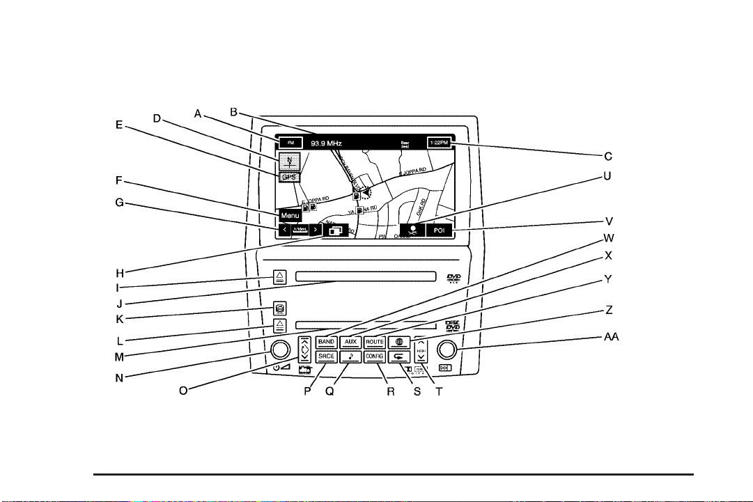
A. Audio Source Screen Button. See Navigation Audio
System on page 3-2 for more information.
B. Audio Status Line
C. Clock. See “Clock” under Configure Menu on
page 2-55 for more information.
D. North Up/Heading Up Symbol. See Symbols on
page 2-8 for more information.
E. No GPS Symbol. See Symbols on page 2-8 for more
information.
F. Navigation Menu Symbol. See Navigation Menu on
page 2-18 for more information.
G. Map Scales. See “Map Scales” under Maps on
page 2-6 for more information.
H. Guidance Window Symbol. See Symbols on
page 2-8 for more information.
I. Map DVD Eject Key. See “Hard Keys” under Using
the Navigation System on page 2-2 for more
information.
J. Map DVD Loading Slot.
K. CD/DVD Changer Loading Key. See Six-Disc
CD/DVD Changer on page 3-13 for more information.
L. CD/DVD Changer Eject Key. See Six-Disc CD/DVD
Changer on page 3-13 for more information.
M. CD/DVD Changer Loading Slot.
N. Power/Volume Knob. See “Hard Keys” under Using
the Navigation System on page 2-2 for more
information.
O. Navigation Screen Tilt Key (in/out). See “Hard Keys”
under Using the Navigation System on page 2-2
for more information.
P. SRCE (Source) Key. See Six-Disc CD/DVD Changer
on page 3-13 for more information.
Q. Audio Key. See Six-Disc CD/DVD Changer on
page 3-13 for more information.
R. CONFIG Key. See Configure Menu on page 2-55 for
more information.
S. Navigation Voice Prompt Repeat Key. See “Hard
Keys” under Using the Navigation System on
page 2-2 for more information.
1-3
Page 6

T. Seek/Scan Key (up/down). See Six-Disc CD/DVD
Changer on page 3-13 for more information.
U. Memory Point Symbol. See Symbols on page 2-8 for
more information.
V. POI Symbol (Point of Interest). See Symbols on
page 2-8 for more information.
W. BAND Key. See Six-Disc CD/DVD Changer on
page 3-13 for more information.
X. AUX (Auxiliary) Key. See “Hard Keys” under Using
the Navigation System on page 2-2 for more
information.
Y. ROUTE Key. See Destination on page 2-37 for more
information.
Z. Map Key. See “Hard Keys” under Using the
Navigation System on page 2-2 for more information.
AA. Tune Knob. See Six-Disc CD/DVD Changer on
page 3-13 for more information.
Getting Started
Before you begin to operate the navigation system, read
this manual thoroughly to become familiar with it and
to understand how the system works.
The navigation system allows you to do the following:
• Plan a route with provided turn-by-turn route
and map guidance with voice prompts.
• Select a destination using various methods and
choices.
• Receive broadcast announcements on traffic and
emergency alert communications.
The information in the system may not always be
complete. Road conditions such as prohibited turns,
detours, and construction zones, change frequently.
It is important to consider whether you can follow
the directions given by the system for the current
conditions.
1-4
Page 7
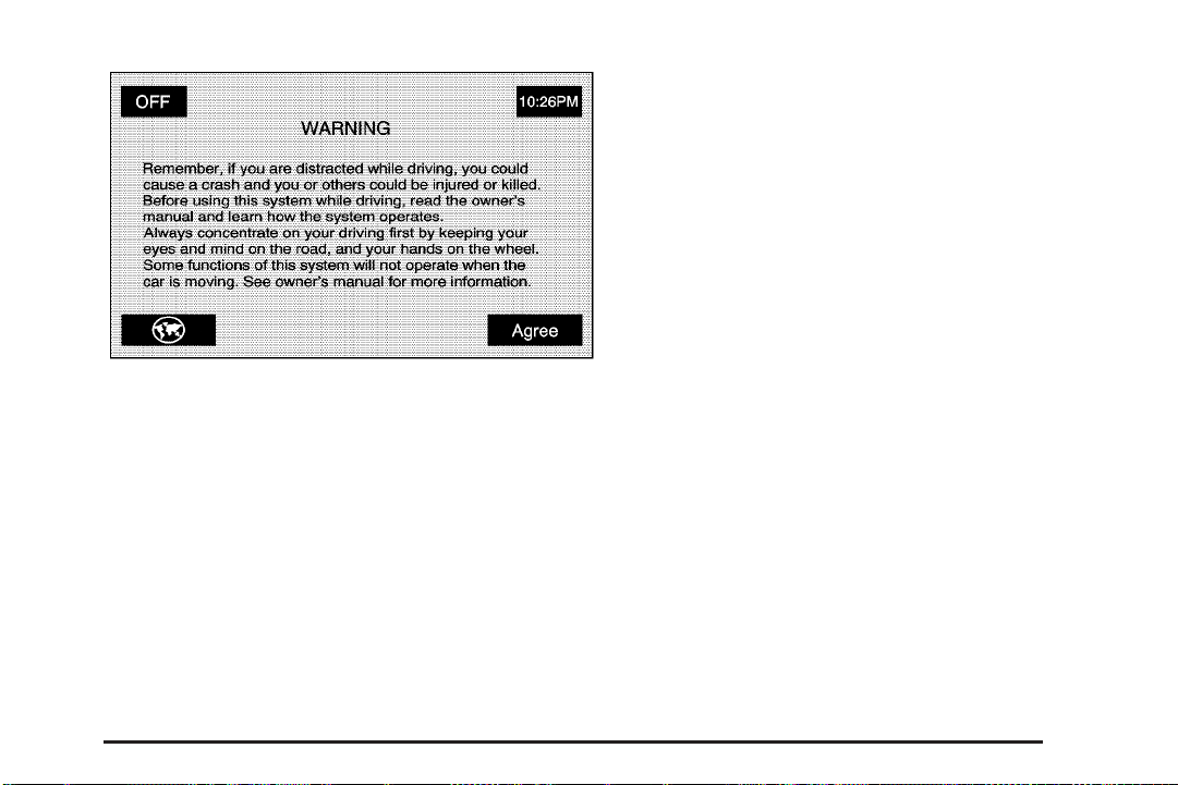
Each time you first start your vehicle and turn on the
navigation system by touching the map hard key,
you will see this screen. You can touch Agree to
proceed into the system, or the globe symbol in the
lower left corner of the screen to change the language
of the system. For more information on changing
the language, see Personalization on page 5-2.
When getting started you may set the navigation system
to your preference using various options. To do so,
reference the following topics:
• To adjust screen appearance, see “Screen
Appearance” under Configure Menu on page 2-55.
• To adjust the clock and other time options,
see “Clock” under Configure Menu on page 2-55.
• To plan a route, see Destination on page 2-37.
• To adjust the volume of voice guidance prompts or
voice recognition, see “Navigation Set Up” under
Configure Menu on page 2-55.
1-5
Page 8

✍ NOTES
1-6
Page 9

Section 2 Features and Controls
Features and Controls ......................................2-2
Using the Navigation System ...........................2-2
Maps ............................................................2-6
Symbols ........................................................2-8
Navigation Menu ...........................................2-18
Destination ..................................................2-37
Keyless Access System .................................2-53
®
OnStar
System ...........................................2-54
Configure Menu ............................................2-55
Global Positioning System (GPS) ....................2-64
Vehicle Positioning ........................................2-64
Problems with Route Guidance .......................2-65
If the System Needs Service ..........................2-66
Ordering Map DVDs ......................................2-66
Database Coverage Explanations ....................2-66
2-1
Page 10

Features and Controls
Using the Navigation System
This section presents basic information you will need to
know to operate the navigation system.
Use the hard keys located on the navigation system
along with the available touch screen buttons on
the navigation screen to operate the system.
See Navigation System Overview on page 1-2 for
more information.
Once the vehicle is moving, various functions will be
disabled to reduce driver distractions.
Hard Keys
The following hard keys are located on the navigation
system:
Z (Map DVD Eject): Press the eject key located
next to the map DVD loading slot to eject the map DVD.
The map DVD slot is the slot directly below the display
screen.
M (Load): Press the CD/DVD changer loading key to
go to the loading screen and begin loading DVDs or
CDs. See Six-Disc CD/DVD Changer on page 3-13 for
more information.
Z (CD/DVD Eject): Press the eject key next to the
CD/DVD changer loading slot to begin ejecting DVDs or
CDs. See Six-Disc CD/DVD Changer on page 3-13
for more information.
On (Power/Volume): Press the power/volume
knob to turn the audio system on and off. Turn the knob
to increase or decrease the volume to the audio system.
ymz (Tilt): Press the up arrow on the tilt key to
tilt the navigation screen forward. Press the down arrow
on the tilt key to tilt the screen rearward. There are
three tilt positions to choose from.
BAND: Press the BAND key to change bands.
The BAND key will toggle among the bands available,
FM, AM, XM, and WX. See Navigation Audio System
on page 3-2.
SRCE (Source): Press the source key to switch
between the audio sources. Pressing this key will
switch between the radio and the CD/DVD player.
See Navigation Audio System on page 3-2.
AUX (Auxiliary): Press the AUX key to access screens
from which you will operate Bluetooth
control video input. See Bluetooth
®
OnStar
on page 3-23 for more information.
System on page 2-54, and Auxiliary Devices
®
, OnStar®,or
®
Phone on page 6-2,
2-2
Page 11

e (Audio): Press the audio key to access the Audio
Adjust screen, where you can adjust your base,
mid, fade, balance and DSP settings. See Navigation
Audio System on page 3-2.
ROUTE: Press the ROUTE key to access the
Destination Entry screen or the search area and begin
planning a destination. See Destination on page 2-37.
CONFIG (Configure): Press the CONFIG key to access
the desired SET UP Function screen. See Configure
Menu on page 2-55.
) (Map): Press the map key to access the map screen.
k (Navigation Repeat): Press the navigation repeat
key to repeat the last voice guidance prompt, while
you are on a route.
y©¨z (Seek/Scan): Press the seek/scan arrows
to go to the next or previous radio station and stay
there, or press and hold to scan stations. See Navigation
Audio System on page 3-2.
Tune Knob: Turn the tune knob to go to the next or
previous radio station and stay there. See Navigation
Audio System on page 3-2.
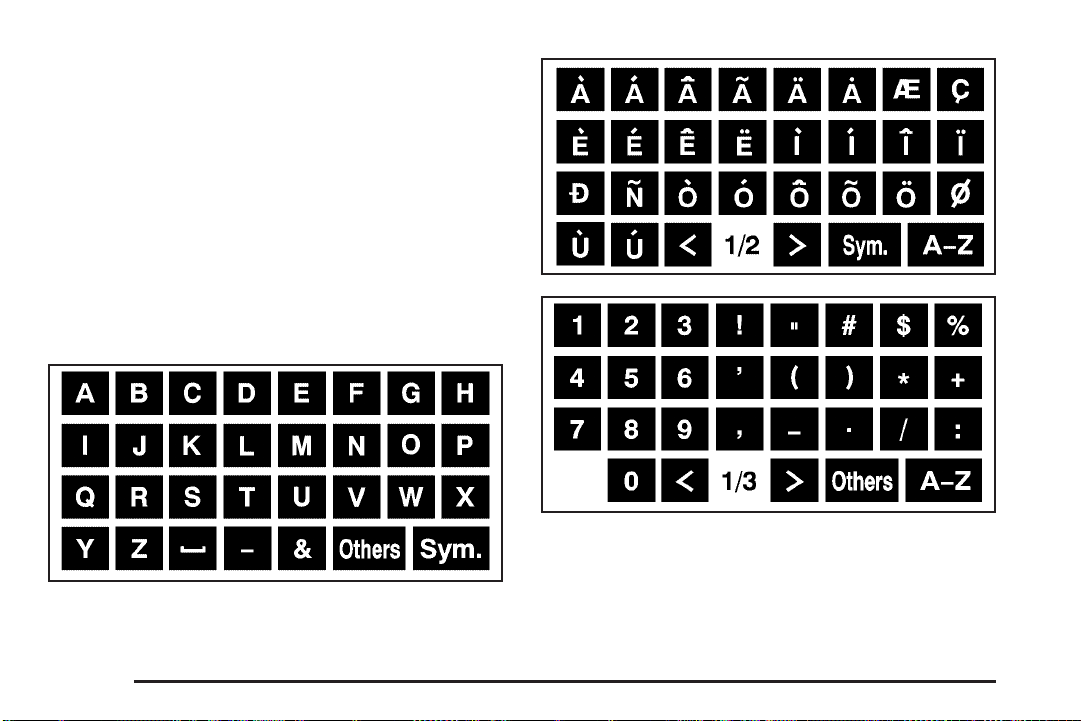
Alpha-Numeric Keypad
Letters of the alphabet, symbols, punctuation, and
numbers, when available to you, will be displayed on
the navigation screen as an alpha or numeric keypad.
The alpha keypad will be displayed when the system
needs you to input a city or street name. You can also
touch the symbol button (Sym.) at the bottom of the
alpha keypad to access the numeric keypad when
inputting a house address, punctuation mark, or other
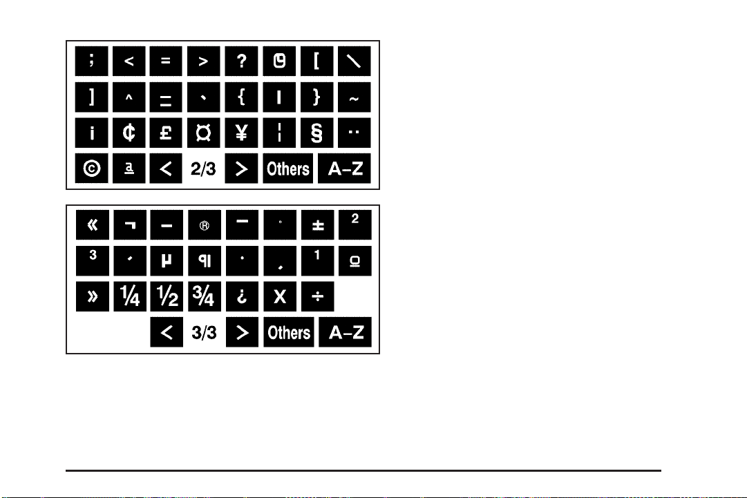
character. There are three pages of different symbols
available. Touch A - Z to return to the alpha keypad.
Touch Others to get to a alpha keypad with special
characters. There are two pages of characters available
under the Others selection. On either the Symbol or
Others screens, using the arrows at the bottom next to
the page numbers will navigate you through the rest
of the screens available.
All characters are touch-sensitive screen buttons.
Touch a character to select it.
U: Select the space symbol on the A - Z screen
to enter a space between characters or the words
of a name.
V: Select the backspace symbol if you have selected
an incorrect character.
2-3
Page 12
To make your name selections easier, the system will
only allow you to select a character which can follow the
last one entered. For example, if you enter Z, you
would not be allowed to follow it with T. The system will
highlight the available characters and darken the
unavailable characters.
If you are unsuccessful when inputting a name, it may
need to be selected differently. It is also possible that the
map DVD database may not contain that information
or the correct search area has not been selected.
See Database Coverage Explanations on page 2-66
for more information.
The following screens are some of the different alpha
keypads you will have access to:
2-4
Page 13
Touch-Sensitive Buttons
Touch-sensitive screen buttons are located on the
screen. When you have successfully selected a screen
button, a beep will sound. These buttons will be
highlighted when a feature is available and dim when
they are unavailable. There are also some toggle screen
buttons that will be light blue when active and dark
blue when inactive.
2-5
Page 14

Maps
This section includes basic information that you need to
know about the map database.
Regional Maps
The maps are stored on a DVD. The 48 contiguous
United States and portions of Canada are contained
on one disc.
If a regional map does not contain a specific city, the map
DVD may not contain the city or it may be misspelled.
Refer to the Navigation System Map Disc manual to
view a detailed explanation of map coverage and
detailed city lists in each region. This manual will be in
your map DVD case when the vehicle is delivered
from the factory.
Installing the Map DVD
When your vehicle is delivered from the factory, the
dealer may have installed the map DVD. If the map DVD
was not installed in your vehicle when first purchased,
use the following directions to load the map DVD:
Read the following steps completely before operating
this feature.
1. Turn the ignition on.
2. Load the map DVD into the slot located just below
the navigation system screen by inserting it partially
until the system pulls it in.
Once the map DVD is inserted correctly, you will have
the following two choices:
Agree: Touch this screen button to proceed to the
navigation system.
^ (Language): Touch this screen button to change
the language of the navigation system, DIC, HUD,
etc. See “Language” under Personalization on page 5-2
for more information.
Once a language has been selected, touch Agree to
enter the navigation system. The map will appear
showing your current vehicle position.
Setting the Search Area
See Destination on page 2-37 for information on
changing the search area.
Map Adjustments
The system allows you to adjust the scale of view
on the map. Also, as you drive, the map will scroll
automatically based on the direction you are traveling.
2-6
Page 15
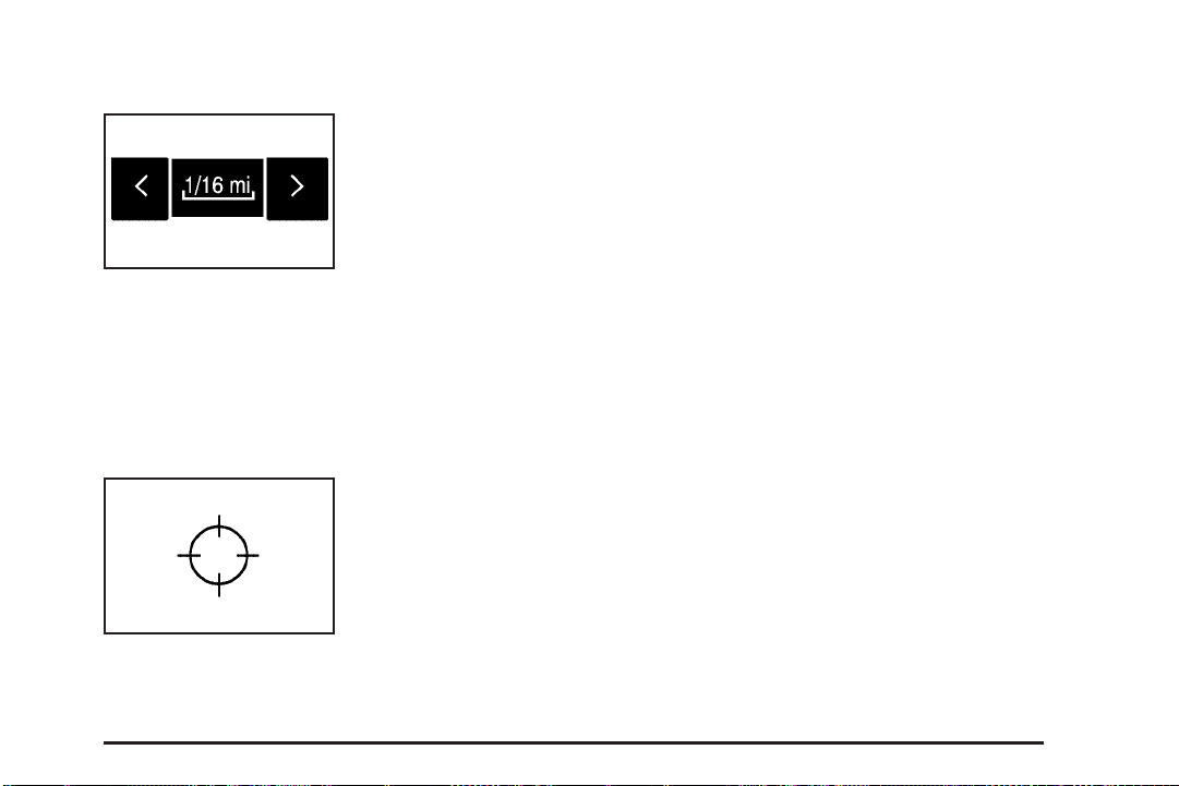
Map Scales
To view a larger or smaller
scale of the map, touch
the map scale arrows.
You can change the level of map detail by either zooming
in or zooming out using the arrow screen buttons or by
touching the scale on the bar. The system will adjust the
map accordingly. The scale of a map can range from
1/32 of a mile (50 m) to 128 miles (256 km).
Scrolling the Map
Touch anywhere on the
map screen twice and the
scroll symbol will appear.
Use this feature to
scroll across the map.
You can hold your finger in any direction outside of the
scroll symbol and the map will continue to scroll in
that direction until you remove your finger from the
map screen.
If scrolling while your vehicle is in PARK (P), the system
will scroll initially at a slower rate. It will increase if
you continue touching the map screen.
If scrolling while your vehicle is in motion, you have
one scroll speed and a limited distance to scroll. Keep
touching the map screen to scroll for a longer distance.
If you have used the scroll feature to scroll the map and
your vehicle icon becomes lost, press the map hard key
to return to the current vehicle location on the map.
When scrolling on the map, the system will display the
address of the scroll symbol location and the distance
from your vehicle’s current position to the scroll symbol
location.
Use the scroll feature on the map to set a destination.
See “Map” under Destination on page 2-37 for more
information.
2-7
Page 16
Symbols
The following symbols are the most common symbols
that will appear on a map screen.
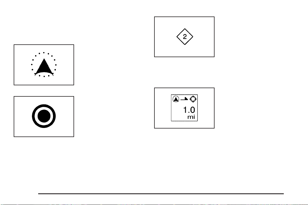
Your vehicle is shown as
this symbol. It indicates the
current position and
heading direction of your
vehicle on the map.
The destination symbol will
appear on the map after a
route has been planned
marking your final
destination.
The waypoint symbol will
be displayed on the map
after a waypoint has
been added to your route.
The waypoint symbol will be numbered from one
through five depending on how many waypoints have
been set.
The distance to destination
symbol indicates the
distance to your final
destination. It only appears
when time is not available
or when you are scrolling
on the map.
2-8
Page 17
The distance and time
to destination symbol
indicates the distance and
the estimated time
remaining to your final
destination or arrival time,
depending on the option
selected. See Configure
Menu on page 2-55
for more information.
The straight line to
distance symbol shows the
straight-line distance to
your destination.
This symbol will appear before you start driving on
the route or if you are on a road where navigation
guidance cannot be given.
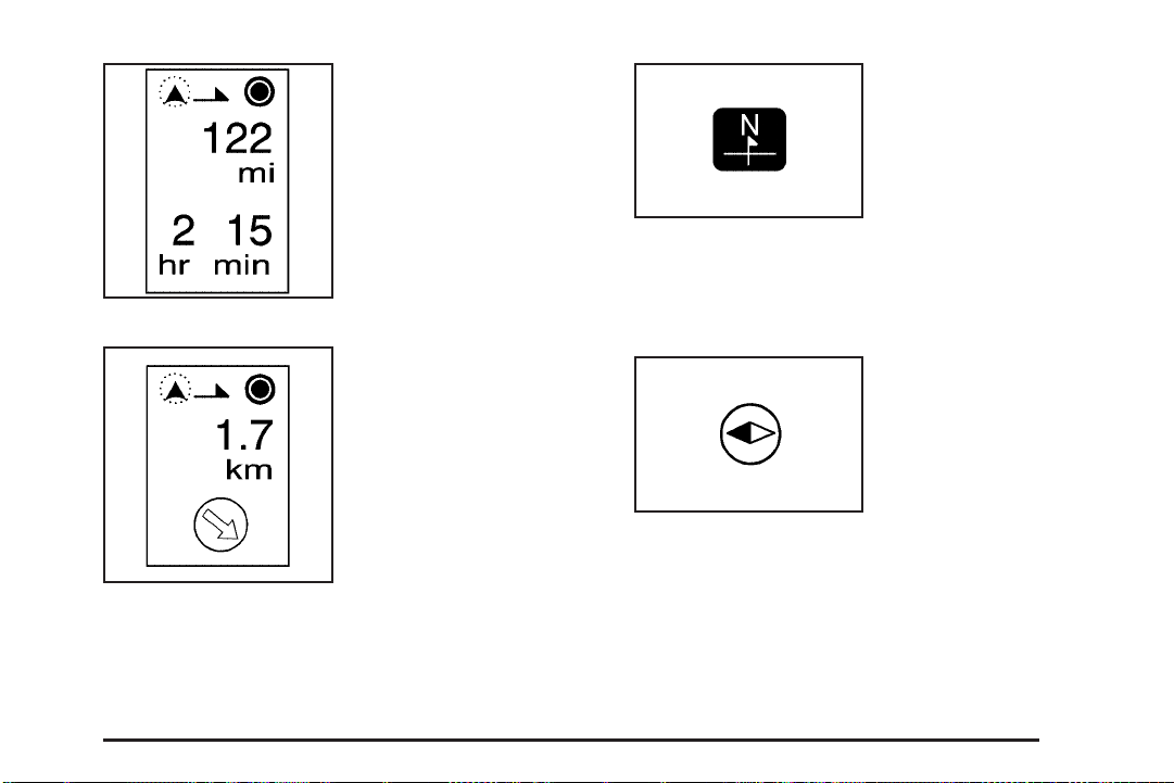
The north up symbol
indicates the map with
North Up, known as
North Up mode.
While in North Up mode, the vehicle icon will follow the
north direction on the map regardless of which direction
the vehicle is traveling. Select this screen symbol to
switch between North Up and Heading Up modes.
The heading up symbol
indicates the map with the
vehicle travel direction
up, known as Heading
Up mode.
The shaded triangle indicates the North direction.
While in Heading Up mode, the direction your vehicle is
traveling will always be at the top of the map screen.
The vehicle icon will always be headed in the direction
your vehicle is traveling. Select this screen symbol
to switch between Heading Up and North Up modes.
2-9
Page 18
The No GPS symbol will
appear, in the upper right
corner of the map
screen, when your vehicle
is not receiving a Global
Positioning System (GPS)
satellite signal.
See Global Positioning System (GPS) on page 2-64
for more information.
When a name is too long
to be displayed, an arrow
symbol will appear.
Select the right or left
arrow screen button
to scroll through the
entire name.
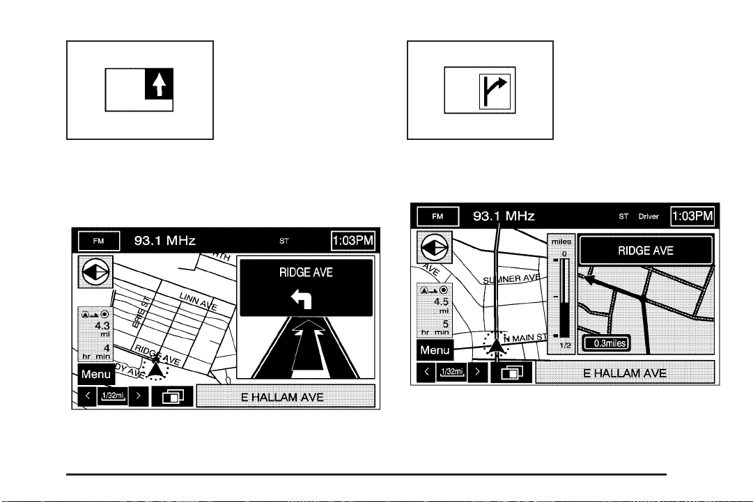
This symbol indicates the
position of the next
guidance maneuver.
The following symbols can also be found on a map
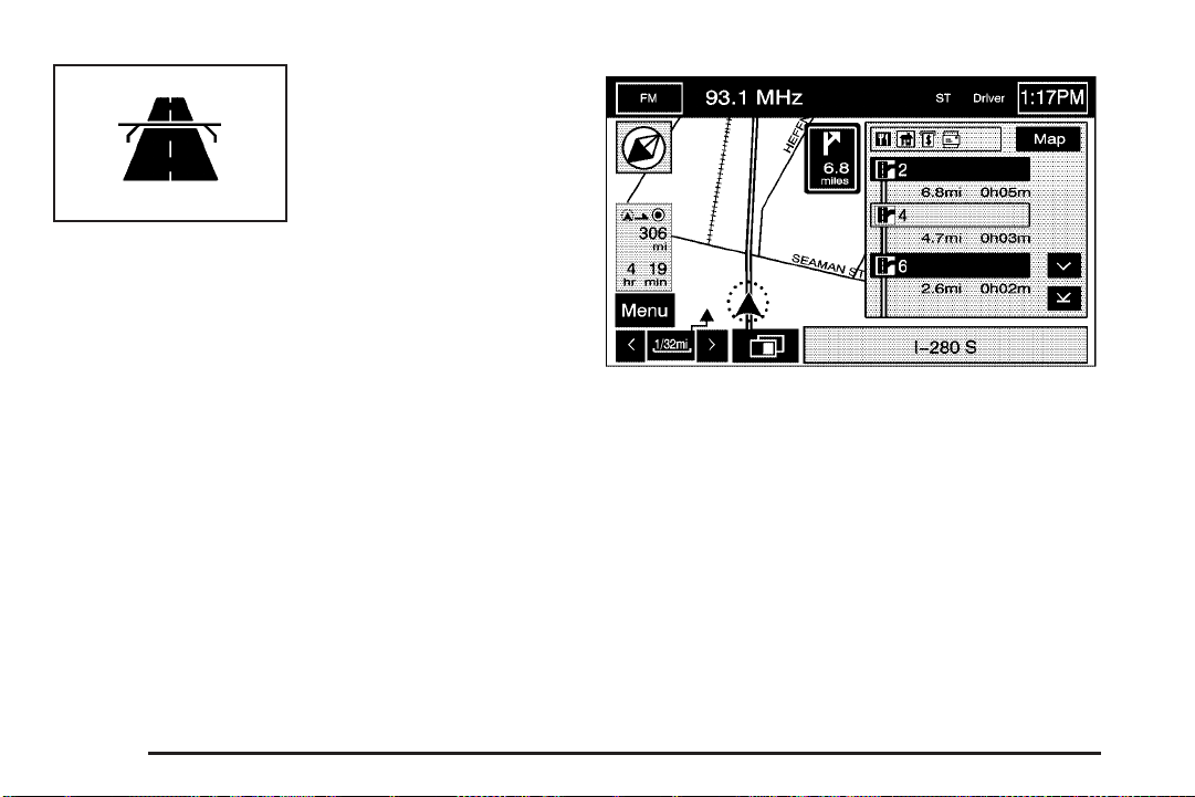
screen:
Select the waypoint
symbol to enter a waypoint
along the current route.
This allows you to
have more than one
destination planned at
a time.
2-10
Page 19
Touch anywhere on the
map to display this button.
Select the memory
point symbol to store the
location on the screen as a
memory point.
The system will automatically store the memory point in
the Marked Point folder/category.
Touch anywhere on the
map to display the POI
screen button on the
bottom right corner of the
map screen.
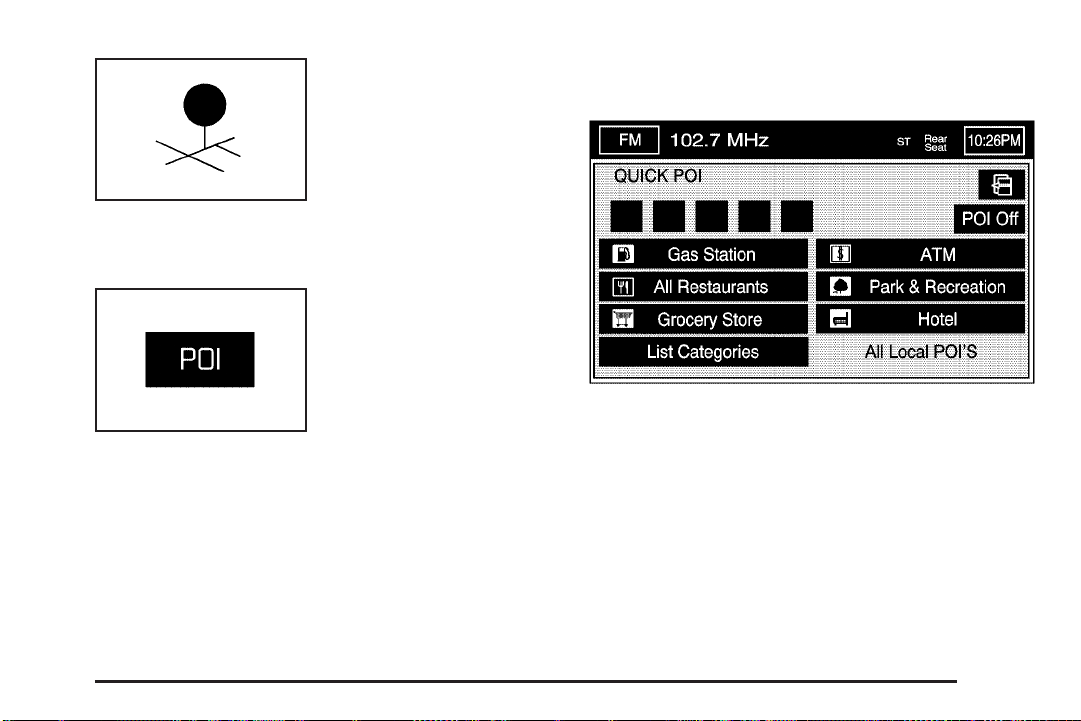
Select the POI screen button to display the
following screen:
2-11
Page 20
Select one of the categories to display or to delete the
POI icons from the map. If the POI icons are currently
displayed on the map, the icons will be deleted from the
map and vice versa.
POI Off: Select this button to not display all of the
icons on the map.
List Categories: Select this screen button to display
more POI categories that are not part of the POI
categories listed. The following screen will be displayed
after List Categories has been selected. Then, select
the category and sub-category from the list. To display
the POI type on the map, select the POI or select
the Show screen button.
Show: Select this screen button to update the map
screen and the list, once a category has been selected.
Delete: To delete a category, do one of the following:
• To delete the last added POI category, select
the Delete screen button.
• To delete a specific POI category:
1. Select the category.
2. Select the subcategory that was added.
All Local POI’s: Select this screen button to display
the list of available POIs. This list is based on the added
POI categories. The list will contain the POIs within a
20 mile (32 km) area from the current position of
your vehicle. The list provides the POI icon, the name,
the direction, and the distance to the POI from your
vehicles current position. Use the scroll symbols to move
up and down the list. Use the Sort by DIST., Icon,
Name, and Route as desired.
2-12
Page 21
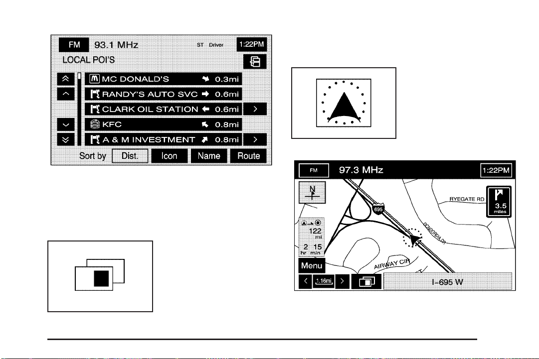
Once a POI icon has been selected, the scroll symbol
will appear around the POI icon on the map and
the name of the POI will appear on the display.
Select the Info screen button to display more available
information about the specific point.
Select the guidance
window symbol, from the
map, to display the
guidance window options.
Select from one of the following six options that allow
you different views and information of the map screen.
Availability of these options depends on the current route.
Select the map view
symbol to display more of
the map with a window
that gives the direction and
distance to the upcoming
maneuver.
2-13
Page 22
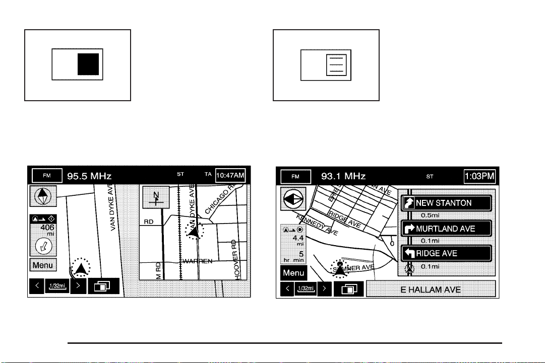
Select the dual view symbol
to display two map screens
that will allow different
scale levels and heading
directions for each.
Select the turn list symbol
to display the next three
upcoming maneuvers.
Touch anywhere inside the right map to change the
scale level, 2D and 3D view, and to turn the POIs
on and off. To change the heading direction in the
right map, touch the north up or heading up symbol.
2-14
Directional arrows, street name, and distance to the
next turn will be displayed. As you approach the
next turn, the system will automatically display a
zoomed-in view of the upcoming maneuver.
Page 23
Select the arrow guidance
symbol to display the
next turn.
Select the next maneuver
symbol to display only the
next maneuver.
A directional arrow, the street name, and the distance to
the next turn will be displayed. As you approach the
next turn, the system will automatically display a
zoomed-in view of the upcoming maneuver.
When approaching the next maneuver, the navigation
system will automatically display this guidance window.
2-15
Page 24
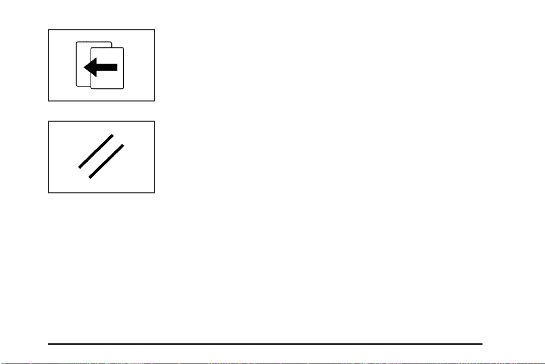
Select the highway
guidance symbol to display
the upcoming exit
number, distance to the
exit, available POIs at the
exit, and a window with
direction and distance
to the next maneuver.
You can use the up and down arrows to scroll through the
displayed list. To view the available POIs for an exit,
select the exit, then select the Map screen button. The
navigation system will display highway guidance any time
you have a route on a highway or freeway or you can
select the symbol. To turn this feature off, see “Navigation
Set Up” under Configure Menu on page 2-55.
2-16
Page 25
Select the back screen
button to return to the
previous page.
Select the cancel screen
button to return to the
first menu of the
selected option.
Auto Reroute
When your destination is set and you are off the
planned route, the system will automatically plan a new
route and begin to reroute. You will be able to see
the new route highlighted on the screen.
Traveling Across Regions
If you plan to drive across many states, you may have
to change the region selected to represent the area
you are traveling to. To do so, do one of the following:
• Change the selected region in the search area
when you get closer to the area you are traveling to.
See Destination on page 2-37 or,
• Change the selected region in the search area
when entering your destination and route settings.
See Destination on page 2-37.
For example, if you were traveling from Michigan to
Florida, change the region currently selected in
the search area to Florida. Enter a destination in
Florida under the DESTINATION ENTRY menu.
2-17
Page 26
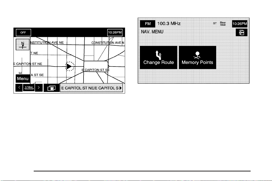
Navigation Menu
Select the Menu screen button to access the NAV.
(Navigation) MENU.
From the NAV. MENU, you can select Change Route or
Memory Points.
2-18
Page 27
Change Route
Selecting Change Route will take you to the ROUTE
OPTIONS menu. The availability of these buttons
depends on if a route is planned or if you are driving a
route. You can perform the following functions from
this menu:
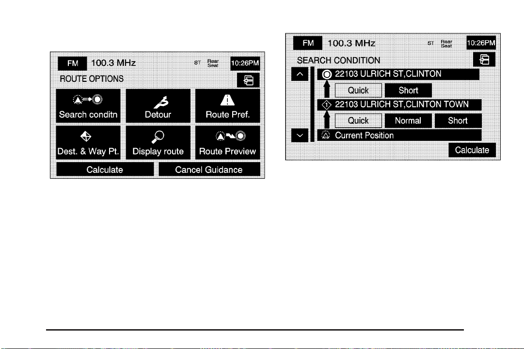
H Search Conditn (Search Condition)
This option will take you to the SEARCH CONDITION
screen.
The search condition screen allows you to view your
current destination and also change the planning
methods between each destination. Use the up/down
arrows to scroll through your routes. Use the available
route preference options to change your planning
method. Touch Calculate to plan the route.
2-19
Page 28
% Detour
From this screen, you can choose to detour 1 mile,
3 miles, or 5 miles around a the current route. You may
also choose to detour the whole route if necessary.
This option is only available while you are driving
on your current planned route.
F Route Pref. (Route Preferences)
This feature will take you to the ROUTE
PREFERENCES screen.
Touch any of the following options to turn them on and
off. The system will use the selected settings to plan
the route. Your selected route preference settings
will appear when planning a route.
2-20
Page 29
c (Allow Major Roads): This feature allows the
system to use major roads when calculating a route.
l (Allow Time Restricted Road): This feature allows
the system to use time restricted roads when
calculating a route.
W (Allow Toll Road): This feature allows the system
to use toll roads when calculating a route.
b (Allow Ferry): This feature allows the system to
use ferries when calculating a route.
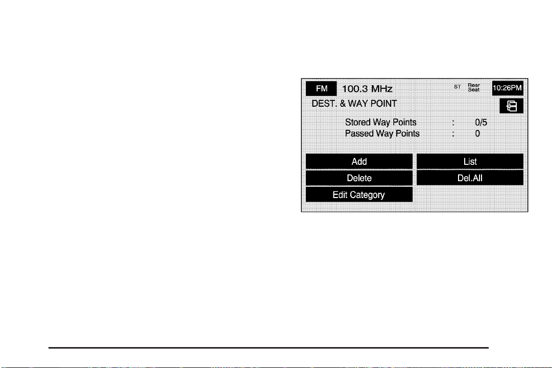
o Dest. & Way Pt. (Destination and Way Point)
From this screen, you can choose to add or delete a
way point from your current route.
Calculate/
calculate the route if a destination has been inputted.
W (Back): Select either screen button to
Select this button to plan a destination with way points.
Five way points and one destination can be entered.
See Dest. & Way Pt. under “Memory Points” later in this
section for more information.
2-21
Page 30
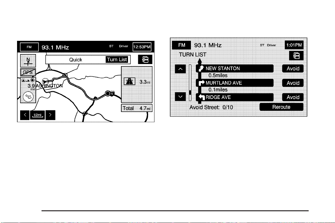
9 Display route
From this screen, you can view the entire route.
Turn List: Select this screen button to view the list of
upcoming maneuvers for the entire route.
y / z (Scroll Arrows): Select the up and down
arrow screen buttons to scroll through the list of
maneuvers.
Avoid: Select this screen button to avoid a maneuver.
Select the Avoid screen button that is next to the
maneuver that you would like to avoid.
2-22
Reroute/
calculate the route based on the selected avoided
maneuvers.
W (Back): Select either screen button to
Page 31

G Route Preview
From this screen, you can preview the entire route in
either direction, as well as edit the route.
Use the touch-sensitive screen buttons at the bottom of
the navigation screen to move forward or backward
through the route.
s (Skip to Start): Select this screen button to skip to
the starting position, previous way point or previous
POI depending on the mode selected.
S / { (Scroll to Start): Select this screen button to
scroll to the starting position, previous way point or
previous POI depending on the mode selected.
This button will toggle between slow and fast speed.
j (Pause): Select this screen button to pause
the route preview.
Th / | h (Scroll to Destination): Select this
screen button to scroll to the destination, next way point
or next POI depending on the mode selected. This
button will toggle between slow and fast speed.
th (Skip to Destination): Select this screen button
to skip to the destination, next way point or next
POI depending on the mode selected.
2-23
Page 32

Edit: Select this screen button to edit the route and to
access the following screen:
To next POI: Select this screen button to view the
available POI icons on the current route.
Delete: Select this screen button to delete the
selected POI.
Select one of the categories, to select a new POI
category that will replace a current POI category.
Memory Points
Selecting Memory Points from the NAV. MENU will take
you to the STORED LOCATIONS screen. From the
STORED LOCATIONS screen, you can access
the following options:
2-24
Page 33

N Memory Points
This feature allows you the ability to store memory
points. You can store them in the four different
categories listed. Once in a folder/category you can
store a point, edit a point, delete a point, delete
all points, or edit a category name. You can store up to
60 memory points per driver.
To store a point:
1. Select the Memory Points screen button from the
STORED LOCATIONS screen.
2. Select one of the folders/categories listed.
3. Select Add.
4. Select the desired method of entering a destination
to enter the memory point. See Destination on
page 2-37 for more information. A map screen will
appear displaying the selected memory point
location.
5. If available, touch the INFO button to view the
address information of the selected point.
6. Touch OK to store the point as a memory point.
2-25
Page 34

To edit the name of a stored point:
1. Select the Memory Points screen button from the
STORED LOCATIONS screen.
2. Select one of the folders/categories listed.
3. Select the Edit screen button.
4. Select the memory point from the list.
Use the Dist. (distance), Icon, Name, and Date
screen buttons to change the sort methods.
5. Select the Name screen button.
6. Use the backspace screen button to delete the
current name or use the alpha keypad to make
changes.
7. Select the OK screen button to store the change.
To move the memory point from one folder/category
to another:
1. Select the Memory Points screen button from the
STORED LOCATIONS screen.
2. Select one of the folders/categories listed.
3. Select the Edit screen button.
4. Select the memory point that you wish to edit.
2-26
Page 35

5. Select the Category screen button.
6. Select the new folder/category button you want to
move the memory point to.
7. The system will display a message confirming
the move.
To store the point as a name tag:
1. Select the Memory Points screen button from the
STORED LOCATIONS screen.
2. Select one of the folders/categories listed.
3. Select the Edit screen button.
4. Select the memory point that you wish to edit.
5. Select the Add Nametag screen button.
6. The system will say “Name please.” State what you
would like to call the memory point.
If the name is short, wait a few seconds to state
the name.
7. The system will play back what was recorded and
then will ask you to confirm the nametag. State
“Yes“ to confirm the nametag; state “No” to cancel
the nametag and to try again.
You can choose whether or not to have the name show
on the map screen, next to the POI icon, by selecting
the Show Name On or Off screen buttons.
Del Nametag (Delete): Once a nametag has been
added, the Add Nametag screen button will change to
Del Nametag.
To delete a name tag, press the Del Nametag screen
button. The nametag will be automatically deleted
from that memory point.
To modify the position of the stored point:
1. Select the Memory Points screen button from the
STORED LOCATIONS screen.
2. Select one of the folders/categories listed.
3. Select the Edit screen button.
4. Select the memory point from the list.
5. Select the Position screen button.
6. The system will display the map screen with the
destination marked. Touch the position on the
map, to move the memory point to that location.
7. Select the OK screen button when the memory
point has been moved to the appropriate location.
8. The system will return to the EDIT MEMORY POINT
screen and will now display the new address,
longitude, and latitude for the memory point.
2-27
Page 36

To change the icon associated with a memory point:
1. Select the Memory Points screen button from
the STORED LOCATIONS screen.
2. Select one of the folders/categories listed.
3. Select the Edit screen button.
4. Select the memory point from the list.
5. Select the Icon screen button.
6. Select the desired icon. There are two pages of
icons and a page of icons that have sounds
associated with them.
7. The new icon will be displayed in the EDIT
MEMORY POINT screen, next to the Icon screen
button on the map.
To change the phone number of a memory point:
1. Select the Memory Points screen button from the
STORED LOCATIONS screen.
2. Select one of the folders/categories listed.
3. Select the Edit screen button.
4. Select the memory point from the list.
5. Select the Tel. screen button.
6. Use the numeric keypad to change the phone
number.
7. Select the OK screen button to store the changed
phone number.
To delete a memory point:
1. Select the Memory Points screen button from the
STORED LOCATIONS screen.
2. Select one of the folders/categories listed.
3. Select the Delete screen button.
4. Select the memory point from the list. Use the sort
feature to sort by distance, icon, name, or date
as needed.
5. The system will show the map screen with the
position address and a pop-up confirmation
message. Select Yes to delete the point; select No
to not delete the point and to return to the
STORED LOCATIONS screen.
2-28
Page 37

To delete all of the memory points in a folder/category:
1. Select the Memory Points screen button from
the STORED LOCATIONS screen.
2. Select the desired folder/category from the
MEMORY POINTS screen.
3. Select the Del.All screen button.
4. The system will display a pop-up confirmation
message. Select Yes to delete all the points in
the folder/category; select No to not delete
the points and to return to the DELETE POINTS
screen.
To change the name of the folder/category:
1. Select the Memory Points screen button from the
STORED LOCATIONS screen.
2. Select one of the folders/categories listed.
3. Select the Edit Category screen button.
4. Use the
displayed name.
5. Use the alpha keypad to input the name of the
folder/category.
6. Select the OK screen button to save your changes.
q backspace screen button to delete the
2-29
Page 38

3 Avoid Area
This feature allows you to store or delete an area to be
avoided, while on a planned route. You can have up
to 10 points stored.
To store a point to be avoided:
1. Select the Avoid Area screen button from the
STORED LOCATIONS screen.
2. Select the Add screen button.
3. Select the desired method of entering a destination
to enter the area to be avoided. See Destination on
page 2-37 for more information. A map screen
will appear displaying the selected location.
4. If desired, reduce or enlarge the area around the
point you want to avoid by using the reduce or
enlarge keys.
5. Select the OK screen button to store the area.
To edit the name of the point to be avoided:
1. Select the Avoid Area screen button from the
STORED LOCATIONS screen.
2. Select the Edit screen button.
3. Select the point to be changed from the list.
4. Select the Name screen button.
5. Use the alpha keypad to add or to change the name.
2-30
Page 39

6. Select the OK screen button to save your changes.
You can choose whether or not to have the name
show on the map screen, next to the avoided
area, by selecting the Show Name On or Off
screen buttons.
To edit the position of the point to be avoided:
1. Select the Avoid Area screen button from the
STORED LOCATIONS screen.
2. Select the Edit screen button.
3. Select the point to be changed from the list.
4. Select the Position screen button.
5. Select the map to move the location.
6. If desired, reduce or enlarge the area around the
point you want to avoid by using the reduce or
enlarge keys.
7. Select the OK screen button to store the area.
To delete a point to be avoided:
1. Select the Avoid Area screen button from the
STORED LOCATIONS screen.
2. Select the Delete screen button.
3. Select the point you want to delete. Use the
scrolling arrows as needed.
4. The system will display the map screen with the
name of the point and a pop-up confirmation
message. Select Yes to have the point deleted;
select No to not delete the point.
To delete all of the points to be avoided:
1. Select the Avoid Area screen button from the
STORED LOCATIONS screen.
2. Select the Del.All screen button.
3. The system will display a pop-up confirmation
message. Select Yes to have all of the points
deleted; select No to not delete the points and to
return to the AVOID AREA screen.
2-31
Page 40

$ Dest. & Way Pt. (Destination and Way Point)
This feature allows you to store, up to five way points,
to the current route.
From this screen you can add, edit, or delete way points
to your route.
To add a way point:
1. Select the Dest. & Way Point screen button from
the STORED LOCATIONS screen.
2. Select the Add screen button.
3. Using the desired method of entering a destination,
enter the way point. See Destination on page 2-37
for more information.
A map screen will appear with the way point marked.
4. Select the o (Way point) symbol on the map screen
to save the way point.
5. Repeat Steps 2 - 4 to add up to five way points to
your route. For the second through the fifth way
points, the system will display the ADD WAYPOINT
screen.
2-32
Page 41

6. Select the desired location/order that you want your
newly added way point to fall in your route by
selecting the corresponding Add screen button.
The Add and arrow screen buttons are located to
show where the new way point is placed.
To change the order of the route:
1. Select the Dest. & Way Point screen button from
the STORED LOCATIONS screen.
2. Select the Edit screen button.
3. From the CHANGE ORDER screen, select the
addresses in the order you would like them to
fall on the route.
4. Select the OK screen button to save your changes.
To change the location of a way point:
1. Select the Dest. & Way Point screen button from
the STORED LOCATIONS screen.
2. Select the Edit screen button.
3. Select the Chg. Loc. screen button from the
CHANGE ORDER screen.
4. From the CHANGE LOCATION screen, select the
point whose location needs to change.
5. The system will display the map screen with the
destination marked. Touch the position on the
map, to move the way point to that location.
6. Select the OK screen button to save your changes.
The system will return to the STORED LOCATIONS
screen.
To delete a way point from your current route:
1. Select the Dest. & Way Point screen button from
the STORED LOCATIONS screen.
2. Select the Delete screen button.
3. Select the way point/destination you want to delete.
4. The system will display the map screen with a
pop-up confirmation message. Select Yes to
delete the way point; select No to not delete the
way point.
2-33
Page 42

To delete all of the way points on your route:
1. Select the Dest. & Way Point screen button from
the STORED LOCATIONS screen.
2. Select the Del.All screen button.
3. The system will display the map screen with a
pop-up confirmation message. Select Yes to
delete the way point; select No to not delete the
way points.
L Home
This feature allows you to add, delete, or edit a point to
be stored as your home destination.
To store your home destination:
1. Select the
STORED LOCATIONS screen.
2. Select the Add screen button.
3. Select a destination entry method. See Destination
on page 2-37 for more information.
4. Select the OK screen button to store the destination.
The home icon will now be highlighted on the
DESTINATION ENTRY screen.
To edit your home destination:
1. Select the
STORED LOCATIONS screen.
2. Select the Edit screen button.
3. Touch the map to move the location of the point.
4. Select the OK screen button to save your changes.
To delete your home point:
1. Select the
STORED LOCATIONS screen.
2. Select the Delete screen button.
3. The system will display the map screen with a
pop-up confirmation message. Select Yes to
delete the home point; select No to not delete the
home point.
L Home screen button from the
L Home screen button from the
L Home screen button from the
2-34
Page 43

& Previous Dest. (Destination)
This feature allows you to delete one or all previous
destinations that have been previously inputted
and automatically stored.
To delete a specific destination:
1. Select the Previous Dest. screen button from the
STORED LOCATIONS screen.
2. Select the Delete screen button.
3. Select a destination from the list.
4. The system will display the map screen with a
pop-up confirmation message. Select Yes to
delete the destination; select No to not delete the
destination.
To delete all destinations:
1. Select the Previous Dest. screen button from the
STORED LOCATIONS screen.
2. Select the Del.All screen button.
3. The system will display the map screen with a
pop-up confirmation message. Select Yes to
delete all of the destinations; select No to not delete
all of the destinations.
A Preset Dests. (Destinations)
This feature allows you to add, delete, or change one of
five preset destinations.
To store a preset destination:
1. Select the Preset Dests. screen button from the
STORED LOCATIONS screen.
2. Select the Add screen button to add a preset
destination.
3. Select the numbered preset icon you would like it to
appear as.
4. Select a destination entry method. See Destination
on page 2-37 for more information.
5. Select the OK screen button to store the destination.
The destination will now be highlighted on the
DESTINATION ENTRY screen.
2-35
Page 44

To edit the name of a preset destination:
1. Select the Preset Dests. screen button from the
STORED LOCATIONS screen.
2. Select the Edit screen button.
3. Select the numbered preset destination name you
want to edit.
4. Select the Name screen button and use the alpha
keypad to edit or add the name.
5. Select the OK screen button to save your changes.
You can choose whether or not to have the name
show on the map screen, next to the preset
destination symbol, by selecting the Show Name
On or Off screen buttons.
To change the position of a preset destination:
1. Select the Preset Dests. screen button from the
STORED LOCATIONS screen.
2. Select the Edit screen button.
3. Select the preset destination you want to change.
4. Select the Position screen button.
5. Touch the position on the map, to move the
destination to that location.
6. Select the OK screen button to save your changes.
2-36
Page 45

To add or change the phone number of a preset
destination:
1. Select the Preset Dests. screen button from the
STORED LOCATIONS screen.
2. Select the Edit screen button.
3. Select the preset destination phone number you
want to change.
4. Select the Tel. screen button and use the numeric
keypad to input or change the phone number.
5. Select the OK screen button to save your changes.
®
If you have a Bluetooth
touch the
the system will call that number.
Display Memory Pt. Icons: Select this screen button,
from the STORED LOCATIONS screen, to display
memory point icons on the map screen. When
highlighted, the feature is on. When dark, the
feature is off.
Calculate: Select this screen button, from the STORED
LOCATIONS screen, to calculate your route.
V (Send/End Call) screen button and
phone connected, you can
Destination
Press the ROUTE key to access the Destination Entry
screen. From this screen, you can choose from several
options to plan a route by entering destination points.
The DESTINATION ENTRY screen allows you to also
select the area included in the search for your
destination. A map of the United States and a part of
Canada divided into 11 regions is shown.
Before selecting a method of destination entry, review
the search area map to make sure your destination
is located in the highlighted region.
2-37
Page 46

If you need to see a list of states included in the
highlighted region, or to change the region, touch
REGION from the DESTINATION ENTRY screen. The
SEARCH AREA screen will be displayed. Touch the
numbered screen button to the right of the search area
map that corresponds with the numbered region you
wish to choose or to view a list of states included in the
region selected. You may also touch the down arrow
to the right of the search area map to choose CAN for
Canada. Once your selection has been made, you
will see the area covered on the map highlighted.
Touch the back key to return to the DESTINATION
ENTRY screen. The new selection will be stored once
you select the back touch screen key.
To enter a destination, choose from one of the following
destination entry methods:
Address
The address destination entry method allows you to
input an address by providing the system with a house
number, street name, and city.
C (Address): Touch this screen button to access the
ADDRESS screen. At this point you can choose to
enter the address one of three ways, either house
number first, street first or city first.
2-38
Page 47

To use the house number first destination entry method,
do the following:
1. Touch the numeric keypad to input the house
number.
2. Touch the Street button to enter the street name
using the alpha keypad.
3. A list of available street names will be displayed if
there are less than 5 items available. You may
select the list screen button at any time to view the
available list. Select the correct street with the
correct prefix from the list.
4. The Navigation System will either display a list of
available cities or go to the map screen directly
based on the input.
5. Select the desired city name on the list.
A map screen will then appear with the destination
marked.
To use the street name first destination entry method,
do the following:
1. Select the Street screen button from the address
menu and start inputting the street name using the
alpha keypad. A list of available street names
will be displayed if there are less than 5 items
available. You may select the list screen button at
any time to view the available list.
2. Select the desired street name with the correct
prefix from the list (Dr., Ln., St., etc.).
3. The Navigation System will display a list of available
cities. Select the correct city from the list.
4. The numeric keypad will be displayed, allowing you
to enter the house number.
5. Press OK.
A map screen will then appear with the destination
marked.
To use the city name first destination entry method,
do the following:
1. Touch the City button.
2. Select from the choices shown on the City screen,
Any City, 5 Nearest Cities, Input City Name, or from
the Last 5 Cities used.
Using the Any City choice will take you back to the
house number first entry method.
Using the 5 Nearest Cities choice, the system will
display the 5 cities nearest your current position.
Using the Input City Name choice will allow you to
input the city name with the alpha keypad.
Using the Last 5 Cities choice, the system will
display a list of the last five city names used.
2-39
Page 48

3. If using the alpha keypad, finish inputting the city
name and then touch the list touch screen button
to display a list of available cities. Choose a
city from the list. If choosing from one of the prior
mentioned lists, select the city from the list
displayed.
4. The House number screen will be displayed. Input
the house number using the numeric keypad.
5. Select the Street screen button from the address
menu and start inputting the street name using the
alpha keypad. A list of available street names
will be displayed if there are less than 5 items
available. You may select the list screen button at
any time to view the available list.
6. Select the desired street name with the correct
prefix (Dr., Ln, St., etc.) from the list
A map screen will then appear with the destination
marked.
See “Getting Started on Your Route” later in this section
for more information.
Point of Interest (POI)
The Point of Interest (POI) destination entry method
allows you to choose a destination from the POI list.
i (Point of Interest): Touch this screen button to
access the POINT OF INTEREST screen. From this
screen you have three options to select/input your
destination. You can either input the name using the
alpha keypad, select a category from the category list
or select the city by touching the city name and
then using the alpha keypad.
2-40
Page 49

To use the point of interest destination entry method by
inputting the name, do the following:
1. Use the alpha keypad to enter the POI name.
Touch Sym. to view a list of symbols to add
when entering a POI, touch Others to view a list
of special characters you can choose from, or touch
A - Z to return to the alpha keypad.
2. A list of POIs will appear if there are fewer than
five POIs found using the information from the
alpha keypad input. You may also touch the
List button at any time to view available POIs.
3. Select the desired POI from the list.
A map screen will then appear with the destination
marked.
To use the point of interest destination entry method by
selecting a category, do the following:
1. Touch the Category screen button from the POINT
OF INTEREST screen to view a list of POI
categories.
2. Choose a category, and then a sub-category.
3. The Navigation System will display available POIs
names in the selected sub-category or if the list is
too long the system will display the alpha keypad.
4. If the alpha keypad is displayed, input the POI
name until a list of available POIs appears.
You may also select the List screen button when it
becomes available.
5. Select the POI from the list.
A map screen will then appear with the destination
marked.
To use the point of interest destination entry method by
selecting a city, do the following:
1. Select the city screen button, then choose from
Any City, 5 Nearest Cities, Input City Name or
from the Last 5 Cities list. If you choose Any City,
the system will return to the name POI input
method/screen. If you choose 5 Nearest Cities,
the system will generate a list of the five nearest
cities to your current position. Or you can select
from the last five cities that were used. If you
choose to input the city name the system will display
the alpha keypad.
2. Input the city name using the alpha keypad.
3. Select the desired city from the list displayed.
4. Use the alpha keypad to enter the POI name.
Touch Sym. to view a list of symbols to add
when entering a POI, touch Others to view a list of
special characters you can choose from, or
touch A - Z to return to the alpha keypad.
2-41
Page 50

5. A list of POIs will appear if there are fewer than five
POIs found using the information from the alpha
keypad input. You may also touch the List button at
any time to view available POIs.
6. Select the desired POI from the list.
A map screen will then appear with the destination
marked.
See “Getting Started on Your Route” later in this section
for more information.
Map
The map destination entry method allows you to choose
a destination by scrolling on the map.
I (Map): Touch this screen button to enter the map
destination entry method.
To use the map destination entry method, do the
following:
1. Touch the map for the desired area you wish to set
as your destination.
2. Use the zoom in/out function to view the direction of
the desired area.
3. Pressing/holding and dragging on the map will
activate fast scrolling. Press/touch once on the
area to which you would like to move the current
position mark.
4. On the map screen you will see the destination
marked. Touch the destination screen button or
the way point screen button to save the address as
a destination or way point.
See “Getting Started on Your Route” later in this section
for more information.
2-42
Page 51

Intersection
The intersection destination entry method allows you to
set two intersecting streets as your destination.
M (Intersection): Touch this screen button to access
the INTERSECTION screen.
To use the intersection destination entry method, do the
following:
1. Enter the first of two streets in the intersection.
The List option may become available.
2. You may now choose a street from the list, or
continue to spell the street name to further
reduce the number of available items. Select the
street with the correct prefix (Dr., Ln., St., etc.).
3. After the first street has been chosen, enter the
second street name. The List option may again
become available.
4. You may now choose the second street from the
list, or continue to spell the street name to further
reduce the number of available items. Select
the street with the correct prefix (Dr., Ln., St., etc.).
After both streets have been chosen, a map
screen will then appear with the destination marked.
See “Getting Started on Your Route” later in this section
for more information.
2-43
Page 52

Phone Number
The phone number destination entry method allows you
to choose a destination by entering a phone number.
The phone number must be in the list of POIs, that
is contained on the map DVD, in order for the system to
retrieve the destination.
U (Phone Number): Touch this screen button to
access the PHONE NUMBER screen.
To use the phone number destination entry method,
do the following:
1. Input the area code and phone number of a POI
using the numeric keypad.
2. If the phone number can be found on the map
DVD, a map screen will then appear with the
destination marked.
See “Getting Started on Your Route” later in this section
for more information.
2-44
Page 53

Freeway Entrance/Exit
The freeway entrance/exit destination entry method
allows you to choose a destination by entering a freeway
entrance or exit point.
K (Freeway Entrance/Exit): Touch this screen button
to access the FREEWAY ENT/EXIT screen.
To use the freeway entrance/exit destination entry
method, do the following:
1. Touch the Freeway screen button and enter the
freeway name. Be sure to use abbreviations,
such as I - 75, rather than spelling out Interstate.
Touch Sym. to view a list of symbols to add
when entering a freeway name, touch Others to
view a list of special characters you can choose
from, or touch A - Z to return to the alpha keypad.
A list of freeways will appear.
2. Choose a freeway from the list, and then touch the
Entrance or Exit screen button to choose a point.
You can choose an exit/entrance point from the list
of names that will appear.
You can input the exit/entrance by name. Touch the
Input Name screen button. If you choose to input
the freeway name, the alpha keypad will be
displayed. Touch the alpha keypad to enter the
freeway exit or entrance name.
You can sort the list by distance or name. Touch
the Name Sort screen button to sort the list by
name. Touch the Dist. Sort screen button to have
the list sorted by distance. The distance sort
list is based on the current position of your vehicle.
After choosing a point from the list, a map screen
will then appear with the destination marked.
See “Getting Started on Your Route” later in this section
for more information.
2-45
Page 54

Emergency
The emergency destination entry method allows you to
enter a destination by choosing from three categories.
| (Emergency): Touch this screen button to access
the EMERGENCY screen. When in this screen, the
system will display your current position address and the
longitude and latitude information.
To use the emergency destination entry method, when
no route has been planned, do the following:
1. Select a category.
2. Select a destination point from the list. Touch the
Name Sort screen button to sort the list by name,
or Dist Sort to sort the list by distance from the
vehicle’s current position.
After selecting a destination from the list, a map
screen will then appear with the destination marked.
To use the emergency destination entry method, when
a route has been planned, do the following:
1. Select a category.
2. The system will automatically change the current
planned route destination to include the nearest
emergency category that has been selected.
See “Getting Started on Your Route” later in this section
for more information.
2-46
Page 55

Memory Points
The memory points destination entry method allows you
to choose a destination from a list of points that you
have previously stored.
Select this screen button
to access the MEMORY
POINTS screen.
To use the memory point destination entry method,
do the following:
1. Select the category/folder in which the memory
point has been stored. Choose from Personal,
Business, Entertainment, or Marked Point folders.
2. Select the desired memory point within the selected
category/folder.
Use the sort button to sort the destinations within
their category/folder. Touch the Dist. screen
button to sort the destination by distance based on
your current position. Touch the Icon screen
button to sort the destinations based on the icon
symbol. Touch the Date screen button to sort
the destinations based on the date they were stored.
Touch the Name screen button to sort the
destinations in alpha/numeric order.
See “Getting Started on Your Route” later in this section
for more information.
2-47
Page 56

Previous Destination
The previous destination entry method allows you to
choose a destination from a list of previous destination
points.
h (Previous Destination): Touch this screen button to
access the PREVIOUS DEST. screen. The system
will store up to 100 points that have been previously
input. As new destinations are entered, the system will
automatically delete the oldest destinations and add
the new destination.
To use the previous destination entry method, do the
following:
1. Choose a previous destination from the list. Use the
arrow to the right of the destination to view the
entire destination name as necessary.
2. After choosing a destination from the previous
destinations list, a map screen will appear with
the destination marked.
Name: Touch this screen button to sort the list by name.
Date: Touch this screen button to sort the list by the
date the destination has been entered. The list will be in
order by the latest to the oldest destinations that have
been entered.
Previous Start Point: Touch this screen button for the
system to plan a route to the previous point you
were at when a route was entered. This option is
available while the vehicle is moving.
See “Getting Started on Your Route” later in this section
for more information.
2-48
Page 57

Coordinates
The coordinates destination entry method allows you to
choose a destination by entering latitude and longitude
coordinates.
) (Coordinates): Touch this screen button to access
the COORDINATES screen.
To use the coordinates destination entry method, do the
following:
1. Touch N or S next to LAT. to enter the direction of
the latitude coordinate.
2. Input the numeric portion of the latitude coordinate
using the keypad.
3. Touch E or W next to LONG. to enter the direction
of the longitude coordinate.
4. Input the numeric portion of the longitude coordinate
using the keypad.
5. Once both coordinates are entered, touch the OK
screen button.
A map screen will then appear with the destination
marked.
See “Getting Started on Your Route” later in this section
for more information.
2-49
Page 58

j Preset Destination
The preset destination entry method allows you to set a
destination by choosing from one of five previously
stored destinations. Besides home, these are the only
destinations available to set while the vehicle is
moving or by voice recognition. If a destination is not
set for one of the screen buttons, the button will
be dimmed and will not be available.
To use the preset destination entry method, do the
following:
1. Select the desired preset destination from the
DESTINATION ENTRY screen. The screen
buttons are numbered 1 - 5.
2. The system will then set the stored preset
destination as your current destination.
3. A map screen will then appear with the destination
marked and the number of the preset destination.
See “Getting Started on Your Route” and “Memory
Points” later in this section for more information.
L Home
This feature allows you to plan a route to one previously
stored destination that you have selected as home.
If a home destination is not stored, the home button will
not be available. In addition to preset destinations
one through five, this destination is available to set while
the vehicle is moving or by voice recognition.
To use this destination entry method, do the following:
1. From the DESTINATION ENTRY screen, touch
the home button.
2. The system will then set your stored preset home
destination as the current destination.
3. A map screen will then appear with the destination
marked.
Once your destination entry is complete, regardless of
which method of entry you used, a map screen with the
destination previewed will be displayed. You can
change route preferences, route options, map
appearances, or add a way point at this time. You may
also set the destination without making any further
changes. See “Getting Started on Your Route” following
in this section for more information on your choices
once a destination has been entered.
2-50
Page 59

Getting Started on Your Route
Once you have entered a destination, you can perform
one of the following options:
h (Destination): Touch the destination symbol to set
the entered destination as it is, without further
adjustment.
o (Waypoint): Touch the way point symbol to enter
this point as a way point along the route. See Dest.
& Way Pt. under “Stored Locations” under Navigation
Menu on page 2-18 for more information.
Route Preference: Touch this screen button to access
the Route Preference screen and adjust the route
preferences. The current setting is displayed in the
Route Preference section of the Map screen. See
“Change Route” later in this section for more
information.
If any of these features are turned off, there will be a
diagonal red line through its icon.
2-51
Page 60

Once the route preference has been set, select the
destination symbol and the system will automatically
calculate your route.
Three Routes
To access this screen, touch the 3routes button on the
map screen while planning a destination.
From this screen you can select Guide to start your
route guidance or select 3routes if available to select
between Quick, Normal, or Short route options. You can
also select the Chg. Route screen button to go to the
ROUTE OPTIONS menu and select from the available
options.
2-52
When applicable, the system will calculate up to three
different versions of your current route in three different
colors: Quick, Normal, and Short. The routes are
shown with distance to destination and estimated travel
time. The quickest route may not be the shortest,
and vice versa. When an optional route is selected it is
shown on the map in another color.
Page 61

W (Toll Road): This icon shows the route’s toll road
distance information.
c (Freeway Travel): This icon shows the route’s
freeway distance information.
b (Ferry): This icon shows the route’s ferry distance
information.
{ (Time-Restricted Roads): This icon shows the
route’s time-restricted road information.
Keyless Access System
Touch Info on the three routes screen to access the
INFO FOR 3 ROUTES screen. From this screen,
you can view the following information for the different
planned routes:
G (Estimated Travel Time): This icon shows the
route’s estimated time of travel.
J (Straight-Line Distance): This icon shows the
route’s straight-line distance to destination.
When you start your vehicle, you will see Driver 1 or
Driver 2 displayed on the cluster. If personalization
is turned off in feature programming, a message will not
appear on the cluster. The number on the back of
the transmitter corresponds to driver 1 or driver 2.
The navigation system can store memory points
for driver 1 and 2 individually. See Personalization on
page 5-2 for more information.
2-53
Page 62

OnStar®System
With an active OnStar®subscription with personal
calling, you can make telephone calls from your vehicle,
using the Navigation System screen to enter the
numbers.
Q (OnStar): Touch this screen button to access the
®
OnStar
phone screen. Touch the AUX hard key to
access this button. This screen is not available while
driving.
V (Place/End Call): Touch this screen button to place
your phone call. While in a call this button will be red
and can then be used to end your call.
Tone Send: Touch this screen button send touch tone
data. This button will become available during a
phone call. This function is used when you need to
enter numbers in response to an automated phone
request, such as when check your voice mail or
are asked to choose menu items.
Incoming Call: When receiving an incoming call, a
pop-up message will be shown on the screen with two
place/end call screen buttons, one green and the
other red. Touch the green button to answer the call.
Touch the red button to reject the call.
When using the OnStar
be muted. The volume of an OnStar
adjusted by using the steering wheel controls or the
volume knob on the Navigation System. See “OnStar
System” in the Index of your vehicle’s owner manual
for more information.
®
system, the audio system will
®
call can be
®
2-54
Page 63

Using the OnStar®Screen to Make a
Phone Call
To make a phone call using the OnStar®screen do the
following:
1. Press the AUX hard key.
®
2. Touch the OnStar
3. Enter the phone number using the numeric keypad.
4. Touch the place/end call screen button to place
the phone call.
5. If you need to use the tone send button for checking
voice mail or responding to an automated request,
enter the appropriate number(s) using the keypad
and then touch the tone send button. Once that set
of numbers has been sent, the tone send button
will be dimmed until another set of numbers is input
on the keypad.
6. To end the call, touch the place/end call screen
button. It will be red while you are on the call.
screen button.
Configure Menu
Press the CONFIG hard key to access this menu,
allowing you to adjust several of your system’s features
and preferences.
Bluetooth
E (Bluetooth
Bluetooth
page 6-2 for more information on the Bluetooth
®
®
): Touch this screen button to access the
®
setup screen. See Bluetooth®Phone on
®
system.
2-55
Page 64

Audio
Touch the Audio screen button to access a screen
where several audio features may be turned on and off
and several options are available for adjustment.
The screen buttons next to each option will be
highlighted if chosen to be on. The items on this menu
will depend on which audio source is playing.
Auto Store: Touch this button to turn the Auto Store on
for the current audio source selected. When on, this
button will appear on the main audio screen. This button
is not available when in XM™.
Info (Information): This button is only available when
in FM or XM™. Select this button to turn information
on. The information will change depending on the audio
source is selected. When on, the Info screen button
will be available to select from the audio main menu.
Category: This information will change depending
on what audio source is selected. This button is only
available when you are using the FM or XM™ audio
modes. Touch this button to turn the Category function
on. When on, the button will be available to select
from the audio main menu.
Traffic: This button is only available when you are
using the FM or CD/DVD audio modes. When on, the
Navigation System will search for stations that broadcast
traffic announcements. See Navigation Audio System
on page 3-2 for more information.
2-56
Page 65

Audio Language: Select this button to view a list of
language choices. Select the desired language to
change the spoken language. The list of languages will
depend on the languages supported by the disc.
Subtitle Language: Select this button to view a list of
languages to choose for subtitles. Select the language
desired. The list of languages will depend on the
languages supported by the disc.
Menu Language: Select this button to view a list of
languages to choose for the DVD menu text. The list of
languages will depend on the languages supported
by the disc.
Parental Level: Select this button if you choose to set
up parental protection. Use the keypad to enter the
password. Select from options such as change level and
change password, as necessary.
Navigation Set Up
3 (Navigation Set Up): Touch this screen button to
access the NAVIGATION SET UP screen.
2-57
Page 66

From this menu, several options are available for
adjustment:
8 2D/3D View: This option allows you to change
the view of the map screen and the guidance screen
between a 2-dimensional and 3-dimensional view.
When changing the map to the 3-dimensional view, use
the up/down arrows to change the angle of the map.
Select Default to return to the factory settings.
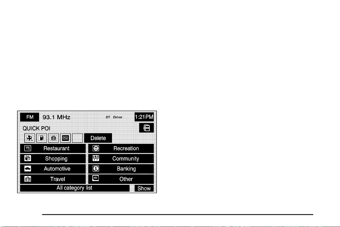
C Quick POI Selection: This option allows you
to set six Point of Interest (POI) categories that you can
select from while driving.
To set the Quick POI selection, do the following:
1. Select the Quick POI Selection screen button.
2. Select the category you would like to replace.
3. Select a Quick POI category from the Quick POI
selection menu list.
4. Pick the subcategory from the list that appears.
The system automatically returns to the Quick
POI Selection screen. Your category changes are
now saved.
To change back to the system generated choices,
touch the Default screen key.
2-58
Page 67

5 Calibration: This option allows you to recalibrate
the navigation system.
Once you enter the Calibration screen, you have the
choice to either adjust your vehicle’s position or to adjust
the vehicle speed signal.
To correct the position of your vehicle on the map
(if your vehicle has been shipped, for example) or to
change to the current position, touch the
Position/Direction screen key.
If there are tire pressure differences or a spare tire is
installed, the Navigation System will automatically
re-calibrate the system but it may take longer.
To calibrate the vehicle speed signal, touch the
Distance screen key.
J User Settings: This option allows you to turn on
and off several other route guidance setting options.
2-59
Page 68

From this screen, you can adjust the following:
Notify traffic restriction: This option instructs the
system to notify you when the current route has traffic
restrictions.
Arrival Time
display the estimated time of arrival to your destination.
Arrival Time
will display how much time remains to reach your
destination.
Guidance Screen: This option will turn the guidance
screen on and off.
Freeway Information: When on, this option will
automatically display freeway information in the
guidance window while on a route. Select the Off screen
button to not display this guidance window.
Text size on map: This option allows you to adjust the
text size on the map between Large, Medium, and
Small. This option is located on the second page of the
USER SETTINGS screen. Touch the down arrow to
access this option.
2-60
G (Time of Arrival): This option will
\ (Time to Destination): This option
\ Restore System Defaults: Select this option
from the NAVIGATION SET UP screen to change
all adjustable system settings to factory defaults.
Page 69

Average Speed: Select this option to set the average
speed to default.
> Volume: This option allows you to adjust the
volume of voice guidance prompts and the voice
recognition system. You may also choose to turn voice
guidance prompts off.
Vehicle
Vehicle: Touch this screen button to access the vehicle
information menu. From this menu, you can adjust
such options as the language, personal settings, and
memory options. See Personalization on page 5-2
for more information on these features.
2-61
Page 70

Clock
H (Clock Adjust): Touch this screen button to access
the Clock Adjust screen and adjust several time features.
From this screen, you can adjust the following:
12Hour: Touch this screen button to display the time in
standard AM/PM format.
24Hour: Touch this screen button to display the time in
military format.
AM: Touch this screen button when setting the time
in AM.
PM: Touch this screen button when setting the time
in PM.
PST, MST, CST, EST: Touch one of these screen
buttons to choose between Pacific Standard Time (PST),
Mountain Standard Time (MST), Central Standard
Time (CST), and Eastern Standard Time (EST).
GPS TIME: Touch this screen button to match the
navigation system’s time to GPS time.
Daylight Savings: Touch this screen button to increase
the time by one hour. Touch this screen button again
to turn this feature off and decrease the time by
one hour.
y/z: Touch the up arrow to increase the hour or
minutes. Touch the down arrow to decrease the hour
or minutes.
2-62
Page 71

Screen Appearance
z (Screen Appearance): Touch this screen button to
access the appearance screen menu.
From this menu, several options may be adjusted:
Color Scheme: This option allows you to choose
between three different screen color schemes by
touching 1 (blue), 2 (green), or 3 (brown).
Color Mode: This option allows you to adjust your
screen mode between Auto, Day, and Night. Day mode
will change the navigation system screen to a lighter
background for better viewing in the daytime. Night
mode will change the navigation system screen
to a darker background for better viewing at night.
Auto mode will adjust the screen automatically
depending on exterior lighting conditions.
_ (Contrast): This feature allows the adjustment of
contrast of the navigation screen. Touch the plus (+)
or minus (−) signs on either side of the contrast
bar graph to increase or decrease the contrast.
] (Brightness): This feature allows the adjustment
of brightness of the navigation screen. Touch the
plus (+) or minus (−) signs on either side of the
brightness bar graph to increase or decrease the
brightness.
Screen OFF: This feature allows you to turn the
navigation screen off. Touch any hard key to turn the
screen back on.
2-63
Page 72

Global Positioning System (GPS)
The Navigation System determines the position of your
vehicle by using satellite signals, various vehicle
signals and map data.
At times, other interferences such as the satellite
condition, road configuration, the condition of the vehicle
and/or other circumstances can interfere with the
Navigation’s ability to determine the accurate position of
the vehicle.
The GPS shows the accurate current position of your
vehicle using signals sent by the GPS Satellites of
the United States Department of Defense. When your
vehicle is not receiving signals from the satellites,
a symbol will appear on the map screen. Refer to
Symbols on page 2-8.
This system may not be available/or interference may
occur if the following happens:
• Signal obstructions caused by tall buildings, large
trucks, tunnels,
• objects located on top of the instrument panel,
• satellites will not send signals if they are being
repaired or improved,
• after-market glass tinting has been applied to the
vehicle’s windows.
Notice: Do not apply after-market glass tinting to
the vehicle’s windows. Glass tinting will interfere
with the system’s ability to receive GPS signals and
cause the system to malfunction. You might have
to replace the window to correct the problem.
This would not be covered by your warranty.
For more information if you are experiencing a problem,
see If the System Needs Service on page 2-66 and
Problems with Route Guidance on page 2-65.
Vehicle Positioning
At times, the position of the vehicle on the map may be
inaccurate due to one or more of the following
reasons:
• The road system has changed.
• The vehicle is driving on slippery road surfaces
such as in sand, gravel and/or snow.
• The vehicle is traveling on winding roads.
• The vehicle is on a long straight road.
• The vehicle is approaching a tall building or a large
vehicle.
• The surface streets run parallel to a freeway.
• The vehicle has just been transferred by a vehicle
carrier or a ferry.
2-64
Page 73

• The current position calibration is set incorrectly.
• The vehicle is traveling at high speed.
• The vehicle changes directions more than once, or
when the vehicle is turning on a turn table in a
parking lot.
• The vehicle is entering and/or exiting a parking lot,
garage or a lot with a roof.
• The GPS signal is not received.
• A roof carrier is installed on your vehicle.
• The vehicle is equipped with tire chains.
• The tires are replaced.
• The tire pressure for your tires is incorrect.
• The tires are worn.
• The first time the map DVD is inserted.
• The battery is disconnected for several days.
• The vehicle is driving in heavy traffic where driving
is at low speeds, and the vehicle is stopped and
started repeatedly.
If you experience problems with your system, you may
need to calibrate the system. This may be due to
tire pressure differences, or if a spare tire is installed.
To calibrate the system, see Configure Menu on
page 2-55.
Problems with Route Guidance
Inappropriate route guidance may occur under one or
more of the following conditions:
• You have not turned onto the road indicated.
• Route guidance may not be available when using
automatic rerouting for the next right or left turn.
• The route may not be changed when using
automatic rerouting.
• There is no route guidance when turning at an
intersection.
• Plural names of places may be announced
occasionally.
• It may take a long time to operate automatic
rerouting during high-speed driving.
• Automatic rerouting may display a route returning to
the set waypoint if you are heading for a destination
without passing through a set waypoint.
• The route prohibits the entry of a vehicle due to a
regulation by time or season or any other regulation
which may be given.
2-65
Page 74

• Some routes may not be searched.
• The route to the destination may not be shown if
there are new roads, if roads have recently
changed or if certain roads are not listed on the
map DVD. See Ordering Map DVDs on page 2-66.
To recalibrate the vehicle’s position on the map,
see Configure Menu on page 2-55.
If the System Needs Service
If your system needs service and you have followed the
steps listed here and still are experiencing problems,
see your dealer for assistance. For more information
on calibrating the system, see Configure Menu on
page 2-55.
Ordering Map DVDs
The map DVD in your vehicle is the most up-to-date
information available when your vehicle was purchased.
The map DVD is updated once a year, provided that
the map information has changed. To order a new map
DVD, contact your dealer.
Database Coverage Explanations
The United States, excluding Alaska and Hawaii, and
portions of Canada are contained on one DVD disc.
The map database contains three different levels
of coverage: detailed areas, non-detailed areas and
limited guidance areas. Detailed areas are available for
the United States and Canada and are primarily
located around metropolitan areas. Limited guidance
areas are only available for the United States. The roads
are displayed on the map, but route and voice
guidance is not available. Non-detailed areas are
available for Canada only. Major roads are included
depending upon available coverage.
For more detailed information on database coverage,
see the Navigation System Map Disc manual included
inside the map DVD case.
2-66
Page 75

Section 3 Navigation Audio System
Navigation Audio System ..................................3-2
Six-Disc CD/DVD Changer .............................3-13
Auxiliary Devices ..........................................3-23
Radio Personalization ....................................3-24
3-1
Page 76

Navigation Audio System
Notice: Before adding any sound equipment to your
vehicle, such as an audio system, CD player, CB
radio, mobile telephone, or two-way radio, make sure
that it can be added by checking with your dealer.
Also, check federal rules covering mobile radio and
telephone units. If sound equipment can be added,
it is very important to do it properly. Added sound
equipment may interfere with the operation of your
vehicle’s engine, radio, or other systems, and even
damage them. Your vehicle’s systems may interfere
with the operation of sound equipment that has
been added.
Your vehicle has a feature called Retained Accessory
Power (RAP). With RAP, the audio system can be played
even after the ignition is turned off. See “Retained
Accessory Power (RAP)” in the Index of your vehicle’s
owner manual for more information.
The audio system is operated using navigation system
menus. The audio menus are explained in this section.
Playing the Radio
On
audio system on and off. Turn the knob to the right
to increase or to the left to decrease the volume to the
audio system.
(Power/Volume): Press this knob to turn the
BAND: Press this key to switch between AM, FM,
WX (weather), or XM, if equipped.
AUX (Auxiliary): Press this key to play the video and
audio devices connected to the auxiliary jacks. See
Auxiliary Devices on page 3-23 for more information.
SRCE (Source): Press this key to change the
audio source from the radio band to CD, audio DVD, or
video DVD, depending on what is loaded in the
six-disc DVD changer, or from DVD/CD to radio mode.
e (Audio): Press this key to view the AUDIO ADJUST
screen. See “Audio Adjust” screen later in this section.
ǻ (Seek/Scan): To seek stations, press the up or
down arrow to go to the next or previous station
and stay there.
To scan stations, press and hold either arrow for less
than 2 seconds. The radio will go to a station, play for a
few seconds, then go on to the next station. To stop
scanning, press either arrow again or touch the
scan screen button.
Tuning Knob: Turn this knob to go to the next or
previous station and stay there.
3-2
Page 77

Finding a Station
Press the source screen button, located in the top left
corner (AM, FM, CD, etc.), from any screen to
access the audio source screen. Once this screen is
displayed, press the BAND hard key to toggle between
the bands or touch the desired band screen button,
to select it.
FM source shown, other sources similar
Scan: To scan stations, touch the Scan screen button.
The radio will go to a station, play for a few seconds,
then go on to the next station. Touch Scan again to
stop scanning.
To scan preset stations, touch and hold Scan for
two seconds. The radio will go to the next preset station,
play for a few seconds, then go on to the next preset
station. Touch Scan again to stop scanning. While in
A.B.C mode, the system will change bands and screens
to the current band.
If available on your vehicle, you can also use the 1 - 6
(preset seek) steering wheel control. Each press of
this button will take you to the next preset station.
Auto Store (Automatic): Select this screen button to
automatically create a preset station list of the strongest
stations available in the local area. Once this button
is selected, the system will start storing stations in
sequential order, starting from the station currently
selected. Select this button again to return to the original
preset stations. This is not available for XM™ Satellite
Radio Stations.
[ ] (No Traffic Announcements): This symbol will
appear on the status line when traffic is selected, but the
station does not broadcast traffic announcements.
[TA] (Traffic Announcements): This symbol will
appear on the status line when the station selected
broadcasts traffic announcements. TA announcements
will depend on the station.
3-3
Page 78

Preset Stations
Storing Preset Stations
This feature allows you to store up to 24 preset stations.
You can store six AM, six FM, six WX (weather), and
six XM™ (if equipped). To store presets, do the
following:
1. Turn the audio system on or select the source
screen button.
2. Select the audio band.
3. Seek, scan, or tune to the desired station.
4. Press and hold one of the six preset screen buttons
for more than two seconds or until you hear a beep.
5. Repeat the steps for each preset.
Storing A.B.C Preset Stations
This feature allows you to store up to 42 presets,
six stations each in seven different lists. The list names
are A - G. Press the left/right arrow buttons to scroll
through the list. The name of the list is displayed
between the two arrows and the presets for each list
are displayed on the preset buttons. These presets are
in addition to any preset stations that may be stored.
To exit this mode, press the A.B.C screen button.
To store the A.B.C presets, do the following:
1. Turn the audio system on or select the source
screen button.
2. Select the A.B.C screen button.
3. Scroll to the desired list (A - G).
4. Select the audio band. The presets within each list
can be mixed: AM, FM, or XM™, if equipped.
5. Seek, scan, or tune to the desired station.
6. Press and hold one of the six preset screen buttons
for more than two seconds or until you hear a beep.
7. Repeat the steps for each preset and list.
3-4
Page 79

Audio Adjust
e
(Audio Adjust): Touch this hard key to access the
AUDIO ADJUST menu and to adjust the tone, Digital
Signal Processing (DSP), fade, and balance for all
sources. The system automatically stores audio
adjustment settings as changes are made to a
preset station.
Audio Pilot: With this feature, your audio system
compensates for unwanted noise in the vehicle.
AudioPilot
that it always sounds the same to you. To use
AudioPilot
®
automatically adjusts the volume level so
®
, touch the Audio Pilot screen button. To turn
it off, touch the screen button again. When this feature
is on, the button will be highlighted. For additional
information on AudioPilot
®
, please visit www.bose.com.
Multi-channel: When available, touch this screen
button to play the DVD Audio source in surround mode.
Touch this screen button again to have the audio
play in 2-channel mode. The system will play Dolby
®
and DTS tracks in surround sound. This feature depends
on the media in the DVD changer.
3-5
Page 80

Setting the Tone
Adjusting the Speakers
P (Treble): Touch the plus (+) or minus (−) sign next to
this symbol to increase or decrease the treble. Touch
the center position to adjust the setting to the center.
Mid (Mid-range): Touch the plus (+) or minus (−) sign
next to this symbol to increase or decrease the
mid-range. Touch the center position to adjust the
setting to the center.
D (Bass): Touch the plus (+) or minus (−) sign next to
this symbol to increase or decrease the bass. Touch
the center position to adjust the setting to the center.
Z (Speaker): Touch the plus (+) or minus (−) sign next
to this symbol to increase or decrease the speaker
when in surround mode or Center Point DSP setting is
selected. This feature allows you to increase or
decrease the amount of surround sound. Touch the
center position to adjust the setting to the center.
Left/Right (Balance): To adjust the balance between
the right and the left speakers, touch and hold the Left or
Right screen buttons. To center the balance and the
fade, touch the center, where the two lines meet.
Front/Rear (Fade): To adjust the fade between the
front and the rear speakers, touch and hold the Front or
Rear screen buttons. To center the balance and the
fade, touch the center, where the two lines meet.
Digital Signal Processing (DSP)
This feature is used to provide a choice of five different
listening experiences. DSP can be used while listening to
the audio system or the six-disc DVD changer. The type
of DSP selected is displayed on the status line.
You may choose from the following DSP settings:
Center Point: Select this screen button to adjust the
audio to get the best sound quality when listening to an
XM™ audio source or CD/DVD. This feature creates
a multi-channel experience from CDs containing stereo
recordings. This feature is not available in AM, FM,
or WX (weather).
3-6
Page 81

Normal: For non-surround sound sources only. Select
this screen button to adjust the audio to be in normal
mode. DSP will be in the off mode.
Driver: For non-surround sound sources only. Select
this screen button to adjust the audio to give the
driver the best possible sound quality.
Talk: For non-surround sound sources only. Select this
screen button when listening to non-musical material
such as news, talk shows, and sports broadcasts.
The Talk DSP setting makes spoken words sound clear.
Rear Seat: For non-surround sound sources only.
Select this screen button to adjust the audio to give the
rear seat occupants the best possible sound quality.
Storing Audio Adjustments to a
Preset Station
To store audio adjustments to a preset station, do the
following:
1. Turn the audio system on or select the source
screen button.
2. Select the band or the A.B.C screen button.
3. Select the preset station.
4. Press the
tone, Digital Signal Processing (DSP), fade, and
balance. The screen will time out and the changes
will be stored.
5. Repeat the steps for each preset.
e (audio adjust) hard key to adjust the
3-7
Page 82

Radio Data System (RDS)
The audio system has a Radio Data System (RDS).
RDS features are available for use only on FM stations
that broadcast RDS information. With RDS, the radio
can do the following:
• Seek to stations broadcasting the selected type of
programming
• Receive announcements concerning local and
national emergencies
• Display messages from radio stations
• Seek to stations with traffic announcements
This system relies on receiving specific information from
these stations and will only work when the information
is available. In rare cases, a radio station may broadcast
incorrect information that will cause the radio features
to work improperly. If this happens, contact the
radio station.
The RDS system is always on. When information is
broadcast from the FM station you are listening to, the
station name or call letters will be displayed on the
audio screen. RDS may provide a program type (PTY)
for current programming and the name of the program
being broadcasted.
Info (Information): Select this screen button to display
information broadcasted by the RDS station when in
FM. This is not available for AM or WX stations.
Category: Select this screen button when in FM to
view the program types. They will appear in place of the
preset stations. Select a category and the system will
start seeking for available stations within the selected
category. If none are found, the system will display
“None Found” and will return to the last selected station.
To seek to another category, press the seek/scan
key. The system will seek to another station in the
category.
To scan stations in the category, press and hold the
seek/scan key. The system will start scanning the
stations in the category. Press the seek/scan key to stop
scanning stations.
To exit out of category, select the category screen
button and the program types will no longer be
displayed.
Each of the six category names displayed, include a
grouping of other program types, see the following table.
This is not available for AM or WX (weather) stations.
3-8
Page 83

Group Name Category
Rock
Classic Rock
POP
EASY
TALK
CNTRY Country Music
CLASS Classical
JAZZ Jazz Music
Adult Hits
Top 40
Oldies Music
Nostalgia
College
Soft Rock
Soft
R&B
Soft R&B
Religious Music
News
Information
Sports
Talk
Language
Religious Talk
Personality
Public
Weather
XM™ Satellite Radio Service
XM™ is a satellite radio service that is based in the
48 contiguous United States. XM™ offers over
100 coast-to-coast channels including music, news,
sports, talk, and children’s programming. XM™ provides
digital quality audio and text information, including
song title and artist name. A service fee is required in
order to receive the XM™ service. For more information,
contact XM™ at www.xmradio.com or call
1-800-852-XMXM (9696).
When XM™ is active, the channel name and number,
song title, and artist will be displayed on the screen.
3-9
Page 84

Info (Information): Select this screen button to display
broadcasted Information. Select Info again to remove
the broadcasted information from the display.
XL (Explicit Language Channels): XL on the radio
display, after the channel name, indicates content with
explicit language. These channels, or any others,
can be blocked at a customer’s request, by calling
1-800-852-XMXM (9696).
Category: Use this feature to listen to channels in a
specific category.
To select a category:
1. Select the XM™ audio source.
2. Select the Category screen button.
The system will display the available categories in
place of the preset stations.
3. Use the left and right arrows to scroll through the
categories. The current category name is displayed
in between the arrows. The category display on
the screen will time out after 6 seconds if you do not
select anything.
4. Select a category and the system will start seeking
for available stations within the selected category.
To view the available channels within the category,
select the category, then use the tune knob or
seek button to scroll through the available channels
within the selected category.
Category Scanning: This function allows you to scan
through the channels in a specific category. To activate
the category scan function, do the following:
1. Select the XM™ audio source.
2. Select the Category screen button.
The system will display the available categories in
place of the preset stations.
3. Use the left and right arrows to scroll through the
categories. The current category name is displayed
in between the arrows. The category display on
the screen will time out after 6 seconds if you do not
select anything.
4. Select the desired category.
5. Select the Scan screen button and the system will
scan through the channels within the selected
category. Select Scan again to stop scanning.
When scanning XM™ channels, scanning will not
stop on Channel 1.
3-10
Page 85

XM Radio Messages
Radio Display Message Condition Action Required
XM Updating Updating encryption code The encryption code in the receiver is being updated and no
No XM signal Loss of signal The system is functioning correctly, but the vehicle is in a
Loading XM Acquiring channel audio
(after 4 second delay)
Channel Off Air Channel not in service This channel is not currently in service. Tune in to another
Channel Unavail Channel no longer
available
No Artist Info Artist Name/Feature not
available
No Title Info Song/Program Title not
available
No CAT Info Category Name not
available
action is required. This process should take no longer than
30 seconds.
location that is blocking the XM™ signal. When you move
into an open area, the signal should return.
The audio system is acquiring and processing audio and
text data. No action is needed. This message should
disappear shortly.
channel.
This previously assigned channel is no longer assigned.
Tune to another station. If this station was one of the
presets, choose another station for that preset button.
No artist information is available at this time on this channel.
The system is working properly.
No song title information is available at this time on this
channel. The system is working properly.
No category information is available at this time on this
channel. The system is working properly.
3-11
Page 86

Radio Display Message Condition Action Required
Not Found No channel available for
the chosen category
No Information No Text/Informational
message available
XM Theftlocked Theft lock active The XM™ receiver in the vehicle may have previously been
XM Radio ID Radio ID label
(channel 0)
Unknown Radio ID not known
(should only be if
hardware failure)
Check XM Receiver Hardware failure If this message does not clear within a short period of time,
There are no channels available for the selected category.
The system is working properly.
No text or informational messages are available at this time
on this channel. The system is working properly.
in another vehicle. For security purposes, XM™ receivers
cannot be swapped between vehicles. If this message is
received after having your vehicle serviced, check with your
GM dealer.
If tuned to channel 0, this message will alternate with the
XM™ Radio eight digit radio ID label. This label is needed
to activate the service.
If this message is received when tuned to channel 0, there
may be a receiver fault. Consult with your GM dealer.
the receiver may have a fault. Consult with your GM dealer.
3-12
Page 87

Six-Disc CD/DVD Changer
This system has the ability to play different types of
media formats. The system can play DVD - Video,
DVD - Video (DTS), DVD - Audio, CD - Digital Audio
(CD - DA), CD-DA (DTS), CD - Text, CD - Extra,
MP3 - CD, CDR, and CDRW. The system may also play
DVD - R and DVD - RW type discs depending on the
writing software used. The system will play DTS
and Dolby
With the six-disc CD/DVD changer, you can play up to
six audio CDs, MP3s, DTS discs, audio DVDs, or
video DVD discs continuously.
®
tracks in surround sound.
M (Load): To load one disc, do the following:
1. Press the load hard key and follow the screen
message displayed.
2. Select the slot number, 1–6, to load the disc into.
If a slot is not selected, the system will load the
first available slot.
3. When the screen displays “Insert Disc (number)”,
insert the disc partway into the slot, label side up.
The system will pull it in and start playing.
The system will display the type of disc inserted,
DVD - Video,
MP3 CDs, or DVD - Audio.
To load multiple discs, do the following:
1. Press and hold the load hard key.
2. When the screen displays “Insert Disc (number)”,
load the disc partway into the slot, label side up.
The system will pull it in.
3. Once a CD is loaded, the system will display
“Insert Disc (number)” again. Load the next disc.
Repeat this procedure for each disc. The player
takes up to six disc(s), do not try to load more than
six. The system will not display the disc types
when loading all, until the discs have been read by
the system.
B Audio for CD/DTS, MP3 for
3-13
Page 88

Once all discs have been inserted, the system will
start playing the last loaded disc.
If no CD or DVD is loaded in the CD/DVD changer
and you press the SRCE hard key a “No disc
loaded” error message will be displayed.
Select the Cancel screen button, when available, to
stop the loading process and to start playing the
last loaded disc.
Z (Eject): To eject a disc, do the following:
1. Press the eject hard key.
2. Select the slot number, 1–6, to eject the disc.
3. The system will display “Ejecting Disc” and then
eject the disc.
If a selection is not made, the system will eject the
disc from the current slot. If the disc is not
removed from the slot, the system will pull it back in
after 10 seconds and start playing it.
To eject all discs at once, press and hold the eject hard
key. The system will display the disc number being
ejected.
Playing an Audio CD
The numbered screen buttons, 1 through 6, represent
the order of the discs loaded in the changer. If there are
only two discs loaded, only screen buttons 1 and 2
will be available.
Play: Select one of the available screen buttons,
1 through 6, to begin playing that disc. There will be a
12 to 15 second delay while the CD is read, before
it begins to play.
3-14
Page 89

Scan: Select the Scan screen button to toggle between
the following scan options:
X (Scan One Disc): Select this screen button to scan
the first 10 seconds of each track on the selected
disc. Select the OFF screen button to stop scanning.
When the system has scanned through all of the tracks,
the system will automatically stop scanning.
M SCAN (Scan All Disc): Select this screen button to
scan the first 10 seconds of each track on each disc.
Select the OFF screen button to stop scanning.
When the system has scanned through all of the discs,
the system will automatically stop scanning. This
function scans all discs with the same type of media.
y (Random): Select the random screen button
to toggle between the following random options:
B RND (Random One Disc): Select this screen
button to hear the tracks on the selected disc, in
random, rather than sequential, order. Select the
OFF screen button to turn off random play.
M RND (Random All Discs): Select this screen button
to hear the tracks on all of the loaded discs, in random,
rather than sequential, order. Select the OFF screen
button to turn off random play. This function will random
all discs with the same type of media.
k (Repeat): Select the repeat screen button to toggle
between the following repeat options:
X (Repeat Track): Select this screen button to repeat
the track you are listening to. Select the OFF screen
button to turn off repeat play.
B RPT (Repeat Disc): Select this screen button to
repeat the disc you are listening to. Select the OFF
screen button to turn off repeat play. This function
repeats all discs with the same type of media.
ǻ(Seek Up/Down): Press the up arrow hard key
to seek to the next track on a disc. If playing the last
track of the disc, pressing the up arrow will seek to the
first track of the next disc. Press the down arrow
hard key twice to seek to the previous track on a disc.
If playing the first track of the disc, pressing the down
arrow will seek to the last track on the selected disc.
OFF: Select this screen button to turn off the scan,
random, or repeat functions.
3-15
Page 90

Playing an MP3 CD
The numbered screen buttons, 1 through 6, represent
the order of the discs loaded in the changer. If there are
only two discs loaded, only screen buttons 1 and 2
will be available to choose from.
r (Play): Select this screen button or press one of the
available screen buttons, 1 through 6, to begin playing
that disc. There will be a 12 to 15 second delay while the
CD is read, before it begins to play.
Scan: Select the Scan screen button to toggle between
the following scan options:
X (Scan One Disc): Select this screen button to scan
the first 10 seconds of each track on the selected
disc. Select the OFF screen button to stop scanning.
When the system has scanned through all of the tracks,
the system will automatically stop scanning.
# SCAN (Scan Folder): Select this screen button to
scan the first 10 seconds of each track, in each
folder, on the selected disc. Select the OFF screen
button to stop scanning. When the system has scanned
through all of the tracks, the system will automatically
stop scanning.
M SCAN (Scan All Discs): Select this screen button
to scan the first 10 seconds of each track on each
disc. Select the OFF screen button to stop scanning.
When the system has scanned through all of the loaded
discs, the system will automatically stop scanning.
This function scans all discs with the same type
of media.
3-16
Page 91

y (Random): This function randoms all discs with the
same type of media. Select the random screen button
to toggle between the following random options:
# RPT (Repeat Folder): Select this screen button to
repeat the folder you are listening to. Select the OFF
screen button to turn off repeat play.
# RND (Random One Folder): Select this screen
button to hear the tracks, in the current folder, on the
selected disc, in random, rather than sequential, order.
Select the OFF screen button to turn off random play.
B RND (Random All Folders): Select this screen
button to hear the tracks, in all folders, on the selected
disc, in random, rather than sequential, order. Select
the OFF screen button to turn off random play.
M RND (Random All Discs): Select this screen
button to hear the tracks, in all folders, on all loaded
discs, in random, rather than sequential, order. Select
the OFF screen button to turn off random play. This
function randoms all discs with the same type of media.
k (Repeat): Select the repeat screen button to
toggle between the following repeat options:
X (Repeat Track): Select this screen button to repeat
the track you are listening to. Select the OFF screen
button to turn off repeat play.
B RPT (Repeat Disc): Select this screen button to
repeat the disc you are listening to. Select the OFF
screen button to turn off repeat play. This function
repeats all discs with the same type of media.
ǻ (Seek Up/Down): Press the up arrow hard key
to seek to the next track on a disc. If playing the
last track of the disc, pressing the up arrow will seek to
the first track of the next disc. Press the down arrow
hard key twice to seek to the previous track on a disc.
If playing the first track of the disc, pressing the down
arrow will seek to the last track on the selected disc.
OFF: Select this screen button to turn off the scan,
random, or repeat functions.
Display: Select this screen button to display the MP3
play list. Use the up/down arrows to scroll through
the list. Select the folder or track to play. While in this
menu, you can use the scan, random, and repeat
functions.
3-17
Page 92

# (Root Directory): Select this screen button to go
to the root directory, if available, on the MP3 disc.
While in this mode, you can select a specific folder to
be played.
HOME: Select this screen button to allow you to go to
the Home folder. This is the first folder on the disc.
# + (Next folder): Select this screen button to go to
the next folder.
# – (Previous folder): Select this screen button to
go to the previous folder.
j (Pause): Select this screen button to pause play.
Select this button again to resume play.
[ (Fast forward): Select this screen button to fast
forward through the current track.
Playing an Audio or Video DVD
Audio DVD screen shown, Video DVD screen similar
r (Reverse): Select this screen button to reverse
through the current track.
Combined Disc: This system will also play a combined
disc which contains CD-DA and MP3 types of media.
Use the CD screen button to switch between MP3 and
CD-DA tracks when you are playing a combined disc.
3-18
Display: Select this screen button to access more
audio/video DVD options.
a (Page Up): Select the page up symbol to scroll up
through the pages of an audio DVD. The function of
this screen button depends on the disc inserted.
Page 93

` (Page Down): Select the page down symbol to
scroll down through the pages of an audio DVD.
The function of this screen button depends on the
disc inserted.
HOME: Select this screen button to take you back to
the home page of the DVD disc.
r / [ (Reverse/Fast Forward): Touch the left or
right arrows to reverse or fast forward within a track.
r (Play): Select the play screen button to begin
playing the currently selected disc.
j (Pause): Select the pause screen button to pause
the currently playing disc. Select this button again
to resume play.
o (Stop): Select the stop screen button to stop
playing the disc.
L (Frame Advance): Select this screen button to play
the disc in slow motion.
Scan: Select the Scan screen button to hear the first
10 seconds of each track on the selected disc.
Select the OFF screen button to stop scanning. When
the system has scanned through all of the tracks,
the system will automatically stop scanning.
M SCAN (Scan All Discs): Select this screen button
to hear the first 10 seconds of each track on all
loaded discs. Select the OFF screen button to stop
scanning. When the system has scanned through all of
the loaded discs, the system will automatically stop
scanning. This function scans all discs with the same
type of media.
y (Random Track): Select this screen button to hear
the tracks on the selected disc, in random, rather
than sequential, order. Select the OFF screen button to
turn off random play.
M RND (Random All Discs): Select this screen
button to hear the tracks on all of the loaded discs, in
random, rather than sequential, order. Select the
OFF screen button to turn off random play. This function
randoms all discs with the same type of media.
k (Repeat): Select this screen button to repeat the
current track. Select this screen button again to
repeat the selected disc. Select this screen button a
third time to repeat all of the loaded discs. This function
repeats all discs with the same type of media. Select
the OFF screen button to turn off repeat play.
X (Repeat DVD): Select this screen button to repeat
the current track. Select the OFF screen button to
turn off repeat play.
3-19
Page 94

OFF: Select this screen button to turn off the scan,
random, and repeat functions.
ǻ(Seek Up/Down): Press the up arrow hard key
to go to the next track in the current group. If you
are in the last track, the system will go to the first track
of the next group. If you are in the last track of the
last group, the system will display an error message in
the upper right corner of the screen.
Press the down arrow hard key to go back to the
beginning of the current track. Press the down arrow
hard key again to go to the previous track in the current
group. If you are in the first track of the current group,
pressing this hard key will take you to the last track
of the previous group. If you are in the first track of the
first group, the system will display an error message
in the upper right corner of the screen.
Cursor: Select this screen button to access the left,
right, up, and down cursors on the screen. The cursors
allow you to navigate through menu options on the
screen.
3-20
Page 95

S, y, T, z (Cursor Arrows): Select these cursor
screen buttons when you need to scroll through a
list of DVD items, such as track names, menu options,
or scene selection. Then touch Enter to set your
selection.
Keypad: Select this button and a number keypad will
appear. Input the track number, press enter, and
the system will play the track.
Menu: Select this screen button to access the DVD’s
menu options. Depending on the type of DVD you
are using, this screen button may or may not be
available.
DVD Menu: Select this screen button to access the
video DVD menu.
While watching a video DVD or playing an audio DVD,
touch anywhere on the screen to remove the DVD
menu for easier viewing. Touch anywhere on the screen
again to display the DVD options.
Audio: Select this screen button to change the audio
language heard. This may not be available on all DVDs.
Depending on the type of DVD playing, this screen
button may or may not be available.
Angle: Select this screen button to adjust the viewing
angle of the DVD. Some DVDs allow you to change the
camera angle. This may not be available on all DVDs.
Depending on the type of DVD playing, this screen
button may or may not be available.
Subtitle: Select this screen button to play back the
video with subtitles. This may not be available on
all DVDs. Depending on the type of DVD playing, this
screen button may or may not be available.
Search: Select this screen button to search through a
DVD by Title/Group, or Chapter/Track. Touch Keypad
to access the numeric keypad used to enter data
in these searches.
3-21
Page 96

To use the search button, do the following:
1. Select the Search screen button from the
DVD-Video or DVD-Audio screen.
2. Select the Keypad screen button to access a
numeric keypad to enter the track/chapter number.
3. Select the OK screen button and the system will go
to the specified track/chapter.
Screen Adjust: Select this screen button to access the
audio/video DVD screen adjust menu.
_ (Contrast): Select the plus (+) or minus (−) signs
next to this symbol to increase or decrease the contrast.
] (Brightness): Select the plus (+) or minus (−)
signs next to this symbol to increase or decrease the
brightness.
Tint: Select the plus (+) or minus (−) signs next to this
symbol to increase or decrease the screen tint.
' (Color): Select the R for red or G for green next to
this symbol to increase or adjust the color of the screen.
p (Widescreen): Select this screen button to view
a video DVD in widescreen format.
d (Full Screen): Select this screen button to view a
video DVD in full screen format.
e (Normal Screen): Select this screen button to view
a video DVD in normal screen size.
3-22
Page 97

Six-Disc DVD Changer Errors
Although the DVD or CD you are playing meets
regulation requirements, there are circumstances that
may cause the disc to not play correctly. Some of those
circumstances may include the recording conditions
of the disc, the disc condition, and the pick up
circumstances of the player.
If using the system in extremely low or high
temperatures, the video playback may become distorted.
Because of some types of compression techniques
used during recording MP3 discs, the sound quality of
the discs can be inferior. This is not caused by the
audio system.
Auxiliary Devices
The audio and video adapters allow you to connect
audio and video devices, such as a hand-held computer,
video camera or a video cassette recorder, to the
navigation system. The audio and video input from the
playback source is viewed on the navigation system
screen and the audio is heard through the speakers.
The video image is only available when the vehicle is
in PARK (P).
Connect the auxiliary device to the audio and video
connectors, located in the center console. The system
requires standard RCA cables, not included, to connect
the auxiliary device to the RCA jacks. Refer to the
manufacturer’s instructions for proper usage. The video,
and left, and right audio jacks have graphics and
color coding to allow for easy identification.
Connect the auxiliary devices to the jacks as follows:
• Connect the video input of the auxiliary device
to the yellow video input/output jack.
• Connect the left audio input of the auxiliary device
to the white audio input jack. For auxiliary devices
that only have one audio connection, use the
white jack.
• Connect the right audio input of the auxiliary device
to the red audio input jack.
3-23
Page 98

Auxiliary Video Image Screen
To play other audio sources using the auxiliary device,
do the following:
1. Connect the auxiliary device as explained
previously.
2. Play the auxiliary device according to the auxiliary
devices instructions.
3. Press the AUX hard key.
4. Select the Video In/Out screen button.
5. Press the BAND or the SRCE hard key to exit or
stop playing the connected auxiliary device.
See Navigation Audio System on page 3-2 for
more information.
Radio Personalization
With this feature, you can recall the latest audio system
settings as adjusted the last time your vehicle was
operated. This feature allows two different drivers to
store and recall their own audio system settings.
The settings recalled by the audio system are
determined by which RKE transmitter (1 or 2) was used
to enter the vehicle. The number on the back of the
RKE transmitter corresponds to driver 1 or to driver 2.
The audio system settings will automatically adjust
to where they were last set by the identified driver.
The settings can also be recalled using the memory
screens under the CONFIG MENU or voice recognition.
See Personalization on page 5-2 for more information.
When battery power is removed and later applied,
you will not have to reset your audio system preset
stations.
3-24
Page 99

Section 4 Voice Recognition
Voice Recognition ............................................4-2
4-1
Page 100

Voice Recognition
The navigation system’s voice recognition allows for
hands-free operation of navigation, phone, audio
system, climate controls, windows, OnStar
memory features. Voice recognition can be used when
the ignition is on or when Retained Accessory Power
(RAP) is active. See “Retained Accessory Power (RAP)”
in your vehicle’s owner manual for more information.
To use voice recognition, do the following:
1. Press the talk symbol
steering wheel control
and release it when
you hear a beep. The
audio system, if on,
will mute.
When you are in the navigation screens, the
system will display a symbol (
recognition is active.
|) while the voice
®
, and
2. Clearly state one of the commands listed on the
following pages. When a multiple command is
available, choose the command that best works for
you. When the system recognizes the command,
it will either perform the function, ask you to confirm
your choice by clearly stating “yes or no”, or
issue an error message such as “System does not
recognize this command” or direct you to “Please
start speaking after the beep”. You may also get a
message saying, “System is checking the disc.
Please wait.” if the system is not yet ready.
To cancel a command or if the system talk back
does not match your verbal command, press
and hold the talk symbol button. The system will
reply, “System will cancel the voice recognition.”
If you experience difficulty with the system recognizing a
command, try saying it more softly, and wait for a few
seconds after the beep, or you may just try saying
it again.
To use the voice recognition system, the map DVD
must be loaded.
This system is able to recognize commands in five
different languages. The system will only recognize
commands based on the language selected.
4-2
 Loading...