

Page 1
GPS Navigator
QUICK GUIDE
Page 2

Warning
The manufacturer and the distribution chain disclaim any liability deriving from an improper use of the device in a
way that may cause accidents or damages to things or persons. Using this navigator implies that the user accepts
and follows all these warnings and all the instructions contained in this manual. The driver is held responsible for
using Geosat in the correct way (passenger or non passenger mode).
The User should ignore the indications suggested by Geosat in situations that appear to be in contrast with the
Highway Code. The Manufacturer and the distribution chain disclaim any liability deriving from an improper use
of the device in a way that may violate the Highway Code. The Tele Atlas cartographic data loaded in the navigator
may present some discrepancies from the reality. This is due to the continuous changes in the street network.
Some areas have better coverage than others.
Important
• Do not place the navigator in positions that may obstruct the driver’s view
• Do not place the navigator in positions that may interfere with the correct functioning of the security/safety
equipment of the vehicle (e.g. airbags).
• Make sure that the navigator is correctly attached to the bracket before driving.
• Do not rely exclusively on vocal instructions. Depending on a variety of factors, (speed, weather, GPS reception
etc) these instructions may not be correct or timely. Always take the information provided as indicative, and
always respect the Highway Code. Satellite navigators should be considered merely as aids. The driver is held
responsible for safe driving and the choice of the best route to take.
• Do not consult the navigator whilst driving if this represents a danger for you and other people.
• Do not program the navigator while driving
• The precision of the GPS signal, in the best possible conditions is guaranteed with a deviation of 15 meters
N.B.: The information contained in this manual is updated to December 2009. Any subsequent changes in the
system, in the functions, in the tools bar or maps introduced after this date will not be present in this manual.
Maintenance and Battery disposal
• Do not leave the navigator in direct sunlight for extended periods. This could compromise the correct running
of your Geosat. If you suspect that the navigator has been over heated because of sunlight exposure, let the
temperature of the car cool down, and wait for the device temperature to go down to normal values before
switching it on.
• The Secure Digital memor y card should not be formatted nor the content modified.
• Only AvMap branded Secure Digital memory cards are compatible with Geosat.
• Avoid knocking against the display.
• Do not use oil based products to clean the LCD surface.
• Keep away from water.
This product is equipped with a built-in Li-Ion battery. Do not use the product in damp or corrosive environments.
In order to lengthen the life of the battery, do not recharge it at temperatures higher than 60 °C.
THE LI-ION BATTERY PROVIDED WITH THE PRODUCT MUST BE RECYCLED OR DISPOSED IN THE CORRECT
WAY
WEEE: Was te of Electric and Electr onic Equipment
The symbol shown here and on the box indicates the conformity to the WEEE directive. Do not dispose of this WEEE
product as domestic waste; some substances contained in electronic equipment can damage the environment
and harm human health if misused or if they are not disposed of in the correct way. Return the device to the
distributor when purchasing a new one. The unlawful disposal of these wastes is punished with sanctions.
2
Page 3

Information about emissions for Canada: this Class B digital device conforms with the Canadian
law ICES- 003/NMB-0 03.
R&TTE DL2 Directive: this device is in conformity with the EU directive 99/5/CE
Produc t Regis tration
Register your Geosat 4x4 on www.avmap.it.
Once you have registered your product in the Support section, you will be able to
download the software updates for free. AvMap periodically releases software updates to improve
your navigation experience. We suggest you to visit the download area in the Support section at least
once a month to be always up-to-date with AvMap technological innovation. In the support section
you can also find all the answers to the Frequently Asked Questions on all the AvMap products.
3
Page 4
I. Introduction
Geosat 4x4 is the GPS for OFF ROAD navigation
Geosat 4x4 can guide you in the city as well as off
road. With Geosat 4x4 you can:
• Calculate a route on the Tele Atlas maps
• Navigate A to B off-road with the help of the full
screen compass and the trip master.
• Search for a destination by L AT – LON
• Record your off-road tracks
• Save your waypoints
• Export tracks and waypoints through Ozi
explorer and share it with other users
And much more..
I.I Hardware description
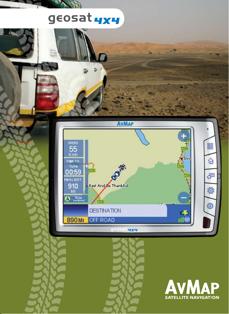
Looking at the navigator you can see the following
components:
1. Keyboard
2. 5” LCD TFT display
3. Slot for Secure Digital memory cards
4. Audio output
5. Microphone
6. Brightness sensor
7. Power supply plug
8. Audio video input
9. Serial port for external GPS antenna
10. Serial port for TMC receiver
11. Speaker
12. USB port
Content of the box
Geosat 4x4 navigator •
Bracket with suction cup •
Car charger •
USB cable•
Audio video cable•
1. MENU
2. DRIVE ME HOME /M ARK
3. WHERE TO GO/ 4X4 MENU
4. ROUTE FUNCTIONS / VOLUME
5. POWER / BRIGHTNESS
Some keys have a double function (e.g. WHERE
TO GO / 4X4 MENU), press the key to get the
first function, press and hold to get the second
function.
5
2
Front view
1
3
4
Side view
6
11
9 10
8
12
7
4
Page 5
1.Main functions for Road navigation
1.1 PLUG & GO!
Position the suction mount bracket on your windscreen and fix your Geosat 4x4 to it. Plug in the power
cable into the cigarette lighter and into Geosat (the battery is completely discharged when you first start
it) and press the POWER hard key on the keyboard. Geosat 4x4 will power up and greet you with a vocal
message “Welcome on board”! Accept the conditions pressing the Accept button on the Touch screen.
The display will now change to the map page and as soon as Geosat receives the first GPS position, you
will hear the message “Ready to Navigate!”
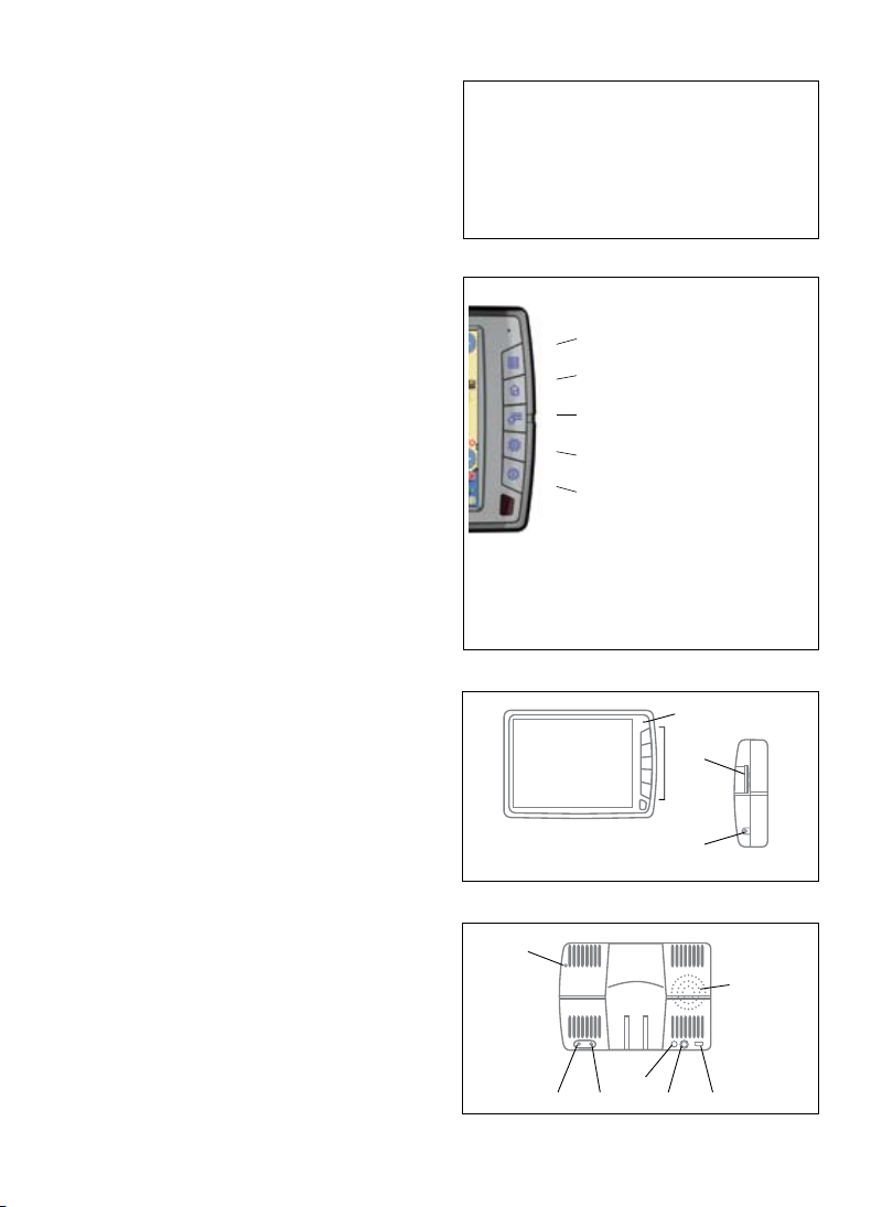
1.2 Exploring the map
With Geosat 4x4 you can consult the map just like in a normal
atlas using the Zoom in or Zoom out buttons.
Touch any point on the map to display the cursor and the
corresponding address will show up in the info bar. Touch on
the information bar to get the full description of all the objects
found in the selected point. Touch and drag to explore the
map in the desired direction.
1.3 Setting your destination
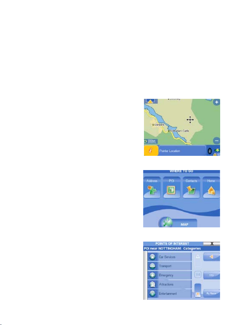
Press the WHERE TO GO hard key to open the Where to go
menu. Press the Address button, then Press New Address
to open the wizard. First, insert the name of the country
with the virtual keyboard, the press the arrow button
to proceed, enter the name of the city, of the street and
the house number. Choose among the possible results to
get to the Start Navigation page. Press the GO button to
start the navigation from your GPS position to the selected
destination. Otherwise press Show on Map to check the
destination on the Map, then press the back arrow button to
go back to the Start Navigation page and press GO.
1.4 Looking for a Point of Interest (POI)
Press the WHERE TO GO hard key to open the Where to go
menu. Press the POI button, to open the POI page. Press
the GPS position button to look for the closest POI, choose
the category and subcategory. Choose one POI from the list
of results to open the Start Navigation page, then press the
GO button. You can also search for recently found POI, POI
close to your destination or by city.
1.5 Saving a contact address
You can save up to 1000 contacts addresses. To save a
5
Page 6

specific address, insert a new address as if you were setting a destination, then in the Start navigation
page press Add to contacts. Insert the name for the contact,
and choose an icon. To save your current location, press the
WHERE TO GO hard key, press the Contacts button, and
then press Add contact. In the Add contact page press Here
to save your current GPS position.
1.6 Setting a contact as departure or destination
All the contacts are saved in the address book. To open the
address book press the WHERE TO GO hard key, press the
Contacts button, then choose one folder form the left column
to see the list of contacts. Press on one contact to open the
Start Navigation page from which you can edit the contact,
delete it or set it as destination, departure or viapoint. Press
the GO button to start the navigation form your GPS position
to the selected contact’s address.
1.7 Drive me Home!
When saving your personal address as a contact, after
editing the name, choose the House icon to set it as Home.
Then to set your Home as destination you simply have to
press the Drive Me Home hard Key on the Geosat keyboard,
and the navigation will start from your current GPS position
to your Home.
1.8 Setting the route options
Press the Route options hard key to open the route options menu.
Here you can choose to Avoid in your route: Toll roads, U turns, Highways, Walkways, Ferry routes,
unpaved roads, built-up areas.
In the second page of route options it is possible to set
the route preferences: Fastest time (gives priority to major
roads), Shortest distance (gives priority to shortcuts even
if they are secondary streets), Fewer turns (gives priority
to the route with the fewer turns) or Off Road. Press Ok to
go back to the user preferences menu, and then close the
menu by pressing the cross button to go back to the map.
1.9 Setting the data boxes
Press the MAIN MENU hard key to open the Main Menu,
press on the Settings button and then press the Set data
boxes button. Press on one data box and then choose the info you would like to display, if you
choose none, the data box will be hidden. Once all of the Data Boxes are set, press OK to go back
6
Page 7

to the settings page. Press on the Map button to go back to
the map.
1.10 Setting the brightness and volume
Brightness: Geosat is equipped with a sensor for the
automatic regulation of brightness of the display. You can
modify the brightness manually by pressing the POWER
hard key to open the Display Options. Adjust the level, or
choose the auto brightness. You can choose also between
day vision and night vision.
Volume: press the Route options hard key to open the
Volume instructions menu. Adjust the level, or choose the
auto Volume (it varies according to speed). You can choose
here between simplified or detailed Voice instructions.
2. Main functions for Off-Road
navigation
2.1 4x4 Functions Menu
Press the MENU hard key and touch the 4x4 Functions button
on the touch screen to open the 4x4 Functions menu.
Tip: while navigating off-road, you can open the 4x4 Menu
just pressing and holding on the central key of the keyboard
(Destination / 4x4 Menu)
The 4x4 Functions menu consists in six buttons:
1.Enable/Disable 4x4 mode – By enabling the 4x4 mode,
you activate all the other buttons of the 4x4 menu, as well as
the 4x4 settings: A -B off road navigation, raster map view (in
the countries where it is available), possibility to transfer the
tracks in NMEA 4800 format, Waypoints saving by LAT LON
(in the DDD. MM.MMM format)
2.Compass - It opens a full screen compass showing speed,
bearing* (shown by the red arrow), course** and distance to
destination. From this page you can access the Trip Master by
touching on “Trip” in the lower right corner of the screen.
3.Trip Master - It opens the full screen Trip master where
you can see: LAT LON of your current position (updating in
real time); bearing, course, altitude and speed. Beside these
data, the Trip computer shows the odometer (partial and total
travelled distance, - that can be zeroed by touching the Reset
button. The Trip Master has a precision of 10 meters. From this page you can access the Compass by
*Bearing, is the direction of the destination, **Course, is your current direction
7
Page 8

touching on “Comp” in the lower right corner of the screen.
4.Contacts - it opens the contacts page where you can find the saved addresses, waypoints (inserted
by LAT LON) and marks (saved by picking on map read par. 2.3)
5.Enable/Disable raster chart – Raster topographic maps for Geosat 4x4 are available for some
countries, in this case, you can choose to display the raster chart (the Tele Atlas maps will be
overlapped) or to hide it (only the Tele Atlas data will be shown). The off road navigation is possible
either ways. Check www.avmap.it for raster charts availability.
6.Tracks – you can record up to 10 tracks, for a total of 10.000 points
TIP: Press and hold the cycle button (the central button in the keyboard) to cycle the following pages:
Maps, Compass and Trip master.
2.2 Navigating off-road
2.2.1 Picking on Map
Explore the map and pick the desired location for the starting point (A), just touching it on the display,
then touch the info bar and touch the green arrow button to open the Start navigation page. Press Set
as departure Point.
Repeat the operation to insert the destination point (B) and in the Start navigation page, touch the GO
button. A straight line will be drawn from to B. This can be done everywhere with or without raster
map, or map data.
2.2.2 Searching by LAT LON
You can insert the departure, the destination and the waypoints by searching them by LAT LON
coordinates.
2.3. Saving Contacts, Marks and Waypoints
You can save in your Geosat 4x4 up to 1000 contacts, among marks, waypoints and addresses. You
can access the contact list by clicking on the contacts button in the 4x4 Functions menu. The Contacts
database has two default folders: marks and waypoints.
Marks are locations you want to mark; they can be saved quickly by picking them on the map.
While you are driving you can save a mark on your current position by pressing and holding the second
key of the keyboard (Drive me Home / Mark). The virtual keyboard will open: you can type the Mark
name or you can skip it, a standard name with a progressive number will be assigned to the Mark, and
it will be saved in the Mark folder. You can then modify the saved marks.
Waypoints can be inserted by touching the Contacts button in the 4x4 Menu, then clicking Add
Contact. Choose how to search the waypoint for example by LAT LON. When you import waypoints
from your PC, they will be saved in this folder.
Addresses can also be saved as contacts (for on road navigation ); search the address as described in
the par 1.3 then in the start navigation page select “Add to contacts”.
You will have to edit it and to create a folder for this address (e.g. friends, work, off road clubs, speed
cameras etc.)
8
Page 9

2.4 Recording your track
Open the 4x4 Functions menu then touch the Tracks button.
Touch New Track, insert the name and choose the colour
for the track. Your off-road movement will be recorded and
a coloured track will be shown on the display. To stop the
registration in the same page select Stop Track. To hide the
coloured track, open the track list, select the track and select
No in the Show on map window.
Geosat 4x4 can register the track of your itinerary on the road
as well as off road. During road navigation, the track points
are saved along the street traced in the Tele Atlas cartography, while to register the exact track off road,
please enable the 4x4 mode.
2.5 Share tracks
Once you have recorded your tracks, you can share them with friends. Thanks to the GeosatUpdate
application you can export tracks to your PC and then import these files in GPS Mapping Software
such as Ozi Explorer. You can also import tracks from Ozi Explorer to your Geosat 4x4. Besides this,
GeosatUpdate allows you updating the Geosat4x4 navigation software for free. You can download
GeosatUpdate for free from www.avmap.it
1.Visit www.avmap.it, enter the Support section and register your product.
2.Once you have obtained the login and password, enter the download, select Geosat 4x4, download
the drivers and install them following the instructions (this operation is required only the first time, in
order to let your PC communicate with your Geosat).
3.Select your product from the scroll down menu and download the GeosatUpdate.
2.5.1 Exporting a Track
In order to export your saved tracks, you first have to save them on the SD card (as they are saved in
the internal memory of the navigator) using the File manager function (read par 2.5.3)
1. Connect your Geosat 4x4 (switched off and not powered) to the PC through the provided USB
cable
2. Start the GeosatUpdate application saved on your PC.
Now you can use the GeosatUpdate application to Export
and Import tracks
3. Click on Tracks management. In the left window you will
see the list of the tracks saved in your Geosat 4x4,
4. select a track and then click on “Export to Ozi Explorer”
to save on your PC the tracks in a Ozi Explorer compatible
format.
5. Touch the X button in the upper right corner to close the
9
Page 10

Geosat Update application. You can now disconnect Geosat 4x4.
6. The file saved on your PC is ready to be imported in Ozi Explorer.
2.5.2 Importing a track
To import in your Geosat 4x4 a track, previously created on Ozi Explorer and saved in your PC:
1. Connect Geosat 4x4 (switched off and not powered) to the PC through the USB cable.
2. Run the GeosatUpdate application previously installed on your PC. Now you can use the application
to import tracks.
1. Click in the same GeosatUpdate window the “Import from Ozi Explorer” button,
2. Choose on your PC the file of the track you wish to import in your Geosat 4x4. GeosatUpdate
will convert the track in a Geosat 4x4 compatible format and will save it in the navigator’s SD
card.
3. Touch the X button in the upper right corner to close the Geosat Update application. You can
now disconnect Geosat 4x4.
You can use the file manager to save the files from the SD to the internal memory of the navigator to
secure them (read par 2.5.3)
2.5.3 File manager
The File manager is a function of Geosat 4x4 that allows moving tracks and waypoint from the internal
navigator’s memory to the SD card and vice versa. You can move files to the SD card to export them,
or move them back to the internal memory, to secure this contents in case of damages to the SD card,
back ups etc.
1. Press the MENU key
2. Touch the File manager button.
3. Touch the Save Tracks button, you can see the list of saved contacts and tracks. In the upper bar
you can see the space already used on the Secure Digital, the left free space and the number of files
saved.
4. Select the tracks you want to save on the SD to export.
5. Insert the name for this file
6. Touch the green arrow button.
Now your tracks are ready to be exported.
Vice versa, you can use the file manager to save the files from the SD to the internal memory of the
navigator (to secure them).
1. Press the MENU key
2. Touch the File manager button.
3. You can see the list of saved contacts and tracks. In the upper bar you can see the space already
used on the Secure Digital, the left free space and the number of files saved.
4. Select the tracks you want to secure on the internal memory of the navigator.
10
Page 11

5. Touch Load button.
Now your files are moved back to the internal memory.
2.6 Transferring Waypoints through NMEA communication to and from Ozi Explorer
If you need to export/import waypoints from your Geosat 4x4 to Ozi explorer during a competition,
there is a faster procedure. You can connect Geosat 4x4 directly to a laptop with Ozi Explorer running
on it through the special Interface serial cable (optional) so that they can communicate through NMEA
protocol. If your PC does not have a serial port, but only USB ports, you can also buy our Serial - USB
cable adapter. To buy optional cables visit www.avmap.it
1. Switch Geosat 4x4 on and connect the serial cable to the Geosat 4x4 serial port, and to the PC serial
port .
2. Open Ozi Explorer and click on configuration
3. Set GPS Make = “NMEA only” , and GPS symbol = “Default”, Control also in the COM section
if the right PC port is selected, then click Save to save the settings.
4. Set the Geosat 4x4 in 4x4 mode ( par. 2.1)
From Geosat 4x4 to Ozi Explorer:
In the Geosat 4x4 main menu, touch the 4x4 button and then touch on Contacts. 1.
In the Contacts Page select the desired folder2.
Click on “GPS- only NMEA” in the upper of Ozi Explorer and select Get Waypoint from GPS3.
Touch the SEND button to transfer the waypoints to the PC.4.
To send waypoints from Ozi Explorer to the Geosat 4x4, select Send Waypoints
From Ozi Explorer to Geosat 4x4:
Click on “GPS- only NMEA” in the upper of Ozi Explorer and select Send Waypoint to GPS
3.Technical specifications
Hardware
• Dimensions (139.7 x 100 x 36) mm
• Weight 390 g
• 5” LCD TFT Touchscreen
• Brightness 450 nit
• Contrast 250:1
• Resolution 320 x 240 px
• Number of colours 65536
• Manual or automatic brightness control
• Built-in Sirf III GPS receiver 20 channels
• Built-in rechargeable Li-Ion battery
• Secure Digital memory card
• Processor Arm9 300 MHz
• RAM 32 MB
11
Page 12

• Backlit keyboard
• Built-in speaker
• Power supply 10 35 V
• Maximum consumption 7 W
• Operating temperatures 0°C 50°C
• Storage temperatures -25°C 60°C
• Serial port for (optional) external GPS antenna
• Serial port for (optional) external TMC receiver and for Bi-directional NMEA communication
• Audio video input (PAL NTSC)
• Audio output
• Infrared sensor
• USB port
• Bluetooth
Minimum PC requirements (for Software updates):
Microsoft Windows ME, 2000, XP, 2003 server
64 Mb free space on Hard Disc
64 MB RAM
USB Port
Maps
Raster charts for off road background navigation are available for some countries, check www.avmap.
it for availability and prices.
4. Repair and replacement under warranty
When a Conformity Defect has been confirmed, the Purchaser must contact the authorised Support
Centre for national territory by one of the following methods:
Web procedure
The Purchaser should visit the www.avmap.it website and click on “Technical Support.” The Purchaser
will be required to complete an on-line assistance request form. Once the form has been processed,
the Support Centre will send the Purchaser an authorisation number by email. The Purchaser may
then send the broken equipment to the national competent Supporting Centre for the reparation on
guarantee. The purchaser can also write to info@avamp.it
Telephone procedure
Contact +39 0585 784044 and explain your problem to the Support Centre operator. The operator
12
Page 13

will give you an authorization number and the address of the support centre. The Purchaser may
then send the broken equipment to the national competent Support Centre for the reparation on
guarantee.
For repairs carried out under guarantee or Product replacement, the validity of the warranty continues
to have effect from the date on the tax document. The Product control and the Conformity Defect
Check are exclusive competence of the Support Centre.
5. Tele Atlas End User Agreement
END USER AGREEMENT, RESTRICTIONS AND PROHIBITIONS IN THE USE OF TELE ATLAS
CARTOGRAPHY AND COPYRIGHTS WARNINGS
RESTRICTIONS:
• The cartographic data are licensed for internal business or personal use only and not for transfer,
distribution, or disclosure to third parties or for the benefit of third parties
• The cartographic data use is limited to the user
PROHIBITIONS:
• Operation of a service bureau or any other use involving the processing of data of other persons
43
or entities
• Use of the Licensed Products other than (1) with software provided by Licensee; or, if applicable,
(2) while connected to Licensee’s website
• Assignment, time-sharing, lend or lease, or rental of the Licensed Products
• Title to or any ownership interest in the Licensed Products passing to the End User or any other
party deriving or attempting to derive the structure of the Licensed Products
• Use, duplication (except for a single archival copy), reproduction, disclosure, publication,
distribution, or transfer of the Licensed Products other than as specifically allowed
• The removal or obscuring of any copyright, trademark notice, or restrictive legend
• The modification or creation of derivative works of the Licensed Products
• Use of the Licensed Products to provide competitive information about TA or the Licensed
Products to third parties
• Creation of a derivative product that competes with the Licensed Products
ADDITIONAL PROVISIONS TO BE INCLUDED BY LICENSEE:
1. TA is a third party beneficiary of AvMap rights under the EULA, but is not a party thereto and shall
have no obligations hereunder.
2. Disclaim, to the extent permitted by applicable law, TA’s liability for any damages, or loss of any
kind, whether special, direct, indirect, incidental, or consequential, arising from the use of the Licensed
Products.
3. Disclaim all warranties of TA, whether express or implied, including but not limited to, the implied
warranties of non-infringement, merchantability, completeness, accuracy, and fitness for a particular
purpose.
4. End User has to be acknowledged that the Licensed Products include confidential and proprietary
information and materials and may include trade secrets.
13
Page 14

5. Require End User to comply with all applicable export laws and regulations of the United States /
the European Community.
6a. (Applicable for US data Only) Include the following: U.S. GOVERNMENT RIGHTS. If End User
is an agency, department, or other entity of the United States Government, or funded in whole or
in part by the United States government, then use, duplication, reproduction, release, modification,
disclosure or transfer of this commercial product and accompanying documentation, is restricted
in accordance with FAR 12.212 and DFARS 227.7202, and by a license agreement. Contractor/
manufacturer is Tele Atlas North America, Inc., 1605 Adams Drive, Menlo Park, CA 94025, (650)
328-3825. The Licensed Products are ©1984-2003 by Tele Atlas N.V. and Tele Atlas North America,
Inc. ALL RIGHTS RESERVED. For purpose of any public disclosure provision under any federal, state
or local law, it is agreed that the Licensed Products are a trade secret and a proprietary commercial
product and not subject to disclosure.
6b. (Applicable for US data only) Include the following: If End User is an agency, department, or other
entity of any State government, the United States Government or any other public entity or funded in
whole or in part by the United States Government, then End User hereby agrees to protect the Licensed
Products from public disclosure and to consider the Licensed Products exempt from any statute, law,
regulation, or code, including any Sunshine Act, Public Records Act, Freedom of Information Act, or
equivalent, which permits public access and/or reproduction or use of the Licensed products. In the
event that such exemption is challenged under any such laws, this EULA shall be considered breached
and any and all right to retain any copies or to use of the Licensed Products shall be terminated and
considered immediately null and void. Any copies of the Licensed Products held by Licensee shall
immediately be destroyed. If any court of 44 competent jurisdiction considers this clause void and
unenforceable, in whole or in part, for any reason, this EULA shall be considered terminated and
null and void, in its entirety, and any and all copies of the Licensed Products shall immediately be
destroyed.
7. (Applicable for data of Denmark only). If Licensee licenses the Tele Atlas MultiNet™ data of Denmark
to an End User, Licensee must also include the following terms in its EULA with the End
User: Prohibit End User from using the Tele Atlas MultiNet™ data of Denmark to create maps within
telephone books, telephone books or other products similar to telephone books (e.g. directories),
including such products in digital form.
8. (Applicable for data of Norway only). If Licensee licenses the Tele Atlas MultiNet™ data of Norway
to an End User, Licensee must also include the following terms in its EULA with the End User: Prohibit
End User from using the Tele Atlas MultiNet™ data of Norway to create general purpose printed or
digital maps, which are similar to the basic national products of the Norwegian Mapping Authority.
(Any Derivative Product of the Tele Atlas MultiNet™ data of Norway shall be regarded as similar to the
basic national products of the Norwegian Mapping Authority if such Derivative Product has a regional
or national coverage, and at the same time has a content, scale and format that are similar to the basic
national products of the Norwegian Mapping Authority.)
9. (Applicable for POI’s of the USA only). If Licensee licenses POI’s of the USA to an End User,
it is required that Licensee includes the following warranty disclaimer: “THE PREMIUM POI’S ARE
PROVIDED “AS IS” WITHOUT WARRANTY OF ANY KIND. IN NO EVENT WILL TELE ATLAS’S
THIRD PARTY SUPPLIER(S) OF THE PREMIUM POI’S BE LIABLE IN ANY WAY WITH REGARD TO
THE PREMIUM POI’S.”
10. If Licensee wishes to license the U.S. municipal boundaries product, currently marketed as
14
Page 15

Dynamap®/Municipal Boundaries, as one of the Licensed Products, then Licensee shall not use the
Municipal Boundaries product to create or derive applications which are used for the purpose of tariff
or tax rate determination for a particular address or range of addresses.
11. (applicable for data of United Kingdom only)
• Licensee shall prohibit the removal or obscuring of any copyright, trademark or restrictive
legend belonging to Ordnance Survey.
• Ordnance Survey disclaims any warranty on Tele Atlas Multinet data for Great Britain
• Ordnance Survey prohibits using Tele Atlas Data for printed publications.
LIST OF COPYRIGHTS
Europe “Data Source © <2006> Tele Atlas N.V.”
Austria “© BEV, GZ 1368/2003.”
Denmark “© DAV”
France Michelin data © Michelin 2006
45
Great Britain This product includes data by Ordnance Survey with authorization of Her Majesty’s
Stationery Office controller. © Crown copyright
and database right 2006. All rights reserved. License number
100026920
Italy “© Geonext/DeAgostini”
Northern Ireland “© Ordnance Survey of Northern Ireland”
Norway “© Norwegian Mapping Authority, Public Roads Administration / ©
Mapsolutions.”
Switzerland “© Swisstopo”
Netherlands “Topografische ondergrond Copyright © dienst voor het kadaster en de
openbare registers, Apeldoorn 2004”
Products for North America (US and Canada)
“© 2006 Tele Atlas North America, Inc. / Geographic Data Technology, Inc. All rights reserved.
This material is proprietary and the subject of copyright protection and other intellectual property
rights owned by or licensed to Tele Atlas North America, Inc. / Geographic Data Technology, Inc.
The use of this material is subject to the terms of a license agreement. You will be held liable for any
unauthorized copying or disclosure of this material.”
Canada
“Canadian Data © DMTI Spatial” (on CD/DVD);
“Portions of Canadian map data are reproduced under license from Her Majesty the Queen in Right
of Canada with permission from Natural Resource Canada.
Prodotti nordamericani (Stati Uniti e Canada)
“© 2006 Tele Atlas North America, Inc. / Geographic Data Technology, Inc. All right s reserved. This
material is proprietary and the subject of copyright protection and other intellectual property rights
owned by or licensed to Tele Atlas North America, Inc. / Geographic Data Technology, Inc. The use of
this material is subject to the terms of a license agreement. You will be held liable for any unauthorized
copying or disclosure of this material.”
Canada “Canadian Data © DMTI Spatial” (on CD/DVD); “Portions of Canadian map data are
reproduced under license from Her Majesty the Queen in Right of Canada with permission from
Natural Resource Canada.” (in documentation)
15
Page 16

AvMap s.r.l.
V.le Zaccagna 6, 54033
Avenza - Carrara (MS) - Italia
info@avmap.it
16
 Loading...