

Page 1
Heading large > KievitPro Regular 23 on 23 pt, 75%
When our customers bring in their old drawings
black. Ut enim ad mini mim veniami quis nostrud
that might have been sitting in a drawer for
exercitation ullam, corpor suscipit laboris Lorem
years, it’s safe to say that the quality of the
ipsum etalus siti amet, duis autem conitu secutur
drawings may have degraded from age, water
adipscing elitsef diam eiusmod magnus. Etion
damage, or just plain old dirt. Scans that result from
®
AutoCAD
ullam, corpor suscipit laboris Lorem ipsum etalus
such damaged drawings aren’t the highest quality;
siti amet, duis autem conitu secutur adipscing
however, with the powerful suite of tools in Raster
elitsef diam eiusmod magnus.
Design, including rubbersheeting, despeckling,
and others, we can massage the data and make it
accurately convey the design intent once again.
— Michael C. Johnson
CEO
Advanced Career Development
Learn More or Purchase
Access specialists worldwide who can provide product expertise, a deep
understanding of your industry, and value that extends beyond your software
purchase. To purchase AutoCAD Raster Design software, contact an Autodesk
Premier Solutions Provider or Autodesk Authorized Reseller. Locate a reseller
near you at www.autodesk.com/reseller.
To learn more about AutoCAD Raster Design, visit
www.autodesk.com/rasterdesign.
Looking for high-resolution aerial and satellite imagery as well as vector data for
your projects? Visit www.autodesk.com/geodata.
Raster Design
Image is everything.
Autodesk Learning and Education
From instructor-led or self-paced classes to online training or education
resources, Autodesk oers learning solutions to fit your needs. Get expert
guidance at an Autodesk Authorized Training Center (ATC
tools online or at your local bookstore, and validate your experience with
Text heading > KievitPro Bold 8.5 on 10.5 pt, product family color
Autodesk certifications. Learn more at www.autodesk.com/learning.
Body Text > KievitPro Regular 8.5 on 10.5 pt, black. lorem ipsum etalus sit amet,
duis autem consecutur adipscing elit, sef diam nonumy eiusmod tempor incident
Autodesk Services and Support
ut labore magna aliquam erat volupat. Ut enim ad minimim veniami quis
Accelerate return on investment and optimize productivity with innovative
nostrud exercitation ullam, corpor suscipit laboris nisi ut aliquip ex ea commodo
purchase methods, companion products, consulting services, and support from
conseauat. Duis autem vel eum irure etalus in reprehjenderit in volupate velit
Autodesk and Autodesk authorized partners. Designed to get you up to speed
ewsse moestai xom consequat.
and keep you ahead of the competition, these tools help you make the most
of your software purchase—no matter what industry you are in. Learn more at
Text heading
www.autodesk.com/servicesandsupport.
Body Text. Vel illum etalusim eu fugiat nulla pariartur —ignissim qui blandit
praes entl upatum delenit aigue duos etalus et molestais excepturisio toccaecet
Autodesk Subscription
cupidat non. Lorem ipsum etalus sit amet, duis autem consecutur adipscing elit,
Get the benefits of increased productivity, predictable budgeting, and simplified
sef diam nonumy eiusmod te mpor incident ut labore magna aliquam erat.
license management with Autodesk
of your Autodesk software and any incremental product enhancements, if
Text heading
these are released during your subscription term. In additon, you get exclusive
Body text. Lorem ipsum etalus sit amet, duis autem consecutur adipscing elit,
license terms available only to Subscription members. A range of community
sef diam nonumy eiusmod tempor incident ut labore magna aliquam erat
resources, including web support direct from Autodesk technical experts,
volupat. Ut enim ad minimim veniami quis nostrud exercitation ullam, corpor
self-paced training, and e-Learning, help extend your skills and make Autodesk
suscipit laboris nisi ut aliquip ex ea commodo conseauat. Duis autem vel eum
Subscription the best way to optimize your investment. Learn more at
irure etalus in reprehjenderit.
www.autodesk.com/subscription.
Autodesk is c ommitted to sustainab ility. This brochure is prin ted on percent postconsu mer waste recycle d paper.
Autodesk , AutoCAD, Civil D, and Topobase are register ed trademarks of Au todesk, Inc., an d/or its subsidiaries
and/or aliates in the USA and/or oth er countries. All othe r brand names, pro duct names, or tra demarks belong
to their resp ective holders . Autodesk reserves th e right to alter produc t oerings and sp ecifications at any time
Legal text > K ievitPro Regular 6 on 8 pt , black — Registered tra demarks of Autodes k, Inc., in the USA
without notice, and is not resp onsible for typograp hical or graphical errors that may appear in this document.
and/or other countries. All o ther product name s, brand names, or t rademarks belo ng to their respective
© Autode sk, Inc. All right s reserved.
holders . © 2008 Autode sk, Inc. All rights re served. par t number
®
Subscription. You get any new upgrades
®
) site, access learning
Page 2
Designs Enhanced
Approvals Accelerated
Helping design professionals across a broad range of
industries—civil; GIS/mapping; mechanical, electrical, and
plumbing (MEP); architectural; and manufacturing.
“While we are working
to create digital versions
of our older paper maps,
we use Raster Design
to edit and maintain
scanned maps digitally.
The software helps us
maintain our existing maps
and lets us easily find and
use our raster assets.”
— Greg Ammon
Water GIS Systems Manager
Los Angeles Department of
Water and Power
Make the most of rasterized scanned drawings,
maps, aerial photos, satellite imagery, and digital
elevation models. Get more out of your raster data
with AutoCAD
Use AutoCAD Raster Design software with
AutoCAD
Civil, AutoCAD
AutoCAD
AutoCAD
Topobase™ software to unlock and extend
the value of existing design information.
®
Raster Design software.
®
, AutoCAD® Architecture, AutoCAD®
®
Civil D®, AutoCAD® Electrical,
®
Map D, AutoCAD® Mechanical,
®
MEP, AutoCAD® P&ID, and Autodesk®
AutoCAD Raster Design enables you to work in an
AutoCAD environment, significantly reducing the
need to purchase and learn multiple applications.
Extend the Value of Existing Information
Unlock and make the most of existing scanned
engineering drawings, plans, and maps by using
them in current projects. You can save redrafting
time with powerful raster editing and raster-tovector conversion tools.
Perform raster drawing cleanup, editing and manipulation,
raster-to-vector conversion, and image processing while
working with a breadth of imagery.
Improve Decision Making
Get projects approved faster by creating drawings
and presenting proposals that integrate informationrich plans, maps, aerial photos, and other forms
of imagery that enhance communication and
understanding of your design intent.
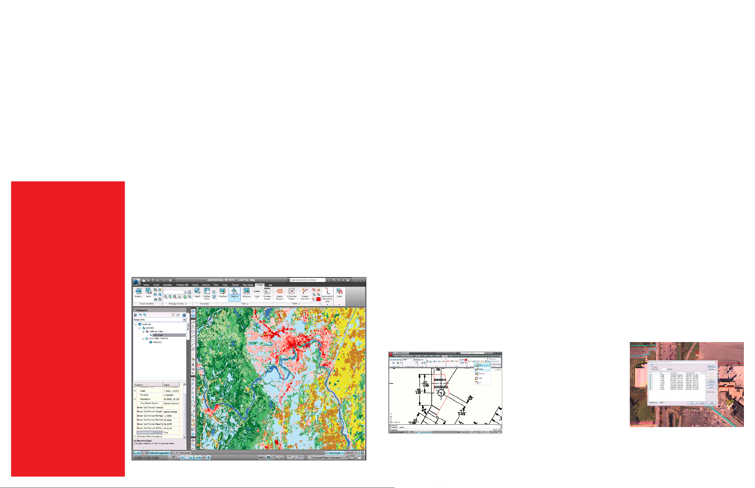
When used with AutoCAD Map D-based software,
AutoCAD Raster Design provides additional
functionality so you can better utilize geospatial
imagery to create color elevation representations
directly from DEM, DTED, and ESRI
files. Visualize the slope and aspect information
you need to help make better design and policy
decisions. Show vegetation, land cover, and
environmental information using readily available
multispectral satellite imagery.
Enhance, Preserve, and Maintain Valuable
Raster Assets
AutoCAD Raster Design software enables you to
easily clean up, edit, enhance, and maintain your
archive of scanned drawings and plans with image
cleanup, processing, and hybrid editing tools in a
familiar AutoCAD environment.
®
GRID raster
Use Industry-Standard Image Formats
AutoCAD Raster Design supports numerous image
formats so designers can easily integrate and use
imagery within their projects. Supported image
formats include MrSID,
DigitalGlobe
format multispectral imagery, and the National
Imagery Transmission Format (NITF), which is an
important tool for the U.S. Department of Defense
and the federal intelligence community.
Other supported formats include the following:
BMP CALS DEM
DOQ ESRI GRID FLIC
GeoSPOT GeoTIFF GIF
IG JPEG/JFIF DTED
PCX PICT PNG
RLC TGA TIFF
Clean Raster Drawings and Images
Improve usability and legibility of scanned drawings
with powerful image cleanup tools. Despeckle
removes stray pixels that result from scanning dirty
or faded drawings or blueprints. Deskew corrects
drawings that were crooked as they were fed through
a scanner. Bias corrects distortion in an image’s aspect
ratio. Mirror can correct transparencies that have
been scanned upside down. By using these and other
tools, you can reduce the time and eort necessary
to clean up scanned drawings and maps while better
maintaining your image archives.
®
Quickbird TIFF, Landsat FAST-LA
®
ECW, and JPEG ,
other image-processing features in AutoCAD Raster
Design can help improve the appearance of existing
images, so you can get the full benefit from your
investment in imagery.
Convert Raster Data to Vector
Do you want to be able to use scanned drawings and
map content without having to redraft? Would you
like to convert raster lines, arcs, and text to vector
for use in AutoCAD-based products as part of your
drawing, model, or design? With vectorization tools in
AutoCAD Raster Design, you can interactively convert
raster to vector to accelerate project turnarounds and
improve eciency.
Use Optical Character Recognition
Recognize machine and hand-printed text and
tables on raster images to create AutoCAD text
or multiline text (mtext) automatically. Use
interactive verification to correct results with
dictionary matching. Save manual data entry
time and improve accuracy when converting
scanned documents with a lot of text.
Incorpor ate widely available geosp atial raster data that can b e used to visualize informati on such as land cover.
image from USG S National Land Cover Data base
.
Data used in
Accurately vec torize partial or entire s canned sheets
using t he semiautom atic and interactive raster-to-vector
conversion utilit ies.
Enhance Images with Intuitive
Image-Processing Tools
Several image-processing features are available to help
designers get the most from existing imagery. The
histogram feature includes functions to equalize images,
adjust brightness and contrast, convert grayscale or
color images to bitonal images, and perform nonlinear
tonal adjustments. The convolve feature has smoothing
filters to reduce ruggedness and noise as well as
sharpening filters to make dierences in shading more
distinct. The invert feature reverses the light and dark
shades of binary, color, and grayscale images. These and
Use correlat ion tools such as the unlimited point
rubbers heet function to align aer ial photos to drawings.
 Loading...