

Page 1
Technical Data Sheet
InterferenceHunter
™
Handheld Direction Finding System
MA2700A
Includes GPS and Electronic Compass
Introduction
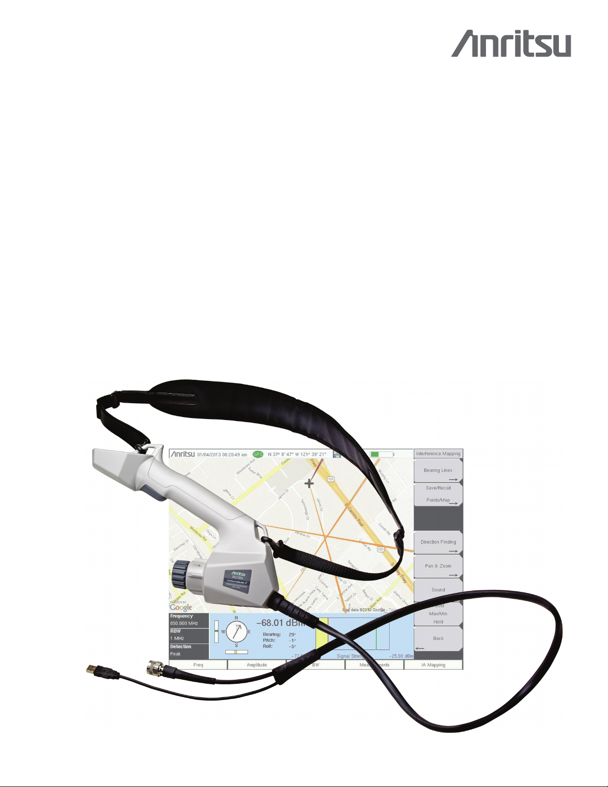
Simplify your interference hunting tasks with the Handheld Interference
This broadband, easy-to-use handheld direction finding antenna system includes everything you need to find the
sources of signals. With a broadband preamplifier, the system is sensitive. With a GPS receiver, it knows where it is.
With the electronic compass it knows where it is aimed. With an antenna attached, the Interference
direction and signal level when the user presses the trigger on the ergonomic handle.
The included adjustable shoulder strap conveniently holds the MA2700A when out in the field. The ergonomic handle
can be used with antennas having a female Type-N connector located at the back of the antenna. The included coupling
nut allows for easy antenna connection. Compatible antennas in many cellular bands are available from Anritsu. For
details on these antennas including frequency range, gain, and pattern information, refer to the Directional Antennas
Technical Data Sheet (11410-00376) available for download from the Anritsu web site.
Combined with Interference Analysis (Option 25) on Anritsu’s instruments, the captured location and bearing data is
displayed on the instrument.
Hunter™ from Anritsu Company.
Hunter
captures a
Compact Size: 303 mm x 220 mm x 70 mm (11.9 in x 8.7 in x 2.76 in), Lightweight: < 1 kg (2.2 lb)
Interference
Hunter
MA2700A Handheld Direction Finding System
Page 2

Specifications Interference Hunter™ MA2700A
Specifications
All specifications and characteristics apply to Revision 1 instruments. All published specifications are typical.
Power Consumption
Preamplifier On
Preamplifier Off
Preamplifier
Bandwidth
Electronic Compass
Power
Accuracy≤ 5°
Interface
GPS Receiver
Satellites Tracked
GPS Locking Time
Position Uncertainty
Cables
Tripod Mount
Electromagnetic Compatibility
European Union
Interference
Emissions
Immunity
Australia and New Zealand
Safety
Safety Class
Environmental
Operating Temperature
Maximum Humidity
Altitude
Shock
Storage
Size and Weight
Weig ht
0.6 Watts
0.5 Watts
10 MHz to 6 GHz
Gain≥ 8 dB: 10 MHz to 2.4 GHz
≥
5 dB: > 2.4 GHz to 4 GHz
≥
3 dB: > 4 GHz to 6 GHz
Powered from USB
USB
12 (maximum)
Cold start: 30 s, typical, with a clear view of the sky
Warm start: 2 s, typical, with a clear view of the sky
± 2 meter, typical
USB cable terminated with a USB Type A Female Plug, 1.5 meters
Coaxial cable with Type-N male connector, 1.5 meters
1/4 - 20 UNC x 7 mm
CE Mark, EMC Directive 2004/108/EC and Low Voltage Directive 2006/95/EC
EN 61326-1
EN 55011
EN 61000-4-2/-4-3/-4-4/-4-5/-4-6/-4-11
C-tick N274
EN 61010-1 Class 1
–10°C to +55°C
95 % non-condensing
4600 meters
MIL-PRF-28800F Class 2
–40°C to 71°C
Size
303 mm x 220 mm x 70 mm (11.9 in x 8.7 in x 2.76 in)
< 1 kg (2.2 lb)
How to Use the MA2700A
Connections
• Connect an antenna to the male N-connector (inside the coupling nut).
• Connect USB cable between the MA2700A and the instrument. Connect coaxial cable between the MA2700A and the instrument's RF Input
connector.
Instrument Setup
• Confirm that the instrument has SPA module V6.00 or higher.
• Select the Interference Analysis (Option 25) mode on the instrument, then select Interference Mapping measurement.
• The instrument will detect the connected MA2700A and display the message MA2700 detected -- Device is ready to use. After GPS lock,
the instrument will use GPS data from the MA2700A.
• To manually select the MA2700A: In the Measurements menu, press Interference Mapping twice. Choose the Direction Finding submenu
then Direction Finding Antenna Selection, and select MA2700 Handheld.
Mapping
• Anritsu easyMap Tools is used to create maps that are displayed on the Anritsu instrument. The software is available from the Anritsu web site.
2 PN: 11410-00692 Rev. B MA2700A TDS
Page 3

Interference Hunter™ MA2700A Ordering Information
Standard Accessories
Optional Accessories
Directional Antennas
MA2700A Transit Case
(included with instrument)
Part Number Description
2000-1729-R Shoulder Strap
Part Number Description
2000-1411-R 822 MHz to 900 MHz, N(f), 10 dBd, Yagi
2000-1412-R 885 MHz to 975 MHz, N(f), 10 dBd, Yagi
2000-1413-R 1710 MHz to 1880 MHz, N(f), 10 dBd, Yagi
2000-1414-R 1850 MHz to 1990 MHz, N(f), 9.3 dBd, Yagi
2000-1415-R 2400 MHz to 2500 MHz, N(f), 10 dBd, Yagi
2000-1416-R 1920 MHz to 2170 MHz, N(f), 10 dBd, Yagi
2000-1659-R 698 MHz to 787 MHz, N(f), 8 dBd, Yagi
2000-1660-R 1425 MHz to 1535 MHz, N(f), 12 dBd, Yagi
2000-1727 Monopod
Part Number Description
760-261-R Transit Case, space for MA2700A, antennas, filters, instrument
inside softcase, and other interference hunting accessories/tools.
Additional Documents and Software
• Spectrum Analyzer Measurement Guide applicable for your Anritsu Instrument. The Interference Analysis chapter will include a section on
“Interference Mapping” with information on setup and selecting the MA2700A as the Direction Finding Antenna.
• Anritsu easyMap Tools software creates Geo-enabled maps which are viewed on the Anritsu instruments during interference hunting.
• Directional Antennas Technical Data Sheet (11410-00376) lists compatible antennas in many frequency bands.
• The User Guide for your Anritsu instrument.
These documents and programs along with additional applications notes, white papers, and videos covering interference analysis are available
from the Anritsu web site (www.anritsu.com).
MA2700A TDS PN: 11410-00692 Rev. B 3
Page 4

The Master Users Group is an organization dedicated to providing training, technical support, networking opportunities and links to Master
product development teams. As a member you will receive the Insite Quarterly Newsletter with user stories, measurement tips, new product
news and more.
Visit us to register today: www.anritsu.com/mug
To receive a quote to purchase a product or order accessories visit our online ordering site: www.ShopAnritsu.com
Training at Anritsu
Anritsu has designed courses to help you stay up to date with technologies important to your job. For available training courses visit:
www.anritsu.com/training
• United States
Anritsu Company
1155 East Collins Blvd., Suite 100,
Richardson, TX 75081, U.S.A.
Toll Free: 1-800-267-4878
Phone: +1-972-644-1777
Fax: +1-972-671-1877
• Canada
Anritsu Electronics Ltd.
700 Silver Seven Road, Suite 120,
Kanata, Ontario K2V 1C3, Canada
Phone: +1-613-591-2003
Fax: +1-613-591-1006
• Brazil
Anritsu Electrônica Ltda.
Praça Amadeu Amaral, 27 - 1 Andar
01327-010 Paraiso, São Paulo, Brazil
Phone: +55-11-3283-2511
Fax: +55-11-3288-6940
• Mexico
Anritsu Company, S.A. de C.V.
Av. Ejército Nacional No. 579 Piso 9, Col. Granada
11520 México, D.F., México
Phone: +52-55-1101-2370
Fax: +52-55-5254-3147
• United Kingdom
Anritsu EMEA Ltd.
200 Capability Green, Luton, Bedfordshire LU1 3LU,
U.K.
Phone: +44-1582-433280
Fax: +44-1582-731303
• France
Anritsu S.A.
12 Avenue du Québec,
Bâtiment Iris 1-Silic 612,
91140 VILLEBON SUR YVETTE, France
Phone: +33-1-60-92-15-50
Fax: +33-1-64-46-10-65
• Germany
Anritsu GmbH
Nemetschek Haus, Konrad-Zuse-Platz 1
81829 München, Germany
Phone: +49-89-442308-0
Fax: +49-89-442308-55
List Revision Date: 20121226
• Italy
Anritsu S.r.l.
Via Elio Vittorini 129, 00144 Roma, Italy
Phone: +39-06-509-9711
Fax: +39-06-502-2425
• Sweden
Anritsu AB
Borgafjordsgatan 13A, 164 40 KISTA, Sweden
Phone: +46-8-534-707-00
Fax: +46-8-534-707-30
• Finland
Anritsu Finland
Teknobulevardi 3-5, 01530 Vantaa, Finland
Phone: +358-20-741-8100
Fax: +358-20-741-8111
• Denmark
Anritsu A/S (for Service Assurance)
Anritsu AB (for Test & Measurement)
Kay Fiskers Plads 9, DK-2300 Copenhagen S,
Denmark
Phone: +45-3691-5035
Fax: +45-7211-2210
• Russia
Anritsu EMEA Ltd.
Representation Office in Russia
Tverskaya str. 16/2, bld. 1, 7th floor.
Russia, 125009, Moscow
Phone: +7-495-363-1694
Fax: +7-495-935-8962
• United Arab Emirates
Anritsu EMEA Ltd.
Dubai Liaison Office
P O Box 500413 - Dubai Internet City
Al Thuraya Building, Tower 1, Suite 701, 7th Floor
Dubai, United Arab Emirates
Phone: +971-4-3670352
Fax: +971-4-3688460
• Singapore
Anritsu Pte. Ltd.
60 Alexandra Terrace, #02-08, The Comtech
(Lobby A)
Singapore 118502
Phone: +65-6282-2400
Fax: +65-6282-2533
• India
Anritsu India Pvt. Ltd.
2nd & 3rd Floor, #837/1, Binnamangla 1st Stage,
Indiranagar, 100ft Road, Bangalore - 560038, India
Phone: +91-80-4058-1300
Fax: +91-80-4058-1301
• P.R. China (Shanghai)
Anritsu (China) Co., Ltd.
Room 1715, Tower A CITY CENTER of Shanghai,
No.100 Zunyi Road, Chang Ning District,
Shanghai 200051, P.R. China
Phone: +86-21-6237-0898
Fax: +86-21-6237-0899
• Hong Kong
Anritsu Company Ltd.
Unit 1006-7, 10/F., Greenfield Tower,
Concordia Plaza,
No. 1 Science Museum Road, Tsim Sha Tsui East,
Kowloon, H ong Kong
Phone: +852-2301-4980
Fax: +852-2301-3545
• Japan
Anritsu Corporation
8-5, Tamura-cho, Atsugi-shi,
Kanagawa, 243-0016 Japan
Phone: +81-46-296-1221
Fax: +81-46-296-1238
• Korea
Anritsu Corporation, Ltd.
502, 5FL H-Square N B/D, 681
Sampyeong-dong, Bundang-gu, Seongnam-si,
Gyeonggi-do, 463-400 Korea
Phone: +82-31-696-7750
Fax: +82-31-696-7751
• Australia
Anritsu Pty Ltd.
Unit 21/270 Ferntree Gully Road, Notting Hill
Victoria, 3168, Australia
Phone: +61-3-9558-8177
Fax: +61-3-9558-8255
• Taiwan
Anritsu Company Inc.
7F, No. 316, Sec. 1, Neihu Rd., Taipei 114, Taiwan
Phone: +886-2-8751-1816
Fax: +886-2-8751-1817
This Technical Data Sheet applies to Revision 1 of the MA2700A InterferenceHunter. Instruments not indicating a revision level are Revision 1
instruments.
® Anritsu All trademarks are registered trademarks of their
respective companies. Data subject to change without notice.
For the most recent specifications visit: www.anritsu.com
Anritsu prints on recycled paper with vegetable soybean oil ink.
MA2700A Interference Hunter™TDS
Copyright May 2013 Anritsu Company, USA
All Rights Reserved
 Loading...