

Page 1
Page 2

Table of contents
Contents
Part 1 Product introduction 2
Part 2 Features 3
Part 3 Safety notes 4
Part 4 Quick user guide 5
Part 5 Operation notes 7
Part 6 USB driver installation guide 9
Part 7 Using with PDA 17
Part 8 Trouble shooting 28
1
Page 3
Part 1 Product introduction
Overview
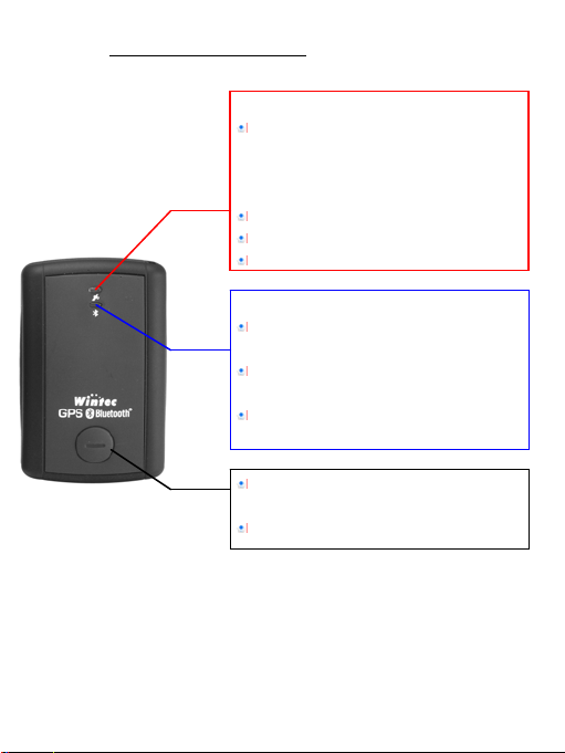
GPS LED: (Green LED)
Green LED Solid light shows location
fixing incomplete .Blink light shows
location fixing completed.
Power LED: (Red LED)
Red light blinks if battery power is low.
Red light solid on while charging.
After fully charged red light will snuff out.
Bluetooth LED:
Light turns off when Blue tooth
connection is off.
Blue light solid on when Blue tooth
connection initiates.
Blue light blinks if Blue tooth connection
succeeds.
Temporarily press this to turn on/off
Bluetooth.
Press and hold this to turn power on/off.
2
Page 4

Part 2 Features
WBT-200 is the GSP receiver with internal antenna. u-Nav + iTrax 03
used in its core is high-tech component and included function of autolog record of journey, which are useful in navigation, security tracking
purpose, map making and other agricultural needs. USB connector or
Bluetooth interface ensures easy linking with other electronic
devices .The GPS acquisition status, the last record of time and
position can all be stored in unfailing memory. It has 12 GPS channels
and its low power-consumption can last continuous 10 hours of
operation. WBT-200 can boast of its smallest size ever with fullest
features in the world.
WBT-200 uses iTrax 03 GPS module (u-Nav base) and the high-
performance CPU.
Maximum 12 channels can be acquisitioned quickly.
Internal decode ”WAAS/EGNOS” is used excluding the need for
external hardware in receiving WAAS/EGNOS signal(depend on
firmware).
System supports NMEA0183 3.0 for data transfer.
Data-logging acts like the in-flight black box and can record of
position, date and time as long as power source is maintained.
For down-load of log-data and programming of WBT-200, provided
software tool “G-Tool” can simplify usage.
The system is upgradeable with new software which is provided
free from us.
It is designed to be water-proof.
Data link thru bluetooth within 10 meter range.
Versatile design aimed for car/personal navigation, fleet
management, AVL, tracking and mapping purpose.
3
Page 5

Part 3 Safety notes
GPS (Global Positioning System) is provided by the United States
government. Its accuracy may varies depending on special
conditions (area at war or if it is blocked). Any control by USA will
affect this system and its accuracy .
If installed on the transportation device, driver must not operate
this while driving.
GPS performance is affected when satellite coverage is degraded
as near a high-rise building, in the tunnel or under a cover.
Personal replacement of components and re-structuring of this is
prohibited and may result in loss of legal usage.
Operation of this device is strictly prohibited in highly explosive
environment such mining, in-flight or other unauthorized area
against use of this.
Avoid exposing this at places of high temperature and humidity.
Return to original dealer immediately if it emits strange smell or
fume.
4
Page 6

Part 4 Quick user guide
Package :WBT-200(bluetooth GPS with logger)+USB cable+
sticker +car cigarette lighter power adapter , installation Disk,
Quick use guide.
WBT-200 Operation:
Temporarily press power button to turn it on. The bluetooth and
GPS status LED will glow to confirm it is in GPS mode.
GPS LED glows green to show GPS acquisition is done (1 Hz).
But if this LED is solid on, the GPS acquisition fails.
Temporarily press on power button. Bluetooth will turn off after
bluetooth LED goes off. Another press on power button can turn
bluetooth on after its LED glows again.
After power on, press and hold power button to turn the power
off.
If Power LED (glows red) starts to blink, the power is low and
needs recharging. Power LED (glows red) stays solid while
charging .It snuff out red LED after it is fully charged.
When the USB is used as interface:
USB driver must be installed first.
After connection to USB port of computer, place the WBT-200 at
suitable area where it can best receive GPS signal for
acquisitioning.
Power it (or switch its power on).
WBT-200 will start acquisition.
When the bluetooth is used as interface:
Ahead of bluetooth connection, make sure the target device to
pair can support bluetooth SPP master.
After pairing with WBT-200, place it at suitable area where it
5
Page 7

can best receive GPS signal for acquisitioning.
Activate the software of paired device. WTB 200 starts to
provide GPS data.
Battery charging:
Connect WBT-200 with USB cable and turn on power source.
To charge it, power source can be supplied from USB host that
from computer, power adapter, or car cigarette lighter adapter.
6
Page 8

Part 5 Operation notes
WBT-200 will do self-check once it is powered. Bluetooth and GPS
start to work when both Bluetooth LED (glows blue) and GPS LED
(glows green ) turns on. GPS automatically starts acquisition and
auto-logs. If sky is clear overhead, it requires only 40 sec for
acquisition. (If the data in its memory is still valid, it needs only
8~35 sec). After acquisition, WBT-200 starts output data of
position, speed and time in NMEA0183 format.
For the first time if it is placed at the area well exposed to the
satellite signal, this device requires approx 13 min (theoretically
12.5 min) to receive or update Almanac. Refer to trouble shooting
guide when signal is not received well.
If WBT-200 formatting the internal data is not correct, or if satellite
data has been deleted, it takes longer time to position. But under
the following conditions, it can take even longer time to do cold
start.
If it is not in use for over 3 months (the almanac too old).
If the recorded data is over 500 km.
After positioning, WBT-200 transfers navigation data thru export
interface as below:
Latitude
Longitude
Altitude
Speed
Date
Time(UTC time)
Estimated error
Satellite status
Receiving status
7
Page 9

After positioning, if auto-log function is activated, WBT-200 begins
to auto-log the following way.
Maximum data up to 25360 Points (or more than).
Recording in a circular way.
Auto-logging goes on without the need of any device.
Log-data can be read out using the G-Tool software included.
Data can be read out thru USB or Bluetooth.
Data includes latitude, longitude, altitude and time in year-
month-date-hour-min-sec.
After successful positioning, it wills automatically auto-log GPS
data into its internal memory chip. It recorded in a rotational
order. The earliest (oldest) data will replaced by the latest
(newest) one when memory space is full (when data excesses
25360 maximum).
Auto-log will continue even the Bluetooth is switched off.
When auto-log function is disable. Its power will be off after 10
minutes while the Bluetooth is switched off. It will not shut down
while auto-log function is activated.
8
Page 10

Part 6 USB driver installation guide
1、 Execute installation and click “Install”.
9
Page 11

2、 Installation is done when this screen displays.
10
Page 12

3、 Use USB cord to connect WBT-200 to the USB port of computer.
Computer will automatically check it and seek driver software by
itself. If PC asks for “device manager” for adding the new USB
device following USB device connection, take the procedure
below. Click “next”.
11
Page 13

4、 The screen will display as below. Click “continue anyway”.
12
Page 14

5、 Installation completed.
13
Page 15

6、 Immediately afterwards, PC will ask again to install “GPS
Receiver Virtual Com Port” driver. Click “ next ”.
14
Page 16

7、 Installation completed.
To check the installation status, go to the “device manager” .
15
Page 17

8、 As in the illustration, the USB device (marked in red circle) is
correctly installed to PC. The illustration also shows USB being
transferred to Com Port assigned as COM4. In the future,
whenever the USB device is connected to USB port on the
computer, the COM 4 acts as the interface for data
communication.
16
Page 18

Part 7 Using with PDA
Use of this with PDA for location check.
It is necessary to install GTOOL(PPC) first in your PDA. Follow the
following steps.
Step 1:Turn WBT-100 Bluetooth device Power on and then create
Bluetooth connection with PDA.
Step 2:Supported by GTOOL(PPC), location can be viewed on PDA .
Step 1:Bluetooth connection to PDA.
1、Tap the Bluetooth icon on PDA’s taskbar to view the Bluetooth menu.
Tap the” Turn Bluetooth ON” to enable Bluetooth.
17
Page 19

2、Tap the Bluetooth icon again and select the ”Bluetooth Manager”.
3、From Bluetooth Manager toolbar, tap ”New” to search for any other
Bluetooth devices in its vicinity.
18
Page 20

4、Tap “Explore a Bluetooth device” to view Bluetooth devices services
and create a shortcut to them. Click“Next” to continue.
5、Tap “BT-GPS” icon to view the device services.
19
Page 21

6、Select “SPP slave” services and tap “Next” to create a shortcut to it.
7、Tap “Finish” to complete procedure.
20
Page 22

8、From the “My Shortcuts” tab, tap the “BT-GPS: SPP slave” icon and
select the “Connect” option to connect to it.
9、When a connection is successfully established, the shortcut icon
turns green.
21
Page 23

Step 2:Using GTOOL(PPC) for locating .
The GTOOL(PPC) enables you to view your position by latitude and
longitude, speed, heading, and altitude. Make sure that the GTOOL(PPC)
had been installed on your PDA as described in GPS CD.
1、Tap“Start” and select the“ File Explorer ”item from the start menu.
OR click the “GTool” item, then jump to step 4.
22
Page 24

2、At “My Device” tab, tap the “Program Files”, then select “GTool” case.
3、In the “GTool” case, tap the GTool icon to start it.
23
Page 25

4、At “Connect Setting” tab, select Bluetooth com port on your PDA at
“Select GPS Port” item and click Connect ,than select BT- GPS icon.
(Connect successfully)
5、In the “GPS Data” tab, location data is displayed as below.
24
Page 26

6、Feature in other tabs :
“Log Mode Setting ”:Log mode setting.
“Read Log”:Read or clean the Log data.
LOG File (*.tks) default path save as “...\My Documents\*.tks”.
25
Page 27

“NMEA Setting”: Set the NMEA output.
“Init. Mode”: Reboot, Factory Reset, Cold Start, and the firmware version.
( Note:If use these features, Bluetooth maybe need re-connect!)
26
Page 28

“Satellite”:View Satellite Information.
“Sky Plot”:View Satellite Distribution in the sky.
27
Page 29

Part 8 Trouble shooting
The GPS signal will become weak under the following conditions.
If the vehicle enters the tunnel. The GPS signal transmits linearly
down to earth and its signal is blocked out in this situation.
GPS satellite coverage gets poor because of high-rise building or
thick forest. Even though WBT-200 can receive reflected weak
GSP signal, the data might be less accurate.
The sun shade in the vehicle can partially block out GPS signal
and effect good reception. The GPS satellite is under control of
USA and the accuracy might vary depending on some special
purpose (as may be required by USA).
It is a normal situation when GPS data displayed by the receiver
device shows a big difference from real position because of
unstable atmospheric condition which causes GPS axis to drift
from actual map axis occasionally.
Some navigation software can only decode latitude/longitude from
NMEA0183 provided by logger. No altitude information is available
and therefore it cannot define vehicle’s position whether that is
over or under the bridge.
After successful positioning of WBT-200, if it is moved to another
area of 500 km away it cannot be easily re-positioned. This is
because the firstly recorded data (position, time and number of
satellites acquisitioned) is different from the new area. It will need
longer time for re-positioning.
When the power LED flashes red, the battery is critically low and
needs re-charging. If it is not recharged within 30 min, GPS will
stop to work to prevent total exhaust of power.
PIN code will be requested after Bluetooth connection initiates
between GPS and PDA. Enter code as 0000.
Avoid placing 2 GPS devices too close during positioning.
28
Page 30

Bluetooth connection takes 5 seconds for self-check. Each time the
device is switched on; it needs 5 seco nds before connection.
It is normal if the Bluetooth coverage might become short
sometimes due to environmental interferences.
USB driver must be installed first before connecting the device to
the USB port of computer. Make sure of the right COM PORT
being used.
If disconnection between PDA and GPS is done in a abnormal way,
PDA will halt. Try to disconnect Bluetooth connection in a standard
method.
If the WBT-200 is found to work abnormally because of wrong
procedure, reset it by taking off the battery. It will have factory
default without effecting pre-set program. At the factory default,
GPS reception begins in a quick start mode and its position may
take longer time.
If WBT-200 is used for navigation but found unworkable after
connection is done. Make sure the format of NMEA0183 that the
software is used. Then use G-Tool to set it (Refer to the G-Tool
operation guide).
29
 Loading...