

Page 1
Bluetooth-GPS receiver
WBT-100
USER’S MANUAL
Ver 1.0 R2
1
Page 2

Table of contens
Contents
Part 1 Product introduction 3
Part 2 Features 4
Part 3 Technical specifications 5
Part 4 Safety notes 7
Part 5 Quick user guide 8
Part 6 Operation notes 9
Part 7 USB driver installation guide 11
Part 8 Software interface 18
Part 9 Trouble shooting 24
2
Page 3
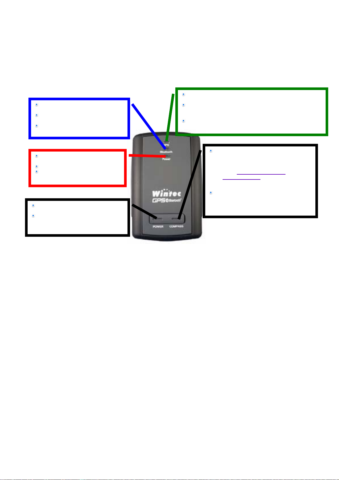
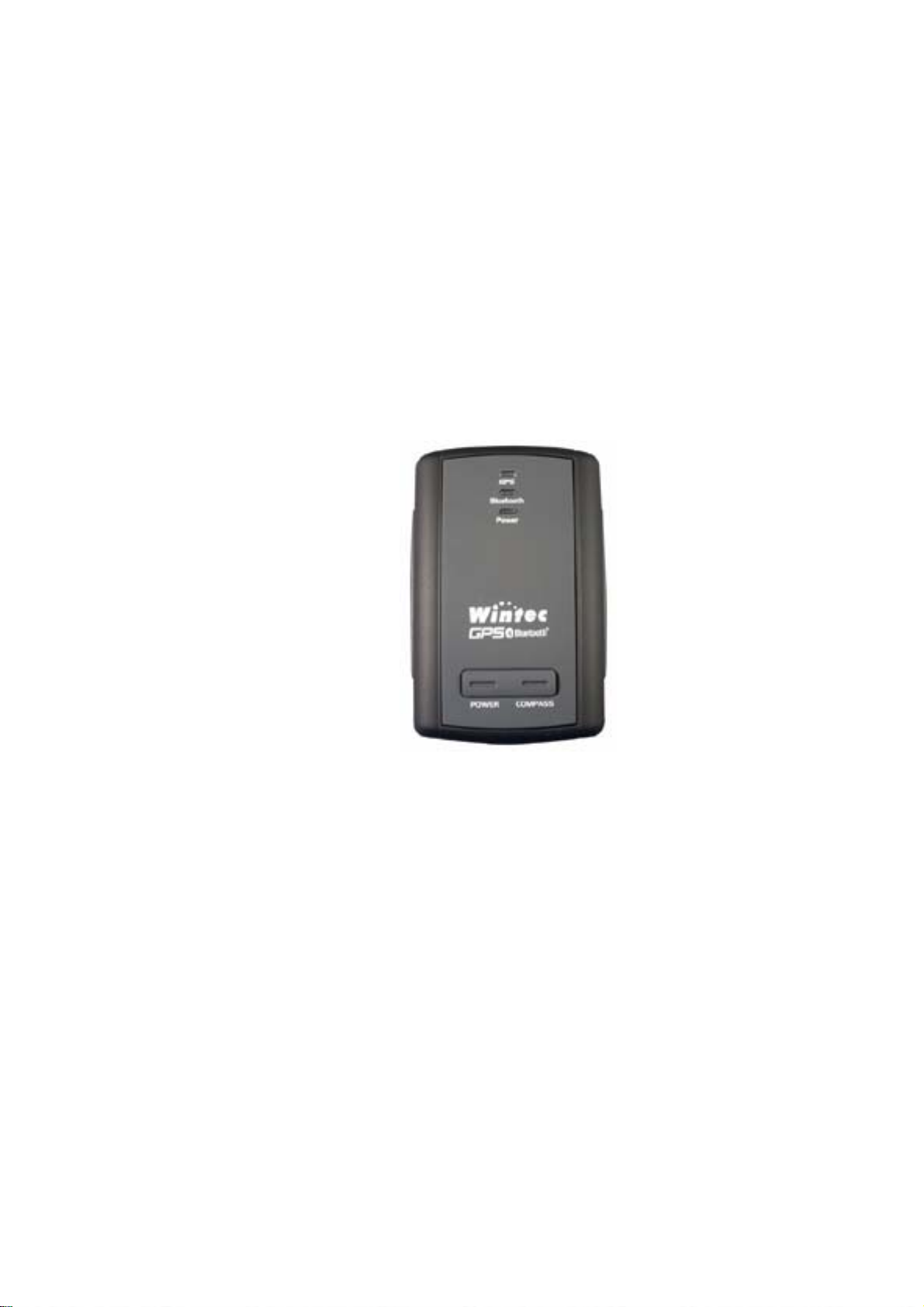
Part 1 Product introduction
Overview
Light turns off when Blue tooth
connection is off
Blue light solid on when Blue tooth
connection initiates
Blue light blinks if Blue tooth
connection succeeds
Red color: GPS mode: Solid light shows location fixing
incomplete Blink light shows location fixing completed
Green color: Compass mode: Solid light shows North
direction (The slower LED blinks, the farther it tur ns from
North.)
Orange color: In calibrating mode
Red light blinks if battery power is
low
Red light solid on while charging
Green light solid on after fully
charged
Temporarily press this to turn on/off
Bluetooth
Press and hold this to turn power
on/off
Temporarily press to change mode
between GPS mode and Compass. While
in calibrating, temporary press on this
button makes system enter into Compass
mode if calibrating succeeds
( if calibration fails
mode.
Press and hold this to enter
auto-calibrating mode
) system will enter GPS
. Otherwise
3
Page 4

Part 2 Features
WBT-100 is the GSP receiver with internal antenna. iTrax 03 used in its core is high-tech
component and is integrated with electronic compass to the effect of providing more accurate
GPS data(this innovative concept is patent ed by Wintec) especially during navigation when
the vehicle is moving slowly.
It can also auto-log record of journey, which are useful in navigation, security tracking purpose,
map making and other agricultural needs. USB connector ensures easy linking with other
electronic devices.The GPS acquisition status, the last record of time and position can all be
stored in unfailing memory. It has 12 GPS channels and its low power-consumption can last
continuous 9 hours of operation. WBT-100 can boast of its smallest size ever with fullest
features in the world.
WBT-100 uses iTrax 03 GPS module (the 3rd generation) and the high-performance CPU
(ARM7TDMI CPU)
Maximum 12 channels can be acquisitioned quickly
Internal decode”WAAS/EGNOS” is used excluding the need for external hardware in
receiving WAAS/EGNOS signal
System supports NMEA0183 3.0 for data transfer
Internal electronic compass is used to get the compass/GPS inter-calibrating effect
Electronic compass can work independently to find north
With the integral support of electronic compass, NMEA data output can make navigation
more reliable
Data-logging acts like the in-flight black box and can record of position, date and time as
long as power source is maintained
For down-load of log-data and programming of WBT-100, provided software tool “G-tool”
can simplify usage
The system is upgradeable with new software which is provided free from us
It is designed to be water-proof
Data link thru blue tooth within 10 meter range
Versatile design aimed for car/personal navigation, fleet management, AVL, tracking and
mapping purpose
4
Page 5

Part 3 Technical specifications
General specs
Chips:u-Nav + iTrax 3rd generation of least power consumption with highest sensitivity
Number of channels:Receivable of signal from 12 satellites simultaneously
Receiving freq.:1575.42 MHZ。
Receiving code:L1, C/A code。
Sensitivity:-152dBm
Positioning time (average)
Re-acquisition time: 0.1 sec。
Quick Start: < 3 sec(within 25 min from last signal)
Cold start time:40 sec。
Warm start time :38 sec
Hot start time : 8 sec。
Data update automatically in every sec
Accuracy
GPS acquisition in general: Accuracy range 25 meters (dependant on surroundings)
Supportive GPS features: Accessible to EGNOS/WAAS
Position error:
< 3 meter when 3D error is at 95%。
< 6 meter when 2D vertical error is 95%。
Speed: error within 0.2 meter per sec
Acceleration: Maximum 4G (G is gravity unit)
Time:20ns。
Size
Integral parts: Receiving module, blue tooth, rechargeable Li-Ion battery, internal high
sensitive antenna
Measurement (L) 60.0 x (W)38.0 x (H)16.0 mm 。
Battery performance
Charging voltage:+3.75~+5.5V DC。
Internal Li-Ion rechargeable battery
9 continuous working hours after fully charged
5
Page 6

Environmental specs
Working temp range:-10℃~70℃( internal temp)。
Storage temp range:-40℃~85 ℃。
Bluetooth interface
Version: 1.1
Data output rate: Class 2
Data transmission range:5~10 meter(depends on environment)
Freq range: 2402~2480MHz
Receiving sensitivity:-80dBm
Power consumption :< 45mA (depends on data transfer)
Service: SPP SLAVE
USB specs
Interface type::Standard USB connector of computer
Data transfer rate:9600bps。
Data output:
GPS internal standard axis WGS84
NMEA-183 Version 3.0. ASCII output
GPRMC (default)
GPGSV (default)
GPGSA (default)
GPGGA (default)
GPGLL
GPVTG
GPZDA
6
Page 7

Part 4 Safety Notes
GPS (Global Positioning System) is provided by the United States government. Its
accuracy may varies depending on special conditions (area at war or if it is blocked). Any
control by USA will affect this system and its accuracy.
If installed on the transportation device, driver must not operate this while driving
GPS performance is effected when satellite coverage is degraded as near a high-rise
building, in the tunnel or under a cover
Personal replacement of components and re-structuring of this is prohibited and may
result in loss of legal usage
Operation of this device is strictly prohibited in highly explosive environment such
mining ,in-flight or other unauthorized area against use of this
Avoid exposing this at places of high temperature and humidity
Return to original dealer immediately if it emits strange smell or fume
7
Page 8

Part 5 Quick use guide
Package :WBT-100(blue tooth GPS logger)+USB cable+ sticker +car cigarette lighter
power adaptor , installation Disk, Quick use guide
WBT-100 Operation
Temporarily press power button to turn it on. The blue tooth and GPS status led will
glow to confirm it is in GPS mode
GPS Led glows red to show GPS acquisition is done ( 1 Hz). But if this led is solid on,
the GPS acquisition fails.
Temporarily press on power button. Blue tooth will turn off after blue tooth led goes off.
Another press on power button can turn blue tooth on after its LED glows again.
Temporarily press on mode button each time can switch between compass mode
(LED glows green) and GPS mode (LED glows red)
It is strongly recommended to have WBT-100 calibrated in any
environment ahead of use. Press and hold the mode button to enter
into calibration status which is displayed by orange LED. Press shortly
again the same button to get out of calibration status and remain in
compass mode (LED glows green). But if calibration fails, it will jump
into GPS mode (LED glows red in this situation)
After power on, press and hold power button to turn the power off.
If red LED starts to blink, the power is low and needs recharging. Led stays solid while
charging .It glows green after it is fully charged.
When the USB is used as interface:-
USB driver must be installed first
After connection to USB port of computer, place the WBT-100 suitable
area where it can best receive GPS signal for acquisitioning
Power it(or switch its power on)
WBT-100 will start acquisition
When the blue tooth is used as interface:-
Ahead of blue tooth connection, make sure the target device to pair
can support blue tooth SPP master
After pairing with WBT 100, place it at suitable area where it can best
receive GPS signal for acquisitioning
Activate the software of paired device. WTB 100 starts to provide GPS
8
Page 9

data
Battery charging
Connect WBT 100 with USB cable and turn on power source
To charge it , power source can be supplied from USB host from
computer, or from power adapter or car cigarette lighter adapter
Part 6 Operation notes
WBT 100 will do self-check once it is powered. Blue tooth and GPS start to work when
both blue and red LED turns on. GPS automatically starts acquisition and auto-logs. If sky
is clear overhead, it requires only 40 sec for acquisition. (If the data in its memory is still
valid, it needs only 8~35 sec). After acquisition, WBT100 starts output data of position,
speed and time in NMWA0183 format.
For the first time if it is placed at the area well exposed to the satellite signal, this device
requires approx 13 min (theoretically 12.5 min) to receive or update Almanac. Refer to
trouble shooting guide when signal is not received well.
If WBT-100 formatting the internal data is not correct, or if satellite data has been deleted,
it takes longer time to position. But under the following conditions, it can take even longer
time to do cold start.
If it is not in use for over 3 months (the almanac to too old)
If the recorded data is over 500 km
After positioning, WBT-100 transfers navigation data thru export interface as below.
Latitude
Longitude
Altitude
Speed
Date
Time(UTC time)
Estimated error
Satellite status
Receiving status
After positioning, if auto-log is activated, WBT 100 begins to auto-log the following way.
Maximum data up to 12680
Recording in a circular way
Auto-logging goes on without the need of any device
Log-data can be read out using the G-tool software included
9
Page 10

Data can be read out thru USB or bluetooth
Data includes latitude, longitude, time in year-month-date-min-sec
After successful positioning, it wills automatically auto-log GPS data into its internal
memory chip. Use G-tool to program log interval (1~ 3600 sec). The factory default is
set at 5 sec interval for the auto-logging. If interval is set to 0 sec, this auto-log
feature is deactivated. Log data is recorded in a rotational order. The earliest (oldest)
data will replaced by the latest (newest) one when memory space is full (when data
excesses 12680 maximum).
Auto-log will continue even if the Bluethooth is off.
If interval 0 sec is set, auto-log stops to work. Its power will be off after 10 min the
Bluetooth is switched off. Auto-log will not shut down if interval is set higher-than 0 sec.
Part 7 USB Driver Installation Guide
1 Execute installation and click “Install”.
“
2 Installation is done when this screen displays.
10
Page 11

3 Use USB cord to connect WBT-100 to the USB port of computer. Computer will
automatically check it and seek driver software by itself. If PC asks for “ device
manager” for adding the new USB device following USB device connection, take the
procedure below . Click “next”
4 The screen will display as below. Click “continue anyway”
11
Page 12

5 Installation completed
6 Immediately afterwards, PC will ask again to install “Wintec GPS Receiver Virtual Com
Port” driver. Click “ next’
12
Page 13

7 Installation completed
To check the installation status, go to the “device manager”
8 As in the illustration, the USB device(marked in red circle) is correctly installed to PC.The
illustration also shows USB being transfered to Com Port assigned as COM 3. In the
13
Page 14

future, whenever the USB device is connected to USB port on the computer, the COM 3
acts as the interface for data communication.
Part 8 Software interface
WBT-100 Software Interface output asbelow.
NMEA ((National Marine Electronics Association) 0183 Version 3.0 (ASCII Format)
Baud Rate: 9600 bps, 8(Data Bits), Stop bit, No parity
WBT 100 Factory Setting
Function describe
Communication data and setting
NMEASupport Format
GPRMC, GPGSV, GPGSA, GPGLL, GPGGA, GPVTG, GPZDA
Default GPRMC, GPGSV, GPGSA, GPGGA
baud rate 9600 bps
Receiver mode status
GPS GPS data will be auto-logged according to the interval. If
interval is programmed to “0”, auto log features is deactivated.
Bluetooth will turn off after 10 min from deactivation of auto-log
for the power saving purpose.
Electronic compass Under compass mode, north direction can easily be found. If
used is a new surrounding, re-calibrate again for accuracy
Bluetooth After Bluetooth connection is initiated but connection is not
established in 5 min, WBT-100 will automatically turn off for the
14
Page 15

power saving purpose. If Bluetooth reconnection is needed
again , just momentarily press “power” button one time.
Auto-log features
Auto log interval at default 5sec
Auto log interval 1~3600 Sec.(0 is diableLog)
Maximum log data 12680
NMEA-0183 export data
NMEA Explanation
GPGGA (factory default) GPS Data
GPGSA(factory default ) GNSS DOP
GPGSV (factory default) GNSS number of satellites
GPRMC (factory default) Recommended minimum specific GPS data
GPGLL Geologic position latitude/ longitude
GPVTG Course Over ground and ground speed
GPZDA Date and time
$GPGGA,hhmmss.dd,xxmm.dddd,<N|S>,yyymm.dddd,<E|W>,v,ss,d.d,h.h,M,g.g,M,a.a,xxxx*h
h<CR><LF>
UTC time of the fix.
hh = hours.
hhmmss.dd
mm = minutes.
ss = seconds.
dd = decimal part of seconds.
Latitude coordinate.
xxmm.dddd
xx = degrees.
mm = minutes.
dddd = decimal part of minutes.
<N/S> Character denothing either N = North or S =South.
Longitude coordinate.
yyymm.dddd
yyy = degrees.
mm = minutes.
dddd = decimal part of minutes.
<E/W> Character denothing either E = East or W = West.
Fix valid indicator
v
0 = Fix not valid
1 = Fix is valid
ss
Number of satellites used in position fix, 00-12. Notice: Fixed
length field of two letters.
d.d HDOP – Horizontal Dilution Of Precision.
h.h Altitude (mean-sea-level, geoid)
15
Page 16

M Letter M.
g.g
Difference between the WGS-84 reference ellipsoid surface
and the mean-sea-level altitude.
M Letter M.
a.a NULL (not implemented)
xxxx NULL (not implemented)
*hh Check sum
<CR><LF>
End
Ex:$GPGGA,084053.39,6016.3051,N,02458.3735,E,0,00,0.0,46.6,M,18.2,M,,*5D
$GPGSA,a,b,xx,xx,xx,xx,xx,xx,xx,xx,xx,xx,xx,xx,p.p,h.h,v.v*hh<CR><LF>
a Mode:
M = Manual, forced to operate in 2D or 3D mode.
A = Automatic, allowed to automatically switch 2D/3D.
b Mode: 1 = Fix not available
2 = 2D,
3 = 3D,
xx ID (PRN) numbers of GPS satellites used in solution
p.p PDOP
h.h HDOP
v.v VDOP
*hh Check sum
<CR><LF> End
Ex:$GPGSA,A,3,06,10,15,16,21,25,30,,,,,,2.1,1.2,1.8*38
16
Page 17

$GPGSV,n,m,ss,xx,ee,aaa,cn,…………. ,xx,ee,aaa,cn*hh<CR><LF>
n Total number of messages, 1 to 3
m Message number, 1 to 3
ss Total number of satellites in view
xx Satellite ID (PRN) number
ee Satellite elevation, degrees 90 max
aaa Satellite azimuth, degrees True, 000 to 359
cn Signal-to-noise rations (C/No) 00~60 dB-Hz. Value of zero
means that the satellite is predicted to be on the visible sky
but it isn't being tracked.
*hh Check sum
<CR><LF>
End
Ex:
$GPGSV,4,1,14,03,66,207,50,08,09,322,44,11,01,266,42,14,00,155,00*79
$GPGSV,4,2,14,15,41,088,48,17,21,083,44,18,57,087,51,21,57,173,50*78
$GPGSV,4,3,14,22,05,203,00,23,52,074,49,26,17,028,44,27,00,300,00*79
$GPGSV,4,4,14,28,32,243,00,31,48,286,00*70
$GPRMC,hhmmss.dd,S,xxmm.dddd,<N|S>,yyymm.dddd,<E|W>,s.s,h.h,ddmmyy,d.d,
<E|W>,M*hh<CR><LF>
hhmmss.dd UTC time of the fix.
hh = hours.
mm = minutes.
ss = seconds.
dd = decimal part of seconds.
S Status indicator
A = valid
V = invalid
Latitude coordinate.
xxmm.dddd
xx = degrees.
mm = minutes.
dddd = decimal part of minutes.
<N/S> Character denothing either N = North or S =South.
Longitude coordinate.
yyymm.dddd
yyy = degrees.
mm = minutes.
dddd = decimal part of minutes.
17
Page 18

<E/W> Character denothing either E = East or W = West.
s.s Speed in knots.
h.h Heading.
ddmmyy UTC Date of the fix.
dd = day of month
mm = month
yy = year
d.d Magnetic variation in degrees, i.e. difference between
geometrical and magnetic north direction.
<E|W> Letter denothing direction of magnetic variation. Either E =
East or W = West.
M Mode indicator
A=autonomous
N=data not valid
*hh Check sum
<CR><LF>
End
$GPRMC,095035.91,A,6016.3066,N,02458.3832,E,1.08,210.6,131204,6.1,E,A*0A
$GPGLL,xxmm.dddd,<N|S>,yyymm.dddd,<E|W>,hhmmss.dd,S,M*hh<CR><LF>
xxmm.dddd Latitude coordinate.
xx = degrees.
mm = minutes.
dddd = decimal part of minutes.
<N|S> Character denothing either N = North or S =South.
yyymm.dddd Longitude coordinate.
yyy = degrees.
mm = minutes.
dddd = decimal part of minutes.
<E|W> Character denothing either E = East or W = West.
hhmmss.dd UTC time of the fix.
hh = hours.
mm = minutes.
ss = seconds.
dd = decimal part of seconds.
S Status indicator
A = valid
V = invalid
18
Page 19

M Mode indicator
A=autonomous
N=data not valid
*hh Check sum
<CR><LF>
End
Ex:$GPGLL,6016.3073,N,02458.3817,E,090110.10,A,A*61
$GPVTG,h.h,T,m.m,M,s.s,N,s.s,K,M*hh<CR><LF>
h.h Heading in degrees.
T Letter 'T' denoting True heading in degrees.
m.m Magnetic heading in degrees.
M Letter 'M' denoting Magnetic heading in degrees.
s.s Speed in knots.
N Letter 'N' denoting speed in knots.
s.s Speed, km/h.
K Letter 'K' denoting speed in km/h.
M Mode indicator
A=autonomous
N=data not valid
*hh Check sum
<CR><LF>
End
Ex:
$GPVTG,202.6,T,208.7,M,0.38,N,0.7,K,A*0D
19
Page 20

$GPZDA,hhmmss.dd,dd,mm,yyyy,xx,yy*hh
hhmmss.dd UTC time of the fix.
hh = hours.
mm = minutes.
ss = seconds.
dd = decimal part of seconds.
dd UTC day of month
mm UTC month
yyyy UTC year
xx Local zone hours. Not implemented, output always 00.
yy Local zone minutes. Not implemented, output always 00.
*hh Check sum
<CR><LF>
End
Ex.
$GPZDA,061724.46,17,04,2003,00,00*61
Part 9 Trouble shooting guide
The GPS signal will become weak under the following conditions
If the vehicle enters the tunnel.The GPS signal transmits linearly down to earth and its
signal is blocked out in this situation.
GPS satellite coverage gets poor because of high-rise building or thick forest. Even
though WBT-100 can receive reflected weak GSP signal , the data might be less accurate
The sun shade in the vehicle can partially block out GPS signal and effect good reception.
The GPS satellite is under control of USA and the accuracy might vary depending on
some special purpose(as may be required by USA)
It is a normal situation when GPS data displayed by the receiver device shows a big
difference from real position because of unstable atmospheric condition which causes
GPS axis to drift from actual map axis occasionally
Some navigation softwares can only decode latitude/latitude from NMEA0183 provided by
logger. No altitude information is available and therefore it cannot define vehicle’s positioin
whether the is over or under the bridge.
After successful positioning of WBT-100, if it is moved to another area of 500 km away it
cannot be easily re-positioned. This is because the firstly recorded data(position, time and
number of satellites acquisitioned) is different from the new area. It will need longer time
for re-positioning.
20
Page 21

When the power LED flashes red, the battery is critically low and needs re-charging. If it is
not recharged within 30 min, GPS will stop to work to prevent total exhaust of power.
PIN code will be requested after Bluetooth connection initiates between GPS and PDA.
Enter code as 0000.
Bluetooth connection takes 5 sec for self-check. Each time the device is switched on, it
needs 5 sec before connection
It is normal if the Bluetooth coverage might become short sometimes due to
environmental interferences.
Avoid placing 2 GPS devices too close during positioning.
USB driver must be installed first before connecting the device to the USB port of
computer. Make sure of the right COM PORT being used.
If disconnection between PDA and GPS is done in a normal way, PDA will halt. Try to
disconnect Bluetooth connection in a standard method.
If the WBT-100 is found to work abnormally because of wrong procedure, reset it by
taking off the battery. It will have factory default without effecting pre-set program. At the
factory default, GPS reception begins in a quick start mode and its position may take
longer time.
If USB cable will be used for the connection of WBT-100 and PC, install the USB driver
first on the PC and make sure of right COM PORT.
If WBT-100 is used for navigation but found unworkable after connection is done. Make
sure that the software NMEA0183 is used. Then use G-tool(Refer to the G-Tool operation
guide )
If the compass direction is not accurate, re-calibrate the WBT-100. Follow the calibration
procedure.
21
 Loading...