

Page 1
Page 2

Voxtrack 500 Navigatio n Software User Guide
Page 2 of 59
Notices, Disclaimers and Terms of Use
1. Limited Product Warranty. Destinator Technologies Inc. warrants to the Client that the Products shall
substantially conform to Destinator Technologies’s specification for a period of one (1) year from the date of the
original purchase by the end user (the "Warranty Period"). As Destinator Technologies 's sole obligation and
Client's exclusive remedy for any breach of warranty, Destinator Technologies agrees, at its sole option, to (i)
use reasonable efforts to repair the Product with new or refurbished replacement parts; (ii) replace the Product
with a new or refurbished unit; or (iii) refund the purchase price, provided Client returns the defective Products
to Destinator Technologies with proof of purchase and Destinator Technologies’s authoriza tion.
Destinator Technologies’s warranty hereunder does not apply in case of any damage caused by accident,
abuse, misuse, misapplication, or alteration of any kind performed by anyone other than Destinator
Technologies. The Products are not designed or licensed for use in mission-critical applications, or in
hazardous environments, requiring fail-safe controls, including without limitation operation of nuclear facilities,
aircraft navigation or communication systems, air traffic control, or life support or weapons systems. Without
limiting the generality of the foregoing, Destinator Technologies specifically disclaims any express or implied
warranty or condition of fitness for such purposes. Destinator Technologies’ s warran ty does not, in any event,
apply to physical damage to the surface of the Product or replacement. Destinator Technologies shall have no
obligation with respect to any data stored in the Product.
Except as expressly stated in this section, Destinato r Technologies makes no warranties or includes any
conditions with respect to the products, express or implied, including, but not limited to, the implied warranties
or conditions of merchantability, fitness for a particular purpose and no infringement.
2. Liability Limitation. In no event shall Destinator Technologies, be liable to Client, (and Client hereby
waives any indirect, special, incidental, or consequential damages in connection with) the transactions
contemplated by this agreement, whether or not such damages were foreseen, or their likelihood disclosed.
Destinator Technologies shall not be liable to Client or any third party claiming through Client, for any damages
of any kind in excess of the amounts paid by Client under the terms of this agreement with respect to the
products giving rise to such damages. Some jurisdictions do not allow the exclusion of or limitation on implied
conditions, warranties or damages, thus some of the foregoing may not apply to Client.
3. Intellectual Property Rights. Hardware and Software are proprietary to Destinator Technologies or its
suppliers and are subject to copyright and other intellectual property laws. Client's only rights with respect to
any Destinator Technologies software included with the Products shall be provided, under the terms of
Destinator Technologies ’s software license. Title to all Destinato r Technologies Software remains with
Destinator Technologies. Client agrees that Destinator Technologies retains ownership of all rights, title and
interest in all intellectual property, works of authorship, trade secrets and like’s in all aspects of the Product(s).
Client and its affiliates and subcontractors agree not to reverse engineer any aspect of the Software and/or
Products supplied under this agreement and further agree to pay assessed damages should such action take
place.
4. Copyright and Copies. The Software (including any copy thereof) is owned by Destinator Technologies or
its suppliers and is protected by United States, Canada, European, Brazilian and Australian copyright and
patent laws and international treaty provision s. The Software copy is licensed to you the client, not sold to you,
and you (the client) are no t an owner of any copy thereof. You may make one copy of the software for backup
or archival purposes. You may not otherwise copy the software, except as authorized by applicable law, nor
the written materials accompanying the Software. Destinator Technologies hereby reserves all rights not
explicitly granted in this license agreement.
Copyright © 2006, Destinator Technologies Inc.
Page 3

Voxtrack 500 Navigatio n Software User Guide
Page 3 of 59
Chapter 1 Table of ContentsWelcome To Destinator ....................................................6
1.1 Introduction................................................................................................................. 6
1.2 Any Turn is OK............................................................................................................ 7
1.3 Getting Help................................................................................................................ 7
1.4 Technical Support....................................................................................................... 7
Chapter 2 Hardware Installation.......................................................................................8
2.1 Introduction................................................................................................................. 8
2.2 Installing the device in your car................................................................................... 9
Chapter 3 Navigating a Route........................................................................................10
3.1 Introduction............................................................................................................... 10
3.2 Map Description........................................................................................................11
3.3 The Destination Menu............................................................................................... 14
3.4 Navigate To An Address (or Intersection).................................................................. 15
3.5 Navigate To A Point of Intere st (POI )........................................................................ 17
3.6 Navigate To A Favorite.............................................................................................. 19
3.7 Save to Favorites...................................................................................................... 20
3.8 Navigate To A History Item........................................................................................ 21
3.9 Navigate To A Point on the Map................................................................................ 22
3.10 Trip Planning............................................................................................................. 23
3.11 Avoid Roads.............................................................................................................. 26
Chapter 4 Options ........................................................................................................... 28
4.1 Introductio n............................................................................................................... 28
4.2 The Options Menu..................................................................................................... 29
4.3 Show Route .............................................................................................................. 29
4.4 Driving Directions...................................................................................................... 29
4.5 Turn By Turn............................................................................................................. 31
4.6 Cancel Route............................................................................................................ 31
4.7 Play........................................................................................................................... 31
4.8 Switch Maps.............................................................................................................. 32
4.9 Travel Mode.............................................................................................................. 32
4.10 Help .......................................................................................................................... 32
4.11 About ........................................................................................................................33
Chapter 5 Settings........................................................................................................... 34
5.1 Introductio n............................................................................................................... 34
5.2 The Settings Menu.................................................................................................... 35
5.3 GPS Status And Settings.......................................................................................... 35
5.4 Home Button Settings ............................................................................................... 37
5.5 General Settings....................................................................................................... 37
5.6 Map Settings.............................................................................................................38
5.7 Route Settings........................................................................................................... 40
5.8 Alert Settings............................................................................................................. 41
5.9 Visual Notifications.................................................................................................... 42
5.10 Look & Feel............................................................................................................... 43
Chapter 6 Changing Map Views..................................................................................... 44
Page 4

Voxtrack 500 Navigatio n Software User Guide
Page 4 of 59
6.1 Introduction............................................................................................................... 44
6.2 How to Zoom and Scroll............................................................................................ 45
6.3 Types of View............................................................................................................ 46
Chapter 7 Auto & Favorites Alerts ................................................................................ 48
7.1 Introduction ............................................................................................................... 48
7.2 Configuring Auto Alerts Category.............................................................................. 49
7.3 Configuring Auto Alerts Items....................................................................................49
7.4 Favorites Alerts......................................................................................................... 50
Chapter 8 Glossary.......................................................................................................... 51
Chapter 9 Appendix A – Device Settings ..................................................................... 5 3
Chapter 10 Index ................................................................................................................ 5 7
Note:
The content of this document constan tly changes, to reflect the latest changes in procedure s , screens,
buttons, icons, general improvemen ts and updates to the Destinator software, hardware and maps.
Page 5

Voxtrack 500 Navigatio n Software User Guide
Page 5 of 59
Table of Figures
Figure 1 - Main Map View........................................................................................................ 11
Figure 2 - Menu Structure........................................................................................................ 13
Figure 3 - Main Map View Dialog............................................................................................. 14
Figure 4 - Address Search Screen........................................................................................... 15
Figure 5 - POI Categories........................................................................................................ 18
Figure 6 - Adding An Item to Favorites..................................................................................... 20
Figure 7 - History List............................................................................................................... 21
Figure 8 - Map Cursor Dial og...................................................................................................22
Figure 9 - Adding a Trip Folder................................................................................................ 24
Figure 10 - Trip Planner and Waypoint s Dialogs......................................................................25
Figure 11 - Avoid Road s (Categories)...................................................................................... 26
Figure 12 - Avoid Roads (Items).................. ............................................................................. 27
Figure 13 - Driving Directions................................................................................................... 30
Figure 14 - Turn by Turn Dialog............................................................................................... 31
Figure 15 - GPS Status Screen................................................................................................ 35
Figure 16 - GPS Settings Dialo g .............................................................................................. 36
Figure 17 - Home Button Settings Screen................................................................................37
Figure 18 - General Setting s Dialog......................................................................................... 38
Figure 19 - Map Settings Dialog............................................................................................... 38
Figure 20 - Route Settings Screen...........................................................................................40
Figure 21 - Alert Settings Dialog..............................................................................................41
Figure 22 - Visual Notifi cation s Screen .....................................................................................42
Figure 23 - Look & Feel Screen ............................................................................................... 43
Figure 24 - Main Map Screen...................................................................................................45
Figure 25 - 2D Night View........................................................................................................ 46
Figure 26 - 3D View ................................................................................................................. 47
Figure 27 - 3D Night View........................................................................................................ 47
Figure 28 - Main Screen...........................................................................................................53
Figure 29 - Settings Menu for Device.......................................................................................53
Figure 30 - Volume Setting Screen ..........................................................................................54
Figure 31 - Power Settings Screen.............. ............................................................................. 54
Figure 32 - Backlight Settings Screen......................................................................................55
Figure 33 - Time Settings Screen............................................................................................. 55
Figure 34 - Language Setting s Screen......................................................... ............................ 56
Figure 35 - System Information Screen.................................................................................... 56
Page 6

Voxtrack 500 Navigatio n Software User Guide
Page 6 of 59
1 1
Welcome To Destinator
1.1 Introduction
Destinator is a full-featured mobile satellite navigation
system.
It utilizes GPS (Global Positioning System) satellites to
pinpoint your location utilizing the latest mapping data
technology to get you to your destination in the most efficient
and timely manner.
The Destina tor softwa re assists you in planning your route
and it provides Turn by Turn, Voice and Visual instructions
for getting to your destinati on.
Page 7

Voxtrack 500 Navigatio n Software User Guide
Page 7 of 59
1.2 Any Turn is OK
With Destinator, there is n o such thing as a “wrong tu rn.”
You can deviate from the planned route at any time. For
example, you might want to avoid traffic, detour around road
blocks, or take an alternate route of your choice.
Destinator does not require that you turn around and go
back to the original route. Rather, Destinator will calculate a
new route to your destination using your current position.
1.3 Getting Help
An abbreviated Help file with basic Destinator navigational
definitions and instruc tions is available.
At the map screen, press the
button, cycle to the
Options Menu, and selec t
.
1.4 Technical Support
If you have other questions , ple ase co ntact your s upplier o r
Technical Support at:
+49 (0)1805- 123012
support-eu@de stinator technol ogies.com
www.destinatortechnologies.com
Page 8

Voxtrack 500 Navigatio n Software User Guide
Page 8 of 59
2 2
Hardware Installation
2.1 Introduction
This chapter will guide you through the installa tion of the
device.
Warnings
Carefully sel ect a safe locati on to install the device.
DO NOT INSTALL the device in any place that could:
♦ Obstruct the driver's view of the road
♦ Interfere with vehicle controls or safety devices
♦ Cause injury to the driver or passengers
♦ Interfere with the safe deployment of the airbags
SECURE the device to the dashboard to prevent it from injuring
driver or passengers i n the event of a sudden vehicle movement
or collision.
Page 9

Voxtrack 500 Navigatio n Software User Guide
Page 9 of 59
2.2 Installing the device in your car
1. Connect the supplied car holder to the device (place the car
holder in the counter bearing on the rear of the equipment and
lock it in place).
2. Moisten the suction cup and position the car holder on the
windscre en in such a way that you can see the navigation
screen without difficu lty and s o that it does not hinder a clear
view of the road.
3. Lock the suction cup in place.
4. Use the supplied charging cable as required to connect the
device to the vehicle’s power supply in order to recha rge the
battery during the journey.
Note: The GPS may take a few minutes to find its current locat ion initial ly.
For best results, ensure th at the GPS has a clear view of the sky.
Page 10

Voxtrack 500 Navigatio n Software User Guide
Page 10 of 59
3 3
Navigating a Route
3.1 Introduction
This chapter will help you to de fine an d plan a route. You
will be able to select a destination, set your origin, or plan a
journey. The route calculated in real time is from your
curre nt GPS posit i on.
There are several ways to configure your destinat ion using
the Menu button (
). You can navigate to:
• An Address
• An Intersection
• A Zip/Postal Code
• A POI (Point Of Interest)
• An Address in Favorites
• An Address In History
Page 11

Voxtrack 500 Navigatio n Software User Guide
Page 11 of 59
3.2 Map Description
There are various buttons and icons on the map screen that are
used to plan and view a route.
Compass Button
Driving Directions Button
View Selector Button
GPS Status
Button
Route Details Button
GPS-Generated
Statistics Button
Menu Button
Current Location
Battery Status
Indicator
Home Button
Length Scale Indicator
Figure 1 - Main Map View
Location Icons
(or in Pedestrian Mode) shows your current location
while in Navigation Mode.
(or in Pedestrian Mode) shows your last known GPS
location while in Navigation Mode. This is not your current
location, because there is no valid GPS infor mation a t this time.
(or in Pedestrian Mode) shows the Origin in Planner
Mode.
See Sec tion 5.7 Route Settings for descriptions of Navigation
Mode and Planner Mode.
Page 12
Voxtrack 500 Navigatio n Software User Guide
Page 12 of 59
Map Screen Buttons
Toggles betwee n Turn b y Turn deta ils and a complete list of
Drivin g Directions.
Shows magnet ic direction as you move.
Toggles between 2D, 2D Night, 3D and 3D Night views. The
icon indicates the next view to be displayed.
Lets you define and plan your route via the Destination
Menu. Also allows you to access the Options Menu and Settings
Menu. Indicates whether you are in Vehicle Mode (
) or
Pedestrian Mode ( ). You c an change modes by holding
down the button for several seconds, or by opening the Options
Menu and pressing either
or . In Pedestrian
Mode, the navigation radius is restricted to 10 kilometres (6
miles).
Displays details about your route, such as ETA (Estimated
Time of Arrival), ETR (Estimated Time Remaining) and the
distance to your destination.
Displays GPS–generate d information, s uch as altitude,
longitude coordi nates, geographic positi on, current l ocation,
altitude, and speed. The icon indicates the next item to be
displayed.
Displays GPS status, such as information about your satellite
fix, and the latitude, longitude and altitude of your position. The
icon appears green when there is a GPS fix, and red when there
is no GPS fix. Also provides a link to the GPS Settings screen.
Displays battery status. When the battery power is low, a
message box will appear.
Calculates a route to a pre-set POI or address .
Page 13
Voxtrack 500 Navigatio n Software User Guide
Page 13 of 59
Menu Button
This button is shared by two functions: Vehicle Mode (
) and
Pedestrian Mode ( ). You can toggle between these t wo
modes by holding down this button for several seconds. In
Pedestrian Mode, the navigation radius is restricted to 10
kilometres (6 miles).
Pressing the
button allows you to cycle to
the Destination Menu, the Options Menu and the Settings Menu
as seen in Figure 2.
Figure 2 - Menu Structure
Page 14

Voxtrack 500 Navigatio n Software User Guide
Page 14 of 59
3.3 The Destination Menu
1. At the map screen, press the
button to open the
Destination menu.
2. You can choose your destination from the following
options:
• Address list
• Point of Interest (POI) list
• Favorites list
• History list
3. From your current position, the route is calculated and
displayed as a blue line. The green triangle
represents your Origin (or depart ure p oint).
Current location
Route
Figure 3 - Main Map View Dialog
Page 15
Voxtrack 500 Navigatio n Software User Guide
Page 15 of 59
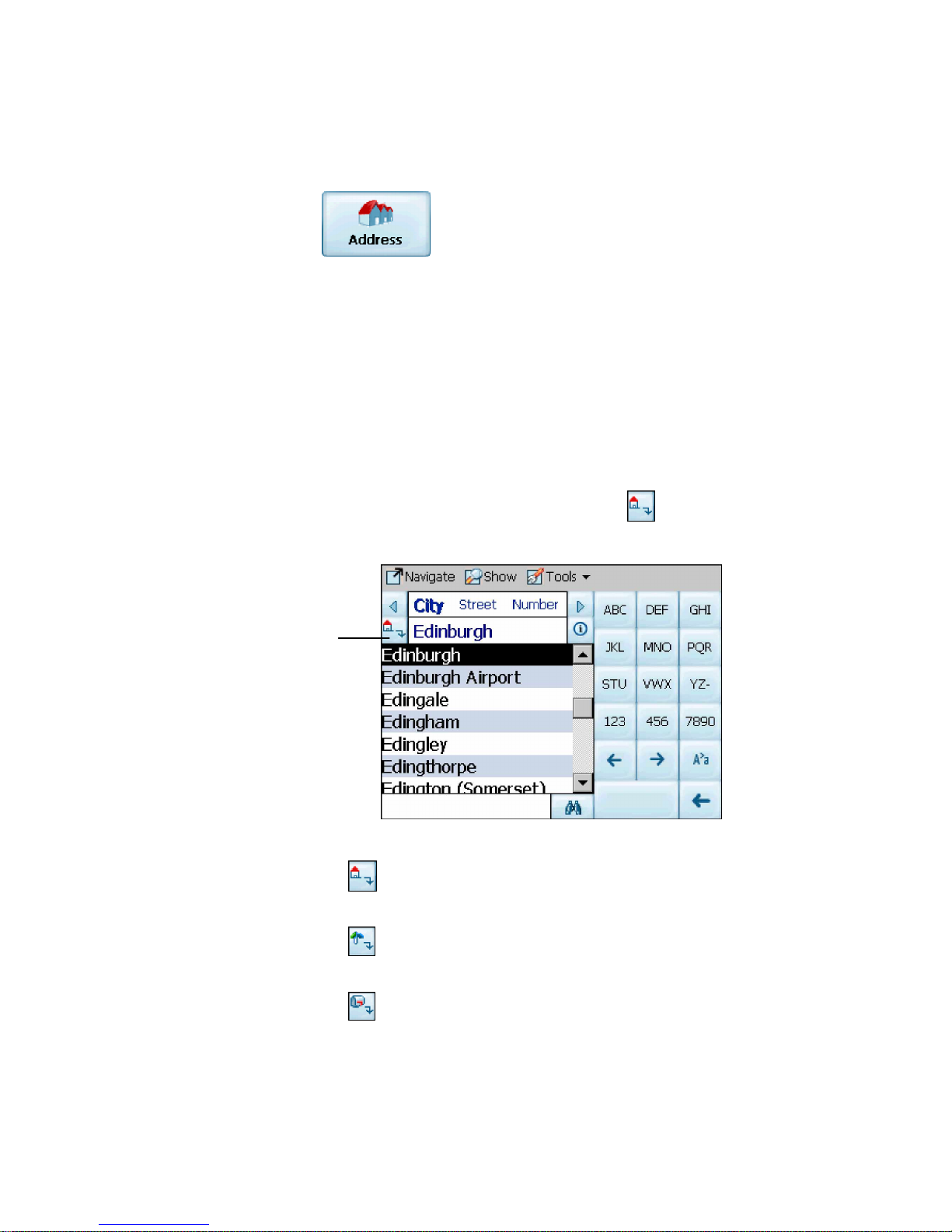
3.4 Navigate To An Address (or Intersection)
When you navigate to an address, there are several wa ys of
defining y our desti nati on. You can navigate to a destination
by selecting an add ress, a zip/pos ta l code, or an
intersection.
The Cross Region Navigation feat ure lets you navigate a
route that extends across more than o ne region. This
feature becomes avail abl e only when you have several
maps installed.
The default order for entering your destination is City ->
Street -> Number, but by clicking on the
button, you can
cycle through the different ways of specifyi ng your address.
Click on this
button to change
your search type.
Figure 4 - Address Search Screen
Lets you search for an address by first entering the
City, then the Street, then the Number.
Lets you search for an address by first entering the
Street, then the City, then the Number.
Lets you search for an address by first entering the
Zip/Postal Code, then the Street, then the Number.
Page 16
Voxtrack 500 Navigatio n Software User Guide
Page 16 of 59
Lets you search for an address by first entering the
Street, then the Zip/Postal Code, then the Number.
Lets you search for an intersection by entering the
City, the first Street, then the intersec ting Street.
For example, to navigate to an address using the City ->
Stree t -> Number se arch order:
1. Press Region if you are navigating a route across
several maps. Highlight your selection from the list of
installed maps. (If only one map is installed, you will
not see the Region option.)
2. Press City and use the ke yboard to enter the first few
characte rs of the city name. The scroll list will upda te
accordingly . You can also change your keyboard from
uppercase to lowercase by pressing the
button.
3. Press Street to display a list of street names for the
selected city. Select the street name by entering th e
first few characte rs or by scrolling down the list (eg:
Birch, Ave).
4. Not all cities/towns are mapped to the street level. In
such cases, the sof twa re will display Street data not
found. You can still navigate to the city as selected.
5. Press Number and ente r the numbe r using the
keyboard.
6. Once you have entered your destination, there are
several options ava ilable on the toolbar found at the
bottom of the screen.
Calculates and displays your route, which
is shown as a blue line on the map.
Shows the destination on the map and
display s its details.
Page 17
Voxtrack 500 Navigatio n Software User Guide
Page 17 of 59
Allows you to add the destination to your
Favorites Folder, or to set it as your Origin.
As you drive, Destinator provides you with turn-by-turn voice
and visual direction s , letting you kno w when your next turn is
coming up until y o u arrive at your d estinati o n.
If you don’t know the entire name of a c ity or street, type in part of the
name and press the
button. This will display a list of all names
that match what you’ve typed in.
For more information on a City, Street or Number click to display
details about the location, such as its city, street name, and latitude and
longitude coordinates .
Note:
Some smaller (sub - ) munic ipa lities may n ot contain s treet data. In such cases,
please choose the larger (super-) municipality displayed in parentheses to search for
these streets . Alternatively, you can change the search order to Stre et>City or
Zip/Postal Cod e>Str eet to find street data for the smaller municipality.
3.5 Navigate To A Point of Interest (POI)
The Points of Interest (POI) list is a collection of potential
destinations of interes t in predefined c ategorie s . POIs are
identified o n the map by various icons (eg: Restaur ants).
POI navigation is especially handy when you need to find a
facility, attraction or amenity by category or type. For
example, you can ask Destinator to guide you to the nearest
bank, mall, hotel, restaura nt , gas sta tion, etc.
Page 18
Voxtrack 500 Navigatio n Software User Guide
Page 18 of 59
The Cross Region Navigation feat ure lets you navigate a
POI route that extends across more than one region. This
feature becomes avail abl e only when you have several
maps installed.
1. From the Destination Menu, press the POI button.
2. Press Region if you are navigating a route across
several maps. Highlight your selection from the list of
installed maps. (If only one map is installed, you will
not see the Region option.)
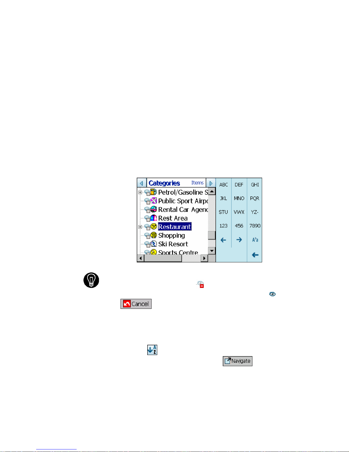
3. Press Categories and highli ght y our selecti on from
the list of POI catego ries. F or ex ample, we can
search for the nearest restaurant.
Figure 5 - POI Categories
At this point, you can display all the items within a category on the
map screen by tapping the
button beside any of the
categories. When selected, the button will appear as
. Press
to return to the map screen.
4. With Restaurants highlighted, tap Items to display a
list of Restaurants in your area. The POIs are listed in
order of distance. To sort them alphabetically, press
the
button.
5. Highlight your choice and click
to calculate
your route. The route is shown on the map as a blue
line from your current GPS position.
Page 19

Voxtrack 500 Navigatio n Software User Guide
Page 19 of 59
6. You can select to preview your destination
on the map, or press
to add the destination
to your Favorites or to set it as your Origin. You can
also select Settings to define your Search Radi us and
Search Center.
As you drive, Destinator provides you wi th turn-by-t ur n voice
and visual directions , letting you know when your n ext turn is
due.
3.6 Navigate To A Favorite
You can select a destination from your list of stored
Favorites. (The next section describes how to save an item
to your Favorites list.)
A Favorite is an address or destination prev ious ly stored by
you for quick and easy retrieval. You can also save, edit or
delete destinations from this folder.
1. From the Destination menu, press the Favorites
button. Your list of Favorites categories is displayed.
2. Highlight My Favor ites and tap Items. A list of stored
items is dis p la yed .
3. Highlight your selection and click
to
calculate your route. The route is shown on the map
as a blue line from your current GPS position.
4. You can also select
to preview your
destination on the map, or press
to edit or
delete your choice, or to set it as your Origin.
As you drive, Destinator provides you wi th turn-by-t ur n voice
and visual directions , letting you know when your n ext turn is
due.
Page 20

Voxtrack 500 Navigatio n Software User Guide
Page 20 of 59
3.7 Save to Favorites
When selecting a Destination which you may use regularly,
you can save it to your personalized F avorites l ist.
1. At the map screen, press the
button to open the
Destination menu.
2. Select and specify your desired destination as
described prev iously, be it from Address, POI,
History or Contacts.
3. To save the location in your Favorites folder, click the
button and select Favorites. The Edit Item
Properties screen is displayed.
Figure 6 - Adding An I tem to Favorites
4. Enter a name and comment that will help you
recognize the item in future.
5. Enter a new category name (eg: Must see) or select
an existing one and press Save.
Your favorite destination has now been stored for future use.
Page 21

Voxtrack 500 Navigatio n Software User Guide
Page 21 of 59
3.8 Navigate To A History Item
History allows you to select an existing destination from a
list of previously travel ed routes. The software automati cal ly
stores the last few destination s in memor y. As each new
route is added to the top of the list, the older destinations at
the bottom are erased.
Figure 7 - History List
1. From the Destination Menu, press the History button
to display your list of previous ly traveled routes.
2. Highlight your selected History item and click
to calculate your route. The route is
shown on the map as a blue line from your current
GPS position.
3. You can also select
to preview your
destination on the map, or press
to add the
destination to your Fav orites or to set it as your
Origin.
Page 22

Voxtrack 500 Navigatio n Software User Guide
Page 22 of 59
3.9 Navigate To A Point on the Map
You can navigate to any point on the map by tapping its
location directly on the map screen. This feature is especially
handy when you want to navigate to a specific point you see
on the map, but you don’t have its street address.
Figure 8 - Map Cursor Dialog
1. Use the stylus to scroll or drag the map to a specific
point, and then tap the desire d locati on.
2. A dialog box displays the address of that point, and
lets you select whether you want to navigate to it,
recalculate your route, add the point to your Favorites,
or set it as your Origin (if you are in Planner Mode).
3. To clear the cursor dialog, just tap the screen agai n.
If you need to reset the point of Origin, tap the map screen
to open the Cursor Dialog, and select Set As Origin. All
new route calculations will use this as the starting point, but
only if you are in Planner Mode. In Navigation Mode, your
current GPS locati on is al way s your Ori gin.
Dialog Box on the
Map Screen
Page 23

Voxtrack 500 Navigatio n Software User Guide
Page 23 of 59
3.10 Trip Planning
Trip planning is useful when you have more than one
destination alon g your route . This process is similar to the
procedures used to enter or select a destination and initiate
navigati on, except that you must be in Planner Mode.
When you press , the Route is calculated in stages, from
the departure point to the first waypoint. Once you’ve reac hed the first
waypoint, the route is reca lculated to the second waypoint, and th en
recalculated to the third waypoint, and so on.
How to Use Trip Planning
Use the following method to plan a trip:
1. Ensure you are in Planner Mode. To do this, press
the
button and cycle to the Settings Menu.
2. Press Route Settings
and select Pl anner
mode.
3. Press the button to save and return to the map
screen.
4. At the map screen, press the
button and select
Trip Planner
from the Destinati on menu.
Page 24

Voxtrack 500 Navigatio n Software User Guide
Page 24 of 59
Note: If this is the first time you are using Trip Planner you will need
to create a Trip Folder in which to store your trip details. You can use any
name. For this example we will be using My tr ip.
5. From the tool bar at the top of the screen, click Tools
and select Add to create a trip folder.
Figure 9 - Adding a Trip Folder
6. Enter the name of your trip folder (e.g. My trip) and
press Save. You can now enter the waypoints of your
trip.
What is a waypoint? A waypoint is a stop or break in your journey, along
a predefined route.
7. Highlight your trip folder, and press Waypoints near
the top of the screen to define your waypoints.
8. From the tool bar at the bottom, click Tools and
selectAdd to define your waypoints.
9. Select the address of your first waypoint – this can be
selected from Address, POI, Favorites or History –
and press
.
10. In the Edit WayPoint Properties screen, you can
change the name or details of the waypoint. Press
Save to add to your trip.
Page 25

Voxtrack 500 Navigatio n Software User Guide
Page 25 of 59
Repeat steps 6 to 9 to enter all the waypoints.
Figure 10 - Trip Planner and Waypoin ts D ia logs
11. Select the Show
button to view the complete
route. The first part of the route is shown as double
blue lines. The remaining parts of the route are shown
in a series of single line vectors.
12. Using
or , you can
change the order of your waypoints to s uit your
purposes.
13. You can also click on Tools > Optimize, which will
automatically sort the waypoints for the most effective
and quickest route.
14. To calculate the route, press Navigate
.
The route is shown as a blue line from your current
GPS position.
* Remember to change back to Navigational Mode. *
See S ecti on 5.7 Route Settings for a description of Navigation
Mode and Planner Mode.
Page 26

Voxtrack 500 Navigatio n Software User Guide
Page 26 of 59
3.11 Avoid Roads
You can specify that certain roads be excluded from your route
calculations. For example, you may prefer to not travel on any
toll roads .
1. From the Destination Menu, press the Avoid Roads
button to display a list of road categories.
Figure 11 - Avoid Roads (Categories)
2. To place restrictions on a desired road category,
highlight the category and p ress
or
to suit your preference. Press to add a new
category .
3. Tap on Items to list all the roads in a highlighted
category. To specify restrictions for a particular road,
highlight i t and press
or . To preview
a highlighted road on the map screen, press the
button and select Show.
Page 27

Voxtrack 500 Navigatio n Software User Guide
Page 27 of 59
Figur e 12 - Avoid Roads (Items)
4. Once you have specified your road restrictions, press
to return to the map screen.
Page 28

Voxtrack 500 Navigatio n Software User Guide
Page 28 of 59
4
Options
4.1 Introduction
There are various route and map options available from the
Options Menu.
This chapter contains the following topics:
• Showing your Route
• Displaying Directions
• Canceling your Route
• Recording and Playing Back a Route
• Switching Maps
• Selecting Travel Mode
• Getting Help
Page 29

Voxtrack 500 Navigatio n Software User Guide
Page 29 of 59
4.2 The Options Menu
The Options Menu provides choices for displaying your route,
displaying your driving directions, canc eling a route, playing
and recording a route, switching maps, selectin g your mod e of
travel, and getting help with basic navigation.
4.3 Show Route
This option displays your route on the map screen in its
entirety, plus det ails s uch as the address of and distanc e to
your destination, the ETA, and the ETR.
4.4 Driving Directions
This function displays a visual list of your route, dista nces to
each manoeuvre, and street na mes . By using the scroll bar on
the right hand side, you can scroll through the e ntire route .
Tapping on the manoeuvre twice displays th at part of the route .
Voice and visual prompts (dis played at the top of the screen)
are provided at varying interva ls to indicate your next turn or
change of direction.
Page 30

Voxtrack 500 Navigatio n Software User Guide
Page 30 of 59
Figure 13 - Driving Directions
The Driving Directions screen also gives you several route
options:
Show Route
Displays your route on the map sc reen in its
entirety, plus details such as the address of your destination,
the ETA, and the ETR.
Cancel Route
Cancels and clears the route from the map
screen.
Show Turn
Displays the highlighted portion of the list on the
map screen, including the street name, distance to it, and an
arrow diagram to ind icate the turn. You can also use the
Prev and Next arrows to scroll to the previous or next turn.
Avoid Turn
Will recalculate your route to exclude this
particular turn or manoeuvre.
Page 31

Voxtrack 500 Navigatio n Software User Guide
Page 31 of 59
4.5 Turn By Turn
This view indicates the distance to your next turn, and the
name of the next street immediately after completing the
previous turn.
Voice and visual prompts are displayed at varying intervals to
indicate your next tur n or change of directio n.
Figure 14 - Turn by Turn Dialog
4.6 Cancel Route
Cancels and clears the route from the map scre en.
4.7 Play
This feature allows you to record your route as you’re traveling,
and then to play it back on the map screen at a later time.
From the Play/Record screen, you can record a route, play
back a route, change the speed of the playback, and delete
Page 32

Voxtrack 500 Navigatio n Software User Guide
Page 32 of 59
recordings . Pressing returns you to the map
screen.
4.8 Switch Maps
This feat ure lets you s witch between your maps. The Switch
Maps screen also displays details a nd version numbe rs of your
maps, and allows you to delete maps.
4.9 Travel Mode
You can further define your route according to whether you are
traveling by car or on foot. This button lets you switch to
Pedestrian Mode or Vehicle Mode. In Pedestrian Mode, the
navigation radius is restricted to 10 kilometres (6 miles).
4.10 Help
This button launches an abbreviated help file with basic
navigati onal definiti ons and instructions.
Page 33

Voxtrack 500 Navigatio n Software User Guide
Page 33 of 59
4.11 About
Displays software version and details about your Destinator
application.
Page 34

Voxtrack 500 Navigatio n Software User Guide
Page 34 of 59
5
Settings
5.1 Introduction
You can easily change the defaul t settings of m aps, views
and route parameters to suit your personal preferenc es.
This chapter contains the following topics:
• GPS Status
• Home Button Settings
• General Settings
• Map Settings
• Route Settings
• Alert Settings
• Visual Notifications
• Look & Feel
Page 35

Voxtrack 500 Navigatio n Software User Guide
Page 35 of 59
5.2 The Settings Menu
The Settings Menu allows you to change the settings which
determi ne how your route i s calcul ated or displayed.
5.3 GPS Status And Settings
Destinator uses GPS signals to pinpoint your location. In
Navigation mode, the software automatically acquires GPS
signals and constant ly updates your vehicle's loca tion and
position. The GPS may take a few minutes to find its curren t
location initially. For best results, ensure that the GPS has a
clear view of the sky.
Figu re 15 - GPS Status Screen
To view your GPS configuration, click on the
button. You can access this button via the Settings Menu >
Page 36

Voxtrack 500 Navigatio n Software User Guide
Page 36 of 59
GPS Status, or by clicking on the button on the map
screen.
Figure 16 - GPS Settings Dialog
GPS Settings Configuration menu:
1. COM Port - Defines the Communications Port.
2. Baud Rate - Transmission rate of data.
3. Protocol - Default is NMEA.
Find GPS – Searches for and locates the GPS signal.
Set GPS - Sets the GPS Configurati on.
Press the button to save your select ions and return to the
GPS Satellite graphic screen.
Page 37

Voxtrack 500 Navigatio n Software User Guide
Page 37 of 59
5.4 Home Button Settings
The Home Button Settings button lets you define an address
or POI as your home destination. Whenever you want to
navigate to your home destination (for example, the n eares t
gas stat i o n) , pr ess the
button.
In the Home Button Settin gs screen, select either POI Mode
or Address Mode to set your de sire d destination.
Figure 17 - Home Button Settings Screen
Press the
button to save and retu rn to the map screen.
Now, when you press the
button, Destinator will
automatically calcu late a route to this destination.
5.5 General Settings
The General Settings sc reen allows you to choose the unit
of measurement for your route.
Page 38

Voxtrack 500 Navigatio n Software User Guide
Page 38 of 59
Figure 18 - General Sett ings Dialog
All distances are displayed in imperial or metric units .
1. Imperial (Miles and yards)
2. Metric (Kilometers and meters)
Press the
button to save your selection and return to t he
map screen.
5.6 Map Settings
The Map Settings screen let s you customize your map
display.
Figure 19 - Map Settings Dialog
Map Orientati on
Forward is up – orients th e map so that your forward
direction is always at the top.
Page 39

Voxtrack 500 Navigatio n Software User Guide
Page 39 of 59
North is up – orients the map so that north is alwa ys a t the
top.
Zoom Mechanism
Automatic Zoom – ensures that the zoom will return to its
previous lev el afte r seve ral seconds o f inact ivity.
Map Font
Use large labels – increases the size of street names to
make the map easier to read.
Press the
button to save your selections and return to the
map screen.
Page 40

Voxtrack 500 Navigatio n Software User Guide
Page 40 of 59
5.7 Route Settings
The Route Settings sc reen lets you choose the parameters
for route calculation.
Figure 20 - Route Settings Screen
Routing Mode
Navigation Mode – Provides vo ic e instructions as you drive.
This mode is the one you will use most frequently. Destinator
uses the satellit e-based global posi ti oning system (GPS) to
constant ly detect your curren t pos ition. As you drive, your
location is compared to the destination you have chosen and
you will be constantly provided with accurate driving direc tions .
Even if you accidentally drive off c ourse, Destinator will direct
you back on track.
Pla nner Mod e – Displays a route on the map.
You set an origin and a destination, and Destinator displays a
map that shows you the route. In this mode of operation, the
satellite-based global positioning system (GPS) is not used.
Your current position is not detected and Destinator does not
keep track of your driving progres s . Use Planner Mode fo r trip
planning.
Page 41

Voxtrack 500 Navigatio n Software User Guide
Page 41 of 59
Route generation
Quickest route – Destinator calculates the route by picking
the shortest distance and highes t speed limits.
Shortest route – Destinator ca lculates the route by picking
the shortest distance.
U Turn Usage
U Turn enabled - If you select this option , the route wil l be
calculated by including any U Turns that are needed. If
you clear this option, the route will be calculated without
any U Turns. (This feature is included because some
drivers prefe r not to make U Turns.)
Note: Route generati on excludes any detours, stops or del ay s along the
route.
Press the
button to save your selection s and return to the
map screen.
5.8 Alert Settings
This screen displays warni ngs and alerts which, when
selected, will provide v oice prompts .
Figure 21 - Alert Settings Dialog
Voice Prompts
Page 42

Voxtrack 500 Navigatio n Software User Guide
Page 42 of 59
1. Speed Limit - Gives you a voice prompt when your car
exceeds the speed limit on this section of the road.
2. Route Recalculation - If you deviate from the original
route, Destinator automatically recalculates a new route
and updates ETA and distanc es.
3. Low Signal - Warns that you are in an area of low GPS
signal.
4. GPS Not Found - Alerts you if the GPS signal is lost, or
if power is removed from the GPS receiver.
5. Drive Carefully - Friendly reminder at the start of each
journey.
Press the
button to save your selections and return to the
map screen.
5.9 Visual Notifications
The Visual Notificati ons screen lets you choose how
Destinator notifies you of your upcoming turns.
Figure 22 - Visual Notifications Screen
Page 43

Voxtrack 500 Navigatio n Software User Guide
Page 43 of 59
1. Text – Visual notification is displayed in written form.
2. Symbols – Visual notification is displayed in pictorial
form (as an arrow diagram).
3. None - No visual prompts are displa yed.
Press the
button to save your selections and return to the
map screen.
5.10 Look & Feel
The Look & Feel screen allows you to customize the sound
and appearance of Destinator.
Figure 23 - Look & Feel Screen
Voice Prompts – Default or change to different voice.
Skin – Default skin or different s kins, if available.
Press the
button to save your selections and return to the
map screen.
Page 44

Voxtrack 500 Navigatio n Software User Guide
Page 44 of 59
6
Changing Map Views
6.1 Introduction
You can change your view of the map , and the way in which
the map is displayed on the screen.
This chapter contains a description of the following topics:
• How to Zoom and Scroll
• Types of Views
• Day or Night Mode
Page 45

Voxtrack 500 Navigatio n Software User Guide
Page 45 of 59
6.2 How to Zoom and Scroll
Figure 24 - Main Map Screen
With Automatic Zoom selec ted (Settings Menu > Map
Settings button) you can use the zoom buttons to override
the auto zoom, but the zoom will return to its previous level
after several seconds of inactivity.
When Automatic Zoom is not selec ted , you can zoom in or
zoom out manually and it will remain at that level.
You can scroll the map by holding your stylus on the screen,
and dragging the image in any direction.
Page 46

Voxtrack 500 Navigatio n Software User Guide
Page 46 of 59
6.3 Types of View
The button on the map screen toggles between 4 types
of views: 2D, 2D Night, 3D and 3D Night. The icon indicates
the next view to be displayed.
2D View
The 2D view is a straight-for ward two-dim ensional vi ew.
This is the default map view. In this view, the map is
dynamically updat ed, and allows for manual panning and
zooming.
2D Night View
This is a high contrast, two-dimensional view, optimized for
night driving or adverse weather conditions. The map is
dynamically up dated, and all ows for manual panning and
zooming.
Figure 25 - 2D Night View
The route, start point and destination (out lined in blue) are
clearly visible under a variety of weather and driving
conditions.
Page 47

Voxtrack 500 Navigatio n Software User Guide
Page 47 of 59
3D View
The 3D view is a simplified three- dim ension al view showi ng
the map in a basic 3D relief. It shows the b asic relief
(outline) and deta ils of the surrounding roads an d general
area.
Figure 26 - 3D View
3D Night View
The 3D night view is a simplified three-dimensiona l view w ith
high-contras t colorization optimized for night driving or
adverse weather conditions.
Figure 27 - 3D Night View
Current
location
Current location
Page 48

Voxtrack 500 Navigatio n Software User Guide
Page 48 of 59
7
Auto & Favorites Alerts
7.1 Introduction
An Automatic Alert refers to an item that you can co nfigure
so that Destinator will alert you when you are within a
certain distan ce of the item’s locati on. You can confi gur e two
distances for each Automatic Alert. Destinator will first alert
you when you are within the first distance and then alert you
when you are within the second distance. Automatic Alerts
must be stored in either one of three predefined cat egories Auto Alerts 1, Auto Alerts 2, and Favorites Alerts.
Page 49

Voxtrack 500 Navigatio n Software User Guide
Page 49 of 59
7.2 Configuring Auto Alerts Category
Note that this configuration is applied to all items in the
category.
1. From the Destination dialog, select Favorites.
2. Highlight the Auto Alerts folder you want to configure
and select Edit… from the Tools menu in the lowerrigh t corner .
3. To enable both alerts, check both boxes. Or, you can
disable one of the alerts by clearing the box next to it.
If you configure two alerts, the first one must have a
greater distance than the second one.
4. From the pull-down menus, select a distance for each
enabled alert. Destinator will alert you when the
distance between your curren t trav eling position and
the location of the alert equals the distance you enter
here.
5. Close the Edit menu.
6. To display the map position of items in the Auto Alerts
category, check the box to the left of the category
name, just as you woul d to display map posi ti ons of
items in any other categor y.
7. Select Save to complete the configuration.
7.3 Configuring Auto Alerts Items
You can change the name, comment, and category of any
item in Auto Alerts 1 or Auto Alerts 2. However, note that if
you change the category of an item to something other than
Auto Alerts 1 or Auto Alerts 2, it will no longer function as an
auto alert. Only those items in categories A uto Alert 1 and
Auto Alert 2 will function as automatic alerts.
1. From the Destination dialog, select Favorites to
display all the categories.
Page 50

Voxtrack 500 Navigatio n Software User Guide
Page 50 of 59
2. Highlight a category and then select Items from the
upper menu bar. All items in the category are
displa yed.
3. Highlight the alert you want to edit and select Edit
from the tools menu in the lower right corner.
4. You can change the name, comment, and category of
an item. You cannot change any other information .
Note that if you change the category, the item will be
moved out of the current category. Only those items
found in either Auto Alerts 1 or Auto Alerts 2 will
actually function as auto alerts.
5. Close the edit window.
7.4 Favorites Alerts
From the Favorites folder, you can a dd a new Catego ry
called Fa vorites Alerts. These alerts function the same
way as Auto Alerts, but can be used specifically for ite ms
from your list of Favorites, such as your favorite restauran ts
and places of in terest
.
Page 51

Voxtrack 500 Navigatio n Software User Guide
Page 51 of 59
Glossary
This glossary describes te rms and abbreviations used with Destina tor.
Abbreviation Name Description
COM PORT
Communica tions
Po rt
In Computer systems, the name of a
seria l communications po rt - Eg: COM1,
COM2, COM3, and COM4.
EULA
End-User License
Agreement
Is a leg al contract between a softwar e
application author or publisher and the
user of that application. The EULA, often
referred to as the "softwar e licen se," i s
similar to a rental agreement; the user
agrees to pay for the privilege of using
the softwa re, and prom ises the software
author or publisher to comply with all
restrictions stated in the EULA.
ETA
Estimated Time of
Arrival
The estimated time to complete the
journey, if we where to leave now.
Excluding any detour s, stop s or delays
alo ng th e rout e.
ETR
Estimated Time
Remaining
The estimate d time remaining to
complete the route . Does not allow for
any del ay s.
FAQ
Frequently Asked
Questions
A list of Frequently Asked Question s with
Answers.
GPS
Global Positioning
System
The GPS (Global Positioning System) is
a "constellation" of 24 well-spaced
satellites that orbit the Earth and make it
possible for Vehicl es/ people / asset s
enab led with GPS receivers to pinpoint
their location.
Lat
Latitude
An imaginary parallel cir cular lin e (E ast /
West) around the e arth, the same
distance, north or south from the equator
– expressed in degrees.
Lo ng
Longitude An imaginary circular li ne on the surfa ce
of the earth passing through the North
and South poles at right angles to the
equator - expressed in degrees.
Orbit
Orbital path of a
Satellite
Path or trajectory of a body through
space. A GPS satellite trace s out an
orbit about the earth.
POI
Point Of Interest A place or item of interest along the
selected route.
Page 52

Voxtrack 500 Navigatio n Software User Guide
Page 52 of 59
Abbreviation Name Description
Sat
Satellite
See also GPS
A man-made ob ject , or device tha t orbits
the earth. Eg: a GPS Satellite whi ch
orbits the earth in a fix patter n, hei ght
and speed
SD
Secure Digital
memory card
A Secure Digital (SD) card is a tiny flash
memory card used to make data storage
portabl e among various devices.
TTD
Total Time
Duration
The projected total ti me the trip is
calculated to take - does not allow for
any detours or other delay s.
Page 53

Voxtrack 500 Navigatio n Software User Guide
Page 53 of 59
Appendix A – Device Settings
Figure 28 - Main Screen
You can change the default us er settings for the device by
pressing SETTINGS on the main screen.
Figure 29 - Settings Menu for Device
Opens the Settings Menu for
your device
Power Settings – See Figure 31.
Language Settings –
See Figure 34.
Syste m Informati on –
See Figure 35.
Time Setti ngs – See
Figur e 33.
Backlight Setti ngs – See
Figur e 32.
Returns you to
the Main Screen.
Volume Setting – See
Figur e 30.
Opens the navigation
softw are - Destinat or
Page 54

Voxtrack 500 Navigatio n Software User Guide
Page 54 of 59
Volume Setting
Figure 30 - Volume Setting Screen
The Volume Setting scree n lets you adjust th e volume of the
device.
Press
to return to the Settings menu.
Power Settings
Figure 31 - Power Settings Screen
The Power Settings sc ree n indicates the battery status of the
device.
Press
to return to the Settings menu.
Page 55

Voxtrack 500 Navigatio n Software User Guide
Page 55 of 59
Backlight Settings
Figure 32 - Backlight Settings Screen
The Backlight Settings screen lets you select how bright the
screen will be. You can save power by selecting how long
the backlight will stay on before it dims.
Press
to return to the Settings menu.
Time Settings
Figure 33 - Time Settings Screen
The Time Settings scree n allows you to select your time
zone, and lets you set the date and t ime.
Press
to return to the Settings menu.
Page 56

Voxtrack 500 Navigatio n Software User Guide
Page 56 of 59
Language Settings
Figure 34 - Language Settings Screen
The Language Settings sc ree n lets you select the languag e
that will be used for screen displays and voice prompts.
Press
to return to the Settings menu.
System Information
Figure 35 - System Information Screen
The System Information screen display s the software
version of your Destinator application and information about
your device. You can also calibrate t he position of the
display.
Press
to return to the Settings menu.
Page 57

Voxtrack 500 Navigatio n Software User Guide
Page 57 of 59
2
Index
2
2D View..............................................46
3
3D View..............................................47
A
Address..............................................15
Known............................................14
B
Button
Descriptions ...................................11
Plan................................................13
C
City
Find................................................16
Name .............................................16
Com Ports..........................................36
D
Device Settings..................................53
F
Favorites............................................20
G
Glossary.............................................51
GPS
Baud Rate......................................36
Check.............................................36
Current Position Icon......................11
Not Found ......................................42
Ports...............................................36
Protocol..........................................36
Settings..........................................35
Signal.............................................42
Status.............................................35
H
Help .....................................................7
History................................................21
I
Icons................See Button Descri ptions
Index..................................................57
K
Known Address..................................14
M
Map....................................................46
Information.....................................39
Settings..........................................39
N
Navigati on Mod e
Origin Icon......................................14
New Origin.........................................22
O
Origin.................................................14
Planner Mode.................................40
P
POI...............................................17, 22
Point Of Interest.................................17
Point On the Map...............................22
Prompt
Voice..............................................29
Q
Quickest route....................................41
R
Recalcul ation of Route.......................42
Route
Defining..........................................10
Planning of.....................................10
Quickest.........................................41
Page 58

Voxtrack 500 Navigatio n Software User Guide
Page 58 of 59
Recalculation..................................42
Setting............................................10
Shortest..........................................41
Zoom.............................................. 45
Route generation................................41
S
Save
Favorites........................................20
Set
New Origin .....................................22
Settings
Alert................................................41
General..........................................38
GPS ...............................................35
Map Orientation..............................38
Route .............................................40
Units...............................................38
Shortest route.....................................41
Speed ................................................42
Start Point..........................................22
Street
Find................................................16
Name .............................................16
T
Trip.....................................................23
Trip Planning......................................23
V
View
2D..................................................46
3D..................................................47
Changing Map View.......................44
Types.............................................46
Z
Zoom..................................................45
Automatic.......................................39
Page 59

www.voxson.com
 Loading...