

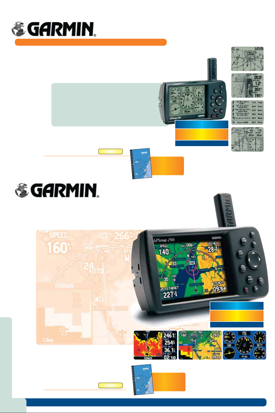
GPSMAP196
A VERSATILE NAVIGATOR FOR AIR, LAND, AND SEA.
This WAAS-capable unit has detailed moving map graphics, HSI steering guidance, a Jeppesen database,
and all the other pilot-friendly features you'd expect from Garmin. The unit's 12-level greyscale display
offers exceptional resolution, with extremely fast map redraws and scrolling. Steering guidance is clearly presented through a graphic HSI with VNAV, with extended runway centerlines. An automatic logbook
also calculates your flight time and automatically records departure and arrival locations. The GPSMAP
196 compromises nothing in its versatility, going from cockpit to land to water. In addition to the built-in
Garmin basemap, the GPSMAP 196 accepts most of Garmin’s MapSource® products.
Panel page graphically displays flight information
•
Logbook feature automatically records departure
•
airports, arrival airports, and flighttime, all of which can
downloaded to free Flightbook software
Extended runway centerlines display on a moving map
•
Split-screen moving map and HSI display
•
Aviation, Land, and Water modes.
•
Large (3.8” diagonal) 12-level greyscale display
•
Package includes: GPSMAP® 196 receiver; Atlantic Autoroute basemap; Free single
Jeppesen® update; Yoke mount; Dash mount; PC interface cable; Cigarette lighter
adapter; Low-profile remote GPS antenna; Owner’s manual; Quick reference guide
GARMINGPSMAP196
GPSMAP196
£421.95
G
CHECK OUR LATEST ON-LINE PRICE
A
FREE
UK En-Route Guide
with every GPS
Worth £15.95
WEBCHECK
£421.95
GPSMAP296
The GPSMAP 296 builds on the tradition of Garmin aviation handhelds with terrain cautions and alerts, chartlike topographic data, and a transparent navigation arc view for course, speed, and distance information leading the list of advances. The GPSMAP 296 also features USB data transfer, faster processing speed, and a
rechargeable lithium-ion battery pack. The GPSMAP 296 delivers terrain awareness in an intuitive Terrain mode
and the unit combines GPS position, GPS altitude and topographical mapping to give pilots a vivid depiction of
potential terrain hazards.
WAAS-capable GPS receiver for enhanced lateral/verti-
•
cal guidance
Crisp, high-resolution display (480 x 320 pixel count),
•
256-colour TFT display (3.8 inches diagonally)
5.7” W x 3.2” H x 1.9” D unit dimensions
•
Up to 15 hours battery life (typical use backlight
•
conditions); 8 hours full backlight brightness
Rechargeable lithium-ion battery pack
•
Road and marine modes for easy navigation in a
•
vehicle or boat
Detailed basemap includes major roads, borders,
•
rivers, lakes, and tide stations
Accepts data from Garmin’s MapSource products
•
(City Select for driving, BlueChart for saltwater, and
Recreational Lakes with Fishing Hot Spots® for
freshwater)
GPSMAP296
Waterproof
•
50 reversible routes (300 waypoints each), 15 saved
•
tracks (700 trackpoints each), TracBack® technology,
3000 waypoints with graphical icon identification
Voice prompt guidance when the 12-volt / speaker
•
cable is connected
Separate serial and USB interfaces; 2 RS-232 serial ports
•
WEBCHECK
£779.95
CHECK OUR LATEST ON-LINE PRICE
Package includes: GPSMAP® 296 receiver; Atlantic
Autoroute basemap; Adjustable yoke mount; Automotive
mount; Cigarette-lighter adapter; AC power adapter; USBPC interface cable; Low-profile remote GPS antenna;
Carrying case; Free Jeppesen® update certificate; Trip &
Waypoint Manager software; Owner’s manual; Quickreference guide
GARMINGPSMAP296
£779.95 G
4
A
FREE
UK En-Route Guide
with every GPS
Worth £15.95
All prices include UK VAT where applicable
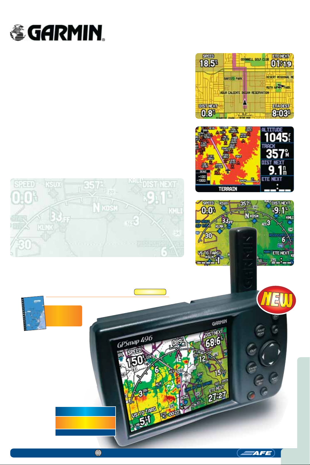
GPSMAP496
Terrain awareness, Obstacles, VRPS, ATZs
and MATZs, Private airfields and helisites,
airspace declutter, aural alerts and much
more…
GPS mapping imagery is taken to a new level with the enhanced detail and best-ever
resolution of the Garmin GPSMAP 496. For UK users VRP’s (Visual Reference Points)
have been added to the system - each can be searched and navigated to in two button presses. Obstacles have also been added, each can be interrogated simply by
moving the cursor over it to display information. Aerodrome Traffic Zones (ATZs) and
Military Aerodrome Traffic Zones (MATZs) a feature of the new European database, as
are private airfields and heliports. Another new feature is “Airspace Declutter”, which
allows the user to select an ‘upper’ altitude so that the 496 display will only show the
airspace at or below that altitude. If the pilot goes above the set threshold then all
airspace comes back onto the display. Then there’s “Smart Airspace”. This means that
the boldness changes for the airspace depending on your altitude, this offers better
situational awareness on the display to view impending airspace.
The new features of the GPSMAP 496 don’t end there. The GPSMAP 496 will output
VOICE COMMANDS, similar to those found in high TAWS (Terrain Awareness Warning
Systems). So, not only does the unit alert the pilot visually to terrain or obstacles via
the thumbnail in any page or on the dedicated terrain/obstacle page, it also gives
aural alerts to a headset or to an Audio panel or Intercom.
GPSMAP496
WAAS-enabled, 12 parallel channel GPS receiver
•
Display Size: 3.75” Diagonal, 480 x 320 pixels
•
256-colour, sunlight readable TFT display with adjustable backlight
•
Unit Dimensions: 5.7” W x 3.2” H x 1.9” D
•
Smart Airspace™ feature makes it easier to identify what airspace lies ahead
•
Built-in Jeppesen database with terrain and obstacle databases
•
Terrain/obstacle display with pop-up warnings
•
Preloaded with detailed City Navigator NT street maps and POI database
•
Voice-prompt road guidance( when the power/speaker cable is connected)
•
Accepts standard Garmin data cards and pre-programmed data cards
•
Rechargeable lithium-ion battery offers 5 to 15 hours of use
•
Water resistant
•
The GPSMAP 496 package includes: GPSMAP 496; Preloaded City Navigator® NT
Europe (full coverage); Free single Jeppesen update; GXM™ 30A smart antenna; Lowprofile remote GPS antenna; Auto mount; Yoke mount ; Friction mount; 12-Volt automotive adapter cable with speaker; Wall charger; USB interface cable; Carrying case;
Owner’s manual; Quick reference guide.
GARMINGPSMAP496
A
FREE
UK En-Route Guide
with every GPS
Worth £15.95
£1,445.95
G
WEBCHECK
£1,445.95
CHECK OUR LATEST ON-LINE PRICE
0161 499 0023
www.afeonline.com
5
 Loading...