

Page 1

GPS Camera&Navi Tracker
Instructions
TRACKERS
TAG 702 / 707 / 708 / 710
1250 S. Alhambra Circle #10
Coral Gables, FL 33146
Page 2
1 GPS Tracking System Introduction
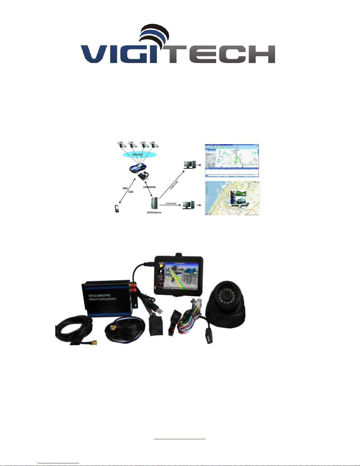
GPS Camera Tracker integrates GPS and GSM functions, which could send vehicle location and
status to mobile and Internet. It can track the vehicles remotely and transmit image of the vehicle
to Internet through camera. The system structure is as below:
2 Product Description TAG 702/707/708/710
2.1 Specification
GSM module:
Band:850/900/1800/1900MHz
Max RF Output: 33.0dBm±2dBm
Dynamic Input Range: -15 ~ -102dBm
1250 S. Alhambra Circle #10
Coral Gables, FL 33146
Page 3

GPS module:
GPS chip set: SiRF Star III
Frequency: L1, 1575.42 MHz
Number of Channel: 20
Interface:
1 Camera interface
1 extend R232 port
1 A/D Port
general I/O Ports
1 Microphone interface
Battery:
Voltage:3.7V
Charge:<4.2V
Li-ion: 200~850mAh
Input Voltage: DC 9~36V
Operating Temperature:-45~65 ℃
2.2 Features:
1. Use Google map, Global free
2. Take photo of the vehicle, and Image transmit to internet.
3. Fuel Check / monitor
4. Real-time locating / inquiry
5. SOS button/Power-cut Alarm
6. Listen by telephone
7. E-fence/Over-speed Alarm
8. Compatible original anti-theft
9. Remote control engine
1250 S. Alhambra Circle #10
Coral Gables, FL 33146
Page 4
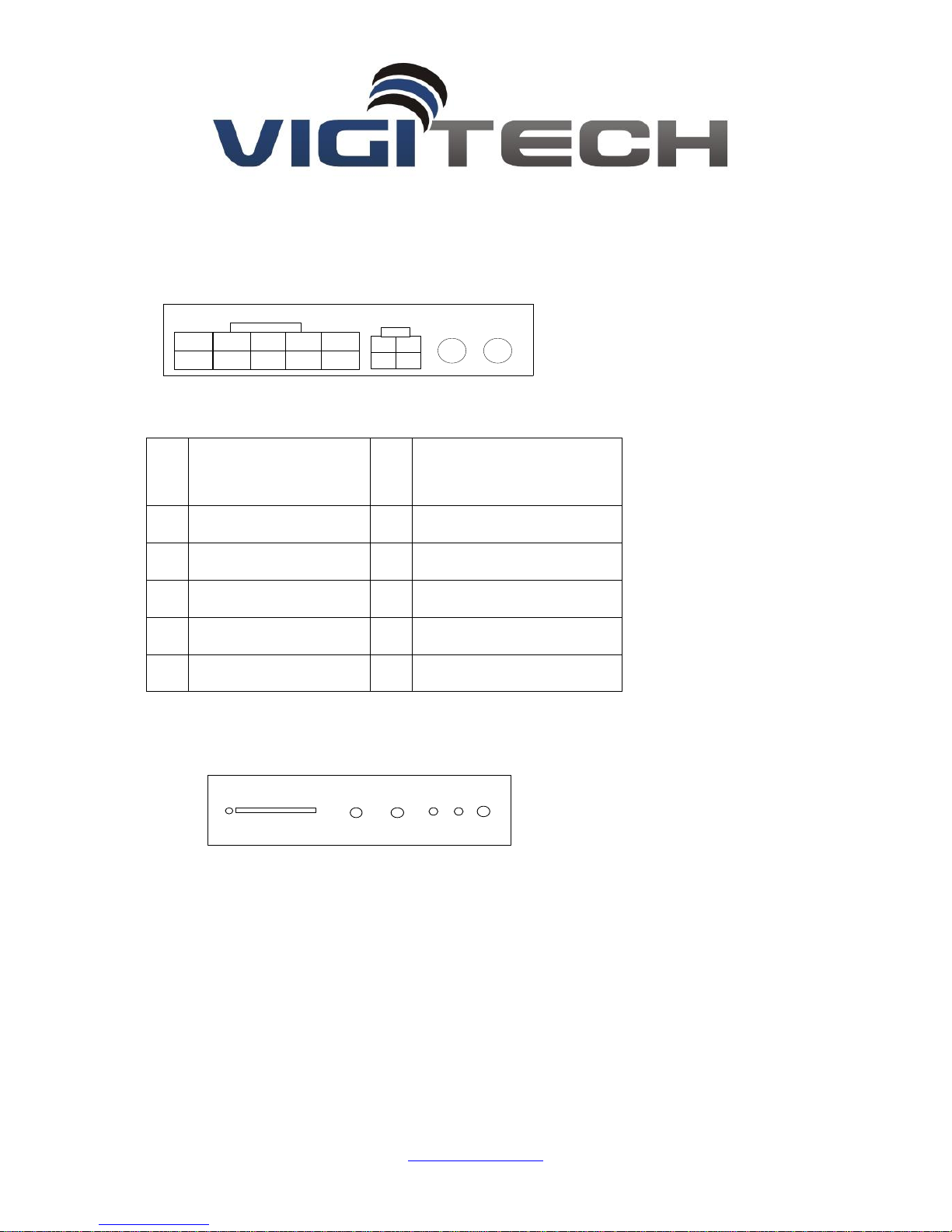
3 Installation Instructions
GPS1GSM
132
4
DATA1
DATA2
6
2
7
38495
10
No
.
Description
No
.
Description
1
DC+ (9~36V)
6
GND
2
Fuel check line
7
SOS button
3
GND 8 Extend port1(Assist alarm)
4
ACC
9
Extend port2
5
Engine cut_off control
10
Extend port3
SIM
MIC
PHONE
LED1 ResetLED2
3.1 Interface
DATA1
DATA2:
Camera port
1、SIM: Port for SIM card
2、PHONE: Connect to Microphone
3、MIC: Connect to earphone
4、LED1: Power light
5、LED2: Status light
6、Reset
1250 S. Alhambra Circle #10
Coral Gables, FL 33146
Page 5
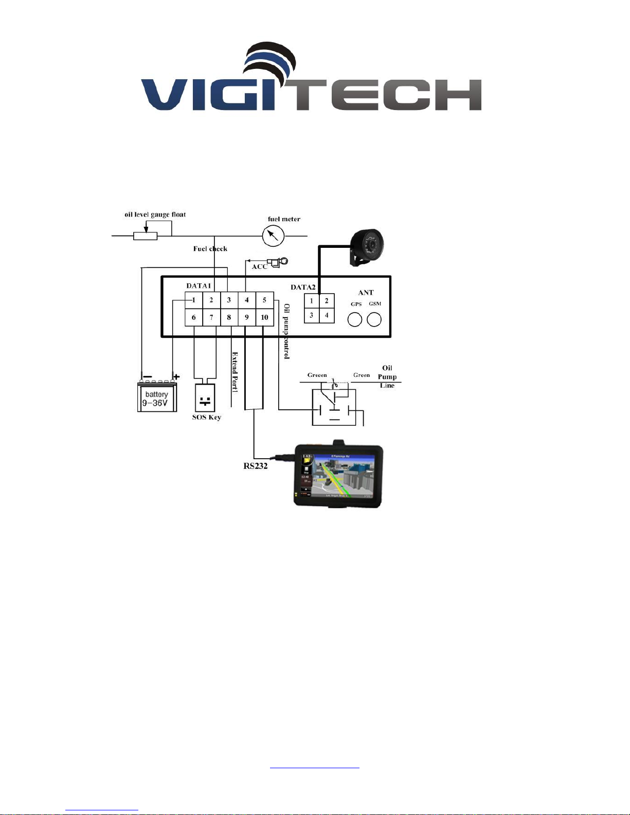
3.2 Installation Figure
3.3 Installation and Test:
Please test after installation. If you don’t need some functions, you can disconnect
corresponding interface. Please make sure ACC, DC, GND installed correctly. Otherwise, the device
cannot work. Please check the device status through signal light after power on:
LED1 is off indicates there is no power.
LED2 flashes for one second which indicates GSM registers successfully.
LED2 flashes three seconds once which indicates GPS is obtaining orientation
LED2 is on which indicates work successfully that GSM has registered and GPS has obtained
the orientation.
If LED 2 is on 0.1 second then off 0.1 second for more than 3 minutes, please make sure SIM
card inserts well. Without SIM card, the device cannot work.
1250 S. Alhambra Circle #10
Coral Gables, FL 33146
Page 6
4 SMS Operation Instruction
SMS Format: A******,cmd,param1,param2…
1. ******is the password, Initial Password is 000000
2. cmd is the command ID.
3. Param is the command parameter. Different cmd use different parameters. All the
parameters must use half-angle symbol. Wrong SMS format or wrong password, it will not
respond.
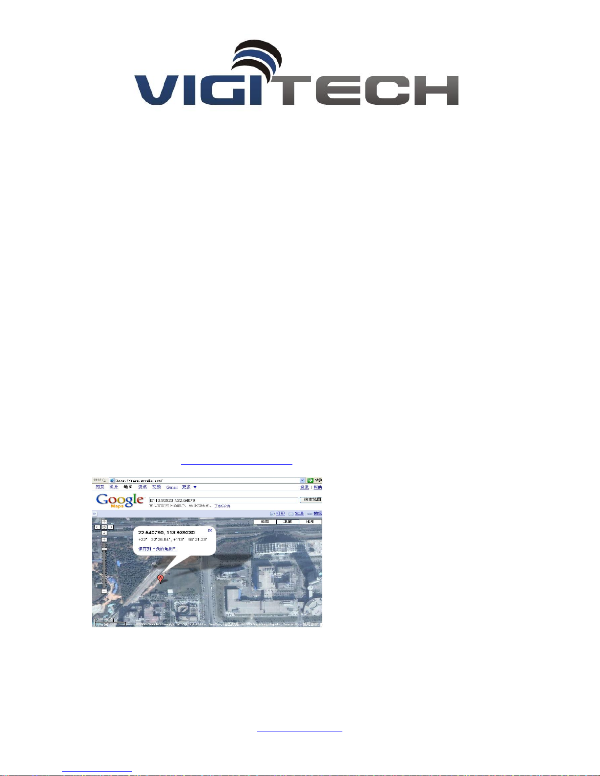
4.1 Location Enquiry (000)
Message format: A******,000
e.g. A000000,000
Reply: Longitude E113.93923 Latitude N22.54079 08-10-20 17:38:30,
User could enquiry in HTTP://maps.google.com.
4.2 Change Password (001)
Message format:A******,001,New Password
1250 S. Alhambra Circle #10
Coral Gables, FL 33146
Page 7

e.g. A000000,001,123456
Note:000000 is the old password ,123456 is the new password.
Reply:Set Password OK!
4.3 Real-time return setting (002)
Message format:A******,002, XXX
XXX=0 is for STOP, value of XXX is within [15~64800] seconds.
e.g. A000000,002,30
Message replied after successful setting: Set time interval (30) OK!Message contains position
information will be sent in every 30 seconds after successful setting.
4.4 Alarm/Listen Number setting
Message format:A******,003,P, TelNumber
P=1 is for SOS and listen
P=2 or 3 is the second\ the third listen number.
e.g. A000000,003,1,136xxxxxxxx
Message replied after successful setting:Set Telephone OK!
Keep pressing SOS button for 2 seconds. The device will send emergency SMS and dial the number
you set as SOS number.
Reply: SOS Pos: Longitude E114.04577 Latitude N22.32405 08-10-20 17:38:30,
If you dial with your listen number, it can be connected automatically after the 7th ring. Then you can listen the voice in
the vehicle.
4.5 Over-speed Alarm Setting (005)
Message format: A******,005,XXX
XXX=[000,200] (unit: km/h)XXX=00 is close the function.
1250 S. Alhambra Circle #10
Coral Gables, FL 33146
Page 8

e.g. A000000,005,020
Message replied after successful setting: Set Over speed (20) KM OK!
If the vehicle is over speed you set, it will send alarm SMS to SOS mobile number. 20 KM/H Over
speed!
4.6 e-Fence Setting(006)
Message format:A******,006,XX
XX =[00-50] (Unit:100m) .
When XX=0, e-Fence is OFF. And the maximum limited value of XX is 50*100=5000m. e.g.
A000000,006,10
Reply: Set Distance (1000)M OK!When user is out of the bound region (e.g. 1020m), a prompt
message will be sent to the user: 1020m is further than 1000m!
4.7 Engine Cut-off Setting (007)
Message format: A******,007,X
X=0 cut off engine , x=1 resume engine, For security, this command will execute when the speed
less than 20Km / h or the ACC is off .
e.g. A000000,007,0
4.8 Fuel data collect(017)
Message format: A******,017,XX
Note:XX =[0 , 100], which corresponds to fuel percentage. For example: if the fuel meter shows
50% fuel, (A000000,017,50),and the device checking value is 170, it will reply: Oil interval
(50:170)!You can view fuel line in GPS Vehicles Tracking system.
4.9 Open/Close camera function (019)
Message format: A******,019,X
X=0 close camera function, x=1 open camera function
1250 S. Alhambra Circle #10
Coral Gables, FL 33146
Page 9
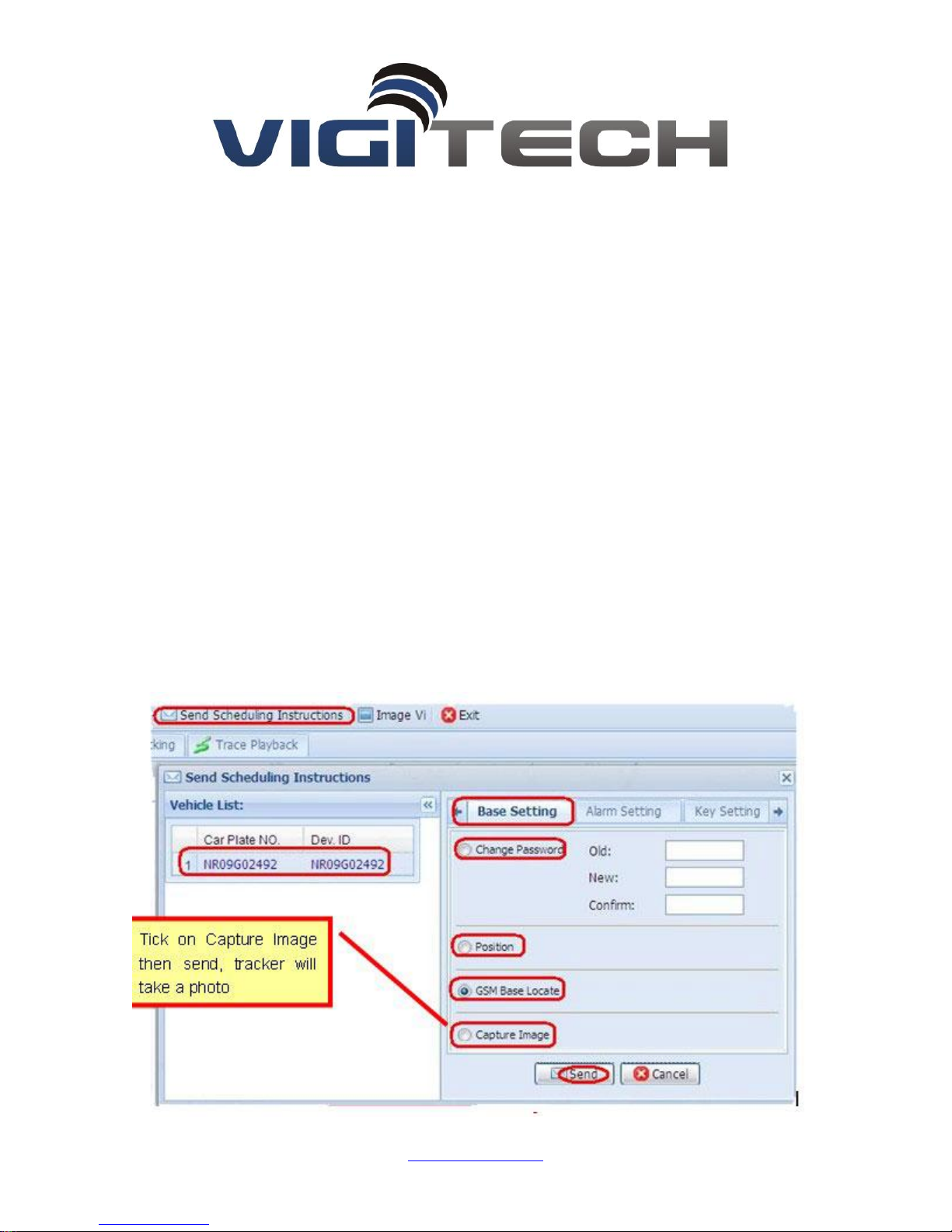
e.g. A000000,019,0
How Does Camera Monitoring Work?
Please follow below steps to use camera function (camera connected)
1.Send following commands to connect TAG 707 or TAG 710 to tracking centre
Set IP:A000000,010,121.37.58.10,6903
Open GPRS: A000000,011,1
Set APN:A000000,012,APN
2.Send A000000,019,1 to open camera (A000000,019,0 is to close)
http://www.gpspos.cn/gismng/
3.Log in tracking centre to let tracker take photos with admin account
1250 S. Alhambra Circle #10
Coral Gables, FL 33146
Page 10
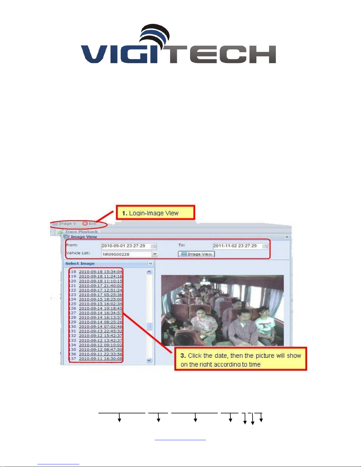
4.View the taken photos
5. If you still can’t check the image on the server, please send SMS: A000000, 004 to
Check the query
N R 0 9 G0 0 0 0 1, CMNET, 1 2 1 .3 7 .5 8 .1 0, 6 9 0 3, 1, 1, 2 4
1250 S. Alhambra Circle #10
Coral Gables, FL 33146
Page 11

1 2 3 4 5 6 7
(1)Device ID
(2)APN (China Mobile is CMNET, China Unicom is UNINET)
(3)Server IP address
(4)Server port
(5)GPRS open status(0- off ,1- on)
(6)GPRS connecting status(0- Internet is bad,1- work well)
(7)GSM signal value(1~31),if value<10 is too weak to work well.
IF the images can’t be checked on the server ,pls check the (7) above , because the GSM
signal is too weak and you need to change a place with good GSM signal for testing .
6. Now the set of taking picture is Snapshot , when the engine on or alarm on or accident ,
it will take pictures automatically, if you want to take picture as time interval ,you can set
by yourself , like taking picture every 30secs
5 GPRS Communication Settings
5.1 Set APN (APN(Access Point NAME))
Message format: A******,012,APN
Length of APN is limited within 100 characters, E.g:A000000,012,cmnet
“cmnet”is the APN of China Mobile
5.2 Set the IP and Port of Gprs_Server
Message format: A******,010,IP,PORT
e.g. A000000,010,121.37.58.10,6903
121.37.58.10 is the IP of GPRS_server, 6903 is the port of GPRS_Server application (be in
communication with GPS camera tracker)
1250 S. Alhambra Circle #10
Coral Gables, FL 33146
Page 12

5.3 Open GPRS function
Message format: A******,011,X
(note:x=1 open GPRS, X=0 close GPRS)
e.g. A000000, 011, 1
GPRS function will be open, and GPS Camera tracker will send data to Internet, Users can turn
off this function though send SMS: A000000, 011, 0
5.4 Query the GPRS Setting
Message format: A******,004
The device will send back GPRS setting parameters. You can check whether the parameter sets
correctly by it.
(1)Device ID
(2)APN (China Mobile is CMNET, China Unicom is UNINET)
(3)Server IP address
(4)Server port
(5)GPRS open status(0- off ,1- on)
(6)GPRS connecting status(0- Internet is bad,1- work well)
(7)GSM signal value(1~31),if value<10 is too weak to work well.
1250 S. Alhambra Circle #10
Coral Gables, FL 33146
Page 13
6 GPS tracking system on website
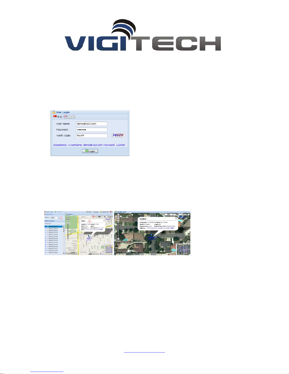
6.1 User Login
Google Map can support many different languages. It can change language for local language
by itself.
6.2 Vehicle real-time tracking
1 choose vehicle 2 map mode 3.vehicle state, Google map have 3 model: map mode
,satellitic mode and Hybrid mode
Map mode satellites mode:
6.3 Vehicle history record playback
Please point run history review page
1 choose vehicle 2 start time 3 inquire time 4.setup review speed 5 start review
process you can know that time date , speed , way and distance sum.
1250 S. Alhambra Circle #10
Coral Gables, FL 33146
Page 14
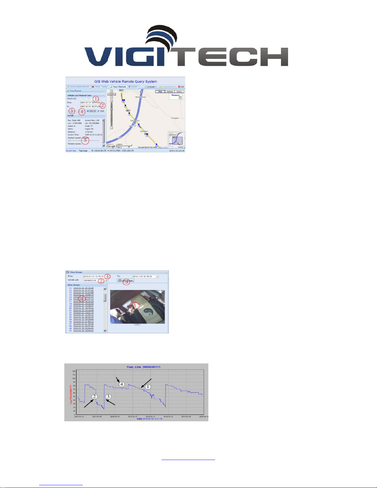
6.4 View image
1 Select date range2Select Vehicle3View Image 4Click the time link to display image
5Image
6.5 Fuel Line
Shows as above:
1250 S. Alhambra Circle #10
Coral Gables, FL 33146
Page 15
1 It shows normal fuel consumption. The fuel decreases slowly.
2 It shows abnormal fuel consumption, and it decreases straightly. It may be fuel leak or fuel
stolen.
3 It shows the fuel increases straightly. It should be in fuel up.
4 It shows the fuel without change. It should be in parking.
7. Navigation scheduling management operations
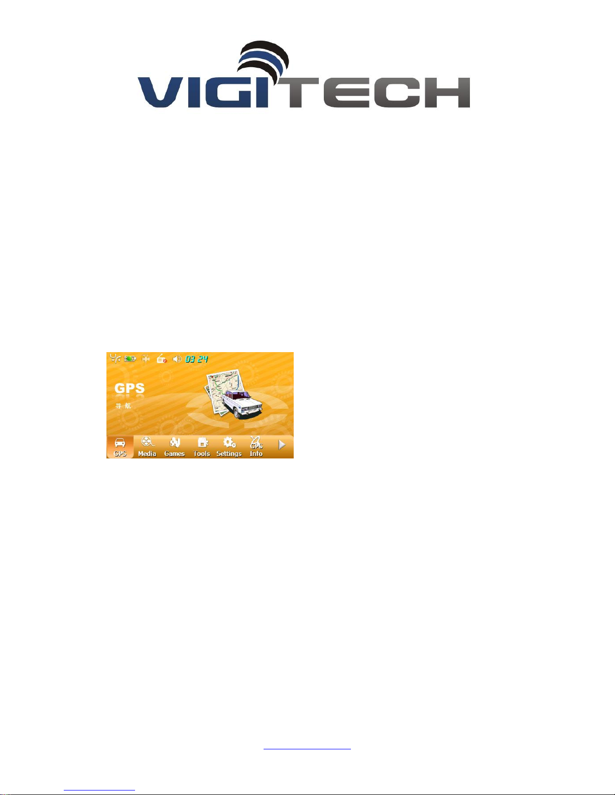
7.1 Start Navigation to setting:
When Navigation starts, the interface will shows above, the user can click Settings, set the
GIS scheduling software, select the Nav Path , then select Autorun.exe programme from SD card.
Selecting Auto run navigation. Then click save it , retreated to the main interface, click on the
GPS, the interface will enter into the GIS scheduling management interface (7.2), when open
navigation each time at later, GIS will be automatically entered GIS scheduling management
interface
1250 S. Alhambra Circle #10
Coral Gables, FL 33146
Page 16
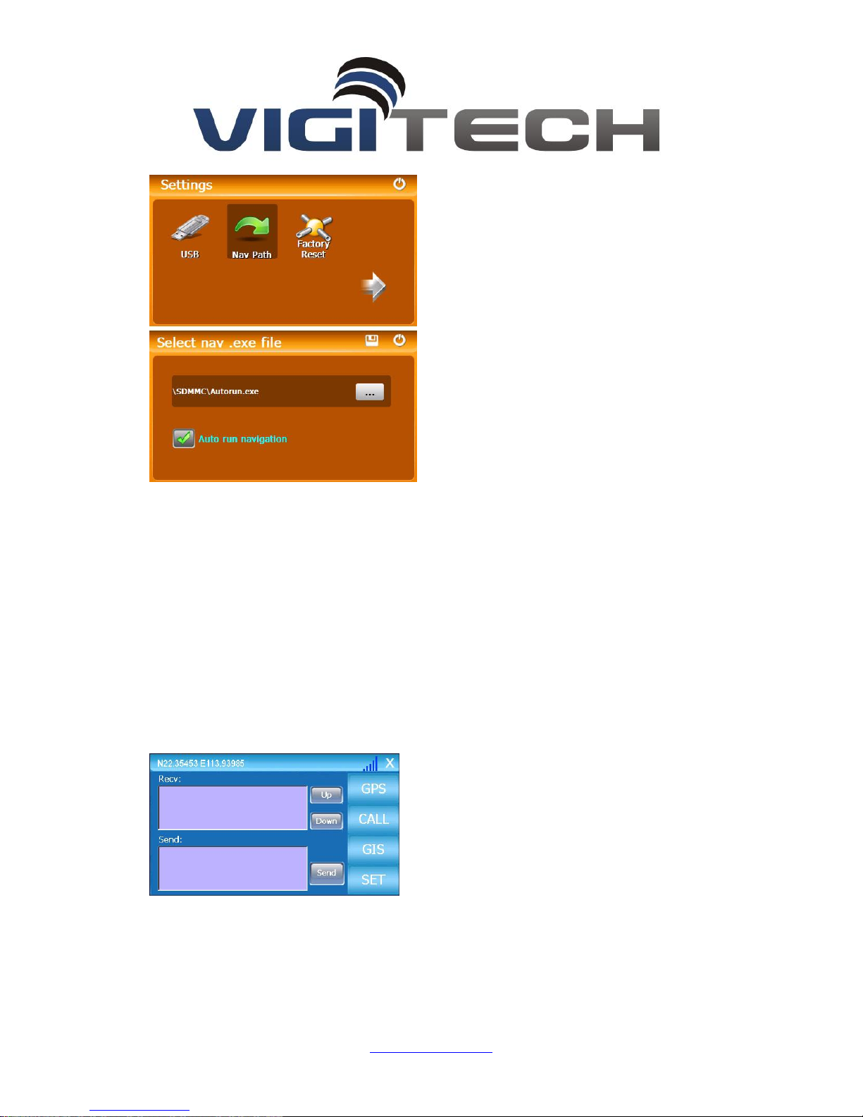
8. GIS messaging operations
Use mini_usb, connected the tracker with navigation, after communication is normal, the last
column shows the latitude and longitude information and the strength of GSM, Recv box will show
the scheduling information and the broadcast information, from the GIS management platform
and the broadcast information, the driver can Enter the information in the send form, and sent it
to GIS management center.
Click the “SET” button, the user interface is as following, and the user can set the APN, the
server IP and the navigation map paths, the user can open the GPRS or close the GPRS via this
interface after setting the APN,IP & navigation map.
1250 S. Alhambra Circle #10
Coral Gables, FL 33146
Page 17
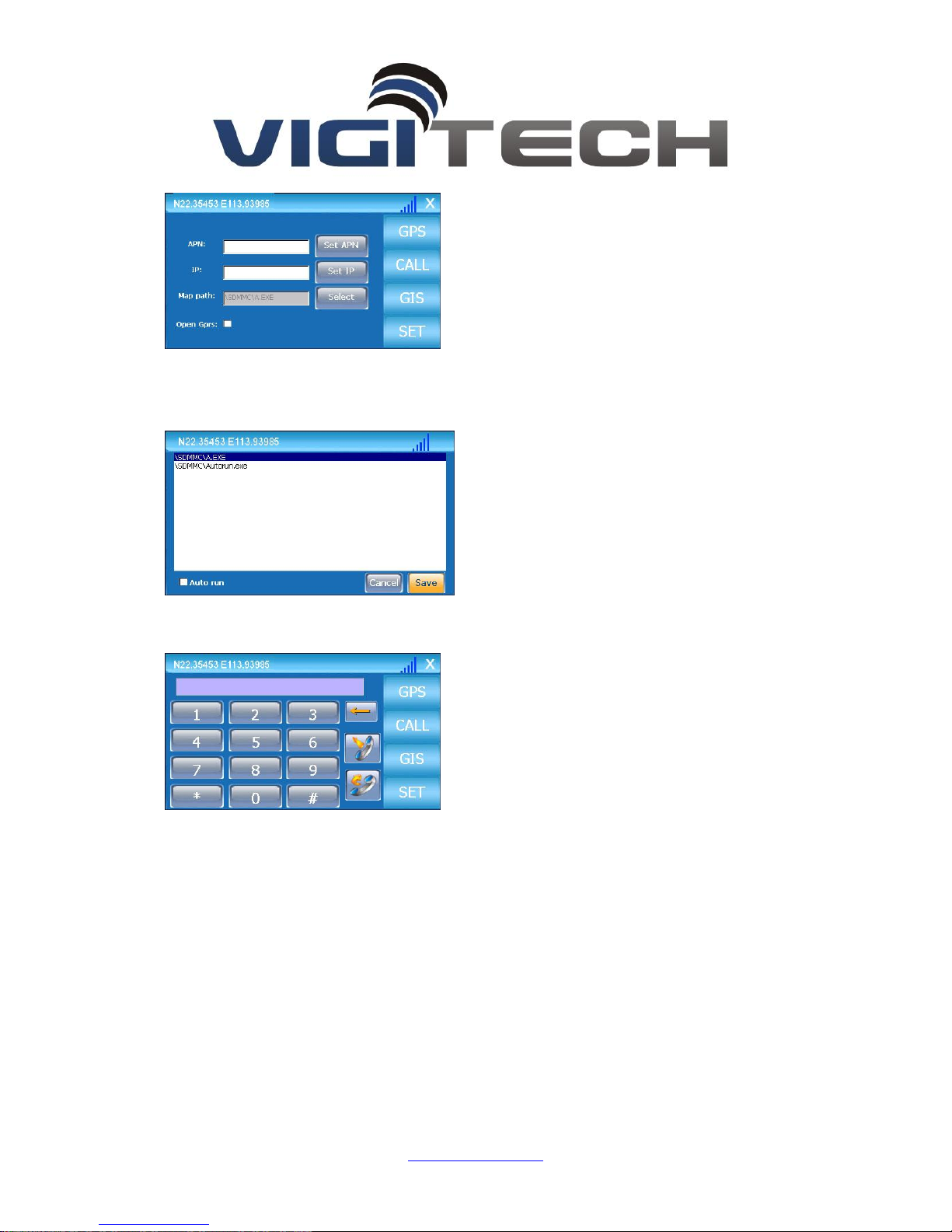
Click the “Select” button, select navigation maps, the local navigation maps installed in the SD
card, which is bought by the user, the parameter of navigation is COM1, Baud Rate 9600bps
Telephone calling operations:
The driver can make telephone call via the navigator, click the “CALL” button the user
interface is as following,
1250 S. Alhambra Circle #10
Coral Gables, FL 33146
 Loading...