

Uniden TRAX4300 Owner's Manual

TRAX4300
In-Car Navigation
OWNER’S MANUAL

Thank you for purchasing this Uniden product. Read the Quick Start Guide first and start using your
device right away. This document is the detailed description of the navigation software. You can easily
discover your device while you are using it; however, we still recommend that you read this manual to
fully understand the screens and the features of your software.
Page 2

Table of Contents
What Do I Do First? 5
Make Sure These Items Arrived in the Box 5
Plug it in 5
Hardware Keys 6
How Do I Put It in My Car? 7
Safety considerations 7
Attaching the windshield mount 7
Adjusting the windshield mount 8
Mounting on the windshield 8
1 Warnings and Safety information 9
2 Getting started 10
2.1 Startup screen: the Navigation menu 12
2.2 Hardware buttons 12
2.3 Buttons and other controls on the screen 13
2.3.1 Using keyboards 14
2.3.2 Beyond single screen tap 14
2.4 Map screen 15
2.4.1 Navigating on the map 15
2.4.2 Position markers 17
2.4.2.1 Vehimarker and Lock-on-Road 17
2.4.2.2 Selected location (Cursor) in Find on Map 17
2.4.3 Objects on the map 17
2.4.3.1 Streets and roads 17
2.4.3.2 Turn Preview and next street 18
2.4.3.3 Lane information and Signposts 19
2.4.3.4 3D object types 19
2.4.3.5 Elements of the active route 20
2.4.4 Manipulating the map 20
2.4.5 Quick menu 22
2.4.6 Checking the details of the current position (Where Am I?) 23
3 Navigating 25
3.1 Selecting the destination of a route 25
3.1.1 Entering an address or part of an address 25
3.1.1.1 Entering an address 25
3.1.1.2 Entering the midpoint of a street as the destination 28
3.1.1.3 Selecting an intersection as the destination 30
3.1.1.4 Selecting a city/town centre as the destination 32
3.1.1.5 Entering an address with a postal code 34
3.1.1.6 Tips on entering addresses quickly
3.1.2 Selecting the destination from the Places of Interest 36
3.1.2.1 Selecting the destination from the Places of Interest with Quick search 37
36
Page 3

3.1.2.2 Selecting the destination from other Places of Interest by name 39
3.1.2.3 Selecting the destination from other Places of Interest by category 41
3.1.2.4 Selecting nearby assistance from ‘Where Am I?’ 44
3.1.3 Selecting a map location as the destination 46
3.1.4 Selecting the destination from your Favourites 46
3.1.5 Selecting the most likely destination (Smart History) 47
3.1.6 Selecting the destination from the History 48
3.2 Viewing the entire route on the map 49
3.3 Checking the route parameters 49
3.4 Modifying the route 50
3.4.1 Replacing the destination of the route 50
3.4.2 Setting a new starting position for the route 51
3.4.3 Pausing the active route 52
3.4.4 Deleting the active route 52
3.4.5 Changing the route planning method 52
3.4.6 Checking the route alternatives 53
3.4.7 Changing the vehicle used in route planning 55
3.4.8 Changing the road types used in route planning 56
3.5 Adding the destination of the route to Favourites 57
3.6 Watching the simulation of the route 58
4 Reference Guide 60
4.1 Concepts 60
4.1.1 Smart Zoom 60
4.1.2 Daytime and night colour themes 60
4.1.3 Colour theme in tunnels 60
4.1.4 Route calculation and recalculation 60
4.1.5 Road Safety Cameras 61
4.1.5.1 Camera types 60
4.1.5.2 Camera directions 60
4.1.6 Speed limit warning 63
4.1.7 Battery and GPS position quality indicators 63
4.2 ‘More’ menu 64
4.3 Settings menu 65
4.3.1 Route settings 66
4.3.2 Sound settings 67
4.3.3 3D vehicle gallery 68
4.3.4 Colour themes 69
4.3.5 Set starting position 69
4.3.6 Regional settings 69
4.3.7 Content 70
5 Glossary 71
6 End User Licence Agreement 73
7 Limited One Year Warranty 77
Page 4
What Do I Do First?
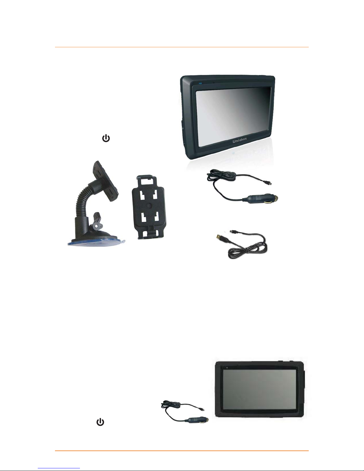
Make Sure These Items Arrived in the Box
If anything listed here is missing or damaged,
contact your place of purchase immediately.
TRAX4300 GPS navigation device ►
Slide the power switch at the BOTTOM
of the device to the on position, and then
press the suspend
the device to turn the navigation on or off.
button at the TOP of
Part 1 Part 2
Windshield Mount (2 part) ►
OM CD-ROM ►
Quick Start Guide sheet ►
Plug it in
Connect the power adapter to the power connector on the lower left side of the device. ►
Plug the other end into your car’s cigarette lighter (or any standard 12VDC - 24VDC outlet). ►
Only use the power adapter that came with your device. Any other adapter might damage the ►
device.
Whenever it senses power coming in and the power
►
switch is on, the device charges the battery.
As soon as the power stops (for example, when you
►
unplug the adapter or turn off your car), the device
automatically shuts down. If you want it to stay on,
tap cancel on the screen during the Shutting down
message.
You can put the device into sleep
►
mode anytime you want: just push
the suspend
device.
button on top of the
DC (car) adapter ►
USB cable ►
Page 5
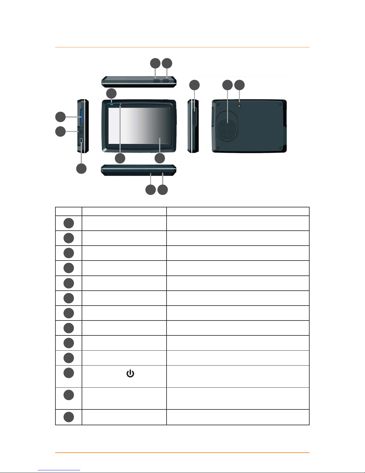
Hardware Keys
2
7
8
11
10
56
4
3
1
9
1213
Ref Component Description
Touch Screen Display the output on your device
1
LED Blue--Charging; Off--full charged
2
N/A N/A
3
External GPS antenna
4
connector
Speaker Send out music, sounds, and voice
5
Volume up/down button Increase or decrease the volume level
6
SD card slot SD card slot
7
Headphone connector Connect to stereo headphones
8
Use an optional external GPS antenna
Mini USB connector Connect to the charger or USB cable
9
10
11
12
13
Page 6
Menu button Return to main menu
Suspend button
Reset hole If the device fails to operate properly, try resetting the
Power switch For intial start up, push the power switch to the on
When the power switch is on (see ref 13 below) press
the suspend button to enter into or exit out of sleep
mode.
device. Press the reset button by using the ball point
pen or a similar tool.
position to power the device.
How Do I Put It in My Car?
Safety Considerations
Don’t install any device where it will block your view (including your mirrors!) while you’re driving. ►
Keep your attention on the road! ► Don’t try to operate or focus on any device while you’re driving.
If you have to concentrate on a device, pull off the road for a few minutes.
It’s a good idea to take valuable items with you when you leave you car—that includes GPS
►
devices. If you can’t take the device with you, lock it in the glove compartment or hide it
somewhere. And don’t forget to take down the windshield mount: you don’t want to remind any
potential thieves that you might have some valuable mobile electronics in the car.
Don’t leave the device in direct sunlight for a long period of time or where the temperature could
go above 60º C (140º F).
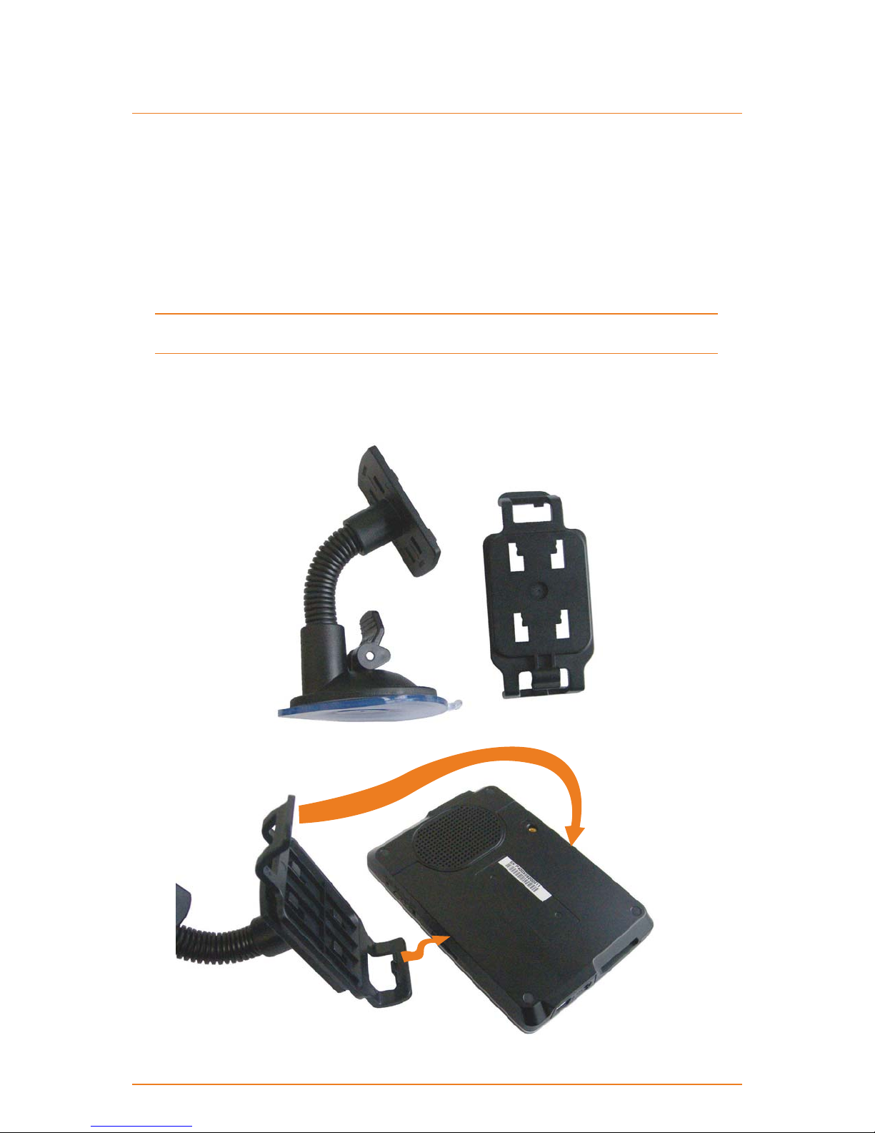
Attaching the windshield mount
Assemble the Windshield mount by slotting Part 2 onto Part 1. ►
Part 1 Part 2
Insert the bracket hook into the ►
notch at the bottom of the device.
Rotate the bracked up so
►
the head fits into the gap.
Page 7
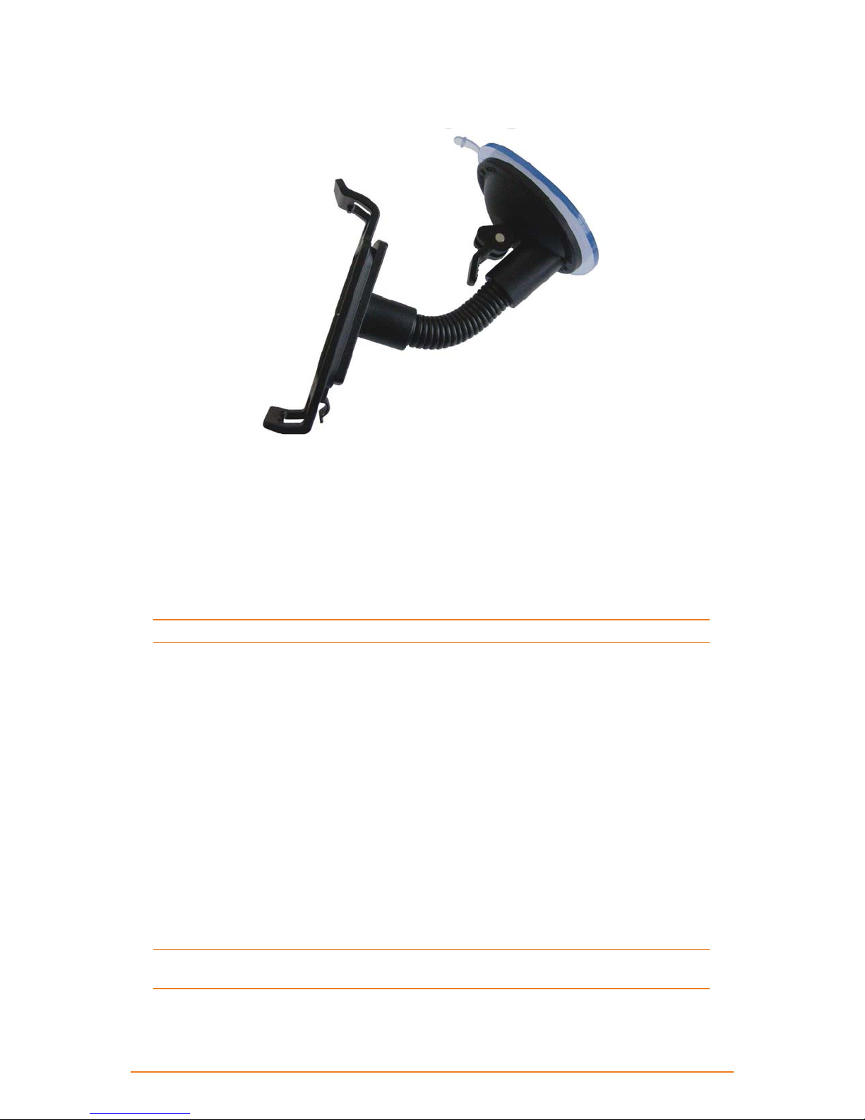
Adjusting the Windshield Mount
Bend the windshield mount arm to a suitable angle for mounting. ►
Mounting on the Windshield
Make sure the device does not block your view of the road or your mirrors.
Once you decide where you want the device, hold the suction cup in that position, then adjust the
mount so you have the best view of the device.
Press the suction cup flat against the windshield.1)
Push the suction lock up (towards the suction cup) until it snaps into place.2)
Gently pull on the mount to make sure it is secure.3)
If you have trouble getting the suction cup to stick:
Clean the spot with an ammonia-free cleanser.
►
Dry the spot completely (use a lint-free cloth, if possible). ►
Make sure the spot is smooth and flat (suction cups won’t stick well on a curved or textured ►
surface).
Removing the windshield mount
When you release the suction latch, make sure you’re holding or somehow supporting the
device.
Lift the suction latch and use the plastic pull tab to pull the suction cup off of the glass.
Page 8

1 Warnings and Safety information
This software is a navigation system that helps you find your way to your destination with the built-in
GPS receiver. The software does not transmit your GPS position; others cannot track you.
It is important that you look at the display only when it is safe to do so. If you are the driver of the
vehicle, we recommend that you operate your software before you start your journey. Plan the route
before your departure and stop if you need to change the route.
You must obey the traffic signs and follow the road geometry. If you deviate from the recommended
route, your software changes the instructions accordingly.
Never place your device where it obstructs the driver’s view, where it is in the deployment zone of an
airbag or where it might cause injuries in an accident.
For more information, consult the End User Licence Agreement (page 73).
Page 9
2 Getting started
The software is optimised for in-car or pedestrian use. There is no need to use a stylus. You can use it
easily by tapping the screen buttons and the map with your fingertips.
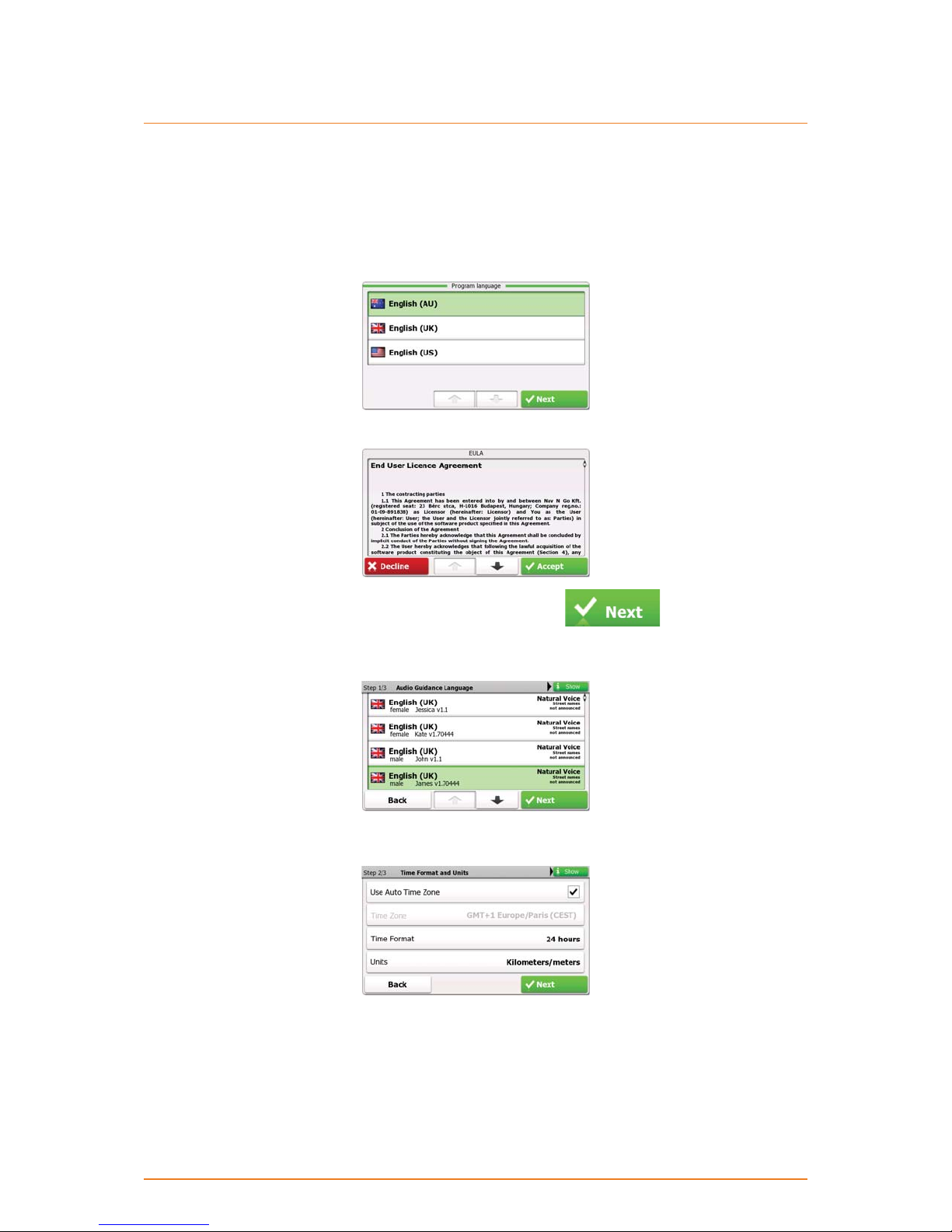
When using the navigation software for the first time, an initial setup process starts automatically. Do
as follows:
1. Select the written language of the application interface. Later you can change it in Regional settings
(page 69).
2. Read and accept the End User Licence Agreement.
3. The Configuration wizard starts in the selected language. Tap to continue.
4. Select the language and speaker used for voice guidance messages. Later you can change it in
Regional settings (page 69).
5. If needed, modify the time format, time zone and unit settings. Later you can change them in
Regional settings (page 69).
6. If needed, modify the default route planning options. Later you can change them in Route settings
(page 66).
Page 10
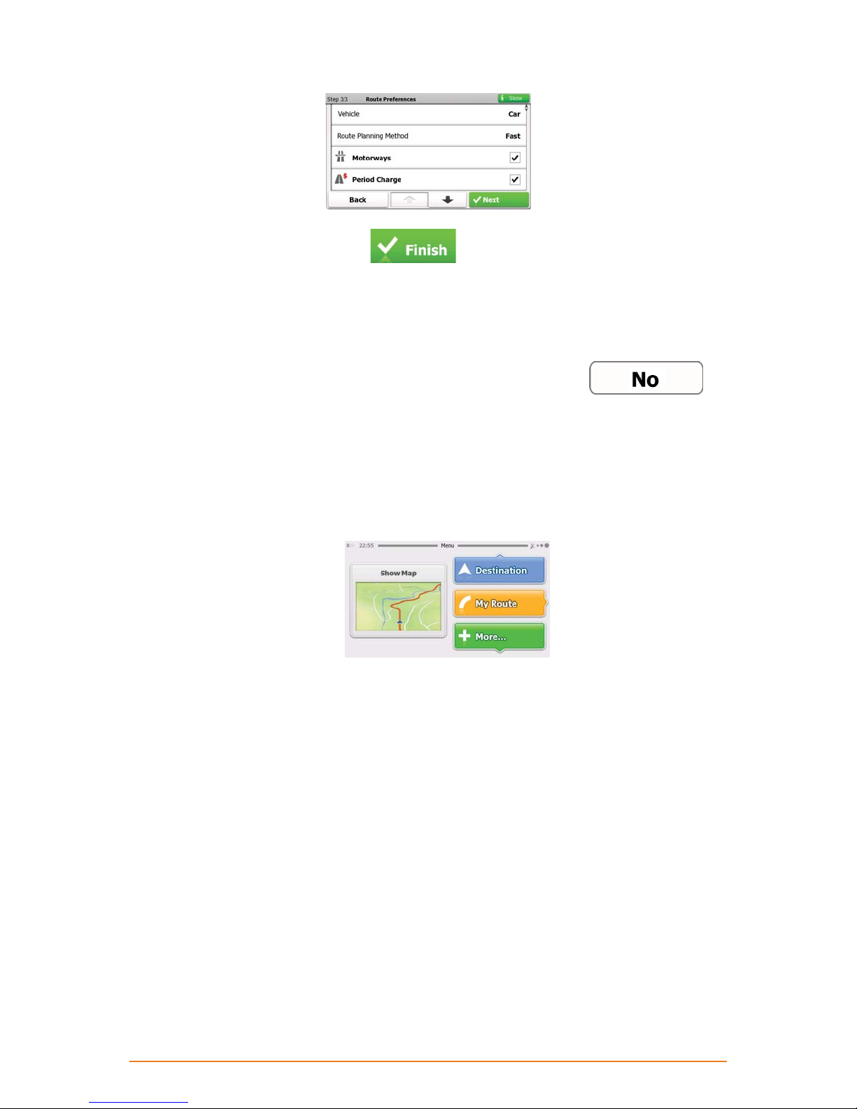
7. The initial setup is now complete. Tap to proceed. The Configuration wizard can be
restarted later from the Settings menu (page 65).
8. You are offered to watch the Tutorial that leads you through the basic steps of navigation, or to run
Demo route simulations. To start using the software right away, you can tap
skip the tutorial as you can run it later from the ‘More’ menu (page 64).
After the initial setup, the Navigation menu appears and you can start using the software. This is the
9.
screen you see every time navigation starts.
The typical way of using the software is to select a destination, and start navigating. You can select
your destination in the following ways:
• Enter a full address or a part of an address, for example a street name without a house number or
the names of two intersecting streets (page 25).
• Enter an address with postal code (page 34). This way you do not need to select the name of the
settlement and the search for street names might be faster as well.
to
Page 11
• Use a built-in Place of Interest as your destination (page 36).
• Select a location on the map with the Find on Map feature (page 46).
• Use a previously saved Favourite destination (page 46).
• Select a location from the History of previously used destinations (page 48).
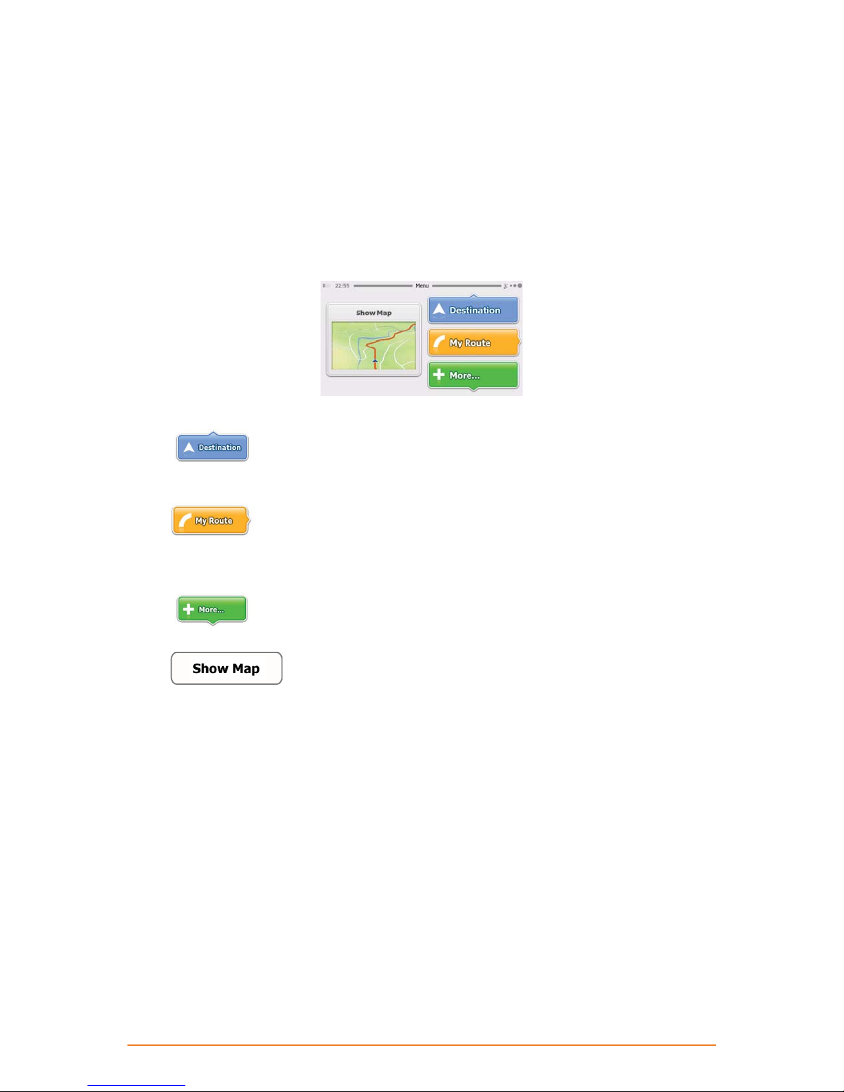
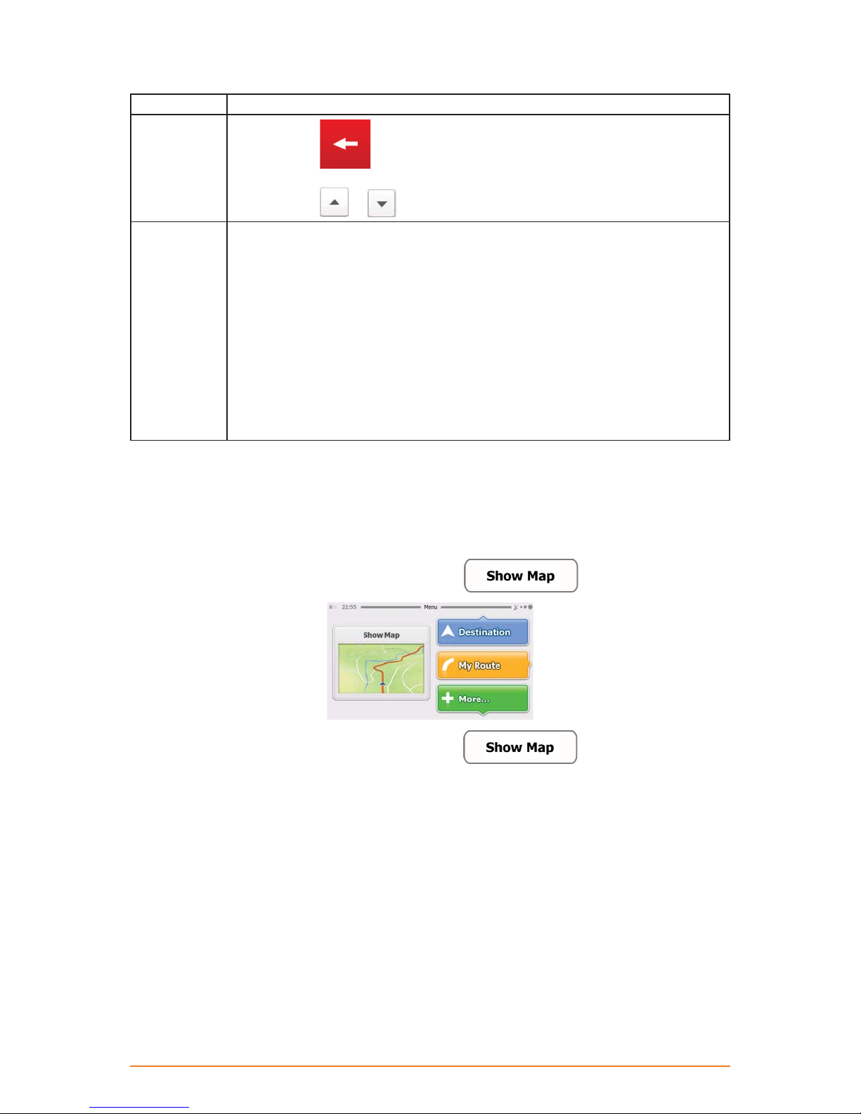
2.1 Startup screen: the Navigation menu
The software starts with its main menu, the Navigation menu. From here you can reach all parts of the
software.
You have the following options:
• Tap
interest, a location on the map or one of your Favourite destinations. You can also look up your
recent destinations from the Smart History.
• Tap
You can also perform route-related actions such as cancelling your route, picking route alternatives,
simulating navigation or adding the destination to your Favourites. (This button remains inactive if
there is no destination given.)
• Tap
Tutorial, run some additional applications, or to get extra content from www.naviextras.com.
• Tap
shows your current position, the recommended route and the surrounding map area. Tap the button
to enlarge the map to the full screen.
to select your destination by entering an address or selecting a place of
to display the route parameters and the route in its full length on the map.
to customise the way the navigation software works, watch the Demo &
to start navigating on the map. The button itself is a miniature live map that
2.2 Hardware buttons
You can use your software mostly by tapping the touch screen. The device has only a few hardware
buttons.
You can turn the your device on or off at any time. When the your device is switched off, your software
does not calculate your GPS position and it does not update the route or the driving instructions.
When you turn the device on again, your software continues navigating as soon as the GPS receiver
has determined your position.
Page 12
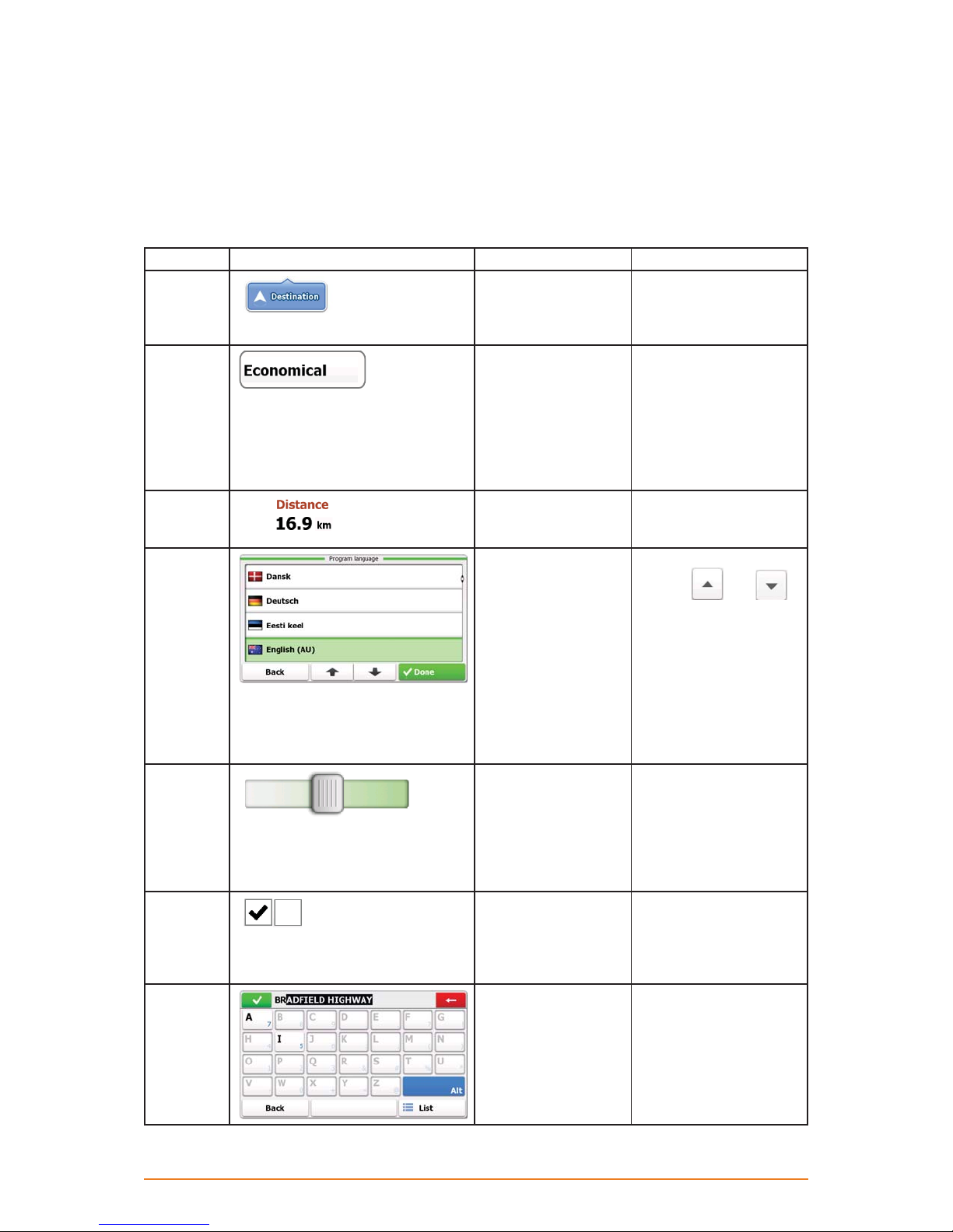
2.3 Buttons and other controls on the screen
When you are using the software, you usually tap buttons on the touch screen.
You only need to confirm selections or changes if the application needs to restart, it needs to perform
a major reconfiguration, or you are about to lose some of your data or settings. Otherwise, the
software saves your selections and applies the new settings without confirmation as soon as you use
the controls.
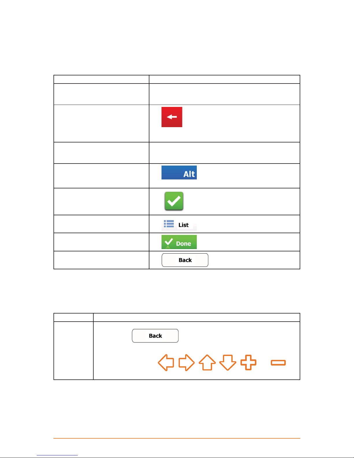
Type Example Description How to use it
Button
Button with
value
Icon
List
Slider
Switch
Virtual
keyboard
Tap it to initiate a
function, to open a
new screen, or to set
a parameter.
Some buttons display
the current value of
a field or setting. Tap
the button to change
the value. After the
change, the new
value is shown on the
button.
Shows status
information.
When you need to
select from several
options, they appear
in a list.
When a feature can
be set to different
values in a range, the
software shows an
indicator on a gauge
that displays and sets
the value.
When there are
only two choices, a
checkmark shows
whether the feature is
enabled.
Alphabetic and
alphanumeric
keyboards to enter
text and numbers.
Tap it once.
Tap it once.
Some icons also function
as a button. Tap them
once.
Move between pages
with the
buttons and tap the value
that you want.
Alternatively, grab the
list anywhere and slide
your finger up or down.
Depending on the speed
of the sliding, the list will
scroll fast or slow, only a
bit or till the end.
• Drag the handle to
move the slider to its
new position.
• Tap the slider where
you want the handle to
appear; the thumb jumps
there.
Tap it to turn the switch
on or off.
Each key is a touch
screen button.
and
Page 13
2.3.1 Using keyboards
You only need to enter letters or numbers when you cannot avoid it. You can type with your fingertips
on the full-screen keyboards and you can switch between various keyboard layouts, for example
English, Greek or numerical.
Task Details
Switching to another keyboard
layout, for example from an English
keyboard to a Greek keyboard
Correcting your entry on the
keyboard
Entering a space, for example
between a first name and a family
name or in multi-word street names
Entering numbers and symbols
Finalising the keyboard entry
(accepting the suggested search
result)
Finalising the keyboard entry
(opening the list of search results)
Finalising the keyboard entry (saving
your input)
Cancelling the keyboard entry
(returning to the previous screen)
This cannot be done when you are already using the virtual
keyboard. You can do it in Regional settings (page 69).
Tap
Tap and hold the button to delete several characters or the
entire input string.
Tap the empty button at the bottom centre of the screen.
Tap
and symbol characters.
Tap
Tap
Tap
Tap
to remove the unneeded character(s).
to switch to a keyboard offering numeric
.
.
.
.
2.3.2 Beyond single screen tap
You usually need to tap the screen only once. However, some useful features can be accessed with
combined touch screen tapping. Those are the following:
Tasks Instructions
Tapping and
holding the
screen
Page 14
Tap and keep pressing the following buttons to reach extra functions:
• Tap and hold
appears.
• Tap and hold any of the
buttons on the Map screen: you can rotate, tilt or scale the map continuously.
on list and menu screens: the Map screen
, , , , and
Tasks Instructions
• Tap and hold on keyboard screens: you can delete several characters
quickly.
or in long lists: you can scroll pages continuously.
Gestures
(drag&drop)
• Tap and hold
You need to drag and drop the screen only in cases like:
• Moving the handle on a slider.
• Scrolling the list: grab the list anywhere and slide your finger up or down.
Depending on the speed of the sliding, the list will scroll fast or slow, only a bit or till
the end.
• Moving the map in map browsing mode: grab the map, and move it in the desired
direction.
• Shortcut to open the Map screen: slide your finger from the bottom right corner to
the bottom left corner on any screen.
• Shortcut to open the Navigation menu: slide your finger from the top left corner to
the bottom left corner on any screen.
2.4 Map screen
2.4.1 Navigating on the map
The Map screen is the most frequently used screen of the software. A small live map is displayed on
the startup screen, the Navigation menu, as a part of the
button.
To enlarge this small map and open the Map screen, tap .
The map is displayed in black and white when there is no GPS position:
Page 15
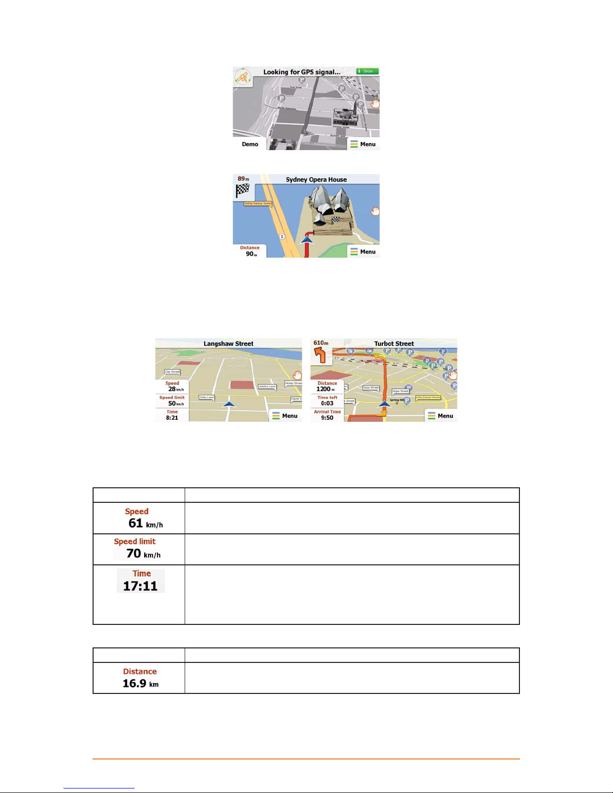
... or in full colour when the current position is available:
This map shows the current position (the Vehimarker, a blue arrow by default), the recommended
route (an orange line), and the surrounding map area.
There are screen buttons and data fields on the screen to help you navigate. During navigation, the
screen shows route information.
Tap the bottom left corner to see all three route data fields.
-
Tap any of the data fields to suppress others and display only the selected one. The data fields are
different when you are navigating an active route and when you have no specified destination (the
orange line is not displayed).
Data fields when cruising without a destination:
Field Description
Shows your current speed given by the GPS receiver.
Shows the speed limit of the current road if the map contains it.
Shows the current time corrected with time zone offset. The accurate time
comes from the GPS satellites, and the time zone information comes from the
map or it can be set manually in Regional settings.
(The current time is always displayed in the top left corner of the high level
menu screens.)
Data fields when navigating a route:
Field Description
Shows the distance you need to travel on the route before reaching your final
destination.
Page 16
Field Description
Shows the time needed to reach the final destination of the route based on
information available for the remaining segments of the route.
The calculation cannot take into account traffic jams and other possible
delays.
Shows the estimated arrival time at the final destination of the route based on
information available for the remaining segments of the route.
The calculation cannot take into account traffic jams and other possible
delays.
2.4.2 Position markers
2.4.2.1 Vehimarker and Lock-on-Road
When your GPS position is available, the software marks your current position with the Vehimarker. By
default, this marker is a blue arrow, but you can change this icon in Settings.
The exact location of the Vehimarker depends on the vehicle type used for route calculation. The
vehicle type can be selected in Route settings (page 66).
• If you choose pedestrian: The Vehimarker is at your exact GPS position. The direction of the icon
shows your current heading.
• If you choose any of the vehicles: The Vehimarker may not show your exact GPS position and
heading. If roads are near, it is aligned to the nearest road to suppress GPS position errors, and
the direction of the icon is aligned to the direction of the road.
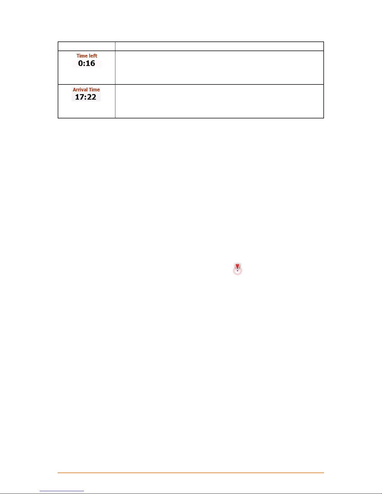
2.4.2.2 Selected location (Cursor) in Find on Map
If you select a location on the map in Find on Map (page 46), the Cursor appears at the selected
point on the map. The Cursor is displayed with a radiating red dot (
levels.
The location of the Cursor can be used as the destination of the route.
) to make it visible at all zoom
2.4.3 Objects on the map
2.4.3.1 Streets and roads
The software shows the streets in a way that is similar to how the paper road maps show them. Their
width and colours correspond to their importance: you can easily tell a motorway from a small street.
Page 17
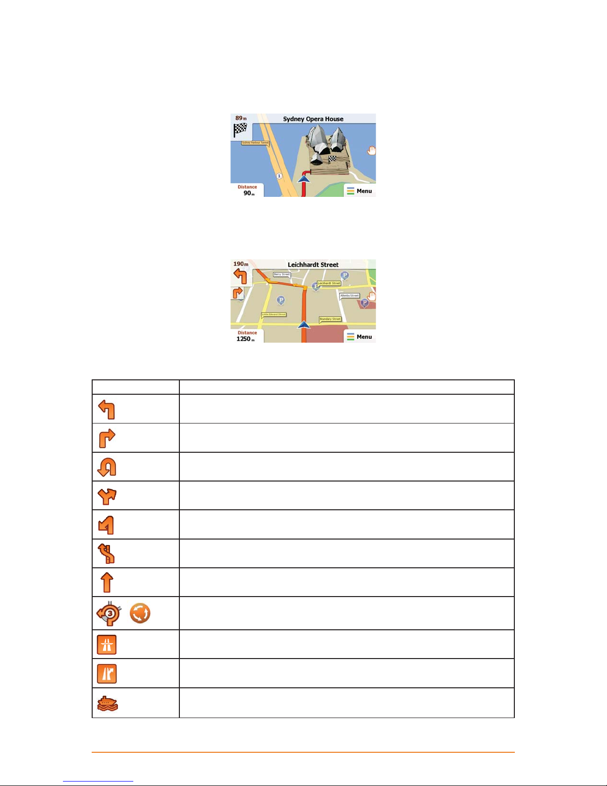
2.4.3.2 Turn Preview and next street
When navigating a route, the top section of the Map screen shows information about the next route
event (manoeuvre) and the next street or the next city/town.
There is a field in the top left corner that displays the next manoeuvre. Both the type of the event (turn,
roundabout, exiting motorway, etc.) and its distance from the current position is displayed.
A smaller icon shows the type of the second next manoeuvre if it is near the first one. Otherwise, only
the next manoeuvre is displayed.
Most of these icons are very intuitive. The following table lists some of the frequently shown route
events. The same symbols are used in both fields:
Icon Description
Turn left.
Turn right.
Turn back.
Bear right.
Turn sharp left.
Keep left.
Continue straight in the intersection.
Enter roundabout. The layout of the roundabout and the number of the exit is
,
shown only for the next turn.
Enter motorway.
Exit motorway.
Board ferry.
Page 18
Icon Description
Leave ferry.
Approaching the destination.
2.4.3.3 Lane information and Signposts
When navigating on multilane roads, it is important to take the appropriate lane in order to follow the
recommended route. If lane information is available in the map data, the software displays the lanes
and their directions using small arrows at the bottom of the map. Highlighted arrows represent the
lanes you need to take.
Where there is additional information available, signposts substitute arrows. Signposts are displayed
at the top of the map. The colour and style of the signposts are similar to the real ones you can see
above road or by the roadside. They show the available destinations and the number of the road the
lane leads to.
All signposts look similar when cruising (when there is no recommended route). When navigating a
route, only that signpost is displayed in vivid colours that points to the lane(s) to be taken; all others
are darker.
-
2.4.3.4 3D object types
Your software supports the following 3D object types:
Type Description
3D terrain 3D terrain map data shows changes in terrain, elevations or depressions in the
land when you view the map in 2D, and use it to plot the route map in 3D when you
navigate. Hills and mountains are shown in the background of the 3D map, and
illustrated by colour and shading on the 2D map.
Elevated
roads
3D
landmarks
Complex intersections and vertically isolated roads (such as overpasses or bridges)
are displayed in 3D.
Landmarks are 3D artistic or block representations of prominent or well-known objects.
3D landmarks may not be part of the original software or they may need additional
activation. They are only available in selected cities and countries.
Check www.naviextras.com for details.
Page 19
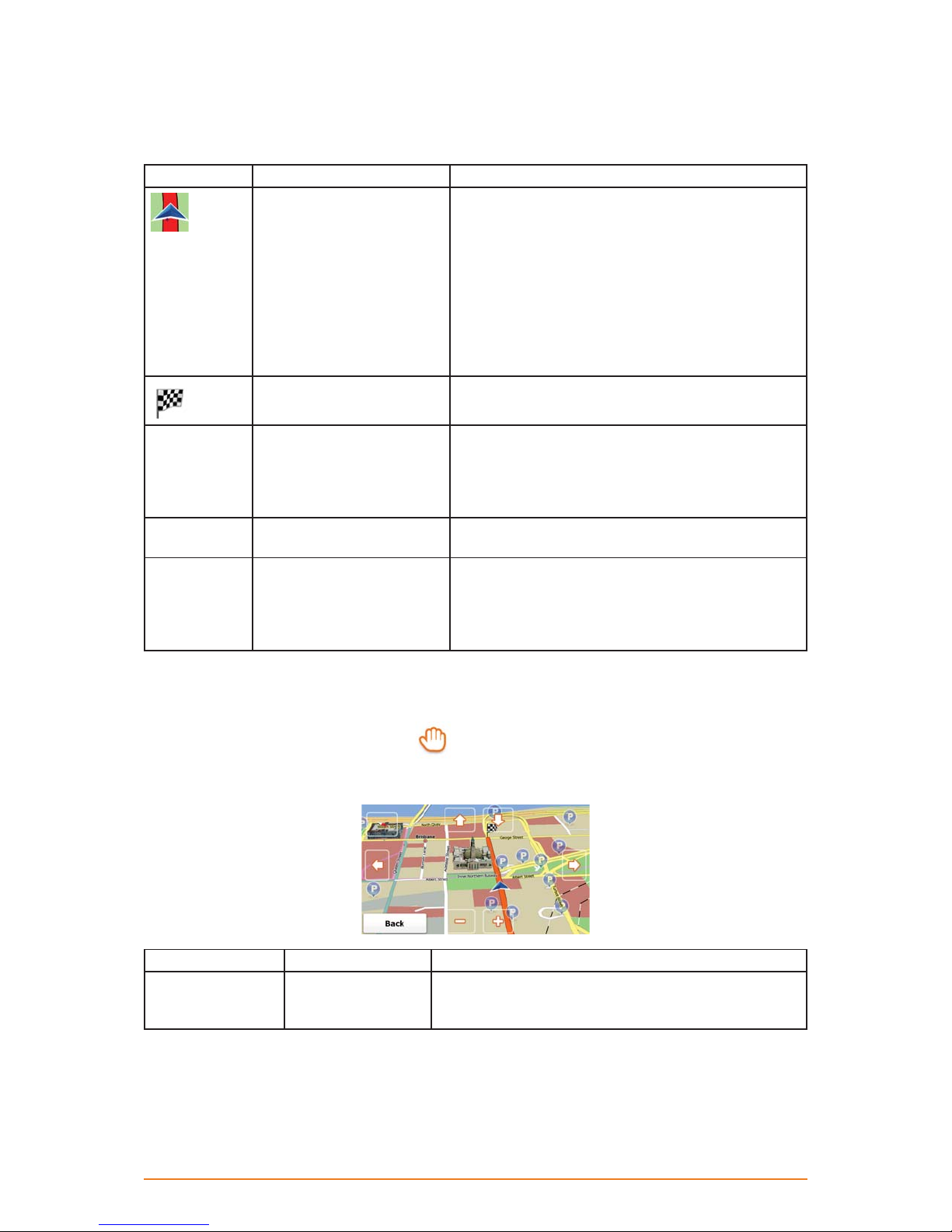
2.4.3.5 Elements of the active route
Your software shows the route in the following way:
Symbol Name Description
Current GPS position and
Start point
Destination (end point) The last point of the route.
Map colour The map is vivid and colourful when GPS position
Route colour The route always stands out with its colour on the
Streets and roads that
are excluded from the
navigation
Your current position displayed on the map.
• In pedestrian mode it is the exact GPS position.
• If a vehicle is selected for route calculation and
roads are near, the symbol is snapped onto the
nearest road.
Normally if GPS position is available, the route starts
from the current position. If there is no valid GPS
position, your software uses the last known position
as the start point.
is available. Whenever the current position is not
available, the map turns grey. The software however
may still move the Vehimarker to show a possible but
not confirmed position.
map, both in daytime and in night colour mode.
You can choose whether you want to use or avoid
certain road types (page 66). However, when your
software cannot avoid such roads, the route will
include them and it will show them in a colour that is
different from the route colour.
2.4.4 Manipulating the map
To browse the map during navigation, tap . The map stops following the current position (the
Vehimarker, a blue arrow by default, is not locked in a fix position on the screen any more) and control
buttons appear to help you modify the map view.
Action Button(s) Description
Moving the map
with drag&drop
No buttons You can move the map in any direction: tap and hold
the map, and move your finger towards the direction
you want to move the map.
Page 20
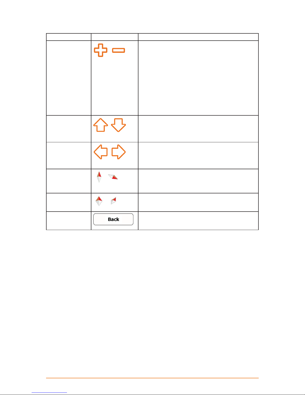
Action Button(s) Description
Zooming in and out
Changes how much of the map is displayed on the
screen.
,
your software uses high-quality vector maps that let you
examine the map at various zoom levels, always with
optimised content. It always displays street names and
other text with the same font size, never upside-down,
and you only see the streets and objects that you need.
Map scaling has a limit in 3D map view mode. If you
zoom out further, the map switches to 2D view mode.
Tap the button once to modify the view in large steps,
or tap and hold the button to modify it continuously and
smoothly.
Tilting up and down
,
Changes the vertical view angle of the map in 3D mode.
Tap the button once to modify the view in large steps,
or tap and hold the button to modify it continuously and
smoothly.
Rotating left and
right
,
Changes the horizontal view angle of the map.
Tap the button once to modify the view in large steps,
or tap and hold the button to modify it continuously and
smoothly.
Compass in 2D
map view mode
,
The direction of the compass shows North. Tap the
button to switch to North-up view, then tap again to
rotate the map in the previous direction.
Compass in 3D
map view mode
Return to normal
navigation
The direction of the compass shows North. Tap the
,
button to switch to North-up view, then tap again to
rotate the map in the previous direction.
Tap this button to move the map back to the current
GPS position. If the map has been rotated, automatic
map rotation is also re-enabled.
Page 21
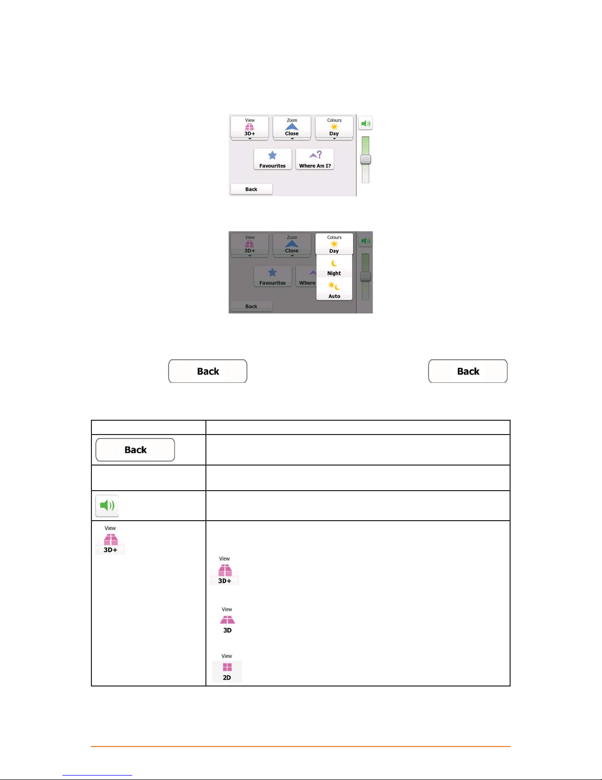
2.4.5 Quick menu
The Quick menu is a selection of controls that are frequently needed during navigation. It can be
opened directly from the Map screen by tapping the map.
Buttons in the top row: These buttons are switches. Their current value is displayed on the button. Tap
any of the buttons to see all values.
Now tap any of the values and your selection takes immediate effect. The Map screen returns
automatically.
Buttons in the middle row: These buttons open new screens. Work on those screens, and when you
get back here, tap
on any screen to return to the Map screen directly.
The buttons and their values on this screen are the following:
Button Function
If you do not use the switches in the top row, you need to use this button
to return to the Map screen.
Master Volume slider Adjusts the sound volume of the device. All sounds of the application are
affected.
Use the switch to mute all sounds of the device and then to re-enable
them again.
The map can be displayed in a perspective view (3D) or in a top-down
view (2D), and in 3D mode buildings can be displayed on the map.
Selectable values:
data is installed in the software, buildings are visible on the map.
suppressed.
to return to the Map screen or tap and hold
: The map is displayed in 3D (perspective) view. If 3D building
: The map is displayed in 3D (perspective) view. Buildings are
Page 22
: The map is displayed in 2D (top-down) view.
Button Function
The zoom level of the map can be set. Smart Zoom continuously zooms
the map in and out. This is a reference to the average zoom level.
Selectable values:
: The default zoom level. Smart Zoom modifies the zoom and tilt
levels to an optimal view for the current route situation.
: The zoom level is higher than the normal. All map elements are
displayed in large, a part of the surrounding area is not visible.
: The zoom level is lower than the normal. Map elemens become
smaller, but more of the surrounding area is shown.
Switches between the daytime and night colour themes. Selectable
values:
: The map and the menu screens are displayed in daytime
colours.
: The map and the menu screens are displayed in night colours.
: This enables your software to switch automatically between the
daytime and the night colour themes based on the current time and GPS
position a few minutes before sunrise, when the sky has already turned
bright, and a few minutes after sunset, before it becomes dark.
This button opens the list of Favourite destinations to select a new route
destination. This list can also be accessed from the Destination menu.
This button opens a special screen with information about the current
position and a button to search for nearby emergency or roadside
assistance. For details, see the next chapter.
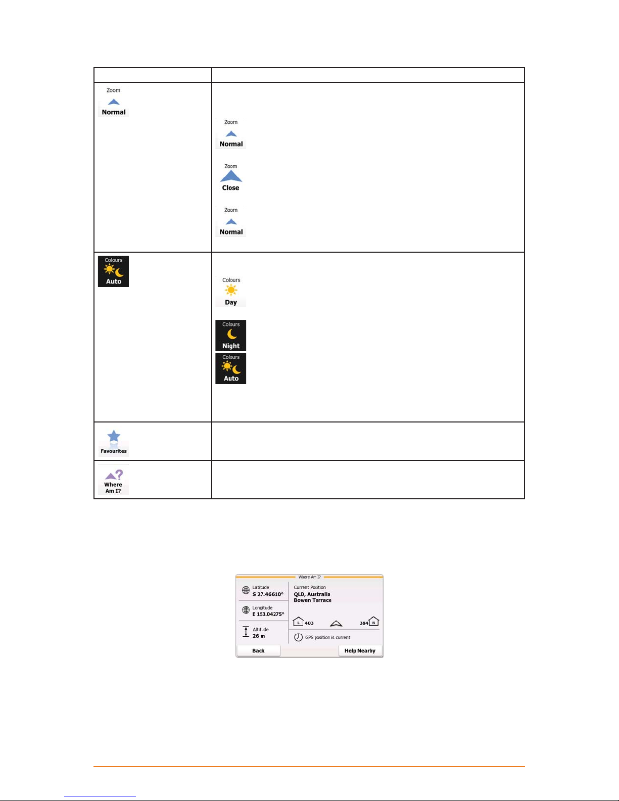
2.4.6 Checking the details of the current position (Where Am I?)
Opened from the Quick menu, this screen contains information about the current position (or about the
last known position if GPS reception is not available) and a button to search for useful Places nearby.
Page 23
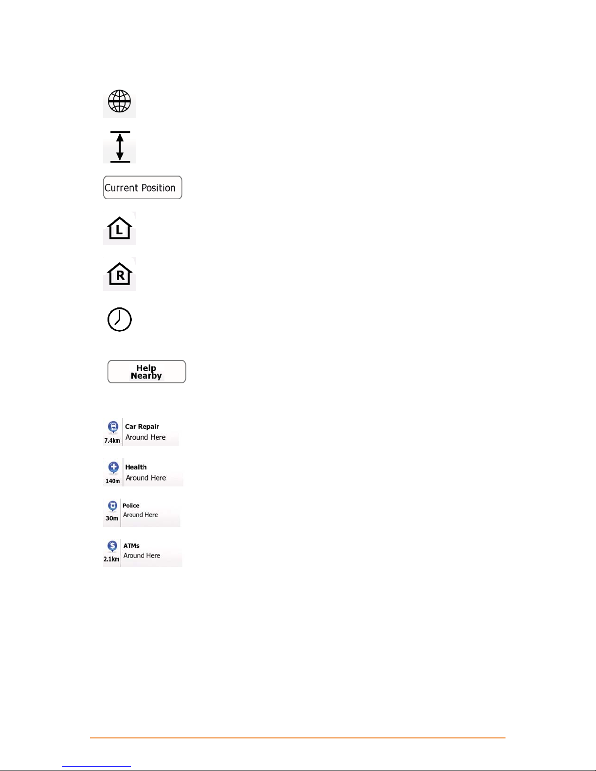
Information on this screen:
•
•
•
•
•
•
: Latitude and Longitude (coordinates of the current position in WGS84 format).
: Altitude (elevation information coming from the GPS receiver - often inaccurate).
: Address details (when available) of the current position.
: House number on the left.
: House number on the right.
: Shows whether the position is current, or the time left since it was last updated.
Besides these pieces of information, you can search for assistance near your current position.
Tap
to open a new screen for the Quick search:
The following services can be searched around the current position or the last known position:
•
•
•
•
: Car repair and roadside assistance services
: Medical and emergency services
: Police stations
: Cash dispensers
Tap any of the buttons, select a Place from the list, and navigate to it.
Page 24
 Loading...